|

Ordinary
Meeting Notice and Agenda
An Ordinary Meeting of the Bega Valley Shire Council will be held at Council Chambers, Biamanga Room Bega Commemorative Civic Centre on Wednesday,
20 July 2016 commencing at 2.00 pm to consider and resolve on the matters set out in
the attached Agenda.
14
July 2016
To:
Cr Michael Britten, Mayor
Cr Liz Seckold, Deputy Mayor
Cr Tony Allen
Cr Russell Fitzpatrick
Cr Keith Hughes
Cr Ann Mawhinney
Cr Kristy McBain
Cr Sharon Tapscott
Cr Bill Taylor
|
Copy:
General Manager, Ms Leanne Barnes
Director, Transport and
Utilities, Mr Terry Dodds
Director, Planning and
Environment, Mr Andrew Woodley
Director, Community, Relations
and Leisure, Mr Anthony Basford
Director, Strategy and
Business Services, Mr Lucas Scarpin
Executive Manager
Organisational Development and Governance, Ms Nina Churchward
Minute Secretary
|
|
Live Streaming of Council Meetings
Council meetings are recorded and live streamed to the
Internet for public viewing. By entering the Chambers during an open
session of Council, you consent to your attendance and participation being
recorded.
The recording will be archived and made available on
Council’s website www.begavalley.nsw.gov.au. All care is taken to
maintain your privacy; however as a visitor of the public gallery, your
presence may be recorded.
Publishing Of Agendas And Minutes
The Agendas for Council Meetings and Council Reports for
each meeting are available from 5.00 pm one week prior to each Ordinary
Meeting, on Council’s website. A hard copy is also made available
to each Library Branch and at the Bega Administration Building reception desk.
The Minutes of Committee and Council Meetings are available
from 5.00pm on Council's Web Site on the Friday after the Meeting on Councils
website and hard copies distributed with the Agenda for the following meeting.
1. Please
be aware that the recommendations in the Council Meeting Agenda are
recommendations to the Council for consideration. They are not the
resolutions (decisions) of Council.
2. Background
for reports is provided by staff to the General Manager for presentation
to Council.
3. The
Council may adopt these recommendations, amend the recommendations, determine a
completely different course of action, or it may decline to pursue any course
of action.
4. The
decision of the Council becomes the resolution of the Council, and is recorded
in the Minutes of that meeting.
5. The
Minutes of each Council meeting are published in draft format, and are
confirmed, with amendments by Councillors if necessary, at the next available
Council Meeting.
If you require any further information or clarification
regarding a report to Counci, please contact Council’s Executive
Assistant who can provide you with the appropriate contact details
Phone (6499 2104)
or email execassist@begavalley.nsw.gov.au.
Ethical Decision Making and Conflicts of
Interest
A guiding checklist for Councillors, officers and community committees
Ethical decision making
·
Is the decision or conduct legal?
·
Is it consistent with Government policy, Council’s objectives
and Code of Conduct?
·
What will the outcome be for you, your colleagues, the Council,
anyone else?
·
Does it raise a conflict of interest?
·
Do you stand to gain personally at public expense?
·
Can the decision be justified in terms of public interest?
·
Would it withstand public scrutiny?
Conflict of interest
A conflict of interest is a clash between private interest
and public duty. There are two types of conflict:
·
Pecuniary
– regulated by the Local Government Act 1993 and Office of
Local Government
·
Non-pecuniary
– regulated by Codes of Conduct and policy. ICAC,
Ombudsman, Office of Local Government (advice only). If declaring a
Non-Pecuniary Conflict of Interest, Councillors can choose to either disclose
and vote, disclose and not vote or leave the Chamber.
The test for conflict of
interest
·
Is it likely I could be influenced by personal interest in
carrying out my public duty?
·
Would a fair and reasonable person believe I could be so
influenced?
·
Conflict of interest is closely tied to the layperson’s definition
of ‘corruption’ – using public office for private gain.
·
Important to consider public perceptions of whether you have a
conflict of interest.
Identifying problems
1st Do
I have private interests affected by a matter I am officially involved in?
2nd Is
my official role one of influence or perceived influence over the matter?
3rd Do
my private interests conflict with my official role?
Whilst seeking advice is generally useful, the ultimate
decision rests with the person concerned.
Agency advice
Officers of the following agencies are available during
office hours to discuss the obligations placed on Councillors, officers and
community committee members by various pieces of legislation, regulation and
codes.
|
Contact
|
Phone
|
Email
|
Website
|
|
Bega
Valley Shire Council
|
(02)
6499 2222
|
council@begavalley.nsw.gov.au
|
www.begavalley.nsw.gov.au
|
|
ICAC
|
8281
5999
Toll
Free 1800 463 909
|
icac@icac.nsw.gov.au
|
www.icac.nsw.gov.au
|
|
Office
of Local Government
|
(02)
4428 4100
|
olg@olg.nsw.gov.au
|
http://www.olg.nsw.gov.au/
|
|
NSW
Ombudsman
|
(02)
8286 1000
Toll
Free 1800 451 524
|
nswombo@ombo.nsw.gov.au
|
www.ombo.nsw.gov.au
|
TO: The
General Manager
Bega Valley Shire Council
Disclosure of pecuniary interests / non-pecuniary conflict of interests
In accordance with the Council’s Code of Meeting
Practice and the requirements of the Local Government Act 1993 and
regulations or dispensation issued by the Office of Local Government I
hereby disclose the following pecuniary interests and/or non-pecuniary conflict
of interests at the meeting as indicated below:
Ordinary meeting held on _____ / _____ / 20___
dd mm yy
|
Item no
& subject
|
|
|
Interest (tick one)
|
Pecuniary
interest Non-pecuniary
conflict of interest
|
|
* Nature of
interest
|
|
|
If
Non-pecuniary (tick
one)
|
Disclose
& vote Disclose
& not vote Leave
chamber
|
|
|
|
|
|
|
|
Item no
& subject
|
|
|
Interest (tick one)
|
Pecuniary
interest Non-pecuniary
conflict of interest
|
|
* Nature of
interest
|
|
|
If
Non-pecuniary (tick
one)
|
Disclose
& vote Disclose
& not vote Leave
chamber
|
|
|
|
|
|
|
* Note: Under the provisions of Section
451(1) of the Local Government Act 1993 (pecuniary interests) and Part 4
of the Model Code of Conduct prescribed by the Local Government (Discipline)
Regulation (conflict of interests) it is necessary for you to disclose the
nature of the interest when making a disclosure of a pecuniary interest or a
non-pecuniary conflict of interest at a meeting.
Agenda
Statement of Commencement of Live Streaming
Acknowledgement of Traditional Owners of Bega Valley Shire
1 Apologies and requests for leave of
absence
2 Confirmation Of Minutes
Recommendation
That the Minutes of the Ordinary Meeting and Closed session
held on 29 June 2016 as circulated, be taken as read and confirmed.
3 Declarations
Pecuniary,
Non-Pecuniary and Political Donation Disclosures to be declared and tabled.
4 Deputations (by prior arrangement)
5 Petitions
6 Mayoral Minutes
7 Adjournment to Standing Committees
Recommendation
That the Ordinary meeting of the
Council be adjourned for the purpose of dealing with staff reports to Standing
Committees.
8 Staff Reports – Planning and
Environment (Sustainability)
In accordance with Council’s Code of Meeting
Practice, this section of the agenda will be chaired by Cr Taylor.
8.1 Planning
Proposal for seven Deferred Sites in Bega Valley Local Environmental Plan 2013 10
8.2 Strategic
Direction for nine Deferred Sites in Bega Valley Local Environmental Plan 2013 18
8.3 Bega
Valley CLEP 2013 Minor Amendments.............................................................................. 90
8.4 Report
on public exhibition of South Pambula Residential Land Planning Proposal.......... 95
8.5 Report
on exhibition of amendments to Clause 5.6 Tree and Vegetation Preservation of
Development Control Plan 2013..................................................................................................................... 103
8.6 Report
of Public Hearing - Reclassification of Lot 5 Section 7 DP 758087 Hoskins
Street, Bemboka..................................................................................................................................................... 105
8.7 Proposed
Vehicle Repair Station, Princes Highway Cobargo................................................ 119
8.8 Construction
of supermarket and liquor store and associated car parking, signage, earthworks
and 2 lot subdivision................................................................................................................................. 121
9 Staff Reports – Community,
Culture and Leisure (Liveability)
In accordance with Council’s Code of Meeting Practice
, this section of the agenda will be chaired by Cr Tapscott.
9.1 Access
Advisory Committee....................................................................................................... 158
9.2 Council
Grants Review................................................................................................................. 168
9.3 Halls
Maintenance Funding 2016/17........................................................................................ 176
9.4 Sportsground
Facility Management Plans................................................................................ 179
9.5 Quarterly
Community Project Proposals Summary................................................................ 315
10 Staff Reports
–Economic Development and Business Growth (Enterprising)
In accordance with Council’s Code of Meeting
Practice, this section of the agenda will be chaired by Cr McBain.
10.1 RFT
02/16 Gateway Signage to the Bega Valley...................................................................... 324
10.2 Expression
of Interest EOI 53/16 142-144 Imlay Street, Eden............................................. 326
11 Staff Reports – Infrastructure Waste and
Water (Accessibility)
In accordance with Council’s Code of Meeting
Practice, this section of the agenda will be chaired by Cr Fitzpatrick.
11.1 Formalisation
of road name: Joey Lane, Candelo................................................................... 330
11.2 Road
closure of a section of Council public road in Eden..................................................... 332
11.3 Merimbula
Lake and Back Lake Flood Study - Draft Report for Public Exhibition............. 359
11.4 Bega
Valley Local Traffic Committee - 6 July 2016................................................................. 487
11.5 RFT
42/16 Watermains Renewals and/or Upgrades 2016-2018......................................... 490
11.6 RFT
19/16 Rehabilitation and restoration of sewer manhole structures 2016/17 and
2017/18 492
11.7 RFT
49/16 Condition Assessment of Water and Sewerage Facilities.................................. 494
12 Staff Reports –
Governance and Strategy (Leading Organisation)
In accordance with Council’s Code of Meeting
Practice, this section of the agenda will be chaired by Cr Mawhinney
12.1 Review
of the Bega Valley Shire Community Service Medallion Committee .................. 498 .
13 Staff Reports – Finance (Leading
Organisation)
In accordance with Council’s Code of Meeting
Practice, this section of the agenda will be chaired by Cr Hughes
13.1 Certificate
of Investments made under Section 625 of the Local Government Act, 1993 512.
14 Adoption of Reports from Standing Committees
Recommendation
That all motions recorded in the
Standing Committees, including votes for and against, and acknowledging
declarations of interest already made, be adopted in by the Ordinary Council
meeting.
15 Delegates Reports
15.1 2016
National General Assembly of Local Government........................................................ 517
16 Rescission/alteration Motions
17 Notices of Motion
18 Urgent Business
19 Questions On Notice
19.1 Changes
to Property Addresses within Bega Valley Shire..................................................... 524
19.2 Tura
Marrang Library and Community Centre........................................................................ 528
20 Questions for the Next Meeting
21 Items of Interest Relating to Council Business
22 Confidential Business
Representations by members of the public regarding
closure of part of meeting
Adjournment Into Closed Session, exclusion
of the media and public......................... 529
22.1 General
Manager Annual Performance Review for period ending 30 June 2016
This report is confidential in accordance with section
10A (2) (a) of the Local Government act 1993 as the report contains personnel
matters concerning particular individuals.
22.2 Eden
Land Matters
This report is confidential in accordance with section
10A (2) (a) (c) of the Local Government act 1993 as the report contains
personnel matters concerning particular individuals; AND the report contains
information that would, if disclosed, confer a commercial advantage on a person
with whom the Council is conducting (or proposes to conduct) business.
22.3 Bega
Land Matters
This report is confidential in accordance with section
10A (2) (a) (c) of the Local Government act 1993 as the report contains
personnel matters concerning particular individuals; AND the report contains
information that would, if disclosed, confer a commercial advantage on a person
with whom the Council is conducting (or proposes to conduct) business.
Statement of Cessation of Live Streaming for the period of the Closed
Session.
Statement of Re-Commencement of Live Streaming
23 Adoption of reports from Closed Session
24 Resolutions to declassify reports considered in
closed session
Staff Reports –Planning And Environment (Sustainability)
20 July 2016
In accordance with Council’s Code of Meeting
Practice (2011), this section of the agenda will be chaired by Cr Taylor.
8.1 Planning
Proposal for seven Deferred Sites in Bega Valley Local Environmental Plan 2013 10
8.2 Strategic
Direction for nine Deferred Sites in Bega Valley Local Environmental Plan 2013 18
8.3 Bega
Valley CLEP 2013 Minor Amendments...................................................... 90
8.4 Report
on public exhibition of South Pambula Residential Land Planning Proposal 95
8.5 Report
on exhibition of amendments to Clause 5.6 Tree and Vegetation Preservation of Development
Control Plan 2013....................................................................... 103
8.6 Report
of Public Hearing - Reclassification of Lot 5 Section 7 DP 758087 Hoskins
Street, Bemboka........................................................................................................................... 105
8.7 Proposed
Vehicle Repair Station, Princes Highway Cobargo........................... 119
8.8 Construction
of supermarket and liquor store and associated car parking, signage, earthworks
and 2 lot subdivision.......................................................................................... 121
|
Council 20 July 2016
|
Item 8.1
|
8.1. Planning Proposal for
seven Deferred Sites in Bega Valley Local Environmental Plan 2013
This report covers seven sites currently
deferred in the Bega Valley Local Environmental Plan 2013 and proposes that
they revert to the original zones and lot sizes exhibited under the draft Bega
Valley Local Environmental Plan 2010.
Director Planning and Environment
Background
Staff have
been preparing a series of Planning Proposals to finalise sites identified as
‘Deferred matters’ under Bega Valley Local Environmental Plan 2013
(BVLEP 2013). Following ongoing discussions with the Department of Planning and
Environment, and further investigation by staff, seven sites subject to this
report are recommended to revert to the zoning and lot sizes as publicly
exhibited in the draft Bega Valley Local Environmental Plan 2010 (draft BVLEP
2010).
In order to
remove the ‘Deferred Matter’ status from the subject properties, a
Planning Proposal is required to be prepared and submitted to the Gateway
Panel. The development of future land use strategies by Council for enterprise
lands, residential growth areas, small lot agriculture and rural living may see
some of these sites revisited in the future.
Strategic
The
following summarises the rationale for removing the ‘Deferred
Matter’ status from the seven sites and, if endorsed by Council, will
form the basis for the preparation of a Planning Proposal by staff.
a) Lot 445 DP
1061010, Lochview Farm Road, Lochiel
Recommendation:
Rural Landscape Zone (RU2) with a Minimum Lot Size of 120 Hectares.
The property
has an area of approximately 53 hectares and is the residue of an existing
holding, which has been subdivided in the past to create a number of rural
residential allotments. The Lochview Farm site was originally deferred from the
BVLEP 2013 following a request from the owner for an E4 Environmental Living
Zoning with and 1ha lot size. This request would have resulted in a rural
residential style subdivision.
The site was
not supported by the Department of Planning and Environment due to the location
of the property being distant from the existing settlement of Pambula and the
existing rural residential land supply in the Lochiel and Pambula areas.
The site is
over 7km to South Pambula residential area and over 10km to Pambula shopping
centre. In addition, the rural residential supply for Lochiel and Pambula is
considered to be sufficient for the next 30 years. It is recommended to un-defer
the land to the originally exhibited draft BVLEP 2010 zoning as shown in Figure
1.
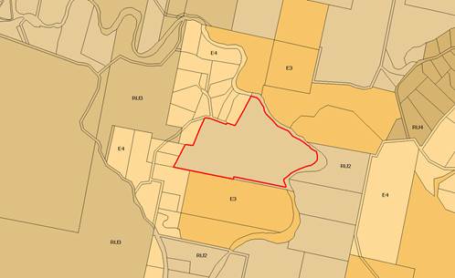
Figure 1: Lochview Farm Road, Lochiel: Land Use Zones
(Exhibited draft BVLEP
2010)
b) Lot 4892 DP
1103062, Woodlands Lane, Bald Hills
Recommendation:
Rural Landscape Zone (RU2) with a Minimum Lot Size of 120 Hectares.
Discussions
with the Department of Planning and Environment have indicated that the
proposed environmental living zoning will not proceed through the Gateway
process. The Department’s objections relate to existing rural residential
land supply in the Bald Hills and Pambula areas, distance from Pambula and lack
of strategic policy to support the expansion of the adjacent rural residential
zone. The Department also does not support using the rezoning process as a
mechanism to address infrastructure issues.
Existing
supply of rural residential land is currently forecast at approximately 30 years,
and as such further rezoning of rural residential land is not justified in this
catchment. Should Council wish to pursue the rezoning of this site, it is
suggested that the property owner undertakes further work to support his
request.
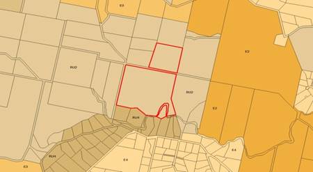
Figure 2: Woodlands Lane, Bald Hills: Land Use Zones
(Exhibited draft BVLEP 2010)
c) Part Lot 1
DP 1164038, Lots 1 & 2 DP 1101354, Tathra Road, Bega
Recommendation: Primary Production Zone (RU1) with a Minimum Lot
Size of 120 Hectares.
The subject land is part of a large dairy farming enterprise on the
eastern outskirts of Bega. The property has significant dairying and irrigation
infrastructure, and is used for grazing and fodder production to support the
dairy farming operation.
Draft BVLEP
2010 proposed a RU1 Primary Production zoning, with a minimum lot size of 120
Ha. Council received a request to rezone the land to R5 Large Lot Residential
and as such the site was deferred from BVLEP 2013.
This
property is one of only two large parcels of land to the south of Bega left
available for the future residential expansion of Bega and that retention of
the rural zoning effectively “land banks” the site for future
residential needs. This property would be included in a future residential
growth strategy that the Department of Planning and Environment is encouraging
Council to prepare as part of its ongoing strategy development program.
Primary
production (dairying) is still occurring on the site and is planned to continue
for at least the medium-term as is evidenced by infrastructure improvements
proposed for the site. It is proposed to advise the property owners of
Council’s vision for this site to allow them to continue planning for
infrastructure investment for the property.
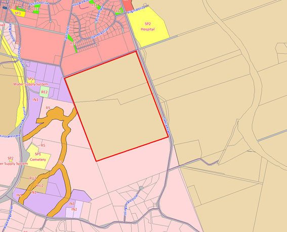
Figure 3: Tathra Road, Bega: Land Use Zones (Exhibited draft BVLEP
2010)
d) Lots 1 - 5 DP
455379, Palestine Road, Eden
Recommendation: Large Lot Residential (R5) with a Minimum Lot
Size of 5,000m2.
These lots are located on the north western side of the Princes Highway
and Government Road intersection, where Palestine Road intersects with the
Highway. They were originally exhibited as R5 Large Lot Residential in draft
BVLEP 2010 as part of a wider rural residential area on the northern outskirts
of Eden.
The lots
were proposed by the landowner to be zoned for industrial purposes to allow for
small lot Industrial uses. The site is topographically separated from the
existing North Eden Industrial areas and does not have appropriate Highway
intersection access. There is sufficient small lot industrial land capacity
within the existing North Eden Industrial estates and further vacant industrial
land adjacent to the caryards on Imlay Street.
The request
is not supported as industrial usage of this site would be in conflict with the
existing adjoining rural residential properties. There is no clear strategic
justification for the land to be rezoned as industrial land as there is
significant capacity in the existing Eden industrial estates and there are
major highway intersection constraints.
Figure 4: Palestine Road, Eden: Land Use Zones
(Exhibited draft BVLEP 2010)
e) Part Lot
600 DP 1193160, Mirador Drive, Merimbula
Recommendation:
Low Density Residential (R2) with a Minimum Lot Size of 2,000m2..
This site in Mirador site was deferred from BVLEP 2013 following a
request from the owner that Stage 13 of Mirador Estate (the subject land) be
changed from R2 Low Density Residential (as exhibited in draft BVLEP 2010) to
R3 Medium Density Residential and the minimum lot size be changed from 2,000m2
to 450m2. The exhibited 2,000m2 lot sizing was based on
servicing (sewerage) constraints.
This request
represents a significant departure from the long term planning for the Mirador
Estate and would result in a higher density style of subdivision not found
elsewhere in the Shire. In 2014 Council resolved to request the owner of the
land to undertake further work to support their request including a servicing
strategy for the Mirador Estate subdivision, bushfire assessment, access
arrangements including emergency access, and threatened species assessment.
Despite
requests from staff to provide the results of the servicing investigations and
other studies, the owners of the land have not provided this information. As
such it is recommended that the zoning and lot sizes revert to those exhibited
and that the owners be advised that should they wish to proceed with an
alternative zoning and lot sizing, they will have to prepare a detailed
Planning Proposal based on the previously requested information.
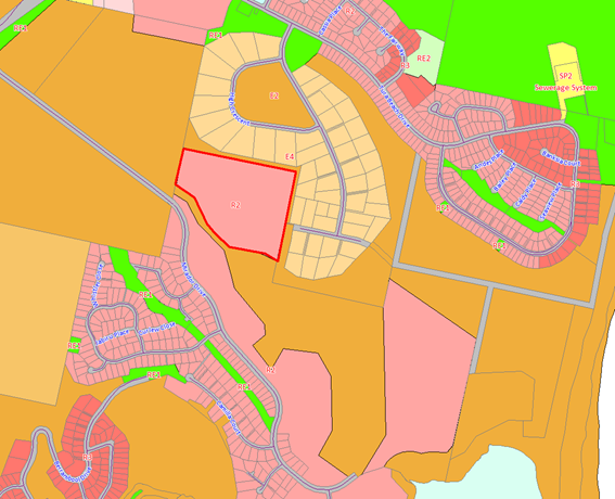
Figure 5: Mirador Drive, Merimbula: Land Use Zones
(Exhibited draft BVLEP 2010)
f) Lot 5
DP 1021345, Princes Highway, Wolumla
Recommendation:
RU1 Primary Production with a Minimum Lot Size of 120 Hectares.
The
‘Wanatta’ property is 144ha and is currently used for grazing and
beef production. The site was exhibited as RU1 Primary Production zone with a
120ha lot size and deferred from BVLEP 2013 following a request from the
landowner for a zone permitting rural residential subdivision.
Rural residential zoning of this
site is not supported as there is ample supply within the Wolumla catchment,
the majority of which is more appropriately located adjacent to the Wolumla
Village. This is proposed to be supplemented by land identified through the draft
Wolumla Growth Strategy at properties on the western and southern fringes of
Wolumla Village.
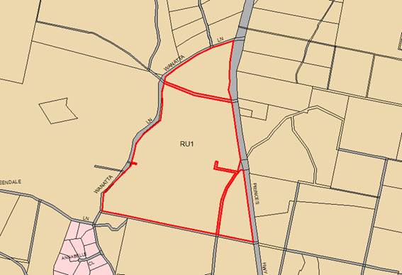
Figure 6: Princes Highway,
Wolumla (Exhibited draft BVLEP 2010)
g) Lot 3 DP 750226,
Polacks Flat Road, Bemboka
Recommendation:
RU1 Primary Production with a Minimum Lot Size of 120 Hectares.
Following
the exhibition of draft BVLEP 2010 the owners of the subject site requested the
application of an RU4 Small Lot Agriculture Zone over part of the property. Despite
some positive small lot production aspects of this land, such as access to
permanent water, the property owner has not demonstrated the demand for
intensive horticultural or livestock activity opportunities in the Bemboka
catchment. A specific strategy for the appropriate application of RU4 zonings
across the various rural catchments of the Shire is part of the future work
program of Council’s Strategic Planning section and would be an
appropriate mechanism to assess such requests into the future.
Additionally,
there is an existing supply of rural living land zoned R5 Large Lot Residential
on the northern side of the Bemboka Village and a supply of concessional
allotments within the wider Bemboka catchment.
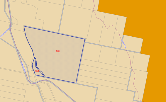
Figure 7: Polacks Flat Road,
Bemboka Proposed Zoning (Exhibited BVLEP 2010)
Conclusion
Following
discussions with the Department of Planning and Environment and ongoing
investigations by staff, it is recommended that the seven sites in this report
revert to the originally exhibited zonings and minimum lot sizes (as per draft
BVLEP 2010).
Some of
these sites may be revisited as part of the development of further land use
strategies by Council for enterprise lands, residential growth areas, small lot
agriculture and rural living. Individual land owners may also choose to submit
a Planning Proposal if they wish to pursue a rezoning in the meantime.
Attachments
Nil
Recommendation
1. That
the seven sites considered within this report be “undeferred” and
the zoning and lot sizes revert to those exhibited in draft Bega Local
Environmental Plan 2010 as follows:
a) Lot
445 DP 1061010, Lochview Farm Road, Lochiel
Rural Landscape Zone (RU2) with
a Minimum Lot Size of 120 Hectares
b) Lot
4892 DP 1103062, Woodlands Lane, Bald Hills
Rural Landscape Zone (RU2) with
a Minimum Lot Size of 120 Hectares
c) Part
Lot 1 DP 1164038, Lots 1 & 2 DP 1101354, Tathra Road, Bega
Primary Production (RU1) with a
Minimum Lot Size of 120 Hectares
d) Lots
1 – 5 DP 455379, Palestine Road, Eden
Large Lot Residential (R5) with
a Minimum Lot Size of 5,000m2
e) Part
Lot 600 DP 1193160, Mirador Drive, Merimbula
Low Density Residential (R2)
with a Minimum Lot Size of 2,000m2
f) Lot
5 DP 1021345, Princes Highway, Wolumla
RU1 Primary Production with a Minimum
Lot Size of 120 Hectares.
g) Lot
3 DP 750226, Polacks Flat Road, Bemboka
RU1 Primary Production with a Minimum
Lot Size of 120 Ha.
2. That
staff be authorised to forward a Planning Proposal to the Department of
Planning for Gateway determination for the seven sites considered in this
report.
3. That
following Gateway Panel determination the Planning Proposal be placed on
public exhibition.
4. That
at the end of the exhibition period a further report be submitted to Council
for consideration.
|
|
Council 20 July 2016
|
Item 8.2
|
8.2. Strategic
Direction for nine Deferred Sites in Bega Valley Local Environmental Plan 2013
This report
seeks Council’s resolution of a strategic direction for nine sites
currently deferred in Bega Valley Local Environmental Plan 2013 and to proceed
with the preparation of Planning Proposals for six of those sites.
Director Planning and Environment
Background
The gazettal of Bega Valley Local Environmental Plan
(BVLEP 2013) left a number of sites throughout the Shire as ‘Deferred
Matters’ as the zonings and/or lot sizes proposed by landowners
represented a significant departure from the exhibited draft Bega Valley Local
Environmental Plan (draft BVLEP 2010) or required more detailed investigations.
Council is requested to resolve a strategic direction
for each of the following nine (9) sites and for planning proposals to be
prepared for Sites 1 to 6 .
|
Site #
|
Subject Site
|
|
1
|
Boydtown Property (excluding the
area around the Seahorse Inn)
|
|
2
|
Summerhill Rd, South Pambula
|
|
3
|
Princes Highway, South Pambula
|
|
4
|
Old Mill Road, Wolumla
|
|
5
|
Princes Highway, Millingandi
|
|
6
|
Mandeni, Sapphire Coast Drive
|
|
7
|
Wolumla - Candelo Road, Wolumla
|
|
8
|
Clarke Street, Wolumla
|
|
9
|
Scott Street, Wolumla
|
Proposed
Strategic Direction
Site 1
– Boydtown Property (excluding the area around the Seahorse Inn)
The Southern
Joint Regional Planning Panel (JRPP) examined the Boydtown property in detail,
following the submission of a Masterplan and Planning Proposal by the property
owner. The JRPP made explicit recommendations with regard the zoning of the
majority of the Boydtown property. These recommendations were endorsed by the
Minister for Planning and Environment.
Following
the JRPP decision, officers have been in ongoing discussions with
representatives of the site’s owner. The owner has been strongly encouraged
to focus on the area east of the Princes Highway, around the Seahorse Inn and
proposed marina. Council has recently received a Planning Proposal covering
this area, which will be the subject of a future report to Council.
Officers
recommend the remainder of the site revert to the 2010 exhibited zonings of E2
and E3 in accordance with Council Policy applied across the Shire for sensitive
coastal and forested lands, with the exception of the cleared paddocks north of
the Nullica Short Cut Road, subject to the existing sand mining development
approvals. It is recommended this land be zoned RU2 Rural Landscape and the
north – south drainage line be protected by an E2 Environmental
Conservation zoning.
Further it
is advised a Planning Proposal from the property owner has recently been
received for this land. The Planning Proposal requests zonings and lot yields
that are inconsistent with the Decision of the JRPP, inconsistent with the
position of the Minister for Planning and Environment, inconsistent with
Council Policy applied across the Shire for sensitive coastal and forested
lands and is therefore not supported by Council officers.
A copy of
the owner’s Planning Proposal is included as Attachments 1 to this
report. Five appendices have been lodged with the main report covering the
subjects of Water Management Investigation; Economic Impact Assessment; Plans;
Visual Impact Assessment; and Constraints Analysis. The appendices will be
tabled at the Council Meeting.
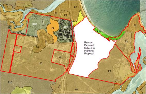
Recommendation:
That the land north of Nullica Short Cut Road be zoned RU2 (120ha) and E2
(no lot size); the remainder of the land west of the Princes Highway be zoned
E3 (10ha) and E2 (no lot size); and the south eastern section of the property
adjoining the Towamba River estuary be zoned E3 (40ha) and E2 (no lot size).
|
|
Draft
BVLEP 2010
|
Recommendation
for 2016 Planning Proposal
|
|
Zones
|
E2,
E3
|
E2,
E3, RU2
|
|
Lot
Sizes
|
10ha,
40ha, 120ha
|
10ha,
40ha, 120ha
|
Site 2 -
Summerhill Rd, South Pambula
The
Summerhill Road, South Pambula site is approximately 25ha in size and adjoins
the southern edge of the existing South Pambula residential area. The site was
deferred from the BVLEP 2013 subject to further investigation in the
‘Zenith Review’ of lands in Pambula and South Pambula. The
‘Zenith Review’ concluded the land was unsuitable for standard
residential development. As such officers proposed an E4 Environmental Living
zoning with a 1ha lot size as part of the subsequent ‘Pambula and South
Pambula Residential Land’ Planning Proposal, which was endorsed by
Council at its meeting of 7 May 2014. This proposal was rejected by the Gateway
Panel citing concerns around flora and fauna, bushfire, highway access and land
supply.
Council
officers have since undertaken detailed consultation with the Office of
Environment and Heritage (OEH), Rural Fire Service (RFS) and Roads and Maritime
Services (RMS), including site visits. Based on these consultations and further
site studies, a revised zoning pattern and minimum lot size is proposed as
shown below.
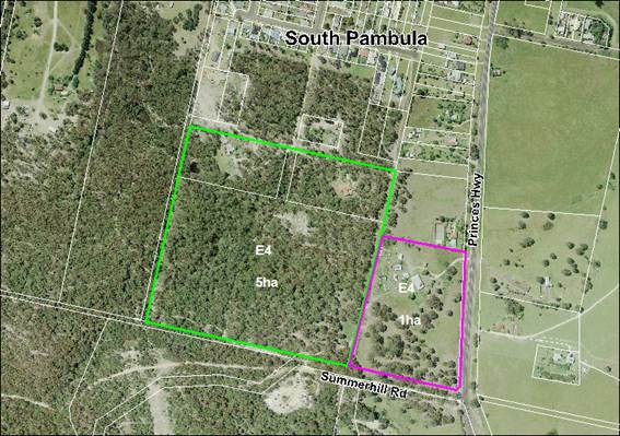
Recommendation:
That the land be zoned E4 with an 1ha lot size applied to the substantially
cleared, eastern section of the property and a 5ha minimum lot size be applied
to the western, more heavily vegetated section of the property.
|
|
Draft
BVLEP 2010
|
Recommendation
for 2016 Planning Proposal
|
|
Zones
|
RU2
|
E4
|
|
Lot
Sizes
|
120ha
|
1ha,
5ha
|
Site 3 - Princes Highway, South Pambula
Site 3
occupies the small rural valley to the south of Summerhill Road, Pambula and is
approximately 40ha in size. The owner of the site has submitted a Planning
Proposal for the site that seeks to have the property zoned E4 with a split of
2ha and 8ha minimum lot sizes. Council had previously resolved to support an E4
zone and lot sizing between 5ha and 10ha.
As with Site
2, this property faces significant highway access challenges. The site’s
owners are currently in discussion with the owners of Site 2 and another
neighbour to the north with a view to developing a comprehensive access
strategy for the three properties for a new highway intersection. Officers have
provided detailed feedback to the owners’ consultant with regard lot
yield, access, onsite sewage management and native vegetation. The Department
of Planning and Environment also requested further investigations of local land
supply to justify the rezoning of this site.
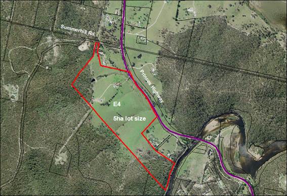
Recommendation:
That the land be zoned E4 with a 5ha minimum lot size and the consultant
acting for the owner be advised and encouraged to submit a revised Planning
Proposal based on this zoning and lot size.
|
|
Draft
BVLEP 2010
|
Recommendation
for 2016 Planning Proposal
|
|
Zones
|
RU2
|
E4
|
|
Lot
Sizes
|
120ha
|
5ha
|
Site 4 - Old Mill
Road, Wolumla
Properties along Old Mill Road have previously been subdivided using
concessional allotment entitlements, resulting in over 20 small rural
residential lots adjoining Old Mill Road. Site 4 is located among a cluster of
these small lots. It has been the subject of extensive discussions between the
owners, Council, OEH and RFS.
The site has
extensive native vegetation coverage over the southern portion of the property.
Both OEH and RFS have concerns regarding this section of the property and do
not support subdivision of this area. OEH and RFS have both provided in
principal support for a draft subdivision concept based on an E4 zoning of the
disturbed land fronting Old Mill Rd and an E3 zoning of the heavily vegetated
southern section of the property. It is proposed to apply a 2ha lot size to the
E4 zone and 30ha minimum lot size for the E3 zoned land.
As with the
previous sites in this report, the Department of Planning and Environment has
requested more justification for the rezoning of this site, with a particular
focus on local land supply.
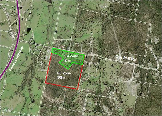
Recommendation:
That the land fronting Old Mill Road be zoned E4 with a 2ha lot size. The
remainder of the property be zoned E3 with a 30ha lot size.
|
|
Draft
BVLEP 2010
|
Recommendation
for 2016 Planning Proposal
|
|
Zones
|
RU2
|
E4,
E3
|
|
Lot
Sizes
|
120ha
|
2ha,
30ha
|
Site 5 -
Princes Highway, Millingandi
Site 5 covers an area of 18ha on the western side of Merimbula Lake
adjacent to Millingandi Creek. The site was exhibited with an E3 zoning and a
120ha minimum lot size, which would prevent any further subdivision. The site
was deferred following an address to Council in which a 5ha minimum lot size
was requested. The 5ha minimum lot size was supported by Council, provided an
On-site Sewage Management (OSSM) report was prepared to confirm the
site’s suitability for further subdivision.
The OSSM
report has recently been completed and indicates that Site 5 is only suitable
for one (1) additional lot, unless adjoining land (shaded green on the figure
below) can be acquired to provide for further effluent treatment capacity. The
owner of the site is currently negotiating to purchase the neighbouring land.
Should this purchase be achieved, the OSSM report indicates the newly expanded
property has the capacity for a maximum of three (3) lots (including the
existing dwelling).
Council
officers recommend the land retain its E3 zoning with a 7ha minimum lot size,
providing for one (1) additional lot. Should the neighbouring land be purchased
and incorporated into Site 5, the 7ha lot size would result in a total of two
(2) additional lots.
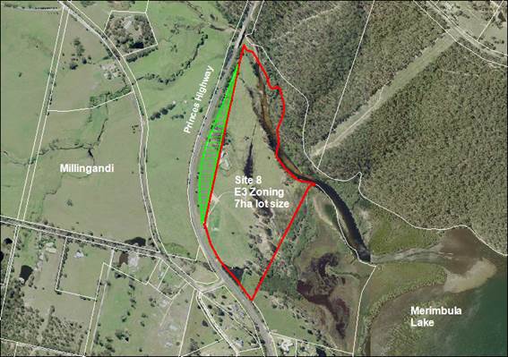
Recommendation:
That the land be zoned E3 with a 7ha minimum lot size.
|
|
Draft
BVLEP 2010
|
Recommendation
for 2016 Planning Proposal
|
|
Zones
|
E3
|
E3
|
|
Lot
Sizes
|
120ha
|
7ha
|
Site 6 - Mandeni, Sapphire
Coast Drive
Site 6 was deferred from BVLEP 2013 to allow for the owner to prepare a
comprehensive masterplan for the property. Council requested that key aspects
to be covered in the masterplan were to include the relocation of existing
approved lots away from high conservation value forest and a detailed
socio-economic and servicing strategy, to enable consideration to be given for
the subdivision of the existing tourist cabin development. Council has yet to
receive an updated masterplan for the site.
Council has
previously considered the relocation of the existing development entitlements
and subdivision of the cabins through a workshop and site visit. The relocation
of the existing development entitlements to the ‘racecourse
paddock’ was supported on the proviso that the relocated lots would not
be located within the forest fringe. The relocation of the development
entitlements will require an amendment of the exhibited zoning from RU2 to E4
for this part of the property. The high conservation value forest currently
zoned E4 in the eastern section of the property would be changed to E2.
Due to the
lack of a socio-economic and servicing strategy being received to support the
cabin subdivision, it is proposed to “un-defer” this section of the
property to the exhibited E4 zoning. Should the owner wish to continue to
pursue the subdivision of the cabins, they are able to submit a planning
proposal in the future based on the requested socio-economic and servicing
studies.
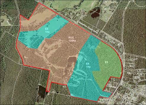
Recommendation:
That the land be zoned and lot sized E4 (1ha), RU2 (120ha) and E2 (no lot
size).
|
|
Draft
BVLEP 2010
|
Recommendation
for 2016 Planning Proposal
|
|
Zones
|
E4,
RU2
|
E4,
RU2, E2
|
|
Lot
Sizes
|
1ha,
120ha
|
1ha,
120ha
|
Sites
7, 8 and 9 are included in the draft Wolumla Growth Strategy currently being
prepared by staff and recently presented to Councillors in a workshop session.
Site 7 - Wolumla - Candelo Road, Wolumla
Site 7 was
originally deferred from BVLEP 2013 based on the need for the owner to
undertake master planning for the site, preferably in cooperation with the
neighbouring property (Site 8), to ensure a consistent, well planned expansion
of the Wolumla village and rural residential land.
Council has
not been provided with any further supporting documentation, studies or
concepts for this land. As such officers have developed proposed zonings for
the site, based on an overall draft strategic vision for the future growth of
Wolumla. The site has several environmental, physical (large drainage lines,
topography) and servicing constraints, which have been considered as part of
the recommendation for this property.
Part of the
property fronting Wolumla – Candelo Road is proposed for the future
expansion of the village.
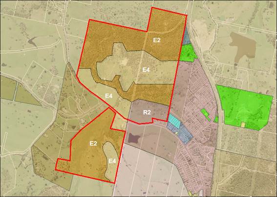
Recommendation:
That the strategic direction for the land in the draft Wolumla Growth
Strategy be E4 with a 4ha lot size, E2 with a 30ha lot size south of Wolumla
Road and R2 with a 550m2 lot size for further investigation and
report back to Council.
|
|
Draft
BVLEP 2010
|
Recommendation
for Further Investigation
|
|
Zones
|
RU4,
E2
|
E4,
E2 and R2
|
|
Lot
Sizes
|
2ha,
10ha
|
4ha
(E4), 30ha (E2 south of Wolumla Road), 550m2 (R2)
|
Site 8 -
Clarke Street, Wolumla
Site 8
directly adjoins the eastern boundary of site 7 and the western side of the
current village. The site was exhibited with a mix of RU5 Village, RU4 Primary
Production Small Lot and E2 zonings, however was subsequently deferred as a
result of the owners requesting an expansion of the RU5 zone and consideration
of B5 Business Development zone adjacent to the Highway. The owners were
encouraged to undertake further master planning of the site to demonstrate how
it could be integrated and connected to the existing village.
The
site’s owners have engaged consultants to undertake detailed master
planning for the site, based on the expansion of the existing village footprint
and connectivity to the existing road network of Wolumla. They are also
considering a small area of commercially zoned land within their holding. The
location of the commercial land proposed by the owners has not been finalised,
however officers are of the opinion a B4 Mixed Use zone near to the existing
centre of the village is most appropriate subject to further investigation.
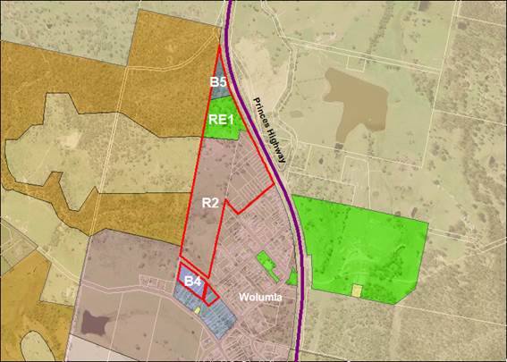
Recommendation:
That the strategic direction for the land in the draft Wolumla Growth
Strategy be R2 with a 550m2 lot size, B4 (no lot size), B5 (no lot
size) and RE1 (no lot size) for further investigation and report back to
Council.
|
|
Draft
BVLEP 2010
|
Recommendation
for Further Investigation
|
|
Zones
|
RU4,
RU5, E2
|
R2,
B4, B5 and RE1
|
|
Lot
Sizes
|
1,000m2
|
550m2
(R2)
|
Site 9 -
Scott Street, Wolumla
Site 9 was
deferred from BVLEP 2013 following a request from the landowner for a smaller
minimum lot size over the proposed R5 Large Lot Residential zone. The proposed
R5 zone encompasses 50ha of former grazing land, which is largely cleared with
a series of major drainage lines, running across the property. The R5 zoned
area was exhibited with a 2ha lot size, however the land owner requested a
2,000m2 minimum lot size.
Council
officers are recommending a 2ha minimum lot size be retained for this part of
the property, as this potentially provides a lot yield of 25 lots. The Lot
Averaging clause can be used to achieve a range of lot sizes to address the
site’s topographical constraints. The draft Wolumla Growth Strategy, if
adopted by Council, would result in a large increase in both residential and
rural residential land supply around Wolumla meeting projected demands for the
next 25 years. As such there is no justification for a smaller minimum lot size
to the R5 zone within site 9.
The
exhibited RU5 Zone that covers a recently approved residential subdivision
south of Wolumla – Candelo Road and west of Scott Street is proposed to
be converted to a R2 zone through the draft Wolumla Growth Strategy. It is
proposed to retain the exhibited E2 and RU2 zones on the remainder of the
property.
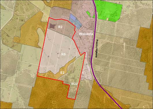
Recommendation:
That the strategic direction for the land in the draft Wolumla Growth
Strategy be R2 with a 550m2 lot size, R5 with a 2ha lot size, RU2
with a 120ha lot size and E2 (no lot size) for further investigation and report
back to Council.
|
|
Draft
BVLEP 2010
|
Recommendation
for Further Investigation
|
|
Zones
|
RU5,
R5, RU2, E2
|
R2,
R5, RU2, E2
|
|
Lot
Sizes
|
1,000m2,
2ha, 120ha
|
550m2,
2ha, 120ha
|
Consultation
If adopted
by Council, planning proposals prepared for sites 1 to 6 will be placed on
public exhibition following Gateway determination from the Department of
Planning and Environment. Sites 7 to 9 require further investigation by staff
and report back to Council prior to public exhibition.
Conclusion
This report
provides strategic direction to Council officers to move forward with the
finalisation of six deferred sites. Should the recommendations of this report
be adopted, Planning Proposals will be prepared for Sites 1- 6 to amend the
BVLEP 2013 in accordance with those recommendations.
The report
also provides strategic direction for Sites 7 – 9 to enable staff to
further investigate those sites in the context of the draft Wolumla Growth
Strategy (currently under preparation). Once prepared, it is proposed that the
draft strategy be reported to Council with the aim of facilitating public
exhibition at that time.
Attachments
1. Boydtown
Planning Proposal (from the owner)
|
Recommendation
1. That
the zoning and lot sizes for Sites 1 - 6 be as follows:
a) Site
1 – Boydtown Property (excluding the area around the Seahorse Inn)
That the land north of Nullica Short
Cut Rd be zoned RU2 (120ha) and E2 (no lot size); the remainder of the land
west of the Princes Hwy be zoned E3 (10ha) and E2 (no lot size); and the
south eastern section of the property adjoining the Towamba River estuary be
zoned E3 (40ha) and E2 (no lot size).
b) Site
2 - Summerhill Rd, South Pambula
That the land be zoned E4 with a 1ha
lot size applied to the substantially cleared, eastern section of the
property and a 5ha minimum be applied to the western, more heavily vegetated
section of the property.
c) Site
3 - Princes Highway, South Pambula
That the site be zoned E4 with a 5ha
minimum lot size and the consultant acting for the owner be advised and
encouraged to submit a revised Planning Proposal based on this zoning and lot
size.
d) Site
4 - Old Mill Road, Wolumla
That the land fronting Old Mill Road be
zoned E4 with a 2ha lot size. The remainder of the property be zoned E3 with
a 30ha lot size.
e) Site
5 - Princes Highway, Millingandi
That the land be zoned E3 with a 7ha
minimum lot size.
f) Site
6 - Mandeni, Sapphire Coast Drive
That the land be zoned and lot sized E4
(1ha), RU2 (120ha) and E2 (no lot size).
2. That
staff be authorised to forward Planning Proposals to the Department of
Planning for Gateway determination for Sites 1 - 6 as per the zoning and lot
sizes resolved above.
3. That
following Gateway determination the Planning Proposals be placed on public
exhibition and, following the exhibition period, a further report be
submitted to Council for incorporation of the subject land into Bega Valley
Local Environmental Plan 2013.
4. That
the strategic direction for further investigation of Sites 7 - 9 in the draft
Wolumla Growth Strategy be as follows:
a) Site
7 - Wolumla - Candelo Road, Wolumla
That the land be zoned and lot sized E4
(4ha), E2 (30ha south of Wolumla Rd) and R2 (550m2).
b) Site
8 - Clarke Street, Wolumla
That the land be zoned and lot sized R2
(550m2), B4 (no lot size), B5 (no lot size) and RE1 (no lot size).
c) Site
9 - Scott Street, Wolumla
That the land be zoned and lot sized R2
(550m2), R5 (2ha), RU2 (120ha) and E2 (no lot size).
5. That
once prepared by staff, the draft Wolumla Growth Strategy be reported to
Council with the aim of facilitating public exhibition at that time.
|
|
Council
|
20 July 2016
|
|
Item 8.2 - Attachment 1
|
Boydtown Planning Proposal (from the owner)
|

|
Council 20
July 2016
|
Item 8.3
|
8.3. Bega Valley
CLEP 2013 Minor Amendments
This report
requests Council to resolve to prepare a Minor Amendments Planning Proposal to
rectify minor mapping errors and heritage omissions and adjust land use tables
within Bega Valley CLEP 2013.
Director Planning and Environment
Background
The
implementation and application of Bega Valley Local Environmental Plan 2013
(BVLEP 2013) has inadvertently resulted in a number of minor zoning and
heritage mapping errors. Several heritage items require their status to be
updated in the Schedules of the BVLEP 2013, whilst staff have identified the
need to update land use tables to ensure certain activities are permissible. In
order to make these minor amendments to BVLEP 2013, a Planning Proposal is
required.
Staff have
made representations to the Department of Planning and Environment, requesting
that a more efficient and streamlined approach be adopted by the Department in
dealing with these minor matters. At this stage there has been no response to
these initiatives.
The Planning Proposal will be structured as follows;
a) Zoning
Map Amendments
b) Heritage
Map and Schedule Amendments
c) Land
Use Table Amendments
d) BVLEP
Clause Amendment.
Strategic
The Planning
Proposal would make minor, but important amendments to the BVLEP 2013. These
changes are important to ensure that the BVLEP remains contemporary and meets
the requirements of the land owners, the wider community and Council’s
Strategic direction.
a) Zoning
Map Amendments
Fifteen
parcels of land have been found to be incorrectly zoned on the BVLEP 2013 Land
Use Zoning Maps. The zoning errors are considered minor in nature and do not
have any significant economic, environmental or social impacts. Table 1 details
the proposed mapping amendments.
Table 1: Land Use Zoning Map Amendments
|
Location
|
Property
|
Landuse
|
Current
zoning
|
Amended
zoning
|
|
Bega
|
Lot 8 Sec 2 DP 1085
|
Vacant
|
Public Recreation RE1
|
Light Industrial IN2
|
|
Brown Mtn
|
Lot 1 DP 746820
|
Power Station
|
National Park E1 (part only)
|
Environmental Management E3
|
|
Candelo
|
Lot 1 DP 811091,
Lot 323 DP 44296
|
Candelo Swimming Pool
|
Rural RU1
|
Public Recreation RE1
|
|
Cobargo
|
Lot 22 Sec 7 DP 485
|
Dwelling
|
Public Recreation RE1
|
Village RU5
|
|
Eden
|
Part Lot 12 DP 829854
|
Dwelling
|
Public Recreation RE1
|
Low Density Residential R2
|
|
Eden
|
Part Lot 142 DP 567009
|
Dwelling
|
Public Recreation RE1 (part only)
|
Low Density Residential R2
|
|
Eden
|
Lot 78 DP 809238, Lot 30 DP 703279
|
Bushland
Public Reserve
|
Low Density Residential R2
|
Environmental Conservation E2
|
|
Merimbula
|
Lot 51 DP 883129
|
Bushland Public Reserve
|
Low Density Residential R2
|
Environmental Conservation E2
|
|
Mogareeka
|
Lot 13 DP 710669
|
Dwelling
|
Public Recreation RE1
|
Environmental Living E4
|
|
Quaama
|
Lots 1 – 3 Sec 8 DP 758860
|
Quaama Park
|
Village RU5
|
Public Recreation RE1
|
|
Tathra
|
Lot 7 DP 263659
|
Dwelling
|
Public Recreation RE1
|
R2 Low Density Residential
|
|
Towamba
|
Lot 8 DP 107143
|
Towamba Rec. Reserve / Hall
|
Village RU5
|
Public Recreation RE1
|
|
Wyndham
|
Lot 10 DP 607581
|
Dwelling
|
Public Recreation RE1
|
RU5 Village
|
|
Wyndham
|
Lot 1 DP 1172468
|
Tennis Courts
|
Village RU5
|
Public Recreation RE1
|
b) Heritage
Map and Schedule Amendments
Ten
heritage items have been identified as needing amendment on the Heritage
Mapping Overlays or Schedule 5 of the BVLEP 2013. This includes the addition of
the historic public baths at the southern of Aslings Beach and ‘Thompsons
Point Baths’ in Snug Cove, Eden. The proposed amendments are detailed in
Table 2.
Table 2:
Heritage Mapping and Schedule Amendments
|
Heritage Item
|
Issue
|
Mapping Amendment
|
Schedule 5
|
|
Eden
Public School – building
circa 1857
|
Heritage item mapped on wrong lot.
|
Amend map to correct lot
|
N/A
|
|
Eden
Hopeton House A//163156
3-5 Bass Street
|
Lot D//164277 contains the main house,
but it is not listed in Schedule 5 or on the Heritage maps.
|
Add to map
|
List on Schedule
|
|
Boydtown
|
Listing and mapping incorrect. Lot 13
DP 608730 listed as Lot 18.
|
Amend map to correct lot
|
Amend Schedule
|
|
Kameruka Cemetery
|
Lot 140 DP 1064610 is not on the map
or on the Schedule.
|
Add to map
|
List on Schedule
|
|
Eden
Ocean Swimming Pools
|
Aslings Beach Rock Pool (formerly Eden
Memorial Swimming Pool) & Thompsons Point Baths, Snug Cove
|
Add to map
|
List on Schedule
|
|
Eden Killer Whale Museum
|
Both lots missing from Heritage map.
One of 2 lots missing from Schedule 5.
|
Add Lot DP 48609 &
Lot 1 Sec 6 DP 758379 to Heritage Map.
|
Add Lot 1 DP 48609 to Schedule
|
|
Bemboka
Kameruka Street
Lot 10 Sec 11 DP 758087
|
Incorrectly mapped as Heritage but
this lot has no buildings or other heritage significance.
|
Remove from Heritage Map
|
N/A
|
|
Bemboka
71 – 73 Loftus Street
Hobbs Cottage and Store
|
Lot 14 DP 805581 containing the Hobbs
Cottage and Hobbs Store is not on the Heritage map.
|
Add to Heritage Map
|
N/A
|
|
Eden
243 Imlay Street
Lot 1 DP 731580
|
Should have been transferred from
BVLEP 2002 LEP but was left off Schedule 5
|
Add to map
|
List on Schedule
|
|
Bega
Old Bega Racecourse Grandstand
Lot 320 DP 873498
|
Should have been transferred from
BVLEP 2002 LEP but was left off Schedule 5
|
Add to map
|
List on Schedule
|
c) Land
Use Table Amendments
The
following changes are recommended to the land use tables of the BVLEP:
Recommendation - Add
‘information and educational facilities’ to Medium Density
Residential Zone (R3 zone)
Rationale – This matter was
prompted by Eden Killer Whale Museum Committee which is considering an
expansion of the current facility on to adjoining land. The land under
consideration is zoned R3 Medium Density Residential which prohibits
‘information and educational facilities’. On consideration,
planning staff are of the opinion that information and educational facilities
should be permitted with consent in the R3 zone across the Shire. It should be
noted that information and educational facilities were previously permitted in
the equivalent 2(b) Medium Density Zone under BVLEP 2002. Amenity issues
generated by such land uses are generally minor and can be properly assessed at
the development application stage.
Recommendation - Add
‘restaurants and cafes’ in Neighbourhood Centres (B1 zone)
Rationale - Currently there are
several restaurants and cafes across the Shire operating on land zoned B1
Neighbourhood Centre. They are prohibited in the land use tables and operate
under existing use rights. To provide future certainty for small business, it
is proposed to allow ‘restaurants and cafes’ in the B1
Neighbourhood Centre zone.
d) CLEP
Clause Amendment
Allowing a larger floor space for
kiosks
Recommendation –
amend clause 5.4(6) to replace 20m2 with 50m2
Rationale - There has been
discussion amongst planning staff regarding the restrictive floor space limit
of 20m2 for kiosks described at Clause 5.4(6) of BVLEP 2013. Under
BVLEP 2002 kiosks were permitted to have a floor space of 50m2. This
was inadvertently reduced to 20m2 in the current BVLEP 2013. A floor space of
50m2 is considered an appropriate and functional size for kiosk
operations. The 30m2 increase in floor space will allow, for example
some additional seating and better functioning kitchens. It is proposed to
change the limit listed at Clause 5.4(6) of the BVLEP 2013 from 20m2
to 50m2.
Consultation
There has
been no public consultation on these proposed changes. With Council approval,
there will be a formal public exhibition period if the planning proposal
proceeds past the Department of Planning’s Gateway process.
Conclusion
The proposed
amendments to BVLEP 2013 detailed in this report are of a minor nature. In a
number of cases the proposed changes simply correct mapping or typographical
errors. The proposed changes to land use tables and Clause 5.4(6) will support
the activities of hospitality and tourism businesses and provide certainty for
café and restaurant owners in Neighbourhood Centres (B1 zone) currently
operating under existing use rights.
Attachments
Nil
|
Recommendation
1. That
Council resolves to adopt the land use zone mapping amendments as listed in
Table 1 of this report.
2. That
Council resolves to adopt the amendments to the Heritage mapping and Schedule
5 of Bega Valley Local Environmental Plan 2013 as detailed in Table 2 of this
report.
3. That
Council resolves to permit with consent ‘information and educational
facilities’ in the Medium Density Residential Zone (R3 Zone).
4. That
Council resolves to permit with consent ‘restaurants and cafes’
in Neighbourhood Centres (B1 Zone).
5. That
Council resolves to alter the maximum floor space for ‘kiosk’
from 20m2 to 50m2 listed at Clause 5.4(6) of Bega
Valley Local Environmental Plan 2013.
6. That
items 1-5 above form the basis of a ‘Minor Amendments Planning
Proposal’ to be prepared by staff and forwarded to the Department of
Planning and Environment for Gateway Panel determination.
|
|
Council 20 July 2016
|
Item 8.4
|
8.4. Report on
public exhibition of South Pambula Residential Land Planning Proposal
The purpose
of the report is to detail the outcomes of the public exhibition of the
Planning Proposal to rezone various lots in South Pambula R2 Low Density
Residential and RU2 Rural Landscape zones.
Director Planning and Environment
Background
Council at its
meeting held on 7 May 2014 gave consideration to a report recommending the Bega
Valley Local Environmental Plan 2013 (BVLEP 2013) be amended to rezone various
land in Pambula and South Pambula areas to R2 Low Density Residential and RU2
Rural Landscape zones. The resolution of that Council meeting included the
following:
“1. That
Council make the following amendments to Bega Valley Local Environmental Plan
2013:
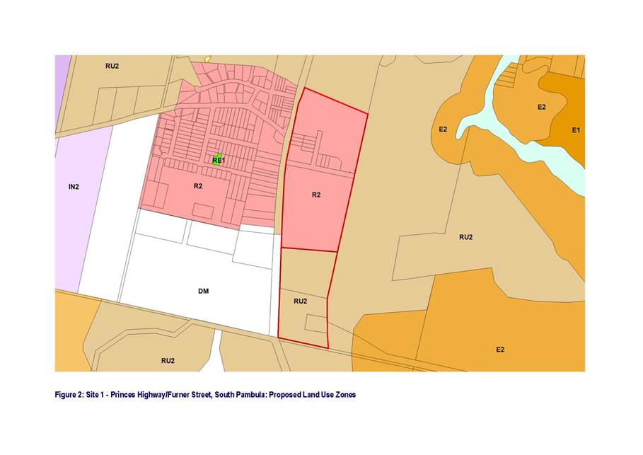
“1.3. Lots 1 and 2
DP197622, Lots 1 and 2 DP997328, Lots 1 and 2 DP195811, Lot 15 DP1022752, Lot 1
DP794830, Lots 1 and 2 DP794726, Lot 533 DP849212, Lot 510 & 511 DP877207,
Part Lot 11 and Lot 12 DP1076297 and Part Lot 321 DP1098908 identified in Map 4
as Area 3 be rezoned to part RU2 Rural Landscape and part R2 Low Density
Residential. Those lands to be zoned R2 shall have the Floor Space Ratio Maps
be amended to incorporate 0.5:1 and Minimum Allotment Size Maps be amended to
incorporate a minimum allotment size of 550m²” (Referred
to as site 1 in this report)
“1.5. Lot 9 DP700570
and Lot 10 DP563110 be zoned R2 Low Density Residential, that the Floor Space
Ratio Map be amended so both allotments reflect a ratio of 0.5:1 and that the
Minimum Allotment Size Map be amended so both allotments have a minimum
allotment size of 550m²”
(Referred to as site 2 in this
report)
2. That
Council proceed with a Planning Proposal for those lands identified above
… and, if agreed by the Minister for Planning, exhibit the subject
properties identified in accordance with the adopted recommendations”
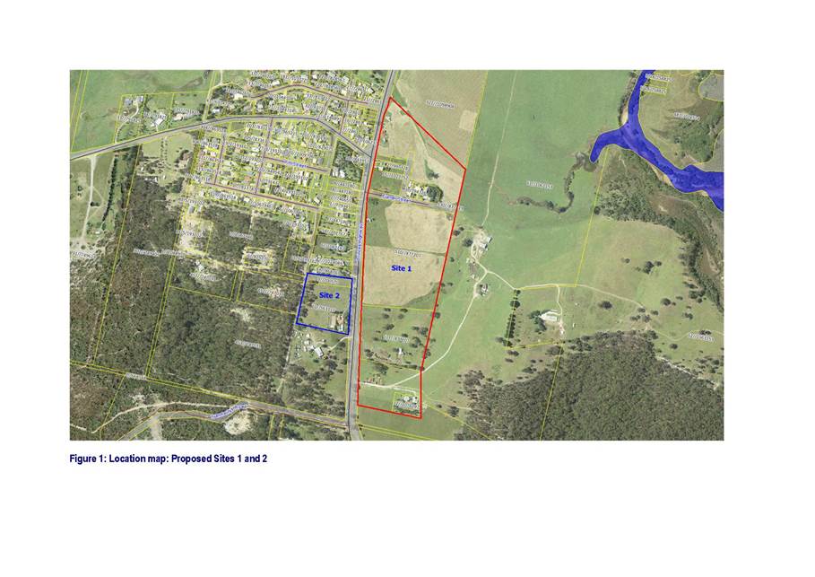
See Attachment 1 – Location, Zoning
and Lot Size maps
Exhibition of Planning Proposal
Council received delegation to make the
plan under Section 59 of the Environmental Planning and Assessment Act 1979
from the Minister of Planning and Infrastructure and Gateway Panel approval on
11 April 2015.
In accordance with the Gateway
Determination, the Planning Proposal was placed on public exhibition for 28
days from 11 May to 10 June 2016. The exhibition period was extended for an
additional period to 29 June 2016 to allow the community additional time to
consider the proposal.
The exhibition of the Planning Proposal
included notification on Council’s website, in local newspapers and in
writing to affected landowners and government agencies.
The Gateway Determination required
consultation with NSW Rural Fire Service, NSW Office of Environment and
Heritage, NSW Southern Rivers Catchment Management, NSW Department of Primary
Industries Agriculture, NSW Department of Primary Industries Fisheries, NSW
Department of Primary Industries Minerals and Petroleum, and NSW Roads and
Maritime Services.
A total of 11 submissions were received, 6
from government agencies and 5 public submissions. A copy of the
submissions will be tabled at the Council meeting.
Discussion of Submissions
NSW Rural Fire Service raised no objection to
the proposed zoning for either site and is satisfied that the proposal is
likely to be able to satisfy the required bushfire protection measures
identified in Planning for Bushfire Protection 2006.
NSW Office
of Environment and Heritage raised no objection to the proposed zoning for
either site.
NSW Southern Rivers Catchment Management Authority
advised that the agency does not provide comment at Planning Proposal
stage, unless it is likely that there will be a consent requirement for
clearing of native vegetation under the Native Vegetation Act 2003.
NSW
Department of Primary Industries Agriculture raised no objection to the
proposed zoning for either site and is satisfied that the proposal will not
adversely impact on agricultural viability of the land.
NSW
Department of Primary Industries Fisheries raised no objection to the proposed
zoning for either site as both sites can be serviced by a reticulated sewage
system.
NSW
Department of Primary Industries Minerals and Petroleum raised no objection to
the proposed zoning for either site and is satisfied that the proposal will not
impact mineral/extractive resources in South Pambula.
NSW Roads and Maritime Services raised concerns with
access as depicted in the conceptual subdivision layout in relation to the
Furner Street/Princes Highway intersection. RMS indicated that it did not
support the access in its proposed location as safe intersection sight distance
in both directions would not be achieved. Following a site inspection with RMS
and Council staff it was acknowledged that there was sufficient area along the
southern boundary of the proposed R2 area to accommodate an alternative access.
NSW Roads and Maritime Services raised no objection to
the proposed zonings, however noted that any future access off the Princes
Highway must be in accordance with Austroads Guide to Road Design.
Issues raised in the public submissions are outlined
below followed by staff comment:
The proposed lot size of 550sqm for both sites may
have adverse impacts on existing character and rural amenity for adjoining
residents.
· Staff have reviewed the proposed lot size of 550sqm
for both areas and consider it appropriate due to its suitability for
affordable residential development. The proposed lot size provides a logical
extension of the 550sqm lot size that applies to the South Pambula area to the
north west on either side of Mount Darragh Road.
As part
of the assessment process for any future development applications for the
subdivision of land, the lot size and layout would be assessed on merit in
accordance with the requirements of Bega Valley Local Environmental Plan 2013
and Bega Valley Development Control Plan 2013.
Safe vehicular access off the Princes Highway for both
sites
· As part of the assessment process for any future
development applications for the subdivision of land, access requirements would
have to be in accordance with Austroads
Guide to Road Design and integrated approval given by NSW Roads and Maritime
Services, including safe intersection sight distance.
Cost of road upgrade to Furner Street
· The cost for the provision of additional
infrastructure and upgrade of existing infrastructure associated with any
future subdivision applications would be at the developer’s cost.
Rezoning of flood affected land to the north of Furner
Street
· The portion of flood affected land to the north of
Furner Street is not in the planning proposal and will remain RU2 Rural
landscape zone. No flood liable land is proposed to be zoned for residential
purposes.
Establishment of riparian protection buffers zones
· A riparian corridor has been identified in the south
eastern corner of the proposed R2 zone of Site 1. Any future subdivision
application would have to be designed so as to maintain this buffer zone.
Conclusion
The Planning
Proposal provides for additional supply of residential opportunities to meet
future demand in South Pambula.
Council
staff have s considered the issues raised in the submissions, including those
from state agencies and the community, and consider that no changes to the
Planning Proposal (as exhibited) are warranted.
Attachments
1. Location,
Zoning and Lot Size maps
|
Recommendation
1. That
Council resolves to adopt the amendments to Bega Valley Local Environmental
Plan 2013 as shown in Attachment 1 of the report.
2. That,
using the delegations issued by the Minster for Planning and Infrastructure,
Council proceeds to finalise the plan under section 59(2) of the
Environmental Planning and Assessment Act 1979.
3. That
all those persons who have made submissions be advised of the Council
decision.
|
|
Council
|
20 July 2016
|
|
Item 8.4 - Attachment 1
|
Location, Zoning and Lot Size maps
|
|
Council 20
July 2016
|
Item 8.5
|
8.5. Report on
exhibition of amendments to Clause 5.6 Tree and Vegetation Preservation of
Development Control Plan 2013
The purpose
of the report is to detail the outcomes of the public exhibition of the
proposed amendments to Bega Valley Development Control Plan 2013 in relation to
Clause 5.6 Tree and Vegetation Preservation.
Director Planning and Environment
Background
Clause 5.9
of the Bega Valley Comprehensive Local Environmental Plan 2013 (BVLEP) details
the requirements for the removal and clearing of trees and native vegetation.
The objective of this clause is to preserve the amenity of the Bega Valley,
including biodiversity values, through the preservation of trees and other
vegetation prescribed under clause 5.6 of the Bega Valley Development Control
Plan 2013 (BVDCP).
The intent
of Clause 5.9 is to require Council approval in the form of a Tree Removal
Permit within nominated zones for the removal of trees, depending on the
location, size and species of the tree(s). Clause 5.9 requires development
approval for more broad scale clearing of vegetation, with exemptions being
available for matters subject to other legislation.
The
effectiveness of Clause 5.9 of the BVLEP is linked to the operational details
listed in Clause 5.6 of the BVDCP. Council officers became aware of an anomaly
within BVDCP Clause 5.6 which obstructed the full and appropriate use of BVLEP
Clause 5.9. The anomaly relates to the unintended exclusion of Large Lot
Residential (R5), Business Development (B5), Environmental (E2, E3 & E4),
Infrastructure (SP2) and Tourist (SP3) zones from the application section of
the clause.
The purpose
of this report is to correct this anomaly to ensure the removal of trees and
clearing of vegetation is adequately assessed in the Bega Valley, particularly
as the unintended exclusions include some of the more sensitive coastal
catchments, including areas of riparian vegetation and Endangered Ecological
Communities (EEC) that are vulnerable to incremental clearing.
Officers
reported this matter to the Council meeting held on 27 April 2016 recommending
the BVDCP 2013 be amended to rectify the unintended exclusion of Large Lot
Residential (R5), Business Development (B5), Environmental (E2, E3 & E4),
Infrastructure (SP2) and Tourist (SP3) zones from the application section of
the clause with Council resolving the following;
“That the amendments to
Clause 5.6 Bega Valley Development Control Plan 2013…with minor
amendments as outlined, correcting unintended omissions and clarifying the
approval requirements for tree removal and clearing of vegetation, be placed on
public exhibition for a period of 28 days in accordance with Clause 18 of the
Environmental Planning & Assessment Regulation 2000.”
Exhibition of Planning Proposal
In
accordance with Clause 18 of the Environmental Planning and Assessment
Regulation 2000, the amendment to BVDCP 2013 was placed on public exhibition for
28 days from 6 June to 1 July 2016.
The
exhibition of the amendment to BVDCP 2013 included notification on
Council’s website and in local newspapers, and was made available in
hardcopy at the Shire’s libraries.
No
submissions were received during the exhibition period.
Conclusion
The proposed
amendments to BVDCP 2013 correct an anomaly to ensure that the removal of trees
and clearing of vegetation is adequately assessed in the Bega Valley.
Council
officers consider no changes to the proposed amendments, as previously resolved
by Council and exhibited, are warranted.
Attachments
Nil
|
Recommendation
1. That
Council resolves to adopt the amendments to Bega Valley Development Control
Plan 2013 (as previously resolved and exhibited).
2. That
Council give public notice of the decision to amend the Bega Valley
Development Control Plan in accordance with the provisions of the
Environmental Planning and Assessment Regulation 2000.
|
|
Council 20 July 2016
|
Item 8.6
|
8.6. Report of
Public Hearing - Reclassification of Lot 5 Section 7 DP 758087 Hoskins Street,
Bemboka
The purpose
of this report is to detail the outcomes of the public hearing of the Planning
Proposal to reclassify Lot 5 Section 7 DP 758087 Hoskins Street, Bemboka from
‘Community land’ to ‘Operational land’.
Director Planning and Environment
Background
The Hoskins
Street Bemboka site was formerly utilised as the Bemboka Community Health
Centre and administered by the NSW Department of Health. In 2004 the NSW
Department of Health commenced a process to dispose of the property. In
response to concerns expressed from the Bemboka community, Bega Valley Shire
Council acquired the property in 2007 for a “peppercorn” amount. It
was classified as Community Land and a positive covenant imposed to ensure it
was used for the purposes of a health facility. Council resolved to commence
the preparation of a Plan of Management and conduct formal lease negotiations
with the Bemboka Community Health Centre Committee.
Since that
time a formal community group to manage the health facility has not been
involved as was planned under a formal arrangement to manage, operate and
maintain the facility and subsequently the objective of retaining a functional
health facility for the community has not been achieved. Council has incurred
costs since the acquisition of the property related to maintenance and
insurance.
Council
resolved on 2 September 2015 to request NSW Health Infrastructure to remove
positive covenant “AD46” from the title to the property and to
reclassify the property as Operational Land. Staff are currently finalising the
removal of the covenant with NSW Health.
The
Resolution of that Council meeting included the following:
“1. That
Council formally request NSW Health Infrastructure to remove positive covenant
number AD46 from the title of Lot 5 Section 7 DP 758087, Hoskins Street,
Bemboka.
“2. That
following removal of the covenant, Council engage the services of a planning
consultant to prepare a planning proposal to reclassify the land from Community
to Operational under Schedule 4 of the Local Environmental Plan and that the
proposal be forwarded to the NSW Department of Planning and Environment for
Gateway Panel determination”
Legal
Council
received a Gateway Determination for the Planning Proposal under Section 59 of
the Environmental Planning and Assessment Act 1979 from the Minister of
Planning and Infrastructure on 6 November 2015. In accordance with the Gateway
Determination, the Planning Proposal was placed on public exhibition for 28
days from 20 November to 18 December 2015 and 42 public submissions were
received by Council.
The
exhibition of the Planning Proposal included notification on Council’s
website, in local newspapers and in writing to adjoining land owners.
The Gateway
Determination did not require consultation with any public authorities or
Government Agencies under section 56(2)(d) of the Environmental Planning and
Assessment Act 1979 (the Act).
Zenith Town
Planning were engaged by Council to undertake the formal Public Hearing
process. The Public Hearing was held in the Bemboka Town Hall on 22 February
2016 in accordance with section 57 of the Act. The public hearing was notified
on Council’s website, in local newspapers and in writing to adjoining
land owners. The Report of Public Hearing that was prepared by Zenith Town
Planning is Attachment 1 of this report.
Consultation
Approximately
50 members of the public attended the hearing.
The
following section summarises the submissions presented at the public hearing.
Nine (9) members of the public made verbal
submissions.
Issues raised in the submissions were as follows:
a) The
wording of the notice advising of the public hearing in local media and posted
at Bemboka Post Office was misleading as it indicated that the purpose of the
public hearing was to discuss the future use of the land and where proceeds of
the sale would be spent.
Council Officer comment:
Although not specific to the village of Bemboka, the wording of that
notice is considered clear and unambiguous, advising that the reclassification
is to enable the property to be sold, with proceeds allocated to existing local
community facilities and programs. Unfortunately some attendees at the public
hearing had expectations of the meeting that were not met having anticipated
the allocation of funds would be discussed and debated.
b) The yards
and fence are currently maintained by neighbours. However, the building is in
poor condition due to lack of maintenance, contains asbestos, is a health
hazard and should be demolished. It was suggested that Council carry out the
demolition to ensure that it is done safely.
Council Officer comment:
There was divided opinion as to
whether the land should be reclassified and sold with some submitters
indicating their support for the planning proposal and others suggesting the
land should stay in community ownership, be restored and be used by the Bemboka
community.
c) The
community expressed unanimously that, should the reclassification proceed and
the land be sold, all proceeds of sale should be used for the benefit of the
Bemboka community.
Council Officer comment:
The process to reclassify lands does
not include decisions regarding disposal of the land or where the proceeds are
to be allocated. There are separate avenues to make submissions to Council
regarding these matters.
Strategic
Recommendations
of Planning Consultant
The Report
of Public Hearing as attached to this report makes the following conclusion and
recommendations;
Conclusion
The conduct
of the public hearing satisfied the procedural requirements of the Environmental
Planning and Assessment Act 1979 and the Local Government Act 1993. No
actions arise in response to the public hearing.
Reclassification
of the land to operational is supported as the intended use of the building has
not materialized and substantial costs are being incurred by Council for
maintenance and insurance. Following reclassification, the land may be used for
a purpose that is permitted with or without consent in zone RU5 Village.
The
condition of the building is not known and sale of the land may lead to the
refurbishment of the former health centre building for an alternative use. At
that time the community may have input during the assessment of a Development
Application. If the land is sold and demolition is proposed then such would
need to be carried out in accordance with legislation and policy regarding the
handling and disposal of asbestos materials.
The notice
of the public hearing is appended to this report. Although not specific to the
village of Bemboka, the wording of that notice is considered clear and
unambiguous, advising that the reclassification is to enable the property to be
sold, with proceeds allocated to existing local community facilities and
programs. Unfortunately some attendees at the public hearing had expectations
of the meeting that were not met having anticipated that the allocation of
funds would be discussed and debated.
Recommendations
The following recommendations are made in
response to matters raised during the public hearing:
• The
reclassification of Lot 5 Section 7 DP 758087 Hoskins Street, Bemboka proceed
and an amendment made to Bega Valley LEP 2013 to include the property in Schedule
4 Part 1 Land classified, or reclassified, as operational land – no
interests changed
• Should Bega Valley Shire Council resolve to sell the land
then the proceeds of sale be allocated to a community use in the village of
Bemboka that supports the health and wellbeing of residents
Policy
Council has an adopted Land Investment Strategy that
provides that land may be identified as no longer required for strategic
purposes. Such Council owned property may be divested.
Asset
Council has held the Bemboka house property since 2007
with restriction on use and no community group undertaking management and
responsibility for the site. There have been costs related to the building,
including insurance over that period but no income and the costs associated with
returning it to an operational community facility are not currently available
in Council’s Building Asset Management Plan. Quotations were obtained by
Council staff in 2012 for immediate works required to comply with current
standards for its continued use as a public building. Those works were in the
order of $60,000 at that time.
Social
/ Cultural
Council has
recently received representation from a local community group in Bemboka, who
have expressed interest in purchasing the building from Council. They have been
discussing options with Council’s Community, Relations and Leisure Group
regarding the purchase of the building and its range of potential community
focused uses. These discussions will be the subject of a future report to
Council.
Conclusion
The
reclassification of the Hoskins Street Bemboka site to Operational Land
provides Council with an appropriate level of flexibility with regards to the
ongoing administration, management or disposal of the site. This report
recommends the reclassification of the site as Operational Land and Council
Officers be authorised to move forward with examining options for its future
use or disposal.
Attachments
1. Zenith
Town Planning - Report of Public Hearing held on 22 February 2016
|
Recommendation
1. That
Council proceeds to finalise the Planning Proposal to amend Schedule 4 Part 1
of the BVLEP 2013 by reclassifying Lot 5 Section 7 DP 758087 Hoskins Street,
Bemboka from ‘Community Land’ to ‘Operational Land’.
2. A
further report be provided to Council regarding future uses of the site.
|
|
Council
|
20 July 2016
|
|
Item 8.6 - Attachment 1
|
Zenith Town Planning - Report of Public Hearing held on 22
February 2016
|

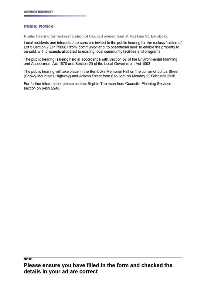
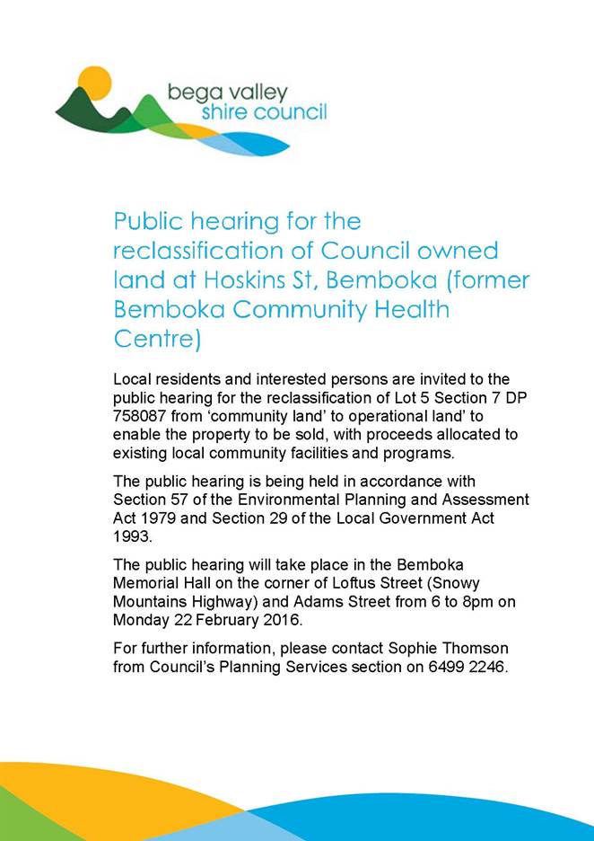
|
Council 20
July 2016
|
Item 8.7
|
8.7. DA No.
2015.283: Proposed Vehicle Repair Station, Princes Highway Cobargo
Director Planning and Environment
|
Applicant
|
T Bowen and FJ Ferguson c/- Plan Cert Consultants
|
|
Owner
|
T Bowen and FJ Ferguson
|
|
Site
|
31-33 Princes Highway, Cobargo – Lots 2 and 3
Section 13 DP 2591
|
|
Zone
|
RU5 Village Zone
|
|
Site area
|
2,725m2
|
|
Proposed development
|
Vehicle Repair Station
|
Precis
Development
Application 2015.283 has been withdrawn by the applicant. This report is
provided to Council for information purposes only.
Background
Council
considered a Council Officers' report on 27 April 2016 in relation to the
proposed construction of a vehicle repair station at 31-33 Princes Highway,
Cobargo.
The
recommendation by Officers was;
1. That
development application No. 2015.283 for a Vehicle Repair Station on Lots 2 and
3 Section 13 DP 2591 Princes Highway Cobargo be refused for the following
reasons:
a. The
proposed development would be inconsistent with the objective of the RU5 Village
zone as the development would not maintain or protect the existing village
character of Cobargo.
b. The
proposed development would be contrary to the objectives of Section 2.6 of the
Bega Valley Development Control Plan 2013, in that the development would not
preserve the existing amenity of the area and would be inconsistent with the
desired future character of Cobargo.
c. The
height, scale and bulk of the proposed development would be contrary to the
requirements of Section 5.2.3 and 5.2.4 of the Bega Valley Development Control
Plan 2013 as the development would have an adverse impact on heritage places
within the Cobargo Heritage Conservation Area and on the general character of
the Heritage Conservation Area.
d. The
proposed development would have an unacceptable impact on the visual and
acoustic amenity of existing residential dwellings in the immediate vicinity of
the development site.
Council heard
an address by Mr Paul Blacka on behalf of Mr Chris Norris and Council
subsequently resolved as follows;
1. That
the matter be deferred for a site inspection to be undertaken by Councillors.
2. That
a further report be prepared by staff including suitable development conditions
for approval.
A site
inspection was conducted on 1 June 2016 and was attended by available
Councillors and Council officers.
Further discussions with staff
After
Councillors had the opportunity to inspect the site, Council officers met
separately with the proposed operator/future landowner, Mr Chris Norris and his
building and planning representatives, to explore alternative options for the
site that may address some of the concerns raised in the assessment of the
Application.
The
possibility of a boundary adjustment to create a more functional development
site, suitably setback from the Princes Highway frontage, was discussed. As
Council’s Resolution requested suitable development conditions should the
Application be approved, officers requested the submission of an acoustic
report to inform the final construction method, setbacks and operational
parameters of the development, should Council resolve to approve the
Application.
The
applicant’s representatives have since advised Council staff the
preparation of an acoustic report will take some weeks, and that negotiations
are being held with the landowner and Mr Norris regarding the potential for a
more suitable boundary adjustment.
As such,
officers recommended the Development Application be withdrawn and a fresh
Application be submitted once these keys aspects have been resolved to the
satisfaction of the proponent and officers.
The
applicant was subsequently withdrawn on 1 July 2016. Officers will continue
discussions with the proponent regarding this development.
Conclusion
This matter
is reported to Council for information purposes only, to advise that
Development Application 2015.283 has been withdrawn.
Attachments
Nil
Recommendation
Council
notes that Development Application 2015.283 for a Vehicle Repair Station on
Lots 2 and 3 Section 13 DP 2591, 31-33 Princes Highway, Cobargo has been
withdrawn.
|
|
Council 20 July 2016
|
Item 8.8
|
8.8. DA No.
2015.437: Construction of supermarket and liquor store and associated car
parking, signage, earthworks and 2 lot subdivision
Director Planning and Environment
|
Applicant
|
Milestone (AUST) Pty Limited
|
|
Owner
|
Steelbull Pty Ltd
|
|
Site
|
Lot 11 DP 835239,
Merimbola Street, Pambula
|
|
Zone
|
B2 Local Centre
|
|
Site area
|
10,013m2
|
|
Proposed
development
|
Construction of
supermarket and liquor store and associated car parking, signage, earthworks
and 2 lot subdivision
|
Precis
In
accordance with the Resolution at the Council meeting held on 8 June 2016 a
site visit was held by Councillors on 23 June 2016.
This report
outlines the matters raised at the site meeting and also any issues raised in
the deputations to the Council meeting that were not addressed in the previous
report to Council.
Further,
since the Council meeting of 8 June 2016 the applicant has provided additional
details regarding the separation of delivery and customer vehicles onto
Merimbola Street which satisfies traffic engineering requirements.
The
Application is recommended for approval subject to the conditions in the Draft
Consent.
Background
A Council officer report was submitted to the Council
meeting held on 8 June 2016 with the following recommendation:
1. That
Development Application No. 2015.437 being for the construction of a
supermarket and liquor store, associated car parking, signage, earthworks and 2
lot subdivision at Lot 11 DP 835239 Merimbola Street, Pambula be approved on a
deferred commencement basis subject to the draft deferred commencement Consent
included as attachment 3 to this report.
2. That
those persons who made a submission be advised of the Council decision.
Council
resolved as follows:
1. The matter be deferred
for a site visit by Councillors.
Description of the proposal
The
Application seeks approval for the construction of a retail development
comprising supermarket, liquor store and associated car parking, earthworks and
signage.
The total
floor area of the retail space would be approximately 920m2. The
proposed building would have a maximum height of between 5.8m and 7.3m and
constructed of a combination of precast panels and metal cladding.
The proposal
also involves the filling of the land to RL 3.84m AHD for the footprint of the
retail space. The current RL of the land is approximately 2m AHD.
A total of
37 car parking spaces would be provided with access available from both
Merimbola and Bullara Streets.
A one-way
service vehicle access is proposed via a separate driveway from Bullara Street
which would loop around the back of the proposed building to the loading dock
then enter onto Merimbola Street.
All
deliveries to the development would enter Bullara Street from the Princes
Highway and be serviced by a 19 metre articulated vehicle and a 12.5 metre
large rigid vehicle.
The
applicant seeks consent for delivery hours to be between 7am and 6pm Monday to
Friday, and between 8am and 1pm weekends and Public Holidays.
The
applicant seeks consent to operate the supermarket and liquor store between the
hours of 7am and 10pm, seven (7) days per week.
The proposal
also involves the subdivision of the land into two (2) lots. Proposed Lot B
being the development lot with an area of 2,994m2 and proposed Lot A
being the residue with an area of 7,019m2. The proposed service
vehicle access would, in part, be located on Lot A. It is proposed to create a
right of carriageway over Lot A in favour of Lot B.
Description of the site
The subject
site has an area of 10,013m2, is located on the north eastern side
of the intersection of Merimbola Street and Bullara Street, Pambula and is
currently vacant.
The site is
square shaped with a western frontage to Merimbola Street of 101m, a northern
boundary of 101m, a southern boundary frontage to Bullara Street of 83m and an
eastern boundary of 90m. The south eastern corner of the site wraps around an
existing sewer pumping station, which is located on an adjoining lot (Lot 2 DP
569613). The site has a gentle fall towards Bullara Street to the south of
approximately 1m to 1.5m.
The site is
cleared and does not feature any significant topographical constraints. A
pedestrian footpath and cycleway has been constructed along the Bullara Street
frontage of the site.
The site is
located on the south-eastern corner of the Pambula Town Centre. The site is
adjoined by medium density residential land to the east and hardware and
building supplies premises (being the Mitre 10 site) to the north. A commercial
premises (being Lawrence and Hanson Electrical Wholesalers) and Council land
containing a community garden, Pambula Playground and Bennett’s Lane bus
stop is located on the opposite side of Merimbola Street to the west.
The Panboola
Wetlands is located on the adjacent land on the southern side of Bullara
Street.
Modified Proposal - Access onto Merimbola Street
The report
to the Council meeting of 6 June 2016 identified that the proposed combined
delivery and customer vehicle access onto Merimbola was unsatisfactory from a
traffic safety and engineering perspective and recommended three alternative
options that could be included in a ‘deferred commencement’
consent. Further discussions have been held with the applicant regarding this matter
which has resulted in an amended plan which provides for a separate delivery
and customer vehicle access arrangement which satisfies the traffic safety and
engineering issues raised.
Attachment 3
– Amended access arrangements.
Details
of Deputations to Council
Two
deputations were made to Council on the proposed Development Application.
Officers comment is provided on each of the deputations.
Mr Greg
Ferguson, resident of Pambula
The majority of issues raised in Mr Ferguson’s
deputation have previously been addressed in the report to Council of 8 June
2016. The following additional comments are provided by officers on several
other matters.
Impact on heritage values and village character of
Pambula
Impact on the heritage values of Pambula were assessed
by Council’s Heritage Advisor and advice received included in the report
to Council on 8 June 2016.
Officers consider the proposed development is a
contemporary design that is low-scale in bulk and height with regards to the
site context and the large buildings to the north and west of the site. The
proposed design incorporates modern building materials appropriate for the type
of retail development proposed and is considered to be of minimal impact to the
heritage items and heritage conservation area of Pambula.
Environmental impact
The issues raised in relation to environmental impacts
on Panboola Wetlands were addressed in the report to Council on 8 June 2016.
Mitigation of any potential impacts on Panboola Wetlands are proposed to be
addressed through compliance with the General Terms of Approval issued by the
NSW Office of Water, which requires a Controlled Activity Approval to be
granted prior to the issue of a Construction Certificate.
Officers consider the proposed development to be
satisfactory in regard to these matters.
Social impact
The Statement of Environmental Effects provided by the
applicant considers social impacts such as visible site entrances,
opportunities for passive surveillance and safety within the locality.
The NSW Police Force were consulted in relation to
this Application and advised the requirements for lighting, CCTV, and
landscaping should be consistent with the principles of Crime Prevention
Through Environmental Design and in accordance with Australian Standards. As a
draft condition of consent, a lighting plan is required by Council prior to the
issue of a Construction Certificate. The proposed landscaping between street
frontages and carpark areas has been designed to encourage natural surveillance
and clear sight lines. The development proposal includes a liquor outlet within
the commercial development. Police will address licencing issues when the
liquor licence application is made.
As part of the liquor licence application, the
applicant would need to prepare and submit to the Office of Liquor Gaming and
Racing (OLGR) a Community Impact Statement which would address social impacts
associated with an additional liquor outlet in the community.
For the purpose of assessment of the Development
Application, a liquor store is a retail outlet which is permissible in the
zone, suitable crime prevention through environmental design provisions have
been incorporated into the development and the limiting of trading hours is
considered to be reasonable to minimise potential adverse social impact on the
community.
Mr Kel
Stolzenhein, resident of Pambula
Economic impact (Including impact on local businesses
and devaluation of property prices)
The issues
raised in Mr Stolzenhein’s deputation, regarding economic impacts, have
been fully documented and considered in the officer's assessment as detailed in
the report to Council of 8 June 2016.
It should be
noted the findings of the Location IQ Economic Impact Assessment are consistent
with those of the economic assessment report by Foresight Partners and provided
as part of the previous supermarket Development Application for the site.
The impact on existing businesses within the township
as a result of the proposed development, in terms of business competition, is
not a matter for Council in its Planning Consent Authority role.
The impact on property values as a result of the
development is also not a matter for Council in its Planning Consent Authority
role.
Assessment of the subdivision in accordance with
requirements of DCP 2013
All applicable matters have been addressed in a
comprehensive DCP Assessment as an attachment to the assessing officer’s
79C Assessment. A copy will be available at the meeting.
Proposal does not include internal floor layout
Details of the internal fitout of the building would
be required to be provided to Council prior to the issue of a Construction
Certificate.
Councillor Site Visit
Council at
its meeting on 8 June 2016 resolved to have the matter deferred for a site
visit by Councillors.
The site
inspection was undertaken on 23 June 2016. Additional information is provided
below in relation to issues raised during the inspection.
Vehicle
conflict at Merimbola Street access
The conflict
at the exit onto Merimbola Street that was raised in the report to Council on 8
June 2016 has been satisfactorily addressed through the receipt of modified
plans dated 15 June 2016 which provides for a separate service vehicle exit
onto Merimbola Street.
Pedestrian
connectivity with the main street precinct
The issue of
connectivity to the main shopping area of Pambula (Quondolla Street), and the
opportunity for a footpath link from the site to Quondolla Street via the
Council carpark, was discussed. Initial investigation revealed there was the
opportunity for a footpath to be constructed linking with Quondolla Street if
considered appropriate by Council.
Redesign
of building to be in keeping with Heritage Character of Pambula.
The design
of the building and link with the Heritage theme of Pambula was discussed.
Whilst it was acknowledged that the site was not within the designated Pambula
Heritage Conservation Area the opportunity for a more sympathetic design was
discussed. As a result of this discussion officers contacted the applicant to
discuss the matter. In response the applicant confirmed the advice to the
Council meeting of 8 June 2016 that whilst he was open to specific suggestions
during the Development Application exhibition period, which were not
forthcoming, he is not proposing any changes to the current design.
Access from
the bike track along Bullara Street to the Panboola Wetland track
During the
site visit it was identified that alternative arrangements for push bikes to
cross Bullara Street from the end of the bike track to access Panboola Wetlands
was required. This was as a result of the reconstruction works that would be
required in Bullara Street should the proposal be approved. Council’s
Transport and Utilities Group has addressed the matter and provided the
following Draft Condition for Council’s consideration.
a) reconstruction
of combined concrete footpath/cycleway along Bullara St, linking new
footpath on corner of Merimbola St, to the existing footpath/cycleway on
the Eastern boundary of the development. The new footpath/cycleway shall be
constructed adjacent to the boundary of the development, to maximise the area
available for landscaping between the back of kerb and the footpath/cycleway.
The
existing crossing on the corner of Bullara St and Merimbola St, connecting the
combined footpath/cycleway to Panboola Wetlands, shall be relocated to avoid
the necessity of crossing 3 lanes of traffic. Connection via a combined footpath/cycleway
on the South side of Bullara St shall be provided from the entrance of Panboola
Wetlands to the location of the new Bullara St road crossing. The new road
crossing and associated footpath/cycleway construction shall be in a location
approved by Council.
Construction
of combined footpath/cycleway to include the following:
· concrete
pavement not less than 2.5 metres wide
· minimum
concrete thickness 100mm
· minimum
concrete strength grade 20MPa.
Conclusion
The proposed
development is a permissible use in the zone with Development Consent and meets
the objectives of BVLEP 2013 and BVDCP 2013.
The issues
raised in the deputations received have been addressed in the previous report
to Council on the 8 June 2016 and additional information has been supplied in
this report following the Councillor site inspection.
The
applicant has provided amended plans for the separation of delivery and
customer vehicles onto Merimbola Street which satisfies traffic engineering
requirements. Accordingly ‘deferred commencement’ consent is no
longer recommended as per the previous report submitted to the Council meeting
on 8 June 2016.
The
Application is recommended for approval in accordance with the conditions in
the Draft Consent.
Attachments
1. Locality
Plan and Proposed Development Plans
2. Draft
Consent Conditions
3. Amended
access arrangements
|
Recommendation
1. That
Development Application No. 2015.437 being for the construction of a
supermarket and liquor store, associated car parking, signage, earthworks and
2 lot subdivision at Lot 11 DP 835239 Merimbola Street, Pambula be approved
subject to the draft Consent included as attachment 2 to this report.
2. That
those persons who made a submission be advised of Council’s decision.
|
|
Council
|
20 July 2016
|
|
Item 8.8 - Attachment 1
|
Locality Plan and Proposed Development Plans
|
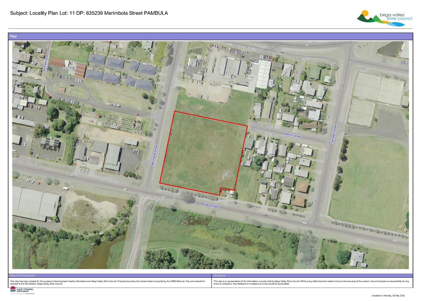
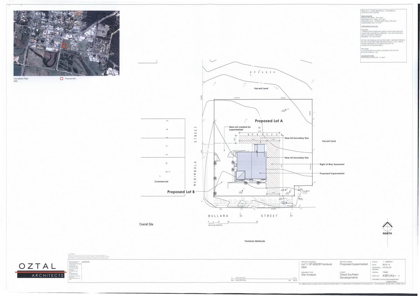
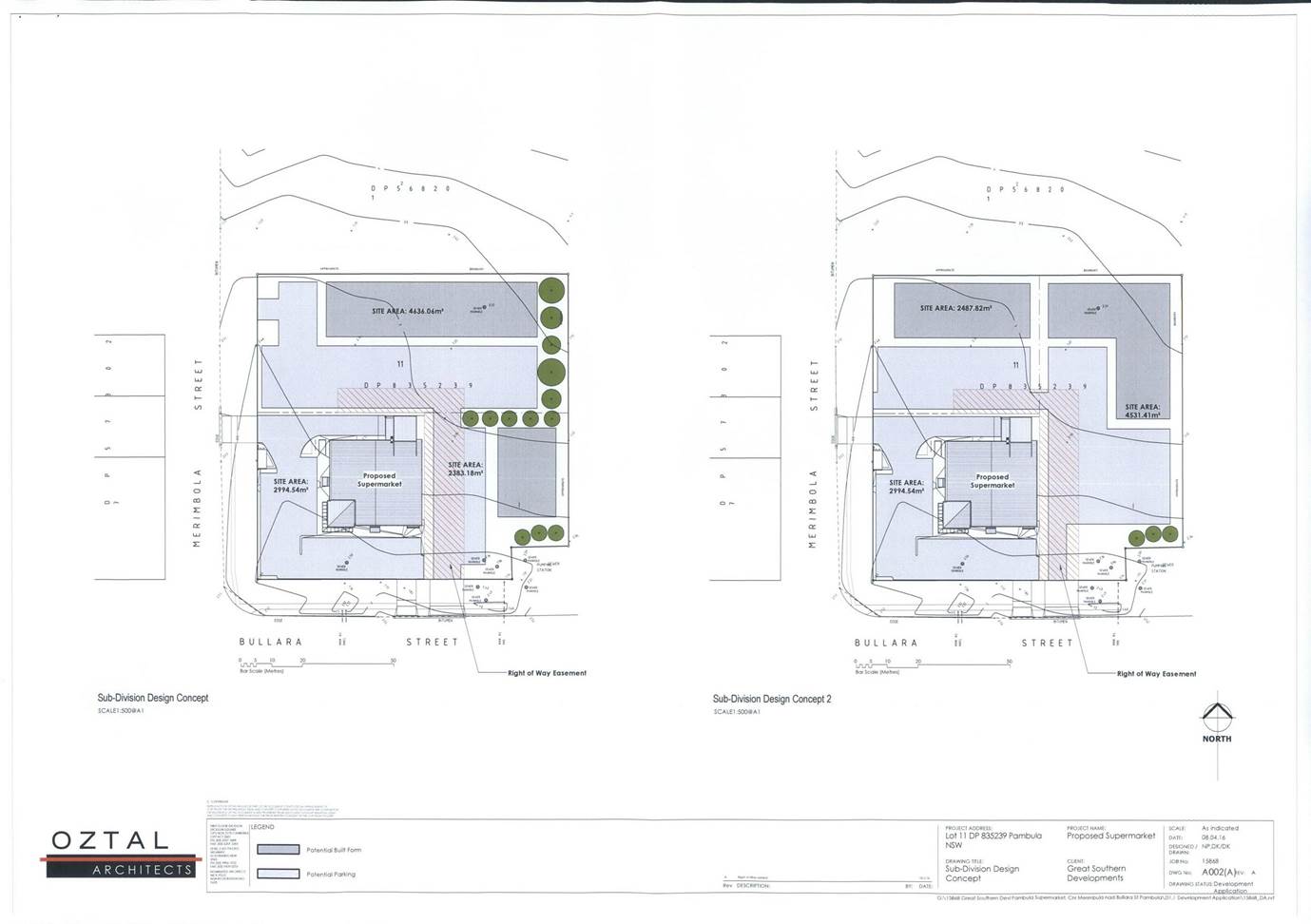
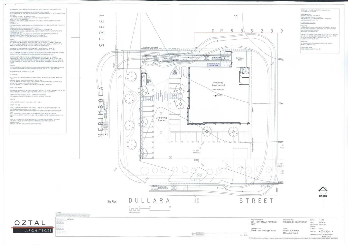
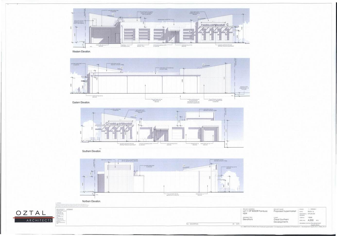
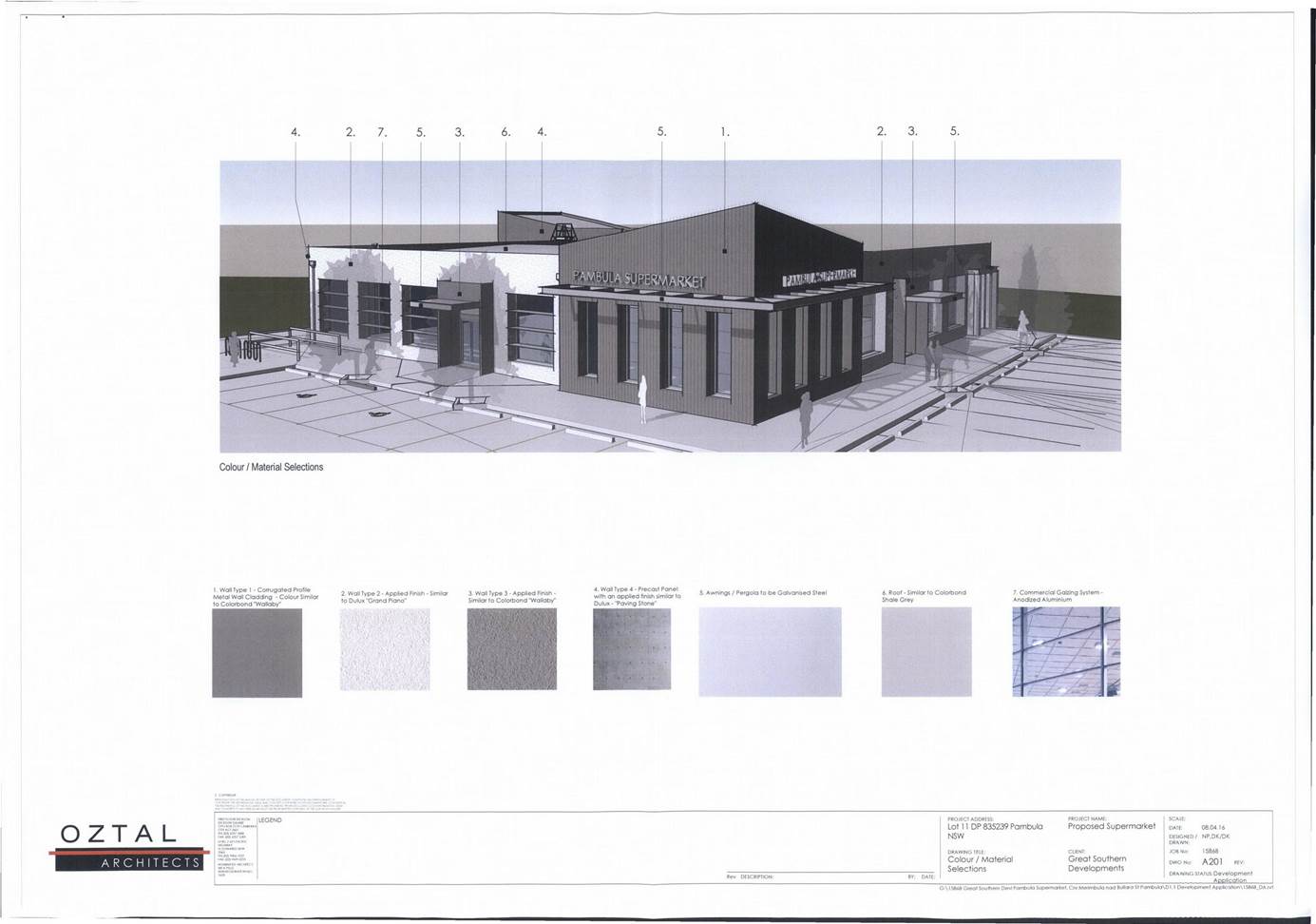
|
Council
|
20 July 2016
|
|
Item 8.8 - Attachment 2
|
Draft Consent Conditions
|
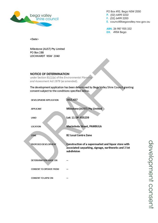
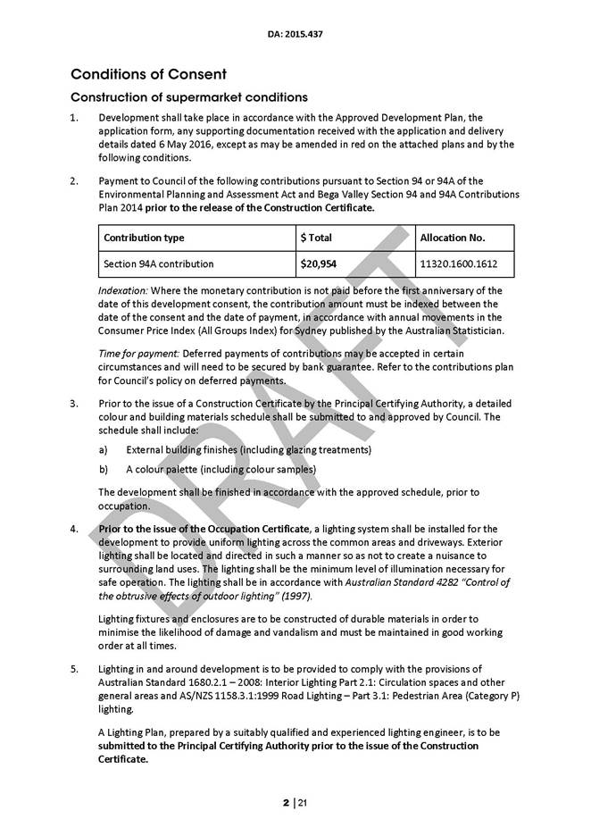
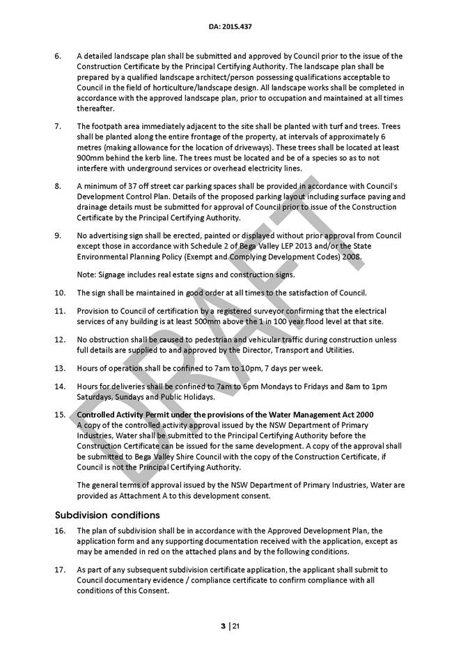
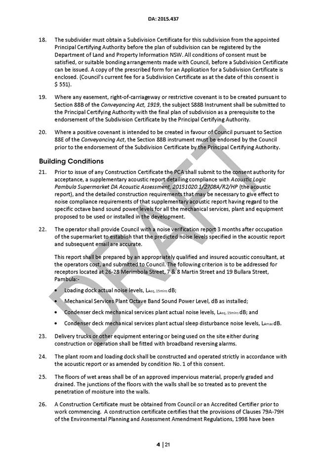
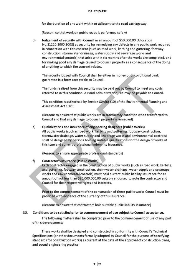
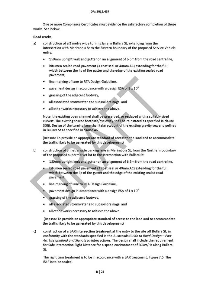
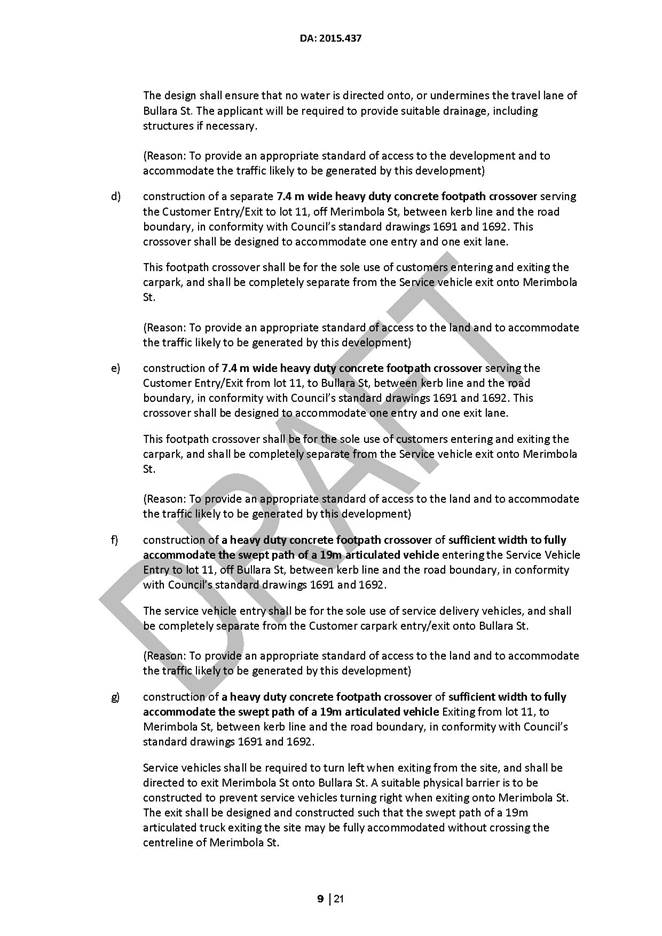
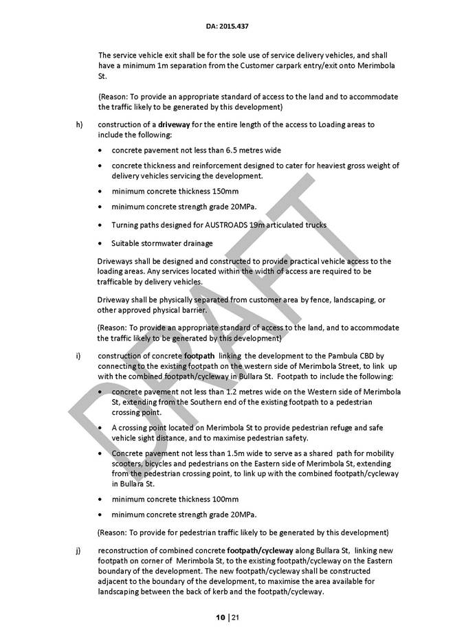
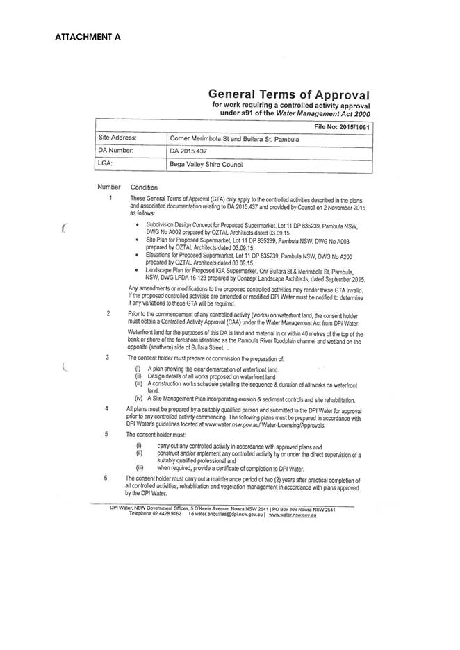
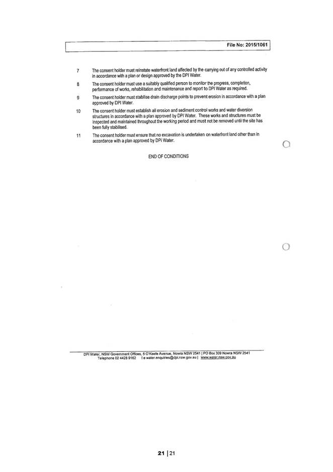
|
Council
|
20 July 2016
|
|
Item 8.8 - Attachment 3
|
Amended access arrangements
|
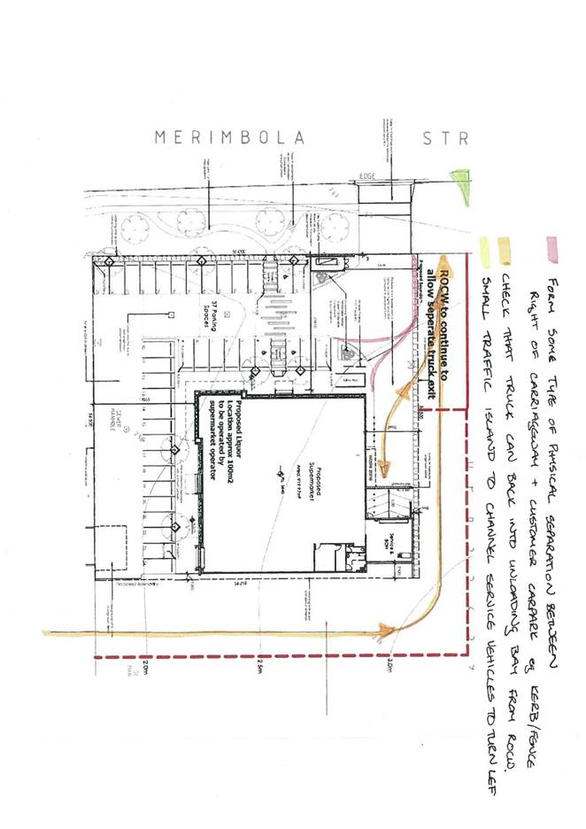
Staff Reports – Community, Culture and Leisure (Liveability)
20 July 2016
In accordance with
Council’s Code of Meeting Practice (2011), this section of the agenda
will be chaired by Cr Tapscott.
9.1 Access
Advisory Committee.............................................................................. 158
9.2 Council
Grants Review...................................................................................... 168
9.3 Halls
Maintenance Funding 2016/17................................................................ 176
9.4 Sportsground
Facility Management Plans........................................................ 179
9.5 Quarterly
Community Project Proposals Summary.......................................... 315
|
Council 20 July 2016
|
Item 9.1
|
9.1. Access
Advisory Committee
Under
section 355 of the Local Government Act 1993 Council appointed an Access
Advisory Committee to provide advice and guidance on issues related to access
across the Shire. This report provides an update on the successes of the
Committee over the past two years, a request for extension of tenure and
request for a Motion to be submitted to the Local Government NSW Annual
Conference.
Director Community, Relations and Leisure
Background
The current Access Advisory Committee has been in
place for approximately two years, however Council has had a Committee for more
than 20 years. The role of the Committee is outlined in the Access
Advisory Committee Guidelines adopted by Council in 2014 which states:
“The
Bega Valley Shire Council Access Advisory Committee is a formal committee of
Council that operates to assist Council in the development of strategies to
reduce barriers and increase access to Council premises and public buildings
for the residents within Bega Valley Shire. The committee also looks to provide
advice and recommendations on Council policy and liaises with key stakeholders
throughout the Shire.
The
Access Advisory Committee advises and makes recommendations to Council on matters
relating to access issues for people with disabilities as defined by the
Disability Discrimination Act. The committee shall also provide advice and make
recommendations to Council on matters relating to general accessibility of
facilities within the Shire, not only in relation to people with a disability,
but also for older people, parents with prams and other community members that
will benefit from ease of access. The Committee shall have a strategic focus,
liaising with Council on a range of accessibility and inclusion issues within
the Shire.”
This report is presented to highlight the work of the
Access Advisory Committee, seek an extension to the tenure of the current
Committee and propose a Motion for the upcoming Local Government NSW Annual
Conference.
Issues
Legal
The Access Advisory Committee is appointed under section 355
of the Local Government Act 1993.
Strategic
The Access Advisory Committee undertook a strategic planning
session at the start of 2016 and identified a number of priorities it wanted to
work on with Council throughout 2016. The strategic objectives were as follows:
· Update Committee
Guidelines
· Access to
commercial premises
· Promotion and
raising awareness; and
· Accessible tourism
promotion.
Following this session and in discussion with officers, the
Committee resolved to submit a Motion to Council, which it would like tabled at
the NSW Local Government Annual Conference in October 2016.
The proposed Motion is attached titled “Planning
requirements for improved access for people with a disability”. In
essence the concern of the Committee, as outlined in the supporting notes, is
there needs to be improved triggers for works that improve access to commercial
properties. The Committee believe the current triggers, which relate to a
change of use or the value of works, are insufficient.
Operational
Plan
Council's Community Strategic Plan, Under the Themes:
A Liveable Place, It states:
L3 Demonstrates respect and inclusion: We are a
harmonious community where everybody is welcomed, respected and diversity is
celebrated.
An Accessible Place, it states:
A2 Facilities and services: Our infrastructure, facilities
and services are strategically planned, located, designed and maintained to
meet our local and visiting community needs.
Social
/ Cultural
In general, Council has dissolved all 355 committees in the
months before the September 2016 local government elections, these committees
will be reformed committees under Resolution of the new Council.
Unlike other 355 Committees (i.e. General Halls Committee),
the current membership of Access Advisory Committee has been in place for two
years, not four. Given the status of a number of matters raised during the
Committee's strategic planning process, officers are seeking a short extension
of the tenure of the group through to the end of the 2016.
It is proposed that December 2016 would be the last meeting
of this Committee. Officers would present a further report in the first half of
2017 to Council regarding the formation of a new Committee. A full
recommendation from the Committee is attached for Council’s
consideration.
Consultation
The Access Advisory Committee provides a key point of
reference for Council in seeking advice and feedback regarding the development
of public infrastructure throughout the Shire. The Committee have provided
input into a number of issues and projects including:
· boat ramp designs
and development at Mogareeka and Kianniny
· the Tura Marrang
Library and Community Centre
· footpath issues
around the Shire
· Tathra Headland
trail proposal
· accessible tourism
opportunities
· beach access
opportunities at Pambula Beach, Bermagui and Merimbula
· accessible tourism
opportunities and promotion
· the Bega Valley
Commemorative Civic Centre
· commercial and
retail shop access issues
· CBD master
planning (Spiire plans)
· Lake Curalo path
· Bar Beach and
Pambula River Mouth redevelopments
· picnic table
design and locations
· disabled car park
misuse
· wheelchair
basketball day at Bermagui
· coastal access
consultation
· amenities at
Kisses Lagoon in Bega
· accessible
playgrounds at Ford Park, Merimbula and Bega Park; and
· public toilet
access audit for Spinal Cord Injury Australia.
Financial
and Resources
The Access Advisory Committee has a notional allocation of
$20,000 per annum to contribute towards access issues identified throughout the
year. In 2015/16 this was used to facilitate and construct footpath repairs in
Merimbula and Pambula, as well as assist with some of the cost of works
outlined above.
Council currently has before it
a proposal to move this notional allocation into a grants program run by the
Committee to address access issues.
|
Funding source
|
|
Amount
|
|
Council
|
$
|
20,000
|
Conclusion
The Access Advisory Committee have and continue to provide
input and advice into Council works and policies, thus providing better
outcomes for the community at large, but in particular for people with a
disability, the elderly or those with limited mobility.
Attachments
1. Extension
of Access Advisory Committee tenure recommendation
2. LGNSW
Annual Conference Motion - Planning requirements for improved access for people
with a disability
3. Access
Advisory Committee Project Photos
|
Recommendation
1. That
Council note the successes and work of the Access Advisory Committee.
2. That
Council resolve to submit the following Motion to the Local Government NSW
Annual Conference 2016 for consideration by the assembly:
“That
LGNSW advocate on changes to relevant legislation and/or regulation,
including identifying resources, that require commercial operators to upgrade
access and associated facilities to and within premises when any
improvements/works/changes are undertaken, and that such works should include
upgrade of the facilities available to the public in such buildings; and
That
LGNSW advocate to the State Government, possibly through the State Disability
Advisory Council, to develop an education and awareness program on the
benefits of improving access to commercial premises and associated
facilities.”
3. That
Council approve a three month extension to December 2016 of the Section 355
Access Advisory Committee and its current membership being as follows:
· Mr Ronald
Finneran OAM (Chairman)
· Mr Chris Sparks
· Mr Colin Dunn
· Mr Graham
Carmody
· Ms Jennifer
Dessens
· Mr John Reynolds
· Mr Nathan
Johnston
· Ms Rosemary
Oates; and
· Ms Sue Thomas.
|
|
Council
|
20 July 2016
|
|
Item 9.1 - Attachment 1
|
Extension of Access Advisory Committee tenure recommendation
|
|
Council
|
20 July 2016
|
|
Item 9.1 - Attachment 2
|
LGNSW Annual Conference Motion - Planning requirements for
improved access for people with a disability
|
|
Council
|
20 July 2016
|
|
Item 9.1 - Attachment 3
|
Access Advisory Committee Project Photos
|
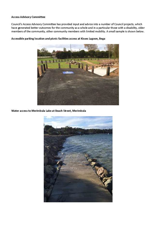
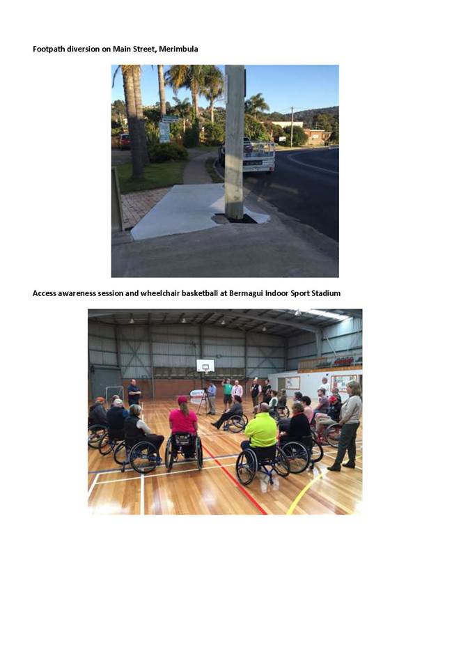
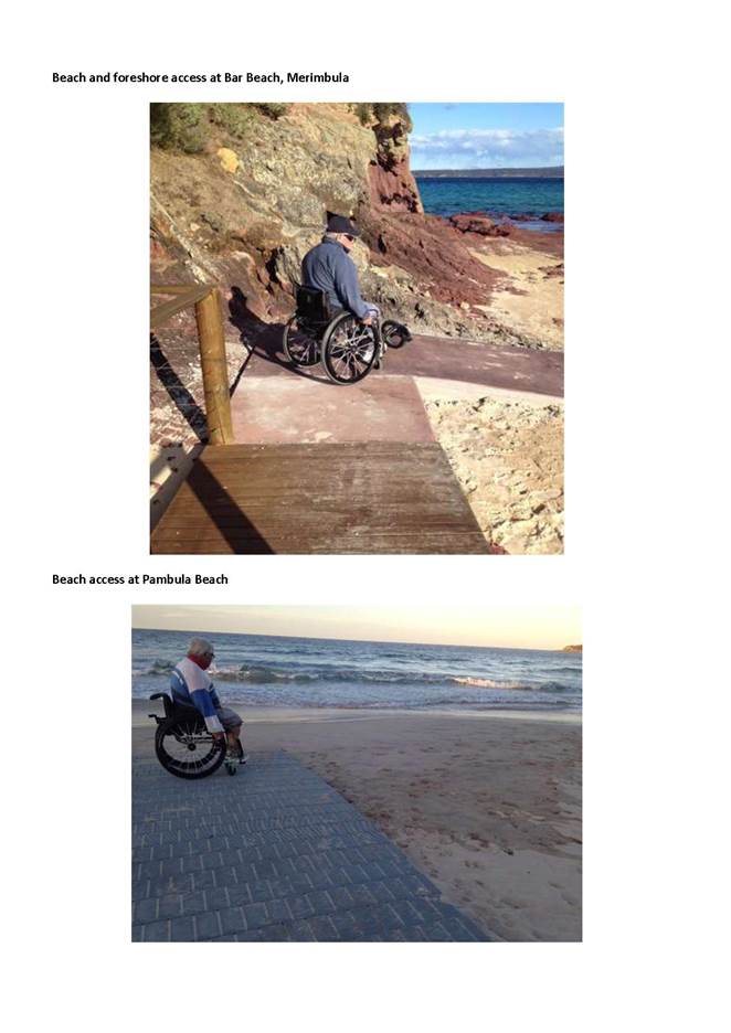
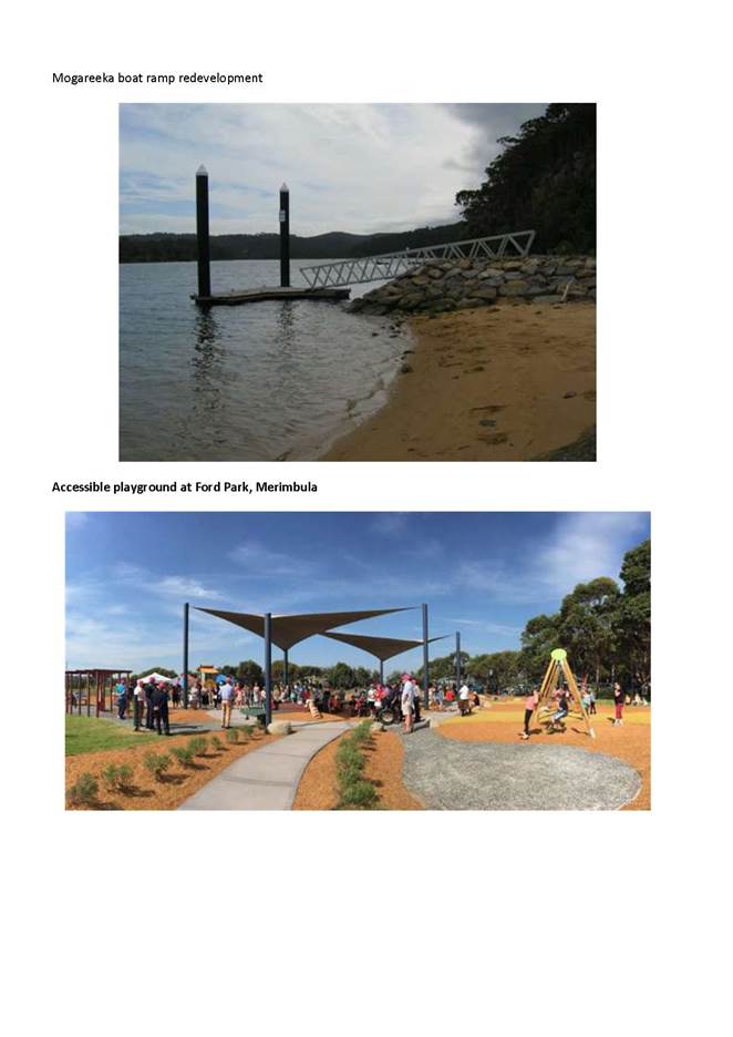
|
Council 20
July 2016
|
Item 9.2
|
9.2. Council Grants
Review
An internal
review of grants provided by Bega Valley Shire Council to community groups and
organisations has been undertaken. The review has identified a number of
changes that could be made to improve this process further and these are
presented for Council’s consideration.
Director Community, Relations and Leisure
Background
Officers have undertaken a review of grants that are
offered and provided by Bega Valley Shire Council (BVSC) to the community
across a number of Council service areas.
The original scope of the review sought to focus on
‘grants’ only; however as the review progressed other elements
emerged that needed to be considered, such as allocation from the 356 Financial
Assistance program, ongoing partnerships arrangements and budget allocations.
Issues
Legal
The Local Government Act 1993
(NSW) (the Act) provides the legislative mechanism to allow Councils to provide
funds to the community for the purposes of exercising its functions.
Specifically the Act states in section 356 that:
“(1)
A council may, in accordance with a resolution of the council, contribute money
or otherwise grant financial assistance to persons for the purpose of
exercising its functions…”
Strategic
Policy
There are a number of
elements of the current BVSC grants program that are working well. These are
summarised below:
§ Community activities and services are being
funded – A significant amount of money is given out each year to support
many important, interesting and valuable activities across the Shire that add to
the wellbeing and vibrancy of the community. This funding leverages community
input and additional funding from other sources to increase the capacity of the
projects supported for community benefit.
§ Environment grants – These were recently
reviewed and have a very thorough procedure linked to the program. These also
leverage considerable community input and endeavour and in some cases
additional external funding.
§ Administration support to the Club Grant
programs.
There
are however a number of issues that face the current granting process that need
to be resolved, including:
§ Inconsistent documentation and procedures
§ Inconsistent requirements for acknowledging
Council
§ Inconsistent acquittal procedures
§ Over subscription of some grant programs
§ Publicly available information of past grant
recipients and Council’s grant program generally; and
§ Recurrent requests – Many groups apply or
seek financial support for ongoing programs.
A
revised procedure needs to address these issues, which could be done as
follows:
§ Create generic guidelines and/or
requirements covering all grants provided by Council. This would
include things such as a common acquittal process, acknowledging Council (and
other partners), linking to Council strategies and plans, outlining how to deal
with in-kind support and the value of volunteer time, requirements of matching
funds or not, legal status of recipients, broader expectations of being a grant
recipient etc.
§ Create a standardised application form
with grant specific requirements being covered in a schedule specific to each
grant program as required. This standardised form would also allow for a
consistent look and feel of the grants documentation. This together with the
generic guidelines would aim to simplify the process for applicants.
§ Have key application date or dates per
year and publicise these. Further work with grant administrators is
required to determine whether one date or multiple dates per year is the most
appropriate. The timing could be set so as not to conflict with other community
granting bodies or align to budget allocations. Reimbursements would need to
remain as required.
§ Explore the potential of providing
multi-year grants to activities that regularly occur and have a strong
past history of delivery. This can provide certainty to event organisers and
reduce volunteer and officer time in annual application processes.
§ Index grants annually in line with their
source. i.e. if grants are from General Funds or a levy then they
should be indexed by the same rate as the source. Grants need to keep pace with
the increases in cost of undertaking activities.
§ Create a grants web page on
Council’s web site that tracks all grants provided to the
community over an agreed period (3 to 5 years). This acts as demonstration of
Council’s commitment to supporting community activities, a source of
information for perspective applicants on the types of things Council will fund
and a source of information for other funding bodies when assessing their own
grant rounds.
Operational
Plan
The following areas of the
2012-2017 Community Strategic Plan are relevant to the BVSC grants program:
L1
Wellbeing and safety: We feel safe in
our community, with access to health, social and community services, and have
appropriate community infrastructure provided to support a high quality of
wellbeing and safety.
E1
Growing our local businesses: We have
increased business capacity and opportunities, generating ongoing economic
development.
S1
Valued natural environments: The
natural environment and ecosystems are appropriately protected and enhanced.
S2
Sustainable communities: Our
community has the services, opportunities and support to live sustainably.
A2
Facilities and services: Our
infrastructure, facilities and services are strategically planned, located,
designed and maintained to meet our local and visiting community needs.
Social
/ Cultural
Mumbulla
Foundation
BVSC
has a unique relationship with the Mumbulla Foundation (the Foundation) whereby
it provides a grant to the Foundation who in turn match it and make the total
sum available to the community. The Foundation has recently sought an increase
in the grant from $25,000 to $35,000 in addition to the $5,000 administration
support grant that they also receive. Any funds not used for administration are
currently put into the grant pool.
The relationship with the
Foundation adds value to the Council grant funds by essentially doubling what
is available to the community. It is unlikely in the current financial
environment that Council would be in a positon to double funds if it offered
directly a similar grant program. The downside is that the Council has minimal control
over the allocation of the funds through this process.
In 2015/16 the Foundation
funded 34 organisations to the value of $74,407. Some of these organisations
and projects may not otherwise have received funding. Council officers provide
some support, but administration is predominately done by the Foundation
volunteers.
Access Advisory Committee
Council has a Section 355
Access Advisory Committee that advocates on issues relating to access across
the Shire. The Committee is made up of volunteer members who advise Council on
issues related to access, and in particular on physical access to community
facilities and buildings. The key goal is to make Bega Valley Shire a better
place for residents or visitors who are elderly or have a disability.
Creating an Access Grant
program from funds currently budgeted (see below for specific proposed
allocation) could assist in ‘fixing’ access issues across the
Shire, by allowing the committee to call for worthwhile projects from the
community. This has a two pronged affect in that it raises the profile of the
Access Advisory Committee and addresses access problems.
Consultation
Consultation has primarily
been done internally through convening an Internal Grants Review Working Group
chaired by the Director Community, Relations and Leisure and included Manager
Environment Services, Strategy and Business Services Executive Assistant, Manager Community, Culture and Information,
Strategic Planning Coordinator, Manager Waste and Recycling and Events
Coordinator.
An external grants roundtable
was held with Bendigo Bank, IMB Bank, Club Grants and Mumbulla Foundation
representatives. This was a very positive meeting and the local community
funding bodies are keen to share information and work together, whilst meeting
their organisation needs.
The Access Advisory Committee
has also been consulted on the Access Grants proposal.
Financial
and Resources
The community grants
environment
The community grants
environment has changed over time. There are currently a number of local community
grant funding opportunities that historically have not been available. These
include grants from organisations such as: Mumbulla Foundation; Bendigo
Community Bank; IMB Bank; various categories of Club Grants and Southern Phone
(a three year program with one year to run). Many community groups and
activities rely on these grants on an annual basis to deliver the activities
and services run in the Bega Valley Shire. There are also many State and
Federal grants to support local activities (i.e. NSW Community Partnerships
Grant and Commonwealth Stronger Communities Program).
Grant funds
In 2014/15 Council provided
$230k to various groups across the Shire through 12 grant programs. In 2015/16
$295k was budgeted for distribution with the largest proportion being from 356
Financial Assistance Fund.
In 2015/16 other
organisations also gave out large amounts of funds including the Mumbulla
Foundation that distributed $74k, category 1 Club Grants provided $91k, Bendigo
Bank Community Grants distributed $102k in sponsorship, grants and donations
(source: 2015 Annual Report); Southern Phones provided $25k; and IMB Bank
distributed $66k (noting that this includes amounts to other Shire’s on
the Far South Coast (source: IMB website media release)). Together these funds
from Council and other organisations add up to more than half a million dollars
being provided to various community groups and organisations across the Shire
in 2015/16, not including the many State and Federal Government grants programs
announced.
Council non-cash support
In addition to
‘cash’ grants provided by Council to organisations, there is a
significant amount of in-kind contribution or non-cash support made to
activities that occur around the Shire, such as ANZAC Day and Remembrance Day
marches, Merimbula New Years Eve community event and fireworks, Eden Whale
Festival, MotorFest, Bermagui Seaside Fair, Sculpture of the Edge, etc.
particularly by Council’s works teams in getting reserves and townships
ready and through clean up and waste collection. This includes things such as
road closures, extra cleaning and site preparation, rubbish removal,
installation of barriers and so on.
These non-cash contributions
are an important part of supporting events to be viable; however come at a real
cost to Council. This real cost has to be borne by budgets that are ear marked
for other activities. Some tracking has occurred in 2015/16; however more work
is required to get an accurate picture of this contribution from across the
organisation and longer term these costs either need to be in addition to
existing budgets or the costs passed onto who ever requests the service.
2015/16 Council grants
|
Source
|
Grant program
|
Annual allocation
|
CSP area
|
|
Grants from levies, rate variations
or external partners
|
Community Environmental Grants Program – Levy
|
$40,000
|
A sustainable place
|
|
Waste Community Assistance Program – Levy
|
$30,000
|
A sustainable place
|
|
Local Heritage Assistance Fund – External partner
|
$20,000
|
A sustainable place
|
|
Southern Phones Mayoral Grant – External partner (2nd
year of three year program)
|
$25,000
|
Multiple CSP areas
|
|
Sub total
|
|
$115,000
|
|
|
Grants from General fund
|
356 Financial Assistance Grants*
|
$112,000
|
Multiple CSP areas
|
|
Mumbulla Foundation Triennial Grant
|
$30,000
|
A liveable place
|
|
South East Arts Triennial Grant
|
$22,888
|
An enterprising
place
|
|
National Youth Week Grants
|
$5,000
|
A liveable place
|
|
Seniors Weeks Grants – Linked to Seniors Festival
|
$5,000
|
A liveable place
|
|
Tertiary scholarships – Linked to National Youth Week
|
$5,000
|
An enterprising
place
|
|
Young women's scholarship – Linked to International
Women’s Day
|
$500
|
A liveable place
|
|
Sub total
|
$180,388
|
|
|
Grand total
|
$295,388
|
|
* 356 Financial Assistance Grants includes the
following elements:
§ Reimbursements to community groups for some
fees and charges
§ Festival and events funding
§ South East Regional Academy of Sport
§ Sporting and cultural representation
§ Backfill for oversubscribed grant programs
§ Acquisitive prize for Sculpture on the Edge
§ Unforeseen or unanticipated community funding
requests
Proposed
grants programs for 2016/17
As
part of the grant review, the 2016/17 budget development process and in
discussion with Councillors it became clear that there needed to be clarity on
the grant programs that should be available and the value of each of those
programs.
To
address this officers have identified proposed grant programs based on past
grant provision and areas of regular request. The allocation of the part of the
Southern Phone annual dividend towards the grants program allows for some
modest growth in grants available and takes pressure off the General Fund. The
use of part of the expected dividend allows some yearly fluctuations without
impacting on the grants program. The dividend figure used is based on dividends
over the past few years, acknowledging that if those dividends were to change
the grant programs would need to be reconsidered in light of a changing
financial position and amended, via budget review, accordingly. It also
provides an opportunity for Southern Phones to badge or promote themselves
particularly in the events category, which they request although this is not
mandatory.
The
grant programs and their funding source are listed below for Council’s
consideration.
|
Funds source
|
Grant program
|
Proposed allocation
|
CSP area
|
|
Grants from levies, rate variations or
external partners
|
Community
Environmental Grants Program – Levy*
|
$50,000
|
A
sustainable place
|
|
Waste
Community Assistance Program – Levy
|
$30,000
|
|
Local
Heritage Assistance Fund – External partner
|
$20,000
|
|
Southern
Phones Mayoral Grant – External partner (final year)
|
$25,000
|
Multiple
CSP areas – Mostly liveable place
|
|
Sub total
|
$125,000
|
|
|
Grants from General fund
|
Mumbulla
Foundation
|
$30,000
|
A liveable
place
|
|
Economic
Development grants – To support implementation of the Economic
Development Strategy
|
$25,000
|
An
enterprising place
|
|
South East
Arts – Council’s contribution to a regional arts organisation
covering South East NSW and is part of a triennial agreement.
|
$25,000
|
|
Access
projects – As part of the 355 Access Advisory Committee activities
|
$20,000
|
An
accessible place
|
|
Seniors and
Youth Weeks grants – Funds activities to celebrate national Youth Week
and Seniors Week.
|
$10,000
|
A liveable
place
|
|
Tertiary
Education Scholarships – Small grants to support young people study in
the Shire.
|
$5,000
|
An
enterprising place
|
|
|
Young Women
- Small grant to recognise the achievements of young women in the Shire.
|
$500
|
A liveable
place
|
|
Sub total
|
$115,500
|
|
|
Grants
from Southern Phones annual dividend
|
Community
festivals and events
|
$60,000
|
An enterprising
place
|
|
South East
Region Academy of Sports – Annual allocation to support local young
people excel in a sporting pursuit.
|
$14,000
|
A liveable
place
|
|
Reimbursements
– Community DA and cemetery fees etc.
|
$12,000
|
An
accessible place
|
|
Sporting and
Cultural representation – Small amounts to assist with interstate or
national representation
|
$2,500
|
|
Mumbulla
Foundation increase – Response to request from Foundation
|
$10,000
|
A liveable
place
|
|
Seniors
week increase – Due to annual oversubscription
|
$5,000
|
|
Sub total
|
$103,500
|
|
|
Grand Total
|
$344,000
|
|
*
Increase was resolved by Council on 6 April 2016.
Community festivals and
events
Further work is required
regarding the breakdown of the community festivals and events grant program so
that the amounts available per application are clear. It may also be relevant
to look at start-up funds where there is
an initial grant, but no ongoing commitment. The
detail on this program will be presented to Council at a later date if the
recommendations are accepted.
In addition, it would be
worthwhile bringing organisers of community festivals and events together to
better understand their needs and requirements and how these fit with Council
priorities and available funding.
Community project
proposals
Council has developed a
process for formally receiving and assessing community project proposals. This
process has been in place for approximately nine months and has elicited a
range of submissions seeking only permission to undertake works to aspiration
projects worth millions of dollars. Council has previously allocated monies
from existing budgets where project proposals aligned to planned works and from
the Southern Phones Dividend proceeds. In some cases funds were not required or
were provided by the project proponent.
Community project proposals
have not been included as a grant program in this proposal. It is important to
assess each proposal on its merits and determine the most appropriate funding
programs which may be other levels of government. On occasions where no other
grants are suitable or external avenues have been exhausted, Council may need
to note the merits of the project/s and ‘park’ the proposal until
future funds (either internal or external) become available.
Conclusion
Council
provides significant amounts of funding to a range of organisations and groups
across the Shire, who in turn are providing valuable activities and services
for residents and visitors.
The
provisions of the Local Government Act 1993 (NSW) allow Council to provide
funds to others to exercise its functions. The key to the provision of Council
funds should be to assist in the delivery of Council priorities captured in its
Operational and Delivery Plans or other strategic documents.
If
adopted the changes outlined in this report would represent a major change to
the management of grants programs for Council. It may take two years to
implement a new structure due to existing grant timelines and ability to
undertake the next level of work.
Attachments
Nil
|
Recommendation
1. That
the report be noted.
2. That
Council use the Southern Phones annual dividend towards a grants program.
3. That
Council increase the Mumbulla Foundation allocation by $10,000 per annum and
increase the seniors week grants by $5,000 per annum.
4. That
Council implement a revised grants program that includes grant as outlined in
the table below, and that these grants be indexed at the
same rate as their source funds.
|
Grant Program
|
Proposed Allocation per annum
|
|
Accessible Place Grants
|
Access Grants
|
$20,000
|
|
Community Group fees
& charges reimbursement Grants
|
$12,000
|
|
Sporting & Cultural
representation Grants
|
$2,500
|
|
Enterprising Place Grants
|
Community Festivals &
Events Grants
|
$60,000
|
|
Economic
Development grants
|
$25,000
|
|
South East Arts Grant
|
$25,000
|
|
Tertiary Scholarship
Grants
|
$5,000
|
|
Liveable Place Grants
|
Mumbulla
Foundation
|
$40,000
|
|
Seniors Grants
|
$10,000
|
|
South East Regional
Academy of Sports Grant
|
$14,000
|
|
Youth Week Grants
|
$5,000
|
|
Young Women’s
Scholarship
|
$500
|
|
Sustainable Place Grants
|
Community
Environmental Grants Program – Levy
|
$50,000
|
|
Waste
Community Assistance Program – Levy
|
$30,000
|
|
Local
Heritage Assistance Fund – External partner
|
$20,000
|
5. That
Council convene a roundtable meeting with community festival and event providers.
6. That Council
revise its grants program procedures to address the findings noted in this
report.
|
|
Council 20 July 2016
|
Item 9.3
|
9.3. Halls
Maintenance Funding 2016/17
The S355 General Halls
and Buildings Committee recommendations for the expenditure of the Hall
Maintenance funding 2016/17 are presented for Council’s endorsement.
Director Community, Relations and Leisure
Background
There are 19 community halls across the Shire, 18 of which
are managed by community committees and volunteers with the assistance of
Council staff. Council provides an annual budget allocation to address
maintenance issues and works at these halls. This allocation supplements the
ongoing operations and maintenance that is funded through fees and charges
collected for individual halls.
Projects are determined through discussion at the S355
General Halls and Buildings Committee meeting. All halls have a delegate
to the Committee and they present projects for consideration. This process has
been in place for several years and is well supported by the individual hall
management committees.
In 2015/16 nine projects were
identified for funding from the maintenance budget. These included termite
treatments at six halls, the replacement of windows at Brogo and Wolumla Halls,
and the relining of the internal walls at Tarraganda Hall.
In 2016/17 the adopted budget for the maintenance/renewal of
community halls is $70,000.
The General Halls and Buildings Committee met on the 24 May
2016, and considered project proposals from the individual hall committees in
terms of affordability and achievability. The proposed projects met at least
one of the following criteria:
§ Works need to be completed to avoid
ongoing harm, damage or deterioration; and
§ Works are required to reduce
ongoing maintenance/repair.
As in previous years a portion of the maintenance funding is
held back to address unscheduled maintenance across the halls.
The recommendations of the Committee for the
attribution of maintenance funding in 2016/17 are as follows:
|
Hall
|
Project
|
Amount
|
|
Cobargo
|
Re-stump approx. 40 stumps and level floor
|
$12,600
|
|
Wyndham
|
Re-stump approx. 15 stumps and level 4
|
$7,300
|
|
Towamba
|
Repairs to roof identified by independent
assessor
|
$4,000
|
|
Kiah
|
Floor repair and sanding
|
$6,000
|
|
Tarraganda
|
Bollards and extension of concrete area at hall entry
(*2,000)
|
$3,000
|
|
Wolumla
|
Toilet renovations and repair (*2,000 committee,
$500 Friends of Wolumla Hall)
|
$7,500
|
|
|
Responsive Maintenance contingency
|
29,600
|
|
|
TOTAL
|
$70,000
|
* indicates committee
contribution in addition to maintenance funding allocation
Issues
Legal
The General Halls and Buildings Committee is appointed under
section 355 of the Local Government Act 1993 (NSW).
Operational
Plan
The management of Council’s community halls is
identified in Council’s Delivery Plans 2012 – 17 and Operational
Plan 2016-17. The specific strategic actions are;
A2.3.1 Consolidate partnerships with community groups in
managing and maintaining some community assets such as halls, playgrounds and
sporting grounds/facilities; and annual activity, and
A2.3.1.1 Maintain and manage Council's Community Halls in
partnership with Hall Committees.
Asset
Council’s halls are managed and operated by volunteer
committees who coordinate maintenance and utilisation. Council’s adopted
Buildings Asset Management Plan provides the framework for the management of
the facilities. Individual facility management plans (FMP) are in place for all
halls.
Social
/ Cultural
Council’s community halls play an important role as
central points for social and cultural activities in towns and villages across
the Shire. Partnerships developed with community members to manage and care for
these assets have multiple benefits and support community wellbeing.
Consultation
The General Halls and Buildings s355 Committee is
Council’s peak advisory body in relation to the management of these
important community facilities. Committee members are aware of the state of
various facilities and the decision making process is as informed as
possible.
A representative from each individual hall committee was
given the opportunity to present their project to the General Halls and
Building Committee including photos and estimates of costs for their projects.
Quotes on works from accredited contractors were sought by Council staff to
inform the Committee and estimates were made where these were not finalised.
The Committee then made their recommendations based on the criteria outlined
above and the level of funding identified in the 2016/17 budget. The Committee
were unanimous in their recommendations.
Financial
and Resources
|
Funding source
|
|
Amount
|
|
Halls Maintenance and
Renewal
|
$
|
70,000
|
The
oversight management of the projects will be undertaken by the Council staff in
consultation with the individual hall committees and forms part of their annual
work plan.
Conclusion
Community halls provide a significant social and
cultural benefit to the communities and are well managed by Community
Committees, with the support of Council staff. The General Halls and Buildings
Committee is an effective forum for participatory decision making and resource
allocation. The committee voted unanimously to put the recommendations forward
to Council for endorsement.
Attachments
Nil
|
Recommendation
1. That
the report be noted.
2. That
Council endorse expenditure from the 2016/17 Halls Maintenance Funding as
follows:
|
Hall
|
Project
(*indicates
committee contribution in addition to maintenance funding allocation)
|
Amount
|
|
Cobargo
|
Re -stump approx. 40 stumps and level floor
|
$12,600
|
|
Wyndham
|
Re –stump approx. 15 stumps and level 4
|
$7,300
|
|
Towamba
|
Repairs to roof identified by independent
assessor
|
$4,000
|
|
Kiah
|
Floor repair and sanding
|
$6,000
|
|
Tarraganda
|
Bollards and extension of concrete area at hall
entry (*2,000)
|
$3,000
|
|
Wolumla
|
Toilet renovations and repair (*2,000
committee, $500 Friends of Wolumla Hall)
|
$7,500
|
|
|
Unscheduled maintenance and contingency
|
29,600
|
|
TOTAL
|
$70,000
|
|
|
Council 20 July 2016
|
Item 9.4
|
9.4. Sportsground Facility
Management Plans
Facility
Management Plans have been developed for Council’s sportsgrounds where an
active site committee is in place and represented on Council’s S355
Sportsgrounds Committee. The plans are being reported to Council for adoption.
Director Community, Relations and Leisure
Background
There are currently 15 sportsground sites managed by Council
across the Shire, with volunteer committees in place at many sites working in
partnership with Council. There is an increasing need to establish formal
management and operational plans to ensure fit-for-purpose, safe, and
accessible sporting facilities are provided in the most efficient manner
possible across the Shire.
Sportsgrounds include a range of infrastructure
including: playing surface/s for a variety of sports; lighting;
pavilions; toilets; parking; seating; and shelters. These are managed and
maintained by a mixture of Council, community committees and user groups.
The management and operation of sportsgrounds incurs a
number of expenses such as: electricity; water; cleaning; and mowing. There are
also other regular (i.e. seasonal and annual) maintenance tasks and asset
inspections that should be undertaken to ensure the facilities are in a fit for
purpose condition. For this to happen it is important there is an operations
and planning tool so all tasks required for the facilities to operate are
understood and suitably resourced.
A Facility Management Plan (FMP) provides direction for the
planning, management, maintenance, operation and use of sportsgrounds and
associated facilities so that the users and community’s needs are best
met. It also provides an opportunity for future aspirational goals to be
identified.
Council commenced a process for the development of FMPs for
the sportsgrounds across the Shire in 2015. Sites with active sportsground
committees represented on the S355 Committee have been developed first (the
subject of this report) with the remainder of the facilities to follow. It
should be noted that while Bega Sporting Complex is identified as a regional
facility, an FMP has not been finalised for that site as there is not an active
site committee operating.
Officers have worked very closely with each of the active
site committees and the S355 Sportsgrounds Committee in the development of the
FMPs.
Issues
Legal
As part of workplace health and safety requirements, and
overarching public liability duty of care, there is legislation and regulations
that come into effect in the operation and maintenance of sportsgrounds. Having
FMPs that identify the fundamental aims of provision, service levels and
responsibilities in delivering those service levels, is a key component of
delivering useable and safe facilities and reducing the likelihood of incidents
occurring. Each FMP includes a Facility
Risk Management Plan which
identifies potential risks, provides a risk rating based
on the likelihood and consequences should the risk event occur, and
outlines a risk treatment action.
The Local Government Act 1993 applies in relation to
procurement of services and also for use of public assets for commercial
benefit. This applies particularly in relation to the purchasing of goods and
services for the operation and/or maintenance of the sportsgrounds.
The Crown Lands Act applies where assets are located
on Council managed Crown Lands as is the case with a number of the
sportsgrounds.
Strategic
There are a number of Council Plans and
Policies that relate directly and indirectly to the development of the FMP.
They include:
· Community Strategic Plan (CSP)
· Asset Management Plan – Parks and Recreation 2015
(AMP)
· BVSC
Procedure – Community Project Proposals.
· BVSC
Specification Sports Ovals/Fields 2016
· Sportsgrounds
Condition Assessments 2016
The following objectives provide the framework for the
establishment and implementation of equitable and operational Sportsground
FMPs:
· Encouraging
community health and wellbeing through opportunities to participate in sports
and recreational activities.
· Providing
community facilities that are accessible to all community members.
· Providing
sportsgrounds that offer the best possible ‘fit-for-purpose’
facilities.
· Increasing
the multi-use potential of sporting and ancillary facilities to see sites are
adaptable and well used into the future.
Policy
Sportsground committees and their members operate under the guidance of
the following Council Policy and procedure documents:
§ Sportsground
Committee Guidelines;
§ Sportsground Committee Operations Manual;
§ Sportsground
Committee Purchasing Guidelines; and
§ BVSC
Code of Conduct.
Operational
Plan
The development of FMPs for Council’s sportsgrounds
links to the following ambitions and outcomes identified in the Bega Valley
Community Strategic Plan 2030:
Community Ambition A2: Facilities and services - Our
facilities and services are strategically planned, designed and maintained to
meet the community needs.
Outcome Area A2.3: Safe and well maintained sporting
fields, recreation areas and built facilities meet the cultural, recreational,
tourism and community service needs of all ages and abilities in our community.
Asset
The sportsgrounds that are the subject of these FMPs are
predominantly the sites identified as regional and district facilities in the
BVSC Parks and Recreation Asset Management Plan 2015 (AMP). They are situated
on a mixture of Council owned land and Council managed Crown Land.
The goal of asset management is to meet a required level of
service in the most efficient way through the operation, maintenance and
renewal of assets.
Council’s Parks and Recreation Asset Management Plan
(AMP) outlines a lifecycle management plan which details how Council will
manage and operate its assets (including sportsgrounds) at the agreed levels of
service. Council’s Asset Register and Asset Renewal Program are contained
in the AMP and identify assets at particular sportsgrounds including details of
the remaining life, renewal time and cost estimates. The asset inventory makes
some assumptions and generalisations to enable it to provide a Shire-wide
picture of recreation assets.
A key outcome of the AMP is that recreational assets are
financially sustainable. This requires Council to monitor and identify assets
in need of renewal, understand the cost and implications of upgrades, review
the levels of use and value of provision and, where need be, rationalise
assets.
Sportsground committees, Council officers, sports clubs,
contractors and other volunteers all play an important role through their
involvement in the care and maintenance of Council sportsgrounds, with the
responsible group for each task clearly outlined in the FMPs.
Social
/ Cultural
An active lifestyle and involvement in sport and
recreational activities provides physical and social health benefits.
Individual and team sports promote social cohesion, networking, development of
friendships and can improve social skills.
Many residents within the Shire participate in regular
organised sport as a player, administrator or spectator and as such
sportsgrounds are highly valued by the Bega Valley Shire community.
Historically there has been a very high level of volunteer involvement in
running many of these sites which has led to high community interest.
Importantly the FMPs clearly account for the value and worth
of volunteer inputs in the running of facilities through putting a commercial
value on the work undertaken by volunteers at each site, which would otherwise
have to be funded by Council and users.
Consultation
Thorough consultation with site representatives has been a
key aspect in developing and establishing the FMPs for sportsgrounds.
The FMPs identify individual asset types at each site and
from there each task required and the frequency to manage those assets. The
FMPs then identify the frequency of the tasks and who is best placed, capable
and responsible for undertaking those tasks. There have been numerous meetings,
site inspections and direct discussions in order for the most effective Plans
to be developed.
Drafts were developed and distributed to each site committee
to enable them the opportunity and time to engage the respective user groups at
each site in the process and collectively recommend any alterations they felt
necessary.
Once finalised the FMPs were reported to the S355
Sportsgrounds Committee. That Committee provided a unanimous recommendation on
4 April 2016 for the Plans to be reported to Council for adoption.
Financial
and Resources
In developing the resourcing component of the FMPs, the
operating and maintenance requirements have been identified along with asset
renewals and proposed capital upgrades. A key element has been acknowledging
the core strengths and capabilities of the different groups involved at each
site.
Identifying
responsibility reduces the possibility there will be ‘grey areas’,
duplicated effort or misunderstandings. Importantly it also provides an
opportunity to account for the value and worth of volunteer input in the
running of the facilities. A key element the FMP’s provide is a budgeting
tool that identifies the cost for each task required at the site and
consequently encourages the pursuit of efficiencies in the management of each
sportsground.
Operational plans and resource allocations are intended to
be adequate to meet the levels of service
required to deliver fit-for-purpose, safe, and accessible sporting
facilities.
The operational and
maintenance requirements of the FMPs have been the basis of the sportsgrounds
cost centre budgeting process for 2017.
FMP resourcing will be reviewed annually considering
operational requirements, maintenance requirements, planned asset renewals and
available resources.
Capital expenditure is principally guided by the Asset Management Plan
renewal program; however within the FMPs, committees have had the opportunity
to identify capital renewal and upgrade projects they would like to focus on.
The development of the FMPs has also lead to discussion,
consultation and review of sportsground user fees across the Shire. These
discussions have included an extraordinary meeting of the S355 Sportsgrounds
Committee and a Councillor workshop. The outcome being the FMPs will establish
a consistent method of determining user fees across all sites, based on a
contribution toward operating costs.
Conclusion
The final drafts of the Facility Management Plans for
Dickinson Oval, Wolumla Recreation Ground, Berrambool Sports Complex, Pambula
Sporting Complex, George Brown Oval and Barclay Street Sports Complex have been
completed and the documents are being reported to Council for adoption.
Attachments
1. Facility
Management Plan - Dickinson Oval
2. Facility
Management Plan - Wolumla Recreation Ground
3. Facility
Management Plan - Berrambool Sports Complex
4. Facility
Management Plan - Pambula Sporting Complex
5. Facility
Management Plan - George Brown Oval
6. Facility
Management Plan - Barclay Street
|
Recommendation
1. That
Council note the report.
2. That
Council adopt the Facility Management Plans for Dickinson Oval, Wolumla
Recreation Ground, Berrambool Sports Complex, Pambula Sporting Complex,
George Brown Oval and Barclay Street Sports Complex.
3. That
users and stakeholders be notified and thanked for their interest and input
into the process.
|
|
Council
|
20 July 2016
|
|
Item 9.4 - Attachment 1
|
Facility Management Plan - Dickinson Oval
|
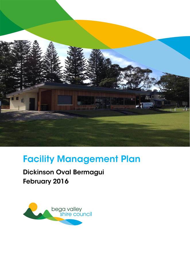

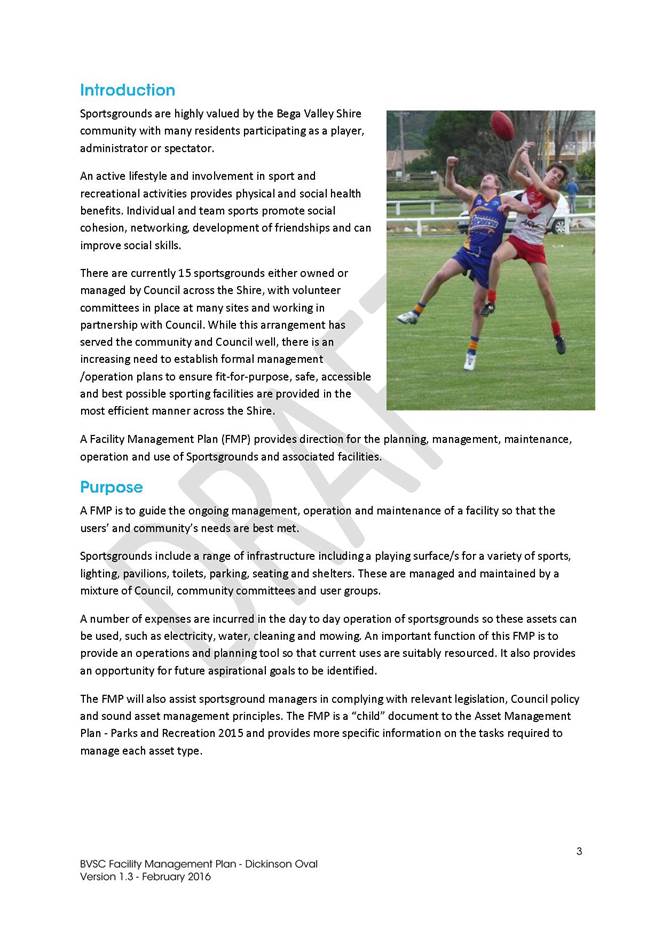
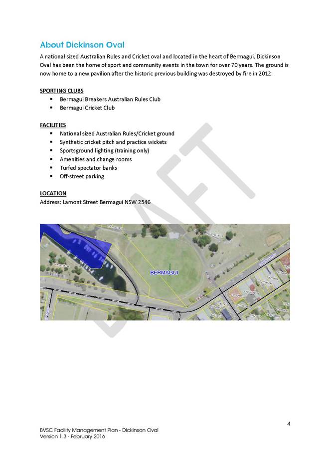
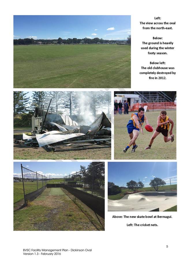
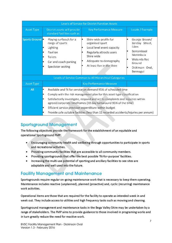
|
Council
|
20 July 2016
|
|
Item 9.4 - Attachment 1
|
Facility Management Plan - Dickinson Oval
|
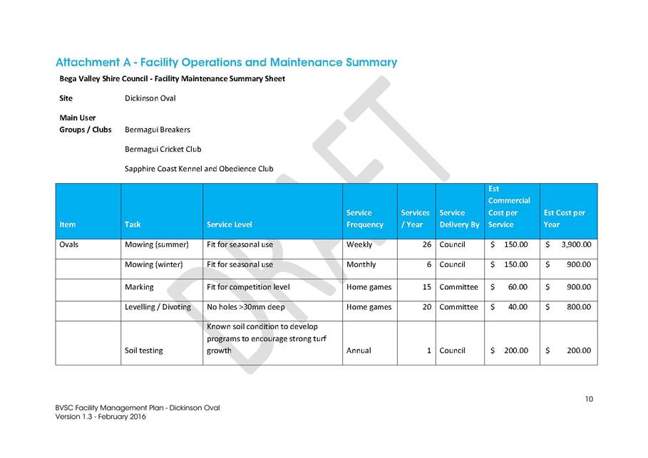

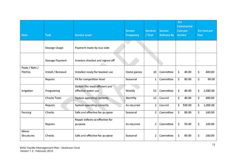
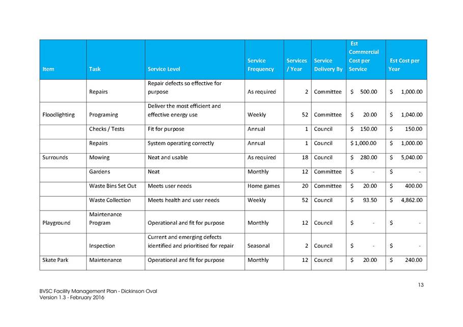
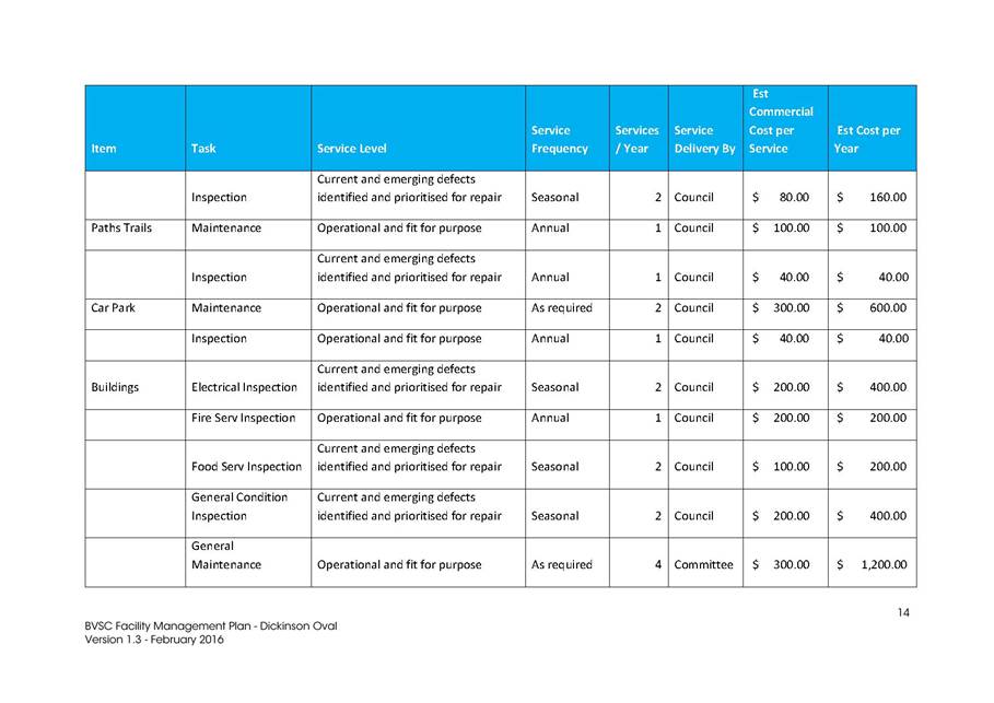
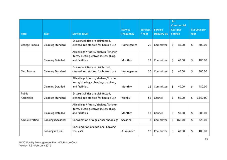
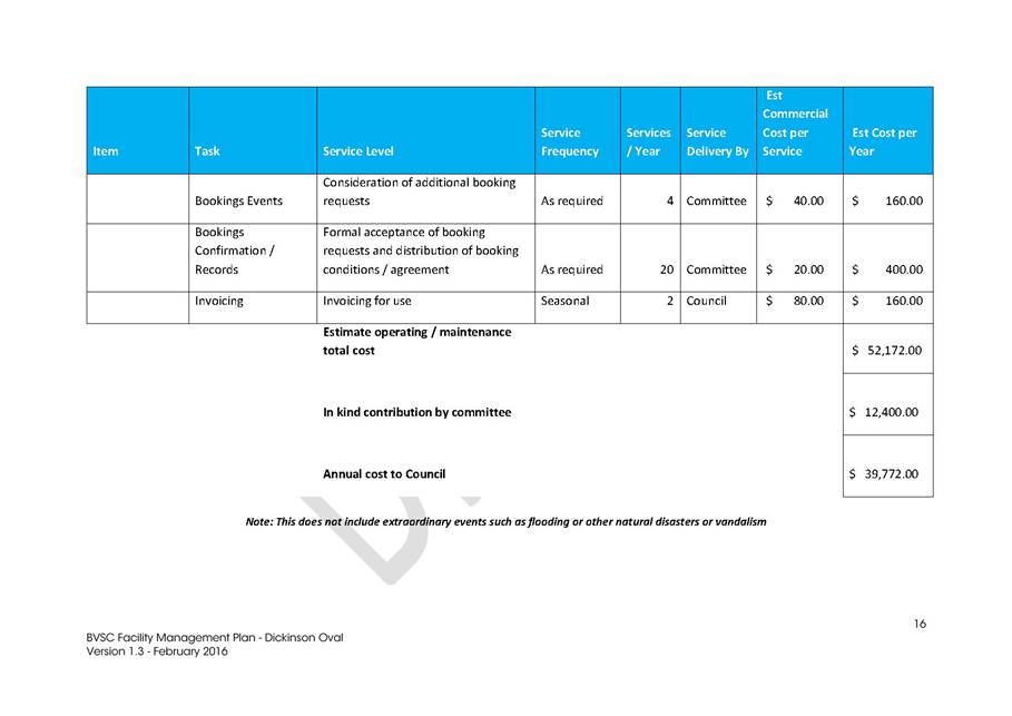
|
Council
|
20 July 2016
|
|
Item 9.4 - Attachment 1
|
Facility Management Plan - Dickinson Oval
|

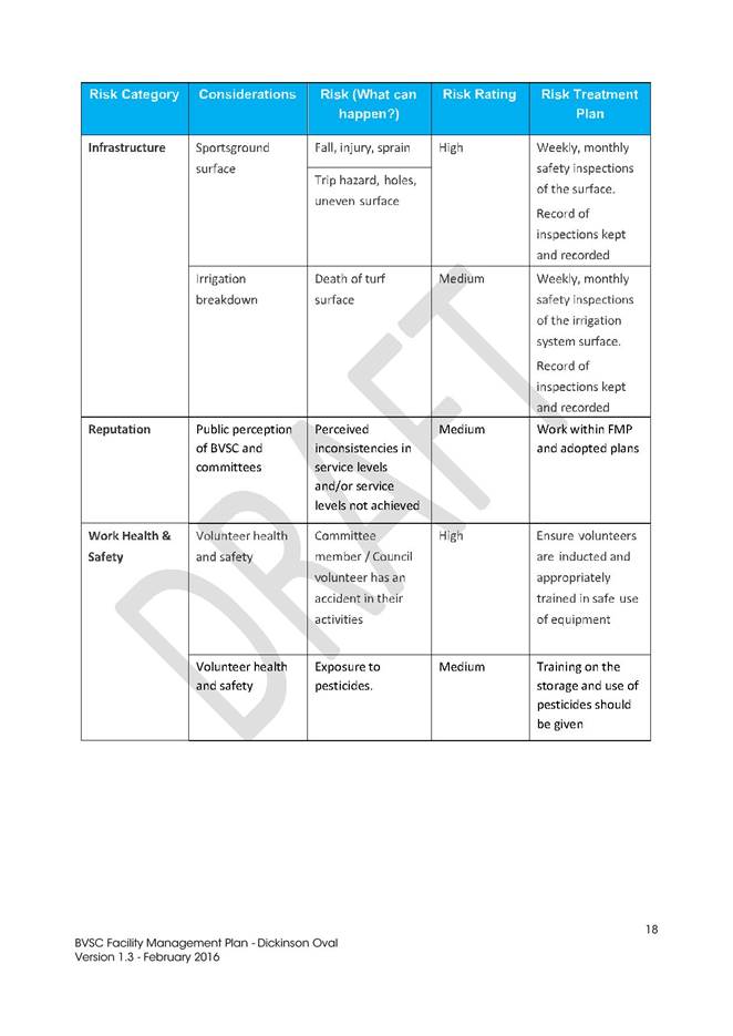

|
Council
|
20 July 2016
|
|
Item 9.4 - Attachment 2
|
Facility Management Plan - Wolumla Recreation Ground
|
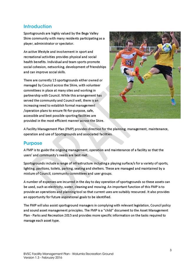
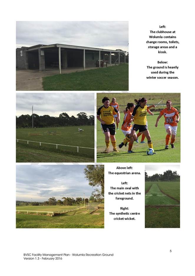

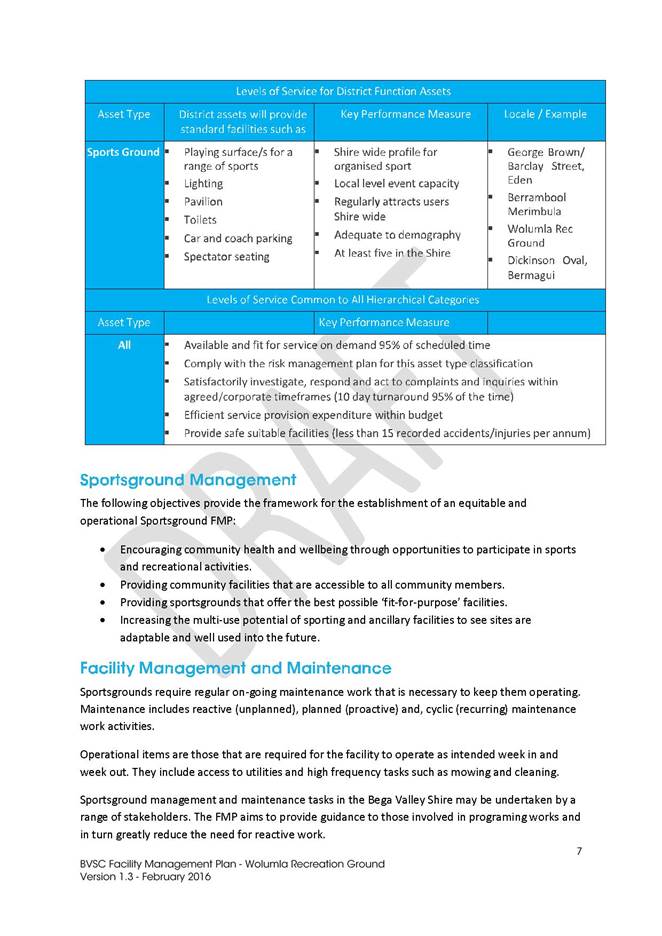
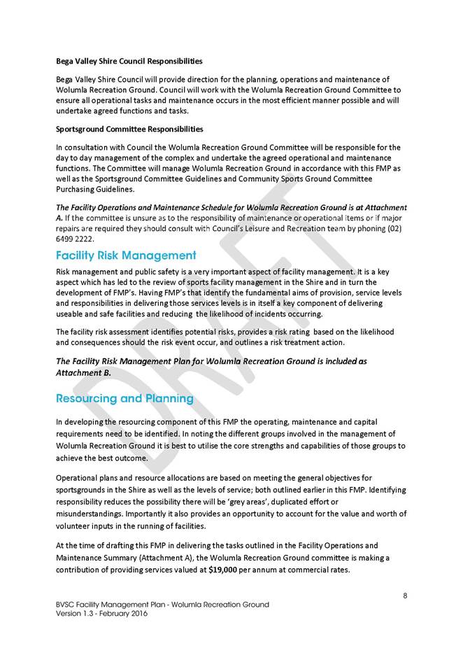
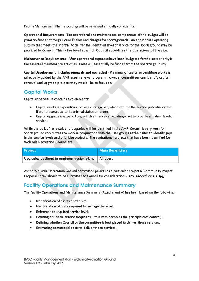
|
Council
|
20 July 2016
|
|
Item 9.4 - Attachment 2
|
Facility Management Plan - Wolumla Recreation Ground
|

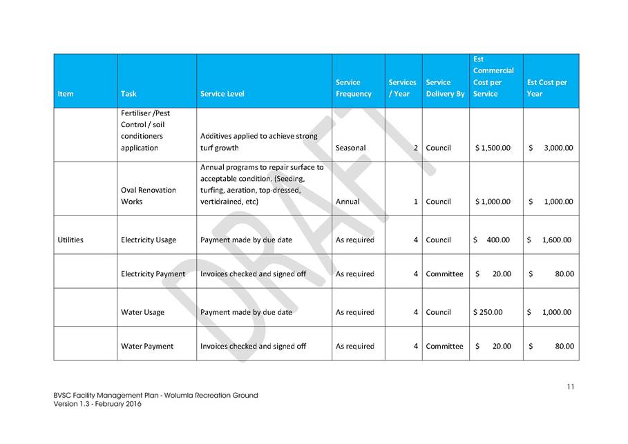
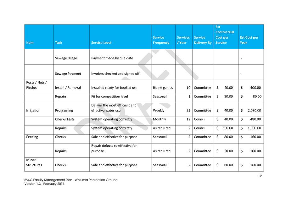
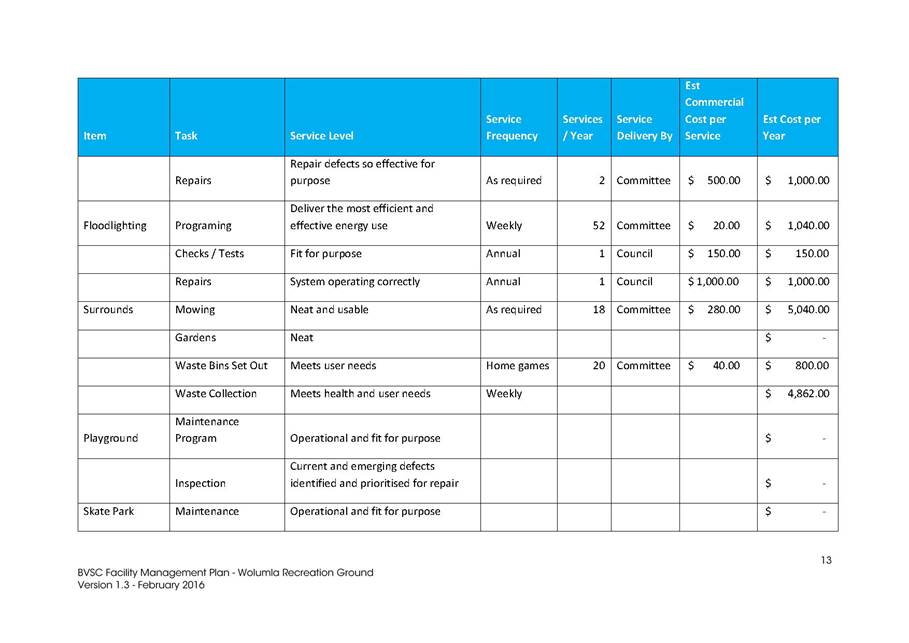
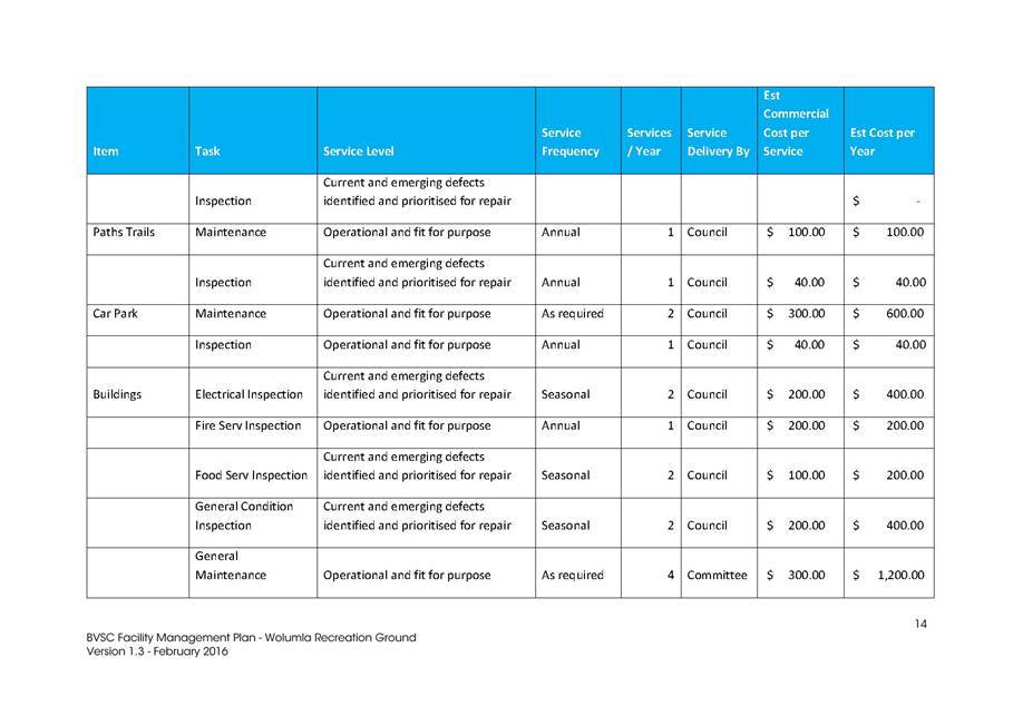
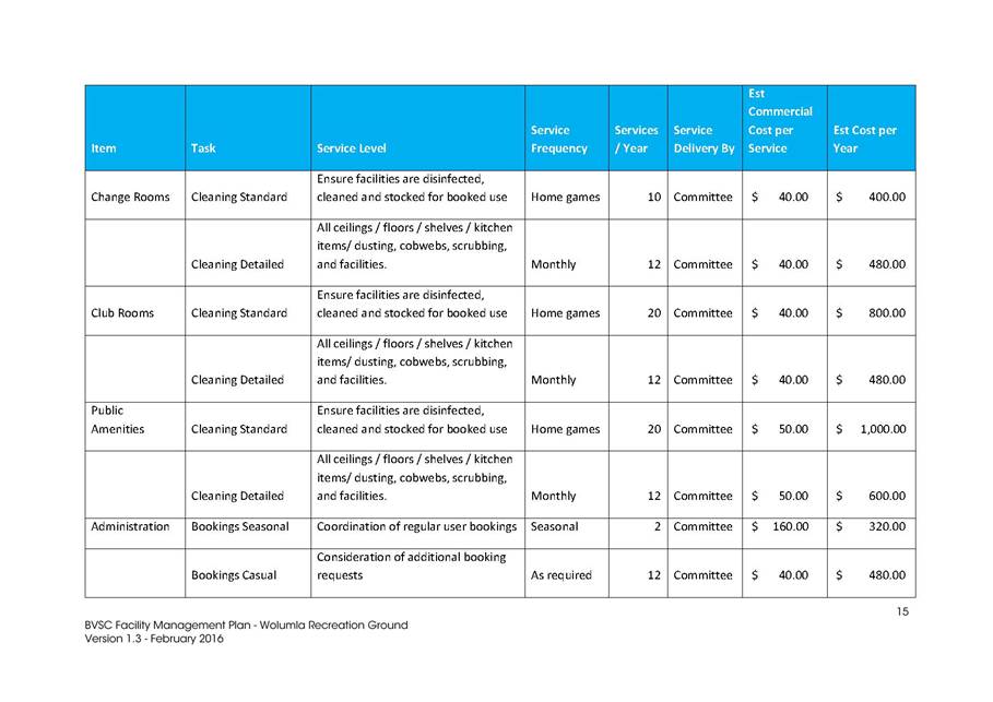
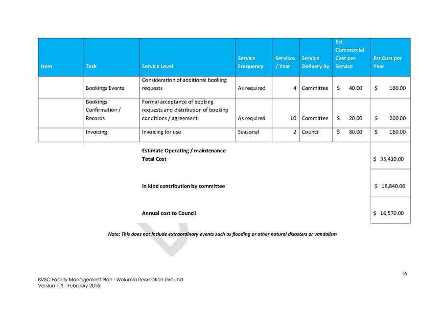
|
Council
|
20 July 2016
|
|
Item 9.4 - Attachment 2
|
Facility Management Plan - Wolumla Recreation Ground
|
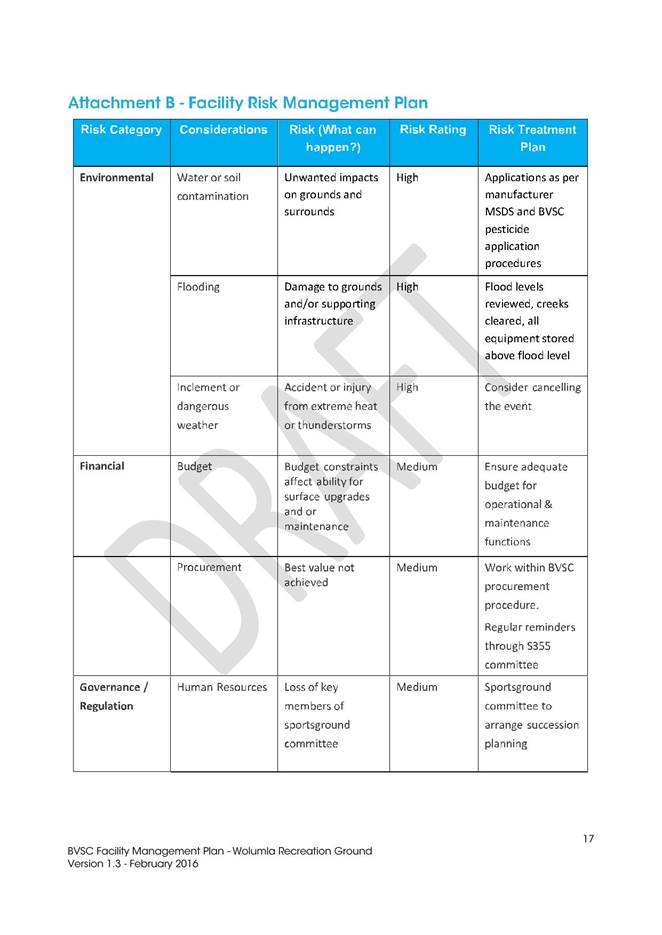


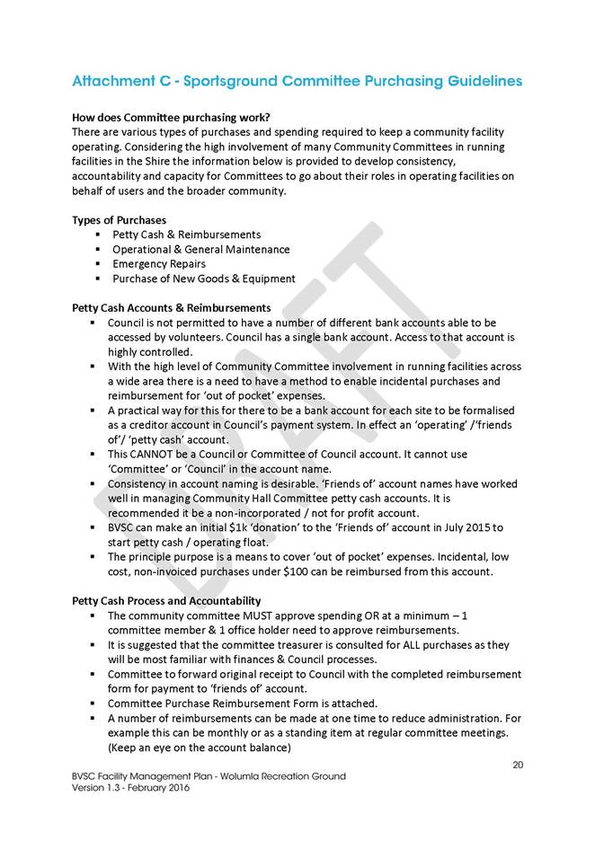
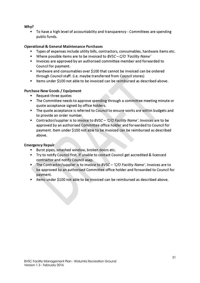
|
Council
|
20 July 2016
|
|
Item 9.4 - Attachment 3
|
Facility Management Plan - Berrambool Sports Complex
|

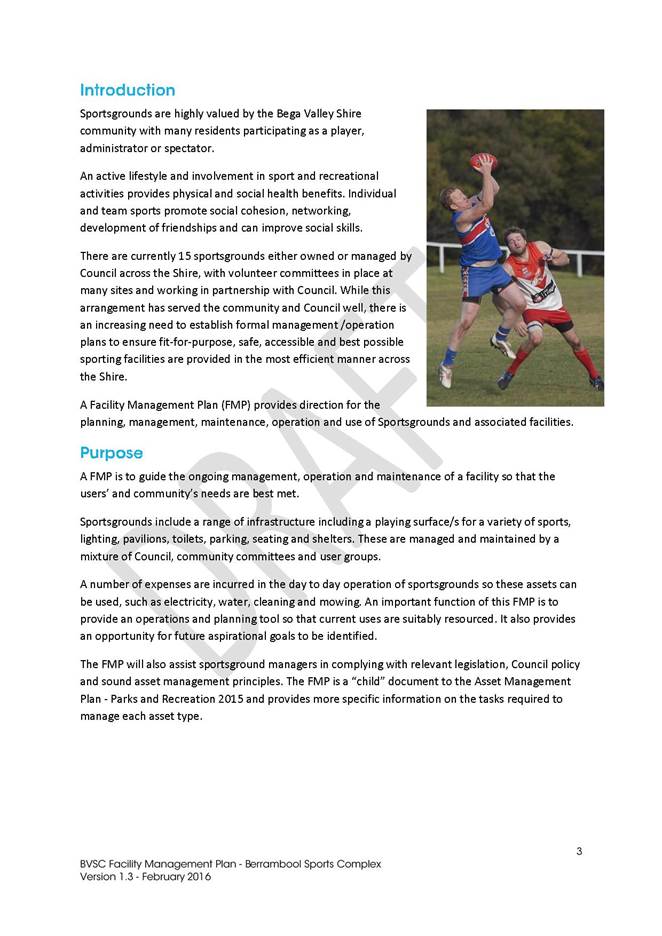
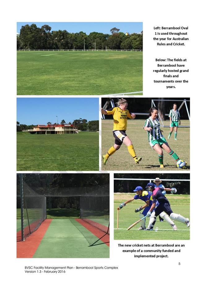
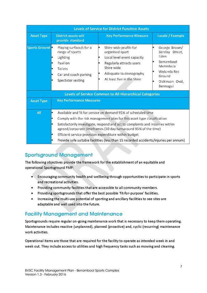
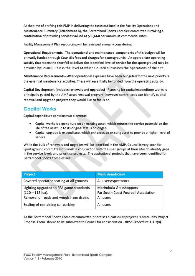
|
Council
|
20 July 2016
|
|
Item 9.4 - Attachment 3
|
Facility Management Plan - Berrambool Sports Complex
|
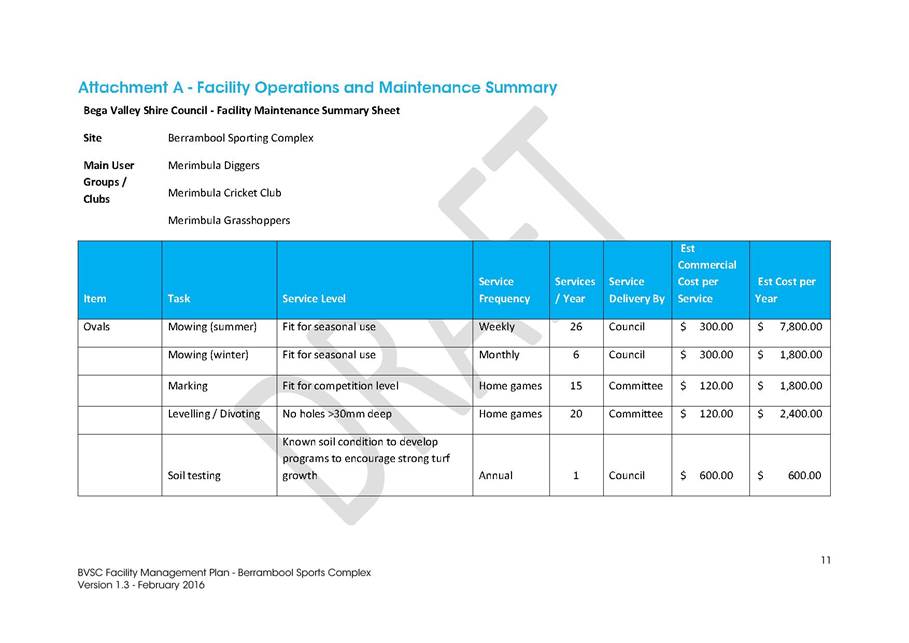
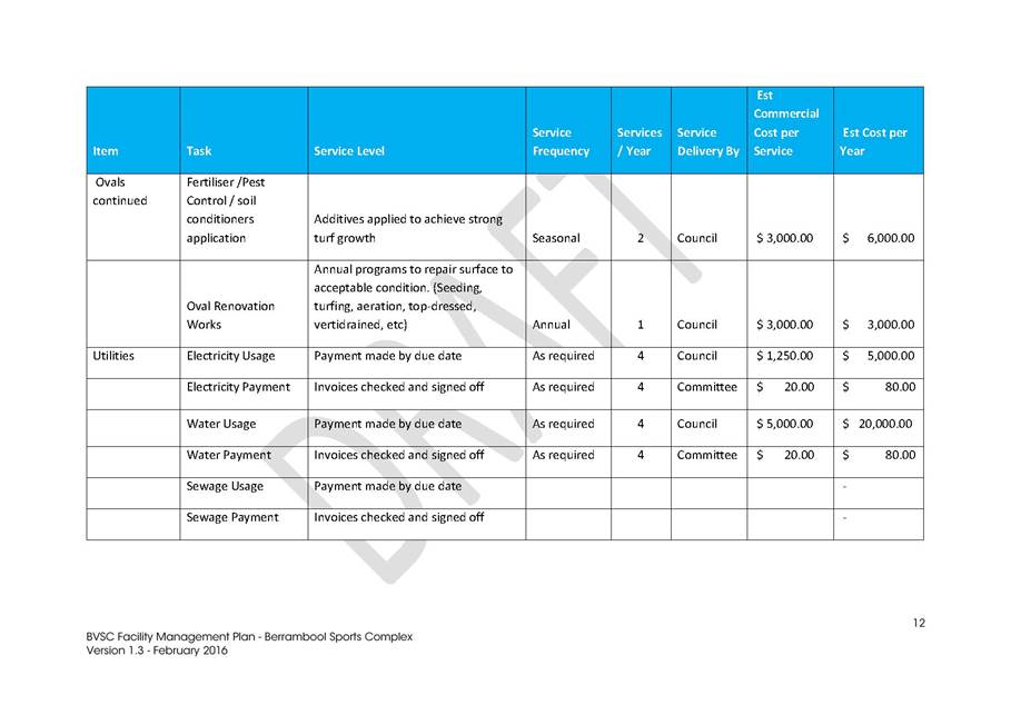
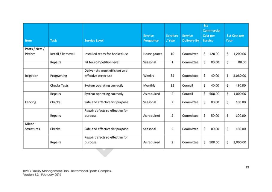
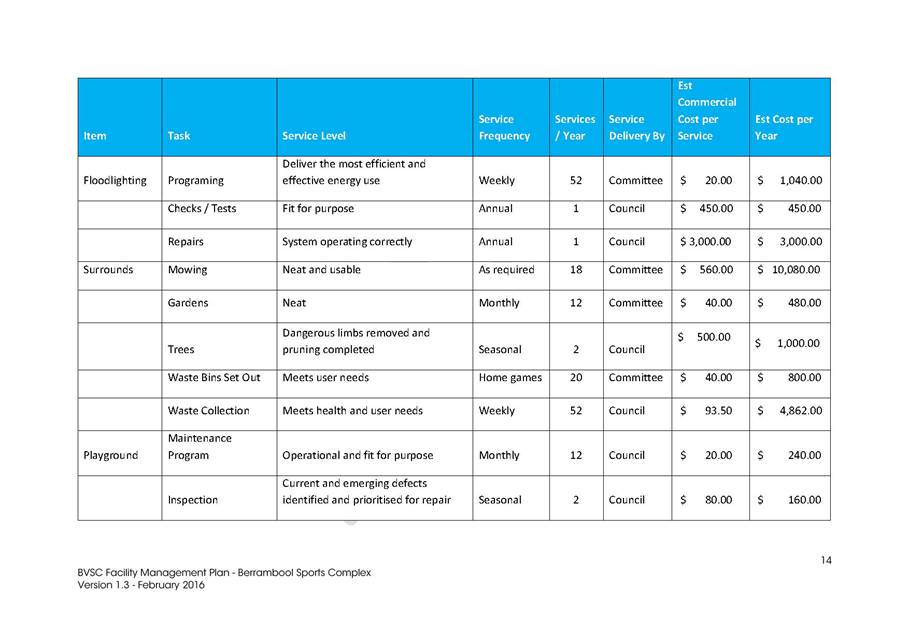
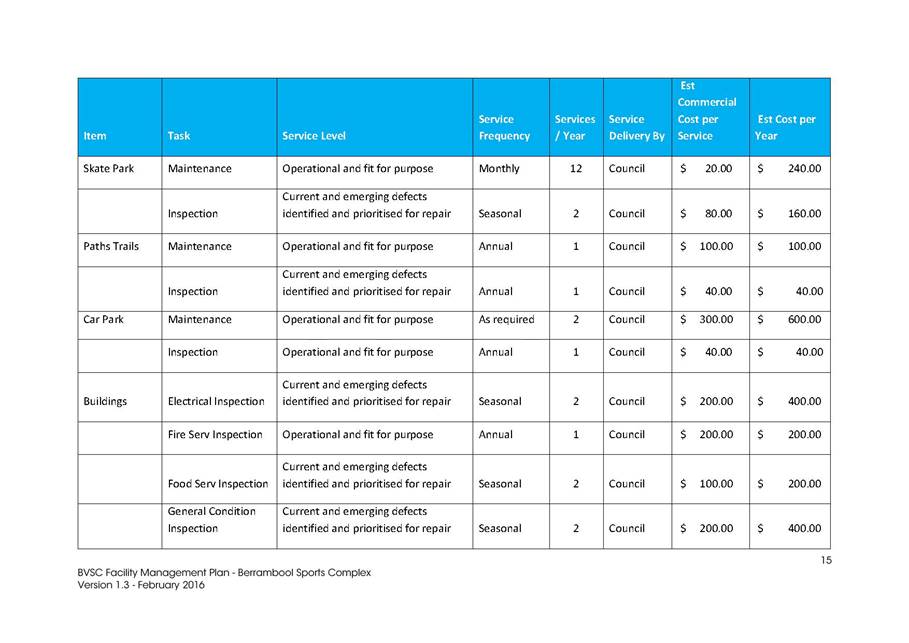
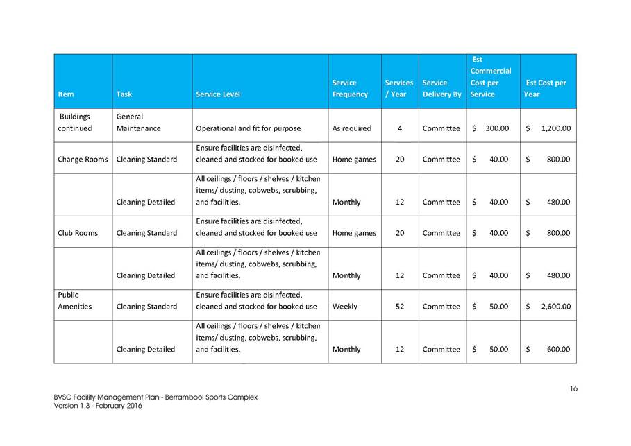
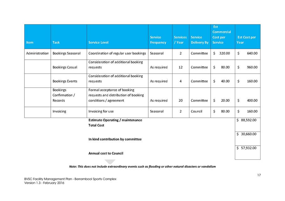
|
Council
|
20 July 2016
|
|
Item 9.4 - Attachment 3
|
Facility Management Plan - Berrambool Sports Complex
|

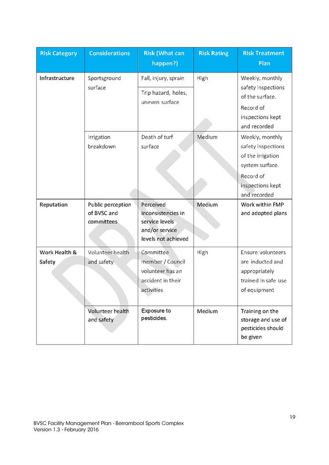
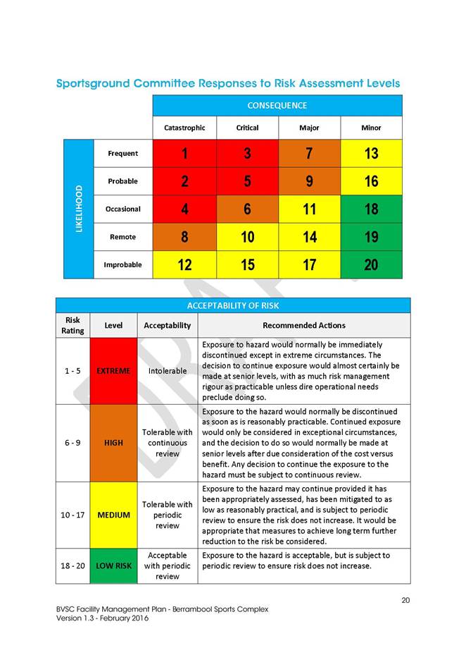

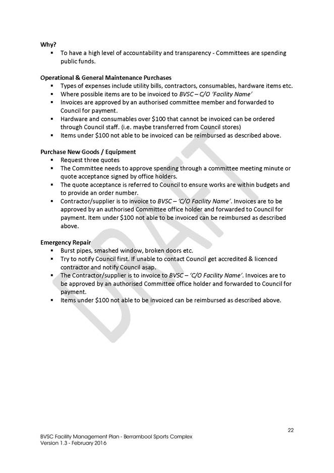
|
Council
|
20 July 2016
|
|
Item 9.4 - Attachment 4
|
Facility Management Plan - Pambula Sporting Complex
|

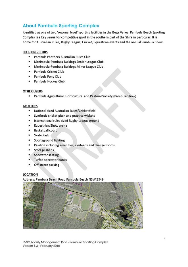
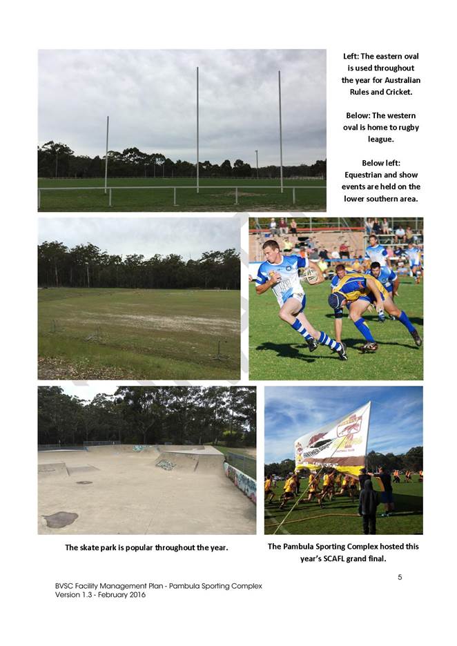
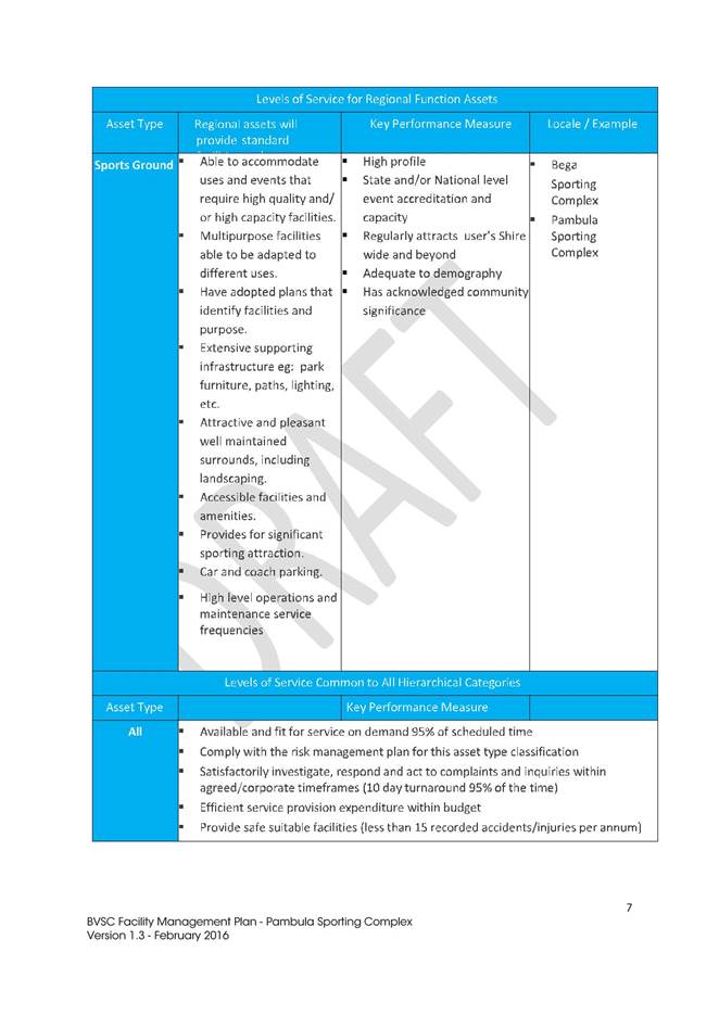
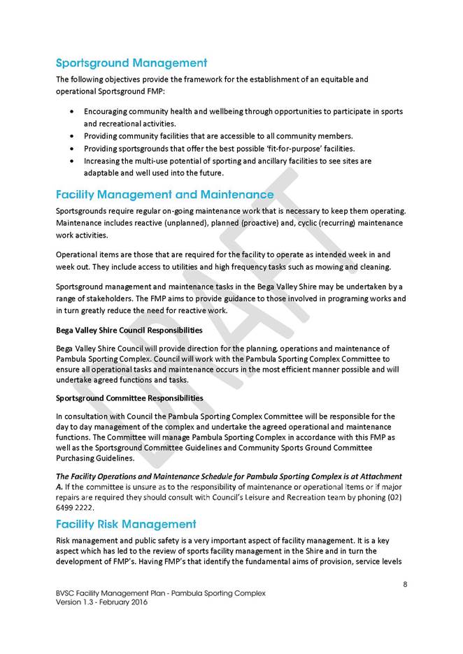
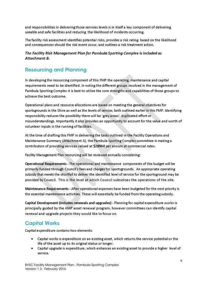
|
Council
|
20 July 2016
|
|
Item 9.4 - Attachment 4
|
Facility Management Plan - Pambula Sporting Complex
|
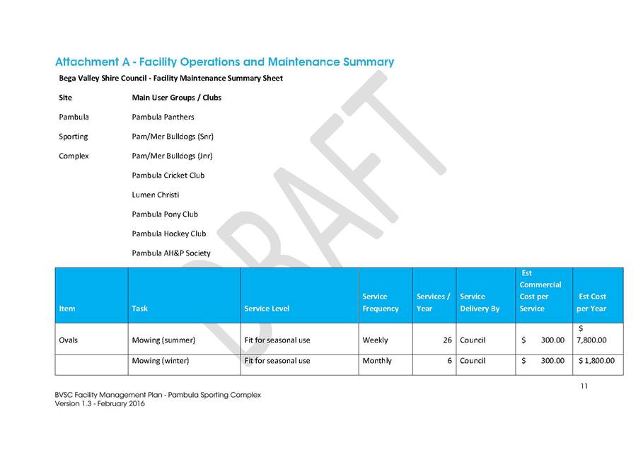
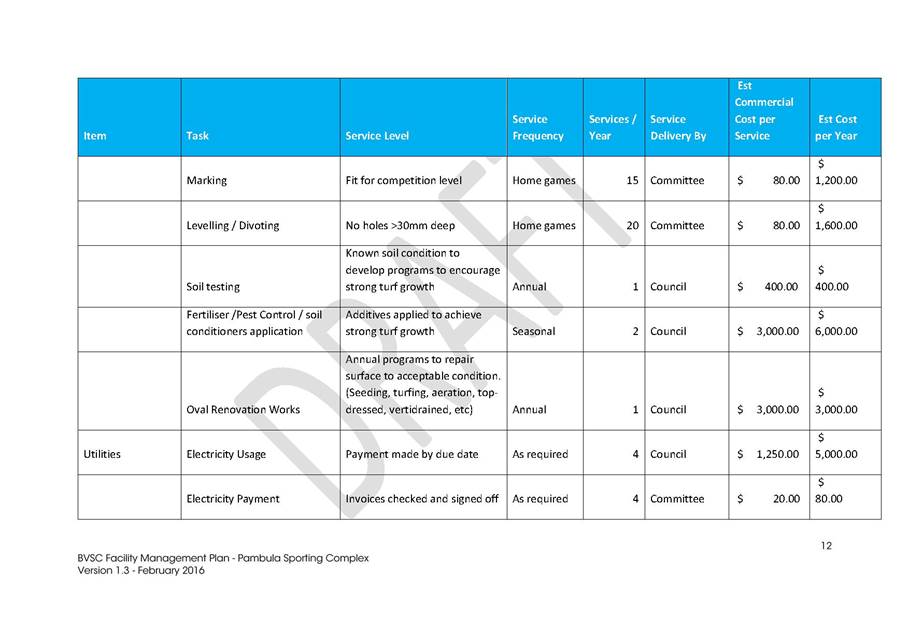
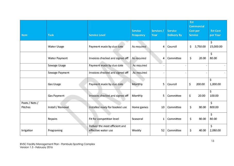
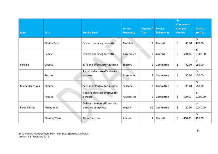
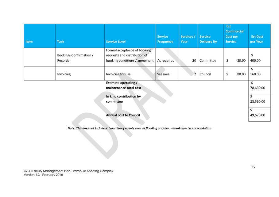
|
Council
|
20 July 2016
|
|
Item 9.4 - Attachment 4
|
Facility Management Plan - Pambula Sporting Complex
|
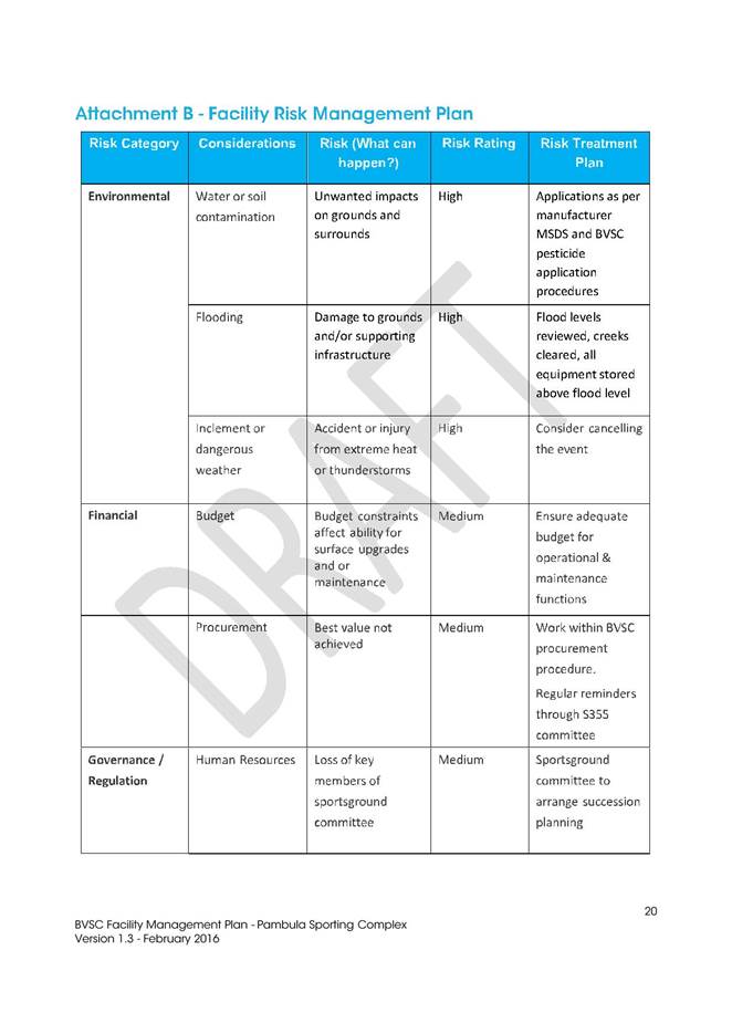
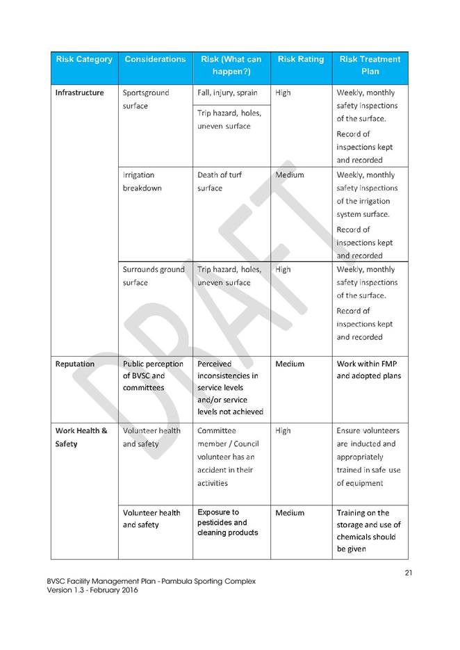
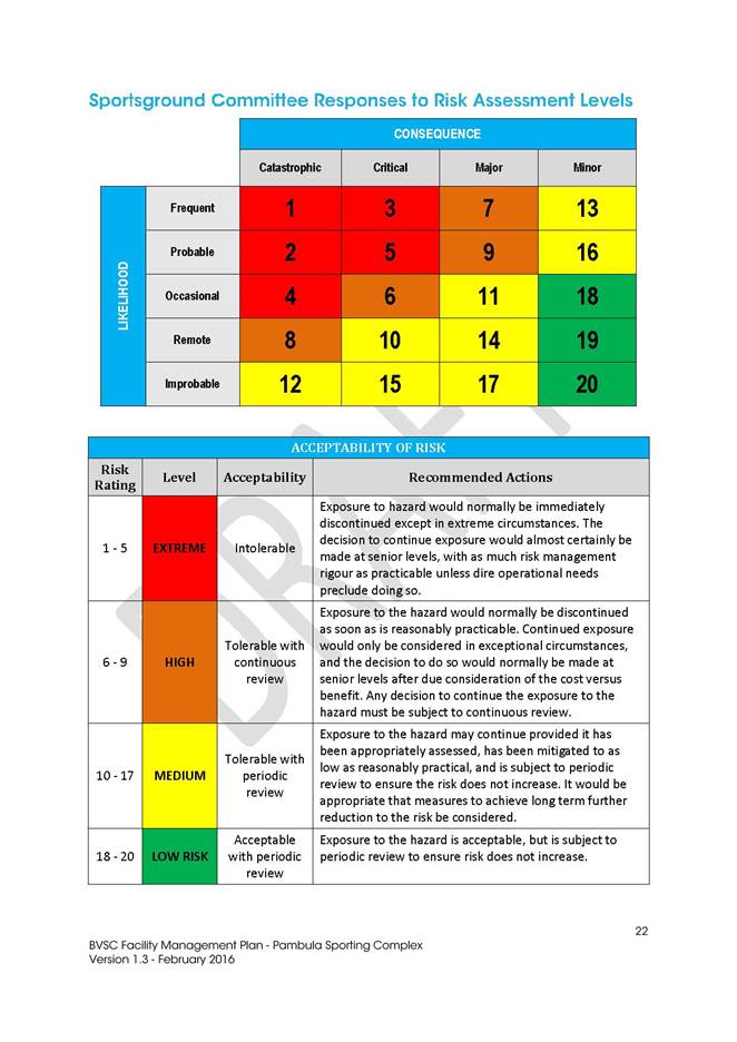
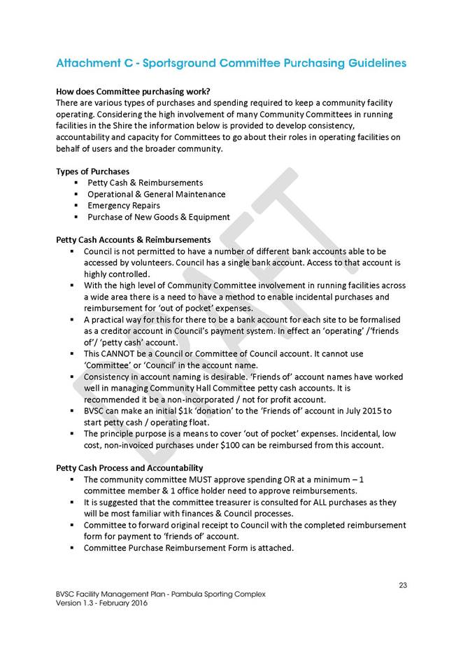
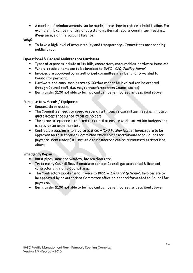
|
Council
|
20 July 2016
|
|
Item 9.4 - Attachment 5
|
Facility Management Plan - George Brown Oval
|
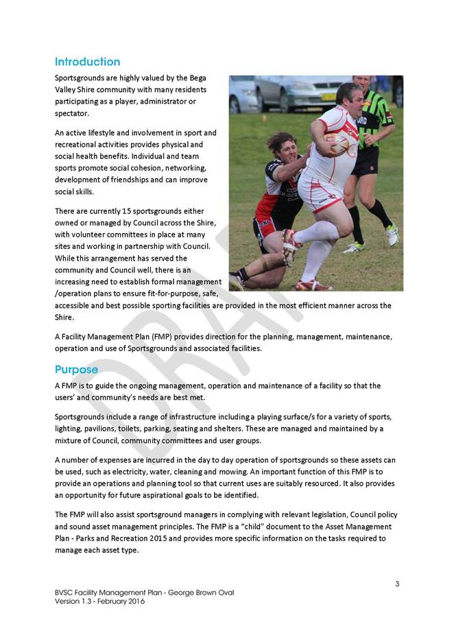
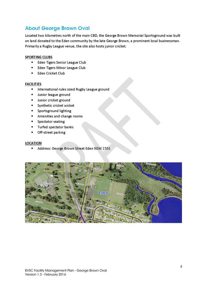
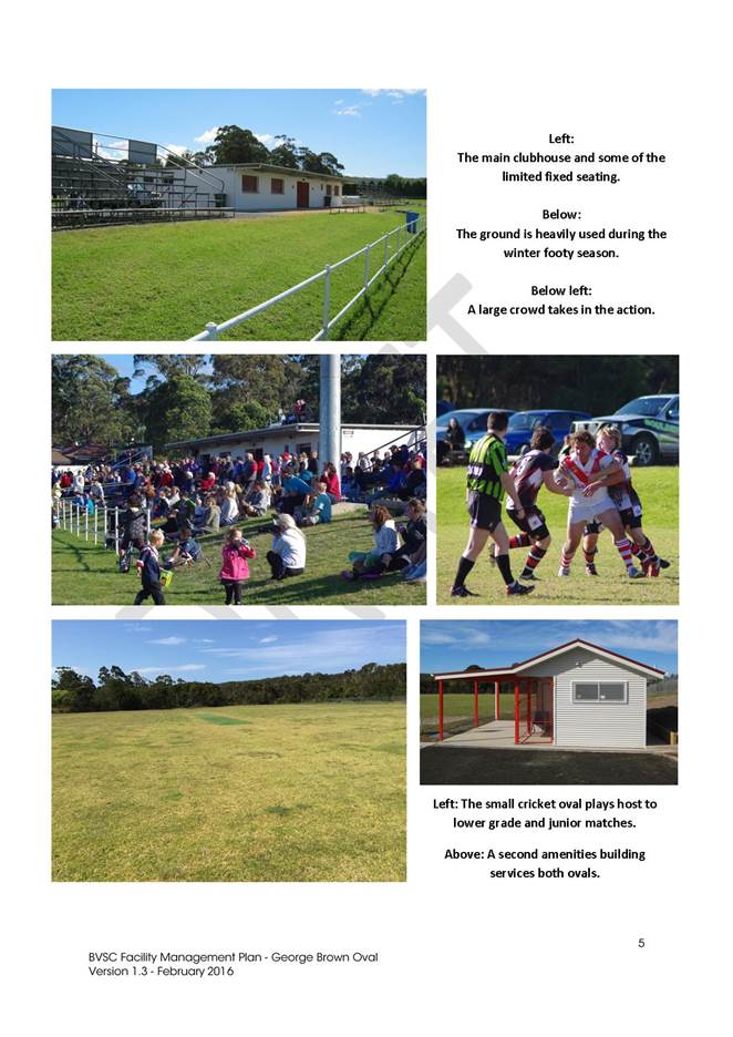


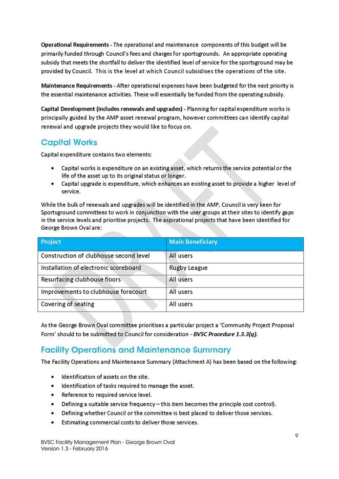
|
Council
|
20 July 2016
|
|
Item 9.4 - Attachment 5
|
Facility Management Plan - George Brown Oval
|
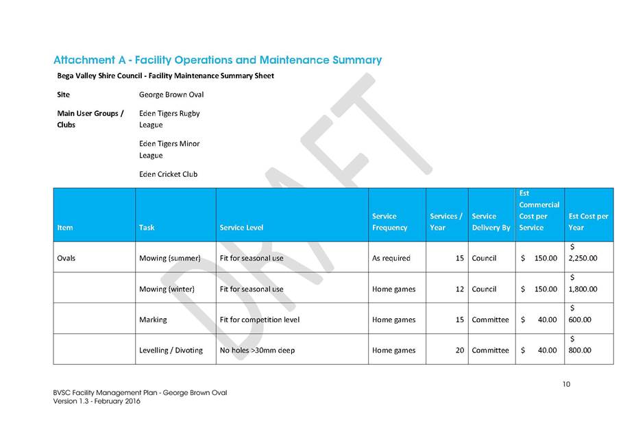
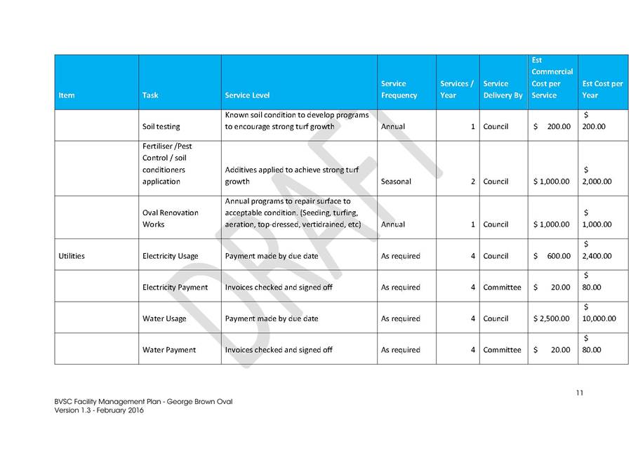
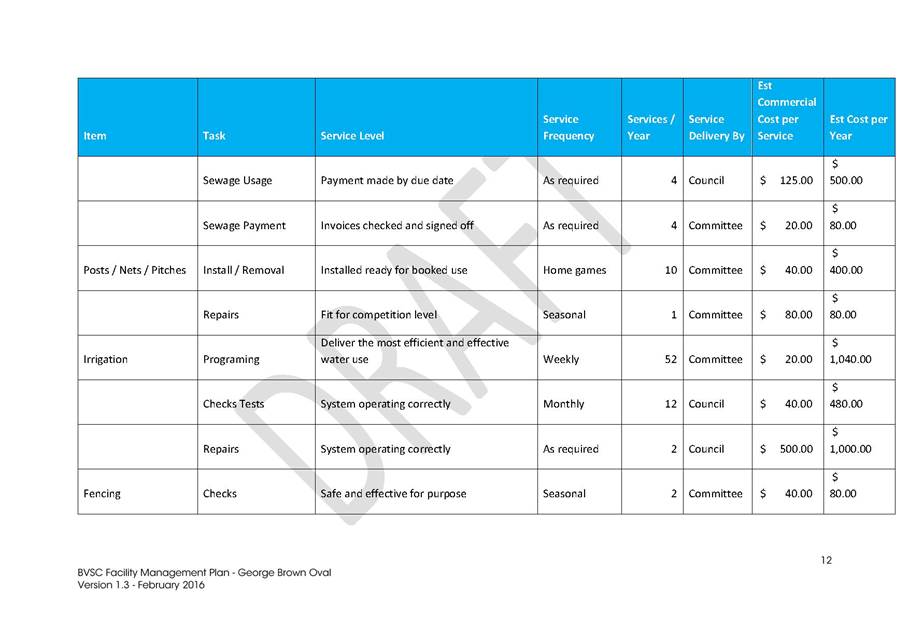
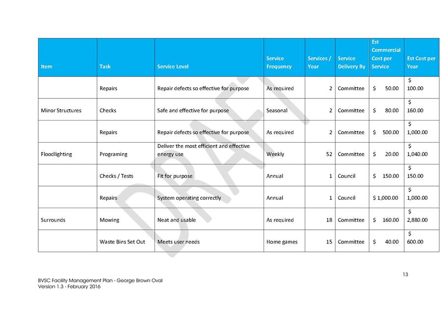
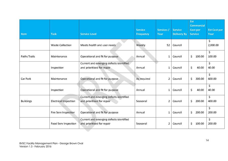
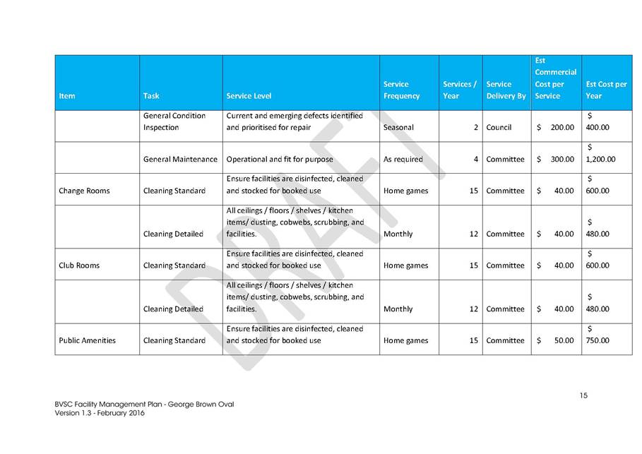


|
Council
|
20 July 2016
|
|
Item 9.4 - Attachment 5
|
Facility Management Plan - George Brown Oval
|

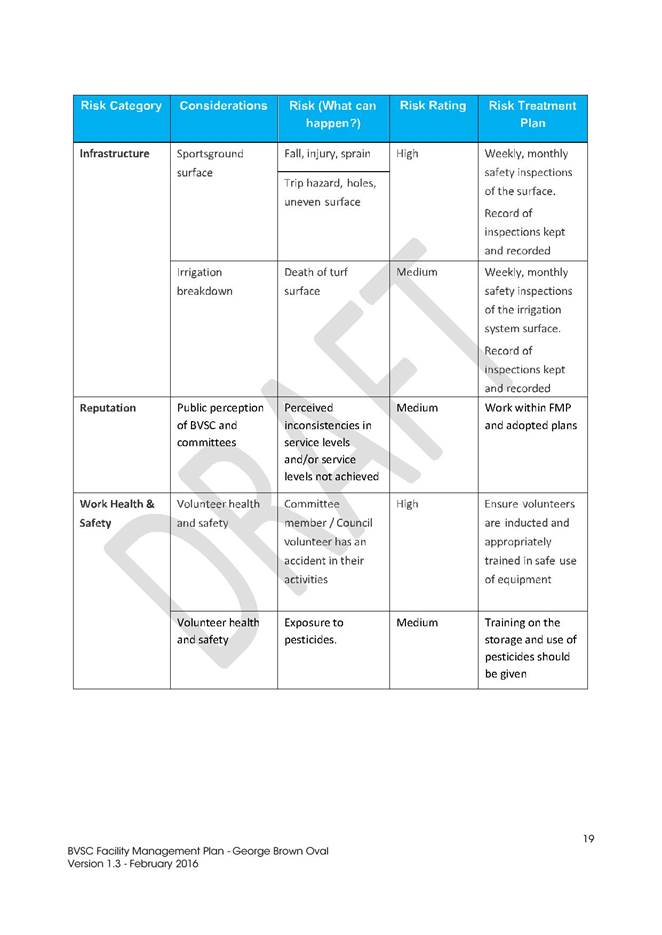
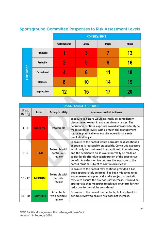

|
Council
|
20 July 2016
|
|
Item 9.4 - Attachment 6
|
Facility Management Plan - Barclay Street
|

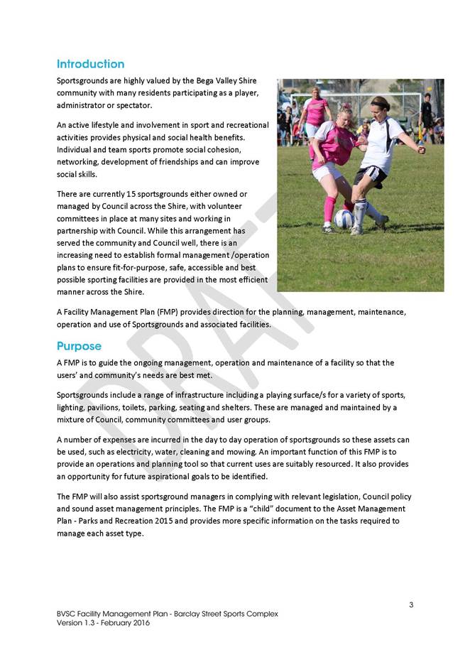
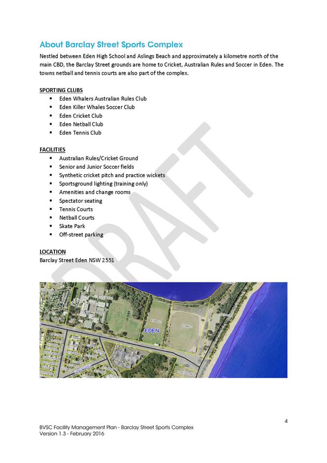
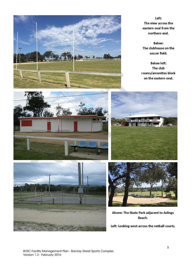
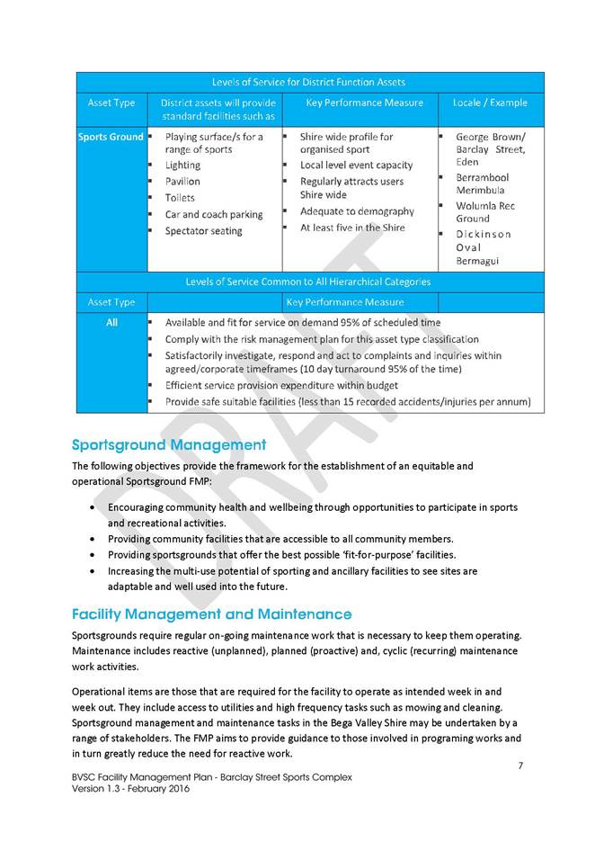
|
Council
|
20 July 2016
|
|
Item 9.4 - Attachment 6
|
Facility Management Plan - Barclay Street
|
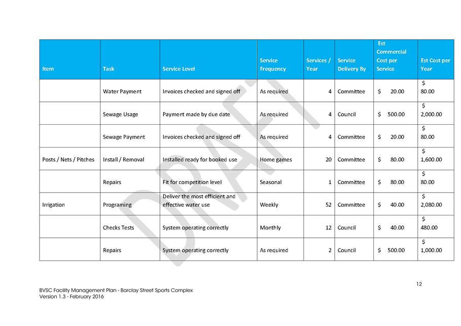
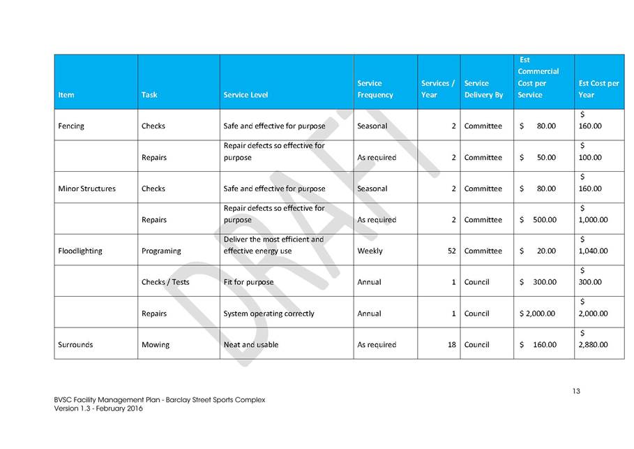
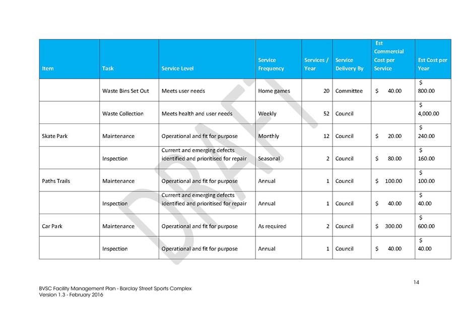

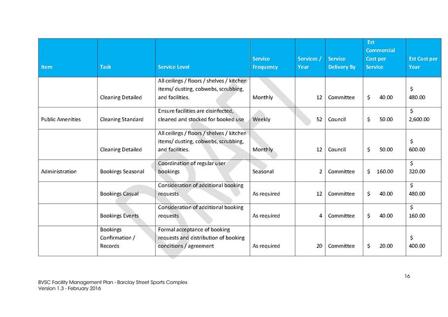
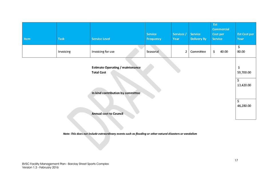
|
Council
|
20 July 2016
|
|
Item 9.4 - Attachment 6
|
Facility Management Plan - Barclay Street
|


|
Council 20 July 2016
|
Item 9.5
|
9.5. Quarterly Community Project Proposals Summary
This report provides a summary
of community project proposals received between 1 April 2016 and 30 June 2016 for
Council's information and consideration.
Director Community, Relations and Leisure
Background
The community has an important role in helping Bega Valley
Shire Council (BVSC) identify and deliver new and/or improvements to community
facilities. New proposals, regardless of the project size, that require Council
involvement need to be considered in the context of all project elements
including: funding; personnel; procurement; risk management; workplace health
and safety; environmental considerations; approvals; compliance; and ongoing
maintenance. It is also important to consider how the proposed works can link
and add value to other Council projects, particularly in terms of the
maintenance and replacement of existing assets.
Council’s Community Project Proposal Procedure applies
to the full spectrum of projects from small scale to larger scale and through
to more complex projects. One of the aims of the procedure is to make sure all
relevant project issues are considered and addressed.
It is important to be able to give proposals the
consideration they need and deserve, and to work out where they fit with other
planned and programed works. The level of resourcing and contribution sought
from Council is an important consideration. The level of information included in
the proposal should be sufficient to enable the merits and issues of proposals
to be understood by officers, before going to Council. This initial assessment
by officers seeks to minimise wasted effort (or expense) on proposals that may
not obtain approval due to funding, planning or other reasons.
The complete Community Project Proposal Procedure and the
Proposal Form is available on Council's website.
This report contains proposals received between 1 April 2016 and 30 June 2016. Future proposals
will continue to be presented on a quarterly basis to Council for consideration
and resolution.
Attached is a summary of the Project Proposals received
including comments and recommendations. Hard copies
of each of the full proposals received and the project assessment checklist
have been distributed to Councillors for their reference and review. It should
also be clear that in-principle support does not commit Council to funding the
project, only support, which enables applicants to progress with project
development.
Issues
Legal
There can be legislative requirements
that come into effect if the implications of works are not understood and
accounted for in the project development stage. These include: environment and
heritage; access and building code compliance; planning and development
approvals; and in some instances land ownership.
Strategic
Council has a number of
strategic and operational plans that outline the current and future priorities
of infrastructure, civil assets and facilities. For example Asset Management
Plans (AMP) identifies current assets, their condition and when they are
programed to be replaced. The Long Term Financial Strategy (LTFP) outlines how
Council will pay for the replacement or upgrade of those assets.
Policy
Council’s Procedure 4.01.3
Community Project Proposals has been developed to manage project proposals by
committees and community groups for the development and delivery of community
infrastructure, civil assets and facilities.
The objective is to provide a
clear and consistent approach for Council officers, committees and community
groups across the broad range of project types, scale, funding sources and
delivery methods.
Submission of a Community
Project Proposal does not guarantee approval. On occasions projects deemed as
suitable may, for a number of reasons such as inadequate resources, be unable
to proceed in the first instance. In these circumstances it may be appropriate
for Council to formalise in-principle support for the project as this may
provide opportunities for the applicant to source funding through other
agencies.
Operational Plan
Relevant key directions
identified in the Council’s Operational Plan 2015/2016 are:
S4 Proactive support and
planning: There is proactive planning with the community for the protection of
our built and natural environment.
A2 Facilities and services:
Our infrastructure, facilities and services are strategically planned, located,
designed and maintained to meet our local and visiting community needs.
Asset
Council has an adopted capital works
programs included within the asset management structure. Asset management
capital works programs are based on asset renewal (e.g. replacing existing
assets to meet a similar service or provision level) as determined in
Council’s AMP. The large majority of projects proposed by the community
relate to new works or significant upgrades of existing assets. As such
provision has not been made for including proposed projects in capital works
programs already part of the AMP. Where projects are linked to works
identified in AMP’s this is clearly noted.
Social / Cultural
The community has an important
role in helping Council identify and deliver new and/or improvement projects.
Council recognises and values the important role and contribution of
committees, community groups and volunteers in the management, operation and
maintenance of Council infrastructure, civil assets and facilities.
Consultation
In developing the Community
Project Proposal Procedure, consultation was undertaken with Council's Access
Committee, the S355 Sportsground Committee and also through a workshop
involving representatives of service organisations from across the Shire.
The Project Proposal form
includes a section on stakeholder engagement in which the applicant can
identify the consultation they have undertaken and feedback they have received
in the development of their proposal.
The summary included with the
previous Community Project Proposal report to Council on 6 April 2016 included
four proposals from the ESSCI group in Eden. Council officers have met with
ESSCI to prioritise their proposals. The Lake Curalo Common project was
acknowledged as their priority project and has been included with the summary
attached.
Financial and Resources
Committees, community groups and
volunteers often seek funding and grant opportunities to support their project
proposal. It is important these people talk with officers prior to applying for
funding to do work on Council assets. This ensures the project scope is clear
and complete, the amount being sought is sufficient to complete the works and
there is a level of coordination to prevent already approved projects competing
with new projects for the same grants. This process also ensures that the
grants available from these community groups and the community endeavour is
supported and leveraged to ensure the best and most sustainable outcome.
The table below shows a summary
of Community Project Proposal applications received 1 April 2016 and 30 June
2016. Some applications do not require funding from Council, only permission and
as such have been approved and completed.
|
Total Proposals Received
|
7
|
|
Proposals approved – (Funded by applicant or
required works)
|
2
|
|
Total value of all proposals
|
$86,320
|
|
Total Council contributions requested
|
$64,020
|
|
Proposals un-costed by applicant
|
1
|
|
Minor and Medium Projects
|
7
|
|
Council contributions requested
|
$64,020
|
|
Council contributions
- Approved or recommended (Required works)
|
$1,320
|
|
Council contributions
requested – Outstanding works
|
$62,700
|
|
Applicant contributions
|
$22,300
|
|
Total value of minor and medium projects
|
$86,320
|
|
Major Projects
|
0
|
Conclusion
The Community Project Proposal process
seeks to provide a consistent framework for Council to receive and consider the
wide range of suggestions for infrastructure projects put forward by the community.
Often these projects relate to new works or major upgrades and as such have not
been identified in the development of capital works programs included in AMPs.
The challenge is to give
proposals the consideration they need and deserve and to work out where they
fit with other planned and programed works. The level of resourcing and
contribution sought from Council is an important consideration.
Attachments
1. Community
Project Proposals Summary - June 2016
Recommendation
1. That
Council note those Community Project Proposals already approved.
The
On Track Committee for the removal of asbestos (project Bega1) and Merimbula
Chamber of Commerce to install fairy lights (project Mer1) have been
approved.
2. That
Council adopt the following recommendations for the Community Project
Proposals:
a. Council
provide in-principle support for the construction
of an amenities building at Evans Park, Kalaru and subject to required
project information being provided, officers work with the group in
identifying external funding opportunities. (Project Bega2)
b. Council
provide in-principle support to the
Pambula-Merimbula Lions Club for the refurbishment of the Berrambool footbridge
and subject to required project information being provided, officers
work with the group in identifying external funding opportunities. (Project
Mer2)
c. Council
provide in-principle support to the Rotary Club
of Pambula (Eden Section) to further develop
the extension of Rotary Park Walk and subject to required project
information being provided, officers work with the group to develop the
project. (Project Eden1)
d. Council
provide in-principle support to the Wonboyn
Ratepayers Association to further develop the Wonboyn
Road Beautification proposal and subject to required project information
being provided, officers work with the group in identifying external funding
opportunities. (Project Eden2)
e. Council
provide in-principle support to ESSCI to progress with the Curalo Common
Project and subject to required project information being provided, officers
work with the group to develop the project. (Project Eden3)
|
|
Council
|
20 July 2016
|
|
Item 9.5 - Attachment 1
|
Community Project Proposals Summary - June 2016
|
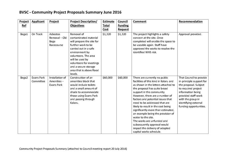
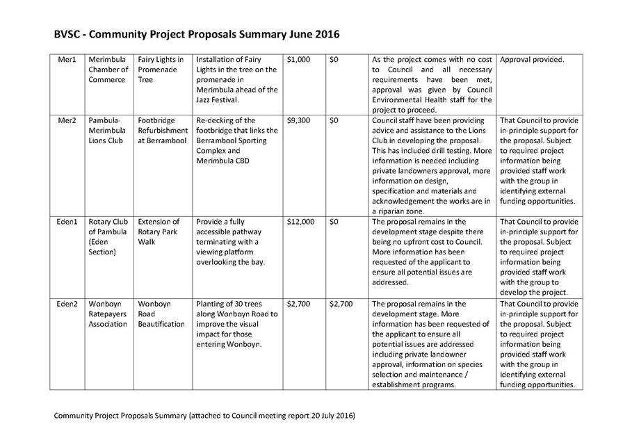
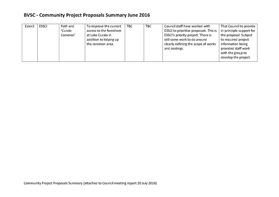
Staff Reports – Economic Develoment and Business Growth (Enterprising)
20 July 2016
In accordance with Council’s Code of Meeting
Practice (2011), this section of the agenda will be chaired by Cr McBain.
10.1 RFT
02/16 Gateway Signage to the Bega Valley............................................... 324
10.2 Expression
of Interest EOI 53/16 142-144 Imlay Street, Eden.......................... 326
|
Council 20 July 2016
|
Item 10.1
|
10.1. RFT 02/16 Gateway Signage to the Bega Valley
This
report details the outcomes of an Evaluation of Tender RFT 02/16 for Gateway
Signage to the Bega Valley.
Director Strategy and Business Services
Background
Bega Valley Shire Council’s Economic Development
Strategy states an intention to “deliver a visitor signage program,
including Shire entrances”. The Gateway Signage project is the
first stage in a comprehensive program that will ultimately see unique and high
quality signage in place across the Shire at the town, village and locality
levels.
Gateway Signage referred to in this process intends for the
installation of significant and individualised structures welcoming visitors
and travellers to the Shire at the major entry points: north of Cobargo; south
of Eden; and at Brown Mountain heading towards Bemboka.
Council approved design concepts informed by information and
feedback received as part of the Signage and Heritage Review conducted by
Sapphire Coast Tourism on behalf of Council.
An indication of what Council approved and what respondents
to this process were required to consider and scope their submissions against,
is shown in the attached diagrams.
The program is funded through the Council’s tourism
infrastructure special variation and associated reserve.
The tenders were evaluated in accordance with the evaluation
criteria, weighting and scoring criteria as follows:
Value for Money (40%) made up as follows:
· The overall
project cost
· The makeup of the
cost structure and
· Commercial terms
and conditions.
Project experience (50%) made up as follows:
· Demonstrated
ability to complete the work
· Experience in
completing similar projects
· Quality, Safety
and Environmental systems and experience and
· Financial ability
to undertake project of this size.
Project functionality (5%) made up as follows:
· Proposed
construction arrangements and completion program
Local community benefit (5%) made up as follows:
· Recognition of
local outcomes, demonstrating support for local business and community
enterprise.
The value of the tenders received is not within the current
budget allocation for the works. The evaluation of the tenders received is
attached in a Confidential Memorandum to Councillors.
Issues
Legal
The tendering process complies with the Local Government
(General) Regulation 2005.
Operational
Plan
The proposed works are in accordance with design concepts
presented to and adopted by Council in late 2015.
Environmental
/ Sustainability
Once the three (3) respective sites are agreed, a Review of
Environmental Factors (REF) will be completed for the project with measures
identified to protect the environmental values of the area during construction.
Social
/ Cultural
The Gateway Signs once in place will be significant
structures that will welcome tourists and travellers and make a strong
statement on behalf of the entire Bega Valley Shire.
Consultation
Consultation has occurred as part of the project.
Financial
and Resources
The Tender responses received are not within the budget
allocated for the Gateway Signage project.
Conclusion
This report provides information about the tender evaluation
process and advice by way of Confidential Memorandum on assessment of the
received tenders and provides recommendations for Council to consider.
Attachments
1. Confidential
Memorandum to Councillors RFT 02/16 (Councillor Only) (Confidential)
|
Recommendation
1. That
Council accept the recommendations as outlined in the Confidential
Attachment.
2. That
authority is delegated to the General Manager to execute all necessary
documentation.
3. That
tenderers be advised of Council’s decision.
|
|
Council 20 July 2016
|
Item 10.2
|
10.2. Expression of
Interest EOI 53/16 142-144 Imlay Street, Eden
This
report details the results of an Expression of Interest process calling for
proposals from community and commercial interests seeking an involvement in the
Hotel Australasia, Imlay Street Eden.
Director Strategy and Business Services
Background
Council purchased the Hotel Australasia on 7 March 2016
following a resolution to do so at the 24 February 2016 Council meeting.
One of the motivating factors for Council to purchase the building was the
opportunity to preserve and restore a historic and prominent building in the
centre of Eden. The focus of particular attention is the remarkable
façade and the surviving detail that is presently concealed. An
incorporated community group has been formed and continues with the objective
of seeing the Hotel Australasia building and site retained for future
generations.
At the 27 April 2016 Council meeting it was resolved that an
Expression of Interest (EOI) process be run in order to seek and receive
submissions from both community based and commercial entities, seeking to play
a part in the restoration of the former Hotel Australasia site located at
142-144 Imlay Street, Eden.
The community level involvement of support to contribute to
the restoration through the community group Eden’s Australasia is
assured.
The EOI process was envisaged as an opportunity for both
formal offers of trade related budget relieving in-kind support being made
towards the restoration and/or development type proposals.
The EOI documentation identified evaluation criteria,
weighting and scoring as follows:
1. 75%
Project experience, made up as follows:
· Demonstrated
ability to meet the work
· Experience in
completing similar proposed tasks
· QA experience
· Financial ability
to undertake project of this size
2. Local
Community Benefit, made up as follows:
· Recognition of
local outcomes, demonstrating support for local business and community
enterprise
Issues
Legal
The EOI process complies with the Local Government (General)
Regulation 2005.
Asset
142-144 Imlay Street Eden is an asset of the Bega Valley
Shire Council.
Social
/ Cultural
The importance of the restoration of the façade and
preservation of the building to the community as evidence by the group,
Eden’s Australasia is acknowledged by Council.
Consultation
Substantial community consultation was carried out as part
of the decision to purchase the property and informed the deliberations of
Council
Financial
and Resources
An allocation of $1 million was approved as part of the
Resolution to purchase and secure and remediate the façade of the
property at 142-144 Imlay Street.
|
Funding source
|
|
Amount
|
|
Loan Borrowings
|
$
|
1,000,000
|
Conclusion
This report provides information about the Expression of
Interest and evaluation process and advice by way of Confidential Memorandum
provides recommendations for Council to consider.
Attachments
1. Confidential
- Memorandum regarding expression of interest EOI 53/16 (Councillor Only)
(Confidential)
|
Recommendation
1. That
Council accept the recommendations as outlined in the Confidential Attachment
2. That
authority is delegated to the General Manager to execute all necessary
documentation
3. The
Expression of Interest respondents be advised of Council’s decision
|
Staff Reports – Infrastructure Waste And Water(Accessibility)
20 July 2016
In accordance with Council’s Code of Meeting
Practice (2011), this section of the agenda will be chaired by Cr Fitzpatrick.
11.1 Formalisation
of road name: Joey Lane, Candelo............................................. 330
11.2 Road
closure of a section of Council public road in Eden................................. 332
11.3 Merimbula
Lake and Back Lake Flood Study - Draft Report for Public Exhibition 359
11.4 Bega
Valley Local Traffic Committee - 6 July 2016.......................................... 487
11.5 RFT
42/16 Watermains Renewals and/or Upgrades 2016-2018...................... 490
11.6 RFT
19/16 Rehabilitation and restoration of sewer manhole structures 2016/17 and
2017/18........................................................................................................................... 492
11.7 RFT
49/16 Condition Assessment of Water and Sewerage Facilities............... 494
|
Council 20 July 2016
|
Item 11.1
|
11.1. Formalisation of road name: Joey Lane, Candelo
A
development application (DA) has been approved for a new subdivision off
Slaters Lane, Candelo. Council has received a request from the developer to
formally name the new road associated with the subdivision as Joey Lane.
Director Transport and Utilities
Background
The private right of carriageway will serve as an access to
the subdivided land parcel adjoining Slaters Lane, Candelo. Naming of the
private right of carriageway does not represent any intention for Council to
construct or maintain the road; it is simply a means of ensuring that
properties can be located in emergency situations.
The name being proposed by the developer is Joey Lane. Mr
Malcolm Oastler believes that the name is appropriate as there are a lot of
Southern Grey Kangaroos in the area. The name complies with Councils road
naming procedure 4.04.1 under section a (iii): Road names based on natural
environment, marine, flora or fauna.
It is recommended to proceed with the use of Joey Lane to
name the new private right of carriageway at Candelo.
The Geographical Names Board of New South Wales has reviewed
the name under their guidelines for the Naming of Roads and there is no
objection to its use.
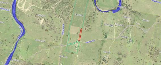
Issues
Consultation
The proposed road name will be advertised in local
newspapers, allowing a period of twenty eight days for submissions to be
received. Notice will also be sent to adjoining property owners. If no
objections are received the Geographical Names Board will be advised to arrange
gazettal.
Financial
and Resources
Council property staff will be required to complete the
public notification process.
Conclusion
Formalisation of the road name is in accordance with
Council’s Road Naming Procedure and it is therefore recommended that the
public notification process now commence to formally name the new private right
of carriageway at Candelo as Joey Lane.
Attachments
Nil
|
Recommendation
1. That Council
approve the proposal to name the new private right of carriageway located off
Slaters Lane in Candelo as Joey Lane.
2. That Council
advertise the proposed name in local media inviting submissions to the
proposal.
3. That if no
objections are received within the submission period, staff proceed with the
road naming proposal without subsequent referral to Council.
|
|
Council 20 July 2016
|
Item 11.2
|
11.2. Road closure
of a section of Council public road in Eden
Council has received an
application to close a section of Council public road located in Hopkins
Street, Eden.
Director Transport and Utilities
Background
Development application 2015.270 for the construction of
storage units on Lots 6–13, Section 1, DP 1022, Hopkins Street, Eden has
been approved by Council. In order for the applicant to comply with conditions
of the development consent, a bitumen sealed vehicular entrance must be
constructed from the end of the existing sealed road (known as Hopkins Street)
to the proposed development, including a vehicle access driveway onto the site.
The road is currently formed and used to access the site by the applicants.
In order for the applicant to construct the section of
former Crown Road, Council staff requested under Section 151 of the Roads Act
1993 for the section of road to be transferred to Council’s ownership.
Formal transfer was published in the NSW Government Gazette No 28 of 15 April
2016.
The applicant has formally applied to close and then
purchase this section of road from Council. A current market valuation has been
obtained from Opteon Property Group for the 1,960 square metre section of road
and has been valued at $17,000. A concrete causeway has been constructed by the
applicant within the road reserve and has therefore not been included for the
purpose of the valuation.
Due to the topography of the area and the steep embankment
beyond this development, the section of road reserve which is partly flood
liable will never be able to be constructed. It is therefore recommended that
Council proceed with the road closure application to Crown Lands and sale of
the road to the applicant.
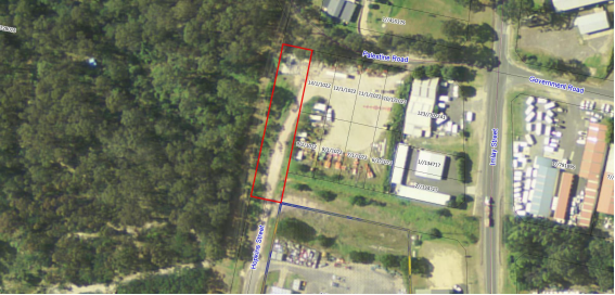
Section of road proposed to be closed.
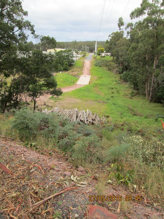
View from Palestine Road looking down at the section
of Hopkins Street proposed to be closed.
View from applicants land looking up to Palestine
Road.
Issues
Legal
If Council consent is received, staff will complete the road
closure assessment process and a road closure application will be lodged with
Crown Lands for final approval. If approved by Crown Lands and vested in
Council, a plan of first title creation will be prepared and then transferred
to the applicant, upon payment of the agreed compensation.
As per Council policy, the applicant has been required to
execute a formal deed of agreement which provides that upon transfer the road
will be consolidated with the applicants adjoining parcels of land.
Consultation
Public notification of the proposed road closure must be
completed, with a period of 28 days for submissions to be received. All
adjoining property owners are also formally advised of the proposal.
Financial
and Resources
The applicant is responsible for all costs associated with
the road closure application, subsequent transfer, their own and
Council’s legal costs incurred (capped at $1,500) to finalise this
matter. In addition to these costs, the applicant will pay Council the sum of
$17,000 (plus GST) as per the Opteon Property Group Valuation Report.
Conclusion
As all land surrounding the section of road proposed to be
closed is owned by the applicant and closure of the road would therefore not
impede access to any adjacent parcels of land, it is recommended that the Mayor
and/or General Manager be authorised to execute the necessary documents to
effect lodgement of the road closure application with Crown Lands and transfer
of the land upon closure.
Attachments
1. Opteon
Property Group Valuation Report, Portion of Closed Road, Hopkins Street, Eden
|
Recommendation
1. That
Council approve in principle the proposal received from the applicants of DA
2015.270 for the closure of a section of Hopkins Street in Eden which adjoins
their landholding and that staff be authorised to commence assessment of the
road closure application.
2. That
if no objections are received, the road closure application be lodged with
Crown Lands for formal approval.
3. That
the General Manager and/or Mayor be authorised to execute the necessary
documentation to effect the road closure and subsequent transfer of land to
the applicant for the agreed compensation and that all costs associated with
the road closure process be borne by the applicant.
|
|
Council
|
20 July 2016
|
|
Item 11.2 - Attachment 1
|
Opteon Property Group Valuation Report, Portion of Closed
Road, Hopkins Street, Eden
|

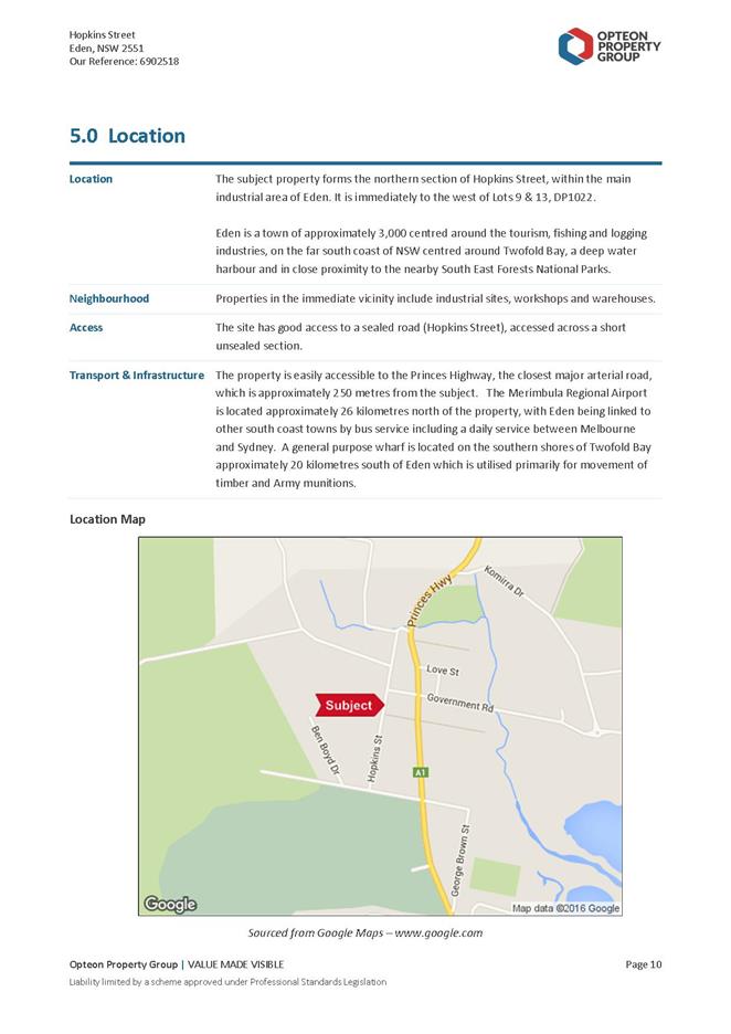
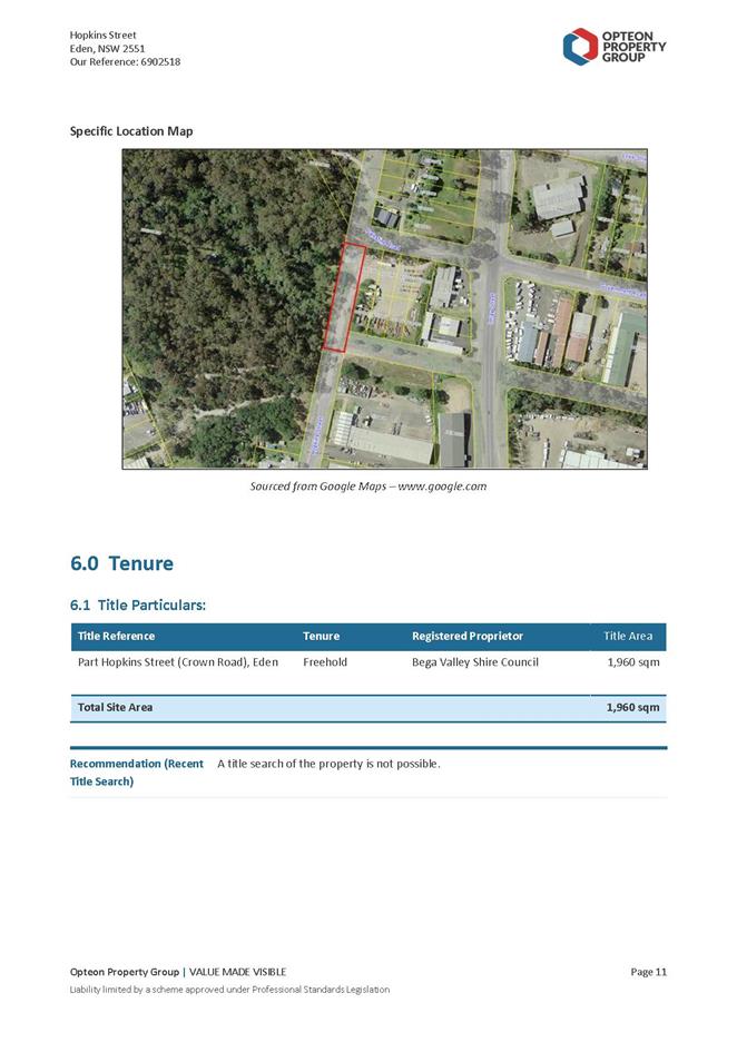
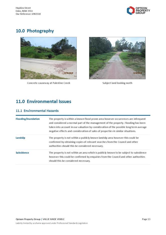
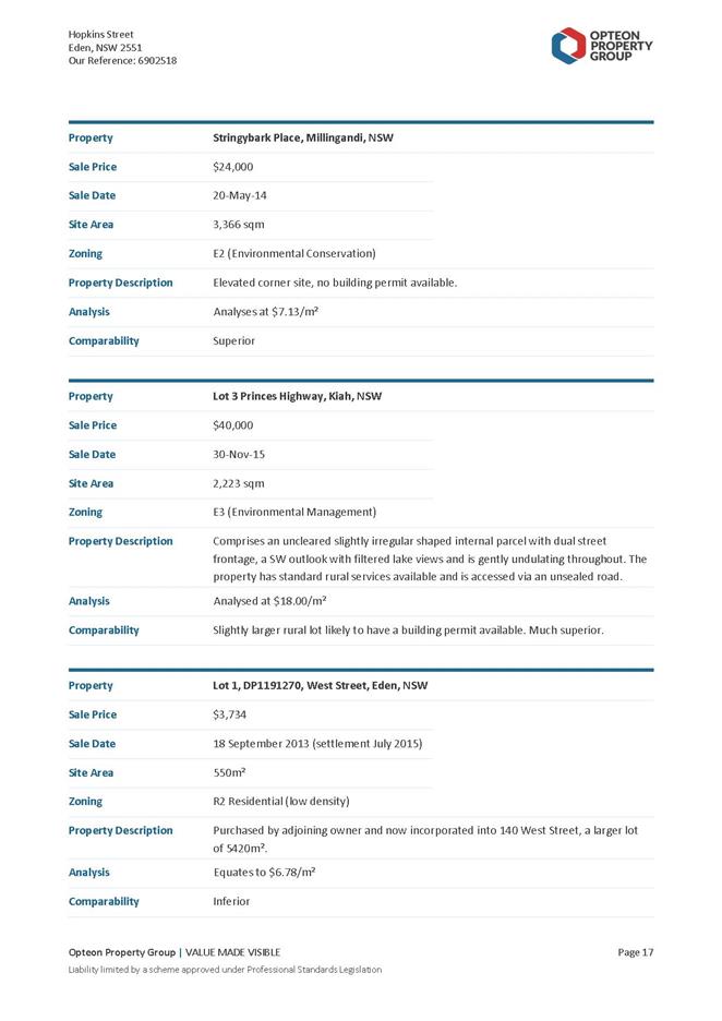
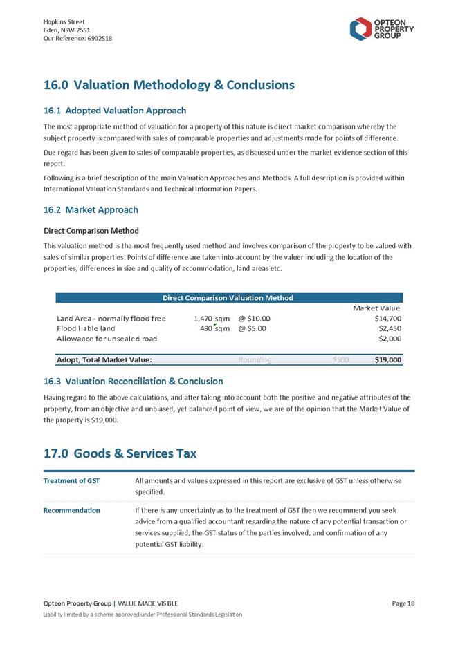
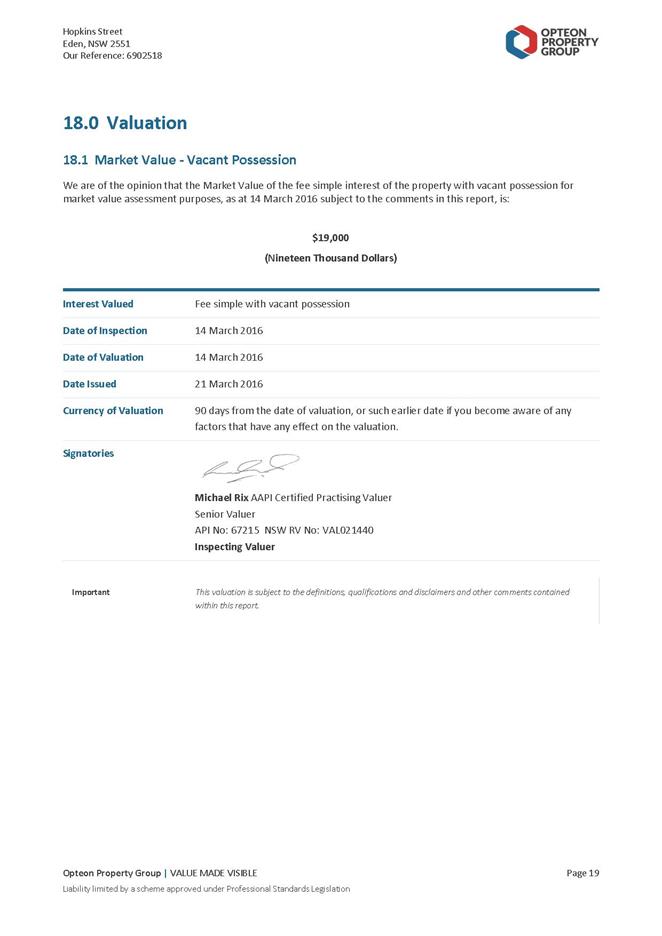
|
Council 20 July
2016
|
Item 11.3
|
11.3. Merimbula Lake
and Back Lake Flood Study - Draft Report for Public Exhibition
The draft report for
Merimbula Lake and Back Lake Flood Study has now been completed and is ready
for formal public exhibition.
Director Transport and Utilities
Background
Bega Valley Shire Council engaged consultants Cardno to
undertake a flood study for the Merimbula Lake and Back Lake catchments. The
study was undertaken to update current flood mapping, in light of recent flood
events during 2010, 2011 and 2012, with the assistance of a grant from the
Office of Environment and Heritage.
The flood study forms an initial stage towards development
of a comprehensive Floodplain Risk Management Plan, in accordance with the NSW
Floodplain Development Manual, the management of flood liable land, April 2005.
Council has taken the initiative to carry out the flood
study to assist with planning for and managing the risk the community faces
from flooding.
The Office of Environment and Heritage (OEH), is supporting
Council by providing technical assistance and administering grant funding from
the Minister for Police and Emergency Services for the project.
The draft flood study report has now been completed and
received. All computer modelling and mapping has been completed and the draft
report and findings are now ready for public comment and submissions. The final
flood study report will provide the technical basis required for the
development of a subsequent Floodplain Risk Management Study and Plan.
Issues
Legal
In accordance with Section 733 of the Local Government Act
1993, floodplain risk management in urban and rural areas in NSW is governed by
the NSW Government’s Flood Prone Land Policy and its Floodplain
Development Manual, the management of flood liable land, April 2005.
Locally, the NSW government policy is implemented through
Council’s adopted Bega Valley Local Environmental Plan 2013 and the Bega
Valley Development Control Plan 2013.
Once the final flood study report is completed, it will
provide the technical basis required for the development of a subsequent
Floodplain Risk Management Study (FRMS) and Plan (FRMP). Part of the
typical outcomes of a FRMS and FRMP are a review of structural and
non-structural flood mitigation options. Some of the typical
non-structural options arising from a FRMS and a FRMP include review of flood
related planning controls, flood prone land policies and flood related
development controls. The final mix of structural and non-structural
options are developed with the assistance of community consultation at these
subsequent stages. These outputs are then incorporated into
Council’s Environmental Planning Instruments such as Council’s
adopted Bega Valley Local Environmental Plan 2013 and the Bega Valley
Development Control Plan 2013 at that later date.
Councils issue planning certificates under Section 149 of
the NSW Environmental Planning and Assessment Act 1979 to inform potential
purchasers of planning controls and policies that then apply to the subject
land. If changes to existing, relevant, flood related planning controls,
flood related development controls or flood prone land policies do arise from
the FRMS and FRMP , the relevant wording for flood related clauses need to be
reflected in the Section 149(2) planning certificate.
A number of properties that do not have these flood related
planning and development controls currently exist. This may occur because
they are actually not flood prone according the definitions of the NSW
government’s Flood Prone Land policy or no detailed flood mapping has
been undertaken in those areas. As a result of the finalised flood study
findings, detailed flood mapping for the select study areas may then eventually
lead to a number of these properties having flood related planning and
development controls applied after the completion of the FRMS and FRMP.
Strategic
The completed flood study report will form a key technical
input document for the completion of a future floodplain risk management study
and plan. The completed flood study will allow Council to identify the existing
flood risk, hydraulic and hazard categories within the Merimbula Lake and Back
Lake catchments. The future floodplain risk management study and plan will
quantify options to manage the identified flood risks and hazards within the
flood study report. Strategic responses for land-use planning, asset planning,
emergency response planning, environmental, social and economic impact
management can then be formulated to address existing and future flood risk.
Economic
The future floodplain risk management study and plan is a
multi-disciplinary process that balances a number of differing factors to
generate recommendations for an appropriate mix of management measures to deal with
the different types of flood risk. Some typical factors considered during the
management study are the flood behaviour, danger and damage, community costs of
flooding, future land-use, a comprehensive range of flood risk management
measures, environmental needs of the river and floodplains and environmental
and cultural impacts of management measures. Cost-benefit ratios of differing
identified risk mitigation options from community consultation are developed
during a subsequent floodplain risk management study for inclusion in a
floodplain management plan for the catchment. The identified floodplain risk
management strategies are aimed at managing and mitigating flood risk where
possible to reduce the economic impact on the community. These options are
developed from the information contained within the flood study report.
Policy
The completed flood study report will provide Council with
detailed information to implement the NSW Government’s Flood Prone Land
Policy and Coastal Reforms at a local level for the catchments of interest. The
completed flood study also complies with the NSW Government Floodplain
Development Manual 2005 and standard Floodplain Risk Management (FRM) documents
from the NSW Office of Environment and Heritage and the NSW State Emergency
Service.
Operational
Plan
The completion of this project meets the Operational Plan
Key Outcome: A4.1.1 Emergency Planning: Complete Flood Study and develop
floodplain risk management plan. The associated Performance Measure is
‘Continue Merimbula Catchment Flood study’.
Environmental
/ Sustainability
Environmental concerns such as climate change, including sea
level rise, have been addressed in the draft flood study report, in accordance
with current NSW government guidelines and requirements for flood study
projects. Other environmental concerns are usually addressed in a subsequent
flood risk management study and plan following community consultation at a
subsequent time.
Asset
When finalised, the draft report findings will form the
basis of future asset/community planning and protection.
Social
/ Cultural
Floodplains are the commercial, social and environmental
arteries of the State. Transport and communication infrastructure are
often located in floodplains which, generally as the more fertile areas, are a
base for a significant proportion of the State’s agricultural business.
Regular flooding enhances agricultural productivity by increasing soil
moisture, recharging groundwater and depositing fertile silt across the
floodplain. However, flooding can also interfere with production,
communication, transport, emergency management and agricultural practices.
Therefore development and management of floodplains needs to consider a broad
range of issues, including balancing the benefits of occupying the floodplain
against the costs.
When finalised, the findings of the draft flood study will
form the basis of a future floodplain risk management study and plan that
incorporates the management of social, cultural and economic impacts.
Consultation
Consultation via formal public exhibition and the invitation
of public comment is the subject of this report. Community consultation
regarding flood study outcomes and findings are a requirement of the NSW
Government’s Flood Prone Land Policy and its Floodplain Development
Manual, the management of flood liable land, April 2005.
Consultation of local residents within the catchments was
completed using a community flood questionnaire during April-May 2015.
Consultation of relevant State agency stakeholders occurred during March
2015. Also, consultation was completed throughout the project within the
Bega Valley Shire Floodplain Risk Management Focus Group of which the
community, State agency and Council are represented.
To promote the exhibition of the draft report, letters will
be sent out to landowners within the identified floodplain areas and a media
release prepared. Two drop-in sessions with Council’s consultant
and staff will be arranged at a date to be determined for residents to raise
issues during the exhibition period. One session will occur during
business hours and one session after normal business hours.
Financial
and Resources
The flood study project is partially subsidised by
floodplain risk management programme grant of $120 000 from the Minister for
Police and Emergency Services and administered by the NSW Office of Environment
and Heritage. The grants are subsidised at a rate of two government
dollars per Council dollar.
|
Funding source
|
|
Amount
|
|
Stormwater operating
expenses
|
$
|
60 000
|
Staff and financial resources have already been expended on
delivering the Merimbula and Back Lake Flood Study project. Other resources
required will be meeting room facilities whenever any Focus Groups and/or
technical sub-committees are convened in the process of completing the flood
study project.
Conclusion
The formal public exhibition of the draft Merimbula and Back
Lake Flood Study report and findings will allow community input and submissions
to be incorporated into the final report to be adopted. The exhibition will
also allow Council to meet current NSW State Government consultation
requirements in finalising and adopting the flood study findings at the end of
the formal exhibition period.
Attachments
1. Draft
Merimbula and Back Lake Flood Study Report
|
Recommendation
1. That
Council note the draft flood study report and preliminary findings.
2. That
the draft flood study report be placed on public exhibition.
|
|
Council
|
20 July 2016
|
|
Item 11.3 - Attachment 1
|
Draft Merimbula and Back Lake Flood Study Report
|
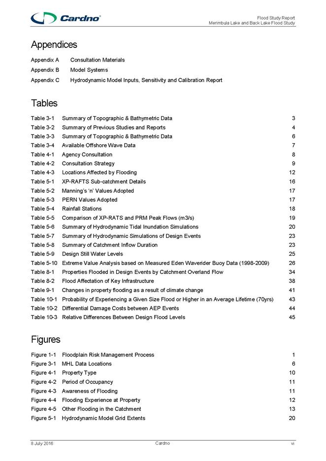
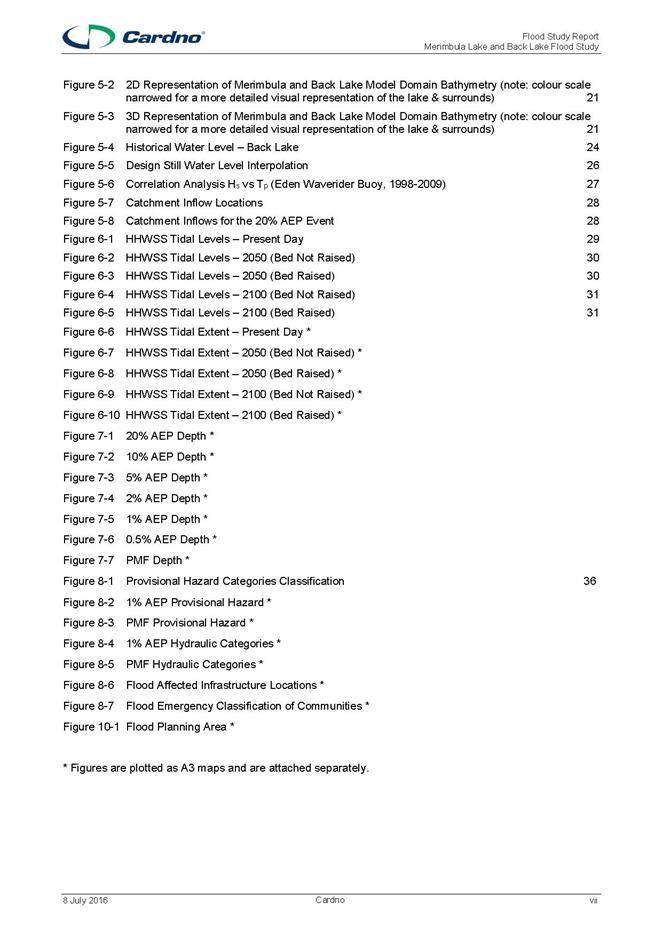
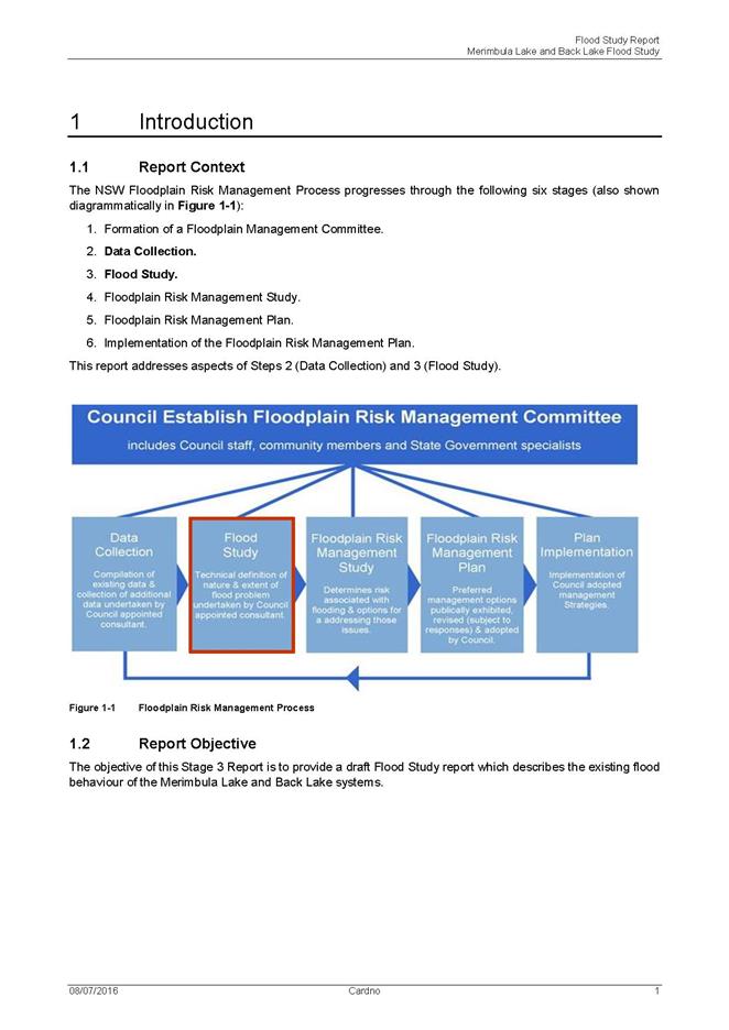
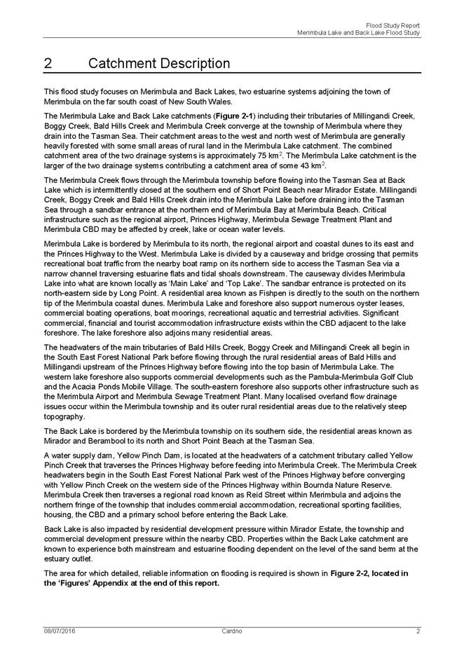
|
Council
|
20 July 2016
|
|
Item 11.3 - Attachment 1
|
Draft Merimbula and Back Lake Flood Study Report
|
|
Council
|
20 July 2016
|
|
Item 11.3 - Attachment 1
|
Draft Merimbula and Back Lake Flood Study Report
|
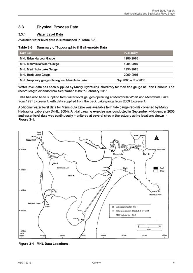
|
Council
|
20 July 2016
|
|
Item 11.3 - Attachment 1
|
Draft Merimbula and Back Lake Flood Study Report
|
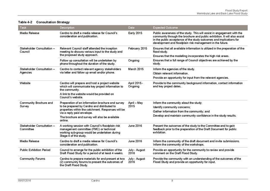
|
Council
|
20 July 2016
|
|
Item 11.3 - Attachment 1
|
Draft Merimbula and Back Lake Flood Study Report
|
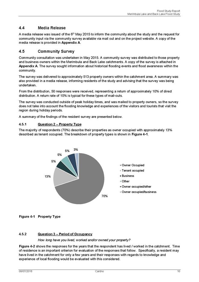
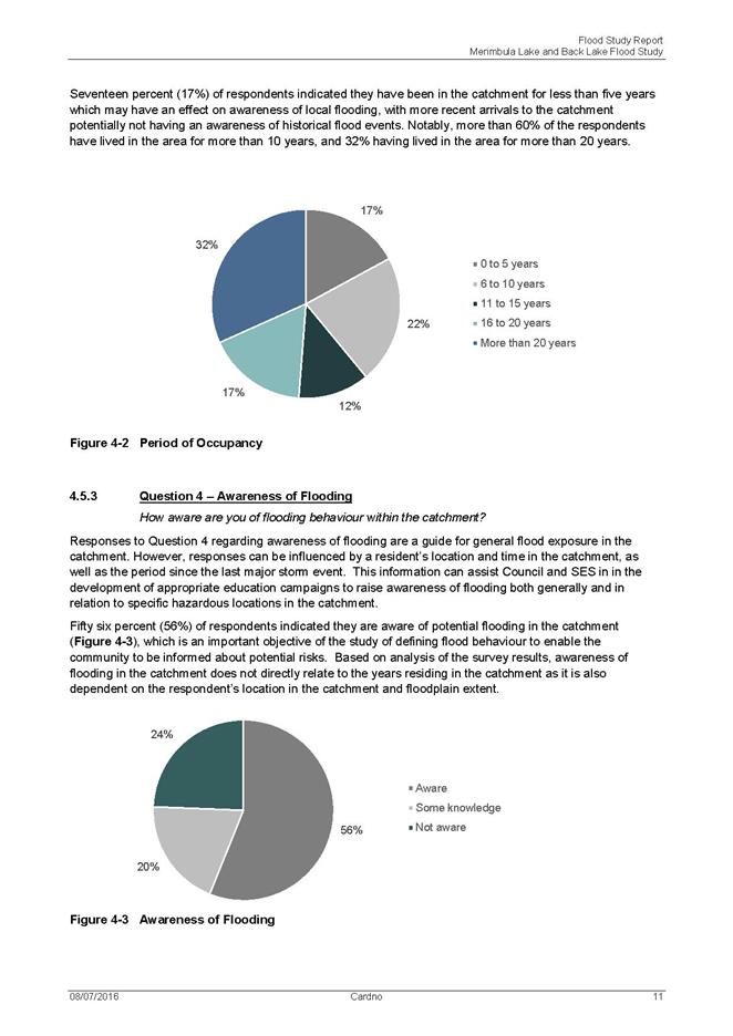
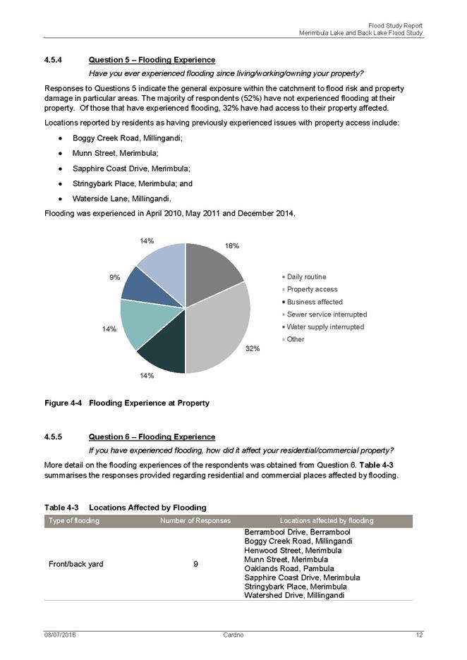
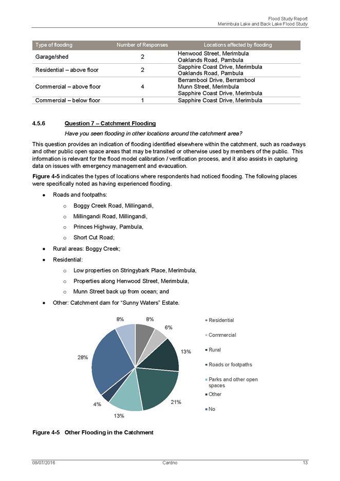
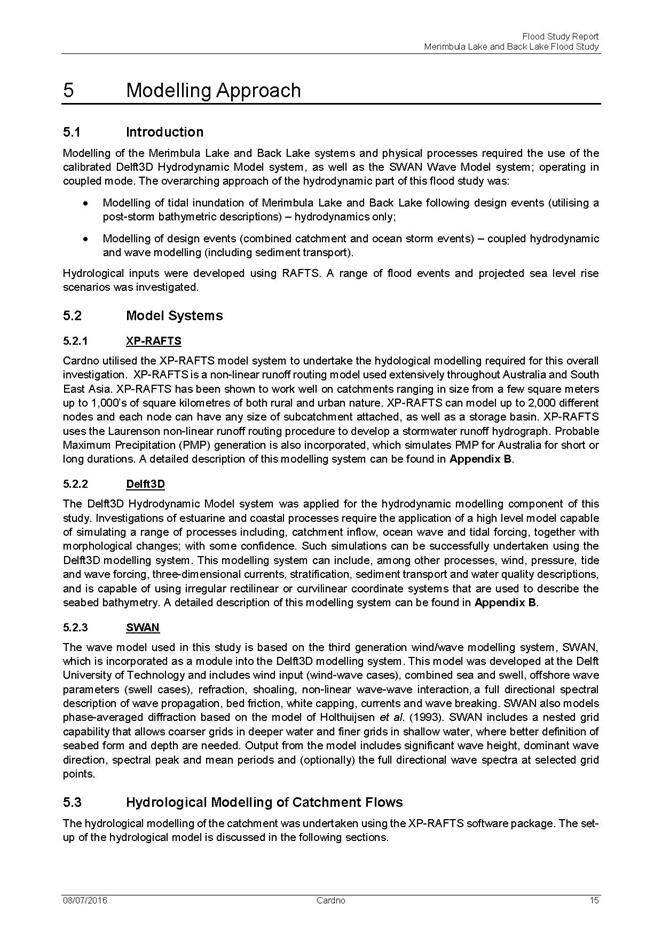
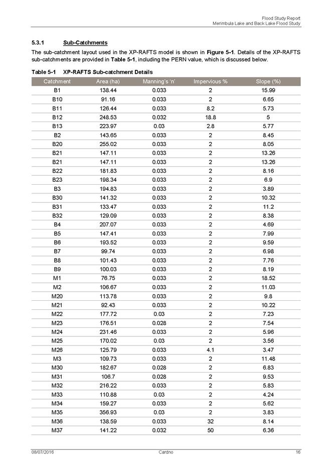
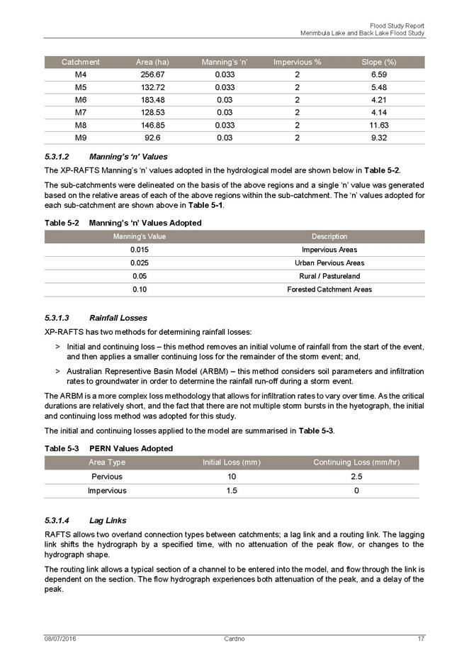
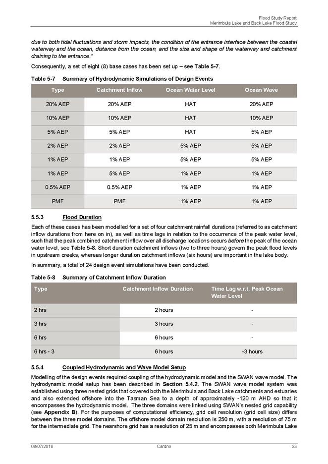
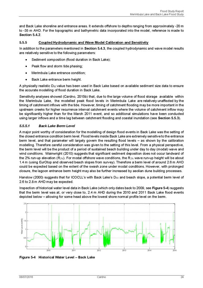
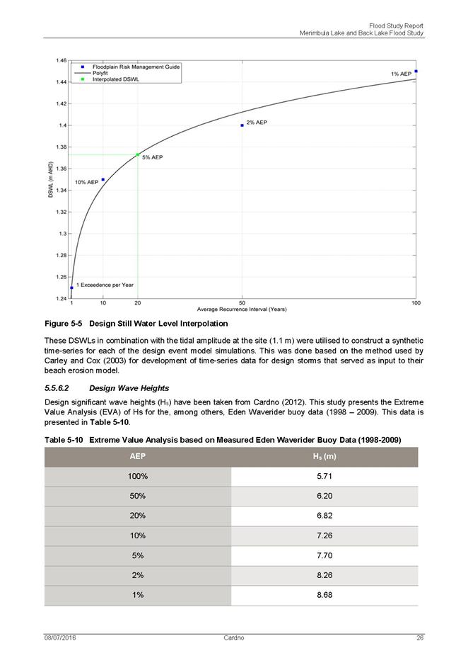
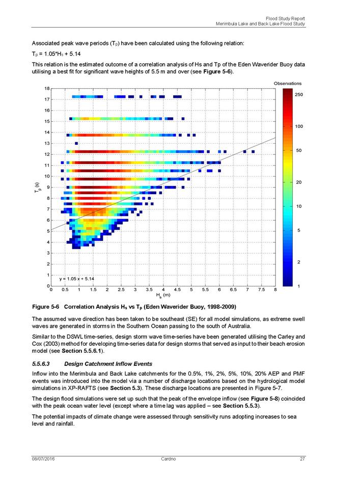
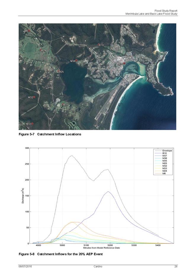
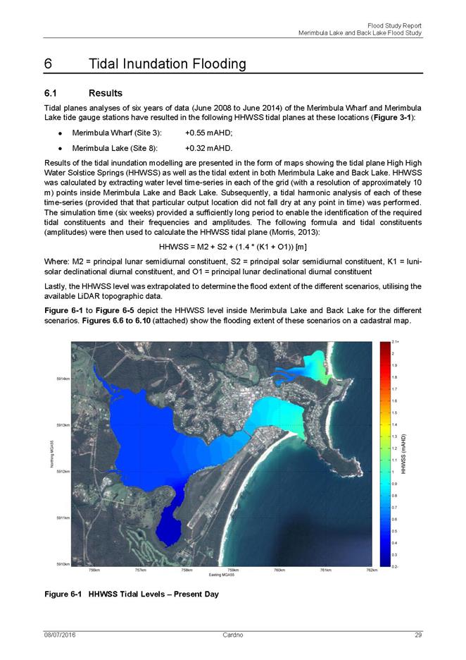
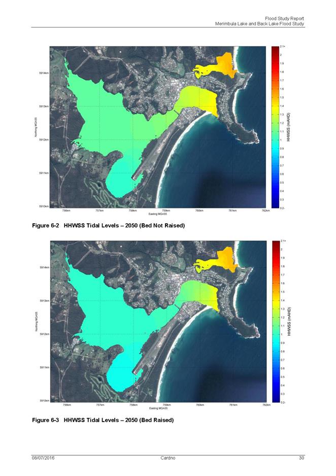
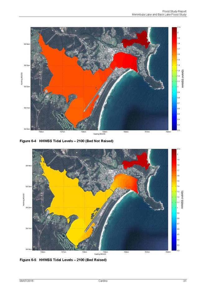
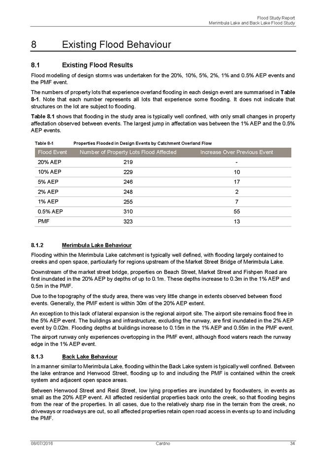
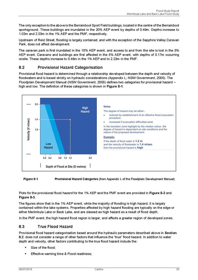
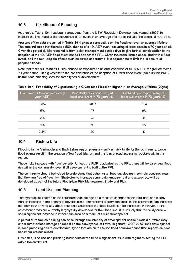
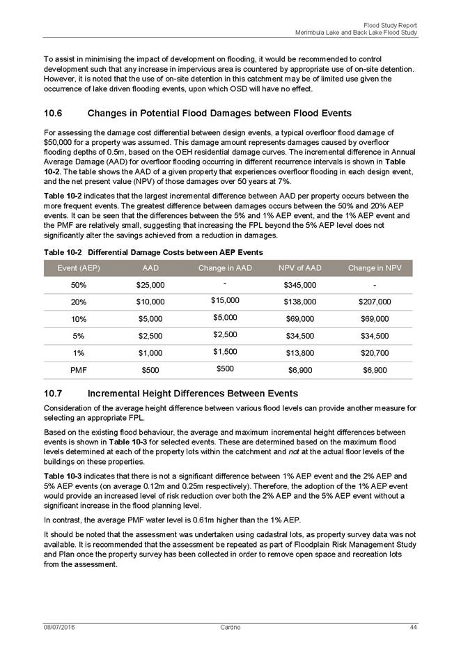
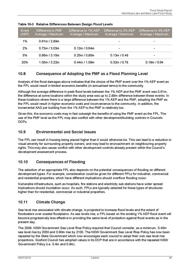

|
Council
|
20 July 2016
|
|
Item 11.3 - Attachment 1
|
Draft Merimbula and Back Lake Flood Study Report
|
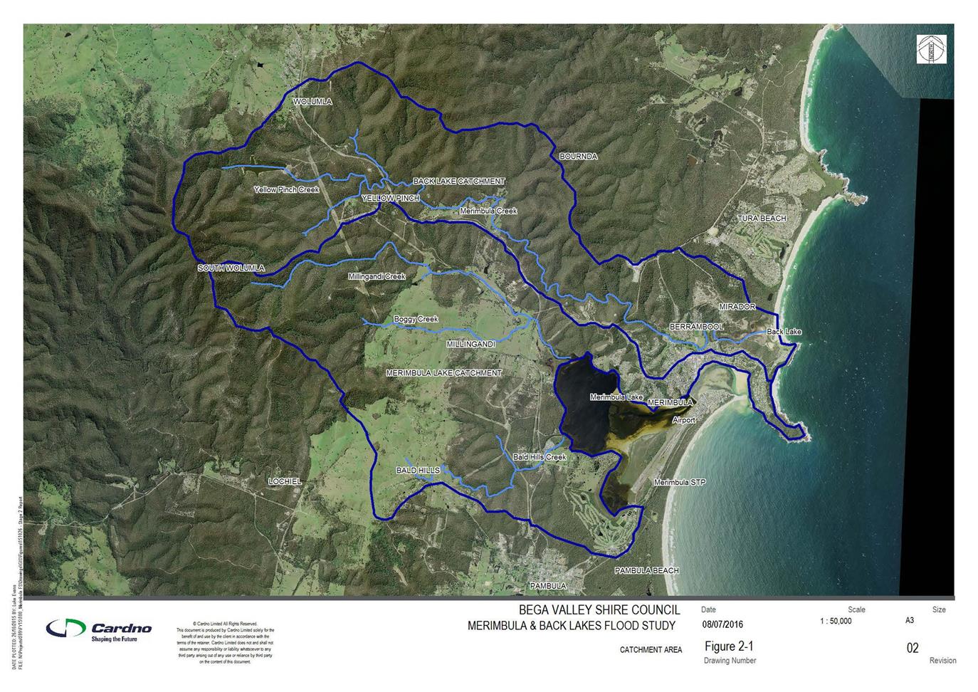
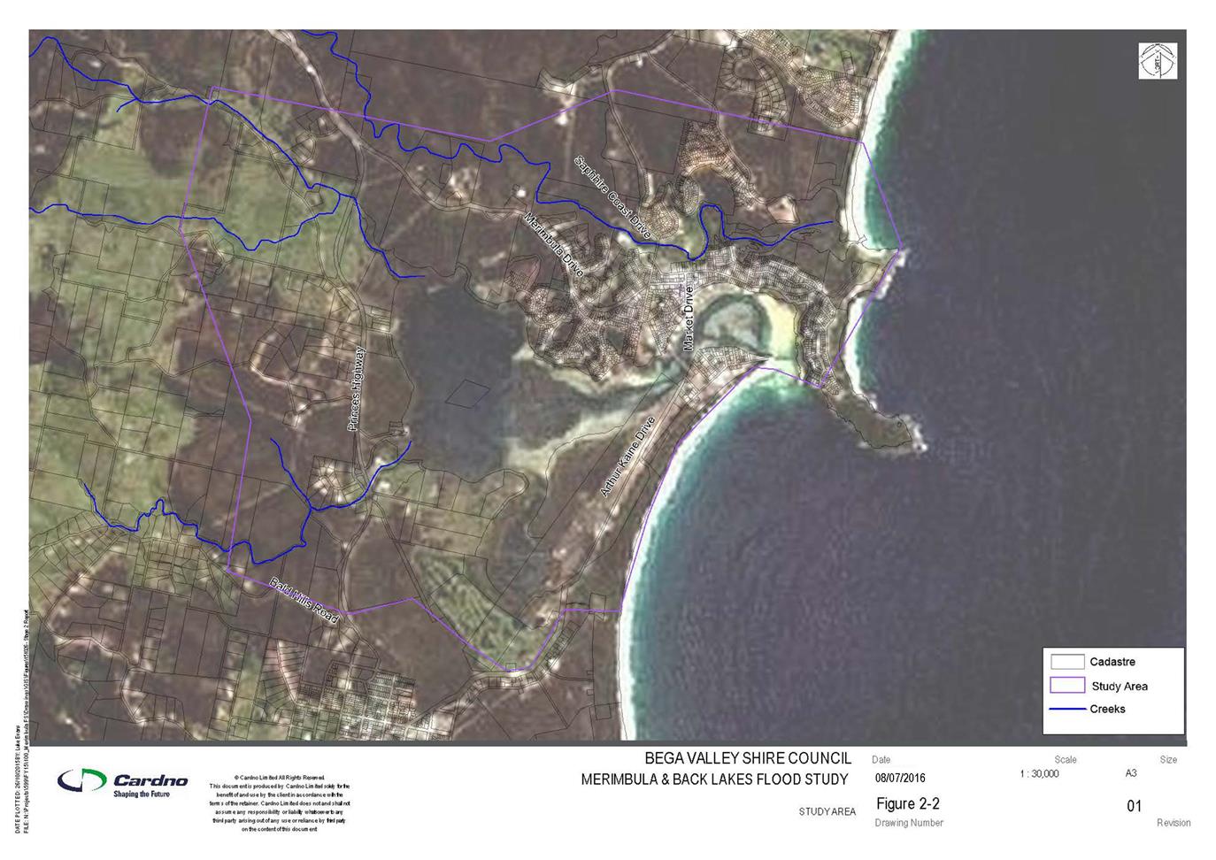
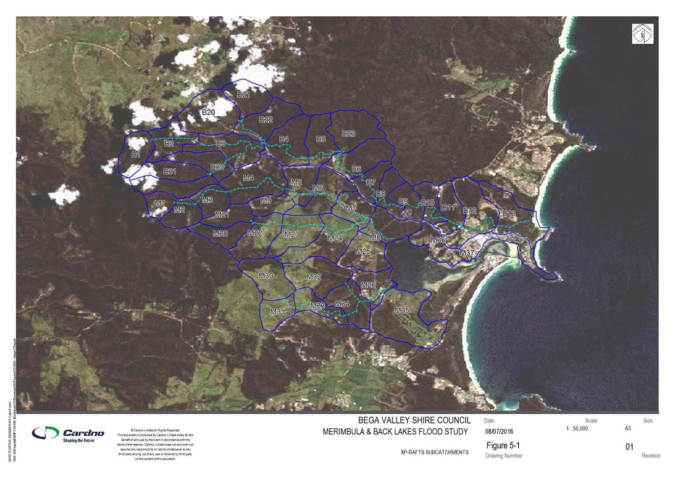
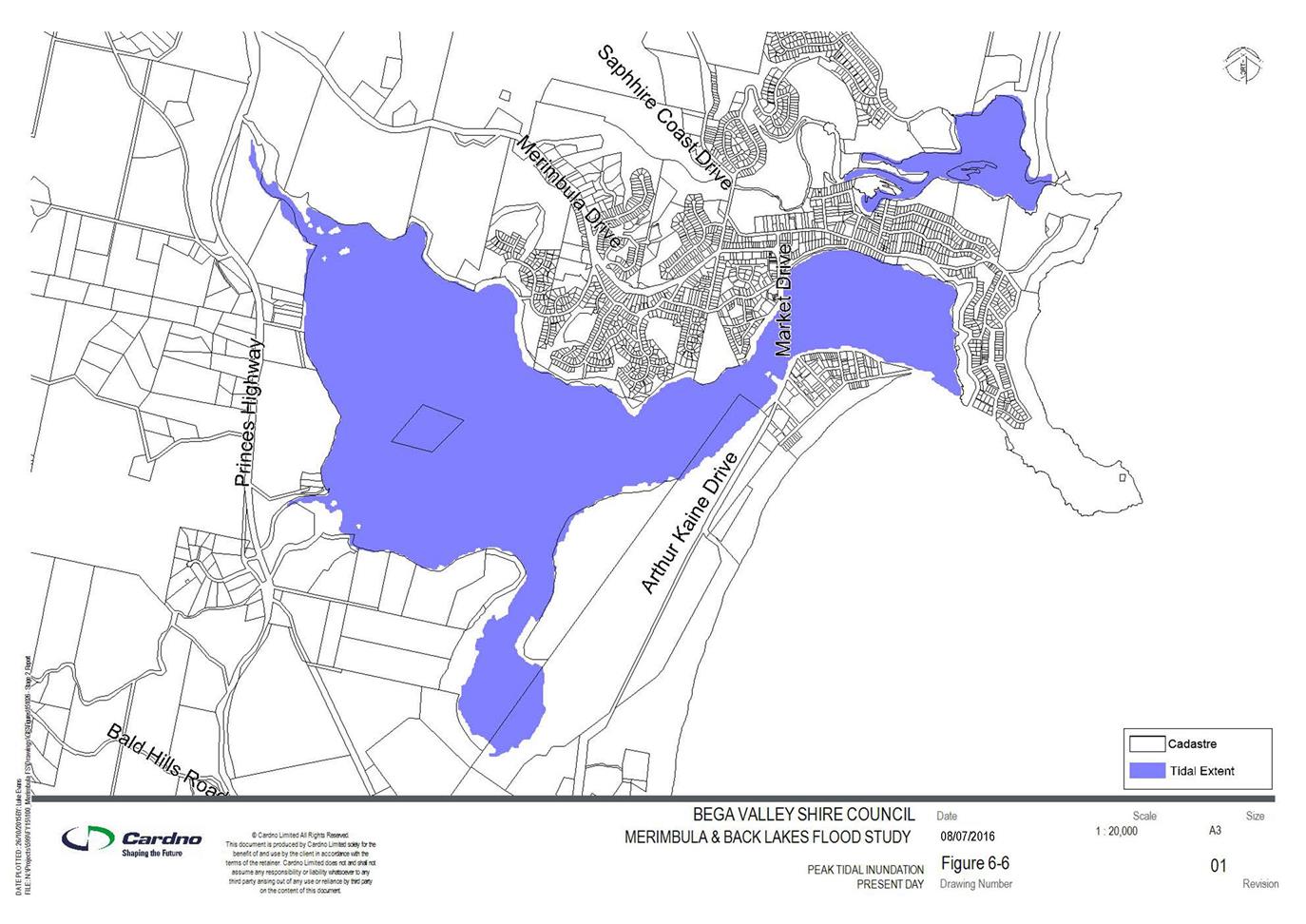
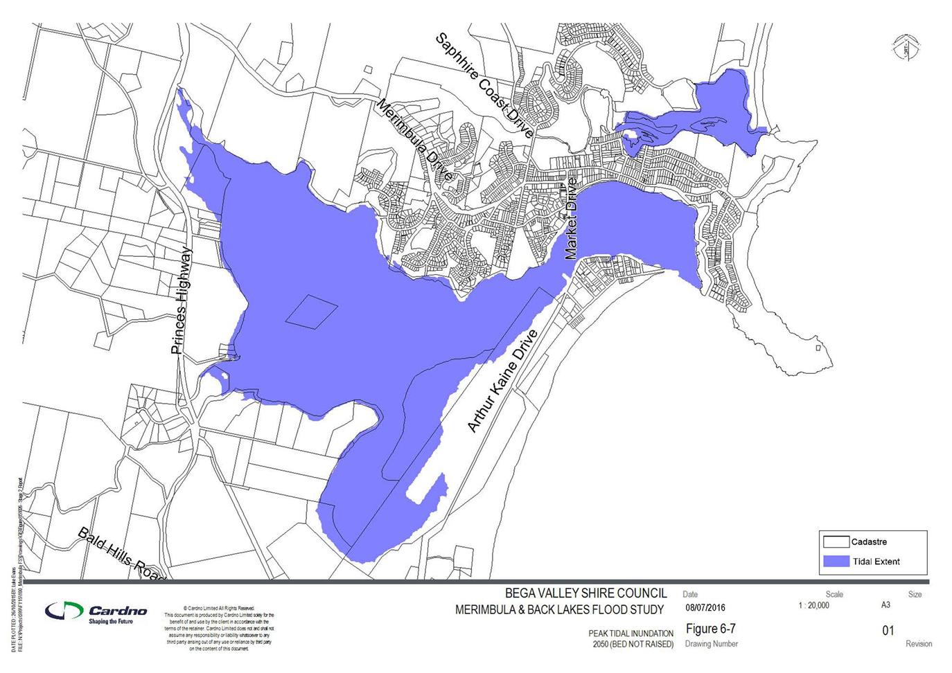


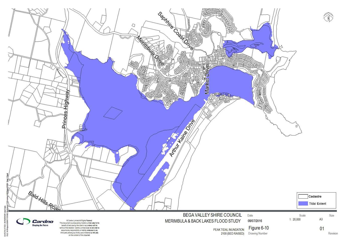
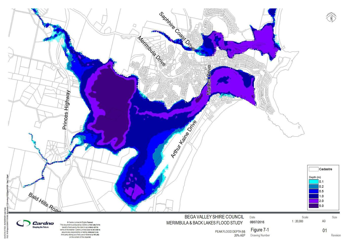

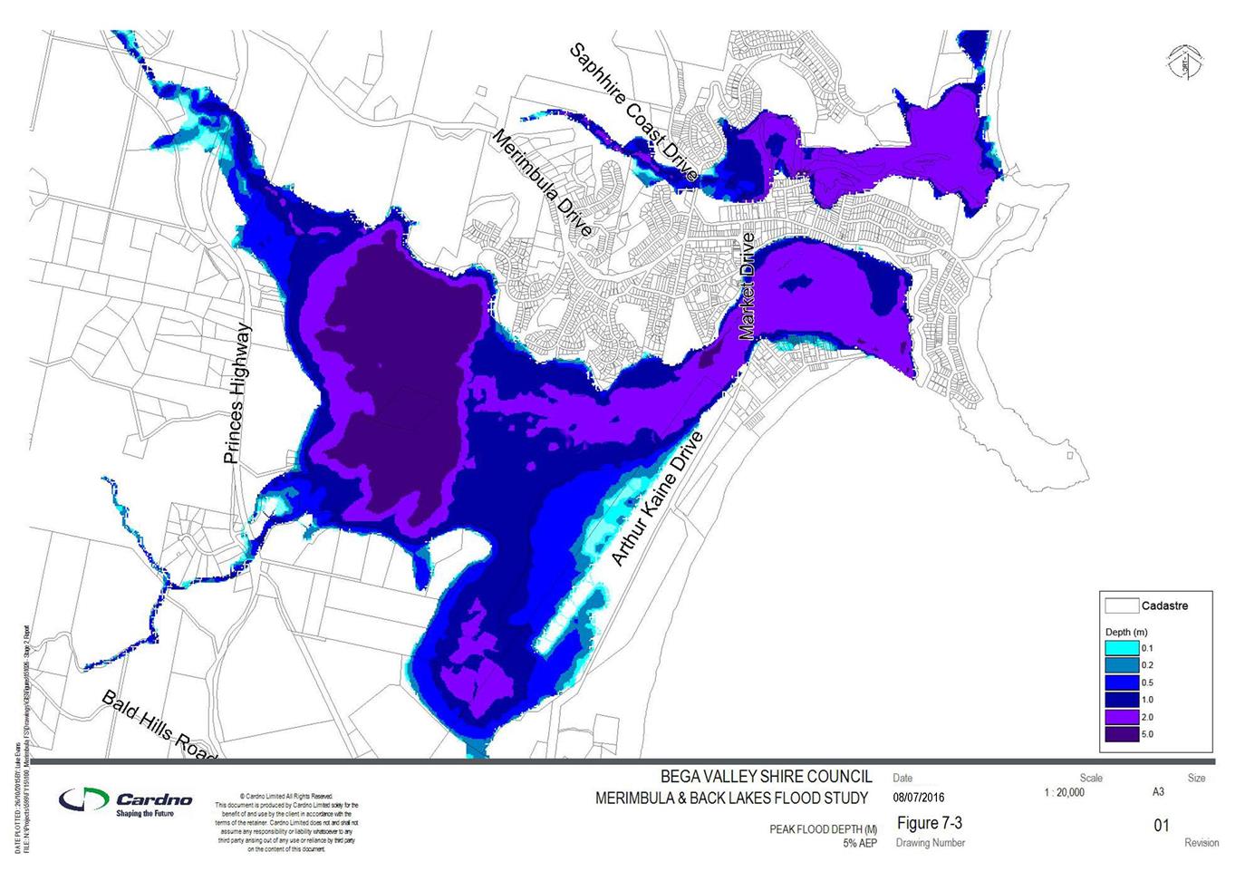

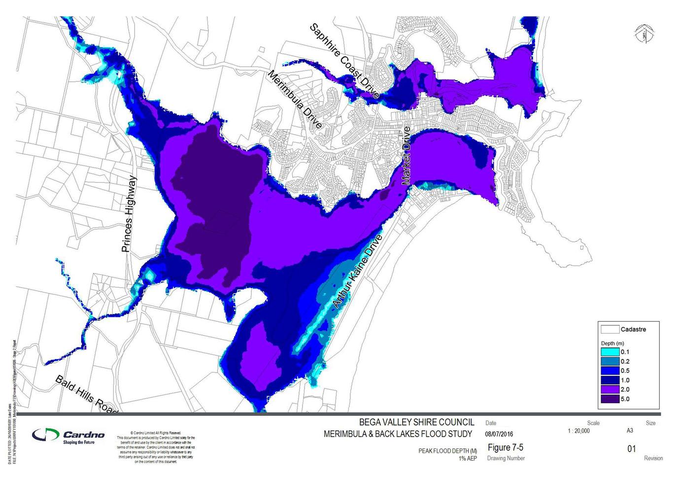
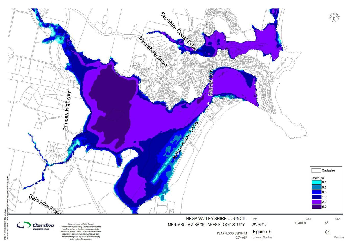
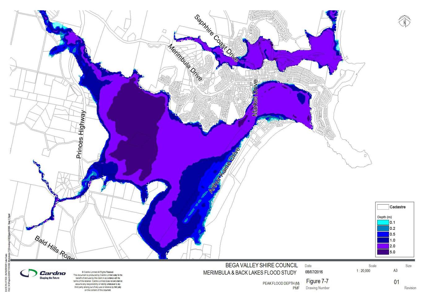
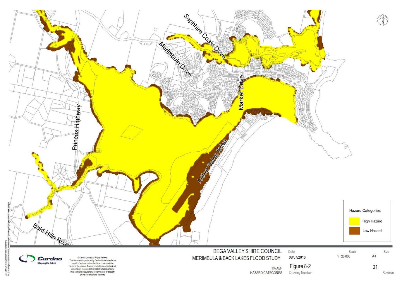
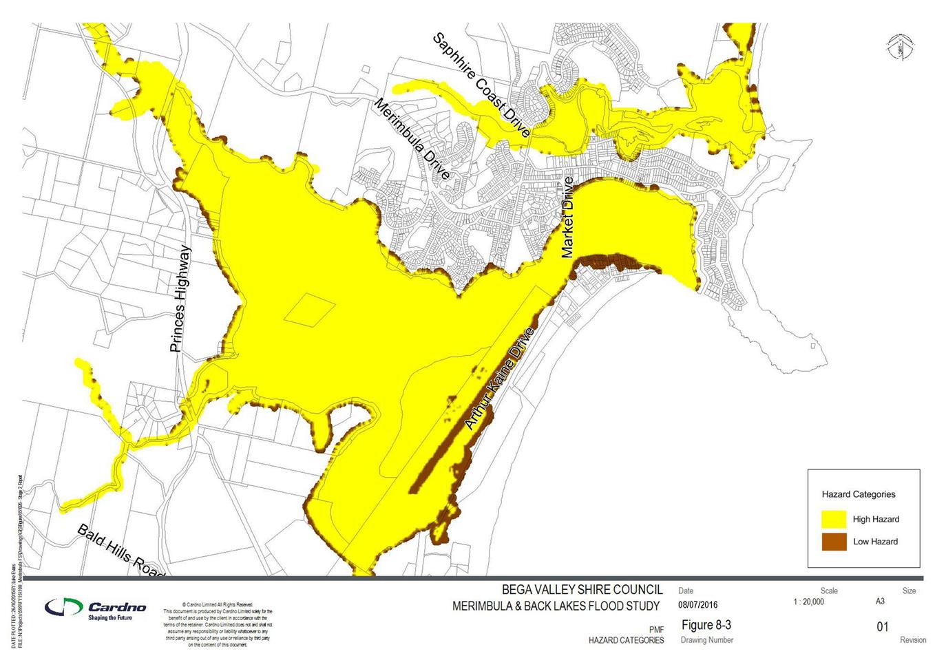
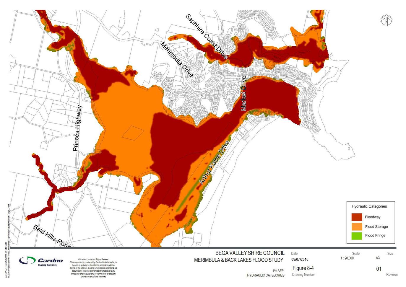
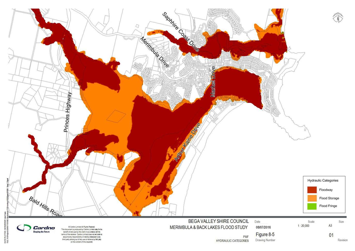
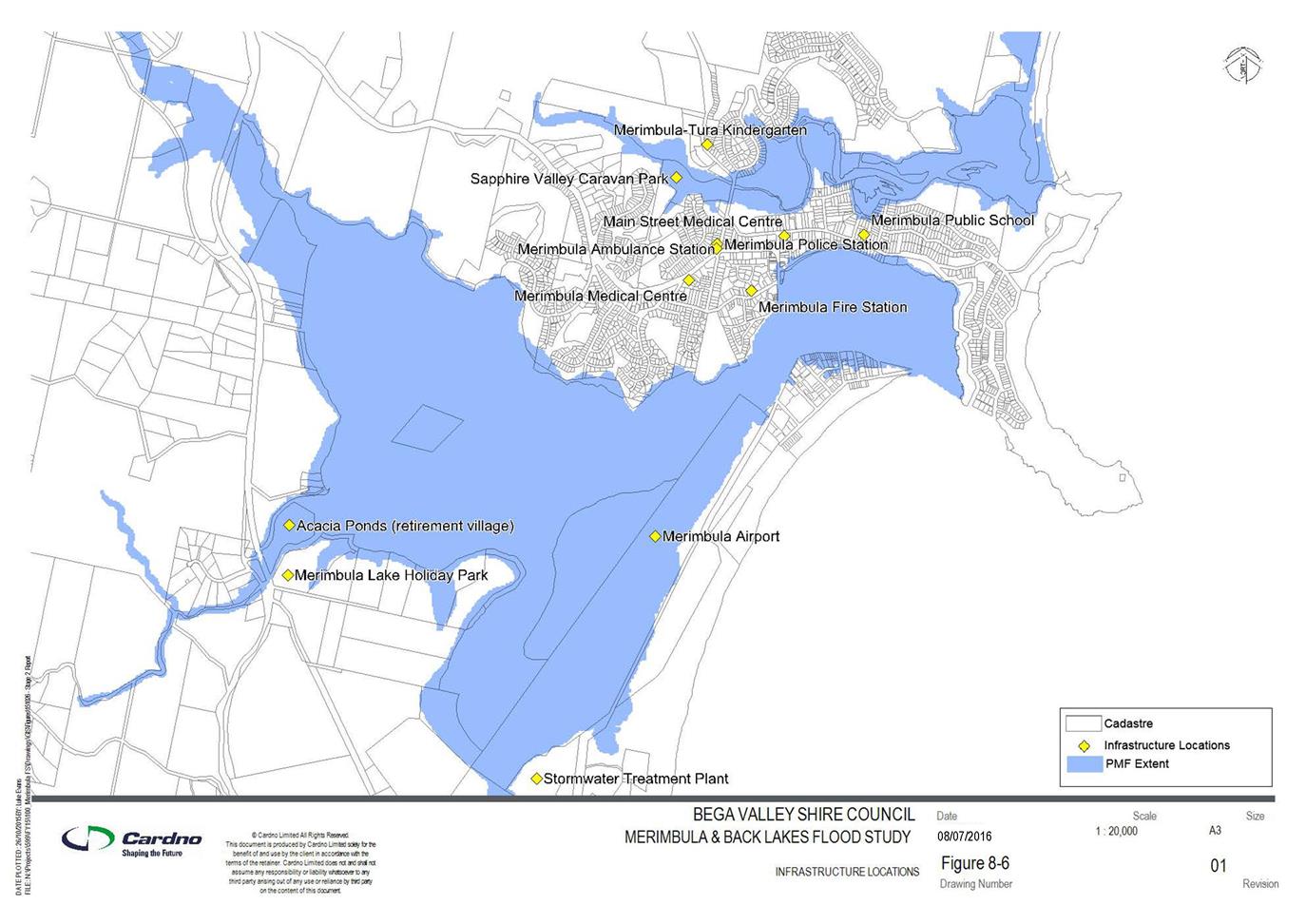
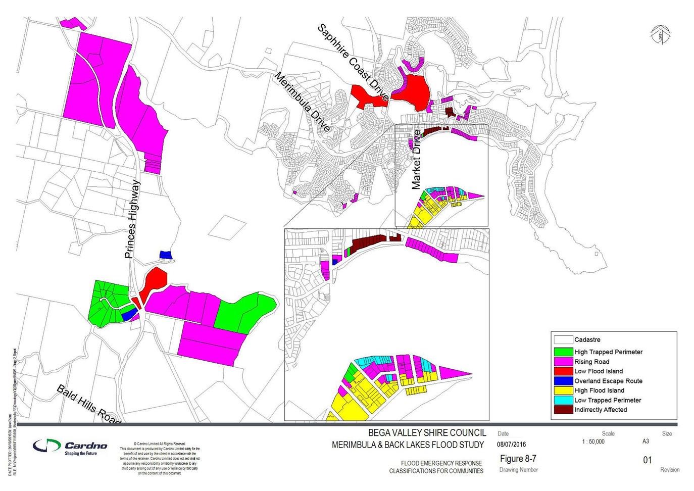
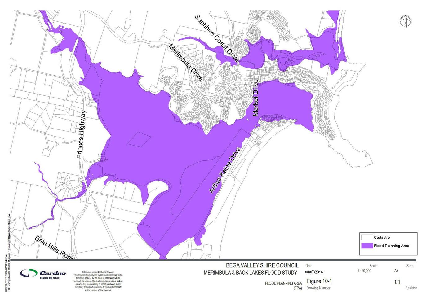
|
Council
|
20 July 2016
|
|
Item 11.3 - Attachment 1
|
Draft Merimbula and Back Lake Flood Study Report
|


|
Council
|
20 July 2016
|
|
Item 11.3 - Attachment 1
|
Draft Merimbula and Back Lake Flood Study Report
|
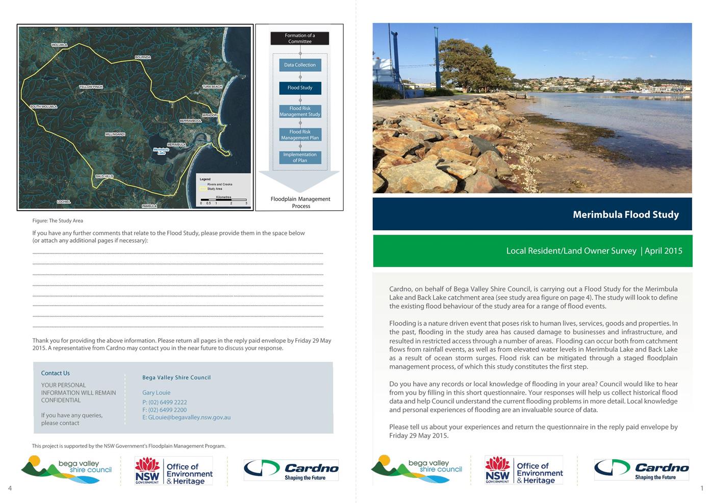
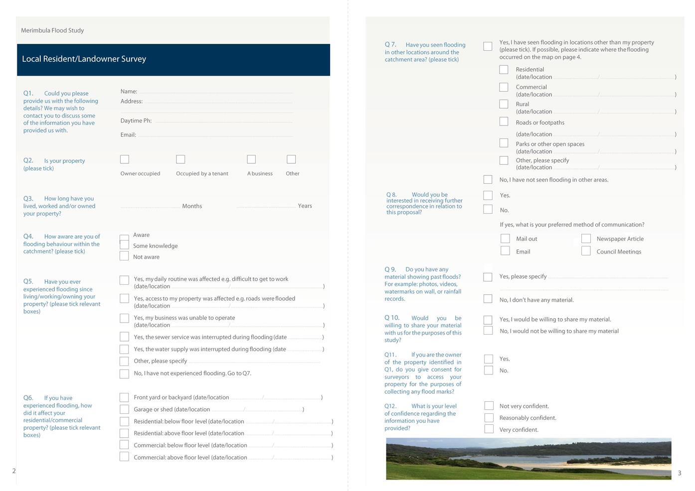
|
Council
|
20 July 2016
|
|
Item 11.3 - Attachment 1
|
Draft Merimbula and Back Lake Flood Study Report
|


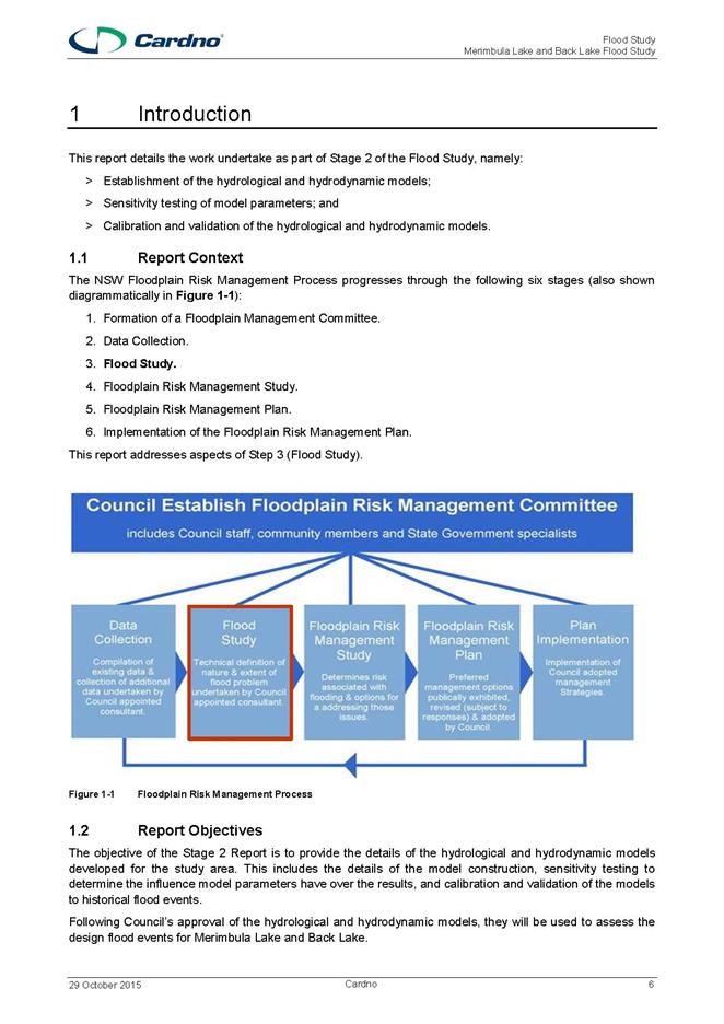
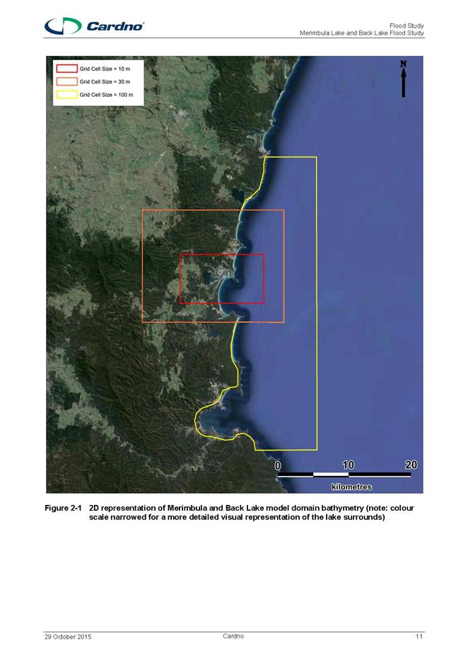
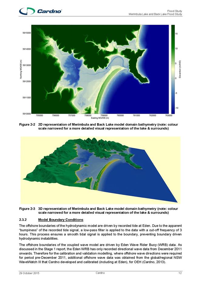
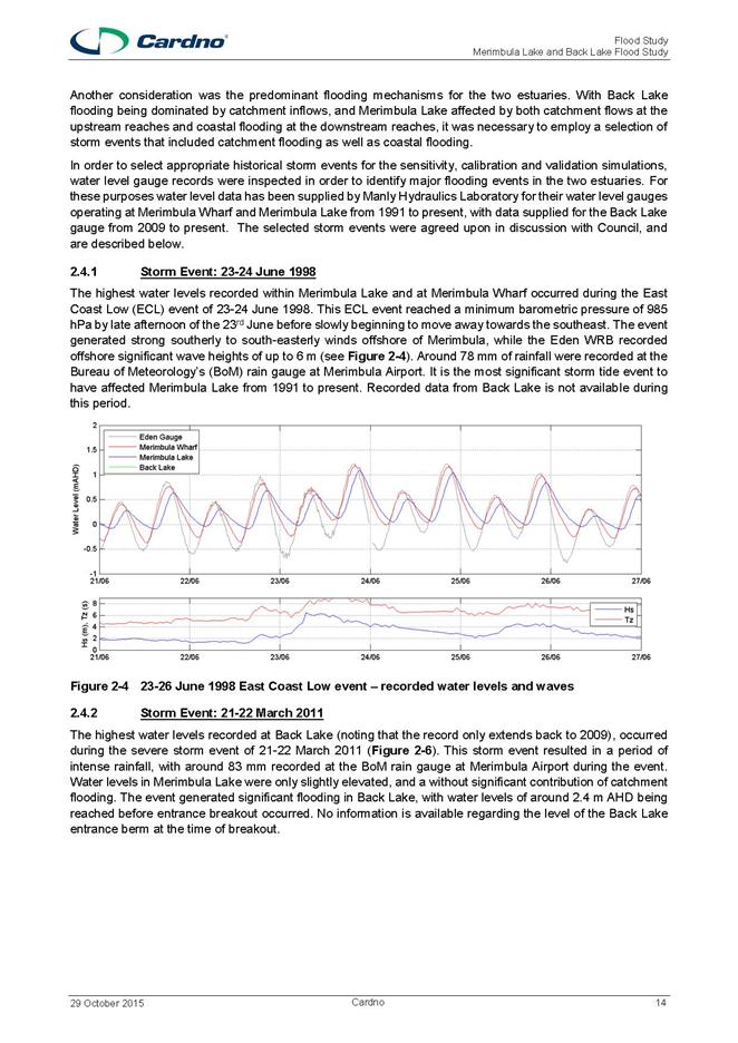
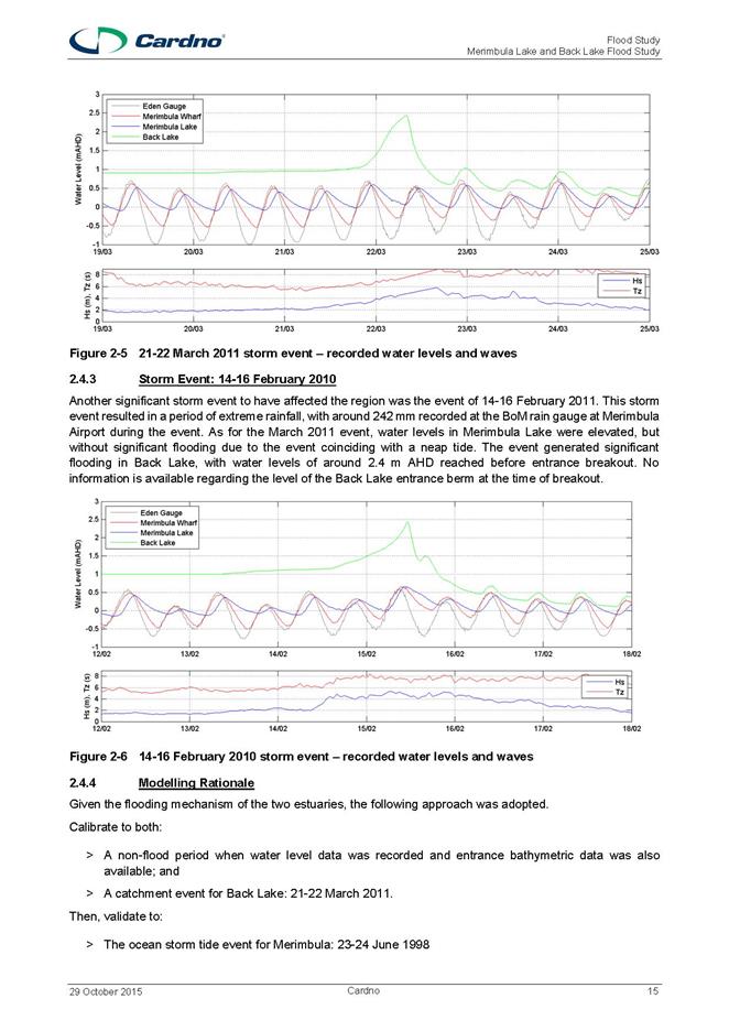
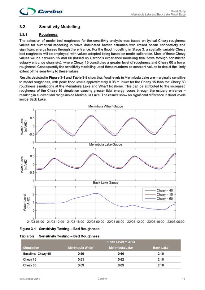
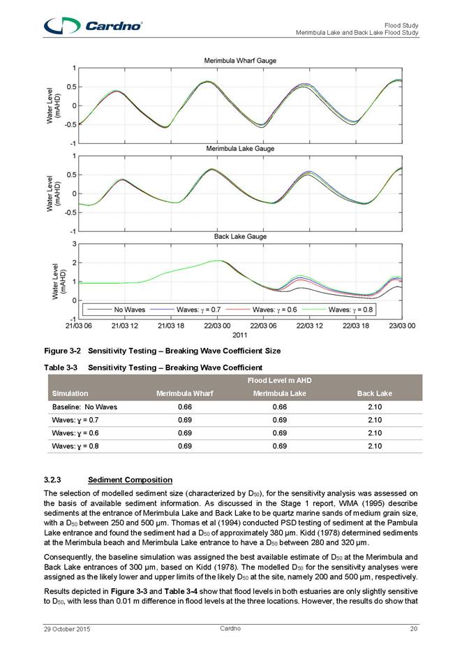
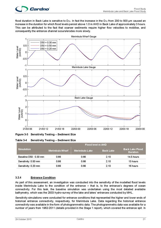
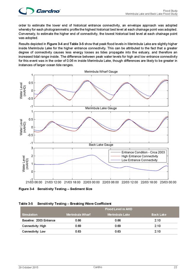
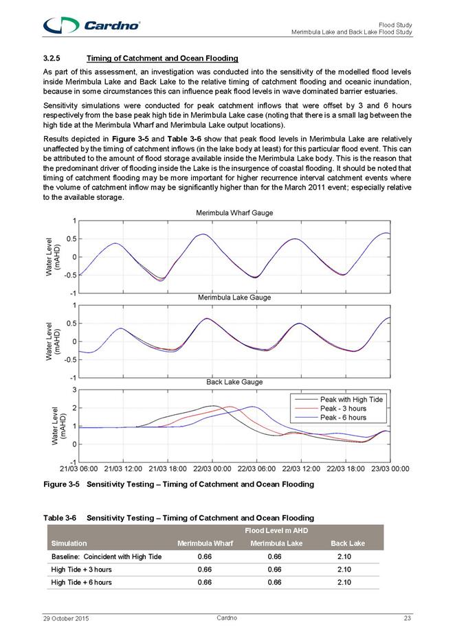
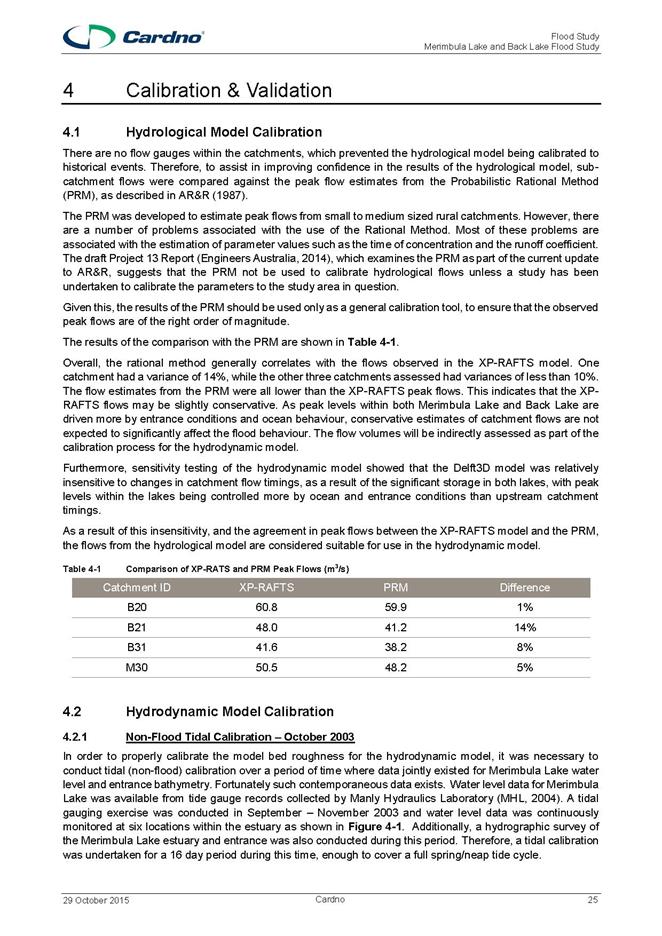
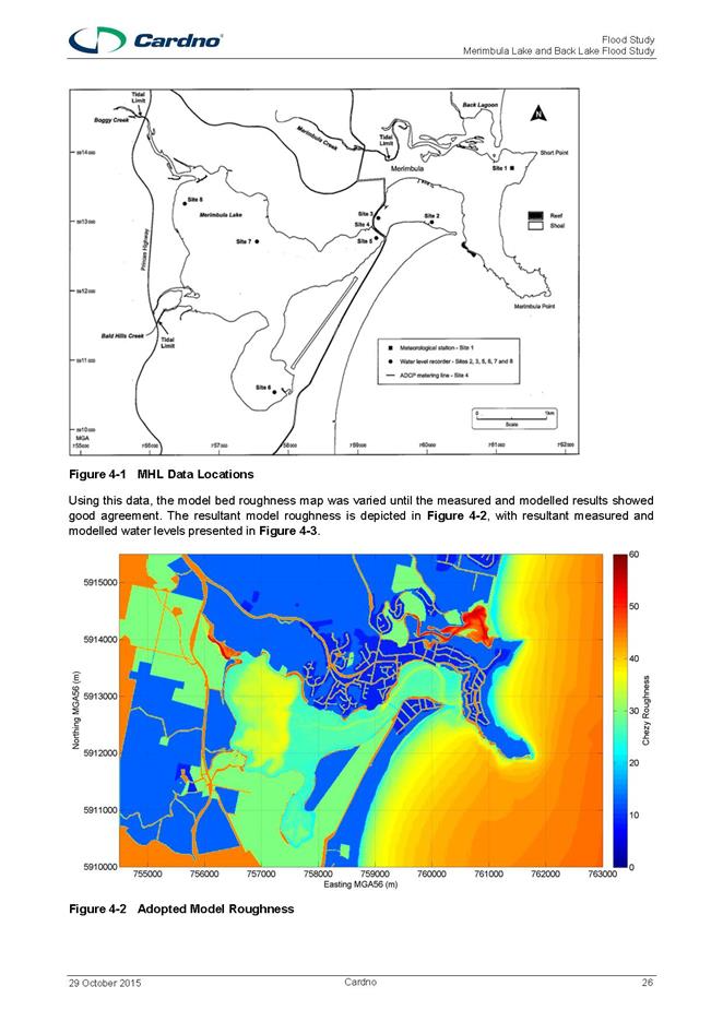
|
Council
|
20 July 2016
|
|
Item 11.3 - Attachment 1
|
Draft Merimbula and Back Lake Flood Study Report
|
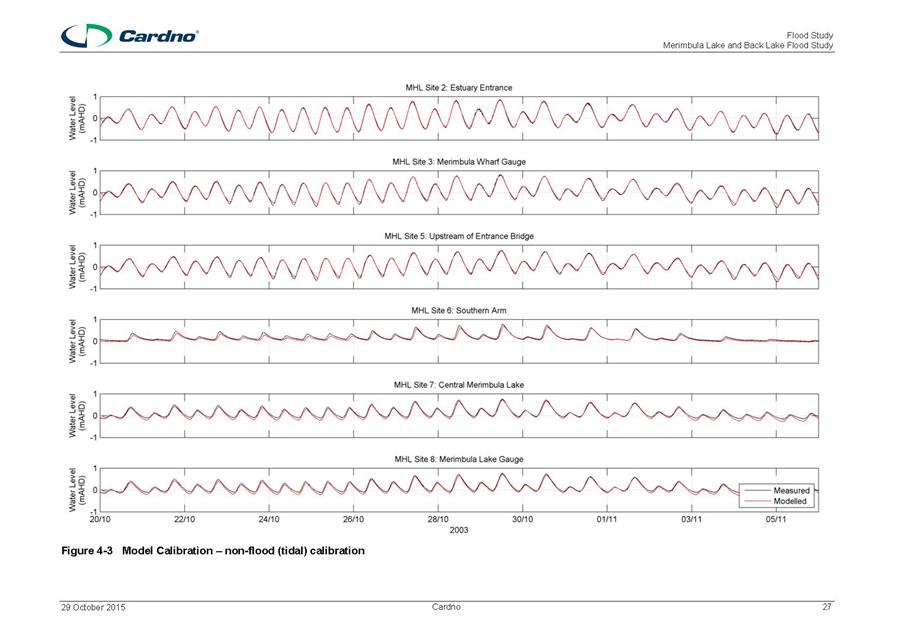
|
Council
|
20 July 2016
|
|
Item 11.3 - Attachment 1
|
Draft Merimbula and Back Lake Flood Study Report
|
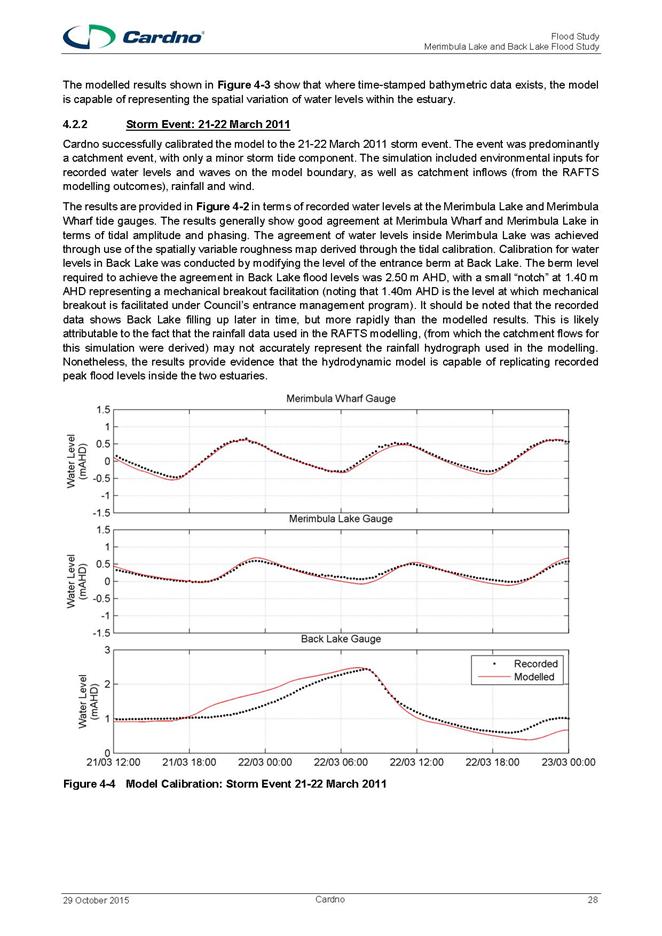
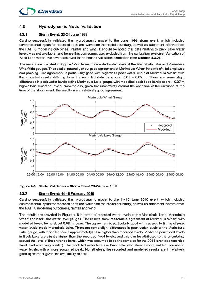
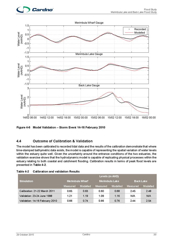
|
Council 20 July 2016
|
Item 11.4
|
11.4. Bega Valley
Local Traffic Committee - 6 July 2016
This report recommends
Council adopt the advice of the Bega Valley Local Traffic Committee from their
meeting held 6 July 2016.
Director Transport and Utilities
Background
The Bega Valley Local Traffic Committee held a meeting on 6
July 2016, the Minutes of which have been distributed separately. It is a
requirement that Council formally adopt the recommendations prior to action
being taken. The recommendations were supported unanimously by the Committee.
Attachments
Nil
|
Recommendation
That Council adopt the Bega Valley Local Traffic Committee
recommendations as follows:
Lamont
Street, Bermagui – Loading Zone
That Council approve the installation of a timed Loading
Zone from 6am to 6pm, Monday to Friday in Lamont Street, Bermagui, commencing
at a point 70.5 metres westerly from the intersection of Lamont and Montague
Streets for a length of 16.5 metres.
West
Kameruka Road – Heavy Trucks Usage
That Council approve the establishment of a 12 tonne load
limit on West Kameruka Road and Kameruka Lane.
Parking
near Intersection of Market Street and Main Street, Merimbula
That Council approve the extension of the No Stopping zone
on the northern side of Main Street, Merimbula opposite the intersection of
Main Street and Market Street by 7.5 metres, to the existing driveway of 97
Main Street, Merimbula.
Bega
Fun Run on 23 October 2016
1. That,
subject to conditions, sections of the following Council roads be temporarily
closed between 4am and 1pm on Sunday, 23 October 2016 for the Bega Fun Run:
a) Full
closure of Valley Street, Bega between the Kooringal Place and Poplar Avenue
intersections;
b) Full
closure of Kirkland Avenue, Bega between Parbery Crescent and Poplar Avenue
intersections;
c) Full
closure of Poplar Avenue, Bega between Carp Street to the end of the Valley
Fields.
d) Full
closure of Bega Street, Bega between the Poplar Avenue and Auckland Street
intersections.
e) Full
closure of Auckland Street, Bega between the Bega Street and Bridge Street
intersections.
f) Full
closure of Bridge Street, Bega;
g) Full
closure of East Street, Bega between the Bridge Street and Carp Street
intersections;
h) One
lane of Tarraganda Lane, Bega between the East Street intersection and the
Bega Country Club;
2. That
the proposed traffic arrangements for the Bega Fun Run on Sunday, 23 October
2016, be deemed a Class 2 special event and it be conducted under an approved
Traffic Control Plan, in accordance with the Roads and Maritime Services
(RMS) Traffic Control Manual.
3. That
persons involved in the preparation and implementation of the Traffic Control
Plan must hold the appropriate RMS accreditation.
4. That
organisers have approved and current public liability insurance of at least
$20 million indemnifying Council, Police and Roads and Maritime Services by
name for the event.
5. That
organisers have written Police approval prior to conducting the event.
“ReBoot
in Bermagui” Fun Run on 24 September 2016
1. That,
subject to conditions, the section of Lamont Street, Bermagui between Wallaga
Street and the Arcade be temporarily closed between 8am and 1pm on Saturday,
24 September 2016 for the ReBoot in Bermagui Fun Run.
2. That
the proposed traffic arrangements for the ReBoot in Bermagui Fun Run on
Saturday, 24 September 2016, be deemed a Class 2 special event and it be
conducted under an approved Traffic Control Plan, in accordance with the
Roads and Maritime Services (RMS) Traffic Control Manual.
3. That
persons involved in the preparation and implementation of the Traffic Control
Plan must hold the appropriate RMS accreditation.
4. That
organisers fully implement an approved Special Event Transport Management
Plan.
5. That
organisers have approved public liability insurance of at least $20 million
indemnifying Council, Police and Roads and Maritime Services by name for the
event.
6. That
organisers have written Police approval prior to conducting the event.
7. That
organisers ensure all necessary use of land approvals are in place prior to
conducting the event.
Tathra
Mountain Bike Enduro on 27-28 August 2016
1. That,
subject to conditions, the on-road components for the Tathra Mountain Bike
Enduro on Saturday, 27 August 2016 and Sunday, 28 August 2016 be approved.
2. That
the event be deemed a Class 2 special event and it be conducted under an
approved Traffic Control Plan in accordance with the Roads and Maritime
Services (RMS) Traffic Control Manual.
3. That
the Traffic Control Plan is to reflect the following:
a) All
stages held on Tathra Bermagui Road to be transport stages only, including
race finish.
b) Use
of cycle track is not available for racing purposes, as it is set aside for
casual users.
4. That
persons involved in the preparation and implementation of the Traffic Control
Plan must hold the appropriate RMS accreditation.
5. That
organisers fully implement an approved Special Event Transport Management
Plan.
6. That
organisers have approved public liability insurance of at least $20 million
indemnifying Council, Police and Roads and Maritime Services by name for the
event.
7. That
organisers have written approval prior to conducting the event from the
following:
a) NSW
Police, under Section 115 of the Road Transport Act 2013; and
b) National
Parks and Wildlife Service.
8. That
the event organisers advertise the change to traffic conditions for the
event.
9. That
local emergency services and transport operators be notified prior to the
event.
|
|
Council 20 July 2016
|
Item 11.5
|
11.5. RFT 42/16
Watermains Renewals and/or Upgrades 2016-2018
This report details the
outcomes of evaluation of Tender 42/16 for the supply and construction of water
mains renewals and/or upgrades for 2016/17 and 2017/18 and recommends award to
the preferred tender.
Director Transport and Utilities
Background
Bega Valley Shire Council provides drinking water to
nineteen towns and villages in the Bega Valley Shire Local government area and
to two villages in the Eurobodalla Shire. Council, as the local water utility,
is responsible for providing safe, reliable and affordable drinking water to
customers.
As part of these responsibilities, Council has an ongoing
water mains replacement program. The works proposed include construction of new
water mains in the general location shown on the contract drawings.
This tender is for works through to June 2018. Notionally
this timeframe constitutes a two-year contract. Council have provided a minimum
indicative program of works for the first year (2016/2017 Financial Year (FY)).
The fee for these works was expressed to Council in a schedule of rates. This
schedule of rates will be used for amendments to the indicative program of
works, as well as for the entirety of the second year of the contract.
The second year of the contract (2017/2018 FY) will be
defined in Q2 2017 and will be similar in value to the 2016/2017 program of
works (as indicatively defined in this tender).
Issues
Environmental
/ Sustainability
Council has engaged a suitably qualified consultant to
complete a Review of Environmental Factors associated with the works.
Asset
The renewal works are being undertaken in accordance with
the aims of the Water Supply Asset Management Plan.
Consultation
Community consultation will be undertaken prior to works
commencing and thereafter during construction.
Financial
and Resources
This project is funded from the annual renewals budget to
maintain acceptable levels of service for our customers.
Conclusion
Five organisations submitted offers for consideration. The
Tender Evaluation Committee assessed all tenders submitted and determined the
preferred tenderer according to the tender evaluation plan.
Council officers recommend the preferred tenderer be
accepted as they have been assessed as providing the best overall value to
Council.
Attachments
1. Confidential
memorandum to Councillors regarding RFT 42/16 for the supply and construction
of watermains renewals and/or upgrades for 2016/17 and 2017/18 (Councillor
Only) (Confidential)
|
Recommendation
1. That
Council accepts recommendations as outlined in the Confidential attachment.
2. That
Council accept the Tender from (insert) in relation to the contract for the
works described in Tender 42/16 for the supply and construction of water
mains renewals and/or upgrades for 2016/17 and 2017/18 Financial Years, in
the amounts specified in the schedule of rates submitted and any subsequent
addenda or clarifications completed as part of the assessment process.
3. That
authority is delegated to the General Manager to execute all necessary
documentation.
4. That
other tenderers be advised of Council’s decision.
|
|
Council 20 July 2016
|
Item 11.6
|
11.6. RFT 19/16
Rehabilitation and restoration of sewer manhole structures 2016/17 and 2017/18
This
report details the outcomes of evaluation of Tender 19/16 for the
rehabilitation of sewer manhole structures for the 2016/2017 and 2017/2018
financial years and recommends award to the preferred tender.
Director Transport and Utilities
Background
Council manages ten sewerage reticulation systems and
proposes to carry out rehabilitation work on approximately 200 manholes
identified as being in poor condition.
The majority of the work will be undertaken on the Eden and
Bega sewerage systems which currently experience high rates of inflow and
infiltration. The work will include structural relining of the manholes
inclusive of plant, labour and materials.
Council invited tenders for this work on 5 May 2016 through
advertisements on Tenderlink, as well as in local media and the Sydney Morning
Herald. At the close of the tender period on 1 June 2016, nine submissions were
received.
The tender submissions were assessed against the following
evaluation criteria and weightings:
|
Criteria
|
Weighting
|
|
Price
|
60%
|
|
Project Experience
|
15%
|
|
Project Functionality
|
20%
|
|
Local Community Benefit
|
5%
|
|
WH&S
|
Compliant / Non-Compliant
|
|
Total
|
100%
|
Issues
Legal
The procurement/tender process complies with the Local
Government Act 1993.
Environmental
/ Sustainability
The works will help meet NSW Environment Protection
Authority (EPA) regulatory requirements associated with operation and
maintenance of sewerage reticulation systems.
Asset
The renewal works are being undertaken in accordance with
the aims of the Sewerage Asset Management Plan.
Consultation
Community consultation will be undertaken prior to works
commencing and thereafter during construction.
Financial
and Resources
The project is funded under the Sewer Infrastructure –
general renewals program.
Council officers will manage the project.
Conclusion
Nine organisations submitted tenders for consideration. The
Tender Evaluation Committee assessed all tenders submitted and determined the
preferred tenderer according to the tender evaluation plan.
Council officers recommend the preferred tenderer be
accepted as they have been assessed as providing the best overall value to
Council.
Attachments
1. Confidential
memorandum to Councillors regarding RFT 19/16 for rehabilitation and
restoration of sewer manhole structures in 2016/17 and 2017/18 (Councillor
Only) (Confidential)
|
Recommendation
1. That
Council accepts recommendations as detailed in the Confidential attachment.
2. That
Council accept the tender from (insert) in relation the contract for works as
described in Tender RFT 19/16 Rehabilitation and Restoration of Sewer Manhole
Structures 2016/2017 and 2017/2018 financial years, as described in the
schedule of rates.
3. That
authority is delegated to the General Manager to execute all necessary
documentation.
4. That
other tenderers be advised of Council’s decision.
|
|
Council 20 July 2016
|
Item 11.7
|
11.7. RFT 49/16
Condition Assessment of Water and Sewerage Facilities
This report details the
outcomes of evaluation of Tender 49/16 for the provision of consultant services
to conduct a condition assessment of water and sewerage facilities and
recommends award to the preferred tender.
Director Transport and Utilities
Background
Council provides reticulated water to 19 towns and villages
in the Bega Valley Shire Local government area and to two villages in the
Eurobodalla Shire. These services are provided via four water supply systems,
which include 16 water pumping stations and 12 chlorinators.
Council provides sewerage services to 18 towns, villages and
localities. These services are provided via 10 separate sewerage systems, which
include 59 sewer pump stations (SPS) and 10 sewage treatment plants (STP).
Council is responsible for the management of these water and
sewage assets in order to maintain safe and reliable services at a cost which
represents best-value for our customers.
Council requires a detailed condition assessment of our
assets in order to maximise the effectiveness of funds spent on renewals and
upgrades. We will then be able to defer the renewal of assets which are in
better than expected condition and target critical assets which are at risk of
failure.
Issues
Legal
This tender is partially linked to the Deed between Council
and our current Sewage Treatment Plant operator.
The primary purpose of this contract is to improve asset
management and ensure value for Council in future renewal activities. As a
secondary outcome, this tender is intended to fulfil the ‘Handback’
requirement, specifically part G1.1 of Design, Construct and Operate Contract
13/02.
Asset
This tender will improve asset management outcomes for
Council operated water and sewerage services.
Consultation
Consultation with Council’s plant operators is
ongoing.
Conclusion
The tender evaluation panel assessed all tenders submitted
and determined the preferred tenderer according to the tender evaluation plan.
Council recommends that the preferred tenderer be accepted
as they have been assessed as providing the best overall value to Council.
Attachments
1. Confidential
Memorandum to Councillors regarding RFT 49/16 Condition Assessment of Water and
Sewerage Facilities (Councillor Only) (Confidential)
|
Recommendation
1. That
Council accept the recommendations as outlined in the confidential attachment
2. That
Council accept the offer from (insert) in relation to the contract for the
works described in Tender 49/16 Condition Assessment of Water and Sewerage
Facilities, in the amount of (insert) (including GST) and including any
subsequent addenda or clarifications completed as part of the assessment
process.
3. That
authority is delegated to the General Manager to execute all necessary
documentation.
4. That
other tenderers be advised of Council’s decision.
|
Staff Reports – Governance And Strategy (Leading
Organisation)
20 July 2016
In accordance with Council’s Code of Meeting
Practice (2011), this section of the agenda will be chaired by Cr Mawhinney.
12.1 Review
of the Bega Valley Shire Community Service Medallion Committee . 498
|
Council 20 July 2016
|
Item 12.1
|
12.1. Review of the Bega Valley Shire Community Service Medallion
Committee
Council has resolved to
review the structure of the committee responsible for awarding the annual Bega
Valley Shire Community Service Medallion Award, to align the Committee with
Council’s Section 355 Committee structure.
Executive Manager Organisational Development and
Governance
Background
The Bega Valley Shire Community Service Medallion Committee
was established by Council’s Administrator in 2000. The Committee
assesses nominations and makes the decision on the successful recipient of the
award each year. The Committee Members, who have been in their roles since the
Committee’s inception are:
Chairperson: Mrs Edna Duncanson
(Bega) OAM, other current Committee Members being: Mrs Norma Allen (Cobargo)
and Mrs Mary Cocks OAM (Eden). The Mayor is Council’s Delegate to the
Committee.
When the Committee received a resignation from member Mr
Donald Hay in 2014, who was appointed in 2012, the Committee sought interest
from members of the community who had been involved in the Medallion process in
various ways in the past.
At its meeting of 14 January 2015, Council resolved to
review the structure and practices of the Bega Valley Shire Community Service
Medallion Award Committee. The Resolution stated:
‘that Council note a
review of the Bega Valley Committee Guidelines will be undertaken to align the
Committee with Council’s Section 355 Committee Structure’.
Council, at that meeting, also endorsed the appointment of
two new members to the Committee. Mrs Lori Hammerton (Bermagui) and Mr Guy
Higgins (Tathra) for a period of 12 months, until the completion of the
proposed review of the Committee.
Review
Process
At the commencement of the review in May 2016, Council
officers met with the Committee Chairperson, Mrs Edna Duncanson to discuss the
review process and thanked for her long term involvement and commitment to the
Committee. Council Officers also wrote to the current Committee members on 10
May 2016 outlining the proposed review and thanked them for their service.
Following Council's resolution, new draft Bega Valley
Community Service Medallion Committee Guidelines (the Guidelines) were
developed and are submitted to Council for consideration and adoption. The
draft Guidelines are aligned with processes implemented by other Section 355
Committees of Council.
Under these draft Guidelines, the purpose of the revised
committee is to assist Council in acknowledging and rewarding the outstanding
work of volunteers across the Bega Valley Shire. In doing so, it will
further recognise one of the strengths associated with our Shire, the
significant number and calibre of individuals within our community who are
willing to give up their own time for the benefit of others and the community
as a whole.
Once appointed, by Council, the new Bega Valley Shire
Community Service Medallion Committee will act solely as an advisory body to
Council and will consider, discuss and advise on matters such as advertising
for nominations for recipients, review of nominations for the award, as well as
assisting in the presentation of Medallions.
Council will seek to ensure a diversity of membership of the
new Committee from across the Shire. It is proposed that Committee members
shall be appointed, after conducting an expression of interest through
advertisement in the local newspapers and on Council's website. Council will
appoint the Committee Members by a resolution of Council.
Under the draft Guidelines, the Committee term will be four
years and will consist of a maximum six (6) community members, as well as a
Councillor delegate as appointed by Council. The Committee will appoint a
Chairperson and Deputy Chairperson after calling for nominations and taking a
vote.
The Executive Manager, Organisational Development and
Governance (or an appointed delegate) will ensure Minutes and Agendas for the
Committee meetings are prepared and actions arising from the meeting
distributed to the Committee and relevant Council officers.
Award
Presentation timing consideration
Previously, the Medallion annual award ceremony was held in
August or September of each year. As part of the review, it is
recommended that the Bega Valley Shire Community Service Medallion award event
be moved to occur on Australia Day each year as part of Council’s day of
recognition/celebration for community awards across the Shire.
Issues
Legal
The Committee is to be formed in accordance with Section 355
of the Local Government Act (1993). This section provides for
certain functions of a Council to be exercised by a committee of the Council.
Council is proposing to realign the Medallion Committee's
function as per Section 355 of the Act as a way of incorporating the Committee
in the conduct of Council. Under the terms of Section 355, Council is
solely responsible for the appointment of Committee members. A register
of Committee members must also be maintained by Council and any decision to
resolve the Committee must not be made without proper notification to do so.
From a governance perspective the new Committee shall adhere
to Council’s procedure 5.02.1(a) Model Code of Conduct as well as
procedure 5.02.2 Code of Meeting practice.
The Committee may be called on to vote on certain
matters. Only a member of the Committee may vote. There is no proxy
votes allowed.
Strategic
Policy
Once appointed, the new Committee will be required to adhere
to relevant sections of the Local Government Act (1993) as well as
procedures implemented by the Council. In particular, individual
Committee members shall be required to participate on the Committee in
accordance with procedure 5.02.1(a) Model Code of Conduct, as well as procedure
5.02.2 Code of Meeting Practice.
Any information disclosed to members of the Committee during
their time as a Committee member shall be managed in accordance with Council
policy 5.12 Access to Information.
Once appointed onto the Committee, individuals will be
required to complete an induction and awareness program in accordance with
Council’s procedure 1.06.1 Volunteer Management.
Social
/ Cultural
The Committee shall advise and make recommendations to
Council on matters relating to this community award. The criteria for
recipients of any Bega Valley Shire Community Service Medallion are for the
nominee to have volunteered within the Bega Valley community for an extended
period of time, preferably more than 10 years.
Consultation
Consultation occurred through the current Committee
Chairperson in the initial stages of the review and letters have been forwarded
to all current Committee members thanking them for their service and dedication
to the Committee. Current members will also be encouraged to nominate
themselves as a member of the Committee once the review is completed.
Financial
and Resources
The Executive Manager, Organisational Development and
Governance will oversee the direction and management of the Committee as
required. Relevant Council officers will also provide administrative
support to the Committee as required.
The Committee shall make recommendations against a very
modest budget. Recommendations for the expenditure of funds and the
giving of any award shall be made in consultation with officers and must be
reported to Council each year for approval. The amount of funding
available for use by this Committee comes from Council’s budget for Civic
Functions held in the Organisational Development and Governance Unit's budget.
|
Funding source
|
|
Amount
|
|
Civic Functions
|
$
|
5,000
|
Conclusion
The new Bega Valley Shire Community Service Medallion
Committee is an important social and communal level committee, the members of
which will help Council appropriately recognise long serving volunteers of our
local community.
Attachments
1. Bega
Valley Shire Community Service Medallion Committee Guidelines
|
Recommendation
1. That
Council resolve to adopt the draft Bega Valley Shire Community Service
Medallion Committee Guidelines, noting that once nominations have been
received for the Committee, Council will receive a further report to appoint
the new Committee Members
2. That
Council write letters to the previous Bega Valley Shire Community Service
Medallion Committee formally thanking them for their service, informing them
of Council’s resolution and inviting them to nominate as a Committee
member under the new Committee Guidelines
4. That
Council resolve that the Bega Valley Shire Community Service Medallion be
presented on Australia Day as part of Council’s official Australia Day
Celebrations from January 2017.
|
|
Council
|
20 July 2016
|
|
Item 12.1 - Attachment 1
|
Bega Valley Shire Community Service Medallion Committee
Guidelines
|


Staff Reports – Finance (Leading Organisation)
20 July 2016
In accordance with Council’s Code of Meeting
Practice (2011), this section of the agenda will be chaired by Cr Hughes.
13.1 Certificate
of Investments made under Section 625 of the Local Government Act, 1993 512
|
Council 20 July 2016
|
Item 13.1
|
13.1. Certificate of Investments made under Section 625 of the Local
Government Act, 1993
This report details
Council’s investments during the month of June 2016.
Director Strategy and Business Services
Background
Under the legislation and regulations mentioned below, the
Responsible Accounting Officer must present to Council on a monthly basis the
status of the investments held by Council. The Responsible Accounting Officer
must detail the investments held, and their compliance with both internal
policy and external regulation under the Ministerial Order of Investments.
In accordance with the recommendations made by the Office of
Local Government (OLG) Investment Policy Guidelines published in May 2010, the
Strategy and Business Services Group has made the monthly Investments Report an
attachment to the Business Paper. This allows a stand-alone report to be
published on Council’s website for the public to view without having to
peruse the Council’s Agenda for the relevant meeting.
Issues
Legal
Section 625 of the Local Government Act 1993 (the
Act) determines money may only be invested in a type of investment authorised
by order of the Minister for Local Government and published in the Local
Government Gazette. The most recent Ministerial Order of Investment was
published February 17, 2011.
Clause 212 of the Local Government (General) Regulation 2005
determines the Responsible Accounting Officer must provide Council with a
written report setting out details of all money Council has invested under
section 625 of the Act.
The report must also include a Certificate as to whether or
not the investments have been made in accordance with the Act, the Regulations
and the Council’s Investment Policy.
Policy
Council has an Investment Policy published under Policy
number 5.07. This Policy is reviewed every 4 years by Council and annually by
Council staff.
Council’s current Policy allows for investment of
funds in cash term deposits only with rated Authorised Deposit-Taking
Institutions (ADI’s). Council does not hold any investments in sub-prime
or managed fund products. At this time, Council holds no long term deposits nor
any deposits introduced through an agent.
Financial
The attached report indicates a current investment portfolio
of $38,900,000. These funds can be broken into the following Funds:
|
Table 1: Investments by
Fund $’000
|
|
Fund
|
April 2016
|
May 2016
|
June 2016
|
|
General Fund
|
$7,708
|
$7,708
|
$17,708
|
|
Water Fund
|
$14,842
|
$14,842
|
$14,842
|
|
Sewer Fund
|
$16,350
|
$16,350
|
$16,350
|
In addition, there is $4,239,000 in
uninvested funds in Council’s operating account. There is an additional
$5,000,000 at call investment held in Council’s Transactional Account.
· Each
fund’s allocation can only be utilised on its specific operations. For
example, Water Fund cannot use its financial resources on General Fund
projects, etc.
· Externally
Restricted is defined by purposes that are “restricted” by external
legislation or regulations, such as unspent grants or loans tied to a specific
project, or development contributions held for expenditure in accord with an
adopted s94/s64 contributions plan.
· Internally
Restricted is defined by “restrictions” placed upon the use of
these funds by Council internally, such as asset replacement, weeds, property,
employee entitlements and the like.
· Unrestricted
funds are available for day to day operational uses, or emergencies. Those
funds are reviewed daily for short term investment, depending on revenue cycles
such as rates instalments.
|
Table 2: Restricted Cash
and Investment by Fund $’000
|
|
Fund
|
External Restrictions
|
Internal Restrictions
|
Unrestricted
|
Total
|
|
General Fund
|
$10,902
|
$8,560
|
$7,485
|
$26,947
|
|
Water Fund
|
$4,224
|
$10,618
|
|
$14,842
|
|
Sewer Fund
|
$2,581
|
$13,769
|
|
$16,350
|
The restrictions reported in Table 2 relate to 30 June 2015.
Council formally calculates its Restrictions as at 30 June
each year. These Restrictions are not reset until the following year Financial
Audit. Any movement of funds during the year, is therefore, shown as movement
in unrestricted cash.
There have been expenditures between July and year to date
that will result in reduced restrictions (for example transfers from reserves
to fund capital works), but is not reflected in the above table.
Attachments
1. Certificate
of Investment
|
Recommendation
1. That
Council receive and note the attached report indicating Council’s
Investment position.
2. That
Council note the Certificate of the Responsible Accounting Officer.
|
|
Council
|
20 July 2016
|
|
Item 13.1 - Attachment 1
|
Certificate of Investment
|
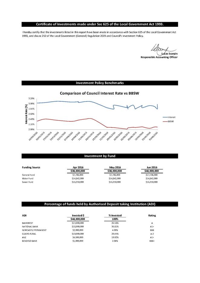
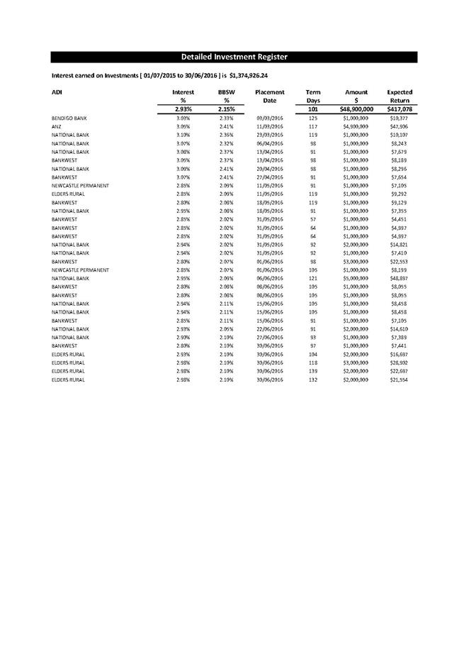
Delegates
Reports
20 July 2016
15.1 2016
National General Assembly of Local Government................................... 517
|
Council 20 July 2016
|
Item 15.1
|
15.1. 2016 National General Assembly of Local Government
Report
on the National General Assembly held in Canberra 19 – 22 June 2016
Cr Britten, Mayor
Pre
Conference Seminar - Supporting a Prosperous Visitor Economy
A seminar was held on Sunday 19
June 2016 entitled “Supporting a Prosperous Visitor Economy” and
was attended Cr Britten, Councillor Tapscott and Lucas Scarpin.
Various presentations were made around the “State of
the Region Report”, a copy of which is available at http://alga.asn.au/?ID=165 and a detailed statistical analysis
on Tourism produced by Tourism Research Australia. In summary:
The emphasis was on assessing across the Region:
resilience/wellbeing/liveability. The figures for the South Coast are from
south of Wollongong to the border. Possibly in the future we need to ask
for a separation to cover Eurobodalla Shire Council and ourselves for the
benefit of the MOU and in due course one covering the area proposed for the
joint organisation.
Other presentations were around the growth of the Visitor
economy and for Local Government to be an essential part of that growth. The
Regions need to be developed in balance with the cities and grow high level
technical skills to assist growth in the Region (technical skills includes all
professional skills)
Housing Affordability is stunted by wage income in the
Regions and to increase wealth you need to attract private investment in the
region and to do this you need to have the Public Sector providing the
framework and generally speaking this is not happening at present with the
failure to upgrade infrastructure across Australia.
The main Tourism Growth over last 10 years is in
International Tourism and this should increase with a devalued Australian
dollar and each area needs to establish its own competitive edge.
At present only 2% of Chinese Tourists visit Australia and
this is likely to increase substantially with the growth of a wealthy middle
class in most of Asia.
Tourism will continue to be a major growth industry in
Australia.
ALGA
National General Assembly
The Conference itself began on the Monday with a theme of
“Partners in an Innovative and Prosperous Australia”.
The main key note speaker was author journalist and
political commentator George Megalogenis who clearly outlined Australia’s
present position of failed infrastructure in not only providing catch up for
the existing population but needing to provide for a growth in population of
some 15 million in our major cities over the next 30 years. He highlighted that
the world has the lowest interest rates in 500 years (since the bubonic plague)
and Australia has the highest growth rate in population by percentage since the
gold rush days. Local Government in Australia has some $50 Billion in backlog
in infrastructure and receives a vastly disproportionate distribution of
taxation to cope with that backlog.
He emphasised that apart from the NSW Government other
Governments in Australia did not appear to be rising to the challenge of
providing infrastructure for the future and gave examples of State Elections
being lost in Victoria on 2 occasions where Government changed direction on
providing rail infrastructure as previously promised. He emphasised the need of
all levels of Government to relate to the needs of their areas.
Other speakers throughout the Conference emphasised the need
for smart cities and to innovate and collaborate rather than follow a rigid
hierarchy. Emphasis was made on the need to grow our infrastructure in Ports,
Airports, and cross continent train infrastructure to allow Australia to remain
competitive in provision of goods to the Regions and to the world.
The need to plan for technology growth and the associated
cyber risk by 2019 could cost the economy $2.1 Trillion.
The ATO presented on their new technology in relation to the
Australian Business Reporter, Standard Business Reporting and Electronic
Invoicing. A presentation was also made on the forthcoming Census and the new
approach moving towards high quality data as the information form the Census
dictates distribution of funding for the GST, education, housing etc. Our
Census covers 10 million households with 24 million people and we are .3 of 1%
of the world’s population. The Census can either be completed online this
year or in hardcopy.
There were several speakers on the provision of
infrastructure in Australia and in Boston USA giving examples of innovation and
making a point of difference for your area.
With much emphasis on the growth of cities, all levels of
Government need to create diversification for growth in the Regions.
As part of the Forum on the Tuesday, there were 3
concurrent sessions:
a)
Civic Technology to drive economic outcomes and community
The session focussed on lessons and models from the City of
Boston with presentations from four staff members looking at a range of
projects, programs and services covering new urban mechanics, DoIT (Department
of Information and Technology) and innovation spaces. Re-invention of spaces
and innovation have encouraged exciting new initiatives in some of the lower
socio-economic communities. Youth employment strategies and co-working spaces
as well as dynamic teams and agile support processes have been a key aspect of
developing a new approach to how the City operates in this area. Whilst
obviously the scale of projects and programs operated by the City of Boston are
much larger than Bega Valley the link to what is happening locally was very
obvious. The Bega Co-working space and local youth initiatives such as NetGen
and the Hackathon and Australia’s first Regional Innovation Week showed
that local thinking is well aligned to what large, overseas cities are
undertaking.
b)
The Infrastructure Challenge
2015 National State of the Assets Community
Infrastructure Report
Mr Steve Verity (Jeff Roorda and Associates) -
1. National
approach needed $47b value
2. Road
and buildings, W&S etc.
3. Asset
Management Plans are only recent
4. Social
equity not costed as built
5. We
have $41b to maintain $385b with $47b in poor condition State of Nation Assets
Review
6. Infrastructure
is high cost and risk
7. Improvement
is high benefit
8. Local
Government has the problem and needs a national assets management plan
9. Changes
need to relate freight infrastructure to technology and social infrastructure
to demographics and 3 way discussions with Governments
10. Population
grows at 400,000 per year and ongoing
11. Demographics
of ageing
12. Message
1 national plan
13. Message
2 annual reporting on opportunities
14. Message
3 strategic planning at lowest cost life cycle stop the disconnect
15. Message
4 key national assets will drive the agenda
16. Message
5 balance service level with risk from climate change etc.
17. Strategic
is modified by each areas demands
Road Network National Ausroads
Mr Peter Duncan, Chief Executive, Roads and Maritime
Services
1. 291b passengers in 2013/14 on 874,000
km
2. See Ausroads strategic plan 2016/2020
3. $10b per year needed in NSW and
greatest expenditure ever is happening
National Heavy Vehicle Regulator (NHVR)
Mr John Gilbert, OAM, Manager Industry Stakeholder
Engagement
1. 520,000heavy vehicles nationally in
Australia
2. Strategic plan for heavy vehicles
10years
3. Access connect program customer portal
for industry August release
4. Road manager portal by end of this
year Permits v pre- approved roads for heavy vehicles
5. This association can save time
6. Freight truck movement will double in
next 20 years
7. Benefit of PBS vehicles instead of B
doubles
c) Innovative
Approaches to the Environment
This session was conducted by Steve Bygrave, CEO of Beyond
Zero Emissions
Simon Richardson Mayor of the Byron Bay Council.
The discussion centred around zero emissions and transition
to renewable energy. The Paris agreement signed by 1000 mayors from
around the world was featured in the discussion.
It was noted that while zero emissions was preferable a lot
of councils were signed up to the 20/20 agreement. Byron Bay Shire has
ten year target for zero emission.
It was acknowledged that community needs to own and benefit
from the project. It was also advisable that councils current emissions
needed to be established as a base line.
I was of the opinion, after leaving the session, that Bega
Valley Shire in partnership with Clean Energy for Eternity Inc was well
in advance of some councils on this issue.
At different times the Minister for Local Government Paul
Fletcher, presented on the critical need for the NBN and technology and the
Shadow Minister Julie Collins presented on Labors commitment to Local
Government.
Conference
resolutions
As part of the Conference Bega Valley Shire Council
presented on two motions, previously accepted by the Council. The motion
in relation to coastal risk management was supported unanimously by the
Conference. The motion in relation to guidelines for prohibiting the use
of the release of balloons was narrowly defeated on the grounds that it was a
matter for State Governments to regulate.
Motion 40.1 Bega Valley
Shire Council NSW, Eurobodalla Shire Council NSW and East Gippsland Shire
Council VIC
That the National General
Assembly call on the Australian Government to develop an Intergovernmental
Agreement on the Coastal Zone in consultation with state, territory and local
governments as a means of defining the roles and responsibilities of each tier
of government in relation to coastal zone management.
Objective
The objective of the motion is
to promote a collaborative national approach to coastal zone management. The
coast is one of Australia's most highly valued and productive social, economic
and environmental assets, but there is a lack of consistency between the current
approaches to coastal policy and management adopted by the Australian, State,
Territory and local governments. An effective partnership between the three
levels of government, which clarifies their roles and responsibilities in
relation to coastal zone management, is required to ensure coastal Australia
can achieve a sustainable and prosperous future by withstanding the projected
impacts of climate change.
Arguments
The coastal zone is home to
Australia's state capitals, to most of the nation's commercial assets and to
more than 85% of Australia's population. It plays a pivotal role in the life of
the nation, however it is under increasing threat from a complex set of risks
including widespread coastal erosion, rising sea levels and more frequent and
severe extreme weather events. The publication 'Climate change risks to
Australia's coast: a first pass national assessment', released in 2009 by the
former Department of Climate Change, projected that approximately 247,000
existing residential properties in coastal areas, valued at up to $63 billion,
are at risk of inundation resulting from sea level rise of 1.1m. This is in
addition to assets such as roads, schools, hospitals, power stations and
commercial properties. As matters currently stand, coastal councils are at the
forefront of responding to these risks but are ill-equipped to respond
appropriately to the challenges involved. The vertical fiscal imbalance in the
Australian federation means that councils lack the funding required for
effective adaptation measures. They also lack appropriate policy guidance in
many jurisdictions. The enormous task of managing and caring for the nation's
36,000kms of coastline is beyond the capacity of local councils. There is an
urgent need for a collaborative national approach, based on an effective
partnership between the three levels of government, to work together to
implement the measures necessary to ensure the long-term sustainability and
prosperity of Australia's coastal zone and its communities.
As a matter of interest our Shire presented three
resolutions at last year’s conference and those resolutions and the
resulting action on them are attached.
By way of a final comment, George Megalogenis stated that
the failure in infrastructure in Australia also applied to the media and they
were reacting by being more vocal to remain relevant.
Attachments
1. Resolutions
of the 2015 National General Assembly of Local Government
|
Council
|
20 July 2016
|
|
Item 15.1 - Attachment 1
|
Resolutions of the 2015 National General Assembly of Local
Government
|
Questions On
Notice
20 July 2016
19.1 Changes
to Property Addresses within Bega Valley Shire................................ 524
19.2 Tura
Marrang Library and Community Centre................................................. 528
|
Council 20 July 2016
|
Item 19.1
|
19.1. Changes to Property Addresses within Bega Valley Shire
At
the Council meeting held on 29 June 2016, Cr Tapscott asked to be provided with
a report outlining Council’s role and process in regard to recent advice
to property owners regarding requirements to change the street numbering for
their properties.
General Manager
NSW
Address Program
Land and Property Information (LPI) NSW commenced an Address
Program in July 2015 with the aim of increasing the accuracy of both LPI and
local government data content throughout the sNSW. A complete
formal address is becoming increasingly important and improves the efficiency
and effectiveness of delivery for emergency services, postal services, goods
delivery, government and utility services in the area.
The LPI initiated program examined Council’s
addressing data in order to capture missing addresses, identify areas of low
addressing quality, improve the accuracy of the mapping coordinates associated
with an address and to maintain address data currency with many other
government agencies.
Once LPI had completed their initial examination of
addressing data throughout the Bega Valley LGA, a report was provided to
Council for review of this information. A recommendation was provided by
LPI for each of the properties identified with addressing issues and Council
officers were asked to assist LPI in implementing these changes. Over 500
properties with inconsistent or incorrect addressing which did not comply with
Australian Addressing Standards were identified within the Bega Valley.
Council officers reviewed each of the properties identified and either implemented
the change as suggested by LPI, found a more effective solution to the
addressing issue which would cause less inconvenience to the property owner, or
resolved to make no change to the address at all as the benefits achieved in
doing so were considered to be minimal.
The major causes of low addressing quality were as a
result of:
· Property owners using their Lot number, rather than a
rural address number (using the distance based number system), resulting in the
duplication of numbers within a road/street;
· Further subdivision within an area had meant the
original address given was no longer relevant, with the result being either
renumbering of properties or a complete change of road name;
· The partial formal closure of roads over time had resulted
in severed streets which could only be accessed from two different locations.
An extensive media campaign was conducted in February
this year advising residents throughout the Shire of the Addressing Program and
why the changes being requested were necessary. A letter of support from
the LPI was also issued to all NSW Councils which could be provided to any
property owners who were being asked to amend their property address details, a
copy of which is attached for the information of Councillors.
Attachments
1. Media
Release - Property Addressing Issues
2. LPI
Letter of Support for Councils
|
Council
|
20 July 2016
|
|
Item 19.1 - Attachment 1
|
Media Release - Property Addressing Issues
|
|
Council
|
20 July 2016
|
|
Item 19.1 - Attachment 2
|
LPI Letter of Support for Councils
|
|
Council 20
July 2016
|
Item 19.2
|
19.2. Tura Marrang
Library and Community Centre
At the Council meeting held on 18 May
2016, Cr Allen asked could Councillors receive a complete
financial reconciliation of the Tura Beach library project from purchase to
completion including an assessment of staff time involved in the project and
also including the business plan for the project.
The question
was taken on notice by the Director, Community Relations and Leisure Group
Director Community, Relations and Leisure
Response
In response to the Question on Notice a memo has been
distributed to all Councillors.
Attachments
Nil
Confidential Business
Adjournment Into Closed Session
In accordance with the Local Government Act 1993, and the
Local Government (General) Regulation 2005, in the opinion of the General
manager, the following business is of a kind as referred to in Section 10A(2)
of the Act, and should be dealt with in a Confidential Session of the Council
meeting closed to the press and public.
Recommendation
That Council adjourn into Closed Session and members of
the press and public be excluded from the meeting of the Closed Session, and
access to the correspondence and reports relating to the items considered
during the course of the Closed Session be withheld unless declassified by
separate resolution. This action is taken in accordance with Section 10A(2)
of the Local Government Act, 1993 as the items listed come within the
following provisions:
22.1 General Manager Annual Performance
Review for period ending 30 June 2016
Reason
for Confidentiality
This item is classified
CONFIDENTIAL under the provisions of Section 10A(2) of the Local Government
Act, which permits the meeting to be closed to the public for business
relating to (a) the report contains personnel matters concerning particular
individuals.
Reason
for Confidentiality
This item is classified CONFIDENTIAL
under the provisions of Section 10A(2) of the Local Government Act, which
permits the meeting to be closed to the public for business relating to (a)
the report contains personnel matters concerning particular individuals and
(c) the report contains information that would, if disclosed, confer a
commercial advantage on a person with whom the Council is conducting (or
proposes to conduct) business.
Reason
for Confidentiality
This item is classified
CONFIDENTIAL under the provisions of Section 10A(2) of the Local Government
Act, which permits the meeting to be closed to the public for business
relating to (a) the report contains personnel matters concerning particular
individuals and (c) the report contains information that would, if disclosed,
confer a commercial advantage on a person with whom the Council is conducting
(or proposes to conduct) business.
|