|

Ordinary
Meeting Notice and Agenda
An Ordinary Meeting of the Bega Valley Shire Council will be held at Council Chambers, Bega on Wednesday, 14 October 2015 commencing at 2.00
pm to consider and resolve on the matters set out in
the attached Agenda.
8
October 2015
|
TO:
Cr Michael Britten, Mayor
Cr Liz Seckold, Deputy Mayor
Cr Tony Allen
Cr Russell Fitzpatrick
Cr Keith Hughes
Cr Ann Mawhinney
Cr Kristy McBain
Cr Sharon Tapscott
Cr Bill Taylor
|
COPY:
General Manager, Ms Leanne Barnes
Group Manager Transport and Utilities, Mr Wayne
Sartori
Group Manager Planning and
Environment, Mr Andrew Woodley
Group Manager Community Relations
and Leisure, Mr Anthony Basford
Group Manager Strategy and
Business Services, Mr Lucas Scarpin
Executive Manager Organisational
Development and Governance, Ms Nina Churchward
Minute Secretary
|
|
Publishing Of Agendas And Minutes
The Agendas for Council Meetings
and Council Reports for each meeting are available from 5.00 pm one week prior
to each Ordinary Meeting, on Council’s website. A hard copy is also
made available to each Library Branch and at the Bega Administration Building
reception desk.
The Minutes of Committee and Council
Meetings are available from 5.00pm on Council's Web Site on the Friday after
the Meeting on Councils website and hard copies distributed with the Agenda for
the following meeting.
1. Please
be aware that the recommendations in the Council Meeting Agenda are
recommendations to the Council for consideration. They are not the
resolutions (decisions) of Council.
2. Background
for reports is provided by staff to the General Manager for presentation
to Council.
3. The
Council may adopt these recommendations, amend the recommendations, determine a
completely different course of action, or it may decline to pursue any course
of action.
4. The
decision of the Council becomes the resolution of the Council, and is recorded
in the Minutes of that meeting.
5. The
Minutes of each Council meeting are published in draft format, and are
confirmed, with amendments by Councillors if necessary, at the next available
Council Meeting.
If you require any further information
or clarification regarding a report to Counci, please contact Council’s
Executive Assistant who can provide you with the appropriate contact details
Phone
(6499 2104) or email execassist@begavalley.nsw.gov.au.
Ethical Decision Making and Conflicts of
Interest
A guiding checklist for Councillors, officers and community committees
Ethical decision making
·
Is the decision or conduct legal?
·
Is it consistent with Government policy, Council’s
objectives and Code of Conduct?
·
What will the outcome be for you, your colleagues, the Council,
anyone else?
·
Does it raise a conflict of interest?
·
Do you stand to gain personally at public expense?
·
Can the decision be justified in terms of public interest?
·
Would it withstand public scrutiny?
Conflict of interest
A conflict of interest is a clash between private interest
and public duty. There are two types of conflict:
·
Pecuniary
– regulated by the Local Government Act and Department of Local
Government
·
Non-pecuniary
– regulated by Codes of Conduct and policy. ICAC,
Ombudsman, Office of Local Government (advice only). If declaring a
Non-Pecuniary Conflict of Interest, Councillors can choose to either disclose
and vote, disclose and not vote or leave the Chamber.
The test for conflict of
interest
·
Is it likely I could be influenced by personal interest in
carrying out my public duty?
·
Would a fair and reasonable person believe I could be so
influenced?
·
Conflict of interest is closely tied to the layperson’s
definition of ‘corruption’ – using public office for private
gain.
·
Important to consider public perceptions of whether you have a
conflict of interest.
Identifying problems
1st Do
I have private interests affected by a matter I am officially involved in?
2nd Is
my official role one of influence or perceived influence over the matter?
3rd Do
my private interests conflict with my official role?
Whilst seeking advice is generally useful, the ultimate
decision rests with the person concerned.
Agency advice
Officers of the following agencies are available during
office hours to discuss the obligations placed on Councillors, officers and
community committee members by various pieces of legislation, regulation and
codes.
|
Contact
|
Phone
|
Email
|
Website
|
|
Bega
Valley Shire Council
|
(02)
6499 2222
|
council@begavalley.nsw.gov.au
|
www.begavalley.nsw.gov.au
|
|
ICAC
|
8281
5999
Toll
Free 1800 463 909
|
icac@icac.nsw.gov.au
|
www.icac.nsw.gov.au
|
|
Office
of Local Government
|
(02)
4428 4100
|
olg@olg.nsw.gov.au
|
http://www.olg.nsw.gov.au/
|
|
NSW
Ombudsman
|
(02)
8286 1000
Toll
Free 1800 451 524
|
nswombo@ombo.nsw.gov.au
|
www.ombo.nsw.gov.au
|
TO: The
General Manager
Bega Valley Shire Council
Disclosure of pecuniary interests / non-pecuniary conflict of interests
In accordance with the
Council’s Code of Meeting Practice and the requirements of the Local
Government Act and regulations or dispensation issued by the Office
of Local Government I hereby disclose the following pecuniary interests
and/or non-pecuniary conflict of interests at the meeting as indicated below:
Ordinary meeting held on _____ / _____ / 20___
dd mm yy
|
Item no
& subject
|
|
|
Interest (tick one)
|
Pecuniary
interest Non-pecuniary
conflict of interest
|
|
* Nature of
interest
|
|
|
If
Non-pecuniary (tick
one)
|
Disclose
& vote Disclose
& not vote Leave
chamber
|
|
|
|
|
|
|
|
Item no
& subject
|
|
|
Interest (tick one)
|
Pecuniary
interest Non-pecuniary
conflict of interest
|
|
* Nature of
interest
|
|
|
If
Non-pecuniary (tick
one)
|
Disclose
& vote Disclose
& not vote Leave
chamber
|
|
|
|
|
|
|
|
Signed
|
|
|
Print Name
|
Councillor
|
* Note: Under the provisions of Section
451(1) of the Local Government Act 1993 (pecuniary interests) and Part
6.11 of the Model Code of Conduct prescribed by the Local Government
(Discipline) Regulation 2004 (conflict of interests) it is necessary for you to
disclose the nature of the interest when making a disclosure of a pecuniary
interest or a non-pecuniary conflict of interest at a meeting.
Agenda
Acknowledgement of Traditional Owners of Bega Valley Shire
I would like to commence by
acknowledging, on behalf of Bega Valley Shire Council the Traditional
Custodians of the lands and waters of the Shire – the people of Yuin
nation and show our respect to elders past and present.
1 Apologies and requests for leave of
absence
2 Confirmation Of Minutes
Recommendation
That the Minutes of the Ordinary Meeting held on 23
September 2015 as circulated, be taken as read and confirmed.
3 Declarations
Pecuniary,
Non-Pecuniary and Political Donation Disclosures to be declared and tabled.
4 Deputations (by prior arrangement)
4.1 Denis
Lea and Anthony Taylor - DA 2013.0373 Lot 2 DP 582074 Thompson Drive Tathra. Report
No 8.1 33 lot subdivision - Tathra River Estate, Thompson Drive Tathra................................................... 9
5 Petitions
6 Mayoral Minutes
7 Adjournment to Standing Committees
Recommendation
That the Ordinary meeting of the
Council be adjourned for the purpose of dealing with staff reports to Standing
Committees.
8 Staff Reports – Planning and
Environment (Sustainability)
In accordance with Council’s Code of Meeting
Practice, this section of the agenda will be chaired by Cr Taylor.
8.1
33 lot subdivision - Tathra River Estate, Thompson Drive Tathra.......................................... 11
8.2 Regularisation
of unauthorised additions to attached dual occupancy, 2 Coraki Drive, Pambula
Beach 62
8.3 Section
96 application to modify condition 5 - Alterations and additions to
entertainment establishment - Four Winds Barraga Bay................................................................................................................ 74
8.4 Companion
Animals Control Procedure..................................................................................... 78
8.5 Construction
of self storage units - Old Wallagoot Road, Kalaru............................................ 87
8.6 Draft
Voluntary Planning Agreement Variation Deed - Service Road, Merimbula............ 111
8.7 Establishment
of Weekly Markets for up to 40 stallholders - Littleton Gardens, Bega.... 113
9 Staff Reports – Community,
Culture and Leisure (Liveability)
In accordance with Council’s Code of Meeting Practice
, this section of the agenda will be chaired by Cr Tapscott.
9.1 NSW
Public Libraries Conference 2015................................................................................... 126
9.2 RFT59/15
Construction of Timber Footbridges and Gravel Pathways, Lake Curalo, Eden 128
9.3 RFT
64/15 - Conversion of building to library facility at Tura Beach................................... 131
10 Staff Reports
–Economic Development and Business Growth (Enterprising)
In accordance with Council’s Code of Meeting
Practice, this section of the agenda will be chaired by Cr McBain.
Nil Reports
11 Staff Reports – Infrastructure Waste and
Water (Accessibility)
In accordance with Council’s Code of Meeting
Practice, this section of the agenda will be chaired by Cr Fitzpatrick.
11.1 Formalisation
of road name: Virginia Drive, Bega ............................................................... 138
11.2 Formalisation
of road name: Robin Close, Merimbula........................................................... 141
11.3 Off-road
bike path options for Tathra to Kalaru and Kalaru to Bega................................... 144
11.4 Request
by Bermagui Mens Shed for long term lease of old Bermagui landfill site......... 146
11.5 Water
Trunk Mains Cleaning Services ..................................................................................... 150
12 Staff Reports –
Governance and Strategy (Leading Organisation)
In accordance with Council’s Code of Meeting
Practice, this section of the agenda will be chaired by Cr Mawhinney
12.1 Major
projects quarterly update............................................................................................... 154
12.2 Actions
from resolutions of Council - Status Report.............................................................. 157
12.3 Internal
Audit Committee Yearly Review 2014/15.............................................................. 189 .
13 Staff Reports – Finance (Leading
Organisation)
In accordance with Council’s Code of Meeting
Practice, this section of the agenda will be chaired by Cr Hughes
13.1 Local
Government Grants Commission - financial assistance grants 2015-16................... 205
13.2 Certificate
of Investments made under Section 625 of the Local Government Act, 1993 239.
14 Adoption of Reports from Standing Committees
Recommendation
That all motions recorded in the
Standing Committees, including votes for and against, and acknowledging
declarations of interest already made, be adopted in by the Ordinary Council
meeting.
15 Delegates Reports
15.1 Cr
Britten: 2015 LGNSW Water Management Conference ................................................ 244
16 Rescission/alteration Motions
17 Notices of Motion
18 Urgent Business
19 Questions On Notice
19.1 Off-road
bike path options for Tathra to Kalaru and Kalaru to Bega .................................. 246
20 Questions for the Next Meeting
21 Items of Interest Relating to Council Business
22 Confidential Business
23 Adoption of reports from Closed Session
24 Resolutions to declassify reports considered in
closed session
Deputations
(by prior arrangement)
14 October 2015
4.1 Denis
Lea and Anthony Taylor - DA 2013.0373 Lot 2 DP 582074 Thompson Drive Tathra.
Report No 8.1 33 lot subdivision - Tathra River Estate, Thompson Drive Tathra............. 9
|
Council 14 October 2015
|
Item 4.1
|
4.1. Denis Lea and Anthony
Taylor - DA 2013.0373 Lot 2 DP 582074 Thompson Drive Tathra. Report
No 8.1 33 lot subdivision - Tathra River Estate, Thompson Drive Tathra
Mr Denis Lea and Mr Anthony Taylor have requested to
address Council
General Manager
As per Council’s Code of Meeting Practice requests received
up to eight days prior to a meeting will be listed in the Agenda for that
meeting.
Mr Tayor will address the meeting and has been advised on
the process as outlined in the Code of Meeting Practice.
Attachments
Nil
Staff Reports –Planning And Environment (Sustainability)
14 October 2015
In accordance with Council’s Code of Meeting
Practice (2011), this section of the agenda will be chaired by Cr Taylor.
8.1
33 lot subdivision - Tathra River Estate, Thompson Drive Tathra..................... 11
8.2 Regularisation
of unauthorised additions to attached dual occupancy, 2 Coraki Drive, Pambula
Beach................................................................................................................... 62
8.3 Section
96 application to modify condition 5 - Alterations and additions to
entertainment establishment - Four Winds Barraga Bay........................................................... 74
8.4 Companion
Animals Control Procedure.............................................................. 78
8.5 Construction
of self storage units - Old Wallagoot Road, Kalaru....................... 87
8.6 Draft
Voluntary Planning Agreement Variation Deed - Service Road, Merimbula....... 111
8.7 Establishment
of Weekly Markets for up to 40 stallholders - Littleton Gardens, Bega 113
|
Council 14 October 2015
|
Item 8.1
|
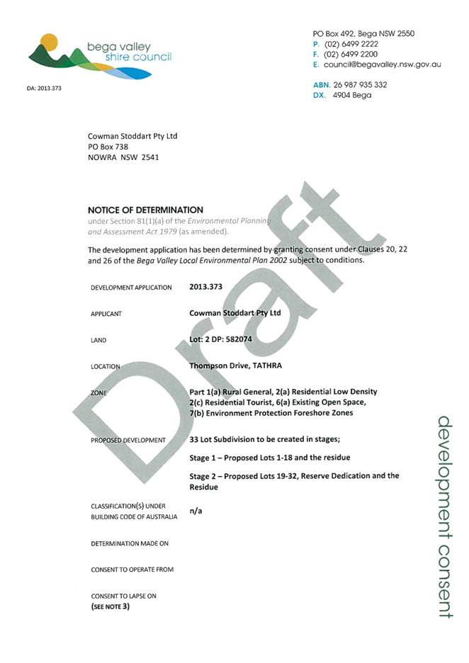
8.1. DA No.
2013.373: 33 lot subdivision - Tathra River Estate, Thompson Drive Tathra
Group Manager Planning and Environment
|
Applicant
|
Cowman Stoddart Pty Ltd
|
|
Owner
|
Linkwood Nowra Pty Ltd
|
|
Site
|
Lot 2 DP 582074,
Thompson Drive, Tathra
|
|
Zone
|
Part 2(a) Low Density
Residential, 2(c) Residential Tourist, 1(a) Rural General, 7(b) Environment
Protection Foreshore, 6(a) Existing Open Space under BVLEP 2002
|
|
Site area
|
130ha
|
|
Proposed
development
|
33 Lot Subdivision
|
Precis
Council is
in receipt of an application to subdivide Lot 2 DP 582074 into 32 rural
residential style allotments, a public reserve and a residue lot.
The land is
the subject of a masterplan approved in 2013 by the then Department of Planning
and Infrastructure, now the Department of Planning and Environment (the
Department) and is a deferred matter under Bega Valley Local Environmental Plan
2013 (BVLEP 2013).
A total of
22 submissions were received from 16 individuals during the public exhibition
period.
The
application is reported to Council for determination on the basis of the
broader public interest considerations for the land.
The DA is
recommended for approval, subject to conditions.
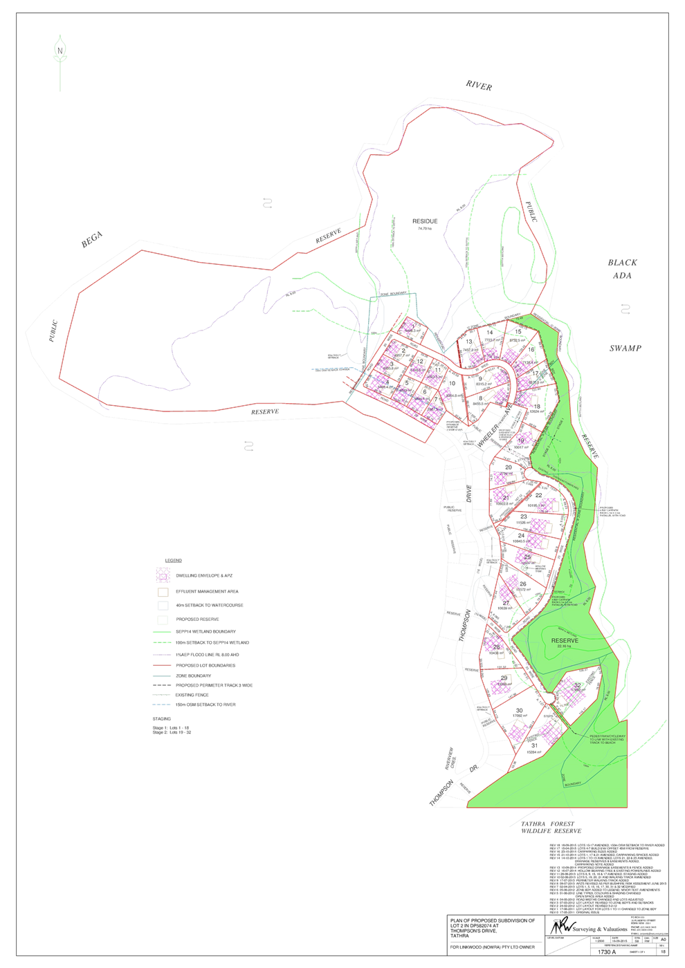
Description of the proposal
The proposal
consists of the subdivision of Lot 2 DP 582074 into 32 allotments, varying in
size from 3,987.3m2 to 17,692m2 with a proposed reserve
dedication of 22.16 hectares and a residue allotment of 74.70 hectares.
The proposed
subdivision would be constructed in two parts, with the first stage comprising
Lots 1-18 and the second stage comprising Lots 19-32 plus the residue lot and
reserve dedication.
It is
proposed all access to the subdivision will be provided via Thompson Drive from
Tathra Road. Internal access will be via a number of new roads off Thompson
Drive and Wheeler Avenue.
The
Subdivision Plan is provided as Attachment 1 to this report.
Description of the site
The site
comprises a total of 130 hectares located on a peninsula between the Bega River
Estuary and Blacka Ada Swamp. The land adjoins 63 residential allotments that
were previously developed along Thompson Drive and is known locally as Tathra
River Estate.
The land
that is the subject of this DA is located to the north and east of the existing
residential development.
The land is
dominated by an elevated ridge crest visible from surrounding areas, the Bega
River and the coast. The topography generally slopes to the Bega River and
adjoining coastal wetlands (identified under SEPP14 – Coastal Wetlands).
It is a sensitive coastal location as identified by SEPP 71.
The site has
been extensively cleared with a long history of grazing.
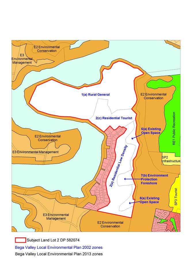
A Locality
and Zoning Map is provided as Attachment 2 to this report.
Planning assessment
The proposal
has been assessed in accordance with the Matters for Consideration under
Section 79C of the Environmental Planning and Assessment Act 1979.
Council staff has highlighted the key issues of the proposal in this report for
Council’s consideration.
A copy of
the assessing officer’s Section 79C assessment will be available at the
Council meeting.
Zoning
The site is a
deferred matter under Bega Valley Local Environment Plan 2013 (BVLEP 2013) with
the provisions of Bega Valley Local Environmental Plan 2002 (BVLEP 2002)
applying.
A Planning
Proposal, prepared in accordance with the Council resolution for zoning of the
land, is currently with the Department for consideration. The Planning Proposal
aims to zone the land R5 Large Lot Residential Zone with a minimum lot size of
5,000m2, with the exception of the river flats which are proposed to
be zoned RE1 Public Recreation and an E2 Environmental Conservation Zone around
the Bega River foreshore and wetland areas.
The
subdivision layout would be consistent with the proposed zonings, however the
lot size would need to be amended should this application be approved.
The site
currently comprises a mix of zones under BVLEP 2002, including:
1(a) Rural
General;
2(a) Residential
Low Density;
2(c) Residential
Tourist;
6(a) Existing
Open Space; and
7(b) Environmental
Protection Foreshore.
Attachment 2
to this report provides a zoning map extract indicating the current BVLEP 2002
zones applying to the subject site and the adjoining zones which are zoned
under the provisions of BVLEP 2013.
The
allotments are located within those areas of the site currently zoned 2(a)
Residential Low Density and 2(c) Residential Tourist.
The
objectives of the 2(a) zone are as follows;
(a) To
allow residential development, including dwelling houses and attached dual
occupancies
(b) To
maintain and enhance the character of residential areas, to promote good design
(c) To
enable development which services the needs of people in the residential areas
(d) To
ensure that development does not have an unacceptable impact on adjoining land,
by way of shadowing, invasion of privacy, noise and the like.
The
objectives of the 2(c) zone are as follows:
(a) To
provide for a variety of development opportunities intended to accommodate
tourists, visitors and residents alike, and
(b) To
ensure that the scale and function of tourist development is appropriate in the
context of the form of development which might otherwise occur in the zone
(c) To
ensure that tourist development does not significantly adversely impact on the
amenity of the residential areas in adjacent zones and is of a scale
appropriate to the need for that development.
The
proposal, as assessed, is considered to be consistent with the objectives of
the 2(a) and 2(c) zones, for the reasons highlighted in this report and the
Section 79C Report.
Strategic
context
State
Environment Planning Policy (SEPP 71) masterplan
The subject
land is located in the NSW Coastal Zone and as such triggered the requirements
for the preparation of a masterplan under the provisions of the SEPP 71
(Coastal Protection).
A masterplan
is required for “subdivision of land within a residential zone, or a
rural residential zone, if part or all of the land is in a sensitive coastal
location, or subdivision of land within a residential zone (that is not
identified as a sensitive coastal location) into more than 25 lots, or 25 lots
or less (if the land proposed to be subdivided and any adjoining or
neighbouring land in the same ownership could be subdivided into more than 25
lots)”.
The approved
masterplan sets out, in broad terms, a scheme or framework to guide future
plans and is in itself not a statutory or legal document.
This site
was also considered in the South Coast Sensitive Urban Lands Review, 2006 (The
Review) prepared by an independent Panel chaired by Andrew Refshauge. The
Review identified a number of site constraints and a significantly higher yield
based on connection to the existing Tathra sewage treatment plant, a concept
which has since been found to be unviable. The issues raised by The Review were
addressed in the approved Masterplan.
The
development application now before Council is considered to be generally
consistent with the approved masterplan in terms of the allotment design,
achieving suitable buffers to environmentally sensitive areas, ensuring the
protection of Aboriginal archaeology, improving access to foreshore areas,
providing suitable effluent management and stormwater controls.
Issues
The
assessment of the application has identified several key issues which are
discussed in detail below.
Environmental
impacts
Flora and fauna
The subject
site has been predominantly cleared and grazed as pasture lands for many years
and exotic pasture with scattered remnant trees is the predominant community.
The majority of the impact would be on Coastal Gully Shrub Forest which is not
an over cleared vegetation type or an Endangered Ecological Community (EEC).
There are
some areas of the site that continue to support native vegetation, and there
are also three EECs on the site which include Lowland Grassy Woodland, Swamp
Sclerophyll Forest and Coastal Saltmarsh. The proposal has been designed so as
to avoid any direct impacts on such and the impact on EECs is expected to be
negligible.
Fauna
habitats are typically associated with grazing lands and remnant forests
fringing estuarine habitats. The site supports a number of hollow bearing trees
and a variety of water habitats including relatively undisturbed estuarine
habitats.
The wetlands
within and surrounding the site and adjoining grassy habitats, provide
potential habitat for the Green and Golden Bell Frog. The Flora and Fauna
Assessment conducted by Ecological Australia reported no evidence of the
species was detected during the survey period, despite considerable targeted
surveys.
No
threatened fauna species were recorded on the subject land during the survey
period and the report concluded the site is not generally expected to provide
any critical habitat resources for any fauna species of conservation
significance.
Council’s
Environmental Services staff has assessed the application and identified there
is potential for micro bat usage within the identified hollow bearing tree on
proposed Lot 25. The applicant was requested to identify the subject tree on
the subdivision plan to ensure it is located outside of the building and
effluent disposal envelope. A restriction-as-to-user is recommended to be
placed on Lot 25 to ensure adequate protection of this tree.
Staff have
also identified there is potential for the saltmarsh to the north of the study
area to be used as a nesting area for White-fronted Chats. The amended road
layout in this northern part of the subdivision has resulted in allotments
being located further away from the identified area of Coastal Saltmarsh and
therefore this area would remain as part of the residue lot and would not be
impacted upon by subdivision construction activities.
Buffers to sensitive
environmental areas and connectivity
The proposed
subdivision design has evolved over the course of the Department’s
consideration of the masterplan and during the development application
assessment process. As a result, an allotment design and configuration has been
achieved that provides suitable buffers to the identified environmentally
sensitive areas, particularly the SEPP 14 wetlands to the east of the
subdivision and the adjoining Crown land to the south. This maintains
connectivity and enhances buffers to those sensitive environmental areas.
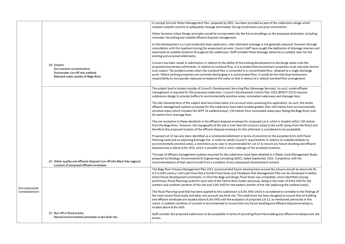
Effluent management
The subject
land is located outside of Council’s Development Servicing Plan (Sewerage
Services). As such, onsite effluent management is required for the proposed
subdivision. Council’s Development Control Plan 2013 (BVDCP 2013)
requires subdivision design to provide buffers to environmentally sensitive
areas, nominated waterways and drainage lines.
The site characteristics
of the subject land have been taken into account when assessing this
application. As such, the onsite effluent management systems proposed for the
subdivision have been located greater than 100 metres from environmentally
sensitive areas (which includes the SEPP 14 wetland areas), 150 metres from
nominated waterways (being the Bega River) and 40 metres from drainage lines.
The one
exception to these standards is the effluent disposal envelope for proposed Lot
4, which is located within 150 metres from the Bega River. However, the
topography of the site is such that the contours slope to the north (away from
the River) and therefore the proposed location of the effluent disposal
envelope for this allotment is considered to be acceptable.
Proposed Lot
13 has also been identified as a constrained allotment in terms of proximity to
the accepted 8.0m AHD Flood Planning Level and an adjoining drainage line. In
order to satisfy Council’s requirements in relation to suitable setbacks
to environmentally sensitive areas, a restriction-as-to-user is recommended for
Lot 13 to ensure any future dwelling and effluent disposal area is above 8.0m
AHD, which is possible with a minor redesign of the envelope locations.
The type of
effluent management systems required for the subdivision have been detailed in
a Water Cycle Management Study, prepared by Strategic Environmental and
Engineering Consulting (SEEC), dated September 2013. Council staff concur with
the recommendations of the SEEC report and compliance with those
recommendations would form a condition of any subsequent development
consent.
Traffic
generation and impact on road network
Tathra Road/Thompson Drive
intersection
The
intersection of Tathra Road and Thompson Drive has been the subject of a Traffic
Impact Assessment, prepared by ARC Traffic and Transport, dated February 2012
and a Review of Traffic Issues also prepared by ARC Traffic and Transport,
dated September 2013.
It has been
concluded that an upgrade of that intersection treatment is required, as a
result of the proposed subdivision. The NSW Roads and Maritime Services (NSW
RMS) have assessed the proposal and details of the required intersection
upgrade are provided later in this report, under Consultation.
Thompson Drive construction
In relation
to the adequacy of the existing Thompson Drive formation, Council's Design,
Development and Traffic Coordinator has assessed the proposal and is satisfied
with the existing formation and standard of the section of Thompson Drive
between Tathra Road and Riverview Crescent.
Traffic calming measures
It is
acknowledged the speed environment from Riverview Crescent north throughout the
existing estate needs to be addressed. Although this area is a signposted
50km/h precinct, concerns raised in submissions report that vehicle speeds are
often in excess of the signposted speed. This issue has previously been raised
with the Local Traffic Committee and has been brought to the attention of local
police through that Committee.
It is
considered appropriate, with the increase in daily traffic movements likely to
be generated by the development, that suitable traffic calming measures be
incorporated into the road network. As such, Council staff recommends the
following measures be included in any development consent issued in relation to
the subdivision:
· Construction of a sealed
type BAL intersection treatment at both junctions of Thompson Drive and
Riverview Crescent (that is, north and south);
· Creation of ‘choke
points’ at the existing concrete access driveways of Lots 8 and 38, 12
and 35, 18 and 30 in DP 261473;
· Construction of a sealed
type BAL intersection treatment at the junction of Thompson Drive with Wheeler
Avenue;
· Creation of ‘choke
points’ within Wheeler Avenue at the existing concrete access driveways
of Lots 25 and 26 in DP 261473.
Attachment
3 to this report illustrates the proposed locations for the road treatments
recommended by assessing staff.
Bus route
Currently,
the school bus route within Tathra River Estate circuits around ‘the
island’ of Riverview Crescent and Thompson Drive. As a result of the
proposed subdivision and the extension of Wheeler Avenue (which would be
required to be constructed to a bus route standard) the school bus route would
be able to be extended to service the length of Thompson Drive, making the
estate more accessible for public transport.
Hazards
and site constraints
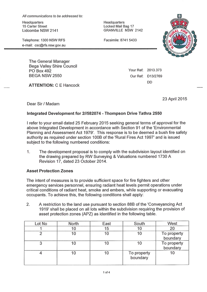
Bushfire
The subject
site is classified as Bushfire Prone Land for the purpose of the Rural Fires
Act 1997 and therefore the proposed development constitutes Integrated
Development, as a Bushfire Safety Authority is required from the NSW Rural Fire
Service (NSW RFS).
The proposed
subdivision has been designed in accordance with the provisions of Planning for
Bushfire Protection Guidelines and satisfies the NSW RFS requirements. As such,
NSW RFS have issued their General Terms of Approval in relation to the
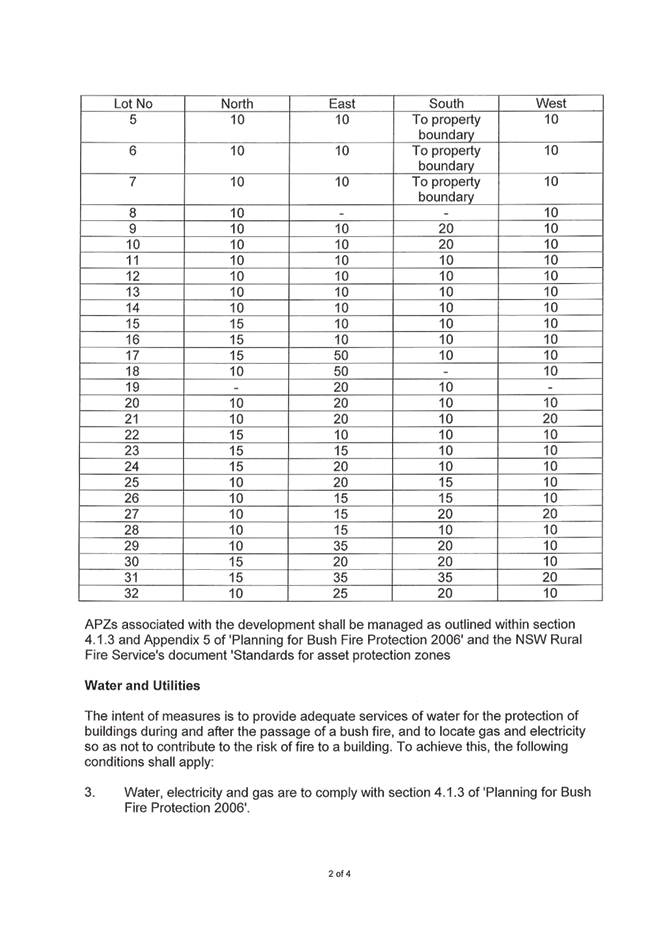
subdivision, subject to conditions relating to the provision of suitable Asset
Protection Zones (APZ’s) with a restriction required to be placed on the
title of each allotment specifying the required APZ’s, the suitable
provision and location of water (in this case rainwater harvesting with
suitable pumps and fittings), gas and electricity supplies and ensuring public
road access complies with the Planning for Bushfire Protection Guidelines, in
terms of width, turning radii, grades and crossfalls.
Additional
clarification was also sought from NSW RFS in relation to one of the specific
concerns raised in submissions, that being whether an Emergency Evacuation Plan
was required for the subdivision.
The
Department noted that this issue was raised in public submissions during the
masterplan process and recommended at that time that it would be appropriate
for Council to consider other matters in a bushfire emergency strategy such as
evacuation on-site, at the Development Application stage.
NSW RFS have
responded by advising the following;
“Section 4.1.3 of Planning for
Bushfire Protection 2006 nominates the standards for subdivision. Emergency
evacuation planning is not a standard identified in this planning control and
is not required as part of the assessment process for a Bush Fire Safety
Authority. Unless a subdivision was a community title subdivision I am not sure
how a subdivision specific emergency plan could be applied to each lot. The
specific standards for subdivision are Asset Protection Zones, Public Roads,
Property Access, Fire Trails, and Services – water, electricity and
gas”.
From the NSW
RFS perspective, the subdivision design adequately meets the Planning for
Bushfire Guidelines and an Emergency Evacuation Plan is not required for this
subdivision, and therefore has issued their General Terms of Approval.
The NSW RFS
General Terms of Approval would form an appendix to any development consent
issued in relation to the subdivision.
Flooding and Sea Level Rise
The Bega
River Estuary Management Plan 2011 recommended future development around the
estuary should be above the RL 4.0 m AHD contour until such time that a formal
Flood Study and Floodplain Risk Management Plan can be developed to better
direct future development constraints. In 2014 the Bega and Brogo Flood Study
was completed, which identified varying preliminary Flood Planning Levels for each
side of the Tathra River Estate peninsula, being in the order of 8.0m AHD for
the western and southern portions of the site and 5.0m AHD for the eastern
portion of the site (adjoining the wetland areas).
The Flood
Planning Level that has been applied to this subdivision is 8.0m AHD which is
considered to correlate to the findings of the most recent flood study. The
subdivision has been designed to ensure all building and effluent envelopes are
located above 8.0m AHD with the exception of proposed Lot 13, as mentioned
previously in this report. A suitable condition of consent is recommended to
ensure any future dwelling and effluent disposal envelope is located above 8.0m
AHD.
Council
staff consider that the proposed subdivision to be acceptable in terms of
providing flood free building and effluent envelopes and site access.
Contamination
A
preliminary contamination assessment was conducted for the site for the purpose
of the provisions of State Environmental Planning Policy No. 55 (Remediation of
Land) due to the history of the land being used for agricultural purposes. The
Contamination Assessment concluded the investigation revealed very little
evidence to suggest that Lot 2 DP 582074 could be potentially contaminated and
further investigations were not recommended. It was noted that minor herbicide
contamination could exist in the surface soils around the site however such
contamination is unlikely to persist beyond one (or at maximum two) growing
seasons.
Council
staff considers that the proposed use of the land for the purpose of
residential accommodation is suitable and remediation of the land is not
required.
Acid sulphate soils
The
potential for acid sulphate soils exists within the low lying swamps on the
eastern periphery of the subject site and in the low lying banks of the Bega
River. No works are proposed in these areas of the site and the subdivision
design would not impact on those areas. Therefore it is concluded that, for the
purpose of Clause 6.1 of the Bega Valley Local Environmental Plan 2013, an Acid
Sulphate Management Plan is not required for the proposed development.
Stormwater management
A concept
Soil and Water Management Plan, prepared by SEEC, has been provided as part of
the subdivision design which contains suitable controls to adequately manage
stormwater during construction and post-construction.
Water
Sensitive Urban Design principles would be incorporated into the future
dwellings on the proposed allotments, including rainwater harvesting and
suitable effluent disposal management.
As this
development is a rural residential style subdivision, inter-allotment drainage
is not generally required. However through consultation with the Applicant
during the assessment process, Council staff has sought the dedication of
drainage reserves and easements at suitable locations throughout the
subdivision. Council staff considers these drainage networks to suitably cater
for the existing and proposed allotments.
Concern has
been raised in submissions in relation to the ability of the existing
development to discharge water on to the proposed downstream allotments. In
relation to overland flow, it is accepted that downstream properties must
naturally receive such waters. The problem arises when the overland flow is
converted to a concentrated flow, released to a single discharge point. Where
existing properties are currently discharging in a concentrated flow, it would
be the individual landowner's responsibility to incorporate measures to
disperse the water so that it returns to a natural overland flow arrangement.
Visual
impact
The NSW
Coastal Design Guidelines recognise Tathra as a ‘coastal village’
and outlines issues and opportunities to be considered for any new developments
in such settlements, including the need to ensure new development is integrated
with the natural features of a site, respects the distinctive natural features
of coastal villages and ensures an appropriate scale in new development.
It is
recognised whilst the site is visually prominent from the Bega River, its
separation distance from the main road and the intervening bushland to the
township of Tathra limits the sites exposure from existing settlement areas.
However, it is considered appropriate that building height controls be reviewed
for this site, so to provide a suitable built form particularly when
considering the view to the site from Mogareeka.
Clause 85 of
BVLEP 2002 currently permits building heights up to 10 metres or 3 storeys.
Council has adopted reduced building heights in visually prominent locations
along our coastline, including at Pambula Beach, Merimbula and parts of Tathra
where a 7.5 metre Height of Buildings limitation has been incorporated under
BVLEP 2013.
Pending
resolution of the zoning and site controls under the current Planning Proposal,
it is considered a reasonable interim measure for Council to impose a 7.5 metre
height limitation for this subdivision, to ensure future development sits
comfortably within the landscape. A suitable condition of consent is
recommended in this regard.
It is
considered the NSW Coastal Design Guidelines and Council's Development Control
Plan 2013 provide suitable desired future character statements to guide future
dwelling design on the proposed allotments.
Public
access to foreshore areas
In its
comments to the Department regarding the draft masterplan, Council officers
suggested that the provision of a carpark at the northern end of Thompson Drive
would be advantageous to support increased pedestrian access to areas of
foreshore reserve. The masterplan was amended to include two carparking areas,
one being at the northern end of Thompson Drive and the other adjacent to
Blacka Ada Swamp.
The
subdivision plan currently before Council proposes the provision of two
carparking areas adjacent to Black Ada Swamp. No carpark is proposed at the
northern end of Thompson Drive as this subdivision does not propose public
access to the Bega River flats.
Having
considered the final subdivision layout currently before Council, staff is of
the opinion the proposed two carparking areas nominated to be provided adjacent
to the Black Ada Swamp reserve is adequate for this stage of the
subdivision.
It is
considered access to the Bega River foreshore area to the west would best be
serviced in any future subdivision, once the zoning and land use of the residue
allotment is resolved, including Council's consideration of any area to be
zoned RE1 Public Recreation and its intended servicing of that area.
Consultation
Input from
various state government agencies was sought to help inform the assessment
process. The following provides a summary of the key agencies feedback and
approvals.
NSW Rural Fire Service
As mentioned
previously in this report, the proposed subdivision has been designed in
accordance with the provisions of Planning for Bushfire Protection Guidelines
and satisfies the NSW RFS requirements.
As such, the
NSW RFS have issued their General Terms of Approval in relation to the
subdivision.
NSW Roads and Maritime
Service
The proposed
development was referred to the NSW RMS for assessment and comment, as a
traffic generating development. The application is supported by a Traffic
Report prepared by ARC Traffic and Transport and recommends treatments for the
intersection of Tathra Road and Thompson Drive.
The NSW RMS
have advised they concur with the recommendations of the Traffic Report and as
such the intersection junction would need to be upgraded to a sealed Type AUL
(S) (auxiliary left short) left turn in accordance with the Austroads Guide to
Road Design (this would provide a deceleration lane when traveling from Bega).
In addition, utilising the existing pavement, a linemarking adjustment would be
required to create a modified Type CHR (S) (channelised right short) right turn
configuration (this would provide a similar configuration for the right turn
treatment with enhanced deceleration lane/holding lane into Thompson Drive).
The Traffic
Report also recommended a speed zone reduction along Tathra Road to 60km/h. The
NSW RMS however did not support this as they consider the existing 80km/h speed
environment is appropriate.
The NSW RMS
has also advised they are satisfied that the existing sight distance at this
intersection is adequate.
NSW Office of Environment
and Heritage
As part of
the preparation of the development application, an Aboriginal Cultural Heritage
Assessment was prepared by New South Wales Archaeology (NSW Archaeology) which
identified archaeological assessment work that has also been carried at the
site over many years in five separate Aboriginal heritage assessments. The
latest report by NSW Archaeology concluded there are no Aboriginal heritage
constraints that would act to preclude the proposed subdivision development,
however a number of management strategies are recommended to mitigate the
subdivision impacts.
The report
concluded the most significant and sensitive archaeological areas are located
outside of the development footprint (roads, dwellings etc). The report also
concluded there is no requirement to avoid impact to the identified Aboriginal
sites that are present in the subdivision footprint however the proponent would
need to obtain a Section 90 Aboriginal Heritage Impact Permit (AHIP) from OEH.
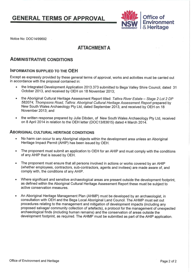
The Bega Local Aboriginal Land Council (BLALC) have recommended that Aboriginal
objects (stone artefacts) be salvaged/collected from certain areas in the
subdivision footprint.
The
assessment report was referred to OEH for consideration under the Integrated
Development process. OEH requested additional information in March 2014 in
relation to compliance with OEH’s initial comments on the masterplan and
also requested evidence of Aboriginal stakeholder consultation, which was
subsequently provided directly to OEH.
General
Terms of Approval (GTA’s) for the subdivision were subsequently issued by
OEH dated June 2014. The conditions of the Approval include compliance with the
recommendations and conservation measures identified in the NSW Archaeology
Aboriginal Cultural Heritage Assessment Report. An Aboriginal Heritage
Management Plan (AHMP) must also be developed by an archaeologist, in
consultation with the Local Land Council and OEH.
An amendment
to the road design and lot layout was also referred to OEH for comment to
ensure their GTA’s would not be affected by the design change. OEH
confirmed in May 2015 that the subdivision layout is consistent with the
previously issued GTA’s and therefore those remain valid.
Department of Primary
Industries (Fisheries)
The subject
land is within proximity of nominated Priority Oyster Aquaculture areas in the
Bega River and as such was referred to Department of Primary Industries
–Fisheries (DPI Fisheries) for consideration under the provisions of
State Environmental Planning Policy No 62 (Sustainable Aquaculture).
DPI
Fisheries recommended all proposed safeguards and measures to minimise
environmental impacts as detailed in the Statement of Environmental Effects by
Cowman Stoddart P/L and Appendices (dated October 2013), including the Water
Cycle Management Study by SEEC P/L (dated September 2013), are fully
implemented. Council staff recommends this would form a condition of consent,
should the application be approved.
DPI
Fisheries also recommended the residual rural lot (proposed Lot 33) should
include a public foreshore reserve at least 50 metres wide, extending along the
entire foreshore of the Bega River which is dedicated to Council. DPI Fisheries
recommended this reserve should be revegetated with native species where necessary
and public access points provided at strategic locations for recreational use,
including fishing.
As mentioned
previously in this report, Council staff are preparing a Planning Proposal
which would appropriately zone the subdivision area of Lot 2 but also seeks to
rezone the area of residue land. Council has already resolved to zone an area
around the foreshore perimeter to E2 Environmental Conservation which would
effectively achieve a 100 metre foreshore reserve (when combined with the
existing Council owned E2 zoned reserve).
In addition,
Council is proposing to zone an area of the river flat land RE1 Public
Recreation. Access to this area of the allotment would suitably be dealt with
in a future subdivision stage and likely under a separate masterplan for the
residue lands.
The proposed
reserve dedication of 22.16 hectares on the eastern side of the subdivision
adjacent to Blacka Ada Swamp is considered by staff to provide adequate
opportunities for public access, which is appropriate for this stage of the
subdivision.
Department of Primary
Industries (Water)
The subject
land comprises Waterfront Land for the purpose of the Water Management Act
2000 and is therefore subject to the Integrated Development assessment
process. The application was considered by the Department of Primary Industries
Water (DPI Water) (previously known as the NSW Office of Water) and it was
noted the majority of the proposed subdivision and associated works are located
more than 40 metres from any river, lake or wetland, not on waterfront land and
consequently those works would not be subject to a Controlled Activity
Approval. The design of the subdivision is generally considered to be
consistent with departmental guidelines for riparian buffers and development
setbacks.
However, DPI
Water do note the design details associated with the construction and
development of the site have not been finalised, as these would come with any
future construction certificates for the subdivision works. It is noted the
required works for walking tracks, drainage and landscaping may be located on
waterfront land, and would therefore require a Controlled Activity Approval for
those components of the subdivision.
As such
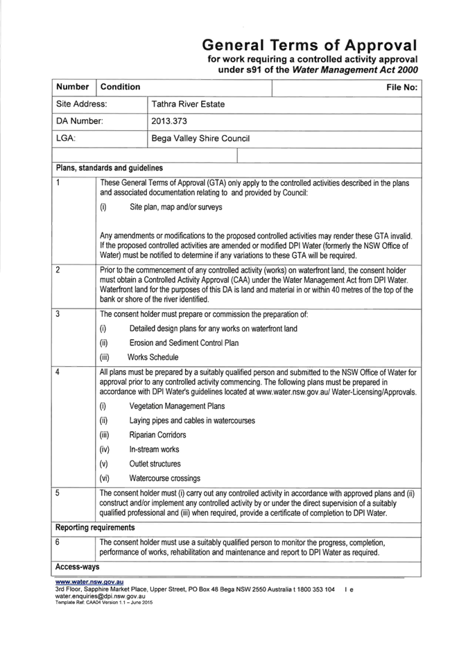
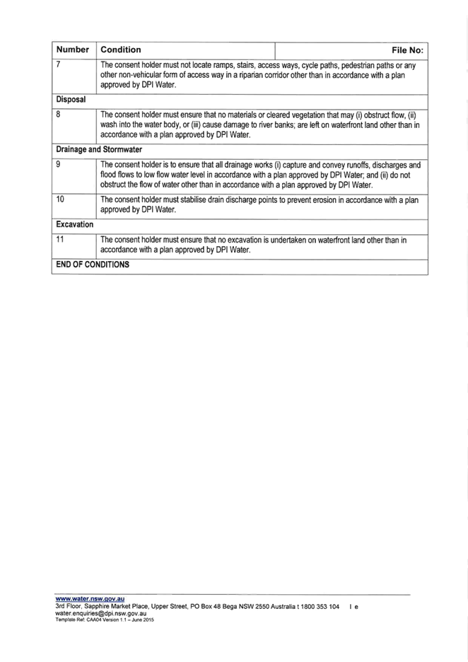
General Terms of Approval have been issued by DPI Water and would form an appendix
to any development consent issued in relation to the subdivision.
NSW Trade and Investment
(Crown Lands)
The
development application was referred to Crown Lands for information as an
adjoining landowner, being the Crown Reserve lands to the east and south. The
Crown response was as follows:
“The proposed development
includes a pedestrian/cycleway which skirts the edge of the development and is
proposed “to link with existing track to beach”. Crown Lands does
not support the use of Crown land for services or amenity to service to support
adjacent freehold development.
The proposed link must not be relied
upon to address concerns with inadequacies of bushfire access within the
development site. Although the “existing track” is a fire trail it
may not be suitable for access or egress at the time of a bushfire event or at
other times”.
The position
of Crown Land is noted and Council staff are satisfied the proposed subdivision
has adequate bushfire mitigation measures in place, including compliant Asset
Protection Zones for each allotment, adequate public road access and suitable
services and infrastructure for this style of subdivision.
Council is
the Trustee of the adjoining Reserve to the east. The fire trail is currently
maintained by Council and is considered to be suitable for its intended
purpose. It is not proposed for regular vehicular access to be available over
the Reserve lands but in the event of a bushfire the existing track could be
utilised by emergency vehicles.
There are
existing well used informal cycle tracks through this area of Reserve and it is
considered that providing a walking path link to the Reserve would not be
inconsistent with the passive recreation use of the Reserve.
The
subdivision also proposes dedication of additional lands as Reserve, which will
become Shire Property (that is dedicated to Council and not the Crown, which is
consistent with the requirements of Crown Lands). Therefore, the proposal to
provide additional public access to these areas is considered appropriate.
It is
recommended a fire trail gate be erected (at the head of the cul-de-sac bulb
adjacent to proposed Lots 31 and 32) to prevent unauthorised vehicular access
through to Crown Reserve to Tathra-Bermagui Road. A suitable condition of
consent is recommended in the draft consent provided as an attachment to this
report.
Submissions
The
development application was placed on exhibition for a period of 14 days from 20
November 2013 until 4 December 2013. This exhibition period was extended for an
additional 14 days until 18 December 2013. A total of 15 submissions were
received in relation to the development. Amended plans were received which
addressed staff concerns regarding road design and gradients and these were
renotified to adjoining and adjacent landowners between 2 March 2015 and 16
March 2015. A total of 7 submissions were received during this second
exhibition period.
A copy of
all submissions will be available at the Council meeting.
The key
themes extracted from submissions were in relation to:
|
KEY THEME
|
INCLUDING ISSUES ASSOCIATED
WITH;
|
|
Traffic
generation and road network capability
|
· The need for
traffic calming measures
· Road and
intersection capacity
· Emergency access
· Bus route
|
|
Compliance
with Masterplan
|
|
|
Environmental
impacts
|
· Flora and fauna
impacts
· Bushfire
· Onsite effluent
disposal
· Soil and water
management
· Weed eradication
|
|
Visual
amenity and character
|
· Potential view
impact
· Character of the
resulting subdivision
|
|
Servicing
|
|
|
Recreational
use of reserve lands
|
· The need for access
to foreshore areas
· The need for
recreation facilities
|
|
Future
stages of development
|
· What is the
future zoning of the residue land?
· What is the
likely future development potential?
|
The majority of these issues have
been specifically addressed in the body of this report however further detailed
comment is provided in Attachment 4 to this report.
Where
appropriate, suitable conditions of consent have been recommended to address
and mitigate any adverse impacts on the environment and the public.
On balance,
it is considered the proposed development would be in the public interest and
approval of the application is recommended.
Conclusion
The proposed
development meets the objectives of the zone, is a permissible land use, is
considered to achieve the orderly and economic use and development of land
(consistent with the objects of the Environmental Planning and Assessment
Act 1979) and is consistent with the SEPP 71 masterplan for the land.
A wide range
of impacts have been identified in the assessment of the application and, where
appropriate , suitable mitigating measures have been identified, either through
the provision of revised plans and additional information from the applicant,
or through recommended consent conditions.
In
considering all relevant matters under Section 79C of the Environmental
Planning and Assessment Act 1979, the proposed development would be
suitable for the subject site and approval of the application would be in the
public interest.
Approval of
the development is recommended subject to conditions provided in the draft
consent as Attachment 5 to this report.
Attachments
1. Subdivision
Plan
2. Locality
and Zoning Map
3. Subdivision
overlay with traffic calming locations
4. Summary
of submissions
5. Draft
consent conditions
|
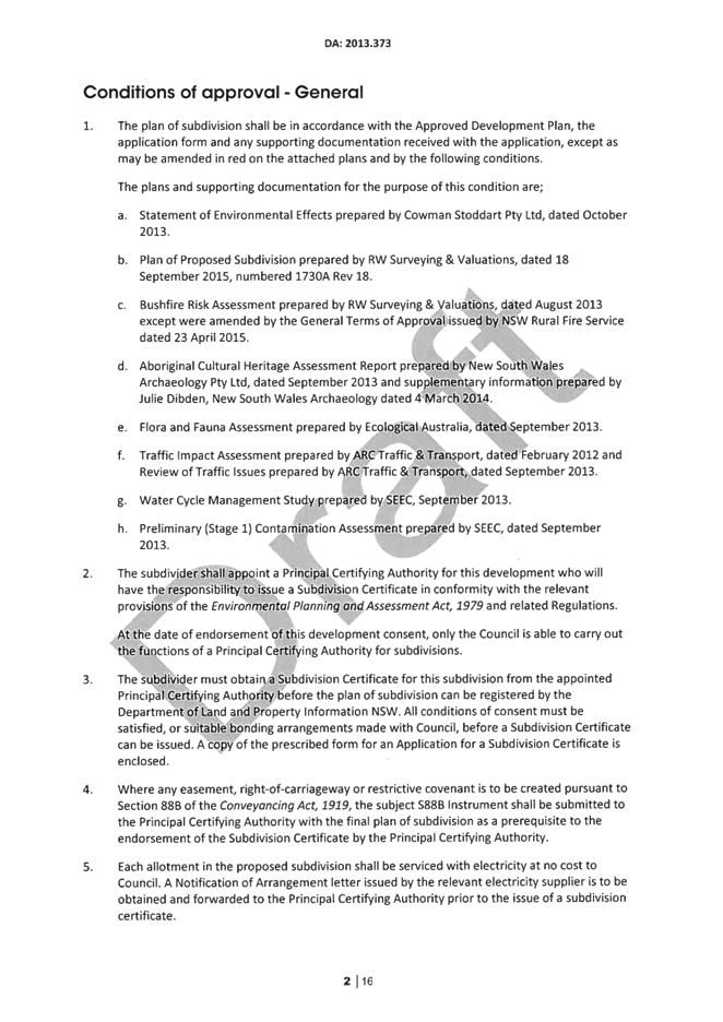
Recommendation
1. That
Development Application 2013.373 for a 33 lot subdivision at Lot 2 DP 582074
Thompson Drive, Tathra be approved subject to conditions as provided as
Attachment 5 to this report.
2. That
those persons who made a submission be advised of Council’s decision in
this regard.
|
|
Council
|
14 October 2015
|
|
Item 8.1 - Attachment 1
|
Subdivision Plan
|
|
Council
|
14 October 2015
|
|
Item 8.1 - Attachment 2
|
Locality and Zoning Map
|
|
Council
|
14 October 2015
|
|
Item 8.1 - Attachment 3
|
Subdivision overlay with traffic calming locations
|

|
Council
|
14 October 2015
|
|
Item 8.1 - Attachment 4
|
Summary of submissions
|


|
Council
|
14 October 2015
|
|
Item 8.1 - Attachment 5
|
Draft consent conditions
|


|
Council 14
October 2015
|
Item 8.2
|
8.2. DA No.
2015.82: Regularisation of unauthorised additions to attached dual occupancy, 2
Coraki Drive, Pambula Beach
Group Manager Planning and Environment
|
Applicant
|
Robert Pointon
|
|
Owner
|
RW & MD Pointon
|
|
Site
|
Lot 46 DP 1054833, 2 Coraki Drive, Pambula Beach
|
|
Zone
|
R2 Low Density Residential
|
|
Site area
|
3,864 metres square
|
|
Proposed development
|
Regularisation of unauthorised alterations and additions
to attached Dual Occupancy
|
Precis
Council is in receipt of a Development
Application (DA) for the regularisation of unauthorised alterations and
additions to an attached dual occupancy, comprising a water tank with supporting rock retaining wall, a timber and steel deck
10.5 metres x 4 metres, concrete supporting structure and spa pool.
A total of 327 submissions were
received raising objection to the development.
The application is reported to
Council for determination on the basis of the broader public interest
considerations for the locality.
The DA is recommended for
refusal. Staff also recommend commencement of legal proceedings in relation to
the breach of the Environmental Planning and Assessment Act 1979.
Background
In 2007,
Council issued a Development Consent (2007.137 ) for demolition of an existing
dwelling and erection of an attached dual occupancy.
The approved
plans endorsed a landscape detail that included a 20,000 litre water tank to be
located behind existing sheds, adjacent to the south-west property boundary.
The approved plans did not endorse any plan or specification for a water tank.
This is not an uncommon practice as domestic rainwater tanks constructed of
this capacity are commonly only 2-3 metres in height. Had the water tank been
constructed in the approved location, it would have been screened by the
existing sheds on the property.
Without
consultation with Council, the property owner decided the tank would be constructed
approximately 10m to the north of the approved location and in a slightly
elevated position.
Work progressed from that point to what now
appears today as a substantial mass rock retaining wall, water tank (with an
approximate 12,500 litre capacity) attached to which is a concrete tower with a
timber and steel deck platform, designed to accommodate a spa pool.
Council became aware of works being undertaken on
the land via public concern. As a result of a site inspection and onsite
meeting, the owner was advised to cease works and submit a DA for the
consideration of Council.
Following initial assessment, the applicant was
requested to consider issues raised in regard to impacts on visual amenity,
bulk and scale. Staff suggested that the applicant may wish to provide
additional supporting information relating to possible treatments of both the
structure and the provision of suitable vegetation screening. Landscaping
and colour treatment details were subsequently submitted by the applicant and
have been considered in the assessment of the development application.
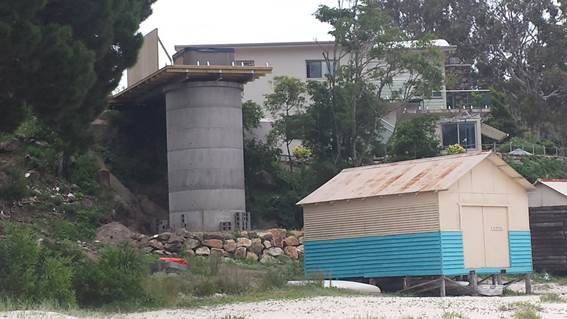
Photograph of structure when viewed from Pambula River
mouth.
Description of the proposal
The DA seeks regularisation of
unauthorised alterations and additions to an attached dual occupancy,
comprising a water tank with supporting
rock retaining wall, a timber and steel deck 10.5 metres x 4 metres, concrete
supporting structure and spa pool.
A copy of the development plans is provided as
Attachment 1 to this report.
Description of the site
The subject land is an irregular shaped block of
3,864 square metres, with road frontage to Coraki Drive and foreshore to the
Pambula River estuary. The site accommodates an attached dual occupancy and
various outbuildings. An internal concrete driveway accesses the land
from Coraki Drive up to and including a metal shed and continues through to an
unnamed laneway to Taleban Street.
A Locality Plan is provided as Attachment 2 to
this report.
Planning assessment
The proposal
has been assessed in accordance with the Matters for Consideration under
Section 79C of the Environmental Planning and Assessment Act 1979. The
assessment has also included consideration of the objectives of State
Environmental Planning Policy 71 (Coastal Protection).
A copy of
the assessing officer's Section 79C assessment will be available at the
meeting.
Zoning
The subject
land is zoned R2 Low Density Residential Zone under the provisions of the Bega
Valley Local Environmental Plan 2013 (BVLEP 2013). The proposed development
would be defined as ‘structures ancillary to an attached dual
occupancy’, which is permissible with development consent.
The
objectives of the R2 Low Density Residential Zone are as follows;
· To
provide for the housing needs of the community within a low density residential
environment.
· To
enable other land uses that provide facilities or services to meet the day to
day needs of residents.
The
objectives of the zone have been considered in the assessment of this application.
Issues
The
assessment of the application has identified several key issues which are
discussed in detail below.
Impact on a sensitive coastal location
The subject
site is located within the Coastal Zone and is identified as a ‘sensitive
coastal location’ for the purpose of State Environmental Planning Policy
71 (Coastal Protection). In considering any development within the coastal zone
a consent authority must have regard for the relevant objectives and provisions
of the SEPP.
Staff have identified the following matters are
particularly relevant to the application currently before Council;
Clause
2 objectives:
(e) to ensure that the
visual amenity of the coast is protected; and
(k) to ensure that the
type, bulk, scale and size of development is appropriate for the location and
protects and improves the natural scenic quality of the surrounding area;
Clause
8 matters for consideration:
(d) the suitability of
development given its type, location and design and its relationship with the
surrounding area.
Clause 5.5 of BVLEP 2013 is also
relevant to the assessment of this application, in particular the need for a
consent authority to be satisfied that the principles of the NSW Coastal Policy
are implemented. The following is most relevant to this application;
(1) (b) to:
(i) protect, enhance,
maintain and restore the coastal environment, its associated ecosystems,
ecological processes and biological diversity and its water quality; and
(ii) protect and preserve the
natural, cultural, recreational and economic attributes of the NSW coast; and
(v) protect amenity and scenic
quality; and
(vi) protect and preserve rock
platforms, beach environments and beach amenity; and
(vii) protect and preserve native coastal
vegetation;
(ix) ensure that the type, bulk,
scale and size of development is appropriate for the location and protects and
improves the natural scenic quality of the surrounding area; and
(x) ensure that decisions in
relation to new development consider the broader and cumulative impacts on the
catchment; and
(xii) protect and preserve items of
heritage, archaeological or historical significance.
The subject
site is located adjacent to a significant area of public open space which
connects with the Council reserve at the end of Coraki Drive, proceeds along
the Pambula River foreshore and on to the Pambula River Walking track located
in the adjoining Ben Boyd National Park.
This section
of the foreshore provides an important interface between the coastline, the
estuary and adjoining residential areas. Staff consider that the proposal is
inconsistent with the objectives and principles of the NSW Coastal Policy, SEPP
71 and BVLEP Clause 5.5 in that the development results in an over-scaled,
overbearing structure adjacent to foreshore reserve and is not in context with
the natural setting in which it has been located.
Impact on the amenity of the public domain
In
considering the applicants request to regularise the existing structure, staff
have had regard to the planning principles established in Rose Bay Marina
Pty Limited v Woollahra Municipal Council and anor [2013] NSWLEC 1046. The
framework of the planning principle concerning impacts on views enjoyed from
the public domain is broadly consistent with (but not identical to) the matters
raised for consideration in Tenacity (which sets out the planning
principle for considering the acceptability of the impact of a proposed
development on the views enjoyed from private property in the vicinity of the
development). The process for considering public views must account for
reasonable development expectations as well as the public enjoyment of outlooks
from public places.
The key
public places which were identified for the purpose of assessing impact were
the Pambula River mouth reserve and foreshore areas and the adjoining National
Park.
Staff
consider that the placement of a such a substantial solid and imposing
structure has significant adverse impacts on the amenity of the adjoining
public domain. The location, size and design of the structure breaks the visual
linkage between the natural landscape and the residential area above. The
materials used and the overall bulk and scale of the structure are also
considered to be out of character with this coastal foreshore setting.
In addition,
the structure is of a size and has used materials that dominate the landscape
and has no spatial relationship or design connectivity with the old timber
beach huts located in the immediate vicinity, which forms part of the important
visual link to the passive recreation amenity and enjoyment of the area and its
iconic character.
The
applicant was encouraged by staff to explore design treatments that may
mitigate the severe visual impact of the tower’s concrete column.
Additional information was submitted to Council for consideration that included
the painting of the tower and planting of additional landscaping at the base of
the tower, which would include the planting of semi-mature trees.
After
reviewing the additional detail, staff conclude that the proposed treatments
would have little effect in negating the visual dominance of the tower when
viewed from both the adjoining foreshore areas and the National Park.
Staff
consider that a more skilful and considered design could have achieved the
reasonable expectations of the applicant whilst minimising the impact on the
public domain. Staff conclude that the development as constructed is
unreasonable and therefore cannot support regularisation of the development.
Height, bulk and scale
Height
The proposal
exceeds the building height development standard of Clause 4.3 of BVLEP 2013 by
1.5 metres. This results in a built form which unreasonably contributes to the
bulk and scale of the development and has an adverse impact on the foreshore
amenity of the adjoining public lands.
The
objectives of BVLEP 2013 Clause 4.3 Height of Buildings are as follows;
(1) The
objectives of this clause are as follows:
(a) to retain the
existing character and landscape of the locality and to encourage a low-set
building form;
(b) to protect
residential amenity, views, privacy and solar access.
(2) The height of a
building on any land is not to exceed the maximum height shown for the land on
the Height of Buildings Map.
The maximum
building height for this site is 7.5 metres. The term ‘building’ is
defined to include “part of a building and any structure or
part of a structure but not including a manufactured home, a moveable dwelling
or associated structure..”.
A
conservative interpretation of the structure height from both site inspection
and from submitted plans confirms an overall height of 9 metres, representing a
variation of 1.5 metres.
The
combination of both the overall height and the use of materials result in a
structure that is not sympathetic to the location and therefore staff consider
the development fails to satisfy the objectives and overall height limitations
stipulated in Clause 4.3 of the BVLEP 2013.
Bulk and scale
It appears
that the applicant has constructed the tower in part to utilise the opportunity
to place the spa at a level with unimpeded views to the estuary. It is the view
of staff that an improved design could have been achieved by placement of the
spa on natural ground at or near the level of the second storey of the existing
residential development. Such a location would have been in keeping with the
existing residential and beach interface, while at the same time retaining
reasonable view and amenity for the landowner. This alternative location and
design would have maintained the views and amenity afforded to the public from
the adjoining beach areas.
The location
and design of the structure is considered to be unreasonable and staff cannot
support regularisation of the development for the reasons highlighted in this
report.
Consultation
National Parks & Wildlife
As the
property adjoins the Ben Boyd National Park, staff consulted with the Office of
Environment and Heritage (OEH).
The OEH
response provided identifies not only concern that the structure was built
without appropriate planning approval, but also expressed the opinion that it
has a significant impact on the visual amenity of the Pambula River Estuary.
OEH is of the view that proposed works to mitigate the impact would not be
successful as the vegetation screening is unlikely to adequately cover the
structure and the primary planting chosen to screen the area is a species that
is not likely to grow well in this location.
Submissions
The development
application was placed on exhibition for a period of 25 days from 25 March 2015 until 10 April 2015 and a total of 327
submissions were received.
The key
issues raised in the submissions centre on the impact that the structure has
had on the scenic amenity of this coastal estuary and clearly express the
community’s attachment to the natural landscape amenity of the locality
and the desire to ensure development impacts are minimised.
A number of
the submissions draw Council’s attention to the fact that appropriate
consideration of the design has not been possible because the structure has in
fact been substantially erected. It is suggested that if properly considered,
Council would have formed the view that any structure in this locality of
similar height and size would not have obtained consent to proceed.
While some
of the submissions have no bearing on matters relating to Council’s
assessment, staff support the general view of the submissions that the
structure has an unacceptable impact on what is an iconic south coast setting.
A copy of
the submissions will be available at the Council meeting.
Legal
The
retaining walls, tower, deck and spa form an overall structure that required
both development consent and construction certification. Detailed planning,
organisation and co-ordination of engineering design, sub trades and labour
would have been needed to execute what are significant works that required
engineering certification for a complex design that incorporates substantial
foundations and other structural considerations.
It is
difficult to rationalise why the applicant believed that no approval was
necessary for a structure of this magnitude. A simple enquiry to Council would
have cleared any doubt as to a requirement for an approval. Staff can only
speculate that the owner’s intent was to erect the structure and be
concerned about repercussions after the event.
As the works
proceeded without consent it is difficult to determine the extent of vegetation
that would have existed both at the base and over the natural rock wall in this
location. It is obvious that given the extent of vegetation on both sides of
the tower that it is likely that substantial vegetation cover may have been
removed.
A further
concern in regard to development proceeding without any approval is that
assessment has not been undertaken of possible indigenous cultural heritage
that are commonly encountered in similar estuary locations in the Shire.
Staff are of
the view that the erection of the structure represents a serious breach of a
legislative requirement to obtain approval to ensure that relevant matters
including design and impact (not only to the landscape but importantly to
public amenity) are taken into consideration. It is recommended that not only
should the owner of the land be required to remove the unauthorised structures,
but should also be prosecuted for the offences related to the erection of the
structure.
While staff
have the necessary delegations to prosecute the offence it is important that
this matter be reported to Council to highlight to the community the importance
of ensuring that appropriate approvals are in place prior to undertaking
development.
It also
serves to inform the community that Council does take matters of this nature
seriously and will take action in such circumstances.
Conclusion
The
development application seeks to obtain approval for structures built without consent.
While it is
unclear as to the motive and the rationale considered by the owner at the time
of construction, it is clear that the works have had an unacceptable impact on
the scenic beauty of this coastal estuary.
Assessing
staff are of the view that this impact cannot be mitigated by either treatments
to the tower or by use of vegetation screening.
As such, the
application is recommended for refusal for the reasons contained within this
report. Staff also recommend that notice be served on the owner to remove the
unauthorised structures and that the owner should be prosecuted for failing to
obtain the relevant consent and construction certification prior to the
erection of the retaining wall, concrete tower and steel and timber deck.
Attachments
1. Development
Plans
2. Locality
Plan
Recommendation
1. That
Development Application 2015.82 for the regularisation of unauthorised
alterations and additions to an attached dual occupancy (including a rock
retaining wall, concrete tower, deck and spa) be refused for the following
reasons:
a. The
proposed development fails to comply with the maximum building height
development standard set by Clause 4.3 of the BVLEP 2013 and is inconsistent
with the objectives of the clause in that the development does not retain the existing character and amenity of
the locality.
b. The
proposed development is inconsistent with
the objectives of Clause 5.5 of the BVLEP 2013 and the principles of the NSW
Coastal Policy as the development would have an unacceptable impact on
a sensitive coastal location, being the Pambula River mouth and its environs
in terms of scenic quality and amenity.
c. The
proposed development is inconsistent with the objectives of SEPP 71 Coastal
Protection as the development fails to ensure the visual amenity of the coast
is protected and the type, bulk, scale and size of the development is
inappropriate for the location. Further the development fails to protect and
improve the natural scenic quality of the surrounding area.
d. The
proposal would not be in the public interest.
2. That
Council serve notice on the owner to have the unauthorised structure
demolished.
3. That
the property owner reinstates vegetation to the satisfaction of Council to a
standard consistent with the extent of vegetation that currently exists on
either side of the tower as it currently stands.
4. That
legal proceedings be commenced against the owner of the property seeking
prosecution for undertaking the construction of the retaining wall, tower and
deck without development consent.
5. Those
parties who made a submission be advised of Council’s decision.
|
|
Council
|
14 October 2015
|
|
Item 8.2 - Attachment 1
|
Development Plans
|
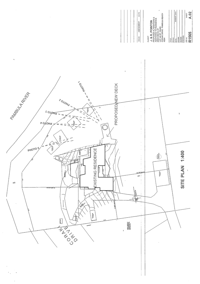
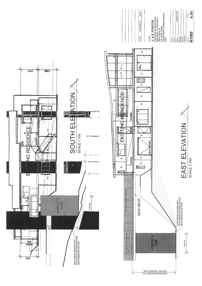
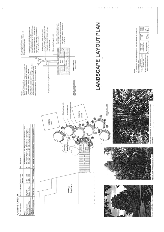
|
Council
|
14 October 2015
|
|
Item 8.2 - Attachment 2
|
Locality Plan
|
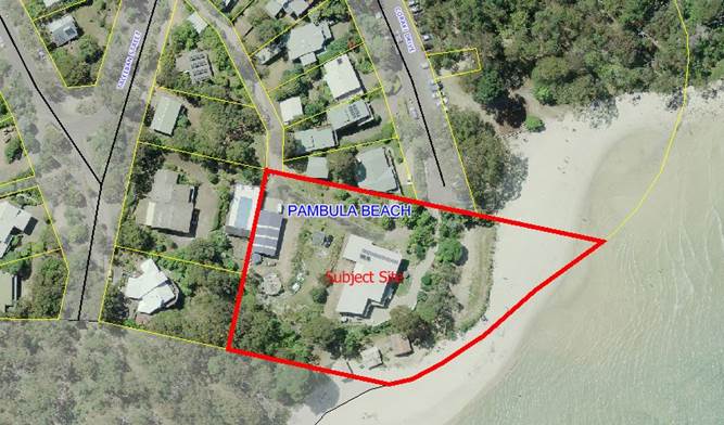
|
Council 14
October 2015
|
Item 8.3
|
8.3. DA No.
2012.393: Section 96 application to modify condition 5 - Alterations and
additions to entertainment establishment - Four Winds Barraga Bay
Group Manager Planning and Environment
|
Applicant
|
Four Winds Inc.
|
|
Owner
|
As above
|
|
Site
|
Lot 130 & 131 DP 1178806, 3511 Tathra-Bermagui Road, Barraga
Bay
|
|
Zone
|
E3 Environmental Management
|
|
Site area
|
23.841 ha
|
|
Proposed development
|
Alterations and additions to an Entertainment
Establishment including the erection of a performance pavilion, access road,
parking and ancillary infrastructure and intensification of the use.
|
Precis
Council is
in receipt of a Section 96 (2) Application to modify condition 5 of Development
Consent 2012.393 which requires the sealing of the internal access road prior
to 2016.
The Section
96 (2) Application to Modify is being reported to Council as the matter has
been the subject of a previous Council resolution.
The Section
96 (2) Application to Modify is recommended for refusal.
Background
Development
Consent No. 2011.228 was issued on 6 September 2011 for an Entertainment
Establishment (bi-annual open air music concert) and associated infrastructure
including performance stage, canopy and amenities.
The approved
development included a condition requiring the construction of a new internal
entry road, off Four Winds Road, prior to the 2018 event taking place. This
internal road was to be constructed to a 4m wide gravel standard, except for
any part of the road which exceeded a 15% grade, which was to be bitumen
sealed.
Access to
the site prior to 2018 would be via an existing right of carriageway over
adjoining land.
It should be
noted the internal access road has been constructed and is the main access to
the Entertainment Establishment.
Development
Consent No. 2012.393 was issued on 11 March 2013 for Alterations and Additions
to an Entertainment Establishment including erection of a performance pavilion,
access road, parking and ancillary infrastructure and intensification of the
use.
The Consent
approved the increase in events from bi-annual to:
a) four
major events per year that shall not exceed 2000 patrons at the event at any
one time and the duration of which shall not exceed two consecutive days per
event subject to compliance with Condition;
b) one
minor event per month that shall not exceed 500 patrons at the event at any one
time;
c) the
unlimited use of the performance pavilion which shall not exceed 160 patrons.
Condition 5
of the Consent required the following;
“The applicant shall provide a 4m
wide two coat bitumen seal of the formed access approved under DA No 2011.228
prior to any event occurring on-site.”
Four Winds
Inc. lodged a Section 96 application to modify a number of the conditions of
Development Consent 2012.393 including the deletion of condition 5.
In support of
the request the applicant submitted the following –
“We seek deletion of this
condition. We appreciate if money was no constraint that a sealed road would be
the ultimate surface for pavement stability long term and would lessen actions
needed for dust control. But previous Council advice was that a road of 15% or
less would not require sealing and the current gravel pavement was approved for
the road Construction Certificate. Further TTM advise the proposed volume of
use does not warrant sealing. Four Winds accept they will be required to effect
watering for dust suppression and to keep the gravel pavement maintained, with
good drainage to limit gravel loss.”
“We note Council has seen fit to
approve the current biennial festival on the basis of an ongoing gravel
formation.”
The
application was determined under the Delegated Authority of the Group Manager
Planning and Environment with the request for deletion of condition 5 refused.
The
applicant lodged a Review of Determination with Council requesting a review of
the decision refuse the deletion condition 5.
Council at
its meeting on 6 November 2013 considered the Review of Determination and
modified the wording of Condition 5 to read;
“the formal access approved under
DA No 2011.228 shall be provided with a 4m wide 2 coat bitumen seal in
accordance with the following timeframes:
· The first 200 metres from the
intersection with Four Winds Road prior to any event occurring;
· The remainder of the access prior to
2016.”
The Section
96(2) Application to Modify currently before Council seeks to remove the
requirement for the sealing of the remainder of the road by the removal of the
words, “The remainder of the access prior to 2016.” from Condition
5.
Details of the applicant’s request for modification
In support of
the Section 96(2) Application to modify, the applicant submitted the following;
“Our justification for the request
is that the road is in excellent condition and does not need to be sealed and
it is therefore an unreasonable request. It is also an unreasonable request
because the original DA for the Sound Shell DA 2011.0228 and for which we built
the road, did not require sealing the road and any extra usage since building
the Pavilion, is for small numbers, as the Pavilion DA only allows for
audiences of 180 people inside that new space.
It will benefit all of us if we were
able to spend our very limited resources on meeting the Council’s social
planning objective of ‘bringing to life through music’…
We have now been using this road since
2013, including for the construction of the Windsong Pavilion, and it has
remained in excellent condition, despite heavy vehicle use during construction.
At Council’s request we sealed that part of the road that was the
steepest and this part of the road remains in excellent condition also. We have
since held Festival 2014 with nearly 2000 patrons, Carols by Candlelight with
800. There have been monthly Pavilion events of around 160 patrons each.
There was torrential rain for the
funeral service for our founder Neilma Gantner on 18 June 2015 and the main
Tathra/Bermagui road was closed at Wapengo. Our road, however, easily withstood
the usage for this event, and there were several buses which were transporting
family members from Merimbula airport to the Four Winds site.
We have not needed to grade the road.
There is no erosion, and there are no sedimentation impacts, nor any dust
impacts for neighbours or the bushland. The type of gravel surface produces
minimal dust, however, we are now purchasing our own road watering system to
spray the road ahead of any event should it be the road be dry and dusty. We
routinely used to water the dust on the old road during our Festival, with the
use of a hired water truck. So far spraying has not been necessary on the new
road, but we are ready if it is needed.”
Staff Comment:
The site was
inspected on the 16th September 2015 to review the condition of the unsealed
sections of the access. The inspection revealed the surface was in good
condition with only minor wear and tear. Some minor erosion scouring of the
southern table drain has occurred while a small erosion rill is beginning to
form within the central unsealed section of the access.
There was no
dust generated while the access was traversed during the inspection. Several
photographs of the access are included on file and available at the Council
meeting.
Although the
unsealed section was in reasonable condition during the inspection, Council
staff still maintain the remainder of the access road should be sealed for the
reasons previously reported to the Council meeting held on 16 October 2013 and
included below;
“Condition
5 was placed on the approval as the development application proposed to
increase events at the site from one concert every two years, to 4 major events
per year attracting up to 2000 patrons, 12 minor events per year attracting up
to 500 patrons and unlimited use of the performance pavilion that may
accommodate up to 160 patrons (now…250…).
“The
increase in use of the site is significant when the current development approval
under DA 2011.228 is for an event every two years that only permits up to 1500
patrons and required the access to be suitably constructed to accommodate for
that use.
“The
TTM report states that generally gravel roads or unsealed surfaces warrant sealing
at around 150-200 AADT vehicle movements. The Average AADT for the proposal was
calculated by TTM at around 60 daily vehicle movements and they concluded that
they see no warrant to seal Four Winds Road consequent to the proposed activity
schedule.
“Condition
5 only requires the sealing of the internal access handle, not Four Winds Road.
The requirement for sealing was partly due to the additional vehicles that
would be generated by the development as the assessed 60 average vehicle
movements being generated is the equivalent of 10 new dwellings as detailed
under DCP 2 – Subdivision Standards.”
“Given
the significant increase in traffic to be generated by the development and the
grade of the access, it is considered appropriate that Condition 5 remain to
ensure that soil erosion and sedimentation from runoff off the access road does
not impact on the watercourse that traverses under the access road.”
Conclusion
The
requirement for the sealing of the internal access road has been the subject of
a previous Section 96(2) Application to Modify and also a Council resolution at
its meeting on 6 November 2013.
Council
staff maintain that the balance of the internal access road should be sealed in
accordance with the requirements of condition 5 for the reasons outlined in
this report.
The Section
96 (2) Application to Modify is recommended for refusal.
Attachments
Nil
Recommendation
That
Council refuse the Section 96(2) Application to Modify Condition 5 of DA No
2012.393 for the following reasons:
1. The
condition was imposed to address the existing amenity for the adjoining
residents and protection of the environment.
|
|
Council 14 October 2015
|
Item 8.4
|
8.4. Companion
Animals Control Procedure
The purpose of the report is
to inform Council on the review of the Companion Animals Control Procedure and
recommends public exhibition of the revised Procedure.
Group Manager Planning and Environment
Background
In 2010 Council adopted a Companion Animals Control
Procedure which describes Council's requirement for the management of companion
animals within the terms of the Companion Animals Act 1998. This
Procedure also provided advice to the community including responsibility of
animal ownership, wildlife protection areas, leash free areas and general areas
where dogs may be prohibited.
This Procedure was listed for revision in 2015 and
following initial consultation with the community, government agencies and animal
welfare organisations, the Procedure has been revised and is now ready for
public consultation.
Consultation
Initial
consultation was carried out with the community, government agencies and
Councillors during the early half of this year. The feedback received has been
reviewed and where appropriate included in the revised document for
consideration.
It is now
proposed to place the revised Procedure on public exhibition for a minimum 28
days. In addition to information placed in local media and on Council’s
website, staff will place temporary signage in key locations to further inform
the community of the opportunity for comment.
Conclusion
The
Companion Animal Procedure provides a valuable resource for responsible pet
ownership and is important the community be provided with input into the review
process to ensure Council's statutory responsibilities and changes to community
expectations are fully considered.
Attachments
1. Draft
Companion Animals Control Areas Procedure
|
Recommendation
1. That
the Draft Companion Animal Control Areas Procedure 3.06.6 be advertised and
placed on a 28 day public exhibition period.
2. That
a further report be presented to Council following the exhibition period.
|
|
Council
|
14 October 2015
|
|
Item 8.4 - Attachment 1
|
Draft Companion Animals Control Areas Procedure
|
|
Council 14
October 2015
|
Item 8.5
|
8.5. DA No.
2015.324: Construction of self storage units - Old Wallagoot Road,
Kalaru
Group Manager Planning and Environment
|
Applicant
|
P. J. Summerell
|
|
Owner
|
TN Killalea and TE Killalea
|
|
Site
|
Lot 4 DP 775530, 1-5 Old Wallagoot Road, Kalaru
|
|
Zone
|
RU5 Village
|
|
Site area
|
1.36Ha
|
|
Proposed development
|
Construction of Self-Storage Units
|
Precis
Council is
in receipt of a development application (DA) for the construction of 140
self-storage units in two stages on the corner of Tathra Road and Old Wallagoot
Road, Kalaru.
The application is being reported to Council for determination
in accordance with Procedure 3.01.4 Councillor/Staff – lodgement of
DA’s as the applicant is a member of Council staff.
The DA was
notified to adjoining and adjacent landowners with one submission received.
The DA is
recommended for approval.
Description of the proposal
The proposal
is for the construction of 140 self-storage units in two stages; Stage one
– 37 units, Stage two – 103 units. Access to the development would
be off Old Wallagoot Road. The proposal includes 11 blocks of self-storage
units ranging in size from 18sqm to 40sqm with a maximum height of 6m.
The proposed
self-storage units would operate twenty four hours a day, seven days per week.
The proposed
units would be setback 6m from Tathra Road and Old Wallagoot Road.
The
perimeter of the site would be landscaped and a 1.8m pool style fence is
proposed to be constructed to secure the site. The units are proposed to be
constructed from colorbond steel in the colour ‘eucalypt’.
A copy of
the development plans is provided as Attachment 1 to this report.
Description of the site
The site is
a 1.36 hectare vacant block of land on the corner of Tathra Road and Old
Wallagoot Road, Kalaru. The site is relatively flat and contains an area of
riparian land toward the western corner of the lot and small patches of
vegetation along the western and southern boundaries. There are a number of
standalone trees along the northern and eastern boundaries.
The site is
surrounded by single storey residential development and adjoins a caravan park
to the south. The site has sealed road frontage onto Old Wallagoot Road.
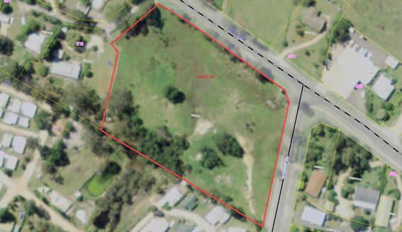
Figure 1 Aerial
photo of the subject site
Planning assessment
The proposal
has been assessed in accordance with the Matters for Consideration under
Section 79C of the Environmental Planning and Assessment Act 1979. Staff
has highlighted the key issues of the proposal in this report for
Council’s consideration.
A copy of
the assessing officer's Section 79C assessment will be available at the
meeting.
Zoning
The subject
site is zoned RU5 Village under BVLEP 2013 with ‘self-storage
units’ a permissible use in the zone with development consent.
Issues
The
assessment of the DA has identified several key issues which are discussed in
detail below.
Streetscape character and amenity
The proposed units would be setback 6m to both Tathra
Road and Old Wallagoot Road.
Extensive landscaping is proposed for both road
frontages and the western boundary however 65m of the southern boundary,
adjacent to the caravan park, would not be landscaped to allow for drainage
works and restrictions due to an easement to drain water.
Existing vegetation bordering the road reserve is
proposed to be retained.
A 1m high earth mound would be constructed between the
road reserve and proposed security fence with the landscaping planted on the
mound to heighten the impact of the landscaping and minimise any adverse visual
impact from the road.
All perimeter landscaping will be conditioned to be
completed as part of stage 1.
Restrictive Easement
There is an existing easement along the northern
boundary of the subject lot which places a user restriction on the land
prohibiting any building to be erected within 10m of Tathra Road. This easement
was created for the purposes of future road widening.
Roads and Maritime Services has been contacted with
regards to any future plans to widen Tathra Road and have informed Council
there are no such plans and that Council can amend the restriction at their
discretion.
The applicant has requested this easement be
extinguished to enable an additional 4m of driveway width to be constructed
alongside the larger bank of storage sheds that have been designated for boat
storage to allow for the car, boat and trailer manoeuvring. Landscaping as
detailed above is proposed to alleviate any adverse visual amenity impacts from
Tathra Road.
As there are no plans to widen Tathra Road it is
considered appropriate for the restriction to be removed.
It should be noted a similar easement has been extinguished
from parcels of land on the opposite side of Tathra Road.
Noise impacts
The
submitted DA identified the intention to operate twenty four hours per day,
seven days per week. As part of the assessment of the DA consideration was
given on the potential adverse impacts on the amenity of adjoining residential properties
as a result of noise from vehicles, loading and unloading of goods and voices
of users during the night would be inappropriate, and the applicant was
requested to revise the opening hours.
The
applicant amended the proposed operating hours to be from 6am to 10pm, seven
days per week. These hours of operation are considered appropriate for the
location of the proposed facility and Village setting.
Traffic generation
The proposed
development is for self-storage of personal items and items associated with
recreation (e.g. boats). It is considered any increase of traffic generation
would be minimal and not inconsistent with that of the neighbouring caravan
park.
Submissions
The DA was
placed on exhibition for a period of 14 days
from 25 August 2015 until 8 September 2015 with one submission
received.
The key
issues raised in submissions are discussed below, followed by staff comment.
A copy of
the submissions will be available at the Council meeting.
Operating hours
Comment:
Concern has
been raised in relation to potential adverse impacts on the amenity of
adjoining residential properties as a result of noise from cars, loading and
unloading of goods and voices during the night as a result of the proposed
twenty four hour operating hours.
Response:
As the
development is within the RU5 Village zone and is surrounded by a number of
residences, the concerns were raised with the applicant and the operating hours
were subsequently amended to be from 6am to 10pm, seven days per week.
Conclusion
The proposed
development is a permitted use in the RU5 Village zone, complies with the
relevant Clauses of the BVLEP 2013 and BVDCP 2013 and is considered to be an
appropriate use, subject to the amended operating hours and landscaping of the
perimeter of the site to address visual impact.
One
submission was received during the exhibition period and the issue raised
regarding operating hours has been addressed as outlined in the report.
The proposed
development is recommended for approval, subject to the conditions outlined in
the draft consent.
Attachments
1. Development
plans
2. Draft
Consent Conditions
Recommendation
1. That
Council resolve to release the restriction to user over Lot 4 DP 775530 Old
Wallagoot Road, Kalaru to enable the easement to be extinguished.
2. That
Development Application No. 2015.324 for the construction self-storage units
at Lot 4 DP 775530, 1-5 Old Wallagoot Road, Kalaru be approved subject
to conditions as provided in the draft consent attached to this report.
3. That
those parties who made a submission be advised of Council’s decision.
|
|
Council
|
14 October 2015
|
|
Item 8.5 - Attachment 1
|
Development plans
|
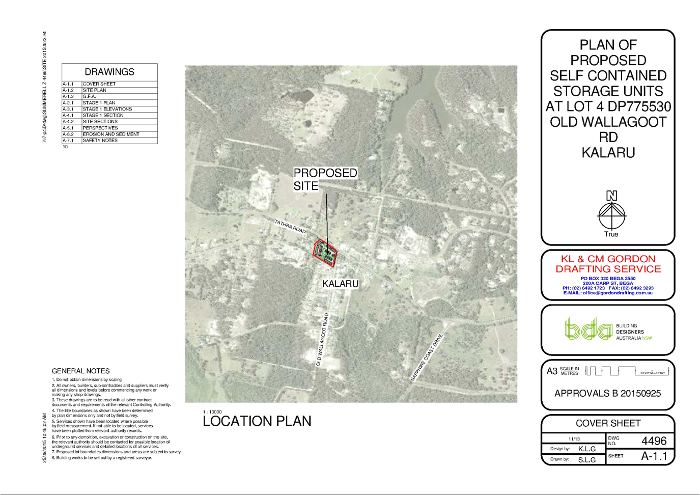
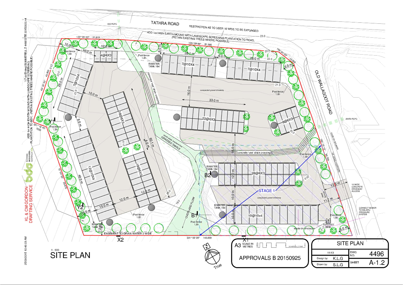
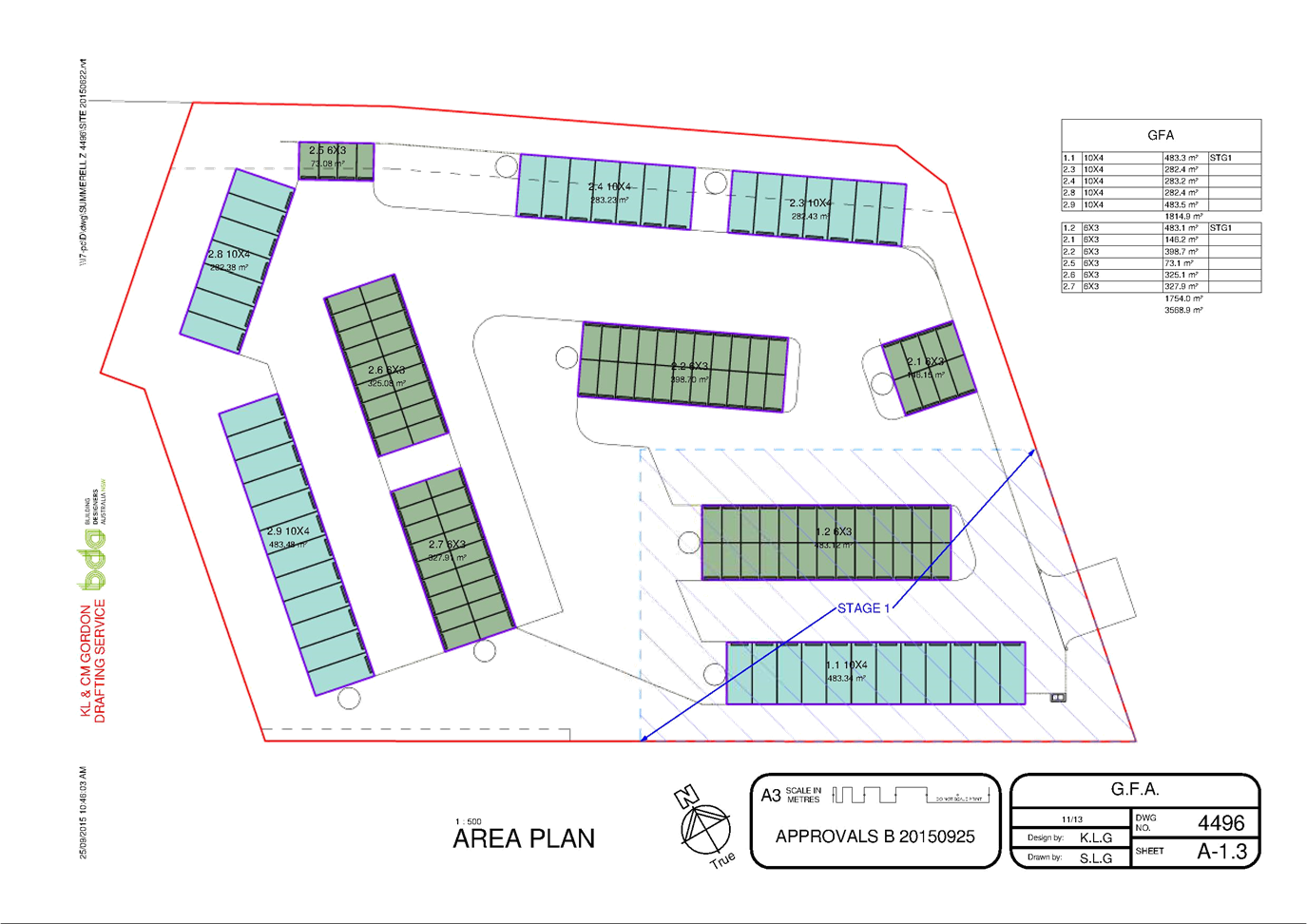
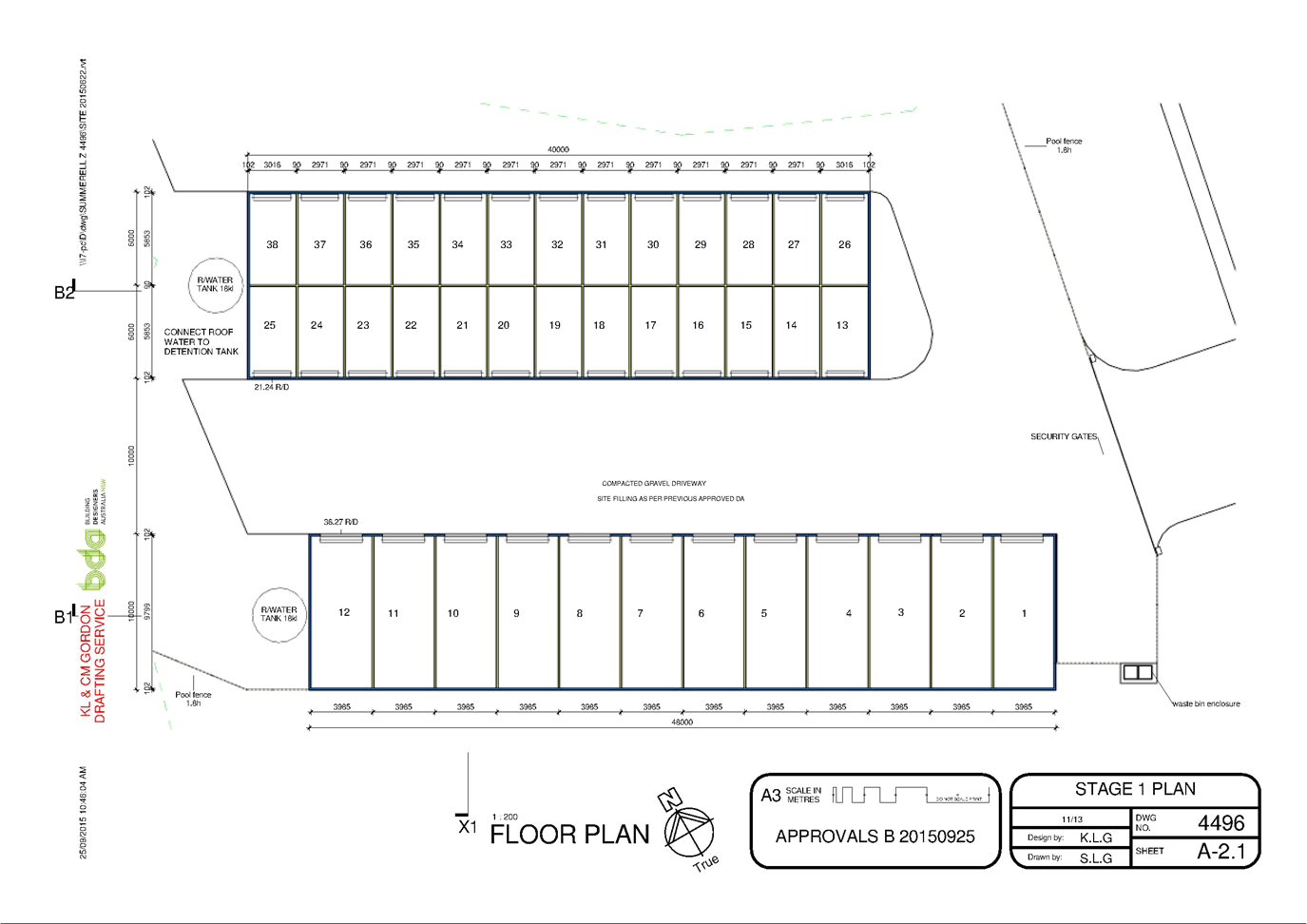
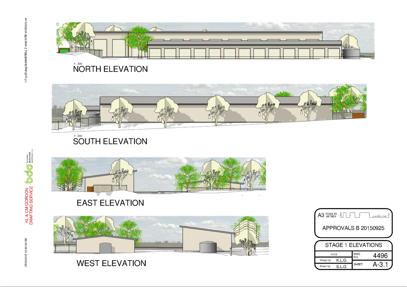
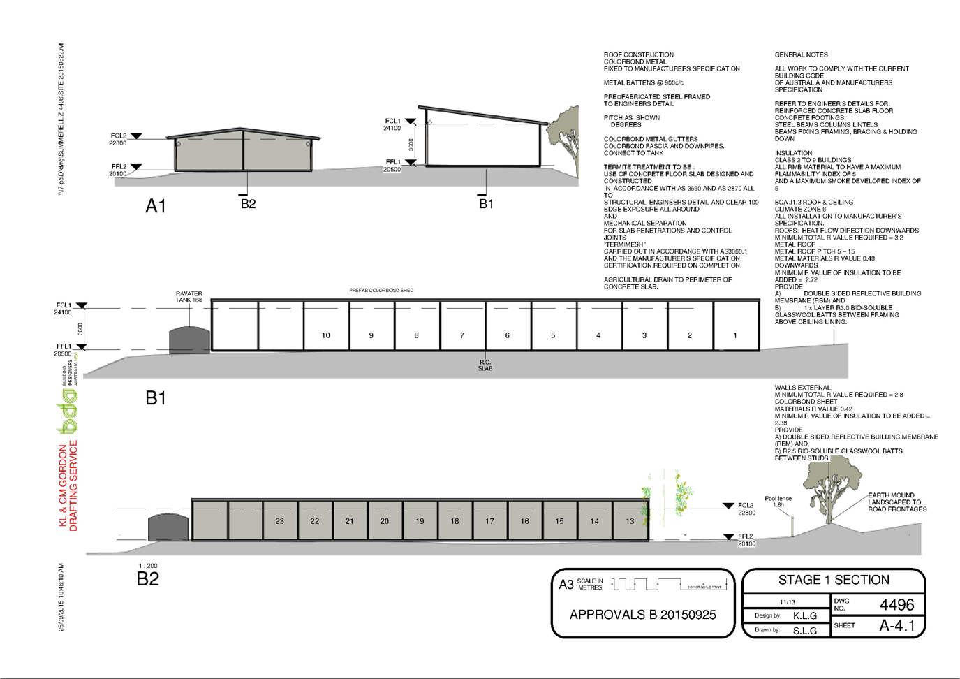
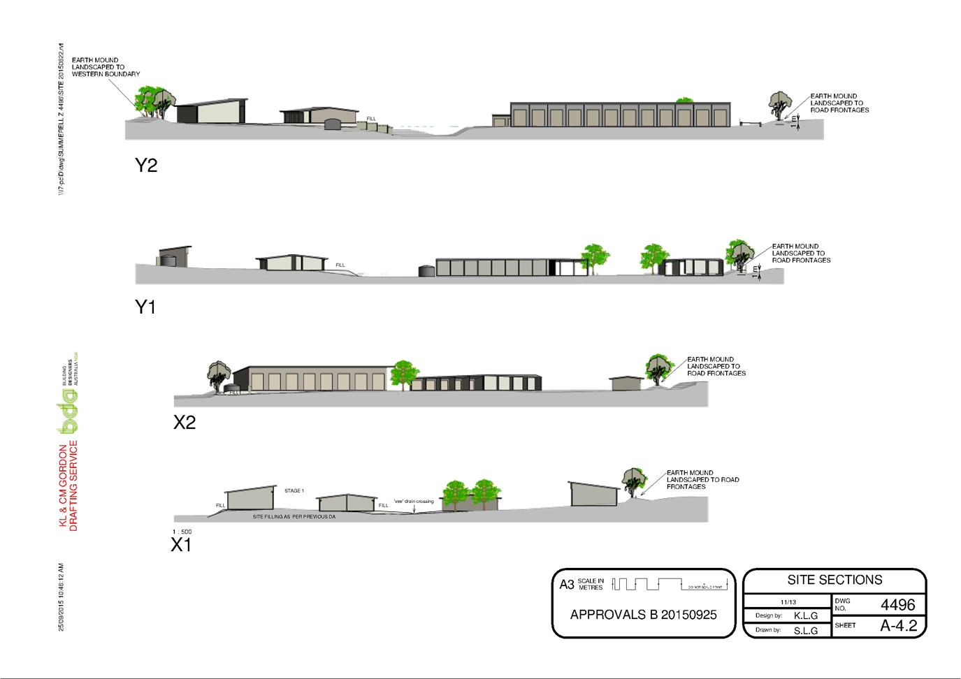
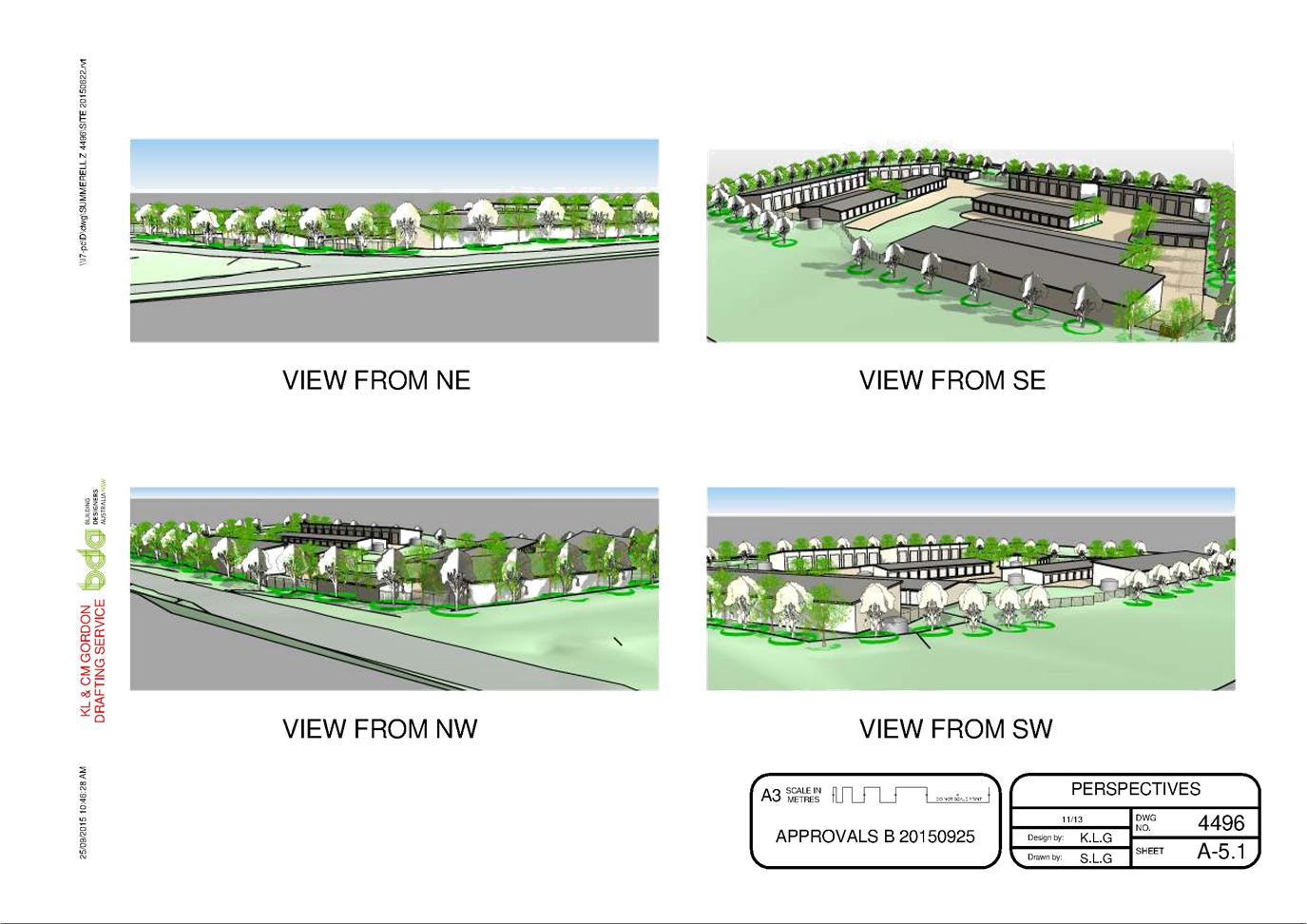
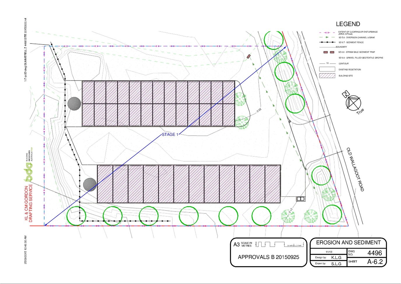

|
Council
|
14 October 2015
|
|
Item 8.5 - Attachment 2
|
Draft Consent Conditions
|
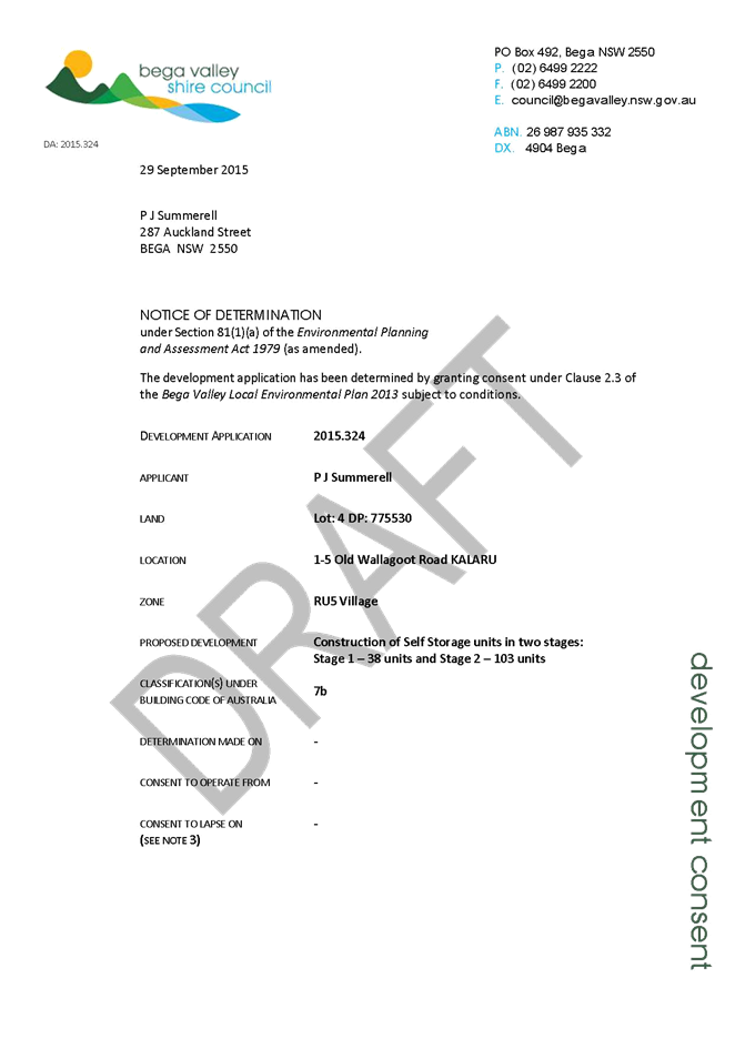
|
Council 14
October 2015
|
Item 8.6
|
8.6. Draft
Voluntary Planning Agreement Variation Deed - Service Road, Merimbula
The purpose of this report is
to advise of the outcome of the exhibition period for the draft Voluntary
Planning Agreement Variation Deed (draft VPA Variation Deed) and to recommend
the Execution of this Deed.
Group Manager Planning and Environment
Background
Council at its meeting of 10 June 2015 considered a
staff report on the proposed Voluntary Planning Agreement for the Merimbula
Service road and resolved the following:
“1. That Council
formally enter into the Voluntary Planning Agreement as attached to the report
for the construction of the Merimbula Service Road subject to the separate
execution of a Variation Deed by Merimbula Nominees and Merimbula Imlay Bowling
Club, both documents to be signed simultaneously.
2. That Council
note the supplementary legal information received and that the draft VPA
Variation Deed be exhibited for public comment for 28 days and that a further
report be prepared on any submissions received prior to execution of the
Variation Deed by Council.
3. That Council
formally enter into the Soil Nail Agreement for the temporary construction of
retaining wall support under the old Merimbula Library.
4. That the
Mayor and General Manager be authorised to execute the Voluntary Planning
Agreement and Soil Nail Agreement.
5. That the
Minister for Planning be advised that the Voluntary Planning Agreement has been
entered into by all parties.”
Point 2 of the resolution required the public
exhibition of the draft VPA Variation Deed and this report outlines the outcome
of the exhibition period.
Outcomes of Public Exhibition
The draft
VPA Variation Deed was placed on public exhibition in accordance with the
provision of the Environmental Planning and Assessment Act 1979 with no
submissions received.
Conclusion
In
accordance with the Council’s resolution of 10 June 2015, the draft VPA
Variation Deed was placed on public exhibition with no submissions received.
Accordingly
the Deed is now able to be executed by Council.
Attachments
Nil
|
Recommendation
1. That
the Mayor and General Manager be authorised to execute the draft Voluntary
Planning Agreement Variation Deed.
2. That
the Minister for Planning be advised of the variation to the Voluntary
Planning Agreement.
|
|
Council 14 October 2015
|
Item 8.7
|
8.7. DA No.
2014.346: Establishment of Weekly Markets for up to 40 stallholders - Littleton
Gardens, Bega
General Manager
|
Applicant
|
Sapphire Coast Producers Association
|
|
Owner
|
Bega Valley Shire Council
|
|
Site
|
Lot 104 DP 1151462, Part Lots 10-13 DP 758076, Littleton
Gardens, Bega
|
|
Proposed development
|
Weekly Farmers Market – maximum 40 stalls
|
Precis
In accordance with the
resolution of the Council meeting of 12 August 2015, attached to this report is
a draft consent for Council’s consideration.
The draft consent has been
prepared having regard to the matters for consideration under Section 79C of
the Environmental Planning and Assessment Act 1979.
Also included in this report is
the additional information required as part of the Council resolution.
The application is presented
for Council determination.
Background
A staff report
was submitted to the Council meeting held on 12 August 2015 with the following
recommendations:
“That Development Application No. 2014.346 being
for a weekly market (40 stalls) at Lot 104 DP 1151462, Part Lots 10-13 DP
758076, Littleton Gardens, Bega be refused for the following reasons:
a. The
proposal would result in an unacceptable impact on the surface of the land and
is not a compatible land use.
b. The
proposal would limit the opportunity for the land to be used for public
recreation.
c. The proposal
would have an adverse economic impact on the existing retailers within the Bega
Central Business District.”
Council
resolved as follows:
“1. That in keeping with
Council’s Code of Meeting Practice the matter be deferred for further
report to Council, with the report to include information on the number and
type of stalls, the location and number of days for markets to be held, so as
to be able to consider options for approval of the Development Application.
2. That the further report
to Council include draft conditions of consent, including conditions as to
parking.”
Description of the proposal
The application seeks approval for a farmers market to
operate one day per week with a maximum of 40 stalls.
In support of the proposal the applicant submitted the
following:
“The
SCPA Markets have been in operation in Littleton Gardens in Bega for over 12
years. They were set up to provide an outlet for the sale of locally grown/made
produce/products direct from producer to consumer. This is still the express purpose
of the Markets. SCPA considers this outlet to be of vital importance to the
community, as it is a unique opportunity for local people to sell fresh,
locally grown produce or locally made crafts.
“The
current definition of ‘local’ is 250km from Bega, as specified in
the SCPA Market Policy and Rules (attached). SCPA is in the process of revising
the Market Policy and Rules to further tighten up the definition of
‘local’ to produce/products from specific Shires (less than 250km
from Bega).
“The
markets provide a unique opportunity for local producers and craftspeople to
sell their products directly to consumers. This supports the local economy, as
well as significantly reducing the environmental and social impacts associated
with food production, ie, it reduces food miles, and it provides fresher, more
nutritious produce to local people. A survey conducted by TAFE students this
year has indicated that most people come to the SCPA Markets to buy fresh,
locally grown fruit and vegetables. The markets attract people who are looking
for a particular kind of product (“local”, “organic”,
“chemical-free”), not available at most retail outlets in town, so
the markets continue to provide a unique outlet for these goods.”
It is proposed that the market would operate between the
hours of 8.00am till 1.00pm every Friday, except Public Holidays.
Description of the site
It is
proposed that the market would continue to operate from the grassed area of
Littleton Gardens as identified on the map in Attachment 1.
Additional Information in response to Council’s Resolution
A letter was
forwarded to the President of SCPA on 14 August 2015 advising of the Council
resolution and requesting additional information in respect to following:
· number
and type of existing stallholders including goods offered for sale;
· type
of additional stallholders expected to increase the number of stallholders to a
maximum of 40;
· management
regime for wet weather;
· eligibility
rules for membership of SCPA;
· whether
SCPA would consider an option for a weekly market on days other than a Friday.
A detailed response has been received and
is included as Attachment 2 to this report for Council consideration.
Conclusion
In
accordance with the Council resolution of 12 August 2015 the report includes the
additional information requested and also a draft consent.
Council
previously considered a staff report which recommended refusal of the
application and this remains the staff position.
It is
recommended that Councils determine the application.
Attachments
1. Littleton
Gardens proposed layout plan with 40 market stalls
2. Additional
Information from SCPA
3. Draft
Consent
Recommendation
1. That
Development Application No. 2014.346 for a weekly market maximum 40
stallholders at Zingel Place, Bega be determined.
2. That
those persons who made a submission be advised of Council’s decision.
|
|
Council
|
14 October 2015
|
|
Item 8.7 - Attachment 1
|
Littleton Gardens proposed layout plan with 40 market stalls
|
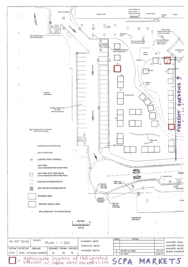
|
Council
|
14 October 2015
|
|
Item 8.7 - Attachment 2
|
Additional Information from SCPA
|
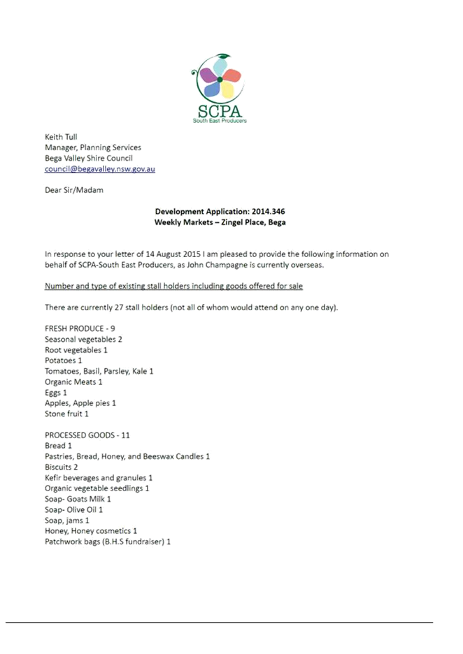


|
Council
|
14 October 2015
|
|
Item 8.7 - Attachment 3
|
Draft Consent
|
Staff Reports – Community, Culture and Leisure (Liveability)
14 October 2015
In accordance with
Council’s Code of Meeting Practice (2011), this section of the agenda
will be chaired by Cr Tapscott.
9.1 NSW
Public Libraries Conference 2015............................................................ 126
9.2 RFT59/15
Construction of Timber Footbridges and Gravel Pathways, Lake Curalo, Eden 128
9.3 RFT
64/15 - Conversion of building to library facility at Tura Beach............... 131
|
Council 14 October 2015
|
Item 9.1
|
9.1. NSW Public
Libraries Conference 2015
Councillor and staff participation
at the 2015 Public Libraries NSW Annual Conference and Annual General Meeting
is an important opportunity for Council to be involved in and keep up to date
with current issues facing NSW Public Libraries.
Group Manager Community, Relations and
Leisure
Background
Each year, the NSW Public Libraries Association (NSWPLA)
holds an Annual Conference at which the Association’s Annual General
Meeting is also held. It is an opportunity to meet with State Library of NSW
representatives and other library services. Council has supported the
attendance of a Councillor Representative in the past and hosted the event in
2007.
In 2015 NSWPLA will present its annual SWITCH Conference
from 17-19 November 2015 at the Australian Technology Park, Sydney. The theme
for this year is Sustain + ability.
The Conference will examine the many facets of
sustainability in libraries:
· Sustainable or
green buildings;
· Sustainable
programs and services;
· Sustainable
staffing; and
· Financial
sustainability.
More information is available at the Public Libraries
website http://nswpla.org.au/switch2015/
The Councillor delegate for NSW Public Libraries is Cr
Mahwinney approval is being sought for Cr Mahwinney or another Councillor
delegate to attend the conference with staff. Councillor representation is
important and many Councils send representatives.
Issues
Social
/ Cultural
Libraries play a significant role in providing access to
information for the community. Over time libraries have and continue to evolve,
to provide a range of functions including internet access, on-line and digital
media, work spaces, training and education sessions, activities for children
and young people, historical records management and many other activities.
Attendance at conferences such as this allows greater links for local libraries
to State, National and International developments and good practice/innovation.
Strategic
Continued development of the library service and staff
through attendance at conferences and other training is supported by
Council’s Library Services Strategic Plan
Financial
Costs
associated with the Conference are: registration $530; plus 3 nights’
accommodation, breakfast; travel costs; and incidental expenses. Council’s
budget for expenses incurred by Councillors acting as a Delegate for Bega
Valley Shire Council when outside the Shire is available to cover these types
of events.
|
Funding source
|
|
Amount
|
|
Delegates Expenses
|
$
|
2,000
|
Resources
(including staff)
Staff participation is covered within existing budgets.
Operational
Plan
Outcome
L2.2: Strengthen Bega Valley Library Service as a centre for life-long
learning.
Conclusion
This is a
valuable opportunity for Council to be involved in current issues relating to
library practice in NSW. Libraries are evolving and it is important for the
Bega Valley Shire Library Service stay ahead of these changes and look for ways
build sustainability into the services we deliver for the community.
Attachments
Nil
|
Recommendation
That Cr (name to be inserted) attend the 2015 Public
Libraries NSW Conference/AGM in conjunction with relevant officers and the
necessary expenses are defrayed by the Council in keeping with its policy.
|
|
Council 14 October 2015
|
Item 9.2
|
9.2. RFT59/15
Construction of Timber Footbridges and Gravel Pathways, Lake Curalo, Eden
This report presents a
summary of the procurement process and recommendations for awarding contracts
for the completion of the shared pathway around Lake Curalo, Eden.
Group Manager Community, Relations and
Leisure
Background
A pathway around Lake Curalo, Eden was identified in
the 2007 Eden Foreshores Plan of Management and more recently has been
enthusiastically supported by the community. Recent works have included
construction of gravel paths around the northern section in 2012 and a further
section in 2013.
The final sections of the pathway to be completed
include four (4) footbridge structures totalling 110 linear metres and around
600m of gravel pathway. This section of path has also required
acquisition of an easement over a section of private land.
Completion of these works will provide a continuous
link from central Eden to the Eden Cove development. The path also forms
a part of the Bundian Way, a culturally significant Aboriginal pathway linking
the Australian Alps to the coast. The completed pathway will be a great
asset for the Eden community and visitors alike to use and enjoy.
The works were put to public open tender on 26 August
2015 and closed on 23 September 2015. Tender documents were viewed on line 168
times and 8 formal proposals to deliver the works were received. Tender
assessment scoring was completed based on the following weighted criteria;
Tender Value: 50%, Experience 25%, Functionality 20%, Local Community Benefit
5%.
Issues
Legal
Council has previously resolved to acquire an easement for
the pathway across a section of privately owned land. The easement and
accompanying deed identify responsibilities, including installation of signage
and gates.
Environmental
Environmental issues are addressed by mitigation measures
recommended by NGH Environmental P/L in their Review of Environmental Factors
(REF) report.
When completed, the path will provide formalised accessible
trails through the lake-side foreshore and wetland areas.
Sustainability
The project will be constructed to achieve sustainability
goals outlined in the REF report.
Asset
The completed pathway will be a new asset and will be added
to Council’s Recreation Asset Management Plan when next updated.
Social
/ Cultural
The recreational linking of Eden township and the Eden Cove
communities is a social benefit of the project. The contribution to the
Bundian Way will provide a significant aspect of this culturally significant project.
Strategic
Completion of the pathway fits with the strategic plan for
the Eden area identified in the Eden Foreshores Plan of Management.
The delivery of this project was identified as a
Recreational Services project in the Bega Valley Shire Council (BVSC) Delivery
and Operational Plan 2014/15.
Consultation
The community was consulted as part of the original 2007
Eden Foreshores Plan of Management preparation. A community information
session was also held in April 2015, which provided strong, supportive feedback
for completion of the pathway.
Financial
Based on tender responses, total project costs are expected
to be no more than $410,000. Whilst the project tendering has come back
above the initial project estimate of $248,000, Council is committed to
delivering this project.
Detailed costings for the works are included in the
Confidential Memo attached. This includes breakdown of costs between the two
elements of the works being gravel pathways and bridges construction.
The funding shortfall is able to be met through savings
which have been achieved in other recently completed Leisure & Recreation
projects. The project costs will be funded within the current Leisure
& Recreation budgets.
To enable works to progress as quickly as possible, gravel
pathway construction works which fall within staff financial delegations, have
been awarded to the preferred contractor.
|
Funding source
|
|
Amount
|
|
Leisure and Recreation
Projected Capital Works Program
|
$
|
410,000
|
Resources
(including staff)
The works shall be undertaken by external contractors.
Project management and responsibility for delivery will be undertaken by
Council staff.
Operational
Plan
Outcome A2.3 – Safe and well maintained built
facilities meet the cultural, recreational, tourism and community service needs
of all ages and abilities in our community.
Conclusion
A pathway around Lake Curalo, Eden was identified in
the 2007 Eden Foreshores Plan of Management and more recently has been
enthusiastically supported by the community. Public tenders have recently
closed to complete the final section of pathway. Completion of these
works will provide a continuous link from central Eden to the Eden Cove
development.
The Confidential Memorandum to Councillors outlining the
tender assessment and review process makes recommendations for awarding
contracts to complete the works.
Attachments
1. Memorandum
Tender Assessment RFT 59 15 Construction of timber footbridges & gravel
pathways Lake Curalo Eden (Councillor Only) (Confidential)
|
Recommendation
1. That
the report be received and noted and the recommendation from the confidential
memorandum be accepted.
2. That
pursuant to Clause 178 (1)(b), of the Local Government (General) Regulation
2005 (Acceptance of Tenders) Council declines to accept tenders in relation
to works described in schedule A (bridges) of
tender RFT59/15.
3. That
pursuant to Clause 178 (3)(e), of the Local Government (General) Regulation
2005 (Acceptance of Tenders), Council enter into negotiations with <insert
name> for the construction of bridge works as described in schedule A of
tender RFT59/15.
4. That
pursuant to Clause 178 (4), of the Local Government (General) Regulation 2005
(Acceptance of Tenders) the reasons for declining to invite fresh tenders
are:
a) <insert name> demonstrated to have the
skills and resources to undertake the bridge construction.
b) Calling fresh tenders would unreasonably delay
the commencement of works.
5. That
Council authorise the General Manager through officers to negotiate with <insert
name> to a fair value for the bridge works component of the project and
execute all necessary documentation.
6. That
Councillors be notified of the outcome of the negotiations when finalised.
7. That
tenderers be advised of Council’s decision.
|
|
Council 14 October 2015
|
Item 9.3
|
9.3. RFT 64/15 -
Conversion of building to library facility at Tura Beach
This report details the
outcomes of evaluation of tender RFT 64/15 for building conversion, renovation
and fit-out of the old Tura Beach Tavern into a library and community facility.
General Manager
Background
In 2013 Bega Valley Shire Council purchased the Tura Beach
Tavern at Tura Beach with a view of converting the building into a library,
community spaces and exhibition areas replacing the Merimbula Library, which
has been operating from leased premises until its recent closure. Council’s resolution at the time
provided officers with the authority to obtain appropriate development
approvals for the uses of the property adopted by Council.
Since then, Council has
consulted with the community on possible uses. The use of the site as a library
and community spaces were seen as the priorities, with the exhibition space
being seen as the role of the Bega Valley Regional Gallery in Bega, notwithstanding
the potential to provide some exhibition space at the facility.
Library facilities are no
longer just book repositories, but places where people meet and interact,
access a range of physical, digital and on-line resources, learn new skills and
participate in activities such as story time, guest speakers, genealogical and
historical activities, or simply read. As such, modern library buildings are
more than just bricks and mortar and four walls, they are high tech places that
cater for all the aforementioned activities.
The Tura Beach Tavern requires
extensive renovation in order to convert the building from its previous use as
a licensed Tavern into a library. The detailed design of the Library
requires the demolition and rebuild of significant internal elements of the
existing building to accommodate access, public meeting space, toilet
facilities upgrades, electrical upgrades and library infrastructure.
There is also significant external works to provide a street frontage,
accessible paths of travel and a facade appropriate to a public building such
as a library.
An architect specialising in
library design was engaged to prepare detailed design, specification and tender
documentation as well Development Application and Construction Certificate
documentation. DA consent was provided on 1 May 2015 and CC issued on the 15
September 2015. The delay between the DA consent and the CC being issued was
due to a range of factors including staff changes at Council, delivery of
required supporting documentation from technical consultants, design discussion
with the architect and resolution of consent issues.
Tender RFT 64/15 Tura Beach
library was advertised in the Sydney Morning Herald, the Council website and
Tender link (e-tendering) with the tender closing on 30 September 2015. All
potential tenders are required to access the documentation through Tender Link.
Thirty companies downloaded the documents, with only two (2) formal submissions
being received as follows:
· Edwards
Construction Pty Ltd; and
· Rankin
Builders Pty Ltd.
The tenders were evaluated in
accordance with the evaluation criteria, weighting and scoring criteria as
follows:
· Project
Value, 65% made up as follows;
o The
overall project cost
o The
makeup of the cost structure
o The
integrity and the stability of cost
o Commercial
terms and conditions
· Project
experience, 20% made up as follows;
o Demonstrated
ability to complete the work
o Experience
in completing similar projects
o Quality
system and QA Experience
o Financial
ability to undertake project of this size.
· Project
functionality, 10% made up as follows; and
o Satisfaction
and recognition of the project objectives
o Conceptual
and operational plans
o Proposed
construction arrangements and completion program
· Local
community benefit, 5% made up as follows.
o Recognition
of local outcomes, demonstrating support for local business and community
enterprise.
The value of the tenders
received exceeds the current budget allocation for the project. The evalaution
of the tenders received is attached in a confidential memo to Cocunillors.
Issues
Legal
The project has received
Development Application consent and a Construction Certificate.
The tender process complied with
the Local Government Act 1993 and associated Regulations.
Policy
Council adopted a Library Strategic Plan in early 2015 to
drive the redevelopment and evolution of library services in the Shire over the
next three years. One element of that strategic plan (available on
Council’s website) is the transition to a new library in Tura Beach and
the closure of Merimbula Library.
Asset
Tura Beach Library will form part
of Council’s building asset register as a building owned and maintained
by Bega Valley Shire Council.
Social
/ Cultural
The following extract is taken from Council’s external
review of the Bega Valley Library Service report:
“In order to remain
relevant and provide valued community services, libraries and the services they
provide must continue to evolve and adapt to changes in the communities they
service. The last decade has seen many fundamental shifts in the library sector
and there is a significant risk that unless libraries adapt to these changes
they will no longer be relevant.
All local governments are
continually faced with an almost infinite demand for support and finite
resources. They must decide how best to allocate the available funds to
maximise community benefit. Libraries need to adapt to changing demographics
and provide adequate space and appropriate facilities for all age groups to
access quality services. It has been recognised that the population of
Australia is ageing with people in the over 65 years age group remaining strong
users of libraries and active borrowers of books. At the other end of the
age scale, young people who were ‘born digital’ have distinct
information and communication needs. These ‘digital natives’ access
information, learn and communicate in ways that older generations generally do
not. As opposed to reading books and magazines, digital natives prefer to draw
on and create information via the Internet, communicating using blogs, social
networking sites, SMS and web chat and participating in virtual worlds. To
attract these young people libraries will need to be inviting, offer the latest
in technology and new media and be accessible around the clock.”
Strategic
The development of a library and community spaces in the
Tura Beach area provides for a much needed community facility. The
population is growing in this area and demographics have been changing over
recent time with more young families moving into the area. The sites proximity
to an aged care facility, shopping centre and retails outlets ideally positions
the facility to be integrated into places people already frequent. A bus stop
on the Tura Beach Rd just up from the main entrance provides public transport
access and the entrance will be highly visible from the Tura Beach Rd.
In recognition of feedback from people who live in
Merimbula, Council has been working towards the setting up of a Library Portal
(a small library service) at the recently acquired former Auswide Services
building. The Portal will offer drop off and pick up services for borrowing,
study areas, photocopying, newspapers and some periodicals and public access
computers.
Consultation
Consultation has occurred on a number of occasions.
Following purchase of the Tavern site, Council sought feedback from the
community on the types of uses for the facility. As part of the DA process the
plans were put on display for four (4) weeks to ensure that people had an
opportunity to view and comment on the plans. No submissions were received that
impacted on the DA being issued. Officers have also spoken with the managers of
the Tura beach Shopping Centre regarding their thoughts and ideas about the
project.
Financial
Council had identified funds for this project consisting of
$200k from a NSW State Library capital grant and $300k from the sale of gaming
machine licences previously held by the Tura Beach Tavern and purchased as part
of the original sale.
The scope of works has been focussed on upper floor of the
Tavern and despite Officers best endeavours to contain the design and focus on
delivering a good, but responsible design, the costs have come back from both
tenderers in excess of available funds. The specific details and assessment of
the tenders is outlined in the confidential memo to Councillors.
The funding for this project
(excl GST) is as follows:
|
Funding
source
|
|
Amount
|
|
BVSC
|
$
|
500,000
|
Resources
(including staff)
This project has, since its inception, utilised a
significant amount of officer time to work through the many issues and
complexities of converting a commercial Tavern building into a community
building.
The library will be staffed by existing Customer & Information
Officers and operational costs are covered with the allocated library budgets.
Further Officer time will be required to oversee the works and ultimately the
commissioning of the building.
The building will be included in Council’s Asset
Management Plan and the maintenance and renewal will be built into
Council’s long term financial planning.
Operational
Plan
Outcome L2.2 - Strengthen Bega Valley library service as a
centre for life-long learning.
Conclusion
The building works to convert a
Tavern into a library require reuse of mechanical, electrical, hydraulic and
fire protection services and substantial modification of internal building
elements (walls, ceiling, doors and windows) all of which present a
construction cost risk and it is assumed this has been reflected in tenderer
prices received. While both tenders are comprehensive and the builders
experienced and capable they are well beyond Council’s funded budget and
therefore will require further consideration and resolution on the way forward.
Attachments
1. Memo
to Councillors - RFT - Tura Library (Councillor Only) (Confidential)
|
Recommendation
1. That
Council receive and note the report;
2. That
Council confirm its intention to relocate the Merimbula Library service to
the facility at Tura Beach;
3. That
Council accepts recommendations as outlined in the confidential attachment.
4. That
Council declines to accept any tenders in relation to contract for works as
described in RFT64/15 as no tender received fully complied with the requirements
of the tender documents nor offered acceptable value for this project.
5. That
Council not invite fresh tenders as this would unlikely yield a better result
given the uncertainties and construction risk associated with this project.
6. That
Council enter into negotiations with <insert> to undertake the
conversion works for the new Library at Tura Beach, as this will provide
Council with the most direct and cost effective project delivery.
7. That
tenderers be advised of Council’s decision.
|
Staff Reports – Infrastructure Waste And Water(Accessibility)
14 October 2015
In accordance with Council’s Code of Meeting
Practice (2011), this section of the agenda will be chaired by Cr Fitzpatrick.
11.1 Formalisation
of road name: Virginia Drive, Bega ....................................... 138
11.2 Formalisation
of road name: Robin Close, Merimbula.................................... 141
11.3 Off-road
bike path options for Tathra to Kalaru and Kalaru to Bega............... 144
11.4 Request
by Bermagui Mens Shed for long term lease of old Bermagui landfill site. 146
11.5 Water
Trunk Mains Cleaning Services ............................................................. 150
|
Council 14 October 2015
|
Item 11.1
|
11.1. Formalisation of road name: Virginia Drive,
Bega
Following development of the
new Regional Hospital and creation of a new public access road from the
roundabout on Tathra Road Bega, Council is required to formally name this section of road
that is adjoining the development.
Group Manager Transport and Utilities
Background
The unnamed road is the main access route to the new
hospital site, adjoining the roundabout on Tathra Road. This road has
been dedicated to Council and upon official completion and hand over of the
development Council will take over maintenance of the road. While Council does
have available pre-approved street names, the Southern NSW Local Health
District have requested that the name Virginia Drive be approved.
The name complies with Council's Road Naming Policy
under Bega Valley Shire Council Procedure 2.2.1(b) – Road Naming criteria
under section (iii) as follows:
(iii) Either full names or
surnames may be used for roads as appropriate names that acknowledge eminent
persons within the locality or historical property in the area or of an
historical background. Such names may include long term property owners, early
explorers, settlers or persons who have excelled in some community oriented or
other activity.
Virginia Miller has a close association with Bega Hospital,
having worked as a radiographer at the hospital from 1987 until shortly before
her death in 2009. She was well respected by staff for her professional
work, being the person medical students were told to emulate. She was
well known and loved by staff and the community. Further, Virginia has a
close connection with the new hospital site, as it was owned by the Miller
family prior to the development of the new hospital. The land for the new
hospital was previously owned by a Miller family company.
The Geographical Names Board (GNB), Surveyor General (SG)
and Registrar General (RG) have reviewed the name under GNB Guidelines for the
Naming of Roads and there is no objection to its use.
Issues
Consultation
The proposed road name of Virginia Drive will be advertised
in local newspapers, calling for objections and allowing a period of twenty
eight days for submissions to be received. If no objections are received
the Geographical Names Board will be advised to arrange gazettal.
Financial
Advertising costs have been
provided for in the current budget.
Resources
(including staff)
Council property staff will
be required to complete the public notification process.
Conclusion
Formalisation of the road
name is in accordance with Council’s road naming procedure and it is
recommended the public notification process now commence to formally name the
road Virginia Drive.
Attachments
1. Location
map for proposed Virginia Drive, Bega
|
Recommendation
1. That
Council approve the proposal to name the unnamed road located adjacent
to the new hospital site and adjoining Tathra
Road Bega, at the roundabout as Virginia Drive.
2. That
Council advertise the proposed name in the local media inviting submissions
to the proposal.
3. That
if no objections are received within the submission period, staff proceeds
with the road naming proposal without subsequent referral to Council.
|
|
Council
|
14 October 2015
|
|
Item 11.1 - Attachment 1
|
Location map for proposed Virginia Drive, Bega
|
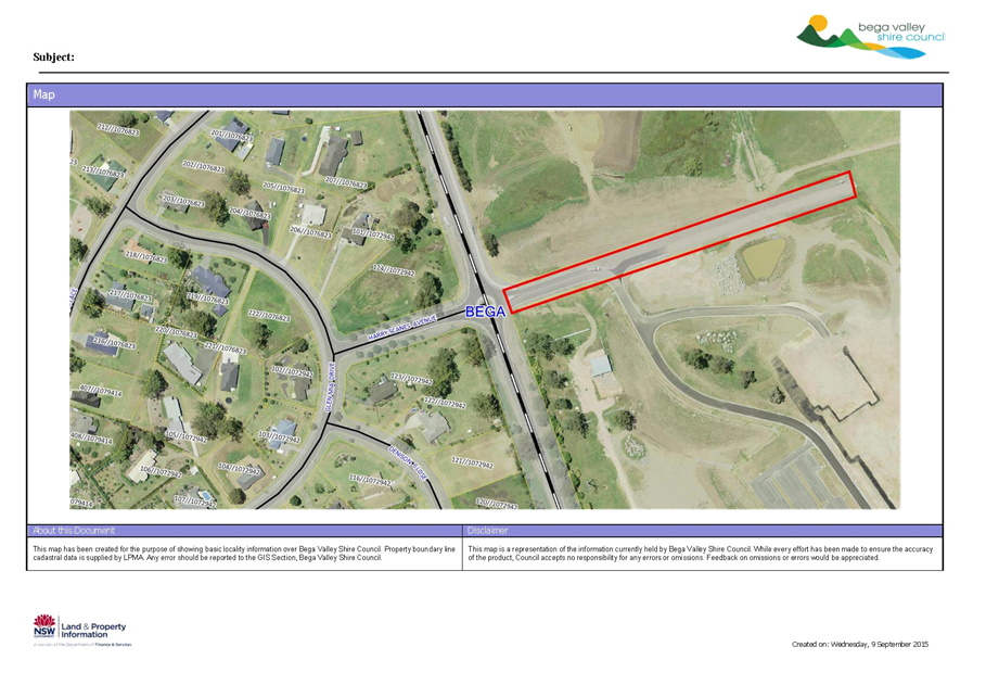
|
Council 14
October 2015
|
Item 11.2
|
11.2. Formalisation
of road name: Robin Close, Merimbula
A development application
(DA) has been approved for a new subdivision in Merimbula and Council has
received a request from the developer to formally name the new road associated
with the subdivision, Robin Close.
Group Manager Transport and Utilities
Background
The unnamed road will serve as an access road to the
subdivided land parcel adjoining Lakewood Drive, Merimbula. This road
will be dedicated to Council and upon registration of the subdivision plan,
Council will take over car and control of the road. Given Council’s
pre-approved street names list has been exhausted for the Merimbula area, the
name being proposed by the developer is Robin Close.
The name complies with Council's Road Naming Policy
under Bega Valley Shire Council Procedure 2.2.1(b) – Road Naming criteria
under section (vi) as follows:
(vi) Names that are part
of a common theme for road names in a locality.
Given that road names in this particular area are named
after fish, for example: Trevalley Terrace; Snapper Court; and Salmon Court and
there is a fish known as the common Sea Robin it is staff recommendation to
proceed with the use of Robin Close to name the new road.
The Geographical Names Board (GNB), Surveyor General (SG)
and Registrar General (RG) have reviewed the name under GNB Guidelines for the
Naming of Roads and there is no objection to its use.
Issues
Consultation
The proposed road name of Robin Close will be advertised in
local newspapers, allowing a period of twenty eight days for submissions to be
received. If no objections are received the Geographical Names Board will
be advised to arrange gazettal.
The Geographical Names Board, in consultation with Land
& Property Information and Council’s throughout NSW has recently
developed a NSW Address Policy. This policy was adopted in March 2015 and
Bega Valley Shire Council’s road naming procedure will need to be updated
to comply with the new policy and guidelines. Council’s existing
procedure also includes a list of pre-approved road names compiled almost 20
years ago. That list is almost exhausted and it is therefore proposed
that Council staff undertake a public consultation process to seek suggestions
from members of the community of names to be considered for road naming in the
future.
Rather than seeking the names of war service men and women
only (as was the process last time), it is suggested that the following
thematic categories may be appropriate:
· Local
Aboriginal heritage;
· Early
explorers, pioneers, settlers and historical figures;
· Natural environment, marine, flora or
fauna.
All names suggested by the public will be presented to
Council for approval and inclusion in a pre-approved road naming list.
Financial
The subdivision application
fee for a new road has been paid by the developer and includes a contribution
to the formal road naming process.
Resources
(including staff)
Council property staff will
be required to complete the public notification process.
Conclusion
Formalisation of the road
name is in accordance with Council’s road naming procedure and it is
therefore recommended that the public notification process now commence to
formally name the road Robin Close.
Attachments
1. Location
map for proposed Robin Close, Merimbula
|
Recommendation
1. That
Council approve the proposal to name the unnamed road located off
Lakewood Drive in Merimbula as Robin Close.
2. That
Council advertise the proposed name in the local media inviting submissions
to the proposal.
3. That
if no objections are received within the submission period, staff proceeds
with the road naming proposal without subsequent referral to Council.
4. That
authority be given for Council staff to commence a public consultation
process calling for new names to be used for future road naming throughout
the Shire, based on the following thematic categories:
· Local Aboriginal heritage;
· Early explorers, pioneers,
settlers and historical figures;
· Natural
environment, marine, flora or fauna.
With
all names suggested by the public to be presented to Council for approval and
inclusion in a pre-approved road naming list.
|
|
Council
|
14 October 2015
|
|
Item 11.2 - Attachment 1
|
Location map for proposed Robin Close, Merimbula
|
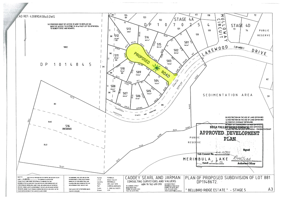
|
Council 14
October 2015
|
Item 11.3
|
11.3. Off-road bike
path options for Tathra to Kalaru and Kalaru to Bega.
Following a community
meeting, Council staff have been requested via petition to Council 23 September
2015 and Question on Notice by Cr Seckold meeting 23 September 2015, to explore
options for funding the Tathra to Kalaru and Kalaru to Bega off-road bike path,
as identified in the Bega Valley Bike Plan 2014.
Group Manager Transport and Utilities
Background
Community members from the Bega, Kalaru and Tathra areas
held a meeting on 17 September 2015, at the Council Chambers in Bega to discuss
the provision of a bike path connecting Tathra and Bega. The community has
generated support and interest through establishing a social media site called
Bega to Tathra Safe Ride, and creating an on-line petition (which has now
closed) supporting a safe ride opportunity between Tathra and Bega.
Council staff attended the meeting predominantly to answer
questions generated from the group. Cr Liz Seckold chaired the meeting and was
asked to put forward a question to the Council regarding funding options for
the construction of the path.
There were many options raised by people who attended the
meeting, such as a special rate variation or levy, use of voluntary labour and
community groups, utilisation of a green army, corporate sponsorship, grants,
etc. However, it was understood most options available would require some
length of time before the project was complete.
When exploring the options for a safe ride from Tathra to
Bega there are various issues, challenges/risks and opportunities which make
the project unique. The initial scoping and planning of the project is
crucial in identifying the opportunities and constraints within the project
area.
Council recently applied to the Roads and Maritime Services
under their Active Transport Program (Connecting Centres) for the 2016/17
financial year, for funds to assist Council. Under the program Council
can apply for up to 75% contribution towards project scoping and design.
Council has included in its grant proposal community consultation, site
scoping, feasibility and concept design for the Bega and Tathra, Tura Beach and
Merimbula and Bermagui and Wallaga Lake. The funds requested, were $120,000 of
a $160,000 estimated cost.
Issues
Legal
Depending on the preferred route there will most likely be
requirements for land acquisition/s. There are some land holders that
attended the community meeting who said most of the landholders between Bega
and Kalaru support the proposal and feel land acquisition would not be a major
hurdle. If the request for funding from the Roads and Maritime Services
(RMS) is successful, a complete design will be produced which will identify the
preferred route and also any requirements for land acquisition and associated
costs.
Sustainability
By creating options for active transport there are many
advantages to the community which include increased health benefits, social
benefits and economic outcomes. Cycling is also a much more sustainable
option than using motorised vehicles especially over short distances.
Asset
The end result of this long term project is the creation of
a safer alternative for cyclists to travel between Tathra and Bega. At this stage
it is anticipated this will be an off-road bike path built in stages, however
this is subject to the findings of the pending grant application and future
availability of ongoing resources.
Consultation
Consultation has commenced and is being generated by an
enthusiastic positive community group. Through the scoping and design
phase of the project is expected consultation will be comprehensive and engage
all affected sectors of the community.
Financial
In this early phase of the proposal, there are no definitive
costs for the construction of a safer alternative for cyclists between Tathra
and Bega. It is essential for Council to commit to the scoping and design
of the project for reliable and workable information. Through effective
consultation scoping and design, Council will have a final plan to cost against
and then work through a funding strategy once a final design has been produced
and signed off. The funding application is for the 2016/17 financial year.
|
Funding source 2016/17
|
|
Amount
|
|
RMS
|
$
|
120,000
|
|
Council
|
$
|
40,000
|
Conclusion
This is a project that has been discussed with varying
levels of intensity over the last 20 years or more. Council once notified
of the pending grant application will have an opportunity to focus on the
production of a final plan and design for the Tathra to Bega cycle routes as
well as others. This will then give Council, community groups and
interested parties a basis on which to formulate funding and/or resourcing
options.
The application to the RMS will also address similar issues
that have been raised in the Bermagui, Tura Beach and Merimbula areas, and are
consistent with one of the major principles of the Bike Plan by focusing on
connecting communities.
Attachments
Nil
|
Recommendation
1. That
Council note the funding grant application for the planning and design of a
cycle routes in Bermagui, Merimbula, Tathra and Bega.
2. That
Council consider a $40,000.00 matching contribution if the grant application
is successful, as part of its 2016/2017 budget considerations.
|
|
Council 14 October 2015
|
Item 11.4
|
11.4. Request by
Bermagui Mens Shed for long term lease of old Bermagui landfill site.
Bermagui Men’s Shed has
requested Council consider offering a lease over part of the old Bermagui
landfill site to establish a long term location for the group. This report
discusses some of the issues and seeks Council’s direction.
Group Manager Transport and Utilities
Background
The Men’s Shed is a not for profit,
non-commercial association aimed at reducing social isolation and improving
health by engaging men in meaningful projects they can work on in the company
of other men. The Bermagui Men’s Shed (BMS) currently operates from
leased premises at the Umbarra Cultural Centre at Wallaga Lake (Eurobodalla).
The lease is uncertain and the site is not ideal in terms of proximity and
access to Bermagui. The BMS has requested Council consider offering them a long
term lease over the north eastern part of land adjacent to the Bermagui Sewage
Treatment Plant and Works Depot, the area of land formerly used as the Bermagui
Landfill (Lot 287 DP 1151605).
The site is Crown land under Bega Valley Shire Council
(BVSC) management. The landfill operation was approved by the Department of
Health in 1962 and ceased operations in 1989 after which the landfill activity
was moved to its current location further south. Parts of the original site
have been redeveloped for the Bermagui works depot and treatment works. Areas
of the site are used by Council for stockpiling and storage of materials.
Solid waste landfill sites are problematic to
redevelop particularly for structures, as ground conditions are unpredictable
and there is high likelihood of the presence of contaminated materials,
particularly asbestos, with potential health concerns if disturbed. Beneficial
use is possible, provided there is careful consideration and management of
these risks during construction and for the duration of the land use.
Based on preliminary geotechnical investigation of the
site, the old landfill is understood to extend from the north east corner of
the site, increasing in depth to the southwest corner of the site. Accordingly,
it is believed the north east portion of the site presents the least likelihood
of excessive remediation costs as the landfill is thought to be present in a
thinner layer in this area when compared to other areas of the site.
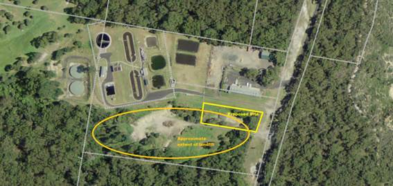
Figure: Area proposed for further
investigation with regard to geotechnical and environmental constraints.
As the project is currently at the early feasibility /
planning stage, no specific plans of the proposed development are available.
However, based on early discussion with BMS, it is understood their facilities
would comprise the following elements:
· Construction of a lightweight steel frame building
with a footprint of about 260 m2 (to include office space,
meeting room, kitchen facilities, workshop area(s) storage facilities and
washrooms;
· Sheltered outdoor communal area(s);
· A barbeque area;
· Car parking facilities for up to 30 vehicles.
The BMS would be similar in scale to the Council works
depot located to the north of the proposed site and shown in the photograph
above.
Issues
Legal
Council is the appointed Reserve Trust Manager of the old
Bermagui landfill site, known as the Edgar Jaggers Reserve (180062).
Council is authorised under the Crown Lands Act 1989 to enter into a
lease or licence agreement for the occupation of a Council managed reserve,
with the approval of the Minister for Lands.
Policy
If the proposal proceeds for the occupation of this site by
the Bermagui Men’s Shed, they would be required to submit an application
under Council’s Rental Assessment and Rebate Procedure. Being a
not-for-profit community organisation which provide a valuable social benefit
to the local community, it is likely there would be a high level of rebate off
market rental available.
Environmental
Substances of potential concern within the landfill that may
pose a potential risk to human health and/or the environment include:
· Heavy metals
primarily in relation to ash and metallic wastes;
· Petroleum
hydrocarbons associated with waste lubricants;
· Polycyclic
aromatic hydrocarbons (PAHs) associated with ash and demolition waste;
· Asbestos from
demolition waste; and
· Landfill gases
such as methane, carbon dioxide, carbon monoxide and hydrogen sulphide related
to decay of organic matter within the waste.
The main exposures include:
· Direct skin
contact with the effected soil;
· Hand to mouth
activities resulting in ingestion of soil;
· Airborne migration
of dust or soil particles leading to inhalation; and
· Volatilisation
leading to inhalation.
Further evaluation of the environmental risks is
warranted should Council wish to consider development of this site.
Sustainability
Beneficial use of closed landfill sites is a desirable
sustainability outcome and generally encouraged by the Environment Protection
Authority (EPA). However, it also poses some risk management and cost
considerations that would need to be weighed against the value of the proposed
development.
Asset
The site has significant potential asset value. At present
the site is a liability and provides no appreciable return to the community.
Realising the value of the asset will take significant investment, however
development of the site would demonstrate Council’s commitment to
sustainable development and the local community.
Social /
Cultural
The Men’s Shed Association is well regarded in the
community and provides a significant social benefit by providing men with the
opportunity to improve and maintain their health and well-being by
participating in the Men’s Shed program. There are now over 300
Men’s Sheds throughout New South Wales, with many located on Crown
reserves. Crown Lands have been a supporter of the Men’s Shed movement
and fully support Council’s endeavours to try and find a new location for
the Bermagui branch.
Financial
An evaluation of the capacity of the site to be developed
for public use would likely cost in the order of $50 to $100k. The mitigation
measures, which may include an engineered cap over part or all of the site,
and/or potentially removing some of the waste buried on site, would be a
significant capital project. However, until a detailed evaluation is undertaken
and a remediation plan is prepared, any estimate of the cost at this stage is
speculative.
Conclusion
Council’s direction is sought with regard to further
investigation of the Old Bermagui Landfill site with a view to remediation to a
standard such that it could be used for the development of a Men’s Shed.
Attachments
Nil
|
Recommendation
1. That
Council procure consultancy services to develop a remediation plan for a
portion of the old Bermagui Landfill site.
2. That
a further report be prepared for Council on the potential cost of remediation
works proposed.
3. That
Council write to the Bermagui Men’s Shed indicating a commitment to the
development of a remediation plan, with a decision on whether to proceed with
remediation based on an assessment of the likely cost of the works.
4. That
Council advise the Bermagui Men’s shed the likely timeframe for the
detailed investigation, consultancy report and decision on whether to proceed
will be of the order of 12 months.
|
|
Council 14 October 2015
|
Item 11.5
|
11.5. Water Trunk
Mains Cleaning Services
This report seeks Council
approval to engage contract services for cleaning of trunk water mains without
advertising through a public tender process.
Group Manager Transport and Utilities
Background
The Bega / Tathra water supply system has a history of
higher than normal customer complaints relating to dirty water incidents. The
dirty water is associated with high levels of iron and manganese in the source
water. The long term solution to the problem is construction of a treatment
plant at South Bega.
Water main flushing and air scouring have been the
traditional methods relied on to minimise the incidence of dirty water however,
their effectiveness with larger diameter trunk mains has been marginal and in
some instances poor.
A new technology known as “Ice Pigging” has
recently been introduced into Australia by Suez Pty Ltd and based on a
successful trial held in Bega in March 2015 it is proposed to clean all trunk
water mains between Bega bores and Tathra.
Issues
Legal
Council has a written quotation from Suez Pty Ltd in the
amount of $259,000 (excl. GST).
In accordance with Council Procedure 5.08.1, the General
Manager can approve expenditure up to $150,000 without the need for competitive
quotes provided that exceptional circumstances justify the exemption.
In this case, the exceptional circumstances relate to
unavailability of competitive quotes and the General Manager approval has been
received for up to $150,000 (incl. GST) of the work to secure Suez Pty Ltd
services prior to Christmas 2015.
The balance of the expenditure up to a total of $285,000
(incl. GST) can be approved by Council under the Local Government Act 1993
Section 55 Clause 3 Part (i) which states;
“a contract where, because of extenuating
circumstances, remoteness of locality or the unavailability of competitive or
reliable tenderers, a council decides by resolution (which states the reasons
for the decision) that a satisfactory result would not be achieved by inviting
tenders”
Policy
The procurement of Suez Pty Ltd service for “Ice
Pigging” is in accordance with Council policy and procedures.
Asset
The work is a necessary operational task required to enhance
the level of service to Bega / Tathra water supply customers.
Consultation
Some minor customer consultation/ information will be
required prior to works commencing.
Financial
The expenditure for the work will be drawn from 2015/16
water supply operations budget.
Resources
(including staff)
Minimal staff resources will be required during the ice
pigging work.
Operational
Plan
The work will help reduce customer complaints due to dirty
water and will have a positive impact on Operational Plan levels of service.
Conclusion
Ice pigging will enable effective cleaning of the large
trunk water mains between Bega bores and Tathra. The work will result in the
majority of sediment being removed from the mains and an improvement in
customer water quality.
Attachments
1. Memo
Leanne Barnes from Wayne Sartori Ice Pigging Approved
|
Recommendation
1. That
Suez Pty Ltd be directly awarded the trunk water main cleaning contract for
the part sum of $135,000 (incl. GST) to complement the $150,000 sum (incl.
GST) already approved under the General Manager delegation for a total
expenditure of $285,000 (incl. GST).
2. That
the contact be directly awarded on the basis that a competitive alternative
is unavailable as Suez Pty Ltd are the sole providers of “ice
pigging” technology in Australia.
|
|
Council
|
14 October 2015
|
|
Item 11.5 - Attachment 1
|
Memo Leanne Barnes from Wayne Sartori Ice Pigging Approved
|
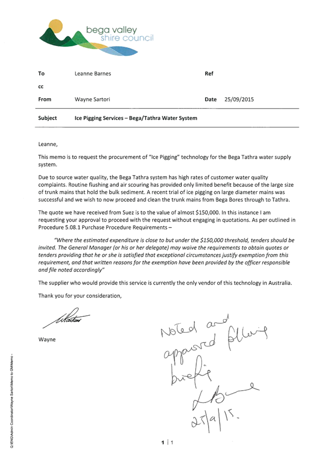
Staff Reports – Governance And Strategy (Leading
Organisation)
14 October 2015
In accordance with Council’s Code of Meeting
Practice (2011), this section of the agenda will be chaired by Cr Mawhinney.
12.1 Major
projects quarterly update....................................................................... 154
12.2 Actions
from resolutions of Council - Status Report......................................... 157
12.3 Internal
Audit Committee Yearly Review 2014/15........................................... 189
|
Council 14 October 2015
|
Item 12.1
|
12.1. Major projects quarterly update
Council resolved in December
2014 to receive quarterly reports on a number of major projects for the period
January to 30 June 2015. This fourth and final quarterly report outlines
updates against these key projects. The next report will focus on the 2015-16
major projects
General Manager
Background
At its meeting on 17 December 2014 Council resolved:
1. That Council adopts the major projects
for the period 1 January to 30 June 2015 as listed below:
Major Projects:
· Bega, Bermagui, Eden and Merimbula Town Centre designs
· Bega Civic Centre
· Eden Port development
· Littleton Gardens
· Merimbula Airport
· Merimbula Bypass
· Merimbula effluent management
· Merimbula lands development
· Tura Community Centre and Branch Library development
Key
organisation operational projects:
· Response to Fit for the Future, the NSW State
Government’s response to the independent review of Local Government
including the review of Council’s Resourcing Strategy, including
Council’s Asset Management Plans, Long Term Financial Plan and Workforce
Strategy
· Council’s Business Growth and Economic Development
Strategy implementation
· Council’s communications and community engagement
review
2. That into the future the
development of the annual Operational Plan includes a list of the top projects
to be reported on a quarterly basis to the Council and the community.
A monthly staff report is prepared on these and other
significant projects for appropriate monitoring and oversight from the senior
staff team. Key aspects reported against include:
· Planned outcomes and key outputs
· Progress with timelines and milestones
· Risks and actions to mitigate risks
· Internal and external communication plans
· Budget items including progress against budget
Councillors receive a confidential copy of these reports on
a regular basis.
The following table summarises the information relating to
the progress of the items which Council resolved to receive regular updates on.
The 2015-16 operational plan website is being finalised to
include a section devoted to these headline projects for the year which will be
reported against quarterly.
|
PROJECT
|
COMMENT
|
|
Town centre design projects – Bega, Bermagui,
Eden, Merimbula
|
Works progressing to program plan for the first project
which is Imlay Street Eden, with completion expected in November. Community
information sessions held weekly with traders.
|
|
Bega Civic Centre
|
Building handed over from construction company to
Council. Fit out for Chamber progressing. Management company appointed, fees
for new centre use on public exhibition. Naming for the centre resolved by
Council. External works and access commenced. Live streaming commissioned.
Official opening planned to coincide with Australia Day activities 2016.
|
|
Eden Port
|
Crown Lands progressing project as planned. Community
information session hosted by Council in Eden on 7 September was very well
attended.
|
|
Littleton Gardens
|
Public art commission by Jen Malleson to be installed
in late October. Construction works progressing. Car park access and northern
half of Zingel Place to be completed in October with remaining works to be
completed by December 2015. Issues relating to tree removal caused concern
with some in the local community and restriction of vehicular access and
parking during works has also been raised as an issue. Regular updates are
being provided by as many means as possible to keep the community updated on
works here and also in Gipps Street.
|
|
Merimbula Airport
|
Operational management tender process on track with
Probity Advisor appointed, independent assessment panel members appointed and
tender documents issued. On track to report to Council in November 2015.
Regional Tourism Infrastructure (Regional Airports)
program stage 2 application lodged.
Application for National Stronger Regions Fund Round 2
lodged.
|
|
Merimbula By Pass
|
Works on roundabout completed
Land acquisition matters finalised.
Park/Wonga Streets drainage construction to commence
October 2015. Palmer Lane (north) car park to be constructed as well as
temporary car park in Wonga Street. Adjacent residents and relevant
businesses contacted via letterbox drop and directly. Chamber advised of
works. Adjacent owners separately contacted regarding trees to be removed.
|
|
Merimbula effluent management
|
Process to engage EIS consultants progressing. Ocean
data collection continuing. Panel appointed. Minister’s staff advise
State significant application is supported, awaiting sign off.
|
|
Merimbula Lands development
|
Main Street property documents to place site out for
tender being prepared. Building assessment reports being undertaken as part
of the due diligence requirements.
Purchase of Auswide announced and closed session
reports released.
Matter has now settled. Planning proposal for the
site being prepared. Draft Business Plan will now be finalised to next stage
and reported to Council.
|
|
Tura Community Centre and branch library development
|
DA approved and construction certificate issued.
Tender for works closed and to be reported to Council
meeting 14 October 2015.
|
|
Fit for the Future (FFTF) and Resourcing Strategy
Review
|
IPART to provide recommendations on Council improvement
proposals to State Government mid October. State Government expected to
announce final position in December 2015. Joint organisations of councils
model now being further developed. Council submission on the Emerging
Directions paper submitted following Council meeting of 23 September. MOU with
Eurobodalla Council being progressed through a working party to be reported
to Council in December 2015.
|
|
Business Growth and Economic Development Strategy
implementation
|
Economic Development Strategy adopted. Staff position
appointed with new officer to commence duties in October 2015. Discussions
commenced re holding an economic development and business growth week of
activities.
|
|
Communication and community engagement review
|
Staff training sessions commenced with provider,
International Association for Public Participation Australia. Second round of
training to be held later this year with session also to be run for
Councillors.
Last meeting of community reference panel to be held in
October 2015.
|
Attachments
Nil
|
Recommendation
That Council note the fourth major projects update report.
|
|
Council 14 October 2015
|
Item 12.2
|
12.2. Actions from
resolutions of Council - Status Report
This report provides a status
update on staff actions from Council resolutions over the past four months.
General Manager
Background
In order to ensure the community and Councillors are kept
updated on the progress of implementation and actions from Council resolutions,
a formal quarterly reporting process is now in place. Currently Council
resolutions are recorded in a “minute Instruction”. Following each
Council meeting the resolutions are tasked to an officer in the Council’s
electronic Report System, InfoCouncil. The progress of actions
against resolution is monitored by senior staff and the minute instructions are
printed and made available at each Council meeting.
To improve transparency a process has been introduced so
that each quarter an update report is provided formally to Council noting
comments and actions against all Council resolutions. This report is the third
report under the new process. Prior to the end of the Council term a report
will be prepared outlining progress against all Council resolutions for the
Council term from October 2012 until September 2016.
Attached is the report for the period 1 July 2015 to 30
September 2015. This report provides information to Councillors and the
community on the status of those actions taken on Resolutions over the past
three months. The report on actions will also be available on Council’s
website.
Conclusion
Councillors and members of the community are interested in
the progress of actions against Council resolutions. This process provides a
formal report back to Council on a quarterly basis and then provides the
information openly to the community via Council’s website.
Attachments
1. Completed
Council Meeting Actions 1 July 2015 to 30 September 2015
2. Outstanding
Council meetings actions 1 July 2015 to 30 September 2015
|
Recommendation
That Council note the status report on actions from
Council’s resolutions for the period 1 July 2015 to 30 September 2015
|
|
Council
|
14 October 2015
|
|
Item 12.2 - Attachment 1
|
Completed Council Meeting Actions 1 July 2015 to 30 September
2015
|
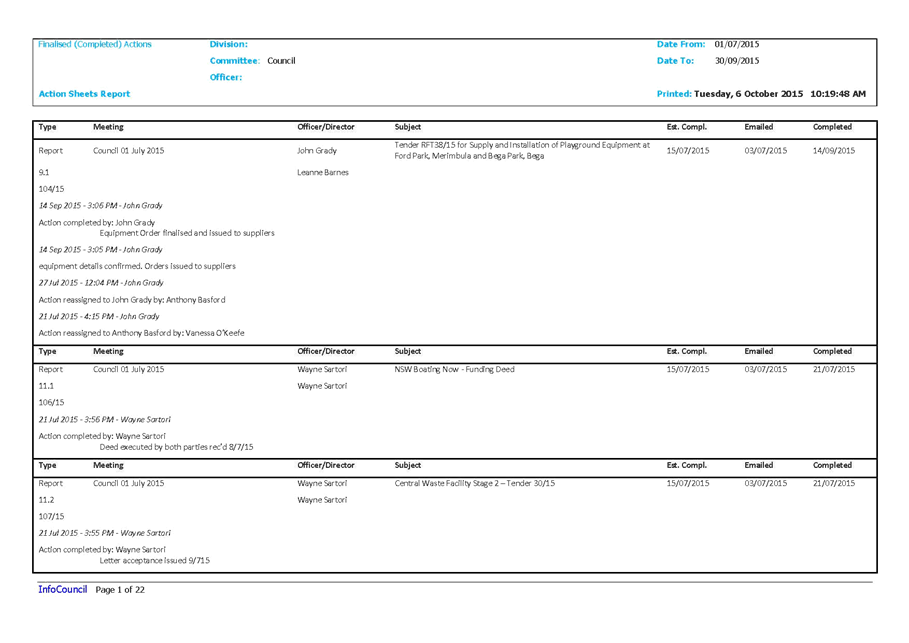
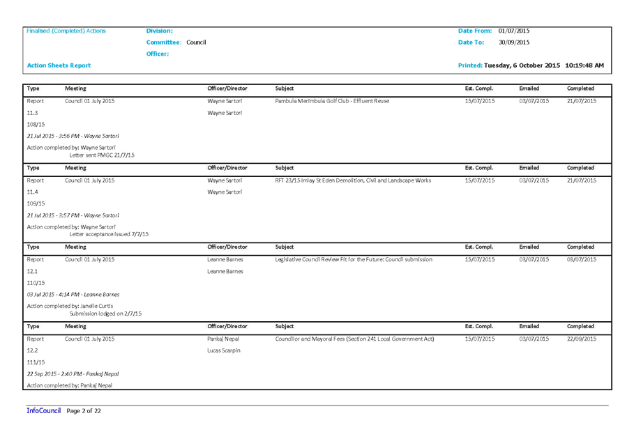
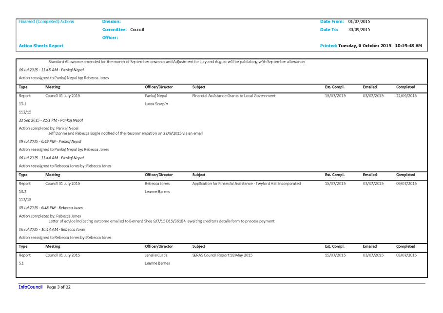
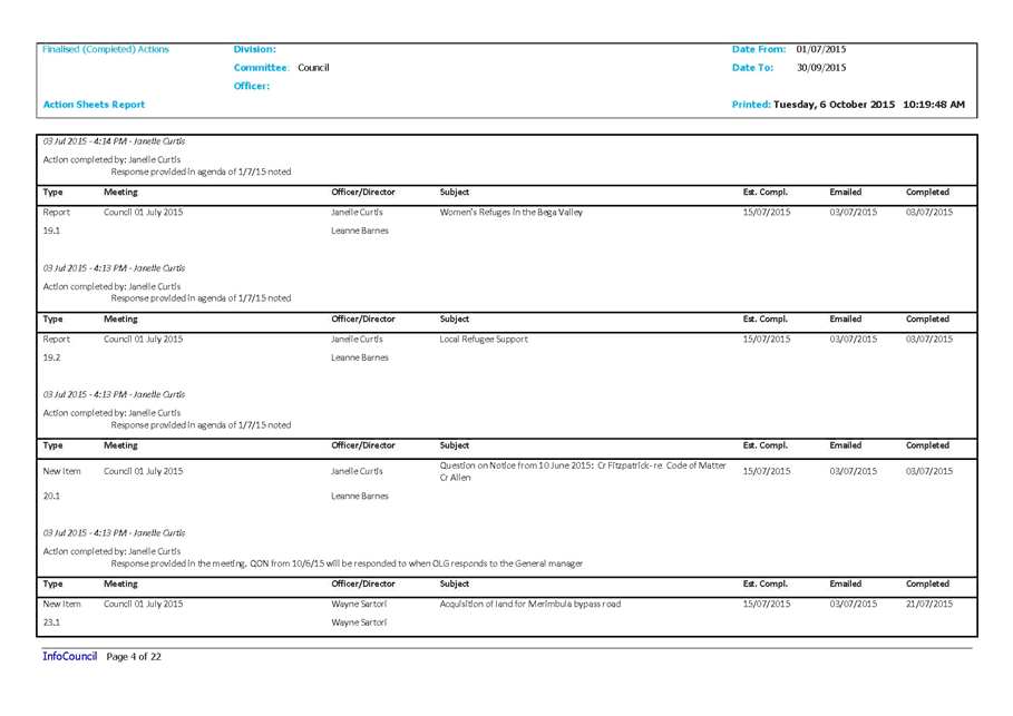
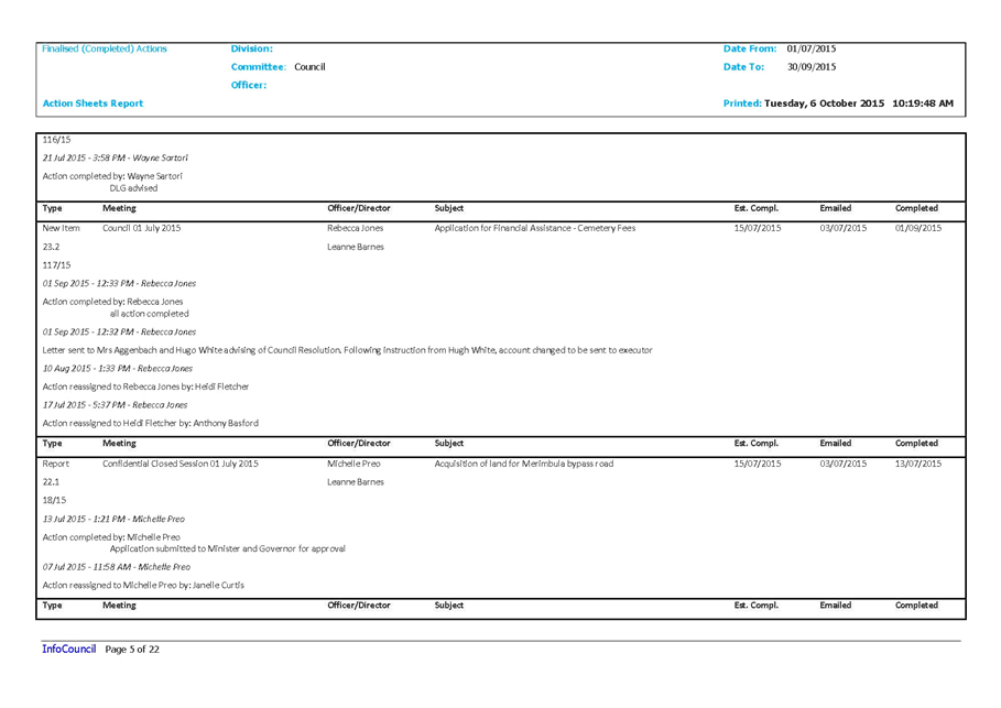
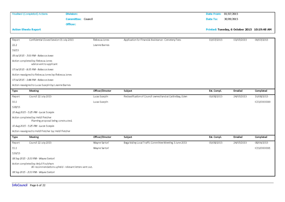
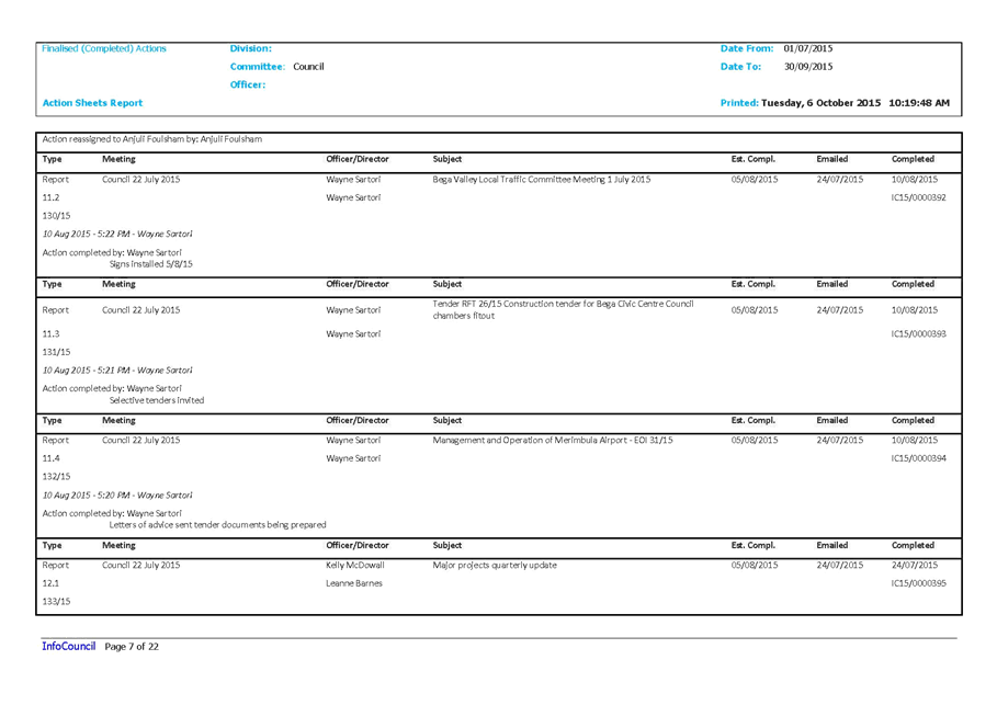
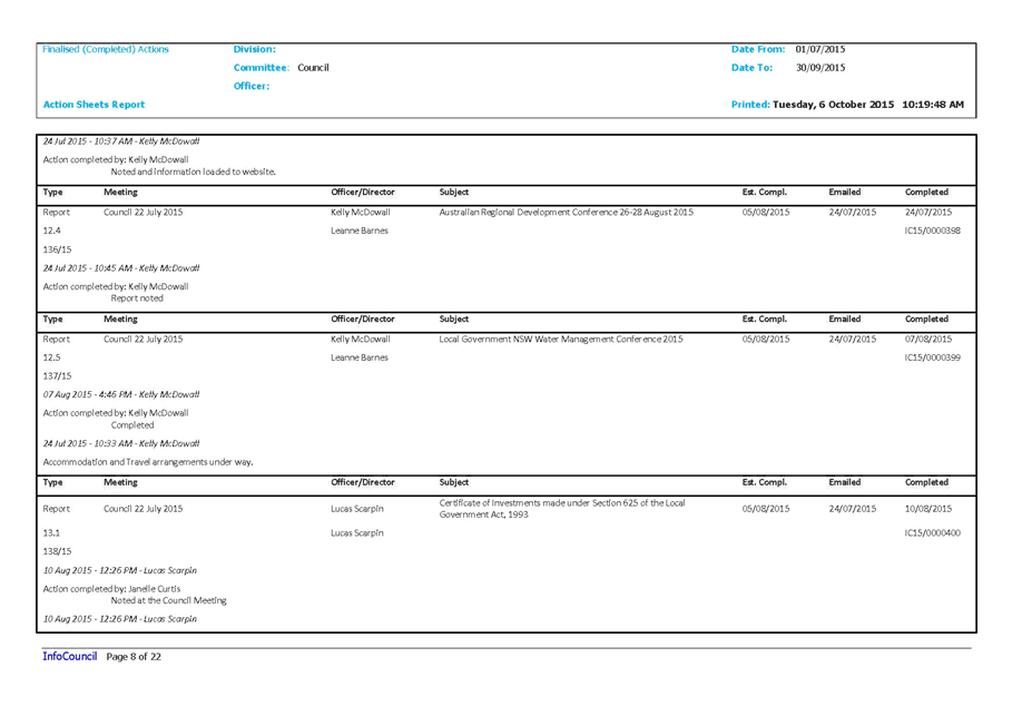
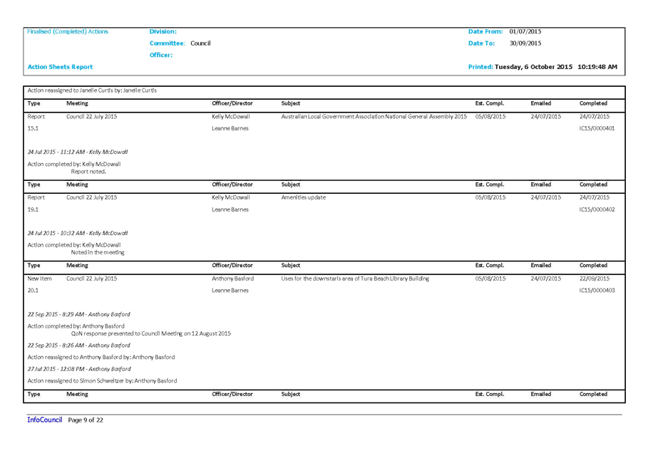
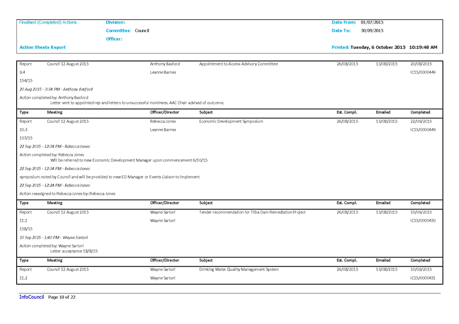
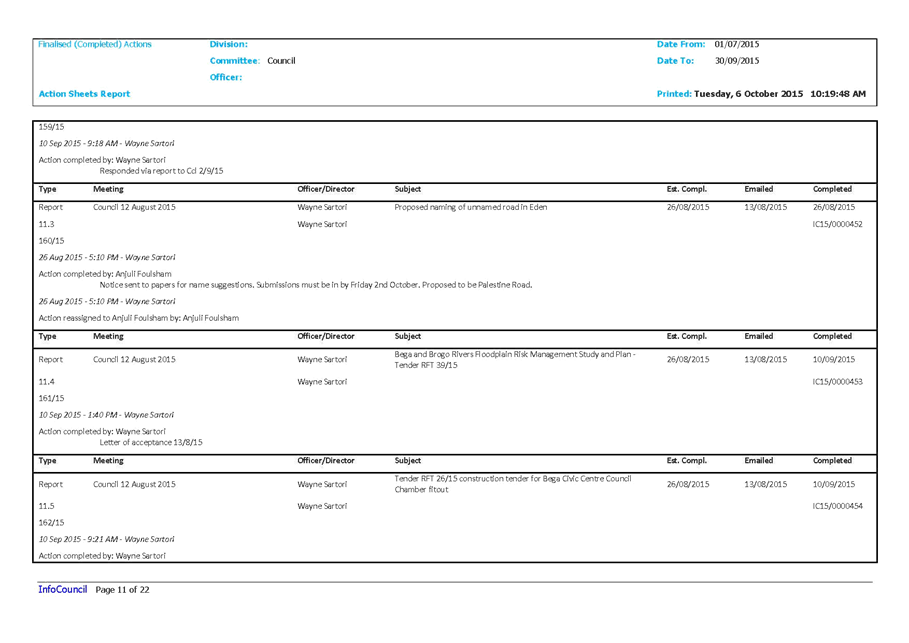
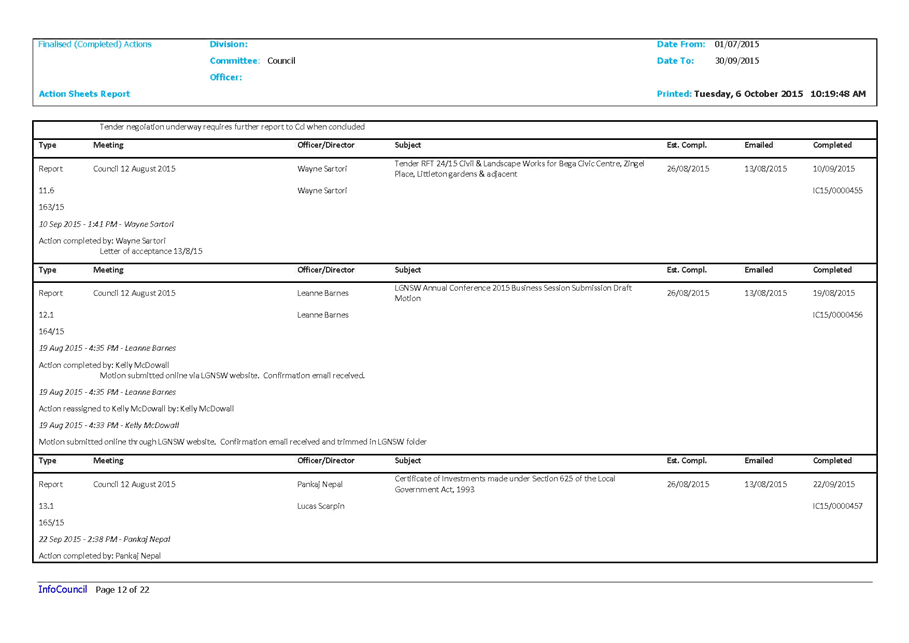
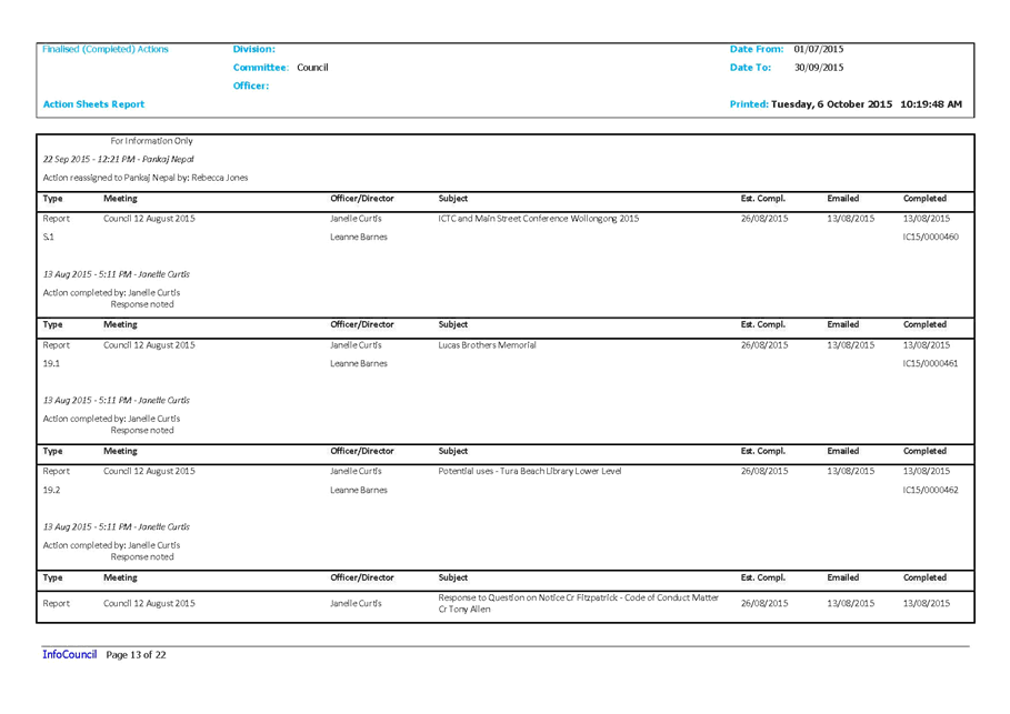
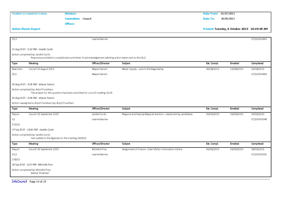
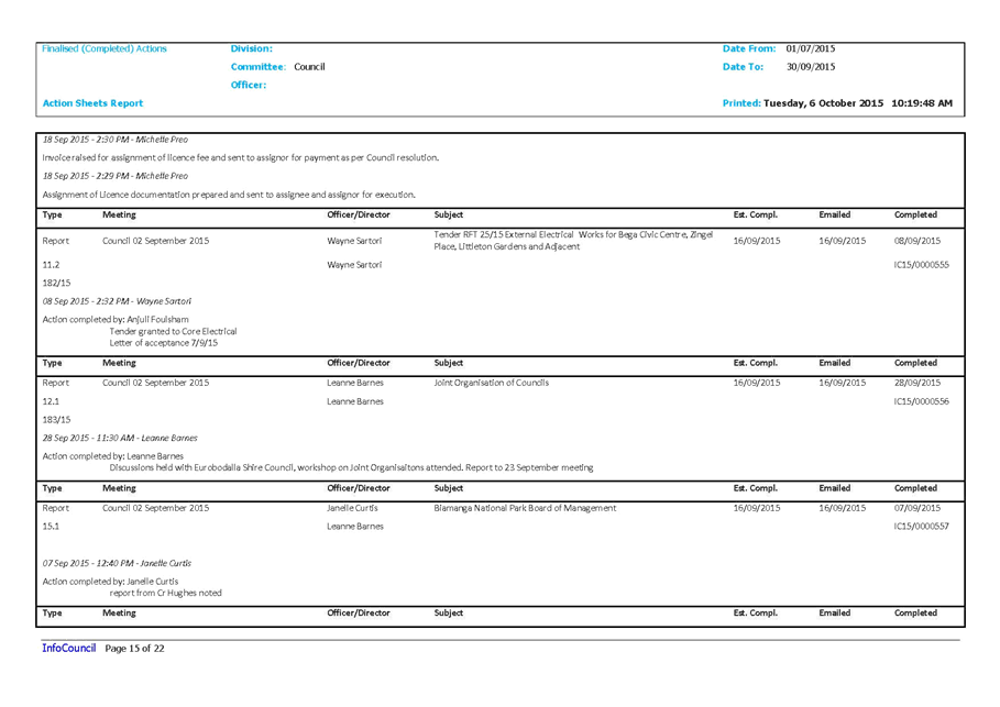
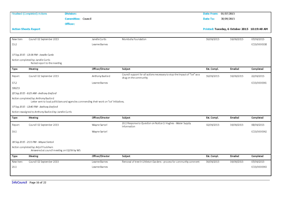
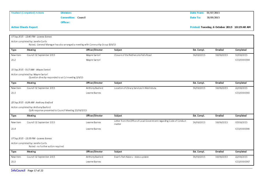
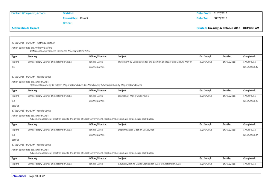
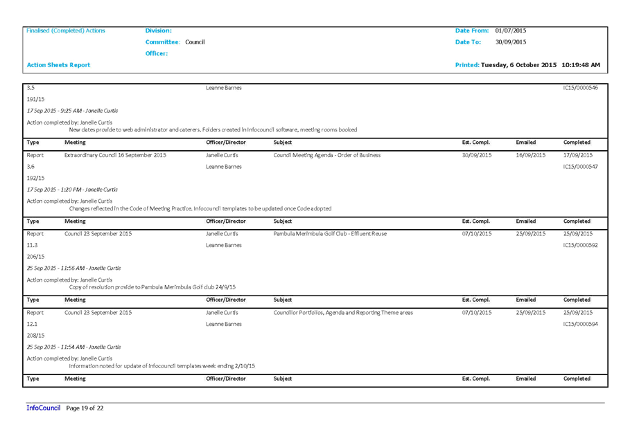
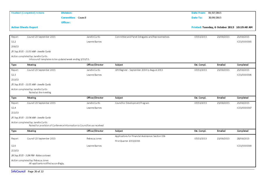
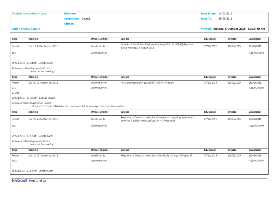
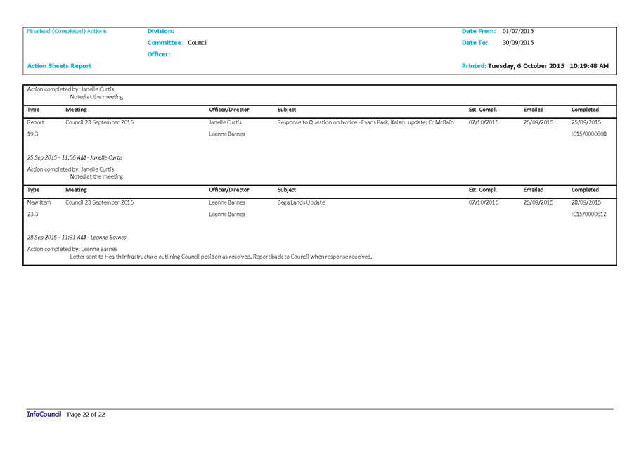
|
Council
|
14 October 2015
|
|
Item 12.2 - Attachment 2
|
Outstanding Council meetings actions 1 July 2015 to 30
September 2015
|
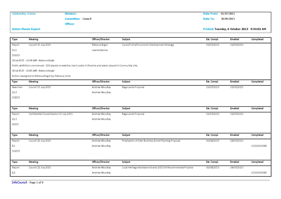
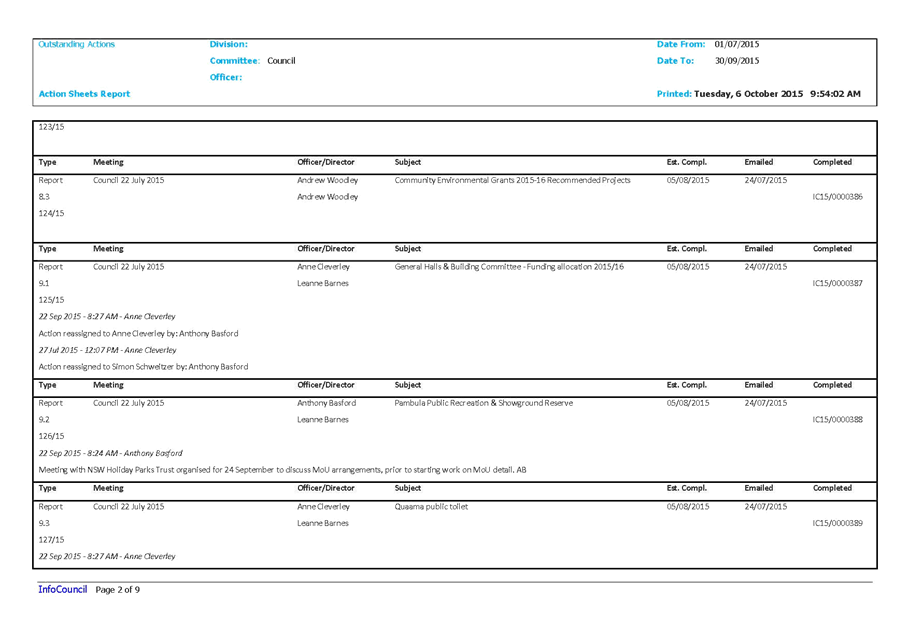
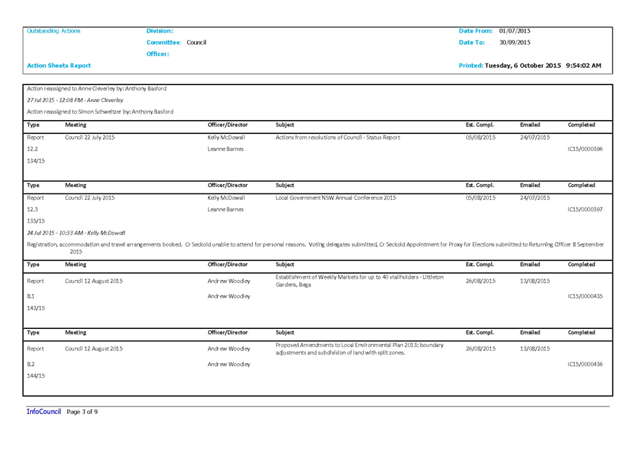
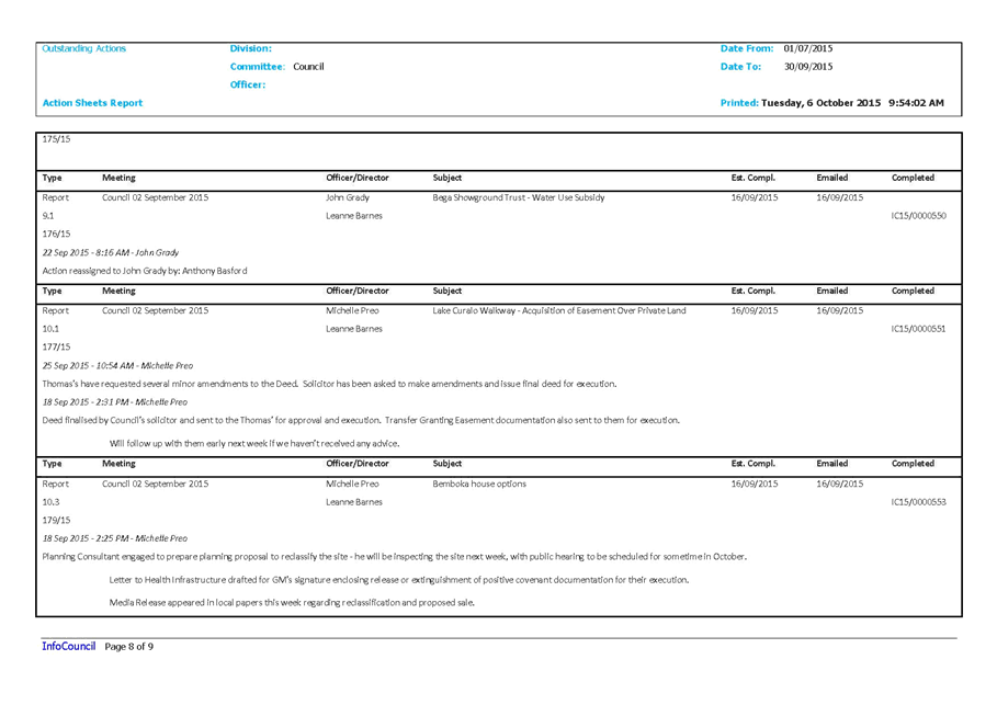
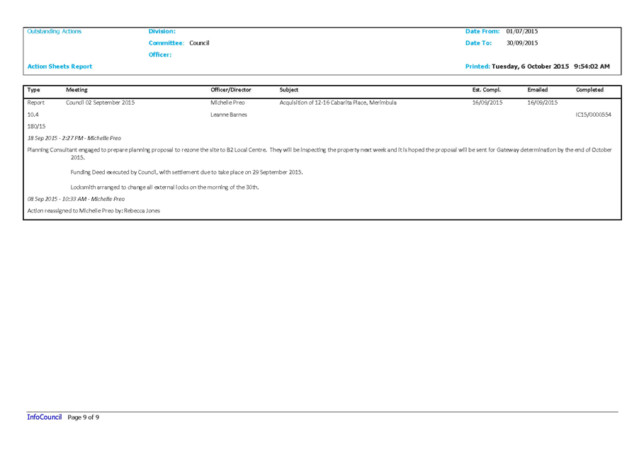
|
Council 14
October 2015
|
Item 12.3
|
12.3. Internal Audit
Committee Yearly Review 2014/15
The purpose of this Internal
Audit Annual Report is to provide information to Council about the activities
of the Internal Audit Committee during the 2014/2015 Financial Year.
General Manager
Background
This is the second Annual Report
of the Bega Valley Shire Council (BVSC) Internal Audit Committee (IAC), which
covers the activities of the Committee for the period July 2014 to June 2015.
The IAC was established by
Council at the first Committee meeting held on 31 August 2009.
The overall aim of the Committee
is to support and assist Council in providing a transparent
and independent review process for its financial and enterprise risk management
practices to ensure accountability to the community in the governance,
management and allocation of resources.
This report outlines the role and
activities of the IAC, which acts in accordance with the duties and
responsibilities, set out in the BVSC Internal Audit Charter.
The audits undertaken during the
reporting period covered by this Annual Report identified several areas for
improvement within Council – this shows the importance of the Internal
Audit function for Council and the value it gives to the organisation as a
whole.
A copy of the report is attached. In
summary:
Membership
Members of the Internal Audit
Committee during 2014/2015 were:
· Chair – Mr.
Terry Bunn, Independent Representative (member since 2013).
· Committee member
– Mr. Geoff Steel, Independent Representative (member since 2009).
· Committee member
– Mr. Roger FitzGerald, Independent Representative (member since 2015).
· Committee member
– Councillor Ann Mawhinney, Councillor Representative (member since
2012).
Additionally, as per the Charter,
the ‘non-voting attendees’ to IAC meetings were:
· The
General Manager;
· Executive
Manager Organisational Development and Governance Unit;
· Group
Manager Strategy and Business Services Group; and the
· Risk
and Internal Audit Coordinator.
Key Activities of the
Audit Committee for 2014/2015
· Three Year Audit
Plan
· Annual Audit Plan
2014/15
· Internal Audit
Committee Charter Revision
· Enterprise Risk
Updates
· IAC Induction
Conclusion
Reflecting upon the achievements of the Committee over the
last twelve months, it is apparent that internal audit is an essential
component promoting a good governance framework for BVSC.
The audits undertaken and reviewed by the Committee have
identified some shortfalls within the administrative operations of Council
indicating scope for reinforcing the current management's efforts for
improvement in internal controls.
The Committee will continue to work with Council in
improving internal audit and risk management frameworks that will in turn
foster and enhance community confidence in Council’s performance.
Attachments
1. Internal
Audit Committee Annual Report 2014/15
|
Recommendation
That Council notes the activities of the Internal Audit
Committee during the period 2014-2015.
|
|
Council
|
14 October 2015
|
|
Item 12.3 - Attachment 1
|
Internal Audit Committee Annual Report 2014/15
|

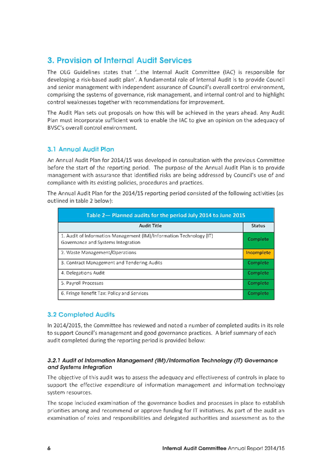

Staff Reports – Finance (Leading Organisation)
14 October 2015
In accordance with Council’s Code of Meeting
Practice (2011), this section of the agenda will be chaired by Cr Hughes.
13.1 Local
Government Grants Commission - financial assistance grants 2015-16 205
13.2 Certificate
of Investments made under Section 625 of the Local Government Act, 1993 239
|
Council 14 October 2015
|
Item 13.1
|
13.1. Local Government Grants Commission - financial assistance grants
2015-16
The Grants Commission have
advised Council in relation to the calculations used and the estimated
entitlements for 2015-16.
General Manager
Background
The NSW Minister for Local Government,
the Hon Paul Toole, and the Deputy Prime Minister and Minister for
Infrastructure and Regional Development, the Hon Warren Truss, have approved
NSW Local Government Grants Commission’s recommendations for the 2015-16
financial assistance grants.
The estimated 2015-16 entitlement for
Bega Valley Shire is $6,674,205. This consists of two components:
General Purpose $4,852,948
Local Roads $1,821,257
As previously advised at the time of the
2014-15 Federal Budget the indexation on the Local Government Financial
Assistance Grants Programme was paused for three years. There has therefore
been no change to the overall national funding pool for CPI and population
growth until 2017-18.
Council was also advised by the NSW
Local Government Grants Commission (LGGC) that “..the general
component of the grants is allocated to States on a population basis. This will
mean the NSW share of the general purpose component grant is expected to
decrease during the period of paused indexation because population growth in
NSW is expected to be below the national average.” This has resulted
in a $107,000 reduction in the budgeted amount in Council’s adopted
Budget for 2015 -16.
The Mayor has written to The Hon Dr
Peter Hendy and The Hon Andrew Constance as our local members to advise of the
impact of this policy approach of the Federal Government and the NSW LGGC
assessment on this Council’s budget for the current year. It is imperative
that this slow eroding of a key source of funding is addressed.
There are a number of Motions on this
matter to be considered at the LGNSW Conference in Sydney over the period 11
– 13 October 2015, the outcome of which will be able to be to be reported
to the meeting on the day.
Council has been provided with details
about the way the NSW LGGC calculates Financial Assistance Grants. A copy of
the circular is attached to this report.
Appendix A of the circular outlines the
various factors considered by the Grants Commission as they relate to Bega
Valley Shire. Appendix C details the disability factors
Appendix B outlines the explanation of
calculation summaries for 2015-16.
The circular also invites submissions
from councils in relation to the distribution of financial assistance grants
for 2016-17. Bega Valley has previously made submissions to the LGGC covering
requests that the following matters be considered in relation to its
calculations for the Bega Valley and other similar local government areas
(LGAs):
· targeted
statistical research into tourism to appropriately calculate visitor loads on
LGAs and adjustment of the disability factors accordingly.
· consideration
of the loss of rate income from large areas of some LGAs being non-rateable as
they are designated State Forest and National Parks, particularly as this
relates to business operations in some State Forests and National Parks.
· consideration
of the introduction of a new disability factor recognising aggregate effect of
climate change on local government areas. This includes the impost on
Council’s planning and managing infrastructure and other property
services affected by the combination of bushfire, flood, storm and sea level
rise – most of which are beyond the scope of recovery from insurance
claims and government grants.
· consideration
of varying the minimum allocation based on population, cognisant of compounding
effect of rapid growth on coastal areas that are incapable of population and
development intensification.
· consideration
of merging comparative data statistics with the Office of Local Government to
minimise data collection effort and streamline annual reporting of information
and benchmarking to the industry and community.
It would appear that whilst there have
been some moves in the disability factors, for example recognition of flood
prone buildings, beach lifesaving, and climate measures, non-resident (tourism)
use of recreation facilities, other matters have not been directly addressed.
Guidelines for special submissions in
relation to 2016-17 Grants are attached at Appendix D.
Special submissions can be lodged
relating to the financial impact of inherent expenditure disabilities beyond
its control that are not generally recognised in the current methodology. Submissions
are required to be lodged by 30 November 2015.
Issues
Legal
The
NSW LGGC makes recommendations to the Minister for Local Government on the
allocation of general purpose grants to local governing bodies in New
South Wales under the provisions of the Commonwealth
Local Government (Financial Assistance) Act, 1995.
Financial
Council’s allocation of
funding from financial assistance grants for 2015-16 will result in a deficit
of $107k compared to Council’s adopted Budget. This will be adjusted in
September QBRS where budgetary cuts are required in various service areas. The
two areas that have currently been identified for reduction in the General
Purpose area, of $96,052, are training and seminars and Council financial
grants programs. More detail will be presented to Council with the quarterly
review.
Council’s
Allocation Council’s
Budget Deficit
General
Purpose $4,852,948 $4,949,000 ($96,052)
Local
Roads $1,821,257 $1,832,500 ($11,243)
Total $6,674,205 $6,781,500 ($107,295)
Trending for this grant over
recent years has seen loss of revenue for Council in real terms and this will
be amplified due to the current indexation freeze which is expected to continue
until at least 2017-18.
|
2011-2012
|
2012-2013
|
2013-2014
|
2014-2015
|
2015-2016
|
|
Local Government Cost Index [LGCI]
|
2.80%
|
3.80%
|
3.40%
|
2.30%
|
2.40%
|
|
BVSC Entitlement [a]
|
6,511K
|
6,676K
|
6,800K
|
6,740K
|
6,674K
|
|
BVSC's Estimated Entitlement [b]
[If LGCI was applied on Year
on Year
Base Year being 2011]
|
6,638K
|
6,890K
|
7,125K
|
7,289K
|
7,463K
|
|
Estimated Loss of Revenue [c = b - a]
|
128K
|
215K
|
325K
|
549K
|
789K
|

Operational Plan
The Financial Assistance Grant is
a significant funding source contributing to the implementation of
Council’s Operational Plan.
Conclusion
It is considered appropriate that
Council again raise with the LGGC the disability factors faced by this LGA
which are not currently reflected in the current disability calculations.
Attachments
1. Notification
of Estimated FAGs Entitlement 2015-16
2. Detailed
Summary of FAGs Entitlement 2015-16 Calculation
|
Recommendation
1. That
Council note the approved Financial Assistance Grant in two parts for
2015-16.
2. That
Council make a submission to the NSW Local Government Grants Commission
relating to the 2016-17 grants to present information on the financial impact
of inherent expenditure disabilities beyond its control that are not
generally recognised in the current methodology.
|
|
Council
|
14 October 2015
|
|
Item 13.1 - Attachment 1
|
Notification of Estimated FAGs Entitlement 2015-16
|
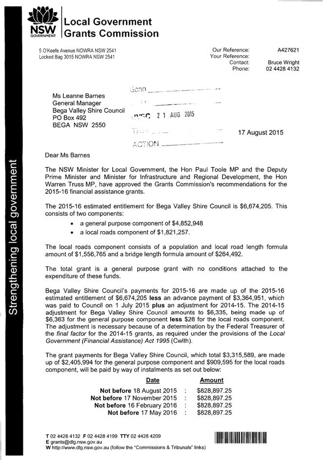
|
Council
|
14 October 2015
|
|
Item 13.1 - Attachment 2
|
Detailed Summary of FAGs Entitlement 2015-16 Calculation
|

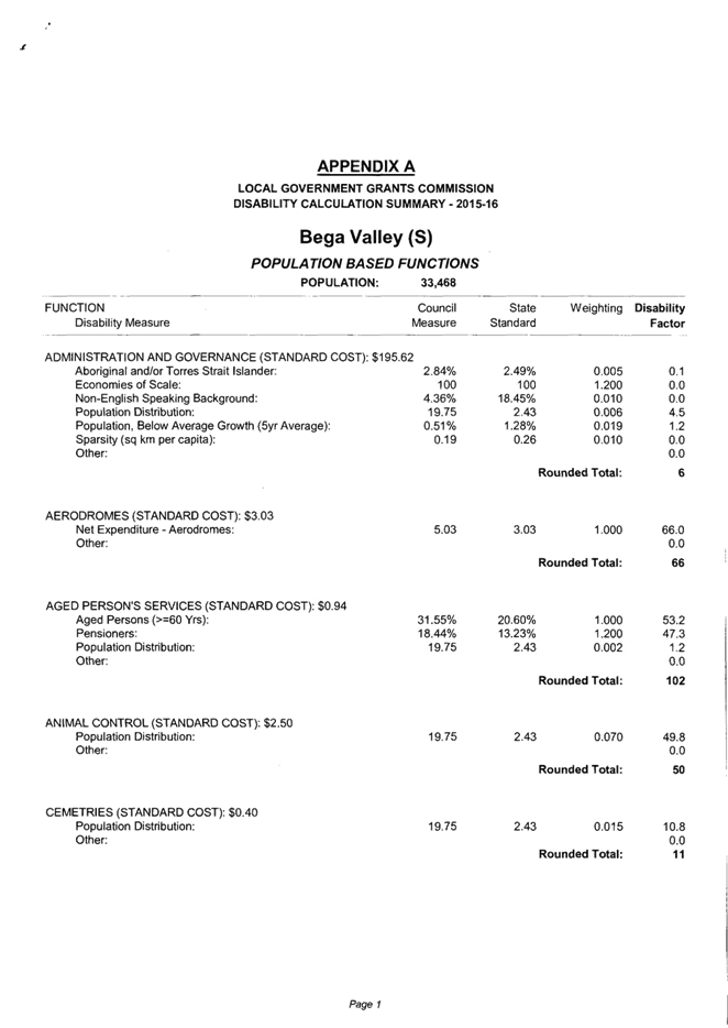
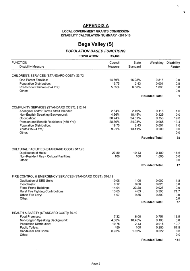
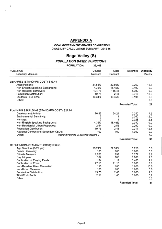
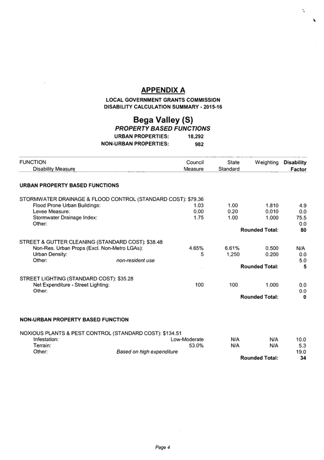
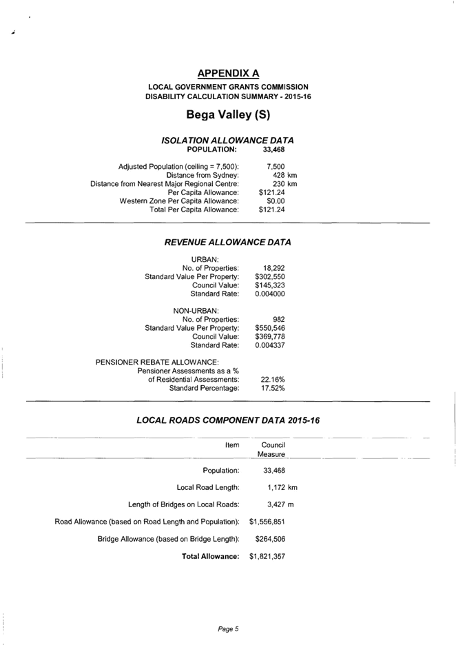
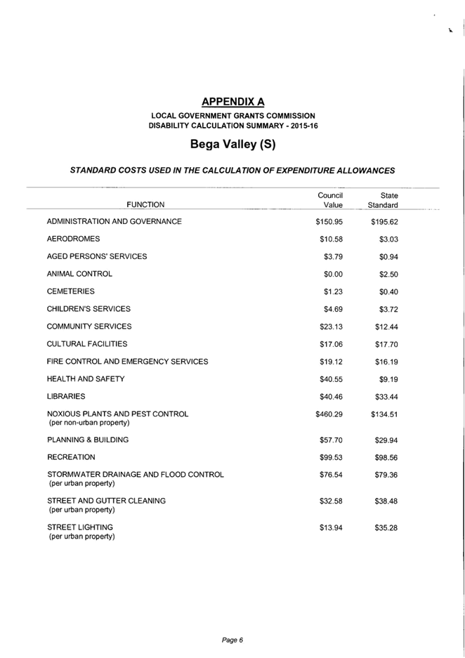
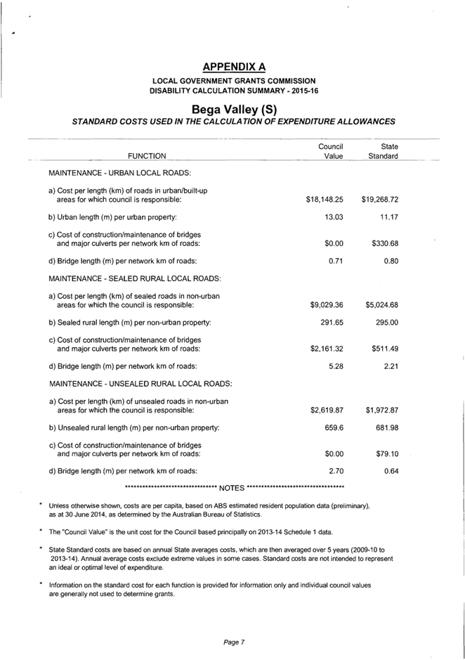
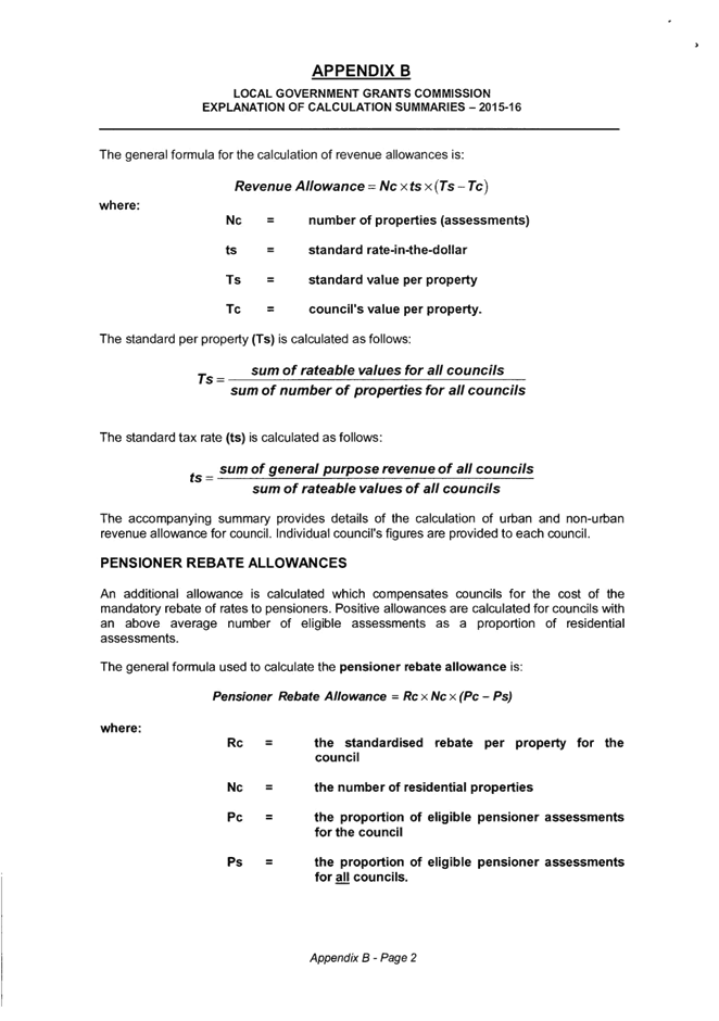

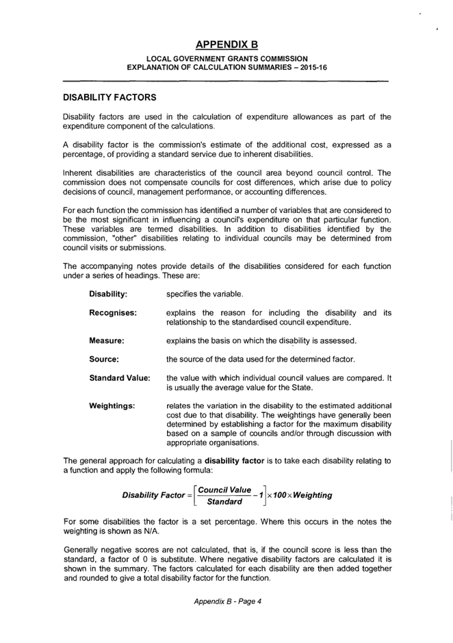
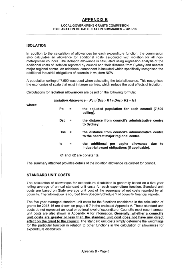
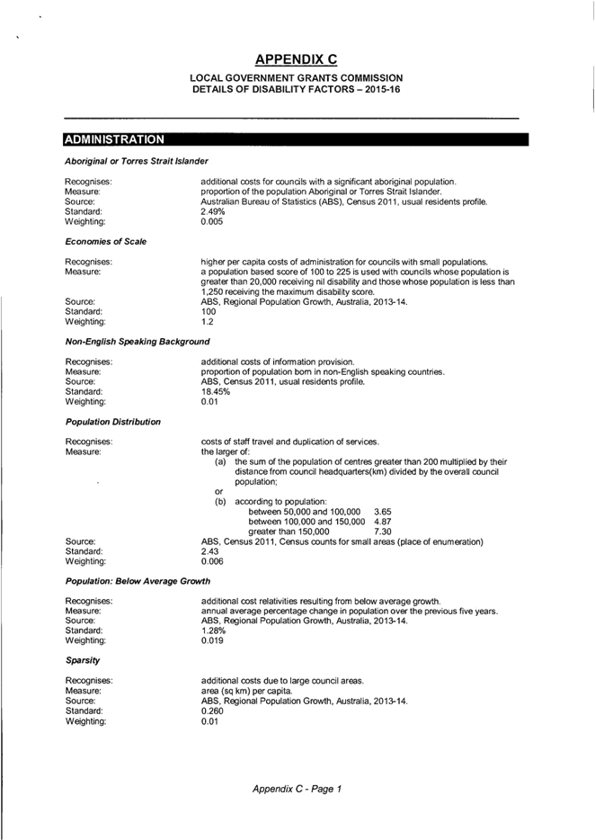
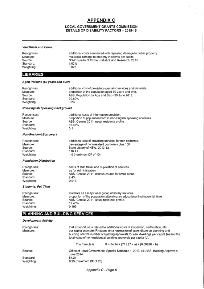
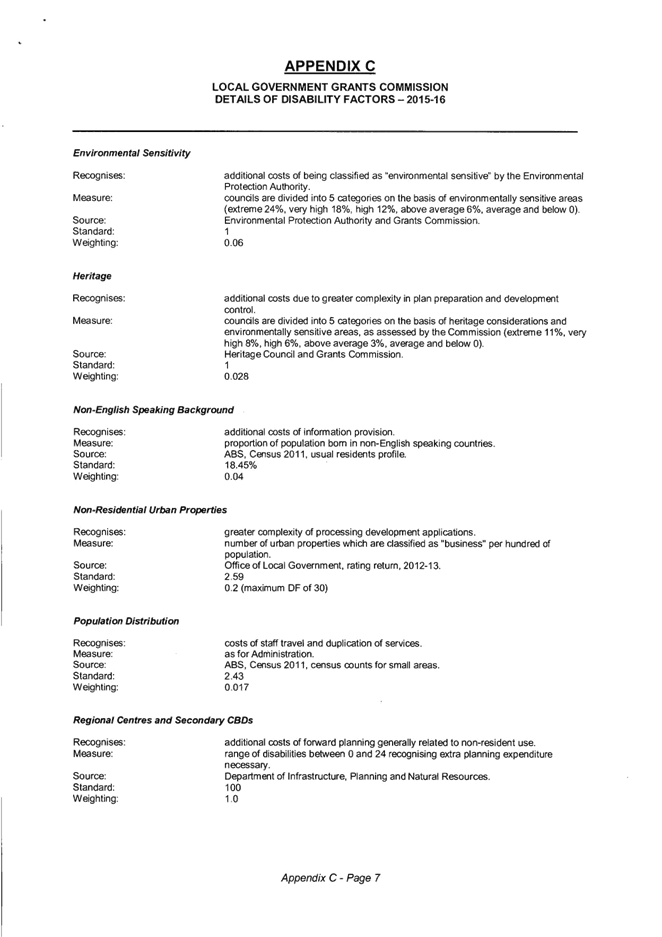
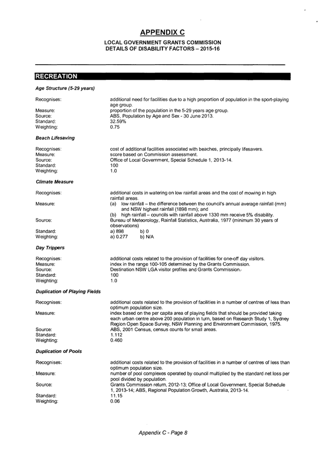
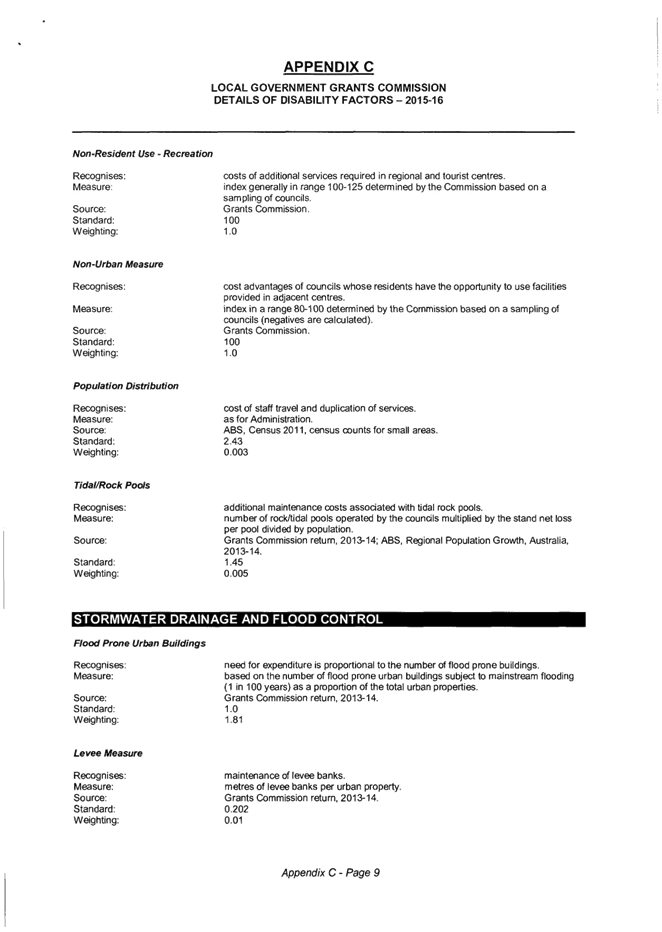
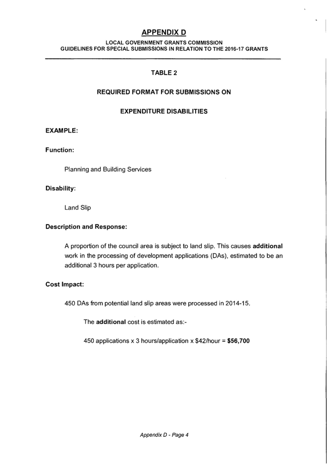
|
Council 14
October 2015
|
Item 13.2
|
13.2. Certificate of
Investments made under Section 625 of the Local Government Act, 1993
Report details
Council’s investments during the month of September 2015.
Group Manager Strategy and Business
Services
Background
Under the legislation and regulations mentioned below, the
Responsible Accounting Officer must present to Council on a monthly basis the
status of the investments held by Council. The Responsible Accounting Officer
must detail the investments held, and their compliance with both internal
policy and external regulation under the Ministerial Order of Investments.
In accordance with the recommendations made by the Office of
Local Government (OLG) Investment Policy Guidelines published in May 2010, the
Strategy and Business Services section has made the monthly Investments Report
an attachment to the Business Paper. This allows a stand-alone report to be
published on Council’s website for the public to view without having to
peruse the Council’s Agenda for the relevant meeting.
Issues
Legal
Section 625 of the Local Government Act 1993 (the
Act) determines money may only be invested in a type of investment authorised
by order of the Minister for Local Government and published in the Local
Government Gazette. The most recent Ministerial Order of Investment was
published February 17, 2011.
Clause 212 of the Local Government (General) Regulation 2005
determines the Responsible Accounting Officer must provide Council with a
written report setting out details of all money Council has invested under
section 625 of the Act.
The report must also include a Certificate as to whether or
not the investments have been made in accordance with the Act, the Regulations
and the Council’s Investment Policy.
Policy
Council has an Investment Policy published under policy
number 5.07. This Policy is reviewed every 4 years by Council and annually by
Council staff.
Council’s current Policy allows for investment of
funds in cash term deposits only with rated Authorised Deposit-Taking Institutions
(ADI’s). Council does not hold any investments in sub-prime or managed
fund products. At this time, Council holds no long term deposits nor any
deposits introduced through an agent.
Financial
The attached report indicates a current investment portfolio
of $48,000,000.
These funds can be broken into the following Funds:
Table
1: Investments by Fund
|
Funding source
|
June 2015
|
July 2015
|
August 2015
|
|
General Fund
|
$21,004,000
|
$16,004,000
|
$13,004,000
|
|
Water Fund
|
$16,796,000
|
$16,796,000
|
$16,796,000
|
|
Sewer Fund
|
$15,200,000
|
$15,200,000
|
$15,200,000
|
In addition, there is $4,880,000 in
uninvested funds in Council’s operating account and another $5,000,000 in
Council’s Corporate Transaction Account
8 Each
fund’s allocation can only be utilised on its specific operations. For
example, Water Fund cannot use its financial resources on General Fund
projects, etc.
8 Externally
Restricted is defined by purposes that are “restricted” by external
legislation or regulations, such as unspent grants or loans tied to a specific
project, or development contributions held for expenditure in accord with an
adopted s94/s64 contributions plan.
8 Internally
Restricted is defined by “restrictions” placed upon the use of these
funds by Council internally, such as asset replacement, weeds, property,
employee entitlements and the like.
8 Unrestricted
funds are available for day to day operational uses, or emergencies. Those
funds are reviewed daily for short term investment, depending on revenue cycles
such as rates instalments.
Table
2: Restricted Cash and Investment by Fund
|
Funding source
|
External Restrictions
‘000
|
Internal Restrictions
‘000
|
Unrestricted ‘000
|
Total
‘000
|
|
General Fund
|
$9,528
|
$10,264
|
$3,092
|
$22,884
|
|
Water Fund
|
$5,099
|
$11,697
|
|
$16,796
|
|
Sewer Fund
|
$3,255
|
$11,945
|
|
$15,200
|
The restrictions reported in Table
2 relate to 30 June 2014.
Council formally calculates its Restrictions as at 30 June
each year. These Restrictions are not reset until the following year Financial
Audit. Any movement of funds during the year, is therefore, shown as movement
in unrestricted cash.
There have been expenditures between July and year to date
that will result in reduced restrictions (for example transfers from reserves
to fund capital works), but is not reflected in the above table.
Attachments
1. Investment
Report September
|
Recommendation
1. That
Council receive and note the attached report indicating Council’s
Investment position.
2. That
Council note the Certificate of the Responsible Accounting Officer.
|
|
Council
|
14 October 2015
|
|
Item 13.2 - Attachment 1
|
Investment Report September
|
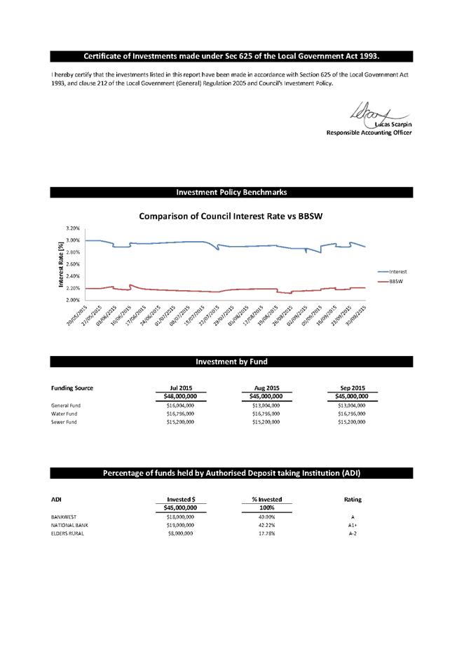
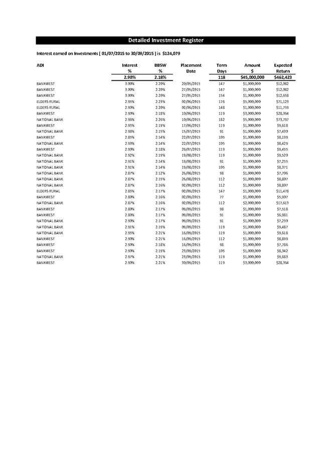
Delegates
Reports
14 October 2015
15.1 Cr
Britten: 2015 LGNSW Water Management Conference ............................ 244
|
Council 14 October 2015
|
Item 15.1
|
15.1. Cr Britten: 2015 LGNSW Water Management Conference
The annual Local Government
NSW (LGNSW) Water Management Conference presents a broad range of information
on issues associated with water supply and sewerage services provided by local
water utilities.
This report outlines a number
of key issues presented at the conference and provides additional detail via a
website link to the items presented.
Cr Britten, Mayor
Background
The LGNSW Water Management Conference is an opportunity for
delegates to network and debate current water issues. This year the BVSC Mayor
and Manager Water and Sewerage Services attended the Conference held at Bowral
in the NSW Southern Highlands.
The Conference covered a variety of subjects, notably NSW
Government policy priorities, regulatory reforms, institutional arrangement
(including Joint Organisations of Councils), water supply security, risk based
water quality management plans, coal seam gas, ice pigging, community
consultation, private sector involvement and health-based drinking water
targets.
The Conference also included a number of trade presentations
and vendor displays by Conference sponsors.
The three day Conference covered an extensive range of
topics, well beyond the brief scope of this report. A link to the full suite of
presentations is provided below and further specific information can be
provided on any of the items, if required by Councillors.
http://www.lgnsw.org.au/waterconference
Conclusion
The annual LGNSW Water Management Conference provides a
valuable learning and networking opportunity for Councillors and staff and
should be an annual event for BVSC. In conclusion, it is suggested the web
based presentations from the Conference be viewed and that further
workshops/information be provided as required.
Attachments
Nil
Questions On
Notice
14 October 2015
19.1 Off-road
bike path options for Tathra to Kalaru and Kalaru to Bega .............. 246
|
Council 14 October 2015
|
Item 19.1
|
19.1. Off-road bike path options for Tathra to Kalaru and Kalaru to
Bega
Cr Liz Seckold asked as
question at the Council meeting on 23 September regarding the Bega Valley Bike
Plan 2014, for the sections from Tathra to Kalaru and from Kalaru to Bega.
Group Manager Transport and Utilities
Question
for the Next Meeting Heading
At the Council Meeting on 23 September, 2015, Cr Liz
Seckold asked could Council provide a range of costings for the provision of an
off-road bike plan, as per the Bega Valley Bike Plan 2014, for the sections
from Tathra to Kalaru and from Kalaru to Beg
A full report to Council is included in the Agenda for
the meeting 14 October 2015. For full information and the recommendation
please refer to:
· Transport and Utilities Report: Off-road bike
path options for Tathra to Kalaru and Kalaru to Bega.
Attachments
Nil