|

Ordinary
Meeting Notice and Agenda
An Ordinary Meeting of the Bega Valley Shire Council will be held at Council Chambers, Bega on Wednesday, 14 December 2016 commencing at 2.00
PM to consider and resolve on the matters set out in
the attached Agenda.
9
December 2016
To:
Cr Kristy McBain, Mayor
Cr Liz Seckold, Deputy Mayor
Cr Tony Allen
Cr Robyn Bain
Cr Jo Dodds
Cr Russell Fitzpatrick
Cr Cathy Griff
Cr Mitchell Nadin
Cr Sharon Tapscott
|
Copy:
General Manager, Ms Leanne Barnes
Director, Transport and
Utilities, Mr Terry Dodds
Director, Planning and
Environment, Mr Andrew Woodley
Director, Community, Relations
and Leisure, Mr Anthony Basford
Director, Strategy and
Business Services, Mr Lucas Scarpin
Executive Manager
Organisational Development and Governance, Ms Nina Churchward
Minute Secretary, Ms Kelly McDowall
|
|
Live Streaming of Council Meetings
Council meetings are recorded and live streamed to the
Internet for public viewing. By entering the Chambers during an open
session of Council, you consent to your attendance and participation being
recorded.
The recording will be archived and made available on
Council’s website www.begavalley.nsw.gov.au. All care is taken to
maintain your privacy; however as a visitor of the public gallery, your
presence may be recorded.
Publishing Of Agendas And Minutes
The Agendas for Council Meetings and Council Reports for
each meeting are available from 5.00 pm one week prior to each Ordinary
Meeting, on Council’s website. A hard copy is also made available
to each Library Branch and at the Bega Administration Building reception desk.
The Minutes of Committee and Council Meetings are available
from 5.00pm on Council's Web Site on the Friday after the Meeting on Councils
website and hard copies distributed with the Agenda for the following meeting.
1. Please
be aware that the recommendations in the Council Meeting Agenda are recommendations
to the Council for consideration. They are not the resolutions
(decisions) of Council.
2. Background
for reports is provided by staff to the General Manager for presentation
to Council.
3. The
Council may adopt these recommendations, amend the recommendations, determine a
completely different course of action, or it may decline to pursue any course
of action.
4. The
decision of the Council becomes the resolution of the Council, and is recorded
in the Minutes of that meeting.
5. The
Minutes of each Council meeting are published in draft format, and are
confirmed, with amendments by Councillors if necessary, at the next available
Council Meeting.
If you require any further information or clarification
regarding a report to Counci, please contact Council’s Executive
Assistant who can provide you with the appropriate contact details
Phone (6499 2104)
or email execassist@begavalley.nsw.gov.au.
Ethical Decision Making and Conflicts of
Interest
A guiding checklist for Councillors, officers and community committees
Ethical decision making
·
Is the decision or conduct legal?
·
Is it consistent with Government policy, Council’s
objectives and Code of Conduct?
·
What will the outcome be for you, your colleagues, the Council,
anyone else?
·
Does it raise a conflict of interest?
·
Do you stand to gain personally at public expense?
·
Can the decision be justified in terms of public interest?
·
Would it withstand public scrutiny?
Conflict of interest
A conflict of interest is a clash between private interest
and public duty. There are two types of conflict:
·
Pecuniary
– regulated by the Local Government Act 1993 and Office of
Local Government
·
Non-pecuniary
– regulated by Codes of Conduct and policy. ICAC,
Ombudsman, Office of Local Government (advice only). If declaring a
Non-Pecuniary Conflict of Interest, Councillors can choose to either disclose
and vote, disclose and not vote or leave the Chamber.
The test for conflict of
interest
·
Is it likely I could be influenced by personal interest in
carrying out my public duty?
·
Would a fair and reasonable person believe I could be so
influenced?
·
Conflict of interest is closely tied to the layperson’s
definition of ‘corruption’ – using public office for private
gain.
·
Important to consider public perceptions of whether you have a
conflict of interest.
Identifying problems
1st Do
I have private interests affected by a matter I am officially involved in?
2nd Is
my official role one of influence or perceived influence over the matter?
3rd Do
my private interests conflict with my official role?
Whilst seeking advice is generally useful, the ultimate
decision rests with the person concerned.
Agency advice
Officers of the following agencies are available during
office hours to discuss the obligations placed on Councillors, officers and
community committee members by various pieces of legislation, regulation and
codes.
|
Contact
|
Phone
|
Email
|
Website
|
|
Bega
Valley Shire Council
|
(02)
6499 2222
|
council@begavalley.nsw.gov.au
|
www.begavalley.nsw.gov.au
|
|
ICAC
|
8281
5999
Toll
Free 1800 463 909
|
icac@icac.nsw.gov.au
|
www.icac.nsw.gov.au
|
|
Office
of Local Government
|
(02)
4428 4100
|
olg@olg.nsw.gov.au
|
http://www.olg.nsw.gov.au/
|
|
NSW
Ombudsman
|
(02)
8286 1000
Toll
Free 1800 451 524
|
nswombo@ombo.nsw.gov.au
|
www.ombo.nsw.gov.au
|
TO: The
General Manager
Bega Valley Shire Council
Disclosure of pecuniary interests / non-pecuniary conflict of interests
In accordance with the Council’s Code of Meeting
Practice and the requirements of the Local Government Act 1993 and
regulations or dispensation issued by the Office of Local Government I
hereby disclose the following pecuniary interests and/or non-pecuniary conflict
of interests at the meeting as indicated below:
Ordinary meeting held on _____ / _____ / 20___
dd mm yy
|
Item no
& subject
|
|
|
Interest (tick one)
|
Pecuniary
interest Non-pecuniary
conflict of interest
|
|
* Nature of
interest
|
|
|
If
Non-pecuniary (tick
one)
|
Disclose
& vote Disclose
& not vote Leave
chamber
|
|
|
|
|
|
|
|
Item no
& subject
|
|
|
Interest (tick one)
|
Pecuniary
interest Non-pecuniary
conflict of interest
|
|
* Nature of
interest
|
|
|
If
Non-pecuniary (tick
one)
|
Disclose
& vote Disclose
& not vote Leave
chamber
|
|
|
|
|
|
|
* Note: Under the provisions of Section
451(1) of the Local Government Act 1993 (pecuniary interests) and Part 4
of the Model Code of Conduct prescribed by the Local Government (Discipline)
Regulation (conflict of interests) it is necessary for you to disclose the
nature of the interest when making a disclosure of a pecuniary interest or a
non-pecuniary conflict of interest at a meeting.
Agenda
Statement of Commencement of Live Streaming
Acknowledgement of Traditional Owners of Bega Valley Shire
1 Apologies and requests for leave of
absence
2 Confirmation Of Minutes
Recommendation
That the Minutes of the Ordinary Meeting and Closed session
held on 23 November 2016 as circulated, be taken as read and confirmed.
3 Declarations
Pecuniary,
Non-Pecuniary and Political Donation Disclosures to be declared and tabled.
4 Deputations (by prior arrangement)
The following persons have been granted permission to
address Council and to respond to questions from Councillors:
Regarding Planning and Environment (Sustainability) Report
No 9.2. South Bega Industrial Lands Planning Proposal - Results of Public
Exhibition:
• Mr Gerry Tarlinton, on
behalf of L K Blacker & Sons.
Regarding Planning and Environment (Sustainability) Report
No 9.3 Finalisation of Amendment to Local Environmental Plan 2013 - Bournda
Downs, Sapphire Coast Drive, Wallagoot:
• Mr Doug Reckord.
Regarding Planning and Environment (Sustainability) Report
No 9.6.DA No. 2014.430: Modification to Development Consent - Cattle Bay Marina
Development:
• Mr Mike Skitt, on behalf
of Eden Resorts Hotel and Marina Developments.
5 Petitions
6 Mayoral Minutes
6.1 Section
64 contributions................................................................................................................. 9
7 Urgent Business
8 Adjournment to Standing Committees
Recommendation
That the Ordinary meeting of the
Council be adjourned for the purpose of dealing with staff reports to Standing
Committees.
9 Staff Reports – Planning and
Environment (Sustainability)
In accordance with Council’s Code of Meeting Practice,
this section of the agenda will be chaired by Cr Seckold.
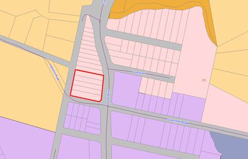
9.1 12
Lot Subdivision Lot 71 DP 1074392 and Lot 341 DP 1222135 - 243 Mount Darragh
Road and 12 Redfern Close, South Pambula................................................................................................................. 11
9.2 South
Bega Industrial Lands Planning Proposal - Results of Public Exhibition...................... 31
9.3 Finalisation
of Amendment to Local Environmental Plan 2013 - Bournda Downs, Sapphire Coast
Drive, Wallagoot..................................................................................................................................... 36
9.4 Finalisation
of Amendments to Local Environment Plan 2013 - Undefer Various Sites .... 42
9.5 Entrance
Management Policies for BVSC Lakes and Lagoons ........................................... 48
9.6 Modification
to Development Consent - Cattle Bay Marina Development .......................... 55
9.7 The
25th Annual NSW Coastal Conference............................................................................. 126
9.8 Confirmation
of Proposed Minimum Lot Size - Tathra River Estate Stage 3....................... 129
9.9 NSW
Coastal Management Reforms - Draft State Environmental Planning Policy............ 131
10 Staff Reports – Community, Culture and
Leisure (Liveability)
In accordance with Council’s Code of Meeting Practice
, this section of the agenda will be chaired by Cr Griff.
10.1 National
Youth Week 2017 Grants............................................................................................ 138
10.2 Seniors
Festival 2017 Grants .................................................................................................... 141
10.3 Community
Project Proposals.................................................................................................... 144
10.4 Coastal
Accessibility Project and Master Plans ...................................................................... 155
11 Staff Reports
–Economic Development and Business Growth (Enterprising)
In accordance with Council’s Code of Meeting
Practice, this section of the agenda will be chaired by Cr Nadin.
11.1 Classification
of land recently acquired by Council................................................................ 160
11.2 Lease
to Bermagui Pre School................................................................................................... 162
11.3 Bega
Valley Economic Summit Report...................................................................................... 166
11.4 Request
to lease a section of unformed road reserve and permanent road closure at
Bermagui 181
11.5 Community
Consultation - Air Service deregulation.............................................................. 206
11.6 EOI
104/16 142-144 Imlay St. Eden Purchase, restoration and other conditions of
sale 208
12 Staff Reports – Infrastructure Waste and
Water (Accessibility)
In accordance with Council’s Code of Meeting
Practice, this section of the agenda will be chaired by Cr Fitzpatrick.
12.1 Proposed
new road names in Bermagui.................................................................................. 212
12.2 Bega
Valley Local Traffic Committee......................................................................................... 215
12.3 Waste
Collection Contact and Waste Transfer Contract Extension..................................... 216
12.4 RFT
91/16 Supply of Components for Chlorinator Safety System Upgrades...................... 219
12.5 Acquisition
of Easement over Private Land for Water Supply at Bermagui....................... 221
12.6 RFT
93/16 Purchase of Replacement Trucks for Water and Sewer Services Team......... 241
12.7 Transfer
of surplus equipment and structures at Doctor George Mountain to Bega Access
Radio Incorporated (Edge FM).......................................................................................................... 243
12.8 RFT
70/16 Construction of a Domestic and Fire Service to Merimbula Airport................ 246
13 Staff Reports –
Governance and Strategy (Leading Organisation)
In accordance with Council’s Code of Meeting
Practice, this section of the agenda will be chaired by Cr Tapscot
13.1 Council
Meeting Dates 2017...................................................................................................... 250
13.2 Results
of 2016 Community Survey.......................................................................................... 252
13.3 Exhibition
of Draft Community Ambitions................................................................................ 256
13.4 Adoption
of the Code of Meeting Practice.............................................................................. 261
13.5 2017
Bega Valley Shire Citizen and Young Citizen of the Year Award ............................. 291t.
14 Staff Reports – Finance (Leading
Organisation)
In accordance with Council’s Code of Meeting
Practice, this section of the agenda will be chaired by Cr Bain
14.1 Certificate
of Investments made under Section 625 of the Local Government Act, 1993 294.
15 Adoption of Reports from Standing Committees
Recommendation
That all motions recorded in the
Standing Committees, including votes for and against, and acknowledging
declarations of interest already made, be adopted in by the Ordinary Council
meeting.
16 Delegates Reports
17 Rescission/alteration Motions
18 Notices of Motion
18.1 Eden
Pool - heat blanket............................................................................................................. 299
18.2 Safe
Schools Coalition Australia (SCCA).................................................................................... 300
19 Questions On Notice
19.1 Pambula
Recreation and Showground Reserve...................................................................... 303
19.2 Tathra
Headland Path budget allocation.................................................................................. 304
20 Questions for the Next Meeting
21 Confidential Business
Statement of Cessation of Live Streaming for the period of the Closed
Session.
Statement of Re-Commencement of Live Streaming
22 Adoption of reports from Closed Session
23 Resolutions to declassify reports considered in
closed session
Mayoral
Minutes
14 December 2016
6.1 Section
64 contributions........................................................................................ 9
|
Council 14 December 2016
|
Item 6.1
|
6.1. Section 64 contributions
Cr McBain, Mayor
Background
The sewering of the villages through the Bega Valley Sewer
project was a forward thinking project which received significant external
funding and achieved positive environmental outcomes for the Shire. The project
has not yet, however, yielded the economic growth or development in the
villages as intended which was a key outcome for the project.
There are affordable blocks in our villages and many of
these have yet to be developed. To encourage development of these blocks
an opportunity may be available to look at innovative application of headworks
charges which could be payable over a period of 3 to 5 years.
There have also been barriers
to change of use in existing shops currently vacant in our towns and villages
with developer charges being seen as an impediment. The option of looking at
alternative methods of collecting developer contributions in these instances
would provide the opportunity to investigate how to look at affordable options
which would look to encourage new business to “start up”.
Council staff have requested
legal advice as to whether a scheme such as this or a variation of it, may be
available for implementation in the Bega Valley. It appears that there are some
models which would be able to be considered and which would comply with all the
relevant legislation. It is important that Council is able to consider these
policy options particularly as we prepare our important forward planning
framework and the next community strategic plan.
In order to do this it is
important that Council has all the necessary information relating to impacts of
any policy and strategy review, particularly as it impacts the long term
financial plan.
Attachments
Nil
Recommendation
That Council receive a
report on a deferral scheme of Section 64 charges and the report considers
alternate methods of levying such charges.
|
Staff Reports –Planning And Environment (Sustainability)
14 December 2016
In accordance with Council’s Code of Meeting
Practice (2011), this section of the agenda will be chaired by Cr Seckold.
9.1 12
Lot Subdivision Lot 71 DP 1074392 and Lot 341 DP 1222135 - 243 Mount Darragh
Road and 12 Redfern Close, South Pambula............................................................................ 11
9.2 South
Bega Industrial Lands Planning Proposal - Results of Public Exhibition... 31
9.3 Finalisation
of Amendment to Local Environmental Plan 2013 - Bournda Downs, Sapphire Coast
Drive, Wallagoot................................................................................................. 36
9.4 Finalisation
of Amendments to Local Environment Plan 2013 - Undefer Various Sites 42
9.5 Entrance
Management Policies for BVSC Lakes and Lagoons ...................... 48
9.6 Modification
to Development Consent - Cattle Bay Marina Development ...... 55
9.7 The
25th Annual NSW Coastal Conference....................................................... 126
9.8 Confirmation
of Proposed Minimum Lot Size - Tathra River Estate Stage 3... 129
9.9 NSW
Coastal Management Reforms - Draft State Environmental Planning Policy...... 131
|
Council 14 December 2016
|
Item 9.1
|
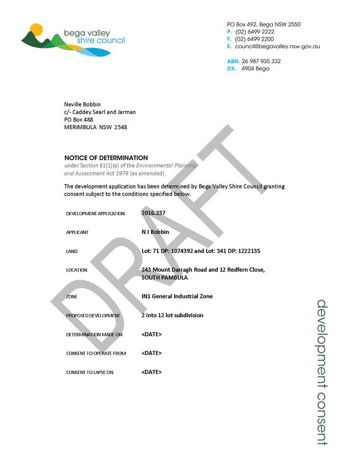
9.1. DA No.
2016.237: 12 Lot Subdivision Lot 71 DP 1074392 and Lot 341 DP 1222135 - 243
Mount Darragh Road and 12 Redfern Close, South Pambula
Director Planning and Environment
|
Applicant
|
Caddey Searl and Jarman
|
|
Owner
|
SK and JA Baird and NJ Bobbins (Bobbins Transport Pty Ltd)
|
|
Site
|
Lots 71 DP 1074392 and Lot 341 DP 1222135 – 243
Mount Darragh Road and 12 Redfern Close, South Pambula
|
|
Zone
|
IN1 General Industrial Zone
|
|
Site area
|
14.65ha
|
|
Proposed development
|
2 into 12 Lot Subdivision
|
Precis
Council is in receipt of a Development Application (DA) for
a 12 lot industrial subdivision.
This subdivision is referred to Council for determination in
accordance with Policy 3.01.4 Councillor/Staff – Determination of
Development Applications as Cr. Russell Fitzpatrick is an employee of
Bobbins Transport Pty Ltd.
Further, one objection was received during the notification
period and the issues raised have formed part of this assessment.
This 12 lot industrial subdivision has been considered in
accordance with the relevant matters for consideration under the BVLEP 2013 and
BVDCP 2013 and is recommended for approval, subject to the conditions outlined
in the Draft Consent.
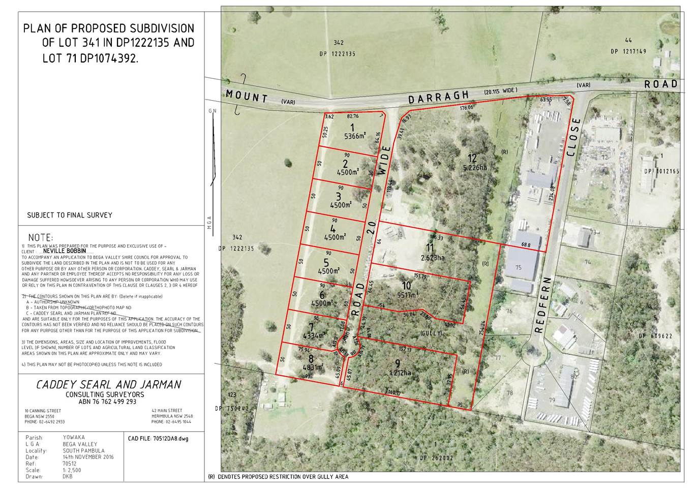
Description of the proposal
This proposal involves the subdivision of 2 existing lots
into 12 industrial lots on Mount Darragh Road and Redfern Close, South Pambula.
The proposal as originally submitted was for 14 allotments, however
was reduced to 12 lots to address the environmental constraints of the land.
The design involves a central access road running through
the site with smaller parcels to the west (proposed Lots 1-8) and larger
allotments to the east (proposed Lots 9-12). The proposal also includes the
consolidation of land fronting Redfern Close (Lot 71 DP 1074392) and a new
service road for the existing dwelling to the south (Lot 1 DP 262002). The
layout is similar to the existing subdivision immediately to the east on
Redfern Close.
See
Attachment 2 – Proposed Subdivision
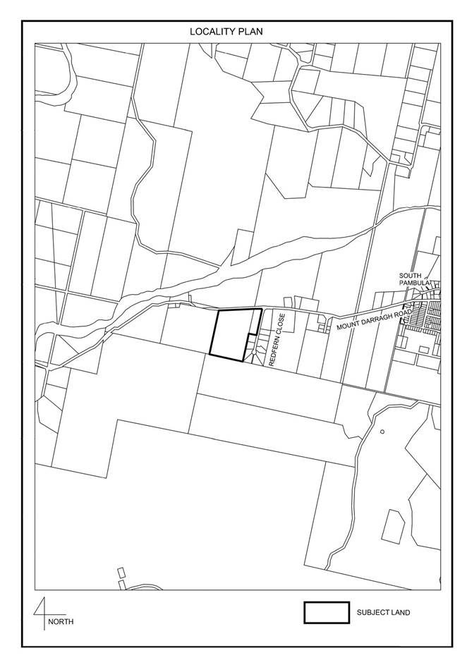
Description of the site
The property
consists of two allotments: Lot 71 DP 1074392 - Redfern Close (1.6ha) and
Lot 341 DP 1222135 - Mount Darragh Road (13.05ha).
Lot 71 DP 1074392 is occupied by an existing transport depot
(Bobbins Transport). Lot 341 DP 1222135 was recently created as part of a
2 lot subdivision (DA 2015.197). This land contains disused industrial
buildings from an old industry (landscaping material supplies).
The land is a mixture of cleared and forested land with a
gentle slope towards the south.
A prominent creek line runs down the eastern side of Lot
341. This includes a dense forested gully near the southern boundary and more
wetland characteristics on the land adjacent to Mount Darragh Road.
See
Attachment 1 – Locality Plan
Planning assessment
The proposal has been assessed in accordance with the
Matters for Consideration under Section 79C of the Environmental Planning
and Assessment Act 1979. Council officers highlight the key issues of the
proposal in this report for Council’s consideration.
A copy of the assessing officer's Section 79C Assessment
will be available at the meeting.
Zoning
The land is
located within the IN1 – General Industrial Zone. There is no minimum lot
size and subdivision is permissible with consent under Clause 2.6 of Bega
Valley Local Environmental Plan 2013.
The objectives of the IN1 General
Industrial Zone are as follows:
· To
provide a wide range of industrial and warehouse land uses
· To
encourage employment opportunities
· To
minimise any adverse effect of industry on other land uses
· To
support and protect industrial land for industrial uses
· To allow a
range of support services that do not have an adverse impact on the viability
of business and commercial zones.
The proposed
subdivision provides for the future development of this industrial land with a
range of potential industrial land uses. The site forms part of an industrial
area that includes some existing dwelling houses and rural land that is limited
in terms of development potential. The impact on residential uses has been
considered within the context of the IN1 zoning and should not preclude the
further subdivision of this land.
The
development is considered to be consistent with the objectives of the zone.
Issues
The
assessment of the DA has identified the following key issues:
Access
The
subdivision involves access onto Mount Darragh Road, which is a regional
classified road.
The Roads
and Maritime Services (RMS) has delegated the responsibility to Council to
determine the appropriateness of the access arrangements. Council’s
Development Engineer has assessed the proposal and concludes there is currently
insufficient sight distance at the intersection and as such intersection
upgrading works will be required to a standard that reflects the scale of the
subdivision and the prevailing 80km/h speed environment.
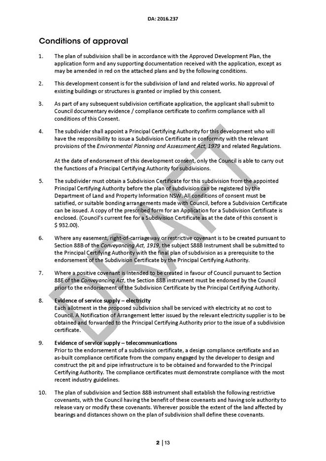
Condition 17
has been placed on the Draft Consent to provide for these requirements (see
Attachment 3).
Biodiversity
The property has environmental constraints with a prominent
riparian corridor running along the eastern boundary and a gully to the south.
This land forms part of a larger catchment with valuable vegetation and
habitat. The DA was lodged with a flora and fauna assessment prepared by Local
Environmental Solutions, December 2015.
The impact of the subdivision on the biodiversity of the
site has been assessed and amendments made to the original subdivision design
to better reflect the inherent constraints of the site. Two battle axe
allotments that were originally located over the existing gully have been
removed and a right of access across the riparian land deleted from the
original subdivision proposal.
The scale of the subdivision has therefore been reduced from
14 to 12 allotments in response to the site constraints.
Lot design
The latest design has consolidated the more restricted land
into two parcels and includes an unusual horseshoe shaped allotment (Proposed
Lot 11) and a larger lot to the north that is being consolidated with land
fronting Redfern Close (Proposed Lot 12). These allotments have been designed
to contain all of the constrained land, including the riparian areas and
existing gully, all of which will remain in the ownership of ‘Bobbins Transport’.
A restriction has been placed over this land to reinforce
these requirements to provide for its future protection (see Condition 10 of
the Draft Consent).
Policy – Procedure 3.01.4 Councillor/ Staff – Determination of
Development Applications
The Procedure applies to any DA lodged where a Councillor or
senior level employee is connected to the application, as an applicant, owner,
employee or relative. The Procedure in those circumstances requires referral of
the DA to Council for consideration and determination.
This DA has therefore been referred to Council as Cr Russell
Fitzpatrick is an employee of Bobbins Transport Pty Ltd.
Submissions
The DA was placed on exhibition for a period of 14 days from 12 July 2016 until 26 July 2016. One
submission was received.
The key issues raised in this submission are discussed below,
followed by Council officer comment.
A copy of the submission will be available at the Council
meeting.
Noise and
amenity
Building
the lots will be noisy enough, but the potential to have greater noise level
from potentially 14 different industries will destroy any peace and quiet that
I may have left, as well as continue the trend of devaluation that Bobbins has
already started. We have endured noise 24 hours a day from the trucks at
Bobbins yard and spotlights shine directly into our bedroom window all night.
Comment:
The zoning permits a range of industrial land uses that
would be subject to future assessment taking into account such matters as light
spill and noise generation.
Subdivision of the land in itself would not necessarily
increase the cumulative impact on the area in terms of amenity. This impact is
more likely to depend on the type of industrial activity, intensity of use and
management of these future land uses.
A meeting was held with the objectors to discuss their
concerns that relate primarily to the existing business, hours of operation,
noise generation and light spill. Specific issues were raised with the braking
of trucks along Mount Darragh Road, the sound from reversing alarms and light
spill. These are issues that have been conveyed to the applicant and will be
addressed through the education of staff in terms of driver behaviour and
management of the site.
Lifestyle and
environment
Impact
on the river and ambience of surrounding areas, that is still a large draw to
bringing residents to the south coast, with industrial waste, sewerage, and
building paraphernalia.
The
value of my property in regard to rural lifestyle living has already decreased
in value because of this industry. As you can imagine, 14 more lots would
destroy our rural lifestyle in South Pambula. It would make rural living
non-sustainable in this area. This large subdivision is too close to rural and
residential areas.
Comment:
This site forms part of a larger industrial area located on
the southern side of Mount Darragh Road at South Pambula, bordered by forestry
land to the south-west, environmentally zoned land immediately to the south and
rural land to the north.
There is a dwelling (house) to the south and another on
industrial land immediately to the west. The only rural residential land is
located on the northern side of the Pambula River and any future development of
this land is limited by a 120ha lot size. A flora and fauna assessment was
lodged with the DA and provision has been made for the preservation of the
existing riparian corridor and gully within the site.
The overall lot yield has also been reduced from 14 to 12
lots.
Conclusion
The original design has been amended to reflect the natural
constraints of the site. The matters raised in the submission have been
reviewed within the context of the surrounding landscape and industrial zoning
of the land.
This subdivision for the creation of 12 industrial
allotments is recommended for approval, subject to the conditions outlined in
the Draft Consent attached to this document.
Attachments
1. Locality
Plan
2. Proposed
Subdivision
3. Draft
Consent
Recommendation
1. That
Development Application 2016.237 for a 12 Lot Industrial Subdivision of Lot
71 DP 1074392 and Lot 341 DP 1222135 at 243 Mount Darragh Road and 12
Redfern Close, South Pambula be approved subject to the conditions contained
within the Draft Consent attached to this report.
2. That
the author of the submission be notified of Council’s determination.
|
|
Council
|
14 December 2016
|
|
Item 9.1 - Attachment 1
|
Locality Plan
|
|
Council
|
14 December 2016
|
|
Item 9.1 - Attachment 2
|
Proposed Subdivision
|
|
Council
|
14 December 2016
|
|
Item 9.1 - Attachment 3
|
Draft Consent
|
|
Council 14
December 2016
|
Item 9.2
|
9.2. South Bega
Industrial Lands Planning Proposal - Results of Public Exhibition
This report
details the results of the public exhibition of the South Bega Industrial Lands
Planning Proposal and recommends adoption of the exhibited zonings.
Director Planning and Environment
Background
The purpose
of this report is to detail the outcomes of the public exhibition of the
Planning Proposal for various properties at South Bega and recommends adoption
of the exhibited zonings as amendments to the Bega Valley Local Environmental
Plan 2013.
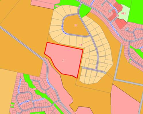
The subject
land is part of an overall plan to encourage and release more industrial land
at South Bega, to support employment and business opportunities. The land was
originally exhibited as R5 Large Lot Residential, however after considering
submissions from landowners, Council resolved to re-consider the land for
industrial uses.
The proposed
Light Industrial Zone (IN2) adjoins existing industrial zoned properties with a
focus on light industrial uses. Council’s South Bega water storage tanks
and pump stations are located in the middle of the proposed IN2 Zone and have
been incorporated into a Special Purposes Zone – Infrastructure (SP2).
There is a
local heritage item of significance abutting the subject land namely the Old
Bega Hospital (Crown Land) zoned ‘RE2 Private Recreation’, that
will remain unchanged.
At the
meeting of 8 June 2016 Council considered a report to un-defer and then re-zone
the subject land as IN2 and SP2 and resolved;
“1. That
Council resolves to zone the following land; Lots 1, 2, 3 DP 1077434, Lot
242 DP 750190, Lot 297 DP 728021, Lots 2381 & 2382 DP 873277, Lots
7005 & 7006 DP 1057325, Lot 2492 DP 732066, Lot 250 DP 750190, Lot 1
DP 502251 Newtown Road, Boundary Road and East Street, Bega in accordance with
the Planning Proposal included as Attachment 1 to this report.
2. The
Planning Proposal be lodged with the NSW Department of Planning and Environment
for Gateway determination.”
Council
received a Gateway Determination for the planning proposal on 13 July 2016 from
NSW Planning and Environment and delegation of the functions of the Minister
for Planning and Environment to make the Plan. In accordance with the Gateway
Determination, the planning proposal was placed on Public Exhibition for 28
days from 29 July to 26 August 2016.
The
exhibition of the planning proposal included notification on Council’s
website, in local newspapers, in writing to affected and adjoining landowners.
Three government agencies were also informed of the proposal – the Rural
Fire Service, Office of Environment and Heritage and the Roads and Maritime Services.
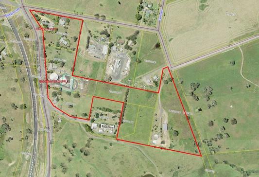
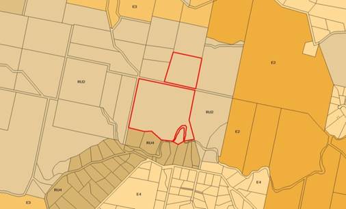
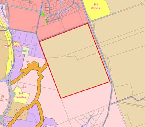
Figure 1: Subject Land – South Bega
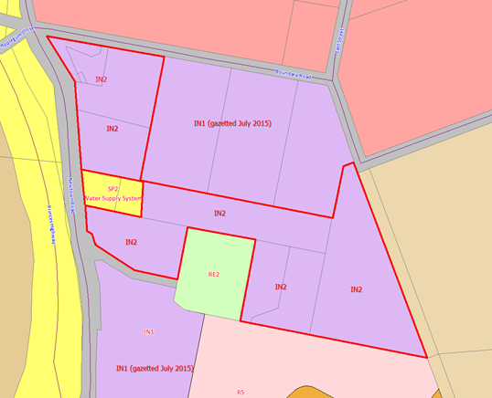
Figure 2: Proposed zonings – South Bega
Submissions:
Two (2) public submissions were made in
relation to the re-zoning proposal. All issues raised during the exhibition
process have been summarised in the table below.
|
Concern
|
Staff Response
|
|
1. Old Bega
Hospital Reserve Trust - surrounding the Old Bega Hospital with industrial
buildings will be detrimental to the future amenity of the site and its
public use.
|
It is agreed inappropriate industrial building design
could adversely impact the current semi-rural landscape setting of the Old
Bega Hospital. Any future Development Applications for industrial buildings
will have to be assessed against clause 5.10 of the CLEP 2013 ‘Heritage
Conservation’ which includes development which impacts upon a Heritage
Item. Appropriate setbacks and materials and finishes of industrial buildings
will be two important criteria to assess.
|
|
2. Old Bega
Hospital Reserve Trust - re-zoning to industrial land is adverse to the extensive
surrounding residential lands and Bega residential growth corridor.
|
It is not agreed an expansion of industrial land as
opposed to Large Lot residential will significantly compromise the further
urban expansion of Bega in a southwards direction. There are currently
extensive areas of existing R2 (Low Density Residential) urban land zoned to
the north and north east of this site which have not yet been developed.
|
|
3. L.K.Blacker
& Sons Pty Ltd - The proposed rezoning of the subject land to light industrial
and not general industrial is very limiting in the nature of permitted
development. As an example it would exclude a new car sales dealership.
|
‘Vehicle sales’ are not prohibited in the
Light Industrial Zone (IN2). ‘Vehicle sales’ are a type of ‘retail
premises’ which is a use permitted with consent.
In addition, it is considered that IN2 is:
· a more appropriate zoning for areas immediately
surrounding the Old Bega Hospital, and
· a more appropriate zoning for the prominent and elevated
gateway land next to the old highway.
|
Agency
Consultation as required by the Gateway Determination:
|
Agency
|
Response of Agency (21 days to
comment)
|
|
Rural Fire Service
|
No response.
|
|
Office of Environment and Heritage
(OEH)
|
No objection. OEH stated
there is the potential for Aboriginal heritage values to occur across the
subject site.
|
|
Roads and Maritime Services (RMS)
|
Require more information.
RMS has requested a Traffic Impact Study (TIS) to properly assess the
impact of the re-zoning. It is not possible at this stage to properly obtain
any meaningful data on truck /car movements from this 10.7 hectares of land.
The future type and density of industrial land use is unknown. Any concerns
from RMS about potential increase in truck / car movements impacting upon the
Newtown Road, Princes Highway intersection will be appropriately assessed at
any subsequent Development Application stage.
|
Conclusion
Public and
agency consultation of the Planning Proposal has been completed. Following a
review of the issues in the submissions relating to the re-zoning to Industrial
Land, it is considered no changes are necessary to the Planning Proposal as
exhibited. The addition of further IN2 (Light Industrial) lands to the Bega
area will help address identified demand for industrial and enterprise lands in
the broader catchment.
It is
recommended Council proceed to finalise the Plan in accordance with the
delegations issued by the Minister for Planning and Environment under Section
59 of the Environmental and Planning Act 1979. No amendments to the
provisions of the Planning Proposal are recommended.
Attachments
Nil
|
Recommendation
1. That
Council resolves to zone the following land Light Industrial (IN2); Lots 1,
2, 3 DP 1077434, Lot 242 DP 750190, Lot 297 DP 728021, Lots 2381 &
2382 DP 873277, Lots 7005 & 7006 DP 1057325, Lot 2492 DP 732066, Lot
1 DP 502251 in accordance with Figure 2 of this report.
2. That
Council resolves to zone the following land Special Purposes (SP2) –
Infrastructure; Lot 250 DP 750190.
3. That
Council proceed to finalise the amendment to Bega Valley Local Environmental
Plan 2013 (Amendment No. 21) in accordance with the delegations issued by the
Minister for Planning and Environment under Section 59 of the Environmental
Planning and Assessment Act 1979.
|
|
Council 14 December 2016
|
Item 9.3
|
9.3. Finalisation
of Amendment to Local Environmental Plan 2013 - Bournda Downs, Sapphire Coast
Drive, Wallagoot
This report
details the results of the public exhibition of the Bournda Downs Planning
Proposal and recommends adoption of the exhibited zonings.
Director Planning and Environment
Background
The purpose
of this report is to detail the outcomes of the public exhibition of the
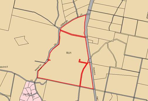
Planning Proposal for the Bournda Downs property on Sapphire Coast Drive, and
recommends adoption of the exhibited zonings and lot sizes as amendments to the
Bega Valley Local Environmental Plan (BVLEP) 2013. The land is currently a
‘Deferred Matter’ under BVLEP 2013. The objective of the Planning
Proposal is to rezone Lots 34 DP 875572, Lot 42 DP 815711 and Lot 85 DP 750194
Sapphire Coast Drive, Wallagoot to a combination of Environmental and Rural
Landscape zones.
At the
meeting of 8 June 2016 Council considered a report to un-defer and then re-zone
the subject land as E4, E3 and RU2 and resolved;
“1. That
Council resolves to zone Lots 34 DP 875572, Lot 42 DP 815711 and Lot 85 DP
750194 Sapphire Coast Drive, Wallagoot in accordance with the Planning Proposal
included as Attachment 1 to this report.
2.
The Planning Proposal be lodged with the NSW Department of Planning and
Environment for Gateway determination.”
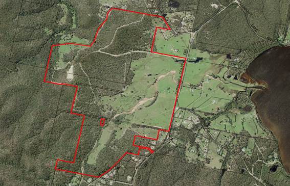
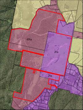
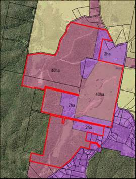
Figure 1: Subject Land – Bournda Downs
Council
received a Gateway Determination for the Planning Proposal on 13 July 2016 from
NSW Planning and Environment and delegation of the functions of the Minister
for Planning and Environment to make the plan.
In
accordance with the Gateway Determination, the Planning Proposal was placed on
public exhibition for 14 days from 29 July to 26 August 2016. The exhibition of
the planning proposal included notification on Council’s website, in
local newspapers, and in writing to affected and adjoining landowners. Four (4)
government agencies were also consulted during the exhibition of the Planning
Proposal and their comments are summarised further below.
SUBMISSIONS
Nine (9)
public submissions were made in relation to the re-zoning proposal. The
submissions are summarised in the table below.
|
Concern
|
Staff Response
|
|
1. Will create major
flooding and access issues to Lots 311 & 312 DP 116411003
|
This is an existing condition in the vicinity of
Wallagoot Lake which will not change as the up-catchment area is to be partly
zoned E4 and partly zoned E3, both with limited development potential.
|
|
2. Yellow-bellied
Glider (YBG) habitat will disappear if hill forests are removed
|
Most of this forest is regrowth on the edge of farming
land and is unlikely to contain hollow bearing or YBG habitat tree such as
Bloodwoods.
A full flora and fauna assessment would be required in
any future subdivision proposal.
|
|
3. Monks Creek
health threatened by sewer waste
|
Clause 6.6 of the BVLEP 2013 has provisions which are
designed to protect the health of waterways which would be considered as part
of any future development application for subdivision.
|
|
4. Loss of forest
cover and impact upon trees and fauna
|
The proposed E4 zoned land has been located to minimise
vegetation loss in all instances. Each of the three proposed E4 precincts has
a small proportion (approx. 20%) of land that is forested.
It is acknowledged that some of this forested land may be
impacted by future Asset Protection Zones if required by the Rural Fire
Service at the time of subdivision.
|
|
5. Detrimental
impact upon adjoining Bournda NP which hosts endangered breeding birds
|
The amount of potential vegetation loss is not considered
to be of an order to threaten the breeding habit of endangered birds within
the Bournda National Park.
|
|
6. Inappropriate
zones (E3 and E4 ) over forested land
|
Each of the three E4 precincts has a small proportion
(approx. 20%) of land that is forested. It is acknowledged that some of this
forested land may be impacted by future Asset Protection Zones.
14 Hectares of forested/regrowth land is proposed under
E4 Environmental Living. The proposed E4 zoned land has been located to
minimise vegetation loss in all instances.
|
|
7. Dangerous access
off Sapphire Coast Drive
|
The final location of any intersection would be assessed
at the time of lodgement of a Development Application for subdivision.
However initial considerations confirm that there is adequate sight distance
available.
|
|
8. Koala habitat not
addressed in PP
|
The land in question is not considered core koala
habitat, therefore a response to the SEPP 44 ‘Koala Habitat
Protection’ question in the Planning Proposal does not apply. Only 14
Hectares of forested land is under the more intensive development zone of E4.
Core koala habitat means an area of land with a resident population of
koalas, evidenced by attributes such as breeding females (that is, females
with young) and recent sightings of and historical records of a population.
Any future development application for subdivision of the
land will require a detailed flora and fauna investigation.
It is noted the Office of Environment and Heritage have
not objected to the rezoning.
The original 1 (c) zoning of the land would have
permitted over 120 lots to be developed on the land. This proposed
rezoning significantly reduces the environmental impact whilst allowing some
development potential.
|
|
9. The impact of
Asset Protection Zones over 37 lots is too great
|
It is acknowledged that some proportion of the 14
Hectares of forested lands in the E4 zones may require some vegetation loss
for the establishment of Asset Protection Zones.
|
|
10. No Aboriginal heritage areas
have been mapped
|
Any future development application will
require an Aboriginal cultural heritage assessment.
|
|
11. Acid Sulphate soils exist on
the property
|
The Acid Sulphate Soils exist only on a very minor part
of the Monks Creek bed close to Sapphire Coast Drive.
This land is proposed to be Rural Landscape (RU2) and would
be excluded from any building envelopes.
Bega Valley Local Environmental Plan 2013 specifies
strict protocols for any development over Acid Sulphate Soils.
|
|
12. Increase in population
threatens the health of Wallagoot Lake and the Catchment surrounding it,
especially increased sedimentation.
|
This Planning Proposal significantly reduces development
potential from a previous proposal of more than 120 lots to the current
proposal of 37 lots.
The impact of likely earthworks is considered very
minimal. Increased sedimentation arising from future road construction for
housing development could be adequately controlled by an erosion control
management plan (as per standard conditions on any DA for subdivision).
|
Agency Consultation as required by the Gateway
Determination:
|
Agency
|
Response of Agency (21 days to
comment)
|
|
Rural Fire Service
|
No objection. Noted that
western and northern portions (proposed zone E3) of the site may have
constrained access.
|
|
Office of Environment and Heritage
|
No objection. Any future
subdivisions must include a masterplan delineating building envelopes, any
associated infrastructure and asset protection zones. Need to adopt the
principles of avoiding, mitigating and offsetting any impacts to
biodiversity.
Any future development application
will require a comprehensive Aboriginal cultural heritage assessment.
|
|
Roads and Maritime Services
|
No objection. It was noted
that the subdivision exits onto a Council managed road.
|
|
Department of Industry –
Resources and Energy
|
No objection. Noted that the
existing quarry in the proposed E3 zone no longer has existing use rights.
|
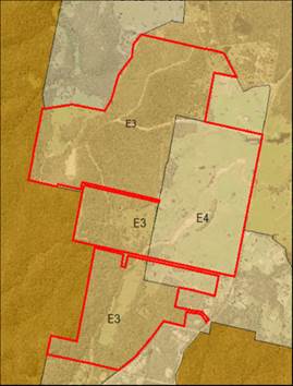
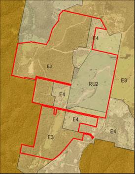
Exhibited Zones (2010) Proposed
Zones (2016)
Exhibited Lot Size (2010) Proposed
Lot Size (2016)
Figure 2: Proposed zonings and lot sizes – Bournda
Downs
·
Conclusion
Public and
agency consultation of the Planning Proposal has been completed. Following a
review of the issues in the submissions relating to the proposed zonings of E4,
E3 and RU2, it is considered no changes are necessary to the Planning Proposal
as exhibited.
It is
recommended Council proceed to finalise the Plan in accordance with the
delegations issued by the Minister for Planning and Environment under Section
59 of the Environmental and Planning Act 1979.
Attachments
Nil
|
Recommendation
1. That
Council resolves to zone Lots 34 DP 875572, Lot 42 DP 815711 and Lot 85 DP
750194 Sapphire Coast Drive, Wallagoot to a combination of
Environmental Living (E4), Environmental Management (E3) and Rural Landscape
(RU2), with minimum lot sizes of 2ha and 40ha being applied in accordance
with Figure 2 of this report.
2. That
Council proceed to finalise the amendment to Bega Valley Local Environmental
Plan 2013 (Amendment No. 22) in accordance with the delegations issued by the
Minister for Planning and Environment under Section 59 of the Environmental
and Planning Act 1979.
|
|
Council 14 December 2016
|
Item 9.4
|
9.4. Finalisation of Amendments to Local Environment Plan 2013 - Undefer
Various Sites
This report details the results of
the Public Exhibition of the Planning Proposal seeking to “Un-defer Seven
Deferred Sites” across the Bega Valley Shire and recommends adoption of
the exhibited zonings and lot sizes.
Director Planning and Environment
Background
Council
officers have been preparing a series of Planning Proposals to finalise sites
identified as ‘Deferred matters’ under Bega Valley Local
Environmental Plan 2013 (BVLEP 2013).
Following
ongoing discussions with the Department of Planning and Environment, and
further investigation by officers, a Planning Proposal was prepared for seven
sites subject to this report. The Planning Proposal recommended proceeding with
the zoning and lot sizes as publicly exhibited in the draft Bega Valley Local
Environmental Plan 2010 (draft BVLEP 2010) for each of the seven sites.
On 20 July
2016, Council considered a report on the draft Planning Proposal and resolved
as follows:
“That the seven sites considered
within this report be “un-deferred” and the zoning and lot sizes
revert to those exhibited in draft Bega Local Environmental Plan 2010 as
follows:
a) Lot
445 DP 1061010, Lochview Farm Road, Lochiel
Rural Landscape Zone (RU2) with a Minimum Lot Size of 120 Hectares
b) Lot
4892 DP 1103062, Woodlands Lane, Bald Hills
Rural Landscape Zone (RU2) with a Minimum Lot Size of 120 Hectares
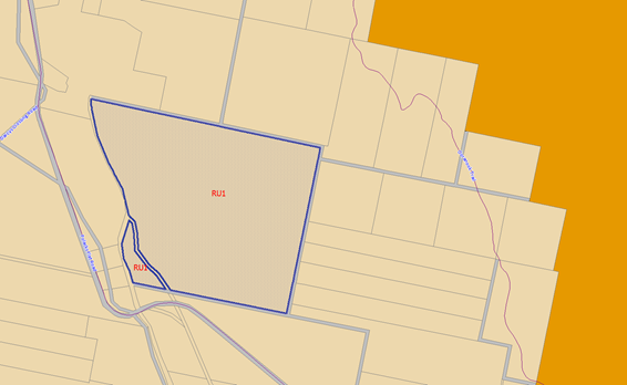
c) Part
Lot 1 DP 1164038, Lots 1 & 2 DP 1101354, Tathra Road, Bega
Primary Production Zone (RU1) with a Minimum Lot Size of 120 Hectares
d) Lots
1 – 5 DP 455379, Palestine Road, Eden
Large Lot Residential Zone (R5) with a Minimum Lot Size of 5,000m2
e) Part
Lot 600 DP 1193160, Mirador Drive, Merimbula
Low Density Residential Zone (R2) with a Minimum Lot Size of 2,000m2
f) Lot
5 DP 1021345, Princes Highway, Wolumla
Primary Production Zone (RU1) with a Minimum Lot Size of 120 Hectares
g) Lot
3 DP 750226, Polacks Flat Road, Bemboka
Primary Production Zone (RU1) with a Minimum Lot Size of 120 Hectares.
On 6
September 2016, the Department of Planning made a Gateway Determination to
allow the proposal to be publicly exhibited for a period of 28 days as shown in
the following figures.
a) Lot
445 DP 1061010, Lochview Farm Road, Lochiel

b) Lot
4892 DP 1103062, Woodlands Lane, Bald Hills
c) Part
Lot 1 DP 1164038, Lots 1 & 2 DP 1101354, Tathra Road, Bega
d) Lots
1 - 5 DP 455379, Palestine Road, Eden
e) Part
Lot 600 DP 1193160, Mirador Drive, Merimbula
f) Lot
5 DP 1021345, Princes Highway, Wolumla
g) Lot
3 DP 750226, Polacks Flat Road, Bemboka
Consultation
The Planning
Proposal was exhibited for a period of 28 days by notifying the affected
property owners and adjacent landowners. Notices were also placed in all local
newspapers across the Bega Valley Shire.
No
submissions were received by Council during the exhibition period.
The Gateway
Determination required Council to refer the Planning Proposal to the Rural Fire
Service with no objections raised.
Conclusion
Following
the exhibition period and consideration of the submissions, it is recommended
the seven sites in this report revert to the originally exhibited zonings and
minimum lot sizes (as per draft BVLEP 2010).
Some of
these sites may be revisited in the future as part of the development of further
land use strategies by Council for enterprise lands, residential growth areas,
small lot agriculture and rural living. In the meantime, individual land owners
have the opportunity to submit a Planning Proposal if they wish to pursue a
rezoning.
Attachments
Nil
Recommendation
1. That
the seven sites considered within this report be “un-deferred”
and the zoning and lot sizes revert to those exhibited in draft Bega Local
Environmental Plan 2010 as follows:
a) Lot
445 DP 1061010, Lochview Farm Road, Lochiel
Rural Landscape Zone (RU2) with a
Minimum Lot Size of 120 Hectares
b) Lot
4892 DP 1103062, Woodlands Lane, Bald Hills
Rural Landscape Zone (RU2) with a
Minimum Lot Size of 120 Hectares
c) Part
Lot 1 DP 1164038, Lots 1 & 2 DP 1101354, Tathra Road, Bega
Primary Production Zone (RU1)
with a Minimum Lot Size of 120 Hectares
d) Lots
1 – 5 DP 455379, Palestine Road, Eden
Large Lot Residential Zone (R5)
with a Minimum Lot Size of 5,000m2
e) Part
Lot 600 DP 1193160, Mirador Drive, Merimbula
Low Density Residential Zone (R2)
with a Minimum Lot Size of 2,000m2
f) Lot
5 DP 1021345, Princes Highway, Wolumla
Primary Production Zone (RU1) with a Minimum
Lot Size of 120 Hectares
g) Lot
3 DP 750226, Polacks Flat Road, Bemboka
Primary Production Zone (RU1) with
a Minimum Lot Size of 120 Hectares.
2. That
Council proceeds to finalise the amendments to Bega Valley Local
Environmental Plan 2013 (Amendment No. 23) in accordance with the delegations
issued by the Minister for Planning and Environment under Section 59 of the
Environmental Planning and Assessment Act 1979.
|
|
Council 14 December 2016
|
Item 9.5
|
9.5. Entrance
Management Policies for BVSC Lakes and Lagoons
The NSW Office of Environment and Heritage requires
councils to develop ‘Entrance Opening Policies’ for any
Intermittently Closing and Opening Lakes or Lagoons (ICOLLs) that require
mechanical intervention. Policies have been developed through community and
stakeholder consultation, surveys, assessments and a comprehensive Review of
Environmental Factors, for each of the lakes and rivers that Council seeks to
open. This report recommends the approval of policies to guide the entrance
management of: Wallaga Lake; Cuttagee Lake; Bega River; Wallagoot Lake; Back
Lake; and Curalo Lagoon. Although a draft Policy has also been prepared for
Wonboyn Lake, further consultation of stakeholder groups is required. A
separate report for Wonbyon Lake will be submitted when the consultation
process has been completed.
Director Planning and Environment
Background
The State Government, through the NSW Office of Environment
and Heritage (OEH) requires councils to prepare ‘Entrance Management
Policies’ for all estuaries, coastal lakes and lagoons that are
artificially opened and/or manipulated. Although there is no specific
legislation which covers the occasional opening of these coastal water bodies,
OEH has developed the NSW Entrance Management Policy model.
The advantage of the NSW Entrance Management Policy model is
that it provides certainty for all affected stakeholders and the wider
community of when, where, how and under what conditions estuaries, coastal
lakes and lagoons will be artificially opened. The proposed BVSC policies
follow this model and have been reviewed and approved by the relevant
government agencies. This eliminates the current need to seek approvals from
the various authorities each and every time Council needs to open an estuary.
This will increase Council’s responsiveness, improve consistency and
afford Council certainty regarding entrance management operations.
The Review of Environmental Factors (REF) and draft policies
define principles for the timing and location of the openings, required lake
heights, access arrangements and other special considerations including the
protection of Aboriginal Cultural Heritage and threatened species habitat
conservation.
The draft policies reflect the following longer term
entrance opening principles:


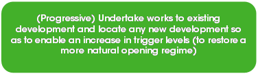


Figure 1: ICOLL Entrance Management Philosophy
The entrance
opening policies proposed were the subject of Councillor briefings in July 2016
and early December 2016.
Current opening procedures
The proposed
policies formalise the current informal opening processes Council has followed
for many years with respect to carrying out the artificial opening of the
lakes. Council currently uses a set Australian Height Datum (AHD) lake level as
a trigger to open the ICOLLs, that is based on the heights of significant public
or Council approved private assets around the lake foreshores. The opening
heights proposed in the draft policies are based on the existing entrance
opening heights and are listed below:
|
ICOLL
|
Opening
Height (AHD)
|
|
Wallaga Lake
|
1.25m
|
|
Cuttagee Lake
|
1.8m
|
|
Bega River
|
1.36m
|
|
Wallagoot Lake
|
1.4m
|
|
Back lake
|
1.4m
|
|
Curalo Lagoon
|
1.2m
|
The closure of a river or lake
entrance mouth is a natural occurrence. While there are obviously many
‘built’ physical impacts in the catchment (e.g. bridges, causeways,
land clearing and sedimentation etc) the closure of an estuary entrance remains
a natural process that occurs in the majority of estuaries on the far south
coast.
The State
Government’s Policy for estuary entrance management aims to ‘where
possible, minimise entrance manipulation to mimic a more natural opening
regime’. The intent of this policy is to allow the lake to experience
a variety of water levels, including periods of elevated water levels, to
ensure that fringing wetlands, saltmarsh and swamp communities receive periodic
inundation which is a vital part of their life cycles (e.g. for fish).
An example of an
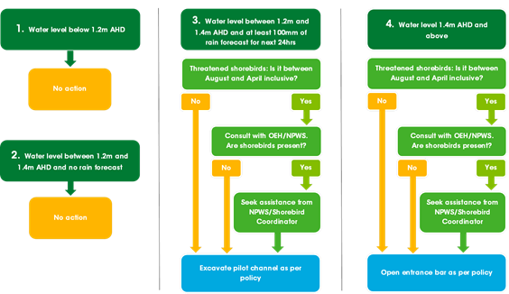
opening decision flow chart is provided below for Back Lake (Merimbula):
Key factors for a successful lake opening:
There are a
number of key factors that result in successful lake or river entrance
openings.
1. Amount
of water in the lake and flowing in from the catchment following the opening.
The more water in the lake prior to the opening, the more
effective the opening will be and longer is the entrance likely to remain open.
Even a few extra centimetres of water across the lake is a significant amount
of water in volume. This volume creates greater 'head pressure’ or force,
which the water has to ‘blow out’ the sand in the entrance. If
large amounts of water continue to flow into the lake following the opening
this will also assist in achieving a successful opening.
2. The
tide
The aim is to undertake the final opening for the top of the
high tide. This is to ensure that as the tide drops the tidal drag helps
‘suck’ the water out of the lake and scour the entrance of sand. If
a large flood is occurring the tide becomes less important as there is
generally enough force from the floodwaters to ensure a successful opening.
However, it is important to note the timing on the day of any potential opening
will likely be governed by the tide and available daylight.
3. The
ocean swell – height and direction
If there is a large swell running on the ocean and it is hitting
the beach where the opening is occurring this can hamper the excavation of the
sand and make it quite dangerous for the Council officers or contractors
involved. Large seas can move huge amounts of sand and can very quickly start
to shoal the entrance after it has been opened. Lake openings often coincide
with large storms or East Coast Lows that often result in large seas and
increased storm surge. At times, the entrance may be open, but due to the
elevated level of the ocean and the large swell, there is still a hydraulic
closure of the entrance as the water cannot escape from the entrance (as seen
at Back Lake during the June 2016 East Coast Low storm event). This can have serious
implications for the flooding of low lying assets around the lakes. When this
occurs there is little Council can do until the opening conditions improves.
As such when these circumstances exist,
Council will avoid opening the river or lake if there are dangerously large
swells occurring. Despite this, if there is a flooding emergency Council will
review the safety implications to officers and contractors and open if deemed
feasible and safe.
Issues
Legal
To date Council’s entrance opening processes have been
‘ad hoc’ and without formalised policies in place. In many
instances openings have been organised in flood circumstances whilst multiple
agency approvals are still being sought. Council’s actions have been
legal, but the process has proven difficult for Council and the government
agencies. This is particularly the case when openings are required on an
emergency basis and where delays can have serious impacts on public safety
(road closures) and in the flooding of assets.
The proposed policy documents provide the legal framework
for Council to undertake the mechanical works through the provision of the
comprehensive Review of Environmental Factors (REF). The draft Policy documents
and REF are detailed and comprehensive and are available on Council’s web
pages. Hard copies will also been tabled at the Council meeting.
While Council is the proponent for these works, it is also
the determining authority. The REF has been prepared in accordance with the
requirements of the Environmental Planning and Assessment Act 1979 and
has been approved by Council’s Planning Services Manager. In addition to
the approval of the REF, additional required Agency approvals have been or are
currently being sought.
Formal approvals / permits required have been included for:
· Aboriginal
Heritage Impact Permit (AHIP) to allow machinery to traverse areas of potential
cultural heritage significance.
· Department
of Primary Industries (Fisheries) letter of support
A final
government Licence to occupy Crown Land to perform works such as access and
excavation has been delayed. This Licence to occupy Crown Lands (under the Crown
Lands Act 1989) will be incorporated into the REF documentation when it is
Gazetted and issued.
Economic
The
management of lake and river openings across the Shire is a key Council
function that relates to public safety and the protection of a range of public
and private assets including dwellings, roads, and sewer and water
infrastructure. The disruption to critical services such as water and sewer,
transport and access and privately owned assets is acknowledged as having a
significant economic impact.
Policy
If adopted, it is proposed these policies will be in place
until they are reviewed in five (5) years from the date of adoption. The
approval, organisation and operational functions of lake openings sits with
Council’s Environmental Services Team and these policies will be the key
guiding documents to facilitate ICOLL openings into the future.
The proposed policies follow the long established trigger
heights that have been developed over many years. The draft policies and REF
document these accepted trigger levels and formalise all the studies and
approvals required to meet the government model for artificial openings of
lakes, lagoons and rivers. The policies provide greater consistency and allow
for a simplified approval process.
Operational
Plan
The adoption of the Entrance Management Policies will result
in a formal and documented approach to the management of entrance openings. The
defined process will lead to savings in Council officer consultation and in
gaining approvals from government agencies each and every time that a lake or
river opening is required.
The development of the Entrance Management Policies meets
strategic action S1.2.1 (Administer the Coastal Zone Management Program) of the
2015-16 Operational Plan, that outlines undertaking a review of entrance
management policies and protocols. The policies will be the key strategic
document for managing estuary entrances over the next 5 years.
Environmental
/ Sustainability
The Entrance
Management Policies aim to achieve a reasonable balance between minimising the
flooding of low lying assets and allowing water levels to reach a level
conducive to an effective opening and which is beneficial for the environment.
The policies also suggest a longer term approach of progressively raising or
relocating key low lying assets into the future to allow higher water levels
and a more natural opening regime. This is a key factor to consider as Council
progressively works towards adapting to the impacts of weather extremes and sea
level rise in and around our coast and estuaries.
For example,
the current predicted natural opening height for most of our ICOLLs is
somewhere between 2m and 3m AHD. Most of the Shire’s ICOLLs are opened at
approximately the 1.4m AHD level, which for some estuaries is roughly half of
the natural opening height. The consistent opening of ICOLLs at these set
levels means that the ecologically important transitional vegetation such as
mangroves, saltmarsh and other coastal Endangered Ecological Communities are
not inundated at their natural levels. This has caused some changes to these
key ecological environments and the communities they support, and is one of the
main reasons to consider the raising of low-lying built assets into the future
so as to allow ICOLLs to behave more naturally.
Asset
The key objective for developing Entrance Opening Policies
is to determine an opening height that allows the maximum amount of water to
fill the estuary without flooding or inundating major public or approved
private assets whilst also protecting public safety. Due to some historical
planning and development decisions, Council does have legacy issues in some of
the low lying areas around lake fringes. During the development of the draft
policies, all low lying assets around each of the lake foreshores were surveyed
and heights documented. This is a key data set for future asset management.
The key assets impacted by ICOLL inundation are: roads; golf
courses; sports grounds; causeways; bridges; board walk;, caravan park sites;
car parks; and private properties. With the heights of all these assets now
known, over the long term Council can work towards progressively raising these
assets, where feasible, to allow the ICOLLs to assume a more natural opening
regime while also adapting to rising sea levels.
If Council undertakes the raising of public assets over time
as part of its routine asset replacement program as suggested in the policies,
impacts on Council’s Budget can be minimised. Major projects to raise
significant assets such as sports grounds or roads will require long term
planning and resourcing.
Social
/ Cultural
Some areas
of Aboriginal cultural heritage significance have been discovered on the access
tracks used by the machinery to open the ICOLLs. As a result, a full
Archaeological Assessment was conducted for each access path used. Although
little high cultural significance was found, some entrance tracks required an
Aboriginal Heritage Impact Permit (AHIP).These Permits have been issued and
included in the opening process documents. This ensures Council has performed
its due diligence should anything of cultural significance be uncovered during
machinery access to the opening area.
Consultation
Community and stakeholder consultation has been a key
element in developing these policies. Importantly, Council actively sought
broader community input into the policies. A series of drop-in sessions was
held at locations central to each ICOLL. A total of 5 community sessions were
held with sessions run in the afternoon and evening to allow opportunity for
after work drop-ins. The sessions were widely advertised on Council’s
social media streams, the local newspapers, radio and Council’s website.
Despite this broad effort there was surprisingly low attendance to most
sessions. A potential reason for this low attendance is that past opening
heights were only being formalised, and not changed.
Stakeholder engagement was also directly undertaken by
Council with OEH, National Parks and Wildlife Service, Department of Primary
Industries (Lands) and Department of Primary Industries (Fisheries). Each
agency provided detailed comments on the draft policies and REF. All government
agency stakeholders engaged in the process have been supportive of the
policies.
Financial
and Resources
The finalisation of the draft policies, Review of
Environmental Factors and Aboriginal Cultural Heritage report were completed by
officers or through consultants with appropriate expertise. This ensured a high
quality outcome that has met Council and agency requirements.
This work including all community
stakeholder sessions and approvals were funded by Council through the Environment
Levy (Special Variation) as detailed below.
|
Funding source
|
|
Amount
|
|
Environment
Levy (2015/16) – finalisation of draft Policies, REF and Aboriginal
Cultural Assessment
|
$
|
50
000
|
The annual entrance opening practices are
very weather dependent and as such the annual operational budget is highly
variable. Entrance opening and management expenses for 2016-2017 are estimated
at $15,000.
Conclusion
Council has
had a longstanding involvement in opening ICOLLs. Although there have not been
formal policies in place, Council has followed a rigorous approval and
operational process for each individual opening. With the experience and
knowledge gained from previous ICOLL management, the documented draft policies
now represent the best contemporary approach to ICOLL entrance management for
the unique estuaries in the Bega Valley Shire. They also provide certainty for
Council operations and help communicate clearly the process and approach to
entrance opening with the community.
Attachments
Nil
|
Recommendation
That
Council approve the Entrance Management Policies for: Wallaga Lake; Cuttagee
Lake; Bega River; Wallagoot Lake; Back Lake; and Curalo Lagoon as tabled and
the Policies be placed on Council’s website.
|
|
Council 14 December 2016
|
Item 9.6
|
9.6. DA No.
2014.430: Modification to Development Consent - Cattle Bay Marina Development
Director Planning and Environment
|
Applicant
|
Heinrich Ruiz de Roxas
|
|
Owner
|
Eden Resort Hotel Pty
Ltd (c/- Directors Heinrich Ruiz de Roxas and
Lu Lin Yong)
|
|
Site
|
Lot 1 DP 1138056, Lots 2
and 4 DP 1138056 and waterway area,
Cattle Bay Road, Eden
|
|
Zone
|
SP3 Tourist Zone (land
component) and Unzoned (waterway area)
|
|
Site area
|
1.668 hectares plus
waterway area
|
|
Proposed
development
|
Modification to
Development Consent 2014.430
|
Precis
An
application has been lodged with Council seeking to modify a number of specific
conditions detailed in Development Consent 2014.430. The Consent endorses the
construction of a marina development, having both a land and water based
component.
The full scope
of the proposed modification will be addressed in this report together with
comment and recommendations for Council’s consideration and
determination.
Background
The Southern
Joint Regional Planning Panel (SJRPP), on 1 December 2015 approved, subject to
terms and conditions, the staged construction of a 154 berth marina, associated
wave attenuator in the waters of Cattle Bay Eden and ancillary land based
carparking, administration offices and amenities. A Deferred Development
Consent was issued on 22 December 2015.
Description of the proposal
Council is
now in receipt of an application to modify the Consent, pursuant to Section
96(1A) of the Environmental Planning and Assessment Act 1979. The
application is accompanied by a detailed statement of environmental effects
which provides information on the subject land, the existing development
consent and the proposed modifications sought by the proponent.
In summary,
the proposed modifications include:
· Modification
to development contributions levied under Section 94A of the Environmental
Planning and Assessment Act 1979 and S64 of the Water Management Act 2000,
taking into account marina usage, site credits and the material public benefit
already provided by the proponent in dedicating the foreshore as a public
reserve.
· Modification
to delete conditions requiring the upgrading of Cattle Bay Road based on
engineering advice to the effect that the existing road network has a suitable
capacity and standard of construction to cater for the likely traffic
generating potential of the marina development.
· Modification
to conditions relating to the phasing of subsequent construction certificates
for the land based components of the development to facilitate an orderly and
efficient development process.
· Modification
to conditions relating to the provision of on-site carparking to account for
the staging of the marina development and to clarify the temporary nature of
the carpark.
· Modifications
to conditions on servicing and easements to delete the requirement for
telecommunication servicing of the water based component of the development and
to delete the requirement for permanent easements over the temporary location
of services to the land based component.
Subsequent
to the lodgement of the application to modify the Consent, the proponents
engaged with Council’s Development Advisory Panel on 22 September 2016 to
discuss the specific matters detailed in the application. Stemming from that
meeting, the proponent submitted a revised proposal in regard to the widening
of Cattle Bay Road, the allocation of credits relating to sewer headwork
charges, the treatment of sewage and the allocation of S94A contributions.
A copy of
the proponent’s Application to Modify is attached to this report as
Attachments 1-5.
Assessment of the proposal
The proposed
modifications have been subject to detailed assessment as follows:
Condition 11 – Section 94A Contribution
Condition 11
requires the payment of a S94A Contribution to the value of $55,000 as levied
at the time of the original approval, pursuant to the provisions of the Bega
Valley Section 94 and 94A Contributions Plan 2014. The proposed modification
seeks the deletion of the condition pursuant to Section 2.12 of the
Contributions Plan.
In support of
the current modification, the proponent has advised the following:
· The
Bega Valley Section 94 and 94A Contributions Plan 2014 allows for a variation
of contributions, where justified, and in particular where a site may have S94
credits from a previous use or a material public benefit is provided in lieu of
S94 monetary contributions. The proposed marina has justification for a
variation of S94 contributions on both these grounds, with the site having S94
credits and a material public benefit being provided by the proponent.
· The
site has S94 credits associated with the previous industrial use which exceeds
the marina contributions. The principle of the site and its previous industrial
use having credits for contributions is already established by Council in
relation to sewer and water contribution credits, and the same principle
applies to S94A contributions. The previous industrial use of the land had
approximately 200 full time workers onsite, and the marina will have in the
order of 5 full time equivalent jobs onsite, being a substantial reduction in
demand for public infrastructure.
· The
developer has already provided a substantial material public benefit in the
form of dedicating 0.6ha of foreshore to Council as a public reserve which
reasonably satisfies the S94A Contribution. The value of the foreshore land at
the time of dedication is estimated at over $1 million and substantially
exceeds the $55,000 S94A contribution.
· Should
Council take the position of maintaining Condition 11, then we request the
$55,000 in contributions be used towards roads in Eden including
Council’s proposal to widen and upgrade Cattle Bay Road on the grounds
the marina does not generate a demand for other community infrastructure in the
S94 plan on which the contributions would be spent.
Staff
Comment
The need to levy a contribution under the
Contributions Plan was addressed at the time of the original reporting to the SJRPP and was considered appropriate
by the Panel given the circumstances of the case. As reported by Council
officers at the time and as considered by the Panel, the proponent sought a
waiver of the contribution on the basis that:
· The
proponent had provided a material public benefit in the form of dedicating over
6,500m2 of prime water front land to Council as public reserve,
which has a value far in excess of the contribution payable.
· The
proposal, if approved, would secure lawful public access to the existing wharf
component of the marina which has a material public benefit which could be
credited against the contribution payable.
· The
marina does not generate any significant demand for infrastructure and
facilities nominated in the Plan.
At the time, it was considered the grounds on which
the proponent sought the waiver would not sustain or justify a variation to the
Contributions Plan on the basis that:
· No land
valuation report had been submitted in support of the nature and extent of the
waiver.
· The
dedication of the foreshore reserve (Lot 4 DP 113056) was required under the
Major Project Concept Approval (05_0032) for a mixed tourist and residential
development and that the marina development was a separate and distinct proposal.
From that
originally submitted and considered by Council and the SJRPP, the
proponent’s position has remained unchanged with the exception being, the
application of a credit based on the past industrial usage of the site.
The
Contributions Plan, in this instance, makes no provision for the application of
credits based on past land use. Also, the marina development would attract
additional investment and expenditure in tourism and marine related industries
and would contribute to recreational and lifestyle opportunities in the local
community and Shire generally. Accordingly, it would progressively generate a
demand for the provision of associated public infrastructure as identified by
the Contributions Plan.
The
proponent’s position seeking the allocation of any subsequent
contribution specifically to the widen and upgrade Cattle Bay Road is not
accommodated within the works schedules of the Contribution Plans and therefore
is not supported.
Staff
Recommendation
That Condition 11 be retained without amendment.
Condition 80 – Section 64 Water and Sewer
Headwork Contributions
Condition 80
requires the issue of a Certificate of Compliance under the Water Management
Act 2000 and the payment of monetary contributions for additional loads
generated by the marina on reticulated water supply and sewer networks.
The
condition notes the marina development has been assessed by Council as imposing
additional loads of 59.4 ETs for both water and sewer, which equates to a water
headworks contribution of $477,576.00 and sewer headworks contribution of
$668,606.40 (as calculated at the time of issue of the Consent).
Whilst the
proponent agrees with Council’s assessment in relation to additional
loading (59.4 ETs) on Council’s reticulated water supply, the
proponent does not agree with Council’s assessment in relation to the
additional loading (59.4 ETs) on the sewerage network. In support of the
proponent’s position, a detailed report prepared by Royal
Haskoning DHV dated 5 April 2016, accompanies the current Section 96
application. The report indicates the maximum potential sewer load that can be
generated by the marina development (with 2 mobile pump-out units) is
approximately 14 ETs.
In addition,
the proponent has drawn reference to the fact Council has previously
acknowledged that the site, given its past industrial use, enjoys a credit of
62.5 ETs in calculating sewerage network loads, which would equally apply in
the calculation of water supply loads.
The proponent
maintains that applying the above position would result in a credit balance of
3.1 ET (62.5 ETs – 59.4 ETs) for water and 48.5 ET (62.5 ETs – 14
ETs) for sewer which would off-set any applied calculations in assessing water
and sewer headwork contributions for the land based mixed tourist and
residential development, endorsed by the Major Project Concept Approval
(05_0032).
Given the
above, the proponent seeks a modification to Condition 80 which, if approved,
would read:
“A Certificate of Compliance under Division 5 of
Part 2 of Chapter 6 of the Water Management Act 2000 must be obtained prior to
the issue of a construction certificate.
Note: The development has been assessed as
imposing an additional load of 59.4 ET to the water supply system and 14 ET to
the sewerage network. The site with its previous industrial use has been
assessed as having sewer and water load credits of 62.5 ET. The marina
development will not be subject to monetary contributions for water and sewer
as the site credits exceed the additional loads generated by the marina.”
In addition,
the proponent has also acknowledged Council may resolve to retain Condition 80.
In that event, the proponent is seeking an amendment to the condition to
reflect the allocation of water and sewer headworks credits and the
introduction of a monitoring program to establish actual sewer discharge loads
over the first 12 months of operation of Stage 1 of the marina, for the purpose
of determining the sewer headworks credits remaining on the land or contributions
payable.
Accordingly,
the proponent is seeking a modification to Condition 80 which, if approved,
would read:
“A Certificate of Compliance under Division 5 of
Part 2 of Chapter 6 of the Water Management Act 2000 must be obtained prior to
the issue of a Construction Certificate.
Note: The calculation of sewer and water headworks
contributions is to take into account the following:
The development has been assessed by Council as
imposing an additional load of 59.4 ET to the water supply system and 59.4 ET
to the sewerage network. The land base has a sewer load credit of 62.5 ET and a
water load credit of 62.5 ET which can be used by the marina development and
taken into account in the calculation of sewer and water headworks
contributions for the marina. If sewer and water load credits are to be used by
the marina, the proponent will need to advise Council in writing at the time a
Certificate of Compliance under Division 5 of Part 2 of Chapter 6 of the Water
Management Act 2000 is obtained. The land base will then retain a balance of ET
credits for sewer and water load that are not used by the marina and can be
used in future development on the land base.
The actual sewer load generated by Stage 1 of the
marina is to be monitored over a period of 12 months and then taken into
account to adjust the balance of the sewer load credits on the land
accordingly.
The payment of any sewer and water headwork
contributions due will be calculated at the rate specified in Council’s
adopted fees and Charges at the time of payment.”
Staff
Comment
The need to
levy contributions under the Water Management Act 2000 was addressed at
the time of the original reporting to the SJRPP and was considered appropriate
by the Panel, given the circumstances of the case.
Council’s
acknowledgement of site credits is contained in correspondence to the proponent
dated 23 September 2013. The correspondence acknowledges a credit in
calculating sewerage network loads and applies to the land based mixed tourist
and residential development endorsed by the Major Project Concept Approval
(05_0032).
As part of
the original application, the proponent supplied a report from Royal Haskoning
DHV entitled “Cattle Bay Marina Water and Wastewater Servicing
Strategy” dated April 2015. This report calculated a water demand of
59.4 ET, or 0.37 ET/berth.
The Royal
Haskoning report also included a table listing Marina ETs used by other
councils and water corporations. The table included the rate used by SEQ Water,
Gold Coast City Council Area for a Marina (Transient Moorage), of 0.4
ET/berth for both Water and Sewer.
The
Equivalent Tenement calculation of 0.37 ET/berth for Water demand, as detailed
in Royal Haskoning’s report, was similar to the SEQ Water figure of 0.4
ET/berth for Transient Moorage. Council accepted the lesser figure of 0.37
ET/berth calculated by Royal Haskoning.
It is to be
noted this figure is significantly less than that recommended by the Water
Directorate, being 0.6 ET Water per berth, and 0.9 ET Sewer per berth, which
has been adopted by other NSW coastal authorities.
The
proponent's current position in assessing sewer discharge loading is based on
the operational ability and effectiveness of two muck trucks (2 being the
minimum number endorsed by the Consent) of a specific capacity (90 litres) to
collect sewage across the water based component of the marina development.
The more
appropriate approach would be to provide an adequate facility which catered for
the collection of all waste water at all times of the day as opposed to a
facility which solely relied on the effectiveness and capacity of the two muck
trucks.
In terms of
justifying the worth of the contribution for water and sewer headworks, nothing
has changed from the original submission which was assessed by Council staff
and approved by the SJRPP. These calculations were verified by the figures
provided by the proponent at the time. Accordingly, the contribution for water
and sewer headworks, as applied in this instance, is considered reasonable and
justified.
The proposed
12 month monitoring period as sought by the proponent is not supported on the
basis the flow data (average and peak day) would not be representative of
marina operations in the medium to long term. It follows that the use of this
data as a means of calculating S64 contributions is flawed and likely to result
in an underestimation of required contributions.
Based on
past industrial usage, the proponent has requested a credit of 62.5 ETs be
applied in addressing water and sewer headworks charges, and the credits should
be transferred to the Marina development. No objection is raised to transfer of
credits in principle. Transfer of headworks credits to the Marina development
will be addressed at the time of obtaining a Certificate of Compliance under
Division 5 of Part 2 of Chapter 6 of the Water Management Act 2000.
Staff
Recommendation
Based on the detail in the original application, and
review of the documents submitted as part of the current Section 96
application, the position of Councils Engineering Team has not changed from
that originally reported and considered appropriate by the SJRPP. Accordingly,
it is recommended that Condition 80 be retained without amendment.
Condition 66 Upgrade of Cattle Bay Road
Condition 66
requires the upgrade of Cattle Bay Road, across the property frontage to
Flinders Street, to a 6.4m wide sealed pavement and 1.2 metre wide shoulder on
its eastern side with associated stormwater drainage, guideposts, protection
fencing, pavement marking and sign posting for a distance of approximately
0.5km.
As part of
the current application, the proponent has advised the adequacy
of Cattle Bay Road to accommodate the likely traffic generating potential of
the marina was subject to detailed investigations and reporting as part of the
original Development Application and that additional investigation and
reporting has been carried out by Tasman Engineering of more recent times.
Based on
those investigations and reporting, the proponent maintains Cattle Bay Road is
of a suitable standard of construction to accommodate the reported low level of
traffic likely to be generated by the proposed marina development. Accordingly,
the proponent maintains the upgrade of Cattle Bay Road as detailed in the
Consent is unnecessary and as such, Condition 66 should be deleted from the
Consent.
However, the
proponent has acknowledged Council may resolve to retain Condition 66. In that
event, the proponent is seeking an amendment to the condition to allow the
upgrading and widening of the road to be undertaken as part of Stage 2 of the
marina development and further that the proponent only be responsible for the
laying of the pavement and not any structural work required to stabilise the
road, shoulder, verge, embankment and retaining structures within the road
reserve.
The
proponent’s position is based on:
· the
road is of a suitable standard at the present time to accommodate the traffic
generated by the marina development; and
· the
cost implications associated with the widening could then be deferred until
after Stage 1 has been constructed and is operating with a revenue stream which
would help offset the cost of the works.
Accordingly,
the proponent is seeking a modification to the condition which, if approved,
would read:
“Design
and construction of the following in Cattle Bay Road from its intersection with
Flinders Street to the southern extent of the proposed access to Lot 2 DP
1138056 prior to occupation of Stage 2 of the marina :
i. 6.4
metre wide bitumen sealed road pavement with a 1.2 metre wide sealed road
shoulder on the eastern side of Cattle Bay Road,
ii. all
associated stormwater and subsoil drainage works,
iii. pavement
design ESA 3 x 10⁵,
iv. installation
of guideposts, protection fencing, pavement markings and signposting to
standards specified in the Road design Guide published by the NSW Roads and
Traffic Authority.
Note:
The developer is responsible for earthworks needed to establish an appropriate
gradient and level on the widened part of the road and shoulder for pavement
sealing in accordance with relevant standards. The developer is not responsible
for any works needed to ensure the structural stability of the road, its
shoulder, verge or embankment and retaining walls to the road side whether or
not the work is needed to support the pavement widening. Council is responsible
for all works needed to ensure the structural stability of the road, its
shoulder, verge and the embankment and retaining walls to the road side if
needed to support the pavement widening.”
Staff
Comment
The need to
upgrade Cattle Bay Road was addressed at the time of the original reporting to
the SJRPP and was considered appropriate by the Panel given the circumstances
of the case.
As reported
by Council’s Engineering Team at the time, a road in this location, servicing
a development of this nature, would normally require a construction standard
comprising an 8.0 metre wide bitumen sealed carriageway, with kerb and gutter,
and a 1.2 metre wide concrete footpath formed on one side.
It was also
reported Council’s current minimum standard for a 2 lane bitumen sealed
road (which did not have kerb and gutter) would comprise a 6.4 metre wide
bitumen sealed road pavement, with a 1.2 metre wide sealed road shoulder on
each side of the carriageway. Initially, Council staff was of the opinion the
existing road formation should be upgraded to this standard from the south east
boundary of the development site to the intersection of Cattle Bay Road and
Flinders Street, a distance of approximately 450 metres. This advice was
conveyed to the proponent.
In response,
the proponent sought a dispensation from the need to upgrade the road, based
on:
· the traffic generating potential of the marina being 40
vehicle movements (in/out) per day (am/pm peak periods)
· the distribution of traffic being 70% to/from the Princes
Highway and 30% to/from Cocora Street.
· the Cattle Bay Road – Cocora Street route to/from the
marina development is in good condition.
· the operation of the former cannery employed a workforce of
500 persons at its peak and generated traffic in the form of heavy trucks and
light vehicles far in excess of the traffic likely to be generated by the
proposed marina development.
· the proposed marina development would generate very
infrequent movements of large vehicles as compared to the past cannery
operations.
· the Major Project Concept Approval (05_0032) for the mixed
tourist and residential development would have a greater traffic generating
potential to that of the proposed marina. The Approval did not require road
upgrades to Cattle Bay Road beyond the frontage to the site.
At the time,
it was considered the grounds on which the proponent sought the dispensation
would not sustain or justify a complete departure from Council’s
standards. However, on review, Council adopted a lesser standard of
construction comprising a 6.4 metre wide bitumen sealed pavement, with a 1.2
metre wide shoulder on only one side of the carriageway. The standard was
considered appropriate as it could be accommodated on the existing road bench.
As part of
the current Section 96 application, Council’s Engineering Team reviewed
all previously submitted reports and the more recent report prepared by Tasman
Engineering Consultants, for the purpose of re-assessing the suitability of the
existing road formation. It is to be noted the review process included the
undertaking of a traffic survey to establish existing traffic volumes and route
characteristics.
The review identified the following:
· Traffic
is only generated from 4 existing dwellings along the 400m length of Cattle Bay
Road extending from the southern boundary of the proposed development to Egan
Court.
· A
consistent average of 204 vehicles per day was recorded. This average includes
the traffic flow in both directions.
· Morning
peak traffic is consistently around 20 vehicles per hour and the afternoon peak
has a consistent average of 29 vehicles per hour.
· The
report prepared by Tasman Engineering Consultants concludes the proposed Marina
will generate morning and afternoon traffic peaks of 20 vehicles per hour. This
represents a 100% increase in morning peak traffic flow, and a 145% increase in
afternoon peak traffic flow.
· Council’s
position, as originally reported on and reflected in the Consent conditions,
accepted a much lesser standard of road construction to that normally required.
· The
existing road benching would accommodate the required upgrade as endorsed by
the Consent conditions.
· Council
has not requested the proponent to upgrade the section of Cattle Bay Road from
the Southern boundary of the development to Cocora Road.
Based on the above, Council’s Engineering Team
is of the opinion the existing standard of road construction along the section
of Cattle Bay Road between the south east
boundary of the development site to Flinders Street is not suitable to cater
for the likely traffic generating potential of the marina development and as
such, that section of the road must be upgraded to ensure its capacity,
function and effective use with a minimum of maintenance. In addition,
Council’s Engineering Team is of the opinion the development proposal has already received
significant allowances regarding what is considered to be an acceptable road
standard and as such, the deletion or modification of Condition 66 is not
supported.
Staff
Recommendation
That Condition 66 be retained without modification.
Modifications to Conditions Relating to the Issue of
Construction Certificates
The
proponent intends to apply for separate Construction Certificates for both the
land and water based components of the marina development in order to
facilitate an orderly, efficient and cost effective staged development process.
A number of
conditions require the submission of additional documentation on the land (Lot
2 DP 1138056) based component of the development prior to the issue of any
subsequent Construction Certificate. Accordingly, the proponent seeks to modify
specific conditions to give certainty to when the additional information is to
be submitted to Council. That being prior to the issue of the Construction
Certificate for the land based component as opposed to the water based
component of the development.
The
following Conditions are those proposed for modification.
NOTE:
Proposed amendments shown in Bold Type
Condition 30 – Preliminary Contamination Report
Condition 30 requires the submission of a preliminary
site contamination report to Council for concurrence prior to the issue of any
construction certificate. The condition is non-specific as to whether it
applies to the land or water based components of the development. Accordingly,
the proponent seeks to modify the Condition to read:
“Prior to the issue of any Construction
Certificate for work on Lot 2 DP 1138056, a preliminary site
contamination report shall be submitted to Council for concurrence.”
Staff
Recommendation
Given the circumstances of the case, the modification
as proposed is considered reasonable and justified as the condition only
relates to the land based component of the development. Accordingly, it is
recommended that Condition 30 be modified as requested.
Condition 32 – Car parking
Condition 32
specifies the required number of on-site car parking spaces and their use. The
condition was considered relevant to ensure compliance with Council’s
requirements for the provision of on-site car parking and to ensure its
on-going use by marina patrons, staff and general public as documented in the
original development application.
The proponent
seeks to modify the condition to reflect the approved staging of the
marina and to clarify the temporary nature of the carpark (as approved) until
such time the Major Project Concept Approval (05_0032) for the mixed tourist
and residential development comes to fruition.
As proposed, Condition 32 would read:
“A minimum of 97 off street carparking spaces comprising
50 carparking spaces in Stage 1 of the development and 47 carparking
spaces in Stage 2 of the development shall be provided in accordance with
Council’s adopted Bega Valley Development Control Plan 2013 and the Roads
and Traffic Authority publication “Guide to Traffic Generating
Development 2002. Carparking is to be provided generally in accordance with
the approved plans or in an alternative arrangement to the satisfaction of
Council.
Engineering design plans for the carpark including
parking layout, surface paving and drainage, shall be prepared and certified by
a chartered professional engineer and submitted to Council for endorsement
prior to the issue of any construction certificate by the Principal Certifying
Authority for work on Lot 2 DP 1138056.
All works required in the construction of the carpark
shall be undertaken and completed in accordance with the certified engineering
plans prior to the issue of any subsequent occupation certificate by the
Principal Certifying Authority.”
Staff
Comment
Given the circumstances of the case, the modification
as proposed is considered reasonable and justified as the changes would have no
material effect on the purpose of the Condition.
Staff
Recommendation
It is recommended that Condition 32 be modified as
requested.
Condition 33 – Landscaping
Condition 33 requires the integration of landscaping
into the design of the on-site carparking and driveway areas for the purpose of
reducing the visual impact of the hard stand areas.
The proponent has requested that Condition 33 be modified to read;
“The design and construction of
the carpark and driveway areas shall incorporate the provision of suitable
landscaping. A detailed landscape plan for the carpark area shall be submitted
and approved by Council prior to the issue of any construction certificate by
the Principal Certifying Authority for work on Lot 2 DP 1138056. The
plan shall be prepared by a qualified landscape architect.
All landscape works shall be completed in accordance
with the approved landscape plan prior to the issue of any occupation certificate
for Lot 2 DP 1138056 and maintained at all times thereafter to
Council’s satisfaction or until such time as the mixed tourist and
residential development endorsed by the Major Project Concept Approval
(05_0032) comes to fruition.”
Staff
Comment
Given the circumstances of the case, the modification
as proposed is considered reasonable and justified as the changes would have no
material effect on the purpose of the Condition.
Staff
Recommendation
It is recommended that Condition 33 be modified as requested.
Condition 37 – Aboriginal Heritage
Condition 37 requires the preparation of an Aboriginal
Heritage Management Plan prior to the commencement of any works associated with
the renovation of the existing concrete slabs, the provision of service infrastructure
and site landscaping. The condition also requires the Plan be prepared in
consultation with the NSW Office of Environment and Heritage and be endorsed by
Council.
The proponent has requested that Condition 37 be modified to read:
“Prior
to the commencement of any works associated with the renovation of the existing
concrete slabs, the provision of service infrastructure and site landscaping on
Lot 2 DP 1138056, an Aboriginal Heritage Management Plan (AHMP) shall be
prepared by a qualified archaeologist in consultation with the Office of
Environment and Heritage and submitted to Council for endorsement.”
Staff
Comment
Given the circumstances of the case, the modification
as proposed is considered reasonable and justified as the changes would have no
material effect on the purpose of the Condition.
Staff
Recommendation
It is recommended that Condition 37 be modified as
requested.
Condition 43 – Design of Proposed Temporary
Buildings
Condition 43 requires the submission of detailed design
plans for the temporary buildings to Council for endorsement prior to the issue
of any Construction Certificate by the Principal Certifying Authority. The
Condition requires consideration be given to the visual quality of the locality
in the design of the buildings.
The proponent has requested that Condition 43 be modified to read:
“Detailed
design and construction plans of the proposed temporary building shall be
submitted to Council for endorsement prior to the issue of any construction
certificate by the Principal Certifying Authority for work on Lot 2 DP
1138056. The design of the building shall have regard to the visual quality
of the locality and shall include:
(a) a design
solution which positively mitigates potential visual impacts;
(b) external
building finishes (including glazing);
(c) a colour
palette (including colour samples)
The buildings shall be constructed and finished in
accordance with the approved plans to the satisfaction of the Principal
Certifying Authority.”
Staff
Comment
Given the circumstances of the case, the modification
as proposed is considered reasonable and justified as the changes would have no
material effect on the purpose of the Condition.
Staff
Recommendation
It is recommended that Condition 43 be modified as
requested.
Condition 44 – Submission of Landscape Plan
Condition 44 requires the submission of a detailed
landscape plan to Council for endorsement prior to the issue of any
Construction Certificate by the Principal Certifying Authority. The Condition
requires the establishment of landscaping within nominated areas within the
site and the completion of the landscaping to Council’s satisfaction
prior to the issue of the occupation certificate. The Condition also requires
the ongoing maintenance of the landscaping until the Major Concept Approval
(05_0032) comes to fruition.
The proponent has requested that Condition 44 be modified to read:
“A
detailed landscape plan shall be submitted and approved by Council prior to the
issue of any construction certificate by the Principal Certifying Authority for
work on Lot 2 DP 1138056. The plan shall be prepared by a qualified
landscape architect. The plan shall have regard to the visual quality of the
locality and shall provide for:
(a) the
provision of landscaping having a minimum width of 6 metres across the Cattle
Bay Road frontage of the site;
(b) the
provision of landscaping within the carpark area including the curtilage of the
temporary building;
(c) the
provision of landscaping having a minimum width of 3 metres across common
boundary with Council’s public reserve (Lot 4 DP 1138056).
All landscape works shall be completed in accordance
with the approved landscape plan prior to the issue of any occupation
certificate by the Principal Certifying Authority and maintained at all times
thereafter to Council’s satisfaction or until such time as the mixed
tourist and residential development endorsed by the Major Project Concept
Approval (05_0032) comes to fruition.”
Staff
Comment
Given the circumstances of the case, the modification
as proposed is considered reasonable and
justified as the changes would have no material effect on the purpose of the
Condition.
Staff
Recommendation
It is recommended that Condition 44 be modified as
requested.
Condition 79 - Requirement for Gross Pollutant Trap
Condition requires the design and installation of a
gross pollutant trap. Detailed engineering design plans are to be submitted to
Council for endorsement prior to the issue of a Construction Certificate by the
Principal Certifying Authority.
The proponent has requested that Condition 79 be modified to read:
“Prior to the issue of any subsequent
Construction Certificate for work on Lot 2 DP 1138056 full engineering
detail of the Gross Pollutant Trap and proposed method of installation shall be
submitted to and approved by Council.
Stormwater runoff from the proposed car park shall be
directed through a Gross Pollutant Trap, prior to discharge to a Council
controlled stormwater system, or an existing waterway.
The Gross Pollutant Trap shall be designed and
Installed in such a way that there is no reduction in capacity of the existing
stormwater pipelines and backflow through the Gross Pollutant Trap is prevented
during surcharged conditions.“
Staff
Comment
Given the circumstances of the case, the modification
as proposed is considered reasonable and justified as the changes would have no
material effect on the purpose of the Condition.
Staff
Recommendation
It is recommended that Condition 79 be modified as
requested.
Conditions 75 and 76 – Carparking
As approved, Conditions 75 and 76 require all on-site
driveways and carparking to be made available for public use at all times and
that the availability of the parking be secured by a positive covenant over the
title to the land.
The proponent seeks an amendment to Condition 75 and
the deletion of Condition 76.
In support of the modifications, the proponent has
advised the driveways and carpark areas are temporary until the land is
developed in accordance with Major Project Concept Approval (05_0032) for the
mixed tourist and residential development. The proponent maintains that the
permanency of the wording and covenant would create unnecessary legal
complications and costs in the future development of the land.
The proponent maintains that rewording Condition 75 to
reflect the temporary nature of the driveways and carparking areas would be
legally sufficient and appropriate to ensure public access at all times and/or
until an alternative carparking arrangement is endorsed as part of the mixed
tourist and residential development.
The proponent has requested that Condition 75 be modified to read:
“The on-site driveways and carparking areas
associated with the proposed marina development shall be made available at all
times to the general public for the purpose of access and parking until such
time as alternative carparking has been provided to Council’s
satisfaction.”
As approved, Condition 76 reads:
“Prior to the issue of any subsequent occupation
certificate, a suitable positive covenant shall be created over Lot 2 DP
1138056 to Council’s satisfaction to give effect to this requirement.
Council shall be nominated as having the benefit of the covenant and the sole
authority to release, vary or modify the covenant.
A copy of the registered covenant shall be forwarded
to Council within 3 months of its registration by the Office of Land and
Property Information.
Note: The covenant may be extinguished at such time as
an alternative public carparking area has been approved and constructed to
Council’s satisfaction in association with the mixed tourist and
residential development endorsed by the Major
Project Concept Approval (05_0032).”
The proponent has requested that Condition 76 be deleted.
Staff
Comment
Given the circumstances of the case, the modifications
as proposed are considered reasonable and justified as the changes would have
no material effect on the provision and availability of public carparking.
Staff
Recommendation
It is recommended that Condition 75 be modified and
Condition 76 be deleted, as requested.
Conditions 72 and 73 - Easements for Services
As approved,
Conditions 72 and 73 require the creation of easements over existing stormwater
drainage and sewer infrastructure located in Lot 2 DP 1138056 for the purpose
of securing authority for Council to operate and maintain the individual
services.
The
proponent has advised the existing stormwater drainage and sewer infrastructure
would be temporary until such time as the mixed tourist and residential
development comes to fruition. It is considered the creation of the required
easements would create unnecessary legal complication and cost in activating
the Major Project Concept Approval (05_0032). Accordingly, the proponent seeks
a modification to each Condition which would effectively remove the need for
the creation of each specific easement.
As approved,
Condition 72 reads:
“Establishment
of easements to drain water not less than 3.0 metres wide in favour of Bega
Valley Shire Council within Lot 2 DP 1138056 to contain stormwater drainage
works that form part of the Council-controlled drainage system. A copy of the
plan registered by the NSW Land Titles Office creating this easement shall be
provided to the Council to demonstrate compliance with this requirement.”
As approved,
Condition 73 reads:
“Establishment
of easements to drain sewage not less than 3.0 metres wide in favour of Bega
Valley Shire Council within Lot 2 DP 1138056 to contain sewerage reticulation
works that form part of the Council controlled sewerage system. A copy of the
plan registered by the NSW Land Titles Office creating this easement shall be
provided to the Council to demonstrate compliance with this requirement.”
The
proponent has requested that Condition 72 be modified to read:
“Access
shall be available at all times for Bega Valley Shire Council within Lot 2 DP
1138056 to operate and maintain stormwater drainage works that form part of the
Council-controlled drainage system.”
The
proponent has requested that Condition 73 be modified to read:
“Access
shall be available at all times for Bega Valley Shire Council within Lot 2 DP
1138056 to operate and maintain sewerage reticulation works that form part of
the Council controlled sewerage system.”
Staff
Comment
The proponent’s position is
based on the expectation the mixed tourist and residential development will
come to fruition at some point in time. However, there is no obligation on the
proponent to proceed with that development and there is no guarantee to that
effect.
Council's Engineering Team has
advised there are 2 x 1,200mm diameter stormwater pipelines, and a 150 diameter
sewer pipeline in existence on the site. These assets have a significant
catchment, and are critical to the ongoing operation of the stormwater and
sewer networks. Council requires unrestricted lawful access to enable ongoing
operation and maintenance of these assets.
Council’s Engineering Team
is of the opinion the proposed changes would remove any absolute surety over
the ability of Council to continue to operate and maintain the existing assets.
Accordingly, it is considered essential to protect the existing assets within
suitable easements.
The suggestion that the conditions
would create unnecessary legal complications and costs in the future
development of the mixed use and tourist development, has no relevance given
the purpose of the Conditions and Council’s longstanding position
regarding the need for creation of easements over Council assets.
Staff
Recommendation
That Conditions 72 and 73 be retained without
modification.
Conditions 74 and 86(b) – Telecommunication
Service
As approved, Conditions 74 and
86(b) require the provision of telecommunications to both the land and water
based components of the marina development.
The proponent maintains the
provision of telecommunications to the water based component of the marina development
is not feasible or required as marine communications would be via other means
such as mobile phone and/or marine radio. Accordingly, the proponent is seeking
modifications to the Conditions deleting reference to the need for provision of
telecommunications services to the marina component.
The
proponent has requested that Condition 74 be modified to read:
“Establishment
of easements for services as necessary to provide for the connection of water
supply, sewerage and electricity services over Lot 4 DP 1138056 to
service the proposed marina berths. A copy of the plan registered by the NSW
Land Titles Office creating this easement shall be provided to the Council to
demonstrate compliance with this requirement.”
The
proponent has requested that Condition 86(b) be modified to read:
“Conditions to be satisfied prior to occupation subject to
engineer’s certification.
The
following matters shall be completed prior to the commencement of use of any
part of this development. The satisfactory completion of these works must be
evidenced to Council by certification from a suitably qualified and experienced
Chartered Professional Engineer confirming that the works identified in this
condition satisfy the specified performance and acceptance criteria, and
recognised good engineering practice.
a. construction
of electricity reticulation works and associated facilities to service both the
land and water based components of the marina, in accordance with the
requirements of the appropriate supply authority.
Reason: to provide appropriate electricity servicing
for the development.
b. construction
of telecommunications cabling and associated facilities to service the land
based component of the marina, in accordance with the requirements
of the appropriate supply authority.
Reason: to provide
appropriate telecommunications servicing for the development.”
Staff
Comment
Given the circumstances of the case, the modifications
as proposed are considered reasonable and justified as the changes would have
no material effect on the purpose of the Conditions as they apply to the
provision of appropriate infrastructure services to the development.
Staff
Recommendation
It is recommended that Conditions 74 and 86(b) be
modified as requested.
Proposed New Development Condition
Resulting from the Development Advisory Panel meeting
of 22 September 2016, the proponent has lodged a proposal for an alternative
method of sewage disposal involving the discharge of sewage from the approved
mobile pump-out carts and amenities into screened holding tanks on the land for
collection and disposal by a licenced waste disposal contractor. The proponent
considers the proposal reasonable on the basis the method of sewer disposal in
any case would be of a temporary nature until the Major Project Concept Approval (05_0032) for a mixed
tourist and residential development is
developed.
Accordingly, the proponent is seeking
modification to the Consent by inserting a new condition which reads:
“83A The method of sewage disposal
from the marina as described in the statement and plan headed ‘Cattle Bay
Marina - Alternative method of Sewage Disposal’ prepared by Royal
Haskoning DHV dated 24 October 2016 involving discharge of sewage from mobile
pump-out carts and amenities into screened and locked holding tanks with a
minimum capacity of 11,000 litre on the land base for collection and disposal
by a licenced waste disposal contractor is also approved as an alternative
method of sewer disposal. The marina operator is to keep a record of the number
and volume of sewage discharges from mobile pump-out carts into the holding
tanks on the land base, and a record of the number and volume of sewage waste
collections by the licenced waste contractor.
All
other conditions of this consent relating to direct connection to
Council’s sewer system, including Conditions 56 and 80, will not apply if
this alternative method of collection and disposal of sewage by licenced waste
contractor is implemented.”
In support of the alternate proposal, the proponent
has provided the following advice:
· The
proposal involves the installation of a septic tank (4000 litres) and
collection well (7000 litres) as part of Stage 1 of the marina development. The
facility would be located adjacent the proposed management and amenities
building in a location readily accessible by the mobile sewage pump-out units
and road tankers.
· The
septic tank would allow solids to settle to form a sludge, while the lighter
material would float to the surface to form a scum layer. The liquid component
(effluent) would flow to the separate collection well. The septic tank would be
typically cleaned out every two to three years but checked more regularly. The
effluent in the collection well would be pumped out every week or so depending
on the rate of waste generated which would be seasonal.
· Toilet
facilities in the management/amenities building would be directly connected to
the septic tank. The mobile pump out unit would be coupled to the septic tank
during discharge operations. The unit is fitted with a range of safety features
which include an automatic parking brake, runaway cart protection and automatic
pump cut off.
· Both
tanks would be pumped out as required by a licensed commercial contractor for
disposal at Council’s sewage treatment facility.
Staff
Comment
The proposal
has been assessed by Council’s Building, Health and Compliance Services
Team and Engineering Services Team. In response, Council officers are not
supportive of the proposal on the basis that:
· The
proposed marina development is located within a development servicing area
nominated in Council’s adopted Development Servicing Plan –
Sewerage Services dated 12 June 2013.
· A
sewer connection is available to the land.
· The
proposed alternative system would have associated human health, amenity and
environmental risks and would not be consistent with the ultimate scope of the
development.
Staff
Recommendation
That Council not support the insertion of the proposed
condition in the Consent.
Consultation
Agency
Submissions
Trade and
Investment – Crown Lands
Given the
scope of the Agency’s authority, no objection has been raised to the
modifications sought.
NSW Environment
Protection Authority
Given the
scope of the Agency’s authority, no objection has been raised to the
modifications sought.
Department of
Primary Industries – Fisheries NSW
Given the
scope of the Agency’s authority, no objection has been raised to the
modifications sought.
Submissions
As part of
the current assessment process, Council undertook a public consultation process
between 26 May 2016 and 28 June 2016, involving notices in local newspapers and
the individual notification of all land owners notified as part of the original
Development Application and assessment process.
In response,
11 submissions have been received, all of which oppose in part or in full the
proposed modifications sought under the current application. The following
represents a summary of the submissions:
· No
dispensation must be given to the need to upgrade Cattle Bay Road to the
standards applied in the development consent. The road is in a poor state of
repair and any increase in usage resulting from the marina development would
only exacerbate the problem to the detriment of public safety.
· The
payment of contributions must not be waived based on available credits stemming
from the site’s past industrial usage.
· The
proposed staging in the provision of on-site carparking or any reduction in the
number of on-site carparking spaces, as approved, must not be granted based on
the claims that the carparking is of a temporary nature and would be catered
for in the future as part of the proponent’s mixed tourist and residential
development.
· Suitable
easements are necessary to contain all existing and/or proposed service
infrastructure and must be provided to protect Council’s interests in
cost effective operation and maintenance of civil assets. The claim that the assets
would be of a temporary nature and that the creation of appropriate easements
would impose unnecessary legal complications and costs in the future is not
accepted.
· The
proponent must not be allowed to shift the costs of development onto the
Council and ultimately the rate payer as evident of more recent times in
relation to the demolition of the old disused cannery building and in the
future with the remediation of Council’s foreshore reserve.
Staff
Comment
The matters
raised in the submissions have been adequately addressed in the body of this
report. No further assessment and comment is considered warranted.
The matters
revolving around the costs associated with the demolition of the old cannery
building and foreshore remediation have been subject to ongoing negotiations
between Council (as land owner) and the proponent and, as such, no further
planning consideration is warranted.
Conclusion
Council is
in receipt of an application to modify the Consent pursuant to Section 96(1A)
of the Environmental Planning and Assessment Act 1979. The application
is accompanied by a detailed statement of environmental effects which provides
information on the subject land, the existing Development Consent and the
proposed modifications sought by the proponent.
The
application has been subject to detailed investigation by relevant Council
officers to establish the appropriateness of the modifications sought in the
context of Council’s adopted policy and technical engineering standards
and the merits of the case.
Whilst
Council staff are supportive of some of the proposed modifications, they are
not supportive of those proposed modifications which are contrary to adopted
policy or which cannot be justified given the specific merits of the case.
The current
application was subject to a public consultation and notification process. The
comments from relevant State Agencies and the public have been documented and
summarised in this report. The concerns raised in the public submissions are
generally reflective of the position of Council officers.
The issue of
a Notice of Determination pursuant to Section 122 of the Environmental Planning
and Assessment Regulations 2000 is recommended in accordance with the
recommendations contained within this report, as detailed in Attachment 6.
Attachments
1. Section
96 Application to Modify Development Consent 2014.430 for Cattle Bay Marina
dated 29 April 2016
2. Road
Condition Assessment Report dated 31 March 2016
3. Cattle
Bay Marina - Addition Load to Sewer Network Report dated 5 April 2016
4. Supplementary
Report - Section 96 Application to Modify Development Consent 2014.430 for
Cattle Bay Marina dated 25 October 2016
5. Supplementary
Report - Cattle Bay Marina - Alternative Method of Sewage Disposal dated 24
October 2016
6. Draft
Modification Notice of Determination
|
Recommendation
1. That
the application lodged pursuant to Section 96(1A) of the Environmental
Planning and Assessment Act 1979 and seeking to modify Deferred Development
Consent 2014.430 be determined as detailed in Attachment 6.
2. That
Council issue a Notice of Determination pursuant to Section 122 of the
Environmental Planning and Assessment Regulation 2000.
3. That
Council notify relevant State Agencies and those persons who made a
submission, during the public exhibition of the modification application, of
Council’s decision.
|
|
Council
|
14 December 2016
|
|
Item 9.6 - Attachment 1
|
Section 96 Application to Modify Development Consent 2014.430
for Cattle Bay Marina dated 29 April 2016
|
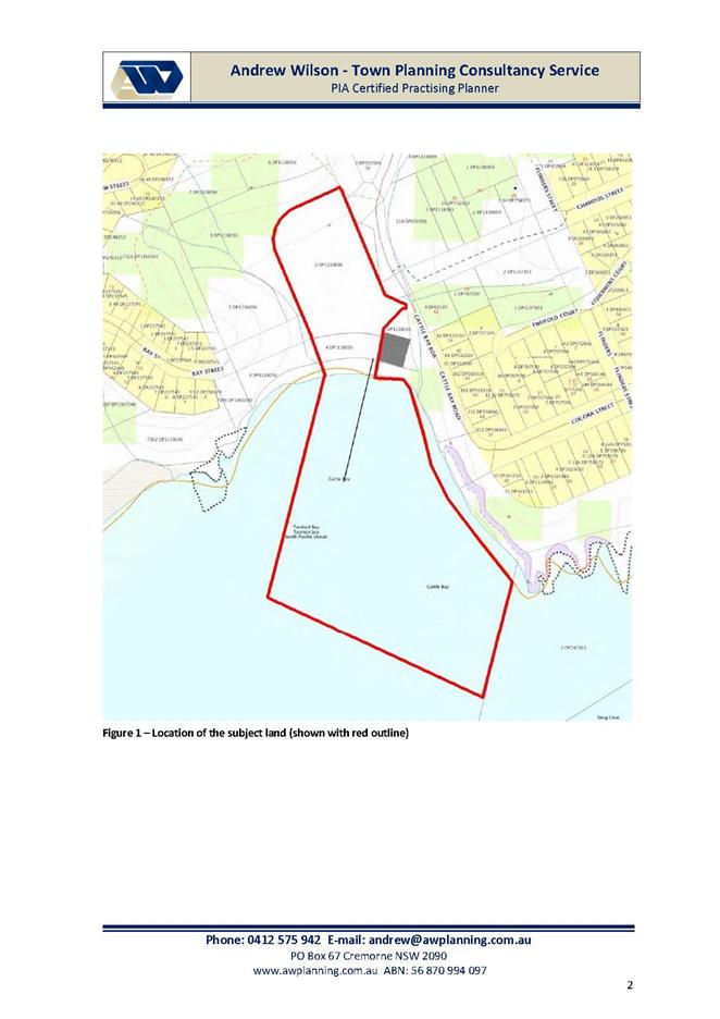
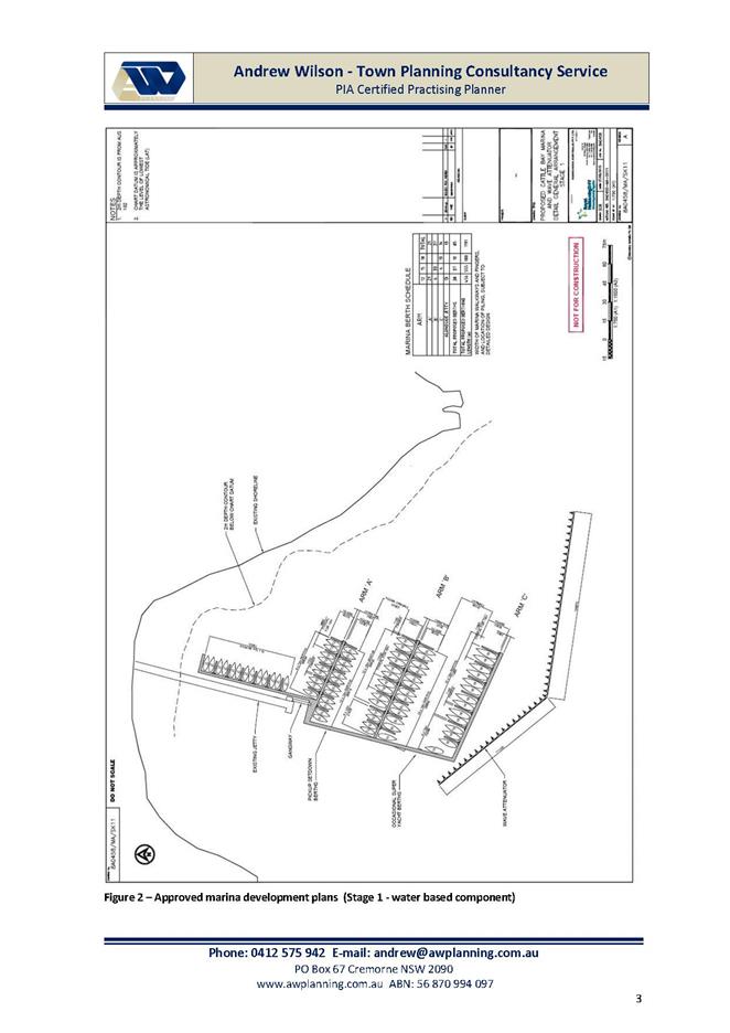
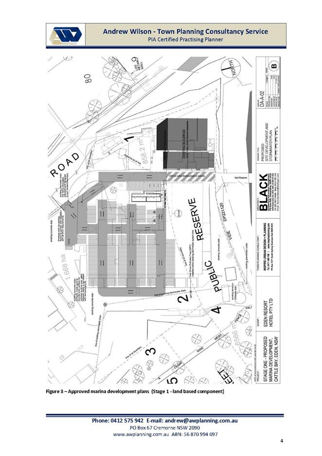
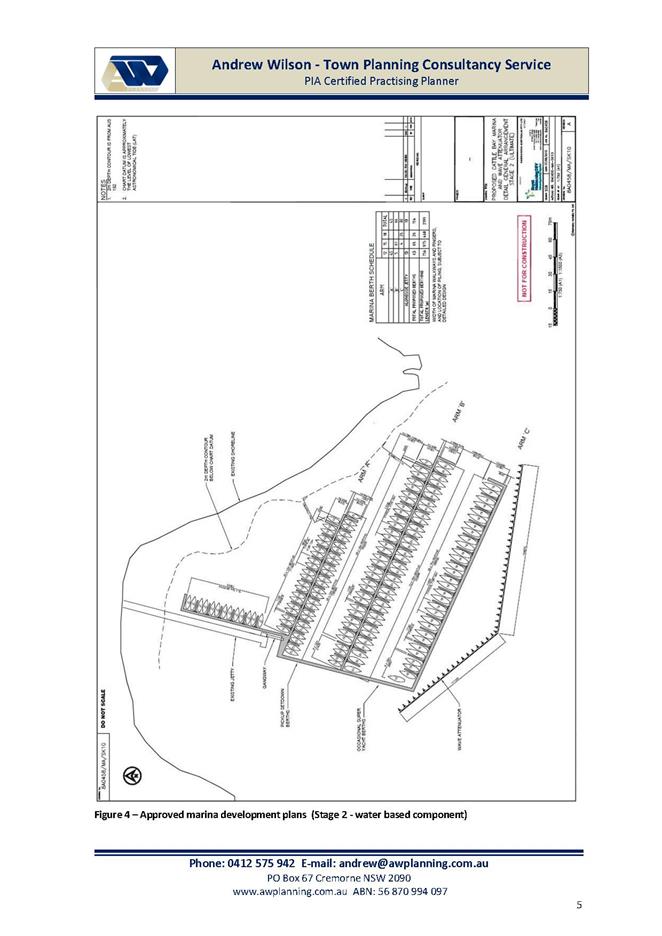
|
Council
|
14 December 2016
|
|
Item 9.6 - Attachment 2
|
Road Condition Assessment Report dated 31 March 2016
|
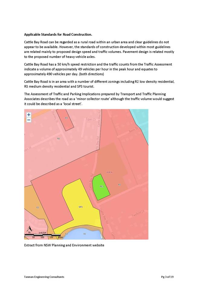
|
Council
|
14 December 2016
|
|
Item 9.6 - Attachment 3
|
Cattle Bay Marina - Addition Load to Sewer Network Report
dated 5 April 2016
|
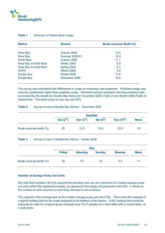
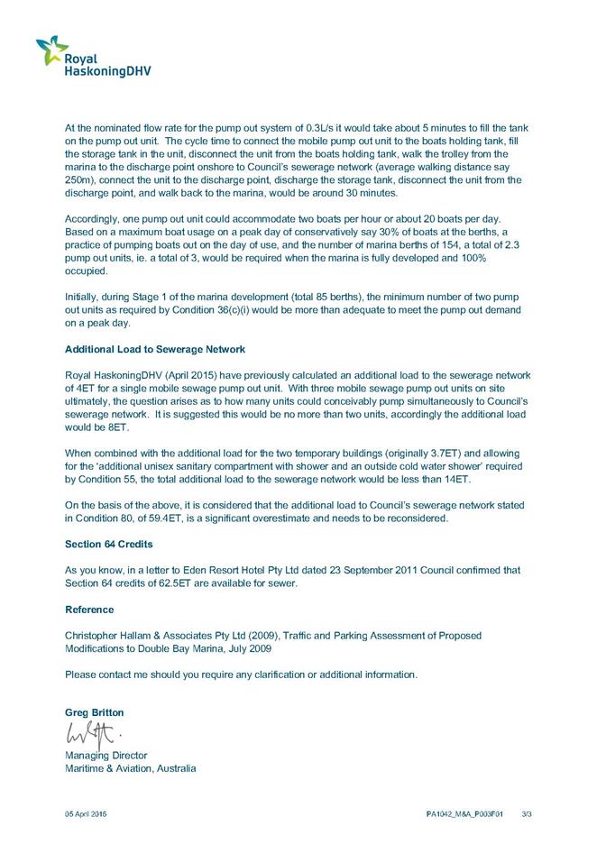
|
Council
|
14 December 2016
|
|
Item 9.6 - Attachment 4
|
Supplementary Report - Section 96 Application to Modify
Development Consent 2014.430 for Cattle Bay Marina dated 25 October 2016
|
|
Council
|
14 December 2016
|
|
Item 9.6 - Attachment 5
|
Supplementary Report - Cattle Bay Marina - Alternative Method
of Sewage Disposal dated 24 October 2016
|
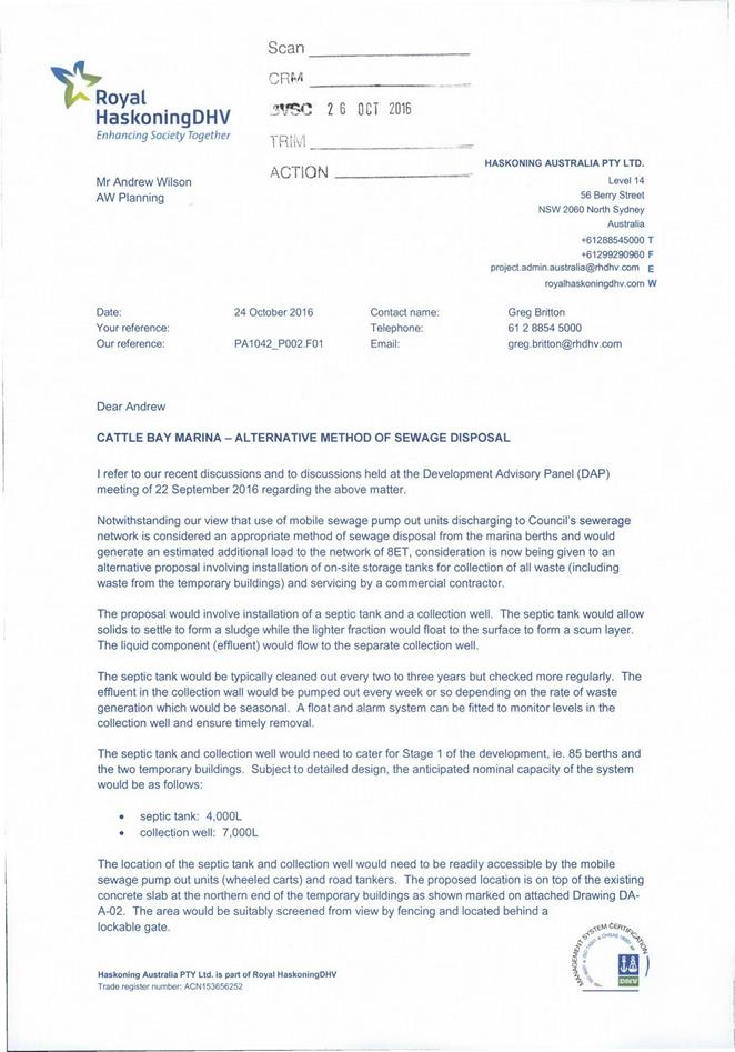
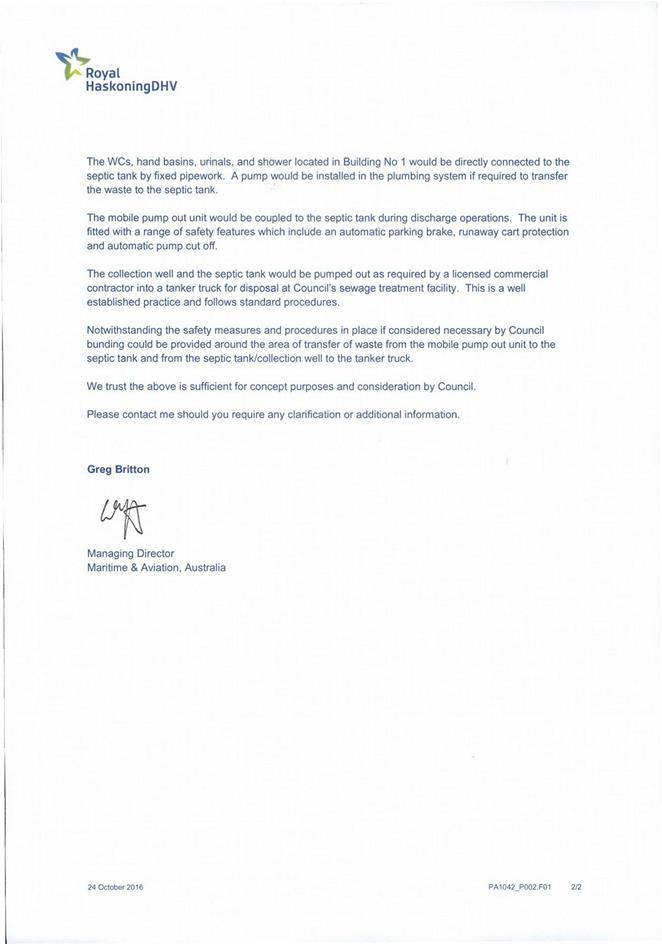
|
Council
|
14 December 2016
|
|
Item 9.6 - Attachment 5
|
Supplementary Report - Cattle Bay Marina - Alternative Method
of Sewage Disposal dated 24 October 2016
|
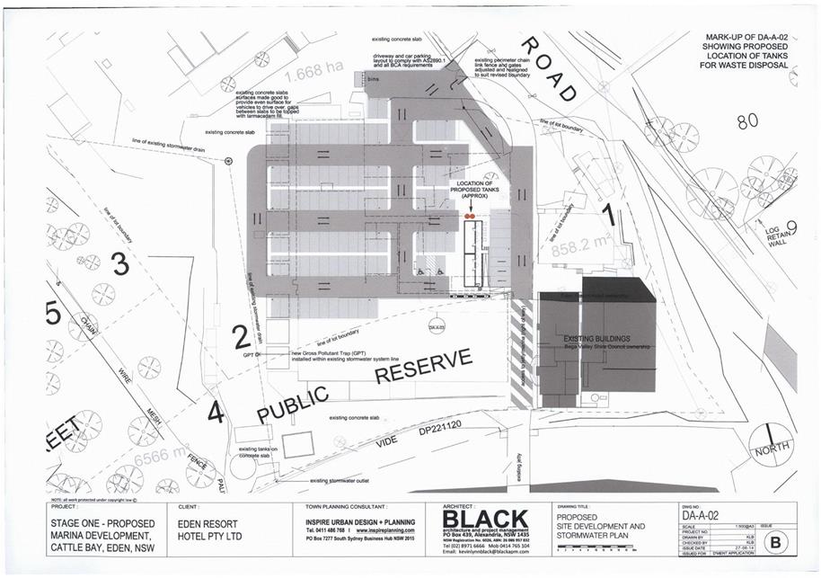
|
Council
|
14 December 2016
|
|
Item 9.6 - Attachment 5
|
Supplementary Report - Cattle Bay Marina - Alternative Method
of Sewage Disposal dated 24 October 2016
|
|
Council
|
14 December 2016
|
|
Item 9.6 - Attachment 6
|
Draft Modification Notice of Determination
|
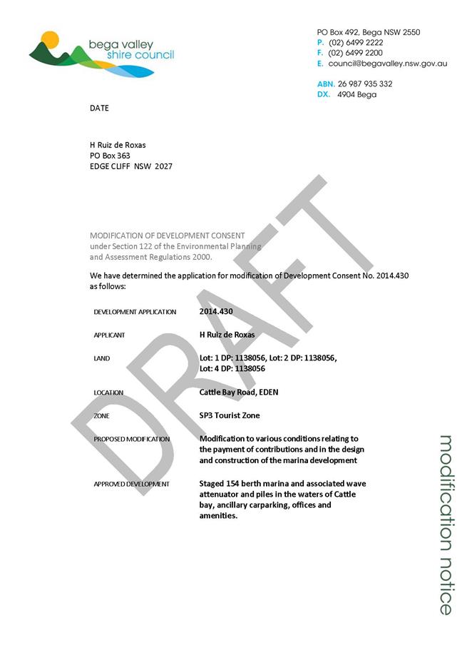
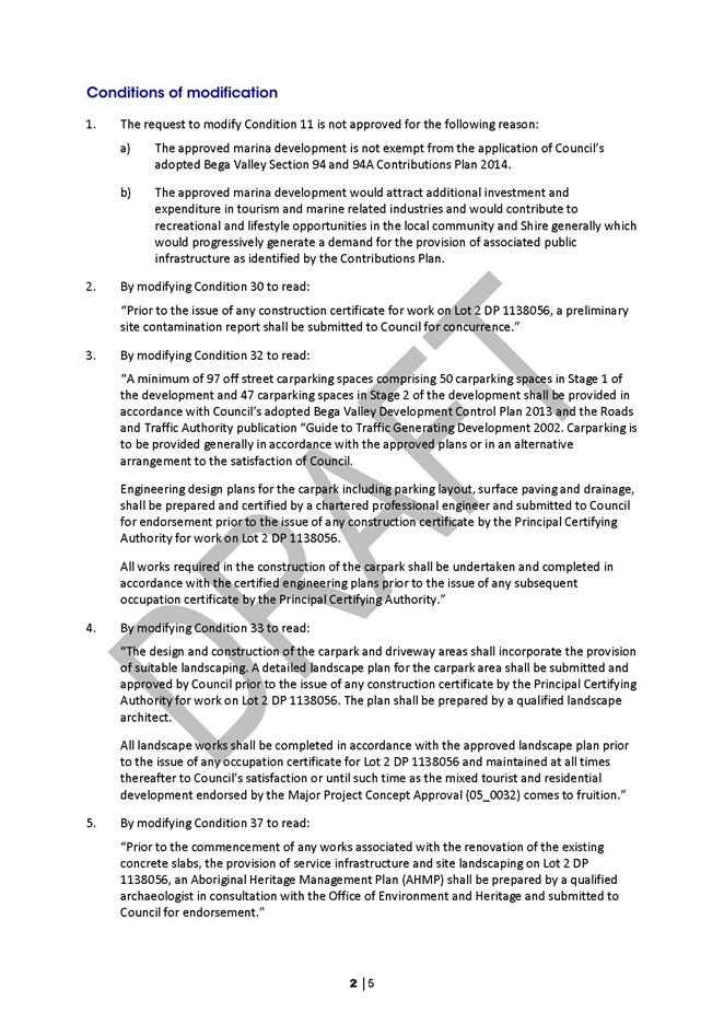
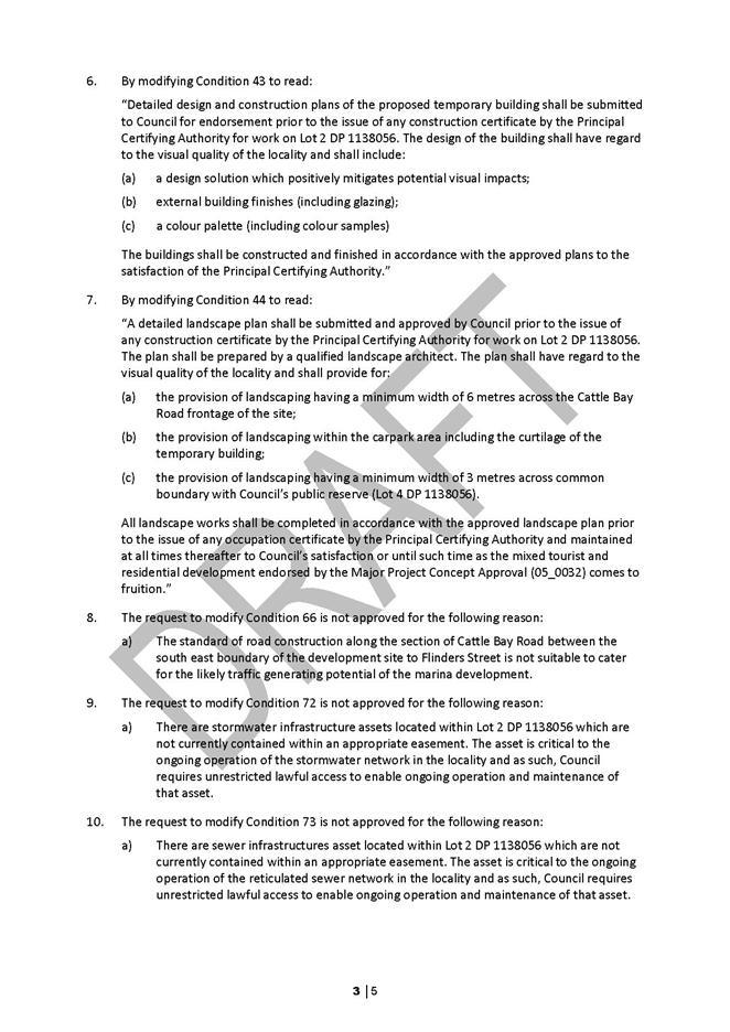
|
Council 14
December 2016
|
Item 9.7
|
9.7. The 25th Annual NSW Coastal Conference
This report reviews the highlights of the
recent 2016 NSW Coastal Conference and announces Council’s success in
being selected to host the 2018 Conference.
Director Planning and Environment
Background
The 25th Annual NSW Coastal Conference was
recently held in Coffs Harbour. The NSW Coastal Conference is the peak
gathering for coastal management, planning, science and engineering industry
professionals and community members. The Conference attracts approximately 250
- 300 delegates including Local Government, State and Commonwealth agencies,
University academics and students, consultants, community group members and
coastal management service providers.
This year’s Conference was set against the backdrop of
the June East Coast Low (ECL) storm event and, as such, the impact and research
of the 2016 ECL event was a major theme at this year’s proceedings. The
research and analysis being undertaken has direct implications for Bega Valley
Shire Council. There are a range of current research and data gathering
partnership opportunities between several universities, the NSW Office of
Environment and Heritage and Council in the ongoing acquisition of Airborne
Laser Surveys, monitoring coastline change and providing definitive information
for key coastal risk areas.
The Minister for Planning and Environment – the Hon.
Rob Stokes, provided a keynote presentation to the Conference to formally
announce the public exhibition of the new draft Coastal State Environmental
Planning Policy. He reviewed the background to the current coastal reforms, but
more importantly detailed his vision for “ground up” strategy
development, based on existing local knowledge and the vast amount of research
and planning that councils and local communities have undertaken in recent
years.
The Minister highlighted the critical economic and social
values of the NSW coast and its environmental sustainability as a key to the
quality of life we enjoy. He spoke of the challenges of dealing with legacy
planning decisions and responding to peoples’ desires to live near the
coast, without compromising these values.
The key message of the Minister was the need to return to
integrated strategic land use planning; that was a feature of coastal
management in the 1970’s and 1980’s. He expressed his observation
at the mistakes made in moving to a more individualistic and market driven
approach in the 1990’s that resulted in poorly located development and
general ribbon development along sections of our coast. Shifting coastal
management back to a truly integrated and strategic setting is the key to
achieving sustainable coastal management in the Minister’s view.
Other major
themes covered at the Conference included the economics of coastal development
and risk, coastal disaster and event emergency management, estuary management,
coastal ecosystem monitoring and restoration, latest climate research and
implications for sea level modelling.
Many of the
coastal engineering research papers presented at the conference have direct
relevance for our Shire with facilities at Eden, Bermagui, Tathra, Merimbula
and proposed developments at Twofold Bay, relying on significant coastal
engineering structures. The need to upgrade current structures to deal with
current and projected extreme wave and storm events and how best to do that,
was a recurring message in many of the engineering and scientific discussions.
Strategic
Whilst
attending the Conference, Council officers took the opportunity to examine the
way in which Coffs Harbour Council is branding their region as the “Coffs
Coast”. They have been successful in the positioning of Coffs Harbour as
a destination for major international, national and state level sporting events
and are receiving the direct economic benefits that flow from these events.
Similar opportunities exist for Bega Valley Shire to develop and promote our
key points of difference around coastal recreation and adventure based sporting
events and the emerging nature health industry.
Financial and Resources
The 2018
NSW Coastal Conference
Bega Valley Shire Council (BVSC) has been selected to host
the 2018 NSW Coastal Conference. BVSC has not previously hosted the Conference.
However with the longest coastline of any Council in NSW and a long standing
and highly regarded coastal management program, BVSC is a natural choice to
host the Conference. Hosting the Conference will enhance Council’s
reputation as a leader in coastal management and planning in NSW.
BVSC is one of the first councils in NSW to undertake its new
Coastal Management Programs (CMPs) under the new Coastal Management Act 2016.
As a leader in NSW Coastal Management, BVSC will be in a position to showcase
its work with regard to both Coastal Planning and on-ground works as a result
of the new CMPs currently being developed for both our open coast and key
estuaries in the Shire.
In addition, November 2018 will have seen some large scale
coastal developments in our Shire, namely the Snug Cove Port development. This
will be a great chance to showcase some of the tourism prospects Bega Valley
has on offer and is an opportunity to promote both our “Coastal
Wilderness” brand as well as Sapphire Coast Tourism initiatives.
The Conference would likely be held in Merimbula in November
2018 and would run for four (4) days. Merimbula provides the required coastal
location, venue requirements, a range of accommodation, airport access and is
central to field trip options that would be a part of the conference program.
We would
look to attract regular attendees at the Conference from across NSW and
additional delegates from Victoria and the ACT. The Conference provides the
opportunity to gain further economic spinoffs by working with Sapphire Coast
Tourism to develop week-long packages to encourage delegates to bring families
and spend the week in our Shire.
It is
proposed to organise the Conference under the auspice of the Director of
Planning and Environment, with Organising Committee members being drawn from
Council’s Planning Services and Environment teams.
The Organising
Committee will receive support from the Conference organisers – East
Coast Conferences for administration and logistic issues such as accommodation,
catering, transport and venue bookings. However officer time will be required
for:
· Reviewing
papers, presentations and content
· Arranging
field trips
· Chairing
panel sessions
These tasks
will be shared between Environmental Services, Planning Services and
representatives from State Agencies such as NSW Office of Environment and
Heritage.
The 2017 NSW
Coastal Conference will be held in November at Ports Stephens, while the 2018
Australian Coast to Coast Conference will be held in April in Hobart. It is
important to attend these conferences as part of promoting our Conference and
provides us with the opportunity to set up a suitable display in the trade
areas of each Conference.
Conclusion
The 2016 NSW Coastal Conference provided officers with
valuable learnings regarding a wide range of contemporary coastal management
issues. Equally important was the opportunity to hold direct discussions with
senior officers from State Government Agencies, including those responsible for
the allocation of various grant funding programs. The exchange of ideas with
fellow local government colleagues from across NSW and QLD was also highly
beneficial, as was the opportunities to investigate research and data gathering
projects with representatives from several universities.
Being selected to host the 2018 NSW Coastal Conference is a
great opportunity for Bega Valley Shire Council to showcase our region and gain
wider economic spin-offs to the local economy.
Attachments
Nil
Recommendation
1. That
Council notes the key outcomes of the NSW Coastal Conference and implications
and opportunities applicable to Bega Valley Shire.
2. That
Council endorses the hosting of the 2018 NSW Coastal Conference.
3. That
Council foreshadows its attendance at the 2017 NSW Coastal Conference in Port
Stephens and the 2018 Australian Coastal Conference in Hobart.
|
|
Council 14 December 2016
|
Item 9.8
|
9.8. Confirmation
of Proposed Minimum Lot Size - Tathra River Estate Stage 3
This report
seeks to confirm the proposed minimum lot size for Tathra River Estate Stage 3
as part of finalisation of outstanding deferred matters from the Bega Valley
Local Environment Plan 2013.
Director Planning and Environment
Background
At its meeting of 29 June 2016 Council considered a report
“8.2 Bega – Tathra Deferred Sites Planning Proposal”, which
recommended appropriate land use zones and minimum lot sizes to five sites in
the Bega – Tathra area, that are deferred from the Bega Valley Local Environmental
Plan 2013.
Following Council’s adoption of the report, the
Planning Proposal was forwarded to the Department of Planning’s Gateway
for approval to proceed to Public Exhibition. During this process the
Department advised Council the resolution with regard Tathra River Estate was
inconsistent with previous discussions and with proposed lot numbers detailed
in the Planning Proposal.
With regard Tathra River Estate Stage 3, Council
resolved;
1. That
in respect of the five deferred sites included in the draft Planning Proposal,
Council resolves the following: ……….
d) Tathra
River Estate, Thompsons Drive, Tathra Lot 2 DP 582074; apply R5, E2 and RE1
zonings and minimum lot size of 1 hectare (R5).
Approximately
40ha of Tathra River Estate – Stage 3 is proposed to be zoned R5 Large
Lot Residential, consistent with Stage 2 which is currently under construction.
With the application of 1ha minimum lot size, 40 lots would notionally be
permissible. The draft Planning Proposal presented to Council and forwarded to
the Department, listed 20 lots as an outcome for this site which was the intent
of the Planning Proposal.
In order to
clarify this matter, prior to Public Exhibition the Department of Planning
requested Council confirm the minimum lot size and consult with the affected
landowner based on previous information they had provided Council and the
Department, with regard a Stage 3 lot layout.
Council
officers have carried out further consultation with the owner of Tathra River
Estate (TRE), who wishes to retain the 1ha minimum lot size for the purposes of
Public Exhibition, which is the minimum lot size for the subdivision currently
under construction and the basis for the various studies and investigations
that have been previously prepared. Officers have also carried out site visits
to Stage 2 of TRE to understand how the 1ha minimum lot size is reflected in on
ground development.
During the
Public Exhibition of the Planning Proposal there is opportunity to review the
extent of the R5 zone which currently encompasses some steep land that may
reduce the number of potential lots that would be available under a 1ha minimum
lot sizing standard. During the Public Exhibition period the owner of TRE will
submit additional master planning for Stage 3, based on scientific, effluent
and engineering studies, which will provide the required detail to make a
proper assessment of the appropriate extent of the R5 zone, the appropriateness
of the 1ha lot size and determine the practical lot yield for the site.
It is
important to progress this matter which will also allow the other four sites
covered by the Bega – Tathra Deferred Matters Planning Proposal to
proceed to Public Exhibition and ultimately to finalisation of their status in
the Bega Valley Local Environmental Plan 2013.
Conclusion
The NSW
Department of Planning and Environment has sought confirmation of
Council’s position with regard the minimum lot size for Tathra River
Estate – Stage 3. Following further investigations by officers it is
recommended Council advise the Department of Planning a 1ha minimum lot size is
appropriate for the purposes of the Public Exhibition of the Bega –
Tathra Deferred Matters Planning Proposal.
Attachments
Nil
|
Recommendation
1. That
Council advise the Department of Planning and Environment that it confirms
its previous Resolution with regard Tathra River Estate as follows:
a) Tathra
River Estate, Thompsons Drive, Tathra Lot 2 DP 582074; apply R5, E2 and
RE1 zonings and minimum lot size of 1 hectare (R5).
|
|
Council 14 December 2016
|
Item 9.9
|
9.9. NSW Coastal Management
Reforms - Draft State Environmental Planning Policy
This report
provides an update on the NSW Coastal Reforms and recommends amendments to the
Draft Coastal Management State Environmental Planning Policy (SEPP) currently
on Public Exhibition.
Director Planning and Environment
Background
The NSW Coastal Reforms represent the most significant
change to coastal management in NSW since the introduction of the Coastal
Protection Act in 1979. The Coastal Reforms package is an integrated legislative
and regulatory framework to provide a modern and consolidated approach to
managing the NSW coastline.
The reforms aim to better equip coastal communities to
respond to the challenges and opportunities that confront them. The legislative
changes and tools implemented and developed as part of the reforms will assist
coastal communities protect the natural values of the coast, support coastal
communities to increase their resilience to existing and emerging hazards and
ensure ongoing public access, use and enjoyment of our beaches, foreshores and
coastal environments.
The NSW Government has announced $83 million dollars in
funding for coastal management activities over the next 5 years.
The Coastal Reforms have three key elements:
|
Coastal
Management
Act
|
|
Coastal
Management
Manual
|
|
Coastal
Management
State
Environmental Planning Policy
|
Coastal
Management Act 2016
The new Coastal Management Act 2016 (CM Act) came
into force in June this year. The CM Act repeals the Coastal Protection Act
(1979) and the Coastal Protection Regulation (2011). The Act aims to
provide a consolidated legislative framework for the management of the NSW
coast and provide for integrated land use planning of the coastal zone.
The CM Act introduces a number of key components to underpin
coastal management in NSW including:
· Replaces
the existing coastal zone definition, with a new coastal zone comprised of four
“coastal management areas”
a. The
coastal wetlands and littoral rainforests area,
b. The
coastal vulnerability area,
c. The
coastal environment area,
d. The
coastal use area.
· The CM Act introduces management objectives for each
of these coastal use areas. These coastal use areas are given effect by the
draft Coastal Management SEPP through mapping and development controls that are
incorporated in the SEPP. The CM Act introduces the requirement for councils to
prepare Coastal Management Programs to set the long-term strategy for the
coordinated management of land within the coastal zone. The Coastal Management
Programs will essentially replace councils’ existing Coastal Zone
Management Plans and can apply to individual locations such as an estuary or
the whole of the coastline, depending on the issue a council wishes to focus
on.
· The CM Act details matters that are to be considered
by a Coastal Management Program, the consultation requirement, certification
and adoption, and mechanisms for review and replacement of a Program.
· The CM Act requires the Minister to publish a coastal
management manual to guide councils in the development of their Coastal
Management Programs. This manual replaces the existing NSW Coastal Management
Manual.
· The CM Act establishes the NSW Coastal Council as an
expert advisory panel to the Minister on coastal management and planning
matters, and to ensure compliance of a council’s preparation and review
of their Coastal Management Programs. The NSW Coastal Council will replace the
statutory NSW Coastal Panel and the Coastal Expert Panel that were previously established
to provide advice on the current reforms.
· Numerous amendments to other pieces of legislation are
outlined in the CM Act, including the Local Government Act (1993) and
the Environmental Planning and Assessment Act (1979). The majority of
the amendments relate to changes in definitions, terminology and procedural
matters.
· The
CM Act also introduces the requirement for a council to integrate its Coastal
Management Programs with its Integrated Planning and Reporting framework.
Coastal
Management Manual
A new Coastal Management Manual has been developed to guide
councils in the development of their Coastal Management Programs. The
Manual is supported by numerous technical resources as part of a Technical
Toolkit developed and maintained by the NSW Office of Environment and Heritage.
The Manual sets out a process for the development of Coastal
Management Programs as depicted in the following diagram:
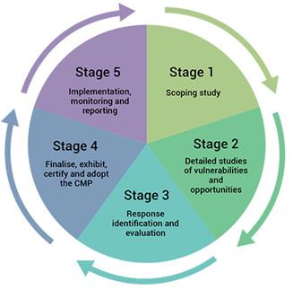
Staff are currently preparing to develop Coastal
Management Programs for: Bermagui River (new program); Wallaga Lake; Merimbula
Lake; Lake Curalo (review of existing Estuary Plans); and another program
focusing on coastal hazards on the open coast.
Draft
Coastal Management State Environmental Planning Policy (SEPP)
The draft Coastal Management SEPP proposes to introduce a
new strategic land use planning framework for coastal management. It will
support implementation of the management objectives set out in the CM Act. The
SEPP will be the single land use planning policy for coastal development and
will bring together and modernise provisions from existing SEPPs.
The SEPP will streamline coastal management and policy
requirements by replacing SEPP 14 (Coastal Wetlands), SEPP 26 (Littoral
Rainforests) and SEPP 71 (Coastal Protection). The SEPP will also incorporate
current coastal related requirements of the Infrastructure SEPP.
The SEPP aims to better equip councils and coastal
communities to plan for and effectively respond to coastal challenges such as
major storms, coastal erosion and climate change impacts, through more
strategic planning for coastal development and emergency management.
The key function of the SEPP is to give effect to the new
Coastal Zone definition and the Coastal Use Areas as established under the CM
Act. As with the former coastal zone the new coastal zone extends 1km landwards
from the mean high water mark from the open coast and tidal limit of estuaries
and coastal lakes.
The SEPP
provides high level development controls for each of the four Coastal Use
Areas.
a. The
coastal wetlands and littoral rainforests area
This area essentially replaces the former
SEPP 14 (Coastal Wetlands) and SEPP 26 (Littoral Rainforests). The mapping used
to inform this area was the result of an in-depth review of the previous SEPP
14 mapping, which had issues regarding scale and accuracy. The development
controls proposed by the SEPP have been largely carried across from the
previous SEPP 14.
b. The
coastal vulnerability area
This area maps land that is subject to a
range of coastal hazards including coastal erosion, coastal inundation and
coastal recession. The coastal vulnerability area seeks to ensure development
that occurs in this area does not compromise public safety, increase risks to
human life or increase current or future risks to public and private assets or
infrastructure. The majority of development controls proposed for this coastal
use area currently apply under the Bega Valley Local Environmental Plan (BVLEP
2013).
It is important the mapping of this area
is consistent with the mapping currently contained in BVLEP 2013 and the Bega
Valley Coastal Processes and Hazards Definition Study (2015), to ensure
consistency between different planning instruments and provide certainty for
Council and for property owners in planning for and dealing with their land.
c. The
coastal environment area
The coastal environment area encompasses
environmental features such as State waters, estuaries, coastal lakes,
headlands and rock platforms. This area has been mapped consistently along the
NSW Coast.
The objective of this area is to protect
the natural features and values through reducing threats that may be posed by
inappropriate development, water quality issues or physical impacts to the
natural feature.
These considerations are currently
undertaken by Council through its assessment of Development Applications for
various forms of development.
d. The
coastal use area
This area represents the remainder of the
coastal zone outside of the first three coastal areas. The SEPP recognises the
economic and social importance of this area and development controls focus on
issues related to development form and scale, provision of adequate public
space and access, and ensuring the economic, social and environmental values of
the coastal zone are not compromised. The SEPP specifically notes the need to
accommodate both urban and natural stretches of the coast in this area.
Submission to the Draft Coastal Management SEPP
The draft Coastal Management SEPP is on public exhibition
until 23 December 2016. Council officers attended a briefing session on 25
November 2016 in Moruya to assist in the preparation of advice to Council
regarding issues requiring inclusion in a submission to the draft SEPP.
Due to the restricted timeframe provided to make a
submission to the draft SEPP and Council meeting schedule, officers seek
Council endorsement of key issues to be included in Council’s submission.
Officers suggest the following points form the basis of our
submission:
· That Council supports the rationalisation of existing
SEPPs into the Coastal Management SEPP as a key step forward in streamlining
coastal management and planning and modernising coastal management in NSW.
· That the mapping of the Coastal Vulnerability Area in
the draft SEPP reflect Council’s existing standards within the BVLEP,
Bega Valley Coastal Processes and Hazards Definition Study 2015 and draft
Merimbula and Back Lakes Flood Study (2016). This is to ensure consistency with
Council’s current planning policies and studies, certainty for our
community and for individual property owners.
· That the Coastal Zone be mapped along the closest
existing and/or practical cadastral boundary to the exhibited 1km extent. This
is to provide a consistent approach across existing settlements and individual
properties and provide clarity during the development assessment process.
· That Council seeks the inclusion of the Bega and
Towamba Rivers into “Schedule 2 Coastal Lakes” of the SEPP, to
ensure consistency in the application of the SEPP across our coastal zone.
· That Council requests the NSW Department of Planning
and Environment to examine alternative legislative pathways to allow the future
amendments of the SEPP mapping, rather than the suggested Planning Proposal
pathway, which has proved cumbersome and inefficient.
· That Council requests the funding allocated by the NSW
Government be available for the development and implementation of existing
Coastal Management Programs and any required changes to the BVLEP and Bega
Valley Development Control Plan 2013.
Attachments
Nil
|
Recommendation
1. That
Council notes the current status of the NSW Coastal Reforms.
2. That
officers prepare a submission to the draft Coastal Management State
Environmental Planning Policy based on the issues highlighted in this report
and forward it to the NSW Department of Planning and Environment within the
Public Exhibition period.
|
Staff Reports – Community, Culture and Leisure (Liveability)
14 December 2016
In accordance with
Council’s Code of Meeting Practice (2011), this section of the agenda
will be chaired by Cr Griff.
10.1 National
Youth Week 2017 Grants.................................................................... 138
10.2 Seniors
Festival 2017 Grants ........................................................................... 141
10.3 Community
Project Proposals........................................................................... 144
10.4 Coastal
Accessibility Project and Master Plans ............................................... 155
|
Council 14 December 2016
|
Item 10.1
|
10.1. National Youth Week 2017 Grants
Applications have been
received for Council’s 2017 National Youth Week Small Grants Program and
are presented for Council’s consideration.
Director Community, Relations and Leisure
Background
National Youth Week (NYW) is Australia’s largest
celebration of young people aged from 12 to 25 years of age. The dates for
National Youth Week 2016 are from 30 March to 9 April 2017. NYW will showcase
and celebrate the valuable contribution young people make in our communities.
All activities are planned and delivered in close collaboration with young
people (for young people by young people).
A major way in which Council supports NYW in the Bega Valley
Shire is through the provision of small grants. These grants encourage community
members to work with young people to run activities that are accessible to a
broad range of young people across the Bega Valley Shire. Successful projects
should demonstrate the involvement of young people in the planning and
implementation of activities.
Bega Valley Shire Council (BVSC) has provided these small
grants to community/not for profit organisations for nine years. The total
budget of this initiative in 2017 is $5,000.
On 26 October 2016 the BVSC NYW 2017 Small Grants Program
was opened and eligible organisations were invited to apply for grants up to
$1,000. These grants were promoted via email networks, media releases, word of
mouth and through social media.
All applications for the 2017 grants were submitted through
an online application system.
The 2017 grant application period closed on 21 November 2016
with twelve applications being received. The grant funding requests total
$11,175 which is $6,175 over the allocated budget.
Applications were received from a broad cross section of the
community, and whilst all can’t be funded, the number suggests a positive
move from lower application numbers in previous years.
A table summarising the
applications against the assessment criteria is attached for Council's
consideration.
Issues
Legal
Under S356 of the Local Government Act 1993 Council has the
ability to provide grants for organisations to undertake activities Council
would otherwise deliver.
Strategic
The BVSC NYW Program addresses two strategic outcomes in the
Liveability section of the Bega Valley Community Strategic Plan 2030. Outcome
2.6 “Community actively participates in events, festivals and creative
community activities” and, Outcome 4.1 “Young people are involved
in all aspects of local life - including civic leadership, business, education
and volunteering.”
Operational
Plan
Administration of the NYW small grants Program is part of
the Community Development team’s annual operations.
Social
/ Cultural
NYW is an opportunity to recognise the meaningful
contributions of young people to local communities. It is a time to encourage
community dialogue in relation to issues impacting on young people and
pro-active responses. In addition it fosters community connection and decreases
isolation for rural young people. Young people’s involvement in the
planning and delivery of events supports both skill development and confidence
building in individuals.
Consultation
A central component of the eligibility criteria for these
grants is engagement with young people. Council’s Place Based
Officers engaged a wide range of organisations and young people in the
promotion of these grants.
Financial
and Resources
The events were to target young people between the ages of
12 and 24. Applications were assessed against the following criteria:
· Demonstrate
the engagement of young people in the planning and delivery of activities;
· Demonstrate
access to activities from a broad range of young people;
· Increase
the community’s awareness of young people and the issues that are
important to them;
· Identify
opportunities and ideas with young people;
· Develop
strategies to nurture these opportunities and ideas;
· Promote
young people’s contributions to our community; and
· Be
delivered at no charge to participants.
All applications received represent a broad cross section of
activities and events that would ensure a vibrant Youth Week calendar, and in
their own right were positive events for the young people in our Shire.
All applicants met the criteria; however given significantly
more funds were requested than are available, further consideration was given
to the following:
· A geographic
spread of events during NYW – in the past activities based in the North
of the Shire have been difficult to attract (this year we have two) and a
number of events were targeted in and around the Bega area;
· Had the applicants
received funding in 2016;
· Were the
applications targeted at the 12 to 24 year old age group?
Budget is identified to cover the grants program as outlined
below.
|
Funding source
|
|
Amount
|
|
BVSC NYW Small Grants
Program
|
$
|
5,000
|
Conclusion
The BVSC NYW Small Grants Program is an effective way for
Council to assist the community to deliver events that will ensure a vibrant
Youth Week calendar. The recommended events provide a broad cross section of
activities for young people in the Shire.
Attachments
1. Youth
Week 2017 Small Grants Assessment Table (Councillor Only) (Confidential)
|
Recommendation
1. That
Council note the report.
2. That
Council accept the recommendations as outlined in the attachment.
3. That
Council make the following allocations through the National Youth Week 2017
Small Grants program for a total of $<>:
-insert
4. That
all applicants are advised of the outcome.
5. That
the Councillor only attachment be made public.
|
|
Council 14 December 2016
|
Item 10.2
|
10.2. Seniors
Festival 2017 Grants
Applications
have been received for Council’s 2017 NSW Seniors Festival Small Grants
Program, formally known as Seniors Week and are presented for Council’s
consideration.
Director Community, Relations and Leisure
NSW Seniors Festival is the largest festival for seniors in
the Southern Hemisphere. The NSW Seniors Festival will run from Friday 3 to
Sunday 12 March 2017. The NSW Seniors Festival was previously known as NSW
Seniors week; however in 2016 the NSW Government rebranded this event to
establish a vibrant new look.
A major way in which Bega Valley Shire Council (BVSC)
supports the Seniors Festival in the Bega Valley Shire is through the provision
of small grants. These grants encourage community members to develop and run
activities accessible to a broad range of older people across the Bega Valley
Shire.
Council has provided these small grants to community/not for
profit organisations for nine years. In 2016, Council resolved to increase
these grants from $5,000 to $10,000 for 2017.
On 26 October 2016 the BVSC NSW Seniors Festival Small
Grants Program was opened and eligible organisations were invited to apply for
a grant for up to $1,000. These grants were promoted via email networks, media
releases, word of mouth and through social media.
Applications for these grants closed on 21 November 2016.
This year Council has received twelve applications which is the largest number
of applications for funding since the inception of the grant. Applications were
received from groups and organisations across the Shire and the proposed
activities target seniors with a range of abilities and interests.
The total funding requested, $10,621 slightly exceeds the
funding available.
Applications were received from organisations representing a
broad cross section of the community, and were assessed against the
criteria.
A table summarising the
applications against the assessment criteria is attached for consideration.
Issues
Legal
Under S356 of the Local Government Act (1993) Council
has the ability to provide grants for organisations to undertake activities
Council would otherwise deliver.
Strategic
Seniors Festival activities support two strategic outcomes
in the Liveability section of Council's Community Strategic Plan 2030. Outcomes
L2.6 ‘Community actively participates in events, Festivals and
creative community activities’ and L1.5 ‘Healthy lifestyles
are promoted through health promotion, support networks and facilities’.
Operational
Plan
Administration of the Seniors Festival Small Grants Program
is part of the Community Development team’s annual operations.
Social
/ Cultural
Council’s Social Issues Papers highlight a range of
social issues affecting older people in the community. Social isolation and
men's health are among those addressed by the proposed Seniors Festival
activities. Seniors Festival programs also build on the community strengths,
building and supporting volunteering and participation in community life by
all. In addition, a number of proposed activities have a strong cultural
component.
Consultation
Council’s Place Based Officers engaged a wide range of
organisations and older people in the promotion of these grants.
Financial
and Resources
Not-for-Profit community organisations were invited to apply
for funding to assist in the delivery of Seniors Festival events, in and around
seniors week 2017. Applications were assessed against the following criteria:
· Demonstrate
the engagement of older people in the planning and delivery of activities;
· Demonstrate
access to activities from a broad range of older people;
· Increase
the community’s awareness of older people and the issues that are
important to them;
· Identify
opportunities and ideas with older people;
· Develop
strategies to nurture these opportunities and ideas;
· Promote
older people’s contributions to our community; and
· Be
delivered at no charge to participants.
In total, Council received twelve applications for the
Seniors Festival Small Grants Program for 2017. The total amount sought was
$10,621 from a funding pool of $10,000. All applications received represent a
broad cross section of activities and events that would ensure a vibrant
Seniors Festival calendar, and in their own right were positive events for
older people in our shire.
Budget is identified to cover the grants program as
outlined below.
|
Funding source
|
|
Amount
|
|
Community Development
Seniors Grants program
|
$
|
10,000
|
Conclusion
The BVSC Seniors Festival Small Grants Program is an
effective way for Council to assist the community to deliver events that will
ensure a vibrant Seniors Week calendar of events. The recommended events
provide a broad cross section of activities for older people in our
shire.
Attachments
1. Seniors
Festival 2017 Grants Assessment Summary (Councillor Only) (Confidential)
|
Recommendation
1. That
Council note the report and accept the recommendations from the confidential
memorandum.
2. That
Council and make the following allocations through the Seniors Festival 2017
Small Grants Program, for a total of $<->:
-
insert
3. That
all applicants are advised of the outcome.
4. That
the Councillor only attachment be declassified and made available to the
public.
|
|
Council 14 December 2016
|
Item 10.3
|
10.3. Community
Project Proposals
This report provides a
summary of community project proposals received between 1 July 2016 and 18
November 2016 for Council's information and consideration.
Director Community, Relations and Leisure
Background
The community has an important role in helping Bega Valley
Shire Council (BVSC) identify and deliver new and/or improvements to community
facilities. More often than not Council will become responsible for all works
on Council managed land including compliance, maintenance, upkeep and safety.
With this in mind, regardless of the project size, all works proposed for
Council managed land need to be considered in the context of all project
elements including: funding; personnel; procurement; risk management; workplace
health and safety; environmental considerations; approvals; compliance; and
ongoing maintenance. It is also important to consider how the proposed works
can link and add value to other planned Council projects, particularly in terms
of the maintenance and replacement of existing assets.
Council’s Community Project Proposal Procedure applies
to the full spectrum of projects from small scale through to larger more
complex projects. One of the aims of the procedure is to make sure all relevant
project issues are considered and addressed.
The procedure involves reporting proposals to Council,
particularly where projects are complex and/or will require resourcing from
Council. Those proposals that are straight forward and are not requesting
funding from Council are reviewed and approved by officers enabling groups to
get on with their proposed works.
The level of resourcing and contribution sought from Council
is an important aspect for consideration. Council resources are limited and
favouring one project over another or promotion of a project is likely to
affect or defer the delivery of other planned and programed works. That is not
to say that contribution is not possible, particularly where projects link to
strategic plans or programed works clearly identify inputs from project
partners, and clearly justify the Council contribution by demonstrating good
value for requested funds.
It is important to be able to give proposals the
consideration they need and deserve, and to work out where they fit with other
planned and programed works. The level of information included in the proposal
needs to be sufficient to enable the merits and issues of proposals to be
understood by officers and Councillors. Thorough proposals will clearly show
the merit of the project, outline what is being requested and how potential
issues have been addressed. The initial assessment by Council officers seeks to
minimise wasted effort (or expense) on proposals that may not obtain approval
due to funding, planning or other reasons.
The Community Project Proposal Procedure and the Proposal
Form is available on Council's website.
This report contains Proposals received between 1 July 2016 and 18 November 2016 that include sufficient
information for consideration by Councillors. Future proposals will
continue to be presented on a quarterly basis to Council for consideration and
resolution.
Attached is a summary of the Project Proposals received
including comments and recommendations. Hard copies
of each of the full Proposals received have been distributed to Councillors for
their reference and review.
In-principle support does not
commit Council to funding the project, only support, which enables applicants
to progress with project development. There were also Proposals received from Bermagui
Area Chamber of Commerce and Tourism; Bemboka Sports Social and Recreation Club
Inc.; and Eden Local Aboriginal Land Council; however Council officers continue
to work with these groups so the Proposals encompass sufficient detail for
considered review and future reporting to Council where required.
Issues
Legal
There can be legislative
requirements that come into effect if the implications of works are not
understood and accounted for in the project development stage. These include:
environment and heritage; access and building code compliance; planning and
development approvals; and in some instances land ownership.
Strategic
Council has a number of strategic and operational plans that
outline the current and future priorities of infrastructure, civil assets and
facilities capital works. For example Asset Management Plans (AMP) identifies
current assets, their condition and when they are programed to be replaced. The
Long Term Financial Strategy (LTFP) outlines how Council will pay for the replacement
or upgrade of those assets.
Strategic Plans identify upgrades or new works based on
current and expected future needs.
Policy
Council’s Procedure 4.01.3 Community Project Proposals
has been developed to manage project proposals by committees and community
groups for the development and delivery of community infrastructure, civil
assets and facilities.
Operational
Plan
Relevant key directions identified in the Council’s
Operational Plan are:
S4 Proactive support and planning: There is proactive
planning with the community for the protection of our built and natural
environment.
A2 Facilities and services: Our infrastructure,
facilities and services are strategically planned, located, designed and
maintained to meet our local and visiting community needs.
Asset
Council has an adopted Capital
Works Program included within the asset management structure. Asset management
capital works programs are based on asset renewal (e.g. replacing existing
assets to meet a similar service or provision level) as determined in
Council’s AMP. The large majority of projects proposed by the community
relate to new works or significant upgrades of existing assets and as such are
not included in capital works programs. Where projects are linked to works
identified in AMP’s this is clearly noted.
Social
/ Cultural
The community has an important
role in helping Council identify and deliver new and/or improvement projects.
Council recognises and values the important role and contribution of
committees, community groups and volunteers in the management, operation and
maintenance of Council infrastructure, civil assets and facilities.
Consultation
In developing the Community
Project Proposal Procedure, consultation was undertaken with Council's Access
Committee, the S355 Sportsground Committee and also through a workshop
involving representatives of service organisations from across the Shire.
The Project Proposal form
includes a section on stakeholder engagement in which the applicant can
identify the consultation they have undertaken and feedback they have received
in the development of their proposal.
Financial
and Resources
Committees, community groups and volunteers often seek
funding and grant opportunities to support their project proposal. It is
important that people talk with officers prior to applying for funding to do
work on Council assets. This ensures the project scope is clear and complete,
the resources identified are sufficient to complete the works and there is a
level of coordination to prevent already approved projects competing with new
projects for the same external Grants.
The table below shows a summary of Community Project
Proposal applications received between 1 July 2016 and 18 November 2016 that
include sufficient information for consideration by Councillors.
Some applications that relate directly to required asset
renewals or are not requesting funding from Council, have been able to be
approved by officers to enable works to proceed.
|
|
Number
|
Total Estimated
Commercial Cost
|
Applicant Contribution
|
Requested Council
Contribution
|
|
Total Project Proposals
Received
|
11
|
$132,891
|
$73,326
|
$59,565
|
|
Project Proposals
Approved
|
8
|
$80,614
|
$73,326
|
$7,288
|
|
Project Proposals Seeking
Council Resourcing
|
3
|
$52,277
|
$0
|
$52,277
|
Conclusion
The Community Project Proposal process seeks to provide a
consistent framework for Council to receive and consider the wide range of
suggestions for projects put forward by the community. Often these projects
relate to new works or major upgrades and as such have not been identified in
the development of capital works programs included in AMPs.
The challenge is to give proposals the consideration they
need and deserve and to work out where they fit with other planned and
programed works. The level of resourcing and contribution sought from Council
is an important consideration.
Attachments
1. Community
Project Proposals Summary - December 2016
|
Recommendation
1. That Council note the
report.
2. That Council note the
Community Project Proposals reviewed and approved by officers:
a. The Bermagui Cricket
Club - Stage 1 of the Dickinson Oval Cricket Nets Upgrade (Berm1);
b. Pambula Cricket Club
for the Replacement Cricket Pitch – Pambula Sporting Complex
(Mer1);
c. Merimbula &
Pambula Rotary for the Access Path to Fishpen Toilets (Mer2);
d. Merimbula Sailboard
Club for Enhancing Food Preparation Area (Mer3);
e. Merimbula Sailboard
Club for Protecting BBQ From the Elements (Mer4);
f. Merimbula &
Pambula Rotary for Footpaths Connecting Ocean Drive to Calendo Court and
Burton Avenue (Mer5); and
g. Eden Swimming Club for
Tree Wind Break – Eden Pool (Eden2).
2. That Council adopt the
following recommendations for the Community Project Proposals:
a. That
Council provide support to the Bermagui Cricket
Club for Stages 2 and 3 of the Dickinson Oval Cricket Nets Upgrade (Berm1)
and write to the applicant formalising support to enable the applicant to
investigate other funding opportunities.
b. That Council
acknowledge the merit of the On Track proposal for External Electricity
Outlets (Bega1); however note there is no current funding allocation.
c. That
Council support the BRAWL proposal for the Spenco Lagoon Community Path (Bega2)
and subject to required project
information being provided, officers work with the group to further develop
and explore the proposal and enable the applicant to investigate other
funding opportunities.
d. That
Council note the merit of the Tathra Headland and Wharf Access Group's
proposal for the Tathra Headland Pathway Design (Bega4) and consider funding as a potential 2017-18
Budget item.
e. That Council
note the actions taken and feedback provided to Wonboyn Ratepayers
Association Wonboyn Road Beautification (Eden1) and that no funding be
provided as the works are on private land and works are not linked to BVSC
planned or programed works.
|
|
Council
|
14 December 2016
|
|
Item 10.3 - Attachment 1
|
Community Project Proposals Summary - December 2016
|
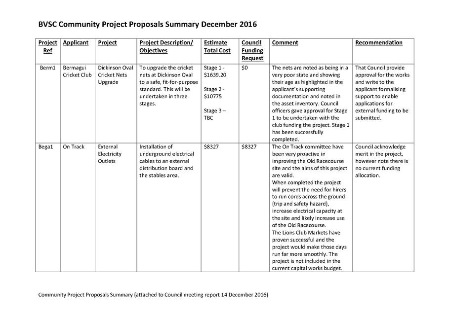
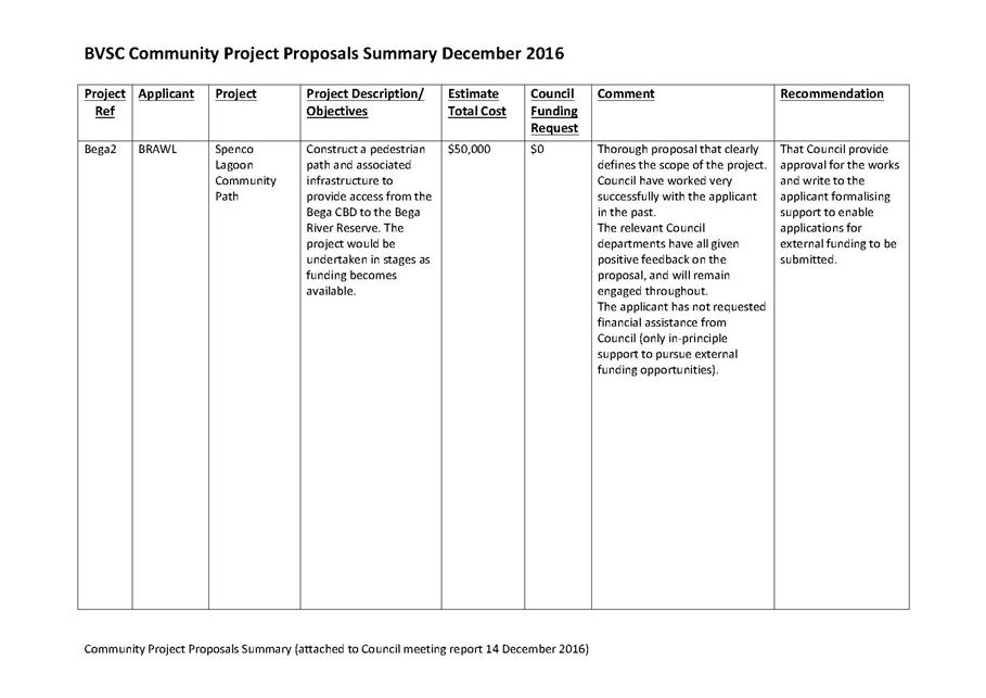
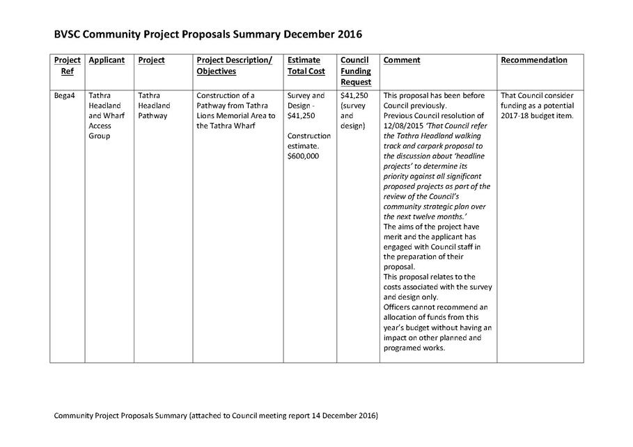
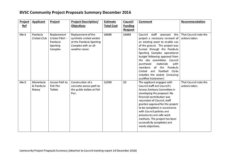
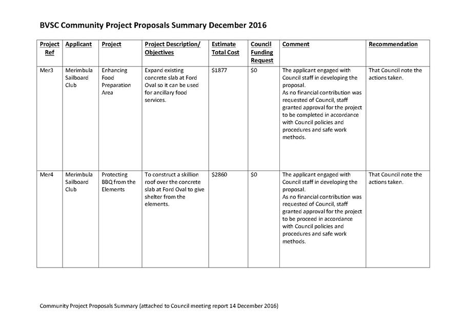
|
Council 14
December 2016
|
Item 10.4
|
10.4. Coastal
Accessibility Project and Master Plans
Master Plans have been
developed for Bruce Steer Pool in
Bermagui, Short Point in Merimbula and Pambula Beach Reserve at Pambula Beach to guide the future development of these key coastal
sites. The final Coastal
Accessibility Master Plans are presented
to Council for adoption.
Director Community, Relations and Leisure
Background
Bega Valley Shire Council (BVSC) engaged Spiire Australia
Pty Ltd to develop Coastal Accessibility Master Plans (Master Plan/s) for three
key sites within the municipality. The sites are: Bruce Steer Pool in Bermagui;
Short Point in Merimbula; and Pambula Beach Reserve at Pambula Beach.
A Master Plan is a strategic document that outlines the
intended developments for a site. In the case of this project the plans
investigate and provide guidance on:
· Improving accessibility to all features and facilities
of the sites
· Promoting a more active and inclusive local community
· Providing facilities which will benefit those with
mobility limitation as well as those living with injury and/or disability
· Protecting and enhancing coastal vegetation, reducing
weed infestation and improving
Erosion and environmental values through revegetation
· Improving visual amenity and enhancing recreational
opportunities
· Improving community engagement and educational
opportunities inherent to the site
· Recognition of sites of Aboriginal and European
heritage
· Enhancing visitor
and tourist experience.
The project has explored issues and opportunities, site
specific challenges and community comments and ideas for site improvements. The
information gathered has been distilled in order to prepare the Master Plans
for the three sites.
The Master Plans describe the design intent, recommendations
and estimated costs which provide a framework for the future implementation of
prioritised and budgeted works.
Once adopted, the Master Plans will be a
useful resource in the planning of both capital renewal and new works on the
sites. Referral to an adopted Master Plan document is a critical aspect of
completing funding applications, particularly for major projects. Once adopted,
the Master Plans can be viewed on Council’s website www.begavalley.nsw.gov.au or at Council’s library sites located at: Eden; Tura; Bega; or
Bermagui.
Issues
Legal
The three sites are Council managed Crown Land.
Strategic
The Master Plans identify the current and future needs of
the community and guide the creation of recreational facilities to cater for
those needs; with a particular focus on improving accessibility at the sites.
Importantly the planning process also identifies opportunities that will add
value to the sites and allow for increased recreation opportunities and
participation ensuring that future improvements provide good value to the
broader community and are fully utilised.
Policy
Numerous Policies and Procedures will be relevant in the
implementation of these Master Plans (including but not limited to): Use of
Council Land; Environment Management; Soil and Water Management; Weed
Management; Pesticide Use; and Asset Management.
Operational
Plan
The delivery of the Master Plans links to the following
ambitions and outcomes identified in the Bega Valley Community Strategic Plan
2030:
Community Ambition A2: Facilities and services: Our
facilities and services are strategically planned, designed and maintained to
meet the community needs.
Outcome Area A2.3: Safe and well maintained sporting
fields, recreation areas and built facilities meet the cultural, recreational,
tourism and community service needs of all ages and abilities in our community.
Environmental
/ Sustainability
Major projects and new works identified may require a Review
of Environmental Factors to be completed in the development of those specific
projects.
Social
/ Cultural
The project recognises the unique coastal environment of the
Bega Valley Shire is one of its greatest attractions for residents and
visitors. The rugged coastline is dynamic, varied and generally pristine. The
Shire’s coastal environments provide a range of recreational opportunities
such as: swimming; surfing; fishing; strolling along the beach; or resting to
absorb the magnificent views.
While the coastline is a key identifying feature of the
Shire, it also restricts people with mobility limitations and in many cases
prevents them from enjoying the natural assets and recreation activities along
the coast. This project is focused on improving accessibility to three key
coastal locations to break down some of the barriers presented to those with
limited mobility and their carers.
Consultation
and Master Plan Development
Broad and proactive consultation was a key focus throughout
the projects and included:
· A community feedback form was developed to obtain the
thoughts and ideas of the community. The feedback form was available on the
Council’s website and hard copies were available from the Council Offices
and Libraries
· Issues, opportunities and constraints sketch plans
were prepared for use in the Stage 2 consultation phase with stakeholders and
the wider community
· Extensive site investigations and meetings with BVSC
officers and key stakeholders including the: BVSC Access Advisory Committee;
Engineering team; Leisure and Recreation team; Environmental Management
Officers; and Aboriginal Liaison Officer.
· Meetings were held at each site with key local
stakeholders identified by BVSC officers as having a significant amount to add
to the project.
· Listening Posts were held at each project location to
provide the community with the opportunity to talk to the project team and have
their say about what they liked and what they would like to see improved. The
Listening Posts and attendance numbers were: Bruce Steer Pool 20 – 30;
Short Point 15 – 20; Pambula Beach 10 – 15.
· Draft Master
Plans were prepared, including findings from the early stages of the project.
The draft report was the subject of a Councillor workshop and a further round
of community consultation through a Public Exhibition period.
· An assessment of submissions received during the
Public Exhibition period and liaison with officers to confirm agreed
amendments.
· The final Master Plans have been prepared and are
available to the public.
Financial
and Resources
The Coastal Accessibility
Master Planning Project is being funded from
three sources:
· Leisure and
Recreation budget. (Bruce Steer Pool)
· Office of
Environment and Heritage (OEH). (50% Short Point)
· Surf Life Saving
NSW community inclusion grant. (Pambula Beach)
The Master Plans identify and prioritise projects which will require
funding and resourcing in the future; however once adopted, the documents will be a useful resource
in the planning of both capital renewal and new works on the sites. Referral to
an adopted Master Plan document is a useful aspect of completing funding
applications, particularly for major projects. The State Government’s
Public Reserve Management Fund (PRMF) is one such potential source of funding
for projects on Crown Lands.
Conclusion
The final Master Plans have been completed and amendments
made considering comments and feedback received during the Exhibition period. A
summary of the feedback and the amendments and/or comments in response to the
feedback has been included in the documents. The final documents are being
presented for adoption.
Once adopted, the Master Plans will provide a framework for
the future development and enhancement of the sites. Importantly the planning
process has looked to preserve and add value to the unique attributes of the
areas and ensure these sites are, carefully developed, well managed and fully
utilised into the future.
Attachments
Nil
|
Recommendation
1. That
Council note the report.
2. That
Council adopt the Coastal Accessibility Master Plans for Bruce Steer Pool in Bermagui, Short Point in Merimbula and Pambula
Beach Reserve at Pambula Beach
3. That
stakeholders be notified and thanked for their interest and input into the
planning project.
|
Staff Reports – Economic Develoment and Business Growth (Enterprising)
14 December 2016
In accordance with Council’s Code of Meeting
Practice (2011), this section of the agenda will be chaired by Cr Nadin.
11.1 Classification
of land recently acquired by Council.......................................... 160
11.2 Lease
to Bermagui Pre School.......................................................................... 162
11.3 Bega
Valley Economic Summit Report............................................................. 166
11.4 Request
to lease a section of unformed road reserve and permanent road closure at
Bermagui........................................................................................................................... 181
11.5 Community
Consultation - Air Service deregulation........................................ 206
11.6 EOI
104/16 142-144 Imlay St. Eden Purchase, restoration and other conditions of
sale 208
|
Council 14 December 2016
|
Item 11.1
|
11.1. Classification of land recently acquired by Council
Council has recently
completed the acquisition of land at 243 – 245 Newtown Road in
Bega. Final approval is being sought to classify the land recently
acquired as Operational Land under the Local Government Act.
Director Strategy and Business Services
Background
Council officers presented a confidential report to Council
on 29 June 2016 regarding the opportunity to acquire Lot 1 DP 995527, 243
– 245 Newtown Road, Bega from South East Power Holdings Pty Limited for
the purpose of Council operations. At its meeting of 2 November 2016
Council formally resolved to declassify the report from the closed session
meeting and give notice of its intention to classify the land as Operational
Land. It is now recommended that it should be appropriately classified as
Operational Land under the Local Government Act 1993 (the Act).
Issues
Legal
Council’s solicitor has recently confirmed the
acquisition has now been finalised and Council has been issued with the
Certificates of Title.
Section 31 of the Act provides a property must be classified
within three months of acquisition by Council Resolution or it automatically
defaults to Community land. Section 34 of the Act further provides that a
public notice of such a proposed Resolution must be advertised giving 28 days
for receipt of public submissions.
Consultation
The public notice advertisement regarding the proposed
classification of Lot 1 DP 995527 at Bega for the purposes of Council
operations appeared in the local papers on Friday 4 November 2016, with the
submission period closing on Friday, 2 December 2016. No submissions were
received objecting (or otherwise) to the proposal.
Conclusion
In order to comply with the requirement that classification
should occur within three months of acquisition under Section 31 of the Act,
Council Resolution is sought to classify the land recently acquired at Bega as
Operational Land.
Attachments
Nil
|
Recommendation
1. That
Council note a 28 days public notification process was completed regarding
the proposal to classify Lot 1 DP 995527 acquired at Bega as Operational
land, with no submissions received.
2. That Council resolve
to classify Lot 1 DP 995527 at Bega as Operational Land under Section 31 of
the Local Government Act 1993.
|
|
Council 14 December 2016
|
Item 11.2
|
11.2. Lease to
Bermagui Pre School
The lease and licence agreement for
the Bermagui Pre School to occupy the property at 27 Young Street, Bermagui
which is owned by Crown Lands and managed by Bermagui Pre School (R89619)
Reserve Trust is due for renewal. Council approval is therefore being
sought to enter into new agreements.
Director Strategy and Business Services
Background
The Bermagui Pre School have occupied Crown Reserve (R89619)
at 27 Young Street, Bermagui since 1996. Council originally entered into
a lease with Bermagui Pre School for the occupation of part of Crown Reserve
(R89619) for preschool purposes. Over the term of the lease an additional
small strip of Crown Land adjoining the preschool was required for additional
building construction at the property so occupation has been formalised via a
Crown lease and licence agreement which are both due to expire on 30 November
2016.
The Pre School also has a separate Temporary Licence
agreement for the occupation of additional adjoining land known as Lot 41 DP
1190233 which forms part of Reserve (R89619), created following assessment of
an Aboriginal Land Claim over Lot 41 and 42 DP 1190233. The Temporary
Licence for low impact purposes was the only option to authorise their use of
the land.
The preschool has always wanted to consolidate the strip of
land known as Lot 41 DP 1190233 into one site with the land leased from
Council, for the purposes of extension of the preschool playground and
facilities. Crown Lands have informed Council that as it is unlikely any
Native Title interests in the land, will be able to be extinguished therefore
the land will only be able to be used for low impact uses under a licensing
arrangement.
Crown Lands have advised conditions relating to a licence
over the playground area could be incorporated in the special conditions
schedule in the department’s lease template noting they cannot carry out
any works over the additional area (Lot 41) apart from low key development.
AREA
TO BE LICENSED BY THE BERMAGUI PRE SCHOOL
Issues
Legal
As the term of the agreement exceeds 3 years it is a
requirement for it to be registered on title. The lessee will be
responsible for all registration costs.
Direct
dealing considerations
In accordance with the requirements of the Crown Lands
Act (the Act), Council must obtain the Minister’s Consent to enter
into any new lease over Reserve Trust Land.
Crown Lands have advised that in order to maintain
transparency and avoid any suggestion of impropriety, Council needs to ensure
that entering into direct negotiations with the current operator was
appropriate in this instance.
For the following reasons, Council consider direct
negotiations the appropriate course of action:
· To comply
with the reserve purpose any occupation needs to be for kindergarten purposes
only. The Bermagui Pre School operates as a preschool and long day care
facility so therefore complies with the reserve purpose;
· The Bermagui
Pre School is registered as a charity with the Australian Charities and
Not-For-Profits Commission and provides a much needed and well utilised service
to those in the Bermagui and surrounding areas;
· The building
has been substantially upgraded and maintained by the Bermagui Pre School;
· The Bermagui
Pre School provides priority access for children at risk of harm, children in
their year before school, Aboriginal children, children from low income
families, children from culturally and linguistically diverse backgrounds and
children with disabilities;
· Bermagui Pre
School staff, families and children work in partnership to develop the
preschool service programs, with the main focus of the service being the
provision of early childhood education programs which encourage the acquisition
of developmentally appropriate skills in order to make the transition to school
as smooth and successful as possible;
· The benefits
of participation in quality early childhood education for children, families
and the community are widely documented;
· The
requirement for strict accreditation and licensing to operate such facilities
is not widely available and the Bermagui Pre School has successful provided a
high level service for some 20 years;
· The upheaval
it would cause not only to the staff of the Bermagui Pre School but also the
families of those in the community who utilise the service would not be well
received;
· To comply
with the reserve purpose, occupants would most likely all be in the same
position to submit an rental rebate application so staff are of the opinion
that no greater rental would be achievable if the market was tested;
· Any
significant increase in the operational costs of the centre would seriously
impact their capacity to deliver much needed services to the community;
· Council
Property officers are required to complete Pecuniary Interest returns annually
and no conflict of interest has been disclosed.
Strategic
Under the Crown Lands Regulation 2006, a community service
may be granted a rebate of market rent if the holder is defined as a community
service, sporting or recreational organisation:
(i) that is the holder of an authority under the Charitable
Fundraising Act 1991, or
(ii) that is incorporated under the Associations
Incorporation Act 1984, or
(iii) that the Minister is satisfied is a non‐profit
organisation, whose holding is used as a help or service facility of benefit to
the general community or as an active sporting, passive recreational or youth
advancement facility of general benefit to a local community.
Asset
The market rental assessment which was commissioned by
Council in November 2016 for the portion of land occupied by the Pre School,
indicated a rental figure in the order of $20,000 per annum could be achieved
if it were to be leased on a commercial basis. The Pre School has been
the only occupant of the site for many years and has financed major extensions
to the building.
Due to limitations of the Crown Reservation, being for
kindergarten purposes only, it is recommended a further 10 year lease be entered
into with the Bermagui Pre School for their continued occupation of the site.
Consultation
The Bermagui Pre School has been consulted regarding their
future tenure and has indicated they wish to enter into a further 10 year lease
for their continued occupation of the Reserve.
Financial
and Resources
Crown Lands Rebate Policy for Crown Land Tenures notes
not-for-profit community organisations as being eligible for a rebate off
market rent. Council have also carried out a rental rebate assessment for
the Bermagui Pre School with an achieved rebate of 99% obtained.
It is therefore Council officer recommendation a Crown Lands
rebate off market rent in line with the Crown Lands minimum of $518.10 per
annum be granted in this instance.
Officer time has been required to consult with the lessee
and Crown Lands regarding the requirement for a new lease agreement.
Further liaison with Crown Lands will also be required to arrange execution of
a new agreement and endorsement of Minister’s Consent. Ongoing
management of the lease agreement during its term will also require Council
officer resources as required.
Conclusion
The Bermagui Pre School (R89619) Reserve Trust has been
occupied by the Bermagui Pre School Co-operative Society Limited for many
years. The Pre School is responsible for the on-going routine and
reactive maintenance to the building. It is for this reason officers
recommend to continue with the status quo for a further period of 10 years.
Attachments
Nil
|
Recommendation
1. That
Council, as Reserve Trust Manager of The Bermagui Pre School (R89619) Reserve
Trust, resolve to enter into a further 10 year lease agreement with the
Bermagui Pre School Co-operative Society Limited for the occupation of the
site located on Crown Reserve 89619 at Bermagui at the annual rental fee of
$518.10 per annum, increased by CPI on each anniversary.
2. That
authority be given to the Mayor and General Manager to execute the lease
agreement.
3. That
in accordance with the requirements of the Crown Lands Act, Council
obtains the Minister’s formal Consent to enter into the lease
agreement.
|
|
Council 14 December 2016
|
Item 11.3
|
11.3. Bega Valley Economic Summit Report
The Bega Valley Economic
Summit was staged at the Bega Valley Commemorative Civic on Thursday 28 and
Friday 29 July. This report provides final costings and outcomes from the
event.
Director Strategy and Business Services
Background
Council adopted the 2016 to
2021 Economic Development Strategy (EDS) in August 2015. A stated objective
of the EDS is to stage an event that brings a practical focus on the
region’s economy with the aim being to
identify priorities. This objective was met when the inaugural Bega
Valley Economic Summit was staged at the Bega Valley Commemorative Civic Centre
on Thursday 28 and Friday 29 July 2016.
Issues
Program and Strategic themes
The program of presentations was two (2) days and a Summit
dinner. The Summit program is at Attachment I. The overarching
theme of the Summit was one of planning for, and making the most of
opportunities the region has for economic growth. Examples of opportunity
include: the Port of Eden; Merimbula Airport; Canberra Airport international
connectivity; NBN roll out; export of goods and services; Southern Region
District Hospital in Bega; and the broadening of post-secondary education and
training offerings.
The program was presented in a way so that the themes flowed
as follows:
• Our
people and our future;
• Our
place and opportunities in the national tourism scene;
• Connections
between local businesses, the education sector and innovators;
• Local
business and the leveraging of major infrastructure investment;
• Our
relationship and opportunities with the Australian Capital Territory;
• Export
growth;
• How
to engage with the target export markets;
• Food
production;
• Agri-tech
and innovation in the dairy industry
A further aim of the Summit was to present an environment
that enabled networking.
Presenters
A total of sixteen (16) speakers presented at the
Summit. A further seven (7) local and regional leaders joined panel
discussions as part of the Summit program. It should be noted just two
(2) of the speakers received a fee for their involvement. All others were
asked to present without financial consideration and the invitation to be
involved was accepted.
The travel costs of six (6) of the presenters was met within
the Summit budget. This includes the two (2) mentioned above who received
a fee. A number of the Canberra and Sydney based presenters made and paid
for their own travel arrangements.
The calibre of presenters at the Summit served two (2)
important purposes. Their presence and involvement was not just an
opportunity for them to share their knowledge, experience and views for the
benefit of the audience. It was an opportunity for (the visiting)
presenters to be introduced to the potential of our region and the drivers of
future economic growth.
Attendance and Post Summit Survey
One hundred and thirty (130) individuals registered and
attended the Summit, comfortably exceeding the pre event forecast of 100.
The registration fee was $295.
Registrations included representatives from:
• The private and public
sector from all areas of the Bega Valley Shire;
• Town based Chambers of
Commerce and the Bega Valley Business Forum;
• NSW Government regional and
Sydney based executives and management;
• Neighbouring local
government representatives (including Victoria);
• Canberra based operatives in
the innovation sector;
• Tourism sector leaders;
• Education and training
sector including University of Wollongong, TAFE and Adult Ed;
• Executives of major local
employers including Bega Cheese and ANWE;
At Attachment II is a Post Summit Survey of registrants who
attended the Summit.
Priority Focus Areas Identified
A review of outcomes from the Summit has identified a number
of priority focus areas for Council to give attention to. These will
feature in an update of the Economic Development Strategy as previously
forecast.
In accordance with the Economic Development Strategy,
depending on the issue, Council’s role will vary between: Advocating;
Facilitating; Supporting; or Delivering on the identified areas of focus:
• Merimbula Airport;
• Port of Eden;
• Relationship between
Education and Employment Growth;
• Innovation and Entrepreneur
Attraction;
• Dairy based Centre of
Excellence;
• Regional Food Brand;
• Investment prospectus.
These opportunities are in addition to existing and ongoing
projects.
The 2014 Deloitte report “Business Imperatives for a
Prosperous Australia” highlights areas of future economic growth in the
section titled “Catching the Next Wave”. The identified
priority focus areas from the Summit align with 25 listed growth opportunities
cited in the report.
Financial and Resources
The cost table below includes all costs associated with the
running of the event including any costs internal to Council, such as the hire
of the Bega Valley Commemorative Civic Centre.
|
Description
|
Value ($)
|
|
Registrations &
Sponsorships
|
$34,433
|
|
In Kind Support (REX Airlines)
|
$4,000
|
|
Total Revenues Received
|
$38,433
|
|
Cost of Running Event
|
$63,459
|
|
Net Cost to Council
|
$25,026
|
|
Amount Budgeted by Council
|
$25,000
|
The event was delivered for the budget applied.
Conclusion
The inaugural Bega Valley Economic Summit was a success.
This claim is supported by expectations being exceeded in each of the following
performance areas:
• Number of registrations;
• Budget;
• Participant survey;
• Post event feedback;
• Identification of future
areas of priority focus.
The goal of the event was to allow entrepreneurs and
business people to connect, share ideas and hopefully seed those ideas into
ventures that promote the local and regional economy. Council is of the firm
belief this goal has been achieved, and should consider holding similar themed
events in a couple of years’ time to continue to grow and promote the
local economy.
Attachments
1. Bega
Valley Economic Summit Program
2. Bega
Valley Economic Summit Post Event Survey
Recommendation
That Council note the
report on the Bega Valley Economic Summit.
|
|
Council
|
14 December 2016
|
|
Item 11.3 - Attachment 1
|
Bega Valley Economic Summit Program
|
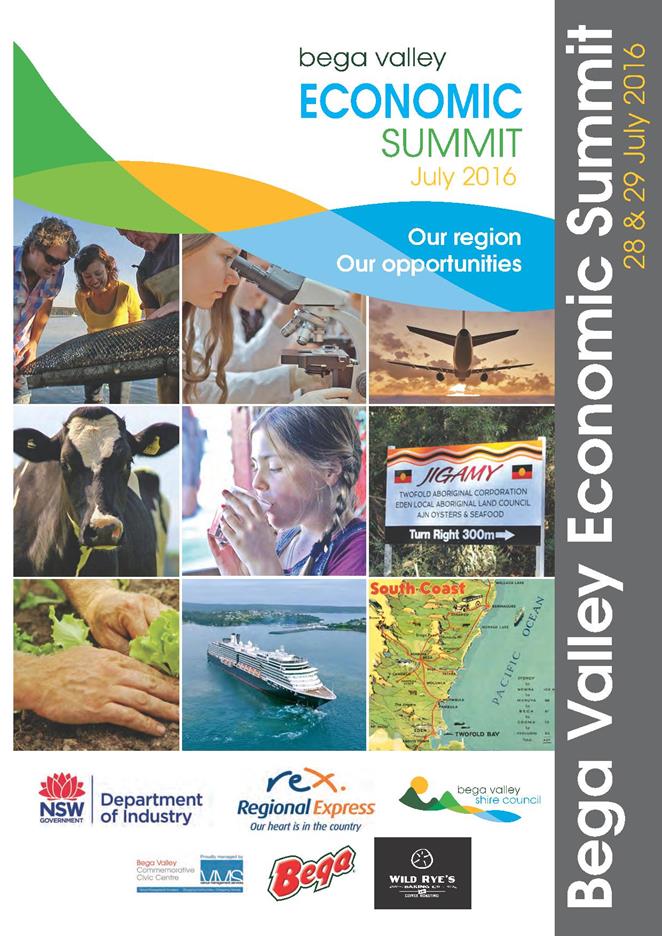

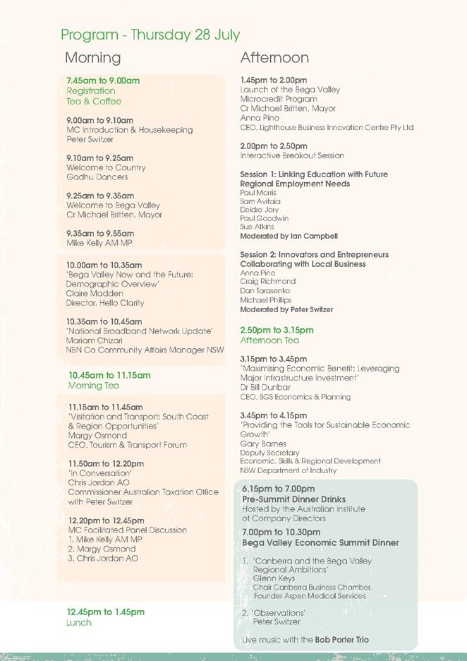
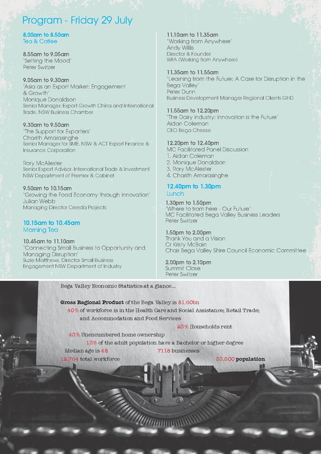
|
Council
|
14 December 2016
|
|
Item 11.3 - Attachment 2
|
Bega Valley Economic Summit Post Event Survey
|
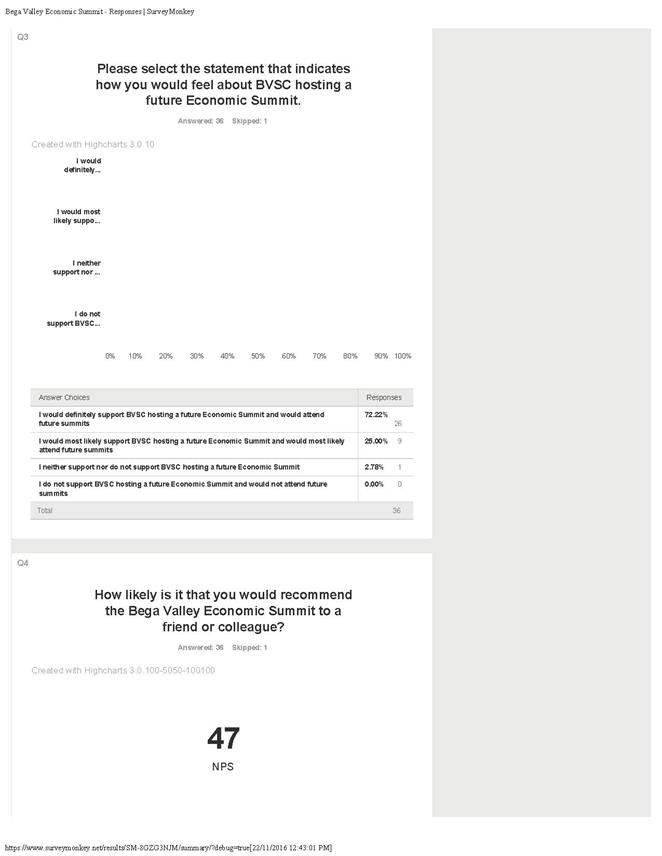
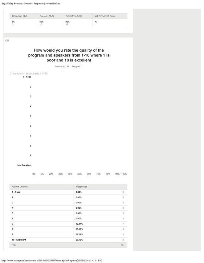
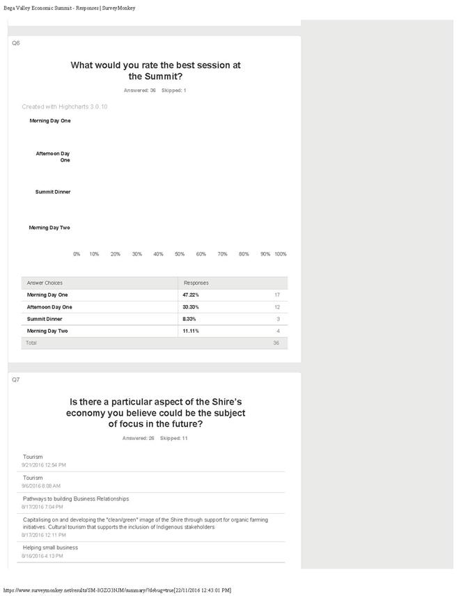
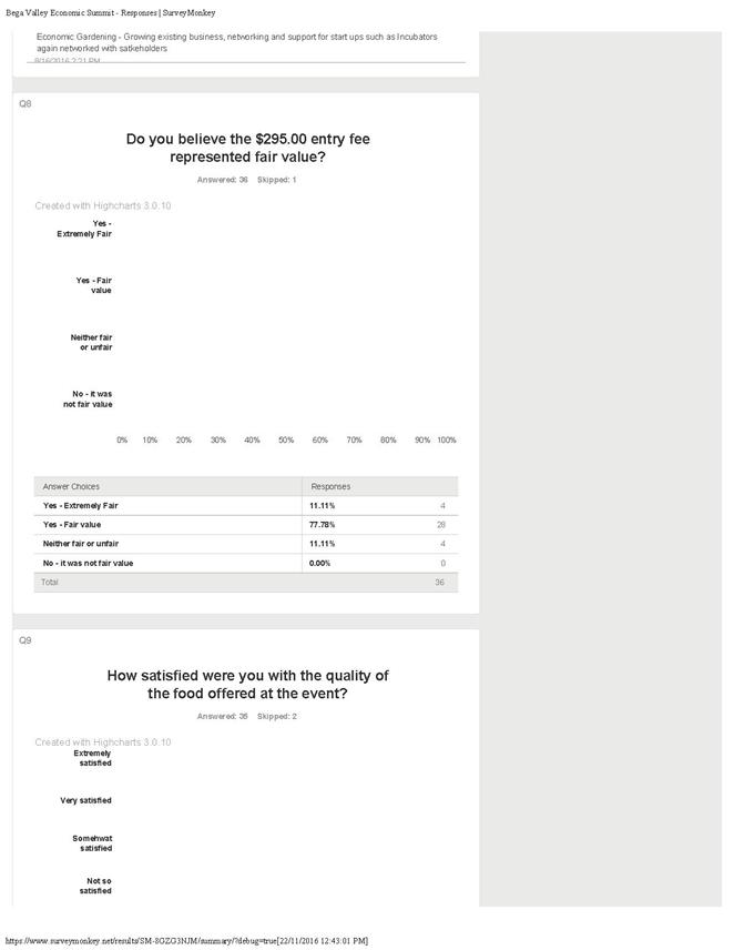
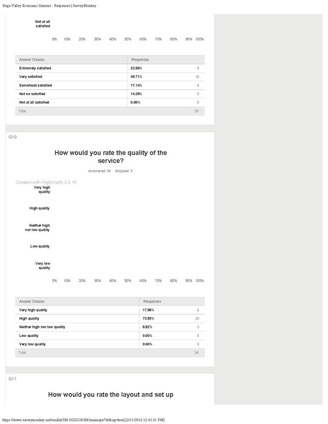
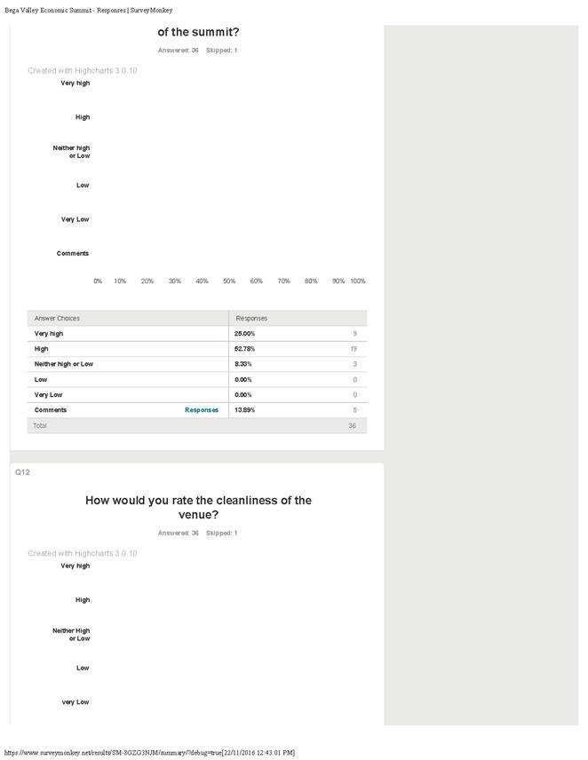

|
Council 14
December 2016
|
Item 11.4
|
11.4. Request to
lease a section of unformed road reserve and permanent road closure at Bermagui
Council has received a
request from a property owner in Bunga Street, Bermagui to lease a section of
surplus road reserve adjoining his property in order to construct a commercial
business premises. Permanent road closure of this section of road reserve
is also being sought, with the proposed lease to be an interim measure until
the road closure process is complete.
Director Strategy and Business Services
Background
Mr Andrew Haydon attended a Development Advisory Panel (DAP)
meeting on 3 December 2015 to discuss his development proposal prior to
lodgement of a formal Development Application (DA). One of the key issues
raised by Council officers at that meeting was the draft design as presented
would result in vehicles exiting the proposed carparking area, by reversing out
onto an unformed Council road reserve on the southern boundary of the subject
site. This would not be supported by Council’s Development
Engineers, as vehicles would need to enter and exit the site in a forward
direction. Mr Haydon was advised that an opportunity may exist for
Council to consider leasing a section of the road reserve, with the option of
future road closure and purchase of the land required from Council.
On the request of Mr Haydon, Council officers investigated
the request to use the adjoining road reserve and on the basis there were no
apparent obstacles to such a proposal, provided in-principle support to the
lodgement of a DA so that the proposal could be fully assessed. As Mr
Haydon’s DA is in the final stages of assessment, formal Council approval
to the proposed lease (and subsequent road closure) is now being sought.
A plan of the section of surplus road reserve which is the subject
of the proposed lease and permanent road closure application appears below.
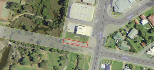
Issues
Legal
Mr Haydon is the owner of Lot 6 Section 17 DP 758095,
located at 26 Bunga Street, Bermagui. A 20 meter wide section of Council
road reserve adjoins the southern boundary of Mr Haydon’s land. The
portion of road reserve which is required to be leased to facilitate his
development is approximately 253.5m2 in size.
Section 153 of the Roads Act 1993 provides that a
roads authority may lease land comprising a public road to the owner of land
adjoining the public road if it is not being used by the public as road.
The term of any such lease, together with any option to renew, must not exceed
five years and may be terminated by the roads authority at any time and for any
reason. Mr Haydon however would like to progress with an application for
permanent road closure as soon as possible, rather than lease the section
required on a long term basis.
If Council consent is granted to the proposed lease and road
closure, officers will prepare the lease documentation required and commence
the public notification process. Once the lease has been entered into,
the road closure assessment process can commence and a road closure application
lodged with Crown Lands for final approval. If approved by Crown Lands
and vested in Council, a plan of first title creation will be prepared and then
transferred to the applicant upon payment of the agreed compensation. The
applicant will be required to execute a formal Deed of Agreement which will
provide that upon transfer, the portion of closed road will be consolidated
with the applicant's adjoining parcel of land.
Strategic
Policy
The proposed lease would be considered commercial in nature
and would therefore not qualify for a rebate off market rental under
Council’s Rental Assessment and Rebate Procedure.
Asset
Due to the topography of the road reserve site, it would be
difficult to construct a road in that location. There is a constructed
minor pedestrian linkage within the road reserve and the site has been filled
over the years as it fell away steeply to the south. The Bermagui Golf
Course is the only other adjoining property to the road reserve, with the Club
already having a major access route off Tuross Street. The lease and road
closure proposal only relates to a 6m wide section of the existing road reserve,
so the remaining 14m of reserve could be retained for pedestrian access to the
golf course if required. Council's Transport Engineering Team have confirmed
they see no future need for the road reserve and have no objections with the
eventual disposal of this section of the reserve.
There is also a rising sewer main located within the section
of road to be leased and purchased by Mr Haydon if the road closure application
is successful. A condition of the road closure would be for either
permanent relocation of that main (at the applicant's expense) or creation of a
suitable easement to the benefit of Council in order to protect our
asset. The applicant has been made aware of this issue and should make
his own enquiries with Council’s Water and Sewer Team as to what their
requirements would be.
The Roads Act 1993 provides that only structures of a
temporary nature, such as fencing which can be easily demolished or removed,
may be erected on road reserve. The development proposal does not include
an intention for any structures to be built on the section of road reserve as
it is to be used for access and egress purposes only.
Consultation
Under Section 154 of the Roads Act 1993, public
notice of the proposed lease must be published in a local newspaper and served
on the owner of each parcel of land adjoining the length of the public road
concerned. The notice must identify the public road and state that any
person is entitled to make a submission to the roads authority within the 28
day submission period.
If any submissions are received objecting to the proposal, a
further report will be prepared for Council’s consideration. If a
lease is granted, the roads authority must cause notice of that fact to be
published in a local newspaper.
The above process will also be required at a later stage as
part of the road closure proposal, as this would be carried out under a
different section of the Roads Act 1993.
Financial
and Resources
If a lease of the site is approved, the annual lease fee
will be at current market value as determined by an independent valuer.
Accordingly, a market valuation has been obtained and provides an annual rental
of $1,920 (plus GST), with the market value of the lot to be created if the
road closure application is successful, being $32,000 (plus GST).
All costs associated with advertising the lease proposal and
preparation of a suitable lease agreement are to be borne by the applicant.
Similarly, the applicant is responsible for all costs
associated with the road closure application, subsequent transfer, their own
and Council’s legal costs incurred to finalise this matter. In
addition to these costs, the applicant will pay Council the market value of the
land as per the valuation. A copy of the Valuation Report is attached for
information.
Conclusion
As the portion of road reserve proposed to be leased and
then formally closed does not impede access to any adjacent parcels of land and
will not be required for road purposes into the future, it is recommended that
approval be granted to the lease proposal and permanent road closure.
Attachments
1. MVS
Valuation Report
|
Recommendation
1. That
Council publicly advertise the proposal to lease a section of surplus road
reserve adjoining Lot 6 Section 17 DP 758095, Bunga Street at Bermagui to Mr
Andrew Haydon and that a notice be served on the owners of land adjoining the
section of Murrah Street the subject of the proposal, allowing a period of 28
days for any submissions to be received.
2. That
if any submissions are received, a further report be prepared for
Council’s consideration. Alternatively, if no submissions are
received and the Development Application receives consent, Council approve a
two year lease to Mr Haydon of a 253.5m2 section of the road reserve adjoining
his above property at current market rental value.
3. That
Council, as the roads authority, cause notice of the grant of any lease in
the local newspaper under Section 156 of the Roads Act 1993.
4. That
Council also approve in-principle the proposal for permanent closure of this
section of Murrah Street in Bermagui and that Council officers commence
assessment of the road closure application following execution of the interim
two year lease.
5. That
if no objections are received, the road closure application be lodged with
Crown Lands for formal approval.
6. That
the General Manager and/or Mayor be authorised to execute the lease and all
other documentation necessary to effect the road closure and subsequent
transfer of land to the applicant for the agreed compensation and that all
costs associated with both the lease and road closure process be borne by the
applicant.
|
|
Council
|
14 December 2016
|
|
Item 11.4 - Attachment 1
|
MVS Valuation Report
|
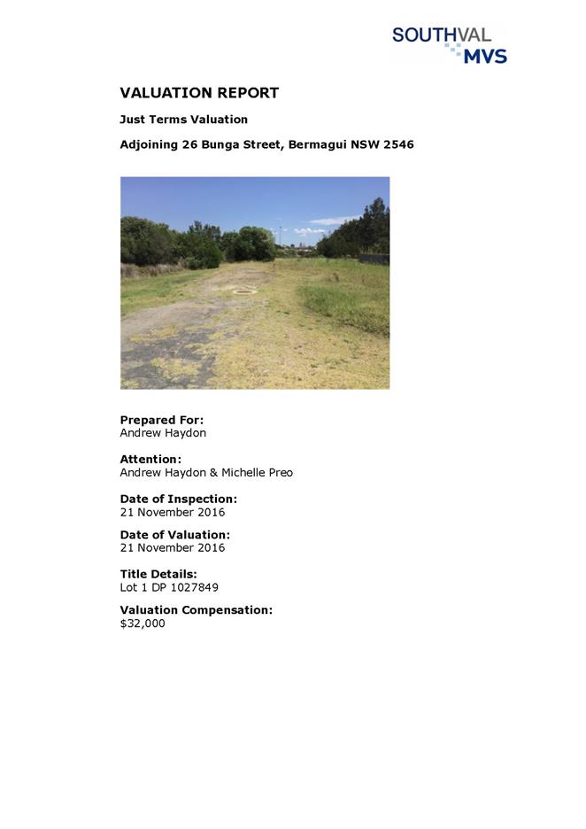
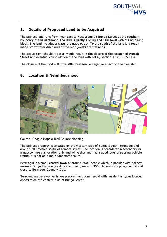
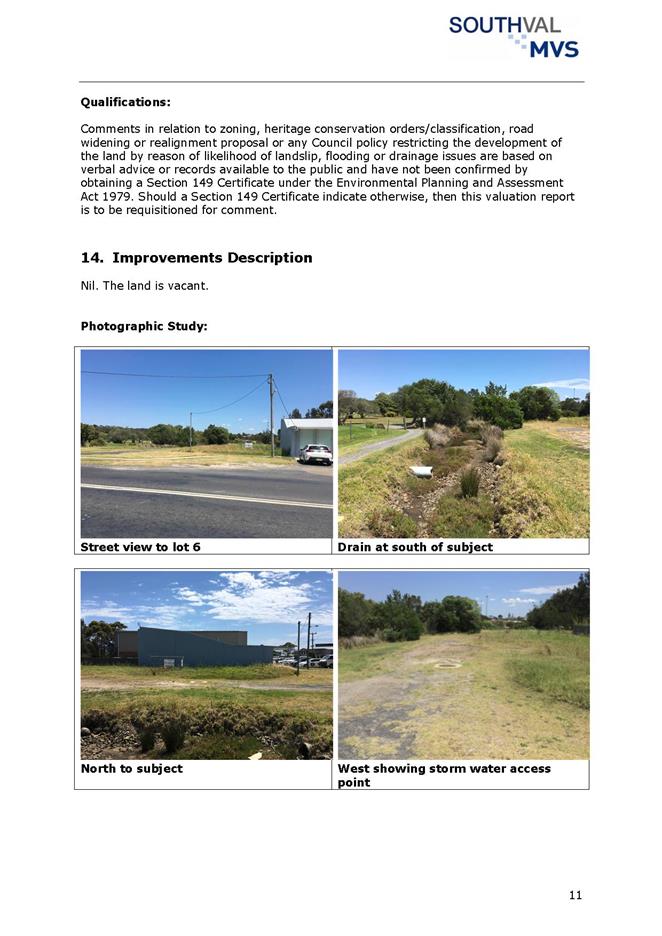
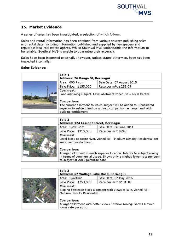
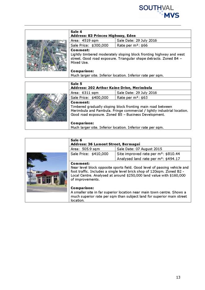
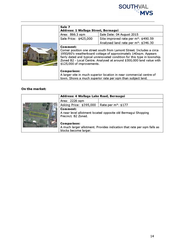
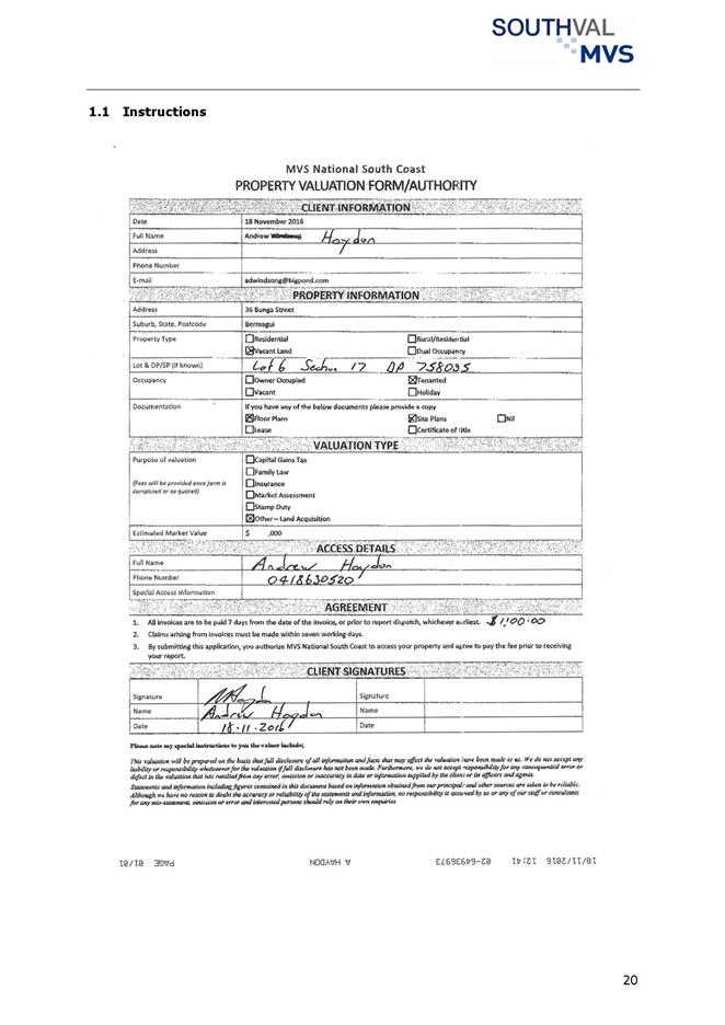
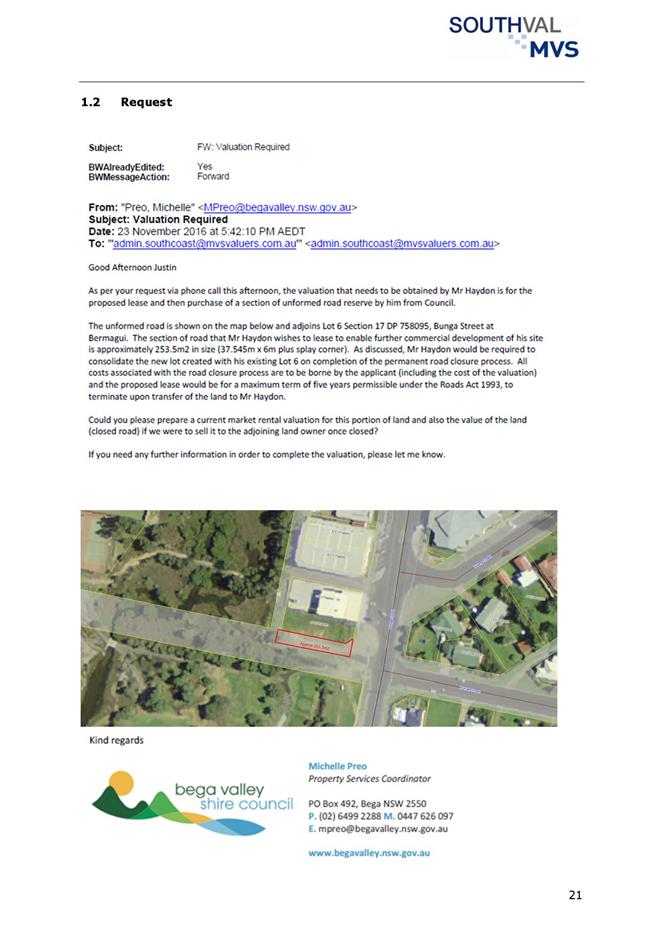
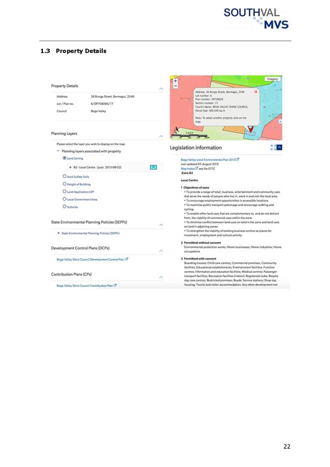
|
Council 14
December 2016
|
Item 11.5
|
11.5. Community
Consultation - Air Service deregulation
In accordance with a Council
Resolution on 12 October 2016, community consultation was undertaken in
relation to a State Government’s proposal to consider deregulation of the
Merimbula – Moruya – Sydney air route.
Director Strategy and Business Services
Background
Between 13 October and 31 October 2016 Council consulted
with the community on behalf of the NSW Department of Transport and
Infrastructure. The consultation was to gain understanding of the
community’s view and sentiment in relation to the State
Government’s proposal to consider deregulation of the Merimbula –
Moruya – Sydney air route.
Issues
Consultation
The consultation came from a Council Resolution from the
Council meeting held on 12 October 2016.
Targeted stakeholders including: airport user groups;
tourism bodies; major employer groups; and town based chambers of commerce,
were advised of the consultation.
The question posed to the community was “Do you agree
with the NSW Government’s proposal to consider deregulation of the
Merimbula – Moruya – Sydney route?”
In addition to the targeted stakeholder consultation, other
methods were used to promote the process throughout the wider community.
Website
promotion:
A quick poll was placed on Council’s website
throughout the consultation period drawing 17 responses (17 in agreement with
the question. 0 in disagreement with the question).
Facebook
promotion:
Council’s social media was used to promote the
consultation using a quick poll facility, resulting in 148 responses (133 in
agreement with the question - 15 in disagreement with the question).
Council
e-news:
Council’s electronic newsletter was used to promote
the consultation and encourage comment.
A total of four (4) written submissions were received, one
(1) of which was an extended comment on Facebook. Three (3) were in agreement
and support of the consideration to deregulate the route. One (1)
submission suggested an alternative solution that Council operate the route
under a Tendered contract.
Conclusion
The General Manager will submit the results of the
consultation to the relevant authority in the NSW Government.
Attachments
1. Summary
of submissions (Councillor Only) (Confidential)
|
Recommendation
That Council note the report and the submissions that will
be forwarded to the NSW Department of Transport and Infrastructure.
|
|
Council 14 December 2016
|
Item 11.6
|
11.6. EOI 104/16
142-144 Imlay St. Eden Purchase, restoration and other conditions of
sale
This
report details the results of an Expression of Interest (EOI) process calling
for proposals to purchase and restore the property situated at 142-144 Imlay
Street, Eden (i.e. the former Hotel Australasia).
Director Strategy and Business Services
Background
Council purchased the 142-144 Imlay Street property on 7
March 2016 following a Resolution to do so at the 24 February 2016 Council
meeting. One of the motivating factors for Council to purchase the former
Hotel Australasia property was the opportunity to preserve and restore a
historic and prominent building in the centre of Eden. The focus of
particular attention is the remarkable façade and the surviving detail
that is presently concealed.
At the 27 April 2016 Council meeting it was resolved an EOI
process be conducted in order to seek interest from both community based and
commercial entities to play a part in the restoration of the former Hotel
Australasia site.
This process netted only one response, which was declined
upon Resolution at the 20 July 2016 Council meeting.
Subsequent dialogue led to Resolution by Council at the 2
November 2016 to hold a further EOI process for private development of the
property, maintaining the laneway in public ownership and stipulating heritage
restoration requirements for the Imlay Street frontage.
EOI documentation was prepared and publicly advertised
stating Council’s overarching objectives as:
· Sell the property
with conditions to a suitable individual(s) or commercial entity;
· Restore the
building with an emphasis on the façade;
· Prepare the
building for occupancy; and
· Commercially
activate the building.
Further specific requirements for development of the
property stated in the EOI documentation included:
· Restoration of the
building’s original facade in accordance with the Bega Valley Shire
Council (BVSC) Development Application presently on public display;
· Demolition of
non-original sections of the building in accordance with the BVSC Development
Application presently on public display;
· Assignment of the
access lane way between Imlay Street and the public car park at the rear of the
property to BVSC for public use;
· Agreement to
commence works within 9 months of settlement; and
· Agreement to
complete all works within 24 months of settlement.
Evaluation criteria and weightings were itemised as follows:
· 50% Financial
offer including agreement to conditions of sale;
· 30% Project
experience, made up as follows:
o Demonstrated ability to meet the
work
o Experience in completing similar
proposed tasks
o QA experience
o Financial ability to undertake
project of this size;
· 20% Local
Community Benefit incorporating recognition of local outcomes and demonstrating
support for local business and community enterprise;
The EOI timeline and key events are summarised in the below
table:
|
Item
|
Responsible Section
|
Date
|
|
BVSC prepare EOI
documents
|
Economic Development
& Procurement
|
Monday, 7 November 2016
|
|
Issue EOI documentation
via e-tendering portal
|
Procurement
|
Tuesday, 8 November 2016
|
|
EOI Period Opens
|
Proponents
|
Tuesday, 8 November 2016
|
|
EOI Briefing
|
Economic Development
& Procurement
|
Tuesday 15 November 2016
|
|
Site Inspection
|
Economic Development
& WHS
|
Monday 21 November 2016
|
|
EOI Periods Closes
|
EOI Evaluation Panel
|
Wednesday, 30 November
2016
|
|
Council Meeting
|
Council
|
Wednesday, 14 December
2016
|
At the close of the EOI period, a total of five (5)
submissions were received. All five have been provided to Councillors under a
Confidential Memo for consideration.
Issues
Legal
The EOI process complies with the Local Government (General)
Regulation 2005.
Policy
As information provided by respondents with their
submissions, in particular price, is “commercial in confidence”,
this information and the details of submissions received are provided to
Council in a Confidential Memorandum, and are not made publicly available.
Social
/ Cultural
The importance of the restoration of the façade and
preservation of the building to the community as evidenced by the group,
Eden’s Australasia is acknowledged by Council.
Asset
142-144 Imlay Street Eden is an asset of the BVSC.
Consultation
Substantial community consultation was carried out as part
of the decision to purchase the property and informed the deliberations of
Council.
Financial
and Resources
An allocation of $1 million was approved as part of the
original Resolution to purchase and secure and remediate the façade of
the property at 142-144 Imlay Street.
|
Funding source
|
|
Amount
|
|
Loan Borrowings
|
$
|
1,000,000
|
Conclusion
This report provides information about the EOI and
evaluation process via Confidential Memorandum and provides recommendations for
Council to consider.
Attachments
1. memorandum
detailing expressions of interest (Councillor Only) (Confidential)
|
Recommendation
1. That
Council accept the recommendations as outlined in the Confidential Memorandum
Attachment.
2. That
authority is delegated to the General Manager to execute all necessary
documentation.
3. That
parties making submissions be advised of Council’s decision.
|
Staff Reports – Infrastructure Waste And Water(Accessibility)
14 December 2016
In accordance with Council’s Code of Meeting
Practice (2011), this section of the agenda will be chaired by Cr Fitzpatrick.
12.1 Proposed
new road names in Bermagui........................................................... 212
12.2 Bega
Valley Local Traffic Committee............................................................... 215
12.3 Waste
Collection Contact and Waste Transfer Contract Extension................. 216
12.4 RFT
91/16 Supply of Components for Chlorinator Safety System Upgrades.... 219
12.5 Acquisition
of Easement over Private Land for Water Supply at Bermagui..... 221
12.6 RFT
93/16 Purchase of Replacement Trucks for Water and Sewer Services Team 241
12.7 Transfer
of surplus equipment and structures at Doctor George Mountain to Bega Access
Radio Incorporated (Edge FM).................................................................................... 243
12.8 RFT
70/16 Construction of a Domestic and Fire Service to Merimbula Airport 246
|
Council 14 December 2016
|
Item 12.1
|
12.1. Proposed new road names in Bermagui
This report is to provide an
update on consultation with the Bermagui Historical Society in regards to the
naming of three lanes and one road in Bermagui.
Director Transport and Utilities
Background
Council officers proposed the naming of three lanes and one
road in Bermagui as Sea Lace Lane, Durvillaea Lane, Laurencia Lane, and
Posidonia Esplanade.
Council resolved at the meeting held on 2nd
November, 2016 the following:
1. That
Council uphold the objections received regarding Sea Lace Lane and readvertise
and notify affected properties of the proposal to name the laneway, which
extends between Wallaga Lake Road and Wapengo Street in Bermagui as McIntosh
Lane, based on the significance of the history relevant to this site. If
no submissions of objection are received, McIntosh Lane will be formally
Gazetted, as per usual process.
2. That
Council defer the naming of the laneways between Lamont and Bunga Street and
Hill and Murrah Streets and the unnamed section of road in Bermagui which
extends north from Lamont Street to consult with the Bermagui Historical
Society on other relevant names.
Consultation
Consultation has occurred with the Secretary of the Bermagui
Historical Society, Denise McGlashan in regards to the above two matters.
The Bermagui Historical Society expressed their gratitude in
regards to changing the proposed Sea Lace Lane to McIntosh Lane and having the
opportunity to suggest additional road names which could be used in future road
naming opportunities.
The Historical Society also considered the other three names
of Posidonia Esplanade, Laurencia Lane and Durvillaea Lane, all based on the
marine environment, and approved of the use of all three proposed names being
Gazetted (see attached).
The Historical Society’s preference for Posidonia
Esplanade was either Ringland, or Tarlinton, however, as both of these names had
already been used throughout the Shire, Posidonia was accepted as a suitable
alternative.
Financial
and Resources
As a result of the Bermagui Historical Society approving the
use of the three road names Posidonia Esplanade, Laurencia Lane and Durvillaea Lane,
a considerable amount of additional funds for advertising and notifying
adjoining property owners of alternative names, has been negated.
Conclusion
That Council note further consultation has occurred with the
Bermagui Historical Society in regards to the naming of roads in Bermagui with
a satisfactory agreement being reached.
Attachments
1. Bermagui
Historical Society approval of proposed road names in Bermagui
|
Recommendation
1. That
Council note the proposed road name of Sea Lace Lane which extends between
Wallaga Lake Road and Wapengo Street in Bermagui has now been readvertised as
McIntosh Lane, with letters also being sent to adjoining property owners
notifying them of the proposal.
2. That
Council note consultation has occurred with the Bermagui Historical Society
in regards to the naming of two other lanes and one road in Bermagui, namely
Posidonia Esplanade, Durvillaea Lane and Laurencia Lane, all based on the
marine environment theme, and that approval has been received from the
Historical Society to now formally Gazette all three road names.
3. That
Council approve the naming of the above roads in Bermagui and Council
officers notify the Geographical Names Board of New South Wales to formally
Gazette the names as indicated above.
|
|
Council
|
14 December 2016
|
|
Item 12.1 - Attachment 1
|
Bermagui Historical Society approval of proposed road names in
Bermagui
|
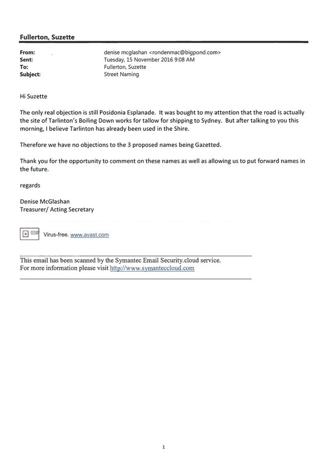
|
Council 14
December 2016
|
Item 12.2
|
12.2. Bega Valley
Local Traffic Committee
The next meeting of the Bega
Valley Local Traffic Committee is scheduled for 7 December 2016. The
recommendations of the Committee will be issued in a Supplementary Agenda for
Council’s consideration, prior to their meeting on 14 December 2016.
Director Transport and Utilities
Background
The Bega Valley Local Traffic Committee will hold their last
meeting of the year on 7 December 2016.
The recommendations of the Committee meeting will be issued
via a Supplementary Agenda to Council, for consideration at the meeting of 14
December 2016. It is a requirement for Council to formally adopt the
recommendations from this Committee prior to action being taken. Due to the
special event approval timeline and sequence, it is necessary for Council to
consider the recommendations for adoption without delay, to allow the event
organisers sufficient time to seek subsequent approvals from other agencies.
The Minutes of the Bega Valley Local Traffic Committee will
also be distributed to Councillors separately.
Attachments
Nil
|
Recommendation
That Council consider the recommendations of the Bega
Valley Local Traffic Committee as noted in the Supplementary Report, to be
distributed after the Committee's meeting on 7 December 2016.
|
|
Council 14 December 2016
|
Item 12.3
|
12.3. Waste
Collection Contact and Waste Transfer Contract Extension
This
report recommends Council extend the Waste Collection and Waste Transfer
Services Contracts for 12 months.
Director Transport and Utilities
Background
Separate five year Contacts for Waste Collection (WCC) and
Waste Transfer Services (WTSC) commenced in July 2012 and will reach their
initial term on 30 June 2017. Both Contracts were awarded on the basis of open
tendering and both Contracts were awarded to Cleanaway.
In relation to the WCC, which includes kerbside garbage,
recycling, garden organics and public litter bin services, the service
specification was carried over from the previous waste collection contract with
two main changes:
1. The
expansion of recycling services to all rural properties that were receiving a
garbage collection service only. This change affected approximately 2,000
properties and diverted a further 2,500 tonnes of waste from landfill over five
years. The value of the landfill space saved is approximately $360,000.
2. Removal
of unattended community recycling points. These facilities were problematic,
primarily due to the high frequency of servicing required and the amount of
illegal dumping and contamination the facilities attracted. They were the
subject of contractual dispute with the former contractor Watts Waste. The
provision of recycling services to rural properties was considered to offset
the removal of these unattended facilities.
The WTSC has been the subject of significant planned change
over the past five years, including construction of new waste transfer
facilities at Merimbula in 2014, at Bermagui in 2016 and soon at Eden in 2017.
These changes deliver on Council’s Strategy to operate a single landfill,
the Central Waste Facility, serviced by waste transfer facilities throughout
the Shire.
There are a number of significant considerations for Council
in the delivery of these services into the future. The first is the lead time
required to formulate a specification, procure the services and allow
sufficient time for a (potentially) new contractor to establish premises,
acquire vehicles, recruit staff, etc. The timing of the Local Government
Elections and the importance of engaging the new Council and the community in
meaningful discussion about the level of service, has meant that a tender
process and an adequate contractor mobilisation period is unlikely to be able
to be achieved prior to 30 June 2017.
There is also potential to enter into dialogue with other
Councils through the new Joint Organisations proposed for local councils or at
least to consider joint tender processes which may lead to considerable
procurement benefits. It is expected that the new Joint Organisations will be
enacted to commence on 1 July 2017 and the extension will allow time for this
opportunity to be investigated.
For these reasons, it is recommended both Contacts are
extended for a period of one year in accordance with the provisions of the
Contracts.
Issues
Legal
Both Contracts contain provisions allowing extension of up
to two years at the sole discretion of the Principal. Both services were
procured through a competitive tendering process in compliance with the Local
Government Act 1993 and Regulation.
Strategic
Waste collection contracts are by necessity long term, with
five years considered to be a minimum to allow for effective amortisation of
plant and equipment. It is therefore necessary to look ahead and consider how
these services are to be delivered to meet Council’s Strategic
objectives. Such considerations include:
Frequency of collections:
Garden organic collection service could be increased from four-weekly to
fortnightly.
Bin sizes and configurations:
Council could offer more flexibility to residents, recognising such a change
would increase management complexity with potential cost and resource
implications.
Container deposit scheme:
The impact of the scheme on the kerbside recycling system should be considered
in the formulation of any new contract.
Consumption of landfill
airspace and recovery of resources: The WCC can be modified to
significantly reduce waste going to landfill by inclusion of food waste with
garden organics service. This approach is worthy of close consideration prior
to calling waste collection tenders.
Waste education: The
community may not be adequately aware of the implications of continued reliance
on landfill disposal. Waste education should be integrated with the
collection services.
Scope of services: Council
may wish to incorporate mobile waste transfer services to outlying villages or
kerbside hard waste collection services. Council needs to consider the pros and
cons of having a single contract versus multiple contracts.
Litter bin services:
Measures can be introduced to better manage capacity issues recognising that
litter bins are a costly component of the services and can have a significant
impact on local amenity. The container deposit scheme is also likely to have an
impact on litter bin usage.
Recycling infrastructure: Council
may wish to establish a materials recovery facility (MRF) locally with the
potential economic opportunities such a facility might present.
Multi-Unit Dwellings: Council
should consider modifying the current services provided to this type of premises.
Regional collaboration:
Council’s membership of the Canberra Region Joint Organisation (CBRJO)
may afford some future opportunities through shared services.
Trial services: A contract
extension may also afford Council the opportunity to trial changes, prior to
making a firm long term commitment under a new contract.
Consultation
Council has recently conducted community consultation
through the Understanding Our Place process. Council has also just completed a
community importance and satisfaction survey looking at Council services. The
results of this are due in December 2016. Recognising the outcomes of these
processes Council will need to consider what aspects of community aspiration it
needs to incorporate into the collection services.
Financial
and Resources
The WCC and WTSC cost Council approximately $2.85 million
and $200,000 per annum respectively. Both services were procured through a
competitive tender process.
Conclusion
Council has the opportunity to consider in detail how it
wishes to deliver waste collection services to the community by extending the
WCC and WTSC in the short term.
Attachments
Nil
|
Recommendation
That the General Manager, or in her absence the
Director of Transport and Utilities, execute extensions to Contracts 6/11
Waste Collection Services and 8/12 Waste Transfer Services between Bega
Valley Shire Council and Cleanaway Pty Ltd for a period of one year to 30
June 2018.
|
|
Council 14 December 2016
|
Item 12.4
|
12.4. RFT 91/16
Supply of Components for Chlorinator Safety System Upgrades
This report details the
outcomes of evaluation of Tender 91/16 for the supply of electronic components
for chlorinator safety system upgrades. The report recommends award to the
preferred tenderers.
Director Transport and Utilities
Background
Council operates 12 chlorination facilities which are used
to disinfect drinking water. The chlorine is stored as a gas, in specially
constructed steel cylinders.
Some of our chlorination facilities are surrounded by
residential and other sensitive areas and there is a need to constantly upgrade
equipment and utilise the latest technology to achieve outstanding safety and
operational outcomes.
This tender specifies equipment needed to detect
“fugitive” chlorine gas and issue an alarm to our officers through
the existing telemetry and alarm system. The equipment will also automatically
close the chlorine gas bottles at the valve stem, using a small motor.
The tender is for supply of equipment only. Installation and
commissioning will be completed by Council officers.
Tender process
On 11 October 2016, Council invited tenders for the supply
of equipment detailed above. Tenders were advertised online on Tenderlink, in
local media and in the Sydney Morning Herald. The tender document described two
packages of work. At the close of tender a total of three organisations had
submitted offers. Two organisations submitted non-conforming offers, in
addition to conforming offers. The offers submitted were as follows:
|
Tenders
|
|
Name
|
Package 1
|
Package 2
|
|
Hydramet
|
Offer submitted
|
Offer submitted
|
|
Hydramet (Non-Conforming)
|
Offer submitted
|
Offer submitted
|
|
IXOM
|
Offer submitted
|
Offer submitted
|
|
Superior Water
|
Offer submitted
|
|
|
Westwater
|
Offer submitted
|
Offer submitted
|
|
Westwater
(Non-Conforming)
|
|
Offer submitted
|
Tenders were assessed based on conformity to the
specifications and price.
Issues
Legal
Council has an obligation to operate its chlorination
facilities in a professional and competent manner. The equipment purchase will
help achieve safety and operational objectives.
Asset
The proposed equipment purchase supports asset management
capital renewal objectives. Funding for the equipment will be drawn from the
Water Fund asset replacement reserve under the approved 2016/17 year Budget.
Conclusion
In conclusion, it is recommended the preferred tenders for
each package be accepted as providing the best overall value to Council.
Attachments
1. RFT
91/16 Confidential Memorandum to Councillors (Councillor Only) (Confidential)
|
Recommendation
1. That
Council accepts recommendations as outlined in the confidential memorandum.
2. That
Council accept the tender for Package 1 from <insert> in the amount of
$<insert> (including GST), and for Package 2 from <insert> in the
amount of $<insert> (including GST), in relation to contract for the
works described in Tender RFT91/16, subject to variations, provisional sums
and prime cost items.
3. That
Council authorise the General Manager, or in her absence the Director of
Transport and Utilities, to execute all necessary documentation.
4. That
other tenderers be advised of Council’s decision.
|
|
Council 14 December 2016
|
Item 12.5
|
12.5. Acquisition of
Easement over Private Land for Water Supply at Bermagui
Necessary
water supply upgrade works have been carried out in Bermagui and the
acquisition of an easement through private property is required to conclude
matters associated with construction of the Nutley’s Creek Reservoir.
Director Transport and Utilities
Background
Council is working to improve water supply in
Bermagui. Part of this work involves construction of a new water storage
reservoir, which will replace five existing reservoirs and one pump
station. The reservoir located on Nutley’s Creek Road is part of
Bega Valley Shire Council’s long term water strategy, providing increased
water security to the Bermagui area and improving water pressure in the
township.
The easement through private property will be created to
cover three metres of underground water main, to protect and maintain
Council’s asset.
Issues
Legal
It is a requirement under the Local Government Act 1993 that
Council resolve to acquire land and interests in private property.
If Council approval is granted, the acquisition will proceed
by way of agreement with the affected landowner and a Deed of Agreement will be
entered into, setting out the undertakings to do all things necessary to effect
registration of the easement. The Deed and Section 88B Instrument
documentation have been prepared by Council’s solicitor, and all costs
associated with creation and registration of the easement will be borne by
Council.
The surveyor appointed by Council has completed the required
survey and prepared the plan of easement for water supply, to ensure
Council’s easement requirements are met.
Strategic
According to the Water Supply Code of Australia the
“water agency” (Council) is responsible for defining acceptable
pressures in water pipes. In the Strategic Business Plan a target
pressure of between 200kPa and 900kPa is defined. This is consistent with
the desirable range suggested in the Water Supply Code of Australia.
Most customers will experience improved pressure and flow,
noting that some properties in Bermagui do not currently achieve the minimum
200kPa pressure. After the new reservoir is commissioned, most customers
will enjoy pressures above 200kPa and no properties will exceed 900kPa
pressure.
Asset
Creation of the easement for utilities will enable the use,
maintenance and upgrade to infrastructure and cater for future services that
may be required to be installed.
Consultation
Council officers have been in consultation with the owners
of Lot 60 DP 1193819 and have obtained their consent to the creation of the
easement.
Financial
and Resources
RW Surveying prepared a Valuation Report to determine an
amount to be paid for compensation to the landowner for creation and ongoing
maintenance of a water supply pipeline and associated infrastructure, in
accordance with principles of the Land Acquisition (Just terms Compensation)
Act 1991. The valuation determination is for an amount of $5,890.
There will be legal fees payable by Council to finalise the
easement documentation and arrange registration on title. The acquisition of
the easement and associated fees can be funded from the Nutley’s Creek
construction project.
Council property officers and external legal providers
will be involved in finalising the relevant paperwork and effect registration
at NSW Land and Property Information (LPI).
Conclusion
Council approval is required to progress the acquisition of
the easement for water supply over private land and execute the required
documentation.
Attachments
1. RW
Surveying Valuation Report Lot 60 DP 1193819 Nutley's Creek Road, Bermagui
2. Plan
of easement for water supply within Lot 60 DP 1193819
|
Recommendation
1. That
the proposed Easement for Water Supply 12.665 wide over Lot 60 DP 1193819 set
out in the attached Draft Plan be acquired by consent of the owner of Lot 60
DP 1193819 for the purposes of Water Supply.
2. That
the General Manager be delegated authority to execute the necessary
documentation to effect the acquisition of the abovementioned interest.
|
|
Council
|
14 December 2016
|
|
Item 12.5 - Attachment 1
|
RW Surveying Valuation Report Lot 60 DP 1193819 Nutley's Creek
Road, Bermagui
|
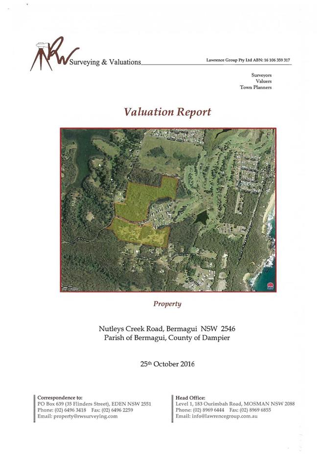
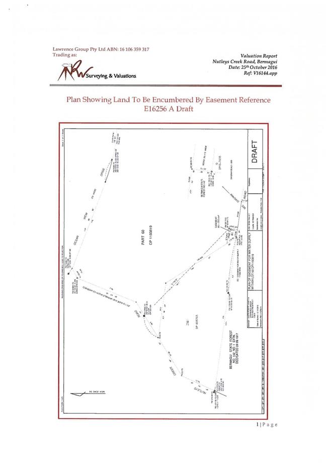
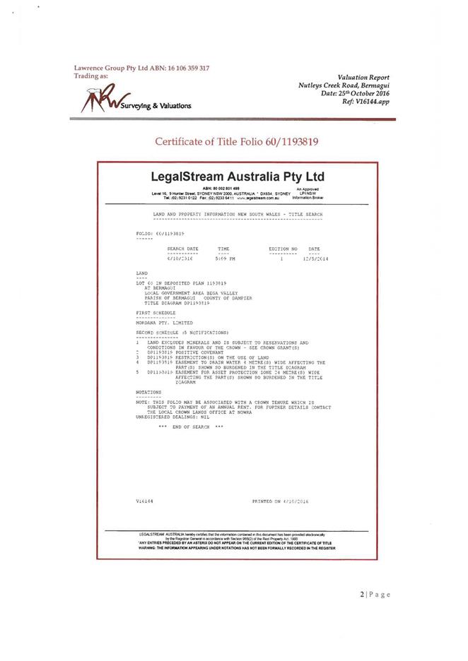
|
Council
|
14 December 2016
|
|
Item 12.5 - Attachment 2
|
Plan of easement for water supply within Lot 60 DP 1193819
|
|
Council 14
December 2016
|
Item 12.6
|
12.6. RFT 93/16
Purchase of Replacement Trucks for Water and Sewer Services Team
This report details the
procurement of replacement trucks for Council’s Water and Sewer Services
Team and recommends the preferred supplier. The trucks are identified as plant
number 222502, 222602, 222802 and 232002 in Council’s Fleet system.
Director Transport and Utilities
Background
Council’s ten year replacement program indicates four
existing Water and Sewer Services (WSS) trucks are due for replacement this
financial year.
The trucks and their associated equipment are vital in the
maintenance of Council’s water and sewer network and are utilised every
day. Council's Fleet Facilities officers held discussions with WSS staff to
determine the operational requirements for the replacement vehicles and develop
a scope to put out to market.
Market research indicated that Iveco, Mercedes and Ford had
trucks within their ranges that were the most likely to meet WSS job
requirements.
Technical specifications were created and a Request for
Tender (RFT 93/16) was submitted through Tender Link with a closing date of 21
October 2016. Council’s Supply Services Team reported only one submission
was received for this tender.
Issues
Competitive
Tender Submission
Council’s Vendor Panel procurement system was not
utilised for this RFT as it did not have the likely competitors required for
this request. Therefore Fleet Facilities officers instead used Council’s
Tender Link system via the Supply Services Team to encourage greater competition.
Despite this attempt to attract a larger audience, on this occasion only one
submission was received, this being an Iveco from Nowra Truck and Tractor.
Conclusion
The vehicles meet all specified requirements and will
provide WSS staff with a suitable platform to perform their duties.
Attachments
1. Confidential
memorandum regarding RFT 93/16 Purchase of Replacement Trucks for Water and
Sewer Services Team (Councillor Only) (Confidential)
|
Recommendation
1. That
Council consider the information outlined in the Confidential Memorandum.
2. That
Council purchase <insert> from <insert> for the total sum of
$<insert> (including GST).
3. That
Council authorise the General Manager, or in her absence the Director of
Transport and Utilities, to enter into direct negotiations with the above
entity with a view to entering into contracts in relation to the subject
matter of this report in accordance with Clause 55(3)(i) of the Local
Government Act 1993.
4. That
Council authorise the General Manager, or in her absence the Director of
Transport and Utilities, to enter into contracts with any entity identified
through direct negotiations in relation to the subject matter of this report
in accordance with Clause 55(3)(i) of the Local Government Act 1993,
for a period not exceeding three months from the date of approval.
|
|
Council 14 December 2016
|
Item 12.7
|
12.7. Transfer of
surplus equipment and structures at Doctor George Mountain to Bega Access Radio
Incorporated (Edge FM)
This report seeks Council
determination with regards to transfer of surplus telecommunication equipment
and Council built structure located on Doctor George Mountain, to Bega Access
Radio Incorporated (Edge FM).
Director Transport and Utilities
Background
Council has held a Crown Licence under Section 34A of the Crown
Lands Act 1989 for a telecommunications tower and associated equipment
located within Reserve 85476 at Doctor George Mountain for in excess of twenty
years.
Council constructed the small brick bunker and pole located
on the site for use by the Engineering Directorate for our two way repeater
station equipment. The use of this equipment has been redundant for quite
some time (close to fifteen years) however as the structure and equipment is still
located on the site, Council is required to continue to pay the annual Licence
fee to Department of Industries - Crown Lands, unless they are either
demolished or transferred to another party.
Under the terms of the Head Licence held by Council, co-occupants
are permitted to use the site. Council has for many years allowed Bega
Access Radio Incorporated (Edge FM) to utilise the bunker and equipment for
their radio communication purposes. Bega Access Radio Incorporated (Edge
FM) is willing to take ownership of the surplus structure and equipment and
take over tenure of the Crown Licence which will relieve Council from paying
the annual Licence fee.
Department of Primary Industries - Crown Lands has advised
the process for Council to transfer tenure and the surplus assets located on
the site is to enter into a Deed of Transfer with Bega Access Radio
Incorporated (Edge FM).
Issues
Legal
Council’s legal representatives have been requested to
prepare a Deed of Transfer with Bega Access Radio Incorporated (Edge FM) for
the purposes of transferring the equipment located on the site at Doctor George
Mountain: being a bunker and pole within Lot 7003 DP 1055124. The terms
of the Deed will include reference to the Crown Licence 412209 to Council
ceasing upon Bega Access Radio Incorporated (Edge FM) entering into a new Crown
Licence with the Department of Primary Industries for the relevant interest being
Site ID 9164; Communications site, Dr George Mountain, within folio identifier
7003/1055124 from 1 January 2017.
Asset
The structure and equipment located on the site are no
longer required by Council. Council’s telemetry and IT equipment
has been relocated to Mumbulla Mountain as the signal is far superior to that
of Doctor George.
Consultation
Council officers have consulted with Bega Access Radio
Incorporated (Edge FM) regarding transfer of the tenure, structure and
equipment and have written confirmation they wish to take over from 1 January
2017. To assist with the process they are having an identification survey
of the communication site prepared as requested by Department of Industries
– Crown Lands.
Financial
and Resources
The current Annual Licence fee payable to Department of
Primary Industries – Crown Lands is $1,514 plus GST. To relieve
this burden it is recommended Council do all things possible to affect transfer
to Bega Access Radio Incorporated (Edge FM) for a nominal fee of $1.
Demolition of the equipment is estimated to cost well in excess of the cost of
legal fees to affect transfer.
Bega Access Radio Incorporated (Edge FM) is arranging for an
identification survey of the communication site to be prepared. Council
will be responsible for legal fees associated with preparation of the Deed of
Transfer.
Council Property officers and external legal providers will
be involved in finalising the relevant paperwork to affect the transfer.
Conclusion
As the telecommunication equipment is surplus to
Council’s needs and without demolition of structure and equipment, will
continue to be required to pay the Annual Licence fee to the Department of
Primary Industries – Crown Lands. It is recommended Council transfer the
tenure, structure and equipment to Bega Access Radio Incorporated (Edge FM) for
a nominal fee of $1.
Attachments
Nil
|
Recommendation
1. That
Council enter into a Deed of Transfer with Bega Access Radio Incorporated
(Edge FM) for the purposes of transferring the Council owned structure and
equipment located on the site at Doctor George Mountain, being a bunker and
pole within Lot 7003 DP 1055124.
2. That
the General Manager and/or Mayor be delegated authority to execute the
necessary documentation to effect the transfer of the abovementioned
interest.
|
|
Council 14 December 2016
|
Item 12.8
|
12.8. RFT 70/16
Construction of a Domestic and Fire Service to Merimbula Airport
This report
details the outcomes of evaluation of Tender 70/16 for the construction of an
upgraded domestic and fire water service to Merimbula Airport. The report
recommends award to the preferred tenderer.
Director Transport and Utilities
Background
The construction of these services upgrades the water supply
to the fire service and water main, commensurate with site development for the
site and in accordance with current standards and is necessary for the next
stage of the Merimbula Airport renewal works to commence.
The proposal involves airside and landside works along the
fence line of the airport and includes: under road and under taxiway boring;
installation of water mains; a pumping shed; and water tanks. The design
of the water services will accommodate regulatory fire suppression and water
use requirements. The tender specifies pipework, structures and
plant needed to achieve the standard required for a regional airport. The
tender is for the supply and construction of the works.
Issues
On 25 October 2016, Council invited tenders for the supply
and construction of the services detailed above. Tenders were advertised
online on Tenderlink, local media and in the Sydney Morning Herald.
Tender documentation comprised a scope of works, tender schedules, general and
special conditions of contract, specifications and drawings. Three
potential tenderers attended a compulsory pre-tender on site briefing. At
the close of tender a total of two organisations had submitted offers.
There were no non-conforming offers.
|
Tenders
|
|
Cappello Commercial
Hydraulics & Civil Pty Ltd
|
Offer submitted
|
|
RD Miller Pty Ltd
|
Offer submitted
|
Tenders were assessed based on
conformity to the specifications and price.
Legal
Council has an
obligation to ensure a compliant water supply to Merimbula Airport for
firefighting and domestic use purposes.
Asset
The proposed works supports current usage of the site,
existing planned upgrades to the runway and terminal, and inadvertently
supports the leasing requirements for general aviation. Funding of the
project is sourced from the Restart NSW funding provided specifically for this
purpose and from Council’s Airport Reserves. The scope of works
includes positioning the two 3.6 metre high x 12 metre diameter concrete
water tanks (required for the fire system) in a location that is readily
accessible for firefighting purposes, facilitates unimpeded future use of the
existing site, and very importantly, protects the visual amenity of the airport.
Financial
and Resources
The panel
identified the funding sources for the project comprises:
|
Funding source
|
|
Amount
|
|
NSW Restart program from
the funding allocation of $971,678
|
$
|
883 000
|
|
Council’s Airport
Reserves (as at 30 June 2016)
|
$
|
254 000
|
Acceptance of the least-cost conforming tender will allow
the works to be completed and funded via the Restart program and
Council’s Airport Reserve.
Conclusion
It is
recommended the preferred tender be accepted as providing the best overall
value to Council.
Attachments
1. Confidential
Memorandum to Councillors (Councillor Only) (Confidential)
2. Confidential
Tender Assessment Matrix (Councillor Only) (Confidential)
|
Recommendation
1. That
Council accepts the recommendations as outlined in the Confidential
Memorandum
2. That
Council accept the tender from <insert> in the amount of
$<insert> including GST for works described in RFT 70/16 Construction
of a Domestic and Fire Water Service to Merimbula Airport.
3. The
authority is delegated to the General Manager, or the Director Transport and
Utilities in absence of the General Manager, to execute all necessary
documentation.
4. The
other tenderer be advised of Council’s decision.
|
Staff Reports – Governance And Strategy (Leading
Organisation)
14 December 2016
In accordance with Council’s Code of Meeting
Practice (2011), this section of the agenda will be chaired by Cr Tapscott.
13.1 Council
Meeting Dates 2017............................................................................. 250
13.2 Results
of 2016 Community Survey................................................................... 252
13.3 Exhibition
of Draft Community Ambitions........................................................ 256
13.4 Adoption
of the Code of Meeting Practice....................................................... 261
13.5 2017
Bega Valley Shire Citizen and Young Citizen of the Year Award ............ 291
|
Council 14 December 2016
|
Item 13.1
|
13.1. Council Meeting Dates 2017
Under Section 9 of the
Local Government Act the Council is required to publicise when it will hold its
meetings.
General Manager
Background
Following the Local Government Election held on 10 September
2016 a survey was undertaken of the newly elected Councillors.
The purpose of the survey was
to assist in determining the most suitable meeting time and date for Council
meetings to allow maximum Councillor attendance and accessibility for members
of the community.
The survey indicated the most appropriate date and time for
future meetings, to facilitate councillor availability and community members to
attend or watch via Council’s Live Streaming application was to continue
as every third Wednesday at 2.00pm.
This option has been included
in Council’s Code of Meeting Practice which was publicly exhibited for
submissions. Following the exhibition period the revised Code of Meeting
Practice is to be adopted.
Council is required to hold at least ten meetings per year
under the Local Government Act (1993). It is proposed no meetings
be held during the months of January and July. The proposed dates
outlined below would allow for fifteen meetings in 2017.
The
proposed meeting dates for 2017 are:
|
Wednesday, 1 February 2017
|
Ordinary
|
|
Wednesday, 22 February 2017
|
Ordinary
|
|
Wednesday, 15 March 2017
|
Ordinary
|
|
Wednesday, 5 April 2017
|
Ordinary
|
|
Wednesday, 26 April 2017
|
Ordinary
|
|
Wednesday, 17 May 2017
|
Ordinary
|
|
Wednesday, 7 June 2017
|
Ordinary
|
|
Wednesday, 28 June 2017
|
Ordinary
|
|
Wednesday, 9 August 2017
|
Ordinary
|
|
Wednesday,30 August 2017
|
Ordinary
|
|
Wednesday, 20 September 2017
|
Ordinary
|
|
Wednesday, 11 October 2017
|
Ordinary
|
|
Wednesday, 1 November 2017
|
Ordinary
|
|
Wednesday, 22 November 2017
|
Ordinary
|
|
Wednesday, 13 December 2017
|
Ordinary
|
Attachments
Nil
|
Recommendation
That
Councillors adopt the meeting dates for 2017 as noted in the report to
Council of 14 December 2016.
|
|
Council 14 December 2016
|
Item 13.2
|
13.2. Results of
2016 Community Survey
IRIS
Research has completed the fourth Community Survey on behalf of Bega Valley
Shire Council and the results are presented to Council.
Director Strategy and Business Services
Background
The 2016 Community Survey was commissioned by Council to measure
the community's assessment of Council’s performance in the delivery of
key services and facilities as well as Council’s overall performance. The
aim of the survey is to provide Council with an understanding of the
perceptions and needs of the local community with respect to both
Council’s services and facilities and to customer service.
The survey objectives were to:
· Measure the
importance of and satisfaction with, services and facilities provided by
Council;
· Compare levels of
satisfaction for Council services and facilities where applicable, with the
benchmark results of 2006 and 2009, as well as IRIS' Council benchmark
database;
· Assist Council in
identifying service use priorities for the community;
· Identify key
drivers of resident dissatisfaction;
· Gain an
understanding of the perception held by residents towards how safe they feel in
their area;
· Identify priority
action areas for Bega Valley Shire over the next 5 to 10 years.
2016 Community Survey - phone
IRIS Research delivered the 2016 Community Survey to a
randomly selected, statistically significant sample of 755 local residents by
phone between 31 October and 3 November 2016. The data was weighted to provide
a representative sample of the region in terms of demographic profile and the
region’s population figures. The survey compliance rate was 62% which,
according to IRIS Research, is a very good result that indicates we have a very
engaged community.
Key findings
The full report of the survey results by IRIS Research will
be made public following the Council meeting.
Key results of the 2016 Community Survey include:
· Overall
satisfaction with Council as an organisation has increased incrementally over
the period since the first survey in 2006;
· Older and younger
residents were more satisfied with Council’s overall performance than
other age groups and satisfaction did not vary by geographic area;
· With the
exceptions of control of cats and dogs in towns and villages, managing healthy
and clean waterways and tourism promotion, Bega Valley Shire Council is
performing below comparable councils in terms of overall satisfaction;
· Council performs
better on delivering services and facilities compared with decision making;
· Services related
to the Leisure and Recreation section are all rated as important with the
provision of sportsgrounds and venues, swimming pools, summer life guards
services that exceed resident expectations;
· The importance of
the development and operation of Merimbula Airport and protection of European
heritage values and buildings and satisfaction with promoting economic
development and business growth have statistically increased from previous
surveys;
· Most Environmental
Services meet resident’s expectations;
· A number of
services that fail to meet resident’s expectations relate to the
Transport and Utilities Group;
· The service
category with the most significant impact on people’s perception of
Council as an organisation is Transport and Utility Group services.
Table 1 contains a summary of performance of Council
services and Council as an organisation in terms of meeting resident’s
expectations extracted from the IRIS Research survey results.
Table
1. Summary of performance of Council services and Council as an organisation
|
Services that meet
expectations
|
Services that do not
meet expectations
|
|
more
important
|
less important
|
more
important
|
less important
|
|
Sports
grounds and venues
|
Children
|
Weed
control
|
Young people
|
|
Parks and
playgrounds
|
Cemeteries
|
Planning
towns and villages
|
Disabled
|
|
Swimming
pools (quality)
|
Library services
|
Way land
being developed
|
Elderly
|
|
Foreshore
areas
|
Regional Gallery
|
Balancing
development and environment
|
Families
|
|
Summer
lifeguards
|
Swimming pools
(provision)
|
Planning
for future of Shire
|
Cultural activity and
connection
|
|
Environmental
health regulation
|
wharves and jetties
|
Economic
development & business growth
|
Community halls
|
|
Healthy
and clean waterways
|
Boat ramps, pontoons
etc.
|
Sealed and
unsealed roads
|
Council reserves
|
|
Bushfire
risk on Council land
|
Septic services (regulation)
|
Public
toilets
|
Car parking (regulation)
|
|
Protection
of natural bushland
|
Protection of European
heritage
|
Car
parking (provision)
|
Protection of trees
(public & private)
|
|
Environ
monitoring and protection
|
Protection of Aboriginal
heritage
|
Footpaths
|
Building inspections
& development control
|
|
Cats and
dogs (control)
|
Regional Learning Centre
|
Urban
stormwater infrastructure
|
Kerb and guttering
|
|
Reducing
environmental footprint
|
|
Merimbula
Airport
|
Cycleways
|
|
Tourism
promotion
|
|
Strong leadership
& good decisions
|
Rural drainage
infrastructure
|
|
Bridges
|
|
Informing
the community
|
|
|
Town
centres (appearance)
|
|
Responsiveness
to community requests
|
|
|
Rubbish,
recycling and green waste
|
|
Involving
community in decisions
|
|
|
Emergency
events and natural disasters
|
|
|
|
|
Sewer
services
|
|
|
|
|
Water
services
|
|
|
|
IRIS Research recommendations from the survey results
include:
· Services that are
viewed favourably by the community, notably Leisure and Recreation and
Environmental Services, should be promoted within the community;
· Services related
to transport and civil assets have been identified as most in need of immediate
attention;
· There is a need to
improve communication with residents about Council decision making processes
during strategic developments;
· Residents care
about the future of the Shire and are ready to collaborate with Council.
2016 Community Survey - online
An online survey was also conducted through Council’s
website to enable interested community members who were not selected through
the random sampling process to participate.
The online survey was live on Council’s website from
15 November to 5 December 2016. The results of the online survey will be made
public following the adoption of this report.
Issues
Strategic
The results of the Community Survey provide Council with
valuable insight in identifying priority action areas for the delivery of
Council services and facilities in Bega Valley Shire over the next 5 to 10
years. The survey is an important input into the development of
Council’s next four year Delivery Plan.
Operational
Plan
The delivery of the Community Survey has been identified in
the 2016-17 Annual Operational Plan: LO3.2.2.1 ‘Undertake Community
Satisfaction Survey to develop understanding of community satisfaction and
expectations, supporting the development of the Community Strategic Plan
review’
Consultation
The Community Survey was delivered by phone, with IRIS
Research utilising samples proportionate to the composition of the local
community with respect to age, gender, ethnicity in accordance with the most
recent ABS Census. It also provided appropriate samples of each of the five districts
within the Shire, and appropriate samples of urban, village and rural areas.
IRIS Research also provided Council with the facility for
residents to undertake the Community Survey online to permit other interested
eligible local residents to participate.
IRIS Research will be presenting the findings of the survey
to Council on the morning of December 14, 2016. The survey results will then be
tabled in association with this report. Once this report has been adopted,
Council will make all reports available to the public, with printed copies
available for anyone attending the IRIS public information session from 6pm on
December 14, 2016 at the Bega Valley Commemorative Civic Centre in Bega.
Financial
and Resources
The Community Survey is an identified and budgeted item
within the 2017 Annual Operation Plan and Budget.
Conclusion
The results of the 2016 Community Survey provide Council
with a balanced view of the community’s expectations and satisfaction
with regards to service delivery by Council.
The survey results will enable Council to identify priority
action areas for the delivery of Council services and facilities in the Bega
Valley Shire over the next 5 to 10 years by providing Council with
statistically representative information which is used to inform:
· discussions on
current service areas and levels of service;
· decision making on
the direction and commitment for the 2017-2021 Delivery Plan;
· the targeted
engagement stage of Council's Community Strategic Plan review;
· various other
aspects the Council’s future planning.
Attachments
Nil
|
Recommendation
That Council note the results of the 2016 Bega Valley
Community Survey by IRIS Research and publish the report to Council’s
website along with the results from the online survey.
|
|
Council 14 December 2016
|
Item 13.3
|
13.3. Exhibition of
Draft Community Ambitions
The
draft Community Ambition statements for the upcoming Bega Valley Community
Strategic Plan 2040 have been publically exhibited and the results of the exhibition
is presented for Council’s consideration.
Director Strategy and Business Services
Background
From the information contained in the Understanding Our
Place Report, a series of draft ‘community ambitions’ was
compiled which aimed to reflect our community's main priorities and
aspirations. When finalised and adopted, these community ambitions will form
the cornerstones of the Bega Valley Community Strategic Plan 2040.
The draft community ambitions were publically exhibited
prior to the formal public exhibition of the entire draft Bega Valley Community
Strategic Plan 2040 to ensure they adequately reflect the desired future
ambitions of the community and to permit the incorporation of community
feedback before the development of other components of the draft Community
Strategic Plan 2040.
Exhibition of draft Community Ambitions
The draft community ambitions were publically exhibited from
3 November to 1 December 2016. During this period advertisements were placed in
the three local papers, promotional material was published in Council’s
e-news and village newsletters, posters were placed in local cafes, libraries
and throughout Council’s offices and depots, feedback sheets were
provided at the meet the public Councillor session on 9 November, and
promotions were also hosted on Council’s website and Facebook page which
included the capacity for people to provide comments.
The draft community ambitions as exhibited:
By
2040
· Our air and water is pristine and our natural
environment and rural landscapes are preserved;
· Our economy is prosperous, diverse and
supported through innovative and creative businesses;
· Our Shire continues to be an enjoyable, safe
and affordable place to live;
· Our towns and villages are well presented and
provide a range of goods and services that meet local needs;
· Our towns and villages have character and
development throughout the shire remains low density and low rise;
· We are a co-operative, kind and culturally
rich community;
· We are an active and healthy community with
access to good quality recreation and sporting facilities and specialist
medical health care;
· We are an engaged community with a
transparent, consultative and responsive Council;
· We are leaders in sustainable living and
support innovative approaches to resource recovery and the production of
alternative energy and food;
· We are well connected by public transport and
telecommunications services;
· We have good quality roads and a network of
accessible foot and bike paths connects communities throughout the Shire;
· We have meaningful employment and education
opportunities for people in all stages of life.
Feedback on draft Community Ambitions
Written comments received during the ‘meet the
Councillors’ session concerned Council’s role in fire control and a
desire for more music concerts. A comment on Council’s website concerned
an error in the Understanding Our Place Report which has been rectified.
A written submission congratulated Council and noted the
ambitions are very diverse which may create difficult decisions regarding
Council’s Budget, that the overarching importance of climate change on
Council activities and discussed opportunities for taking climate change
seriously.
Operational
Plan
The delivery of the Bega Valley Community Strategic Plan
2040 consultation is an identified activity within the 2016-17 and 2017-18
Operational Plan. The delivery of this activity was designed to take
place over two financial years.
Consultation
The Public Exhibition of the draft Community Ambitions was
in addition to the statutory exhibition requirements for Community Strategic
Plans under the Local Government Act 1993.
Further consultation of the draft community ambitions will
take place throughout the development of the Bega Valley Community Strategic
plan 2040, including the focus groups planned for February 2017 in accordance
with the Community Engagement Strategy for the Community Strategic Plan.
Conclusion
The draft Community Ambitions were developed from
information received by Council during a comprehensive engagement project
involving around 2,000 local people. As such, it is unsurprising that little
feedback was received to the exhibition of the draft Community Ambitions as
they were designed to incorporate all of the major issues raised by the
community.
Ongoing work by Council and the community in developing the
upcoming draft Delivery Plan and Community Strategic Plan will provide
opportunities for revision of the draft Community Ambitions as required. This
includes the focus groups planned for February 2017 which will provide the
community with an opportunity to discuss the draft Community Ambitions.
The draft Community Ambitions will be publically exhibited
again in April – May 2017 within the draft Bega Valley Community
Strategic Plan 2040 which will provide the community with an additional
opportunity to comment on the draft Community Ambitions.
Attachments
1. Exhibition
of Draft Community Ambitions written submission
|
Recommendations
1. That
Council note the public exhibition of the Draft Community Ambition
statements.
2. That
further feedback relating to the Draft Community Ambition statements be
collected by Council staff during the upcoming consultations relating to the
Bega Valley Community Strategic Plan 2040 and any amendments be presented to
Council prior to exhibition of the Bega Valley Community Strategic Plan 2040.
|
|
Council
|
14 December 2016
|
|
Item 13.3 - Attachment 1
|
Exhibition of Draft Community Ambitions written submission
|
|
Council 14
December 2016
|
Item 13.4
|
13.4. Adoption of
the Code of Meeting Practice
Under Section 9 of the Local
Government Act (1993) the Council is required to publicise when it will
hold its meetings.
General Manager
Background
Council resolved at its meeting on 12 October, 2016:
1. That
the revised Code of Meeting Practice be placed on public exhibition for a
period of 28 days with submissions to be received for 42 days.
2. That
following exhibition and receipt of submissions the revised Code of Meeting
Practice be reported to Council for adoption.
3. That
proposed dates and times for Council meetings in 2017 be reported to Council
for adoption at the meeting on 14 December 2016
Previously, Council resolved at its meeting on 30 September
2010 to move to a three weekly meeting cycle, meetings continued to commence at
2.00 pm This cycle that has been in place since 2010 enables staff to prepare
reports required as a result of deputations to the previous Council meeting or
from the regular Councillor briefing conducted on Wednesdays that are not
Council meeting days.
Meeting dates from September 2016 to December 2016 were set
by resolution of Council 29 June 2016. Following the Public Exhibition of
the revised Code of Meeting Practice, a decision should be made on dates for
meeting for the 2017 year. A separate report to this meeting proposes the dates
for 2017.
The revised Code of Meeting Practice presented to Council on
12 October, 2016 was placed on Public Exhibition for a period of 28 days, with
submissions being accepted for a total of 42 days.
One submission was received from the Bega Valley Shire
Residents and Ratepayers Association noting that Council communication would
benefit from providing open workshop sessions on major issues. The comments
were as summarised below:
|
No.:
|
Comment/Observation
|
|
1
|
One way of building greater
community awareness of community issues is to provide opportunities for the
community to become more aware of such issues.
|
|
2
|
The community would
benefit from being better informed on the background of important issues, as
well as understanding the constraints Council Officers are confronted by in
addressing community issues.
|
|
3
|
Improve community
involvement and engagement by allowing residents to attend non-confidential
sessions of Council workshops.
|
|
4
|
Council could publicise
the headline of each item to be addressed during workshops. Such
information being available on Council’s website and distributed as an
E-News item.
|
Councillors have indicated their willingness to consider
open workshops and roving workshops into the future following the conclusion of
the current intensive induction program and community strategic plan
development.
A full version of the submission is attached to this report.
Attachments
1. Submission
in respect of Draft Code of Meeting Practice version 9
2. procedure
5.02.2 Code of meeting practice version 9 publicly exhibited 13 October 2016
|
Recommendation
1. That
Council adopt the advertised Code of Meeting Practice.
|
|
Council
|
14 December 2016
|
|
Item 13.4 - Attachment 1
|
Submission in respect of Draft Code of Meeting Practice
version 9
|
|
Council
|
14 December 2016
|
|
Item 13.4 - Attachment 2
|
procedure 5.02.2 Code of meeting practice version 9 publicly
exhibited 13 October 2016
|
|
Council 14
December 2016
|
Item 13.5
|
13.5. 2017 Bega
Valley Shire Citizen and Young Citizen of the Year Award
Council
has sought nominations for the 2017 Bega Valley Shire Citizen and Young Citizen
of the Year Awards.
Executive Manager Organisational Development and
Governance
Background
For many years Council has selected a Bega Valley Shire
Citizen and Young Citizen of the Year in recognition of outstanding community
services or achievement. These prestigious awards are presented as part
of the Shire’s official Australia Day Ceremony on 26 January each year.
Recipients, their peers, families and nominators are invited
to attend a pre-Australia Day awardee function.
Advertisements calling for nominations commenced on 12
October 2016 and closed on 1 November 2016. All local media outlets, as
well as Council’s website and Facebook page were utilised to help promote
the nomination process. Council also engaged with local schools and
community organisations to encourage submission of nominations.
Copies of each nomination for the Citizen and Young Citizen
of the Year will be provided to the Councillors to assist in the selection
decision making.
Issues
Social
/ Cultural
Only one nomination for each of the Citizen and Young
Citizen of the Year has been received. Council will need to consider their
position in relation to the Awards and potential re-advertising.
Conclusion
The Citizen and Young Citizen of the Year Awards are an
important way for Council to recognise individual contributions and
achievements by members of the local community.
Attachments
1. 2017
Young Citizen of the Year nominations (Councillor Only) (Confidential)
2. 2017
Citizen of the Year Nominations (Councillor Only) (Confidential)
|
Recommendation
1. That
the nominations be deferred to a Closed Session of Council for discussion.
2. That
Councillors consider the nominations received for Citizen and Young Citizen
of the Year and make the decision whether or not to award the nominees with
such awards.
3. That
the successful nominees, their peers/family/nominators be invited to attend
the Australia Day Award Ceremony to receive their Award.
4. That
the announcement of the awardees will be kept confidential until the official
Australia Day program is released.
|
Staff Reports – Finance (Leading Organisation)
14 December 2016
In accordance with Council’s Code of Meeting
Practice (2011), this section of the agenda will be chaired by Cr Bain.
14.1 Certificate
of Investments made under Section 625 of the Local Government Act, 1993 294
|
Council 14 December 2016
|
Item 14.1
|
14.1. Certificate of Investments made under Section 625 of the Local
Government Act, 1993
This report details
Council’s investments during the month of November 2016.
Director Strategy and Business Services
Background
Under the legislation and regulations mentioned below, the
Responsible Accounting Officer must present to Council on a monthly basis the
status of the investments held by Council. The Responsible Accounting Officer
must detail the investments held, and their compliance with both internal
policy and external regulation under the Ministerial Order of Investments.
In accordance with the recommendations made by the Office of
Local Government (OLG) Investment Policy Guidelines published in May 2010, the
Strategy and Business Services Group has made the monthly Investments Report an
attachment to the Business Paper. This allows a stand-alone report to be
published on Council’s website for the public to view without having to
peruse the Council’s Agenda for the relevant meeting.
Issues
Legal
Section 625 of the Local Government Act 1993 (the
Act) determines money may only be invested in a type of investment authorised
by order of the Minister for Local Government and published in the Local
Government Gazette. The most recent Ministerial Order of Investment was
published February 17, 2011.
Clause 212 of the Local Government (General) Regulation 2005
determines the Responsible Accounting Officer must provide Council with a
written report setting out details of all money Council has invested under
section 625 of the Act.
The report must also include a Certificate as to whether or
not the investments have been made in accordance with the Act, the Regulations
and the Council’s Investment Policy.
Policy
Council has an Investment Policy published under Policy
number 5.07. This Policy is reviewed every 4 years by Council and annually by
Council officers.
Council’s current Policy allows for investment of
funds in cash term deposits only with rated Authorised Deposit-Taking
Institutions (ADI’s). Council does not hold any investments in sub-prime
or managed fund products. At this time, Council holds no long term deposits nor
any deposits introduced through an agent.
Financial
The attached report indicates a current investment portfolio
of $50,900,000. These funds can be broken into the following Funds:
|
Table 1: Investments by
Fund $’000
|
|
Fund
|
Sep 2016
|
Oct 2016
|
Nov 2016
|
|
General Fund
|
$12,294
|
$17,294
|
$17,294
|
|
Water Fund
|
$13,486
|
$13,486
|
$13,486
|
|
Sewer Fund
|
$20,120
|
$20,120
|
$20,120
|
In addition, there is $3,262,375 in
uninvested funds in Council’s operating account. There is an additional
$5,000,000 at call investment held in Council’s Transactional Account.
· Each
fund’s allocation can only be utilised on its specific operations. For
example, Water Fund cannot use its financial resources on General Fund
projects, etc.
· Externally
Restricted is defined by purposes that are “restricted” by external
legislation or regulations, such as unspent grants or loans tied to a specific
project, or development contributions held for expenditure in accord with an
adopted s94/s64 contributions plan.
· Internally
Restricted is defined by “restrictions” placed upon the use of these
funds by Council internally, such as asset replacement, weeds, property,
employee entitlements and the like.
· Unrestricted
funds are available for day to day operational uses, or emergencies. Those
funds are reviewed daily for short term investment, depending on revenue cycles
such as rates instalments.
|
Table 2: Restricted Cash
and Investment by Fund $’000
|
|
Fund
|
External Restrictions
|
Internal Restrictions
|
Unrestricted
|
Total
|
|
General Fund
|
$9,512
|
$12,050
|
$3,994
|
$25,556
|
|
Water Fund
|
$3,333
|
$10,153
|
|
$13,486
|
|
Sewer Fund
|
$3,879
|
$16,241
|
|
$20,120
|
The restrictions reported in Table 2 relate to 30 June 2016.
Council formally calculates its Restrictions as at 30 June
each year. These Restrictions are not reset until the following year Financial
Audit. Any movement of funds during the year, is therefore, shown as movement
in unrestricted cash.
There have been expenditures between July and year to date
that will result in reduced restrictions (for example transfers from reserves
to fund capital works), but is not reflected in the above table.
Attachments
1. Investment
Report - November 2016
|
Recommendation
1. That
Council receive and note the attached report indicating Council’s
Investment position.
2. That
Council note the Certificate of the Responsible Accounting Officer.
|
|
Council
|
14 December 2016
|
|
Item 14.1 - Attachment 1
|
Investment Report - November 2016
|
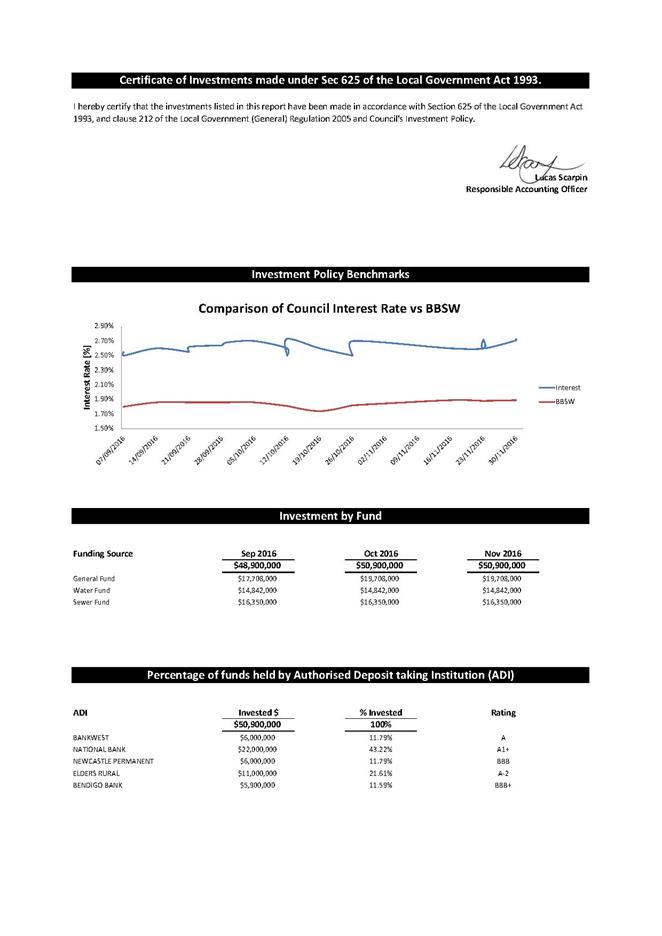
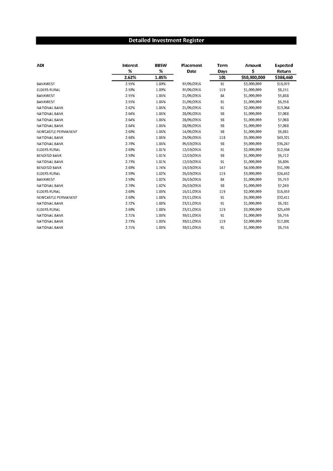
Notices of
Motion
14 December 2016
18.1 Eden
Pool - heat blanket................................................................................... 299
18.2 Safe
Schools Coalition Australia (SCCA)............................................................ 300
|
Council 14 December 2016
|
Item 18.1
|
18.1. Cr Robyn Bain - Eden Pool -
heat blanket
Background
The Eden Swim Club have done a fantastic job at raising
money for the provision of a blanket for the pool to keep heat in and provide
an improvement in swimming conditions and are now only a few thousand dollars
short. This fundraising effort is a display of the commitment the members
of the Eden community have to their pool.
Cr Robyn Bain
Attachments
Nil
Notice of Motion
That Council fund any shortfall in funding for the pool
blanket for the Eden Pool.
|
|
Council 14 December 2016
|
Item 18.2
|
18.2. Cr Cathy Griff -
Safe Schools Coalition Australia (SCCA)
Background
All students have a right to feel safe, be acknowledged and
belong as part of their school community. Schools understand they need to meet
this need and provide supportive and respectful environments that enable
students to maximise their learning potential.
Safe Schools Coalition Australia (SSCA) is a national
network of organisations working with schools to create safer and more
inclusive environments for same sex attracted, intersex and gender diverse
students, staff and families. http://www.safeschoolscoalition.org.au/who-we-are
SSCA provides a range of free support for school staff,
including professional learning, advice and resources. Teachers and mental
health professionals developed the program to address a lack of structural
support for non-heterosexual young people.
SSCA is funded by the Australian Government Department of
Education and Training and nationally convened by the Foundation for Young
Australians (FYA). FYA has partnered with organisations across the country to
provide expert support for schools.
Research shows that bullying, discrimination and isolation
of young people who are same sex attracted, intersex and/or gender diverse
occurs in schools and seriously impacts student wellbeing and achievement.
Research also shows school staff are often unsure of how to address these
concerns and develop strategies to create more supportive environments. Through SSCA, schools can access specialised
support that contributes to the school’s overall approach to student
safety and inclusion – for the benefit of the whole school community.
National and international research shows that a supportive
and inclusive school environment is essential for all students to be healthy
and happy, and to be able to maximise their learning potential.
The SSCA program has two very worthy objectives:
· Firstly, to
prevent homophobia and bullying in schools and promote an inclusive learning
environment.
· Secondly, to
support students who face personal issues in terms of their gender identity and
sexual orientation.
While SSCA has been developed to align with the Australian
Curriculum, schools make their own decision to utilise any of the SSCA
resources and approaches as they see fit. All SSCA resources are hosted online
on the Student Wellbeing Hub.
Statistics from Beyond Blue show up to 50% of transgender
people have attempted suicide at least once in their lives. Same-sex attracted
young people in Australian have vastly higher rates of suicide attempts in
comparison to their heterosexual peers. The average age of a first suicide
attempt is 16 years – often before ‘coming out’.
Why
Safe Schools is Council business
Bega Valley Shire Council resolved to support Marriage
Equality at its Ordinary Meeting of 25 September 2013, and Safe Schools
reflects a similarly ethical acceptance and compassion for non-heterosexual
people. This issue is Council business, being the closest tier of government to
these young people in our community. Council is well placed to provide support
to kids in need and to help change community values. Our civic leadership and
support will hopefully send a strong message to kids who are suffering in
silence.
Bega High School has voluntarily opted in to implement the
Safe Schools program, and our support of them and other young people in the
area is important. At its core, this is a program that is funded with the
objective of reducing discrimination and promoting tolerance.
Numerous Councils have passed similar motions supporting Safe
Schools including: Shoalhaven; Kiama; Forbes; Albury; Inner West Council;
Frankston City Council; Darebin; Hobsons Bay; City of Sydney; City of Port
Phillip; Marrickville; and Leichardt, along with a host of other organisations.
http://www.safeschoolscoalition.org.au/our-supporters/organisations
Testimonials from teachers, students and principals can be
found at http://www.safeschoolscoalition.org.au/our-supporters/testimonials
The Federal Government intends to withdraw all funding for
SSCA starting 2017, which will be devastating for young people, whose schools
are inadequately equipped to deal with this specific type of bullying on their
own.
Cr Cathy Griff
Attachments
Nil
|
Notice of
Motion
1. That
the Mayor and General Manager, on behalf of Council, signs the Safe Schools
Coalition Australia pledge:
“We
believe that schools should provide a safe and inclusive environment for all
students, so that they can learn, grow, and reach their full potential
– free from bullying and discrimination. We pledge to stand up against
homophobia and transphobia whenever we see or hear it. We are proud to
support Safe Schools Coalition Australia and its work to create positive
change for same sex attracted, intersex and gender diverse students, school
staff and families.”;
2. That
Council write to local schools notifying them of Council's support for the
Safe Schools Coalition Australia program.
3. That
Council write to the Federal Government requesting continued funding of Safe
Schools Coalition Australia.
4. That
Council write to the NSW State Government requesting that it follow the
example of the Victorian State Government by funding Safe Schools Coalition
Australia, in the event that the Federal Government fails to do so.
5. That
Council promotes support of Safe Schools Program through Council website and
buildings used by local students and parents, including Council’s
libraries.
|
Questions On
Notice
14 December 2016
19.1 Pambula
Recreation and Showground Reserve................................................ 303
19.2 Tathra
Headland Path budget allocation.......................................................... 304
|
Council 14 December 2016
|
Item 19.1
|
19.1. Pambula Recreation and Showground Reserve
At its Ordinary Meeting on 18
May 2016, Cr Fitzpatrick asked “When will Council receive a report on the
Pambula Sportsground and Showground Reserve, and ensure that the facility
remains in the public interest.”
The question was taken on
notice by the Director Community, Relations and Leisure.
Director Community, Relations and Leisure
Update
The Pambula Public Recreation and Showground Reserve 89209
(the Reserve) is a Crown Reserve (not a Council Reserve) currently managed by
New South Wales Holiday Park Trust (NSWHPT). The management of the Reserve by
NSWHPT was facilitated by Crown Lands.
When the matter was considered by Council at its Ordinary
Meeting on 22 July 2015, in-principle support was provided for this arrangement
with the longer term view of working together with NSWHPT and Crown Lands on
future use of the Reserve. Part of this collaborative approach was the
development of a Memorandum of Understanding (MoU) between Council and NSWHPT.
Council officers have provided feedback and input into a draft MoU; however it
has not been finalised at this time.
As the Reserve has been Gazetted by the New South Wales
Parliament to be managed by the NSWHPT, any report on the Reserve should be
provided by NSWHPT.
Officers recently met with representatives of the NSWHPT to
better understand the current issues and management of the Reserve. NSWHPT were
invited and have agreed to meet with Councillors in early 2017.
Attachments
Nil
|
Council 14 December 2016
|
Item 19.2
|
19.2. Tathra
Headland Path budget allocation
At
its Ordinary Meeting on 23 November 2016, Cr Griff asked could Council officers
investigate the possibility of allocating $40,000 towards The Tathra Headland
Pathway planning requested in recent discussions with the Tathra Headland
Access Group, to enable the project to become shovel ready, and the impact of
that allocation on other projects.
The
question was taken on notice by the Director Community, Relations and Leisure
Director Community, Relations and Leisure
Background
Council officers have worked extensively with the Tathra
Headland Access group, providing support through the provision of existing
reports and data, advice on funding opportunities, and through the direction of
Council in undertaking community consultation. Community consultation showed
overwhelming support for a walking/cycling path on the Tathra Headland.
Capital
works program
Council has a considerable number of existing assets, many
of which are aging and require a program of renewal and potentially upgrades.
Council has strategic planning documents (Asset Management Plans) to help plan
for expected future asset replacement.
There are many good ideas and proposals that come in from
the community through Community Project Proposals and, on occasion, there is a
need to revise work programs and priorities to accommodate unplanned events
such as the June East Coast Low (ECL) storm event. All these need to be
considered in the context of limited Council resources.
Sometimes adding new projects or reprioritising current
projects is required and worthwhile. Typically this would be to take advantage
of an opportunity such as a successful grant funding proposal, skills and
resources offered by community groups, or the opportunity to ‘scale
up’ works to get efficiencies and more works completed in one
‘project’ for not a lot more funding. Adding projects can work particularly
well when the works are related to Strategic Plans and/or asset renewals.
Reprioritising is well worth considering when it is clear Council will be
getting much improved value for dollar.
For a project to be added or move up ‘the list, it
inevitably means other works have to be delayed or deferred; meaning some
people will be disappointed.
The 2017 Leisure and Recreation Capital Works Program
adopted by Council is:
Renewals
Bega Swimming Pool $20k
Renewals
Eden Swimming Pool $20k
Renewals
Bemboka Swimming Pool $30k
Renewals
Candelo Swimming Pool $30k
Renewals
Cobargo Swimming Pool $50k
Renewals
Sapphire Aquatic Centre Pambula $60k
Renewals
Beach Access Paths $50k*
Renewals
Thatchers Flat Bridge in Tathra $50k*
Renewals
Sportsgrounds $100k
Renewals
of Beach, Parks, and Reserve Signage $120k*
Bega
Sporting Complex Master Plan - Detail Design $50k
Pambula Sporting Complex Master
Plan - Detail Design $50k
* Identifies projects that have since been affected by storm
event damage and repair work.
Prioritising and programing a particular project over
another will inevitably have an effect on the ability of Council to deliver
planned and programed works. The allocation of $40k towards detailed planning
of the Tathra Headland Path will come at the cost of deferring a project or
proportion of a project listed above.
Officer advice
In the absence of a clear and open grants program, Council
officers would be of the view that this planning work be prioritised for
funding in the 2017/2018 financial year against scheduled asset renewals and
adopted plans for asset upgrades and new works.
Attachments
Nil