|
OrdinaryMeeting Notice and Agenda
An Ordinary Meeting of the Bega Valley Shire Council will be held at Council Chambers, Bega on
|

|
OrdinaryMeeting Notice and Agenda
An Ordinary Meeting of the Bega Valley Shire Council will be held at Council Chambers, Bega on
|
Council meetings are recorded and live streamed to the Internet for public viewing. By entering the Chambers during an open session of Council, you consent to your attendance and participation being recorded.
The recording will be archived and made available on Council’s website www.begavalley.nsw.gov.au. All care is taken to maintain your privacy; however as a visitor of the public gallery, your presence may be recorded.
The Agendas for Council Meetings and Council Reports for each meeting are available from 5.00 pm one week prior to each Ordinary Meeting, on Council’s website. A hard copy is also made available to each Library Branch and at the Bega Administration Building reception desk.
The Minutes of Committee and Council Meetings are available from 5.00pm on Council's Web Site on the Friday after the Meeting on Councils website and hard copies distributed with the Agenda for the following meeting.
1. Please be aware that the recommendations in the Council Meeting Agenda are recommendations to the Council for consideration. They are not the resolutions (decisions) of Council.
2. Background for reports is provided by staff to the General Manager for presentation to Council.
3. The Council may adopt these recommendations, amend the recommendations, determine a completely different course of action, or it may decline to pursue any course of action.
4. The decision of the Council becomes the resolution of the Council, and is recorded in the Minutes of that meeting.
5. The Minutes of each Council meeting are published in draft format, and are confirmed, with amendments by Councillors if necessary, at the next available Council Meeting.
If you require any further information or clarification regarding a report to Counci, please contact Council’s Executive Assistant who can provide you with the appropriate contact details
Phone (6499 2104) or email execassist@begavalley.nsw.gov.au.
· Is the decision or conduct legal?
· Is it consistent with Government policy, Council’s objectives and Code of Conduct?
· What will the outcome be for you, your colleagues, the Council, anyone else?
· Does it raise a conflict of interest?
· Do you stand to gain personally at public expense?
· Can the decision be justified in terms of public interest?
· Would it withstand public scrutiny?
A conflict of interest is a clash between private interest and public duty. There are two types of conflict:
· Pecuniary – regulated by the Local Government Act 1993 and Office of Local Government
· Non-pecuniary – regulated by Codes of Conduct and policy. ICAC, Ombudsman, Office of Local Government (advice only). If declaring a Non-Pecuniary Conflict of Interest, Councillors can choose to either disclose and vote, disclose and not vote or leave the Chamber.
· Is it likely I could be influenced by personal interest in carrying out my public duty?
· Would a fair and reasonable person believe I could be so influenced?
· Conflict of interest is closely tied to the layperson’s definition of ‘corruption’ – using public office for private gain.
· Important to consider public perceptions of whether you have a conflict of interest.
1st Do I have private interests affected by a matter I am officially involved in?
2nd Is my official role one of influence or perceived influence over the matter?
3rd Do my private interests conflict with my official role?
For more detailed definitions refer to Sections 442, 448 and 459 or the Local Government Act 1993 and Model Code of Conduct, Part 4 – conflictions of interest.
Whilst seeking advice is generally useful, the ultimate decision rests with the person concerned.Officers of the following agencies are available during office hours to discuss the obligations placed on Councillors, officers and community committee members by various pieces of legislation, regulation and codes.
|
Contact |
Phone |
|
Website |
|
Bega Valley Shire Council |
(02) 6499 2222 |
council@begavalley.nsw.gov.au |
www.begavalley.nsw.gov.au |
|
ICAC |
8281 5999 Toll Free 1800 463 909 |
icac@icac.nsw.gov.au |
www.icac.nsw.gov.au |
|
Office of Local Government |
(02) 4428 4100 |
olg@olg.nsw.gov.au |
http://www.olg.nsw.gov.au/ |
|
NSW Ombudsman |
(02) 8286 1000 Toll Free 1800 451 524 |
nswombo@ombo.nsw.gov.au |
Under the provisions of Section 451(1) of the Local Government Act 1993 (pecuniary interests) and Part 4 of the Model Code of Conduct prescribed by the Local Government (Discipline) Regulation (conflict of interests) it is necessary for you to disclose the nature of the interest when making a disclosure of a pecuniary interest or a non-pecuniary conflict of interest at a meeting.
The following form should be completed and handed to the General Manager as soon as practible once the interest is identified. Declarations are made at Item 3 of the Agenda: Declarations - Pecuniary, Non-Pecuniary and Political Donation Disclosures, and prior to each Item being discussed:
Council meeting held on __________(day) / ___________(month) /____________(year)
|
Item no & subject |
|
|
Pecuniary Interest
|
In my opinion, my interest is pecuniary and I am therefore required to take the action specified in section 451(2) of the Local Government Act 1993 and or any other action required by the Chief Executive Officer. |
|
Significant Non-pecuniary conflict of interest |
– In my opinion, my interest is non-pecuniary but significant. I am unable to remove the source of conflict. I am therefore required to treat the interest as if it were pecuniary and take the action specified in section 451(2) of the Local Government Act 1993. |
|
Non-pecuniary conflict of interest |
In my opinion, my interest is non-pecuniary and less than significant. I therefore make this declaration as I am required to do pursuant to clause 4.17 of Council’s Code of Conduct. However, I intend to continue to be involved with the matter. |
|
Nature of interest |
Be specific and include information such as : · The names of any person or organization with which you have a relationship · The nature of your relationship with the person or organization · The reason(s) why you consider the situation may (or may be perceived to) give rise to a conflict between your personal interests and your public duty as a Councillor. |
|
If Pecuniary |
Leave chamber |
|
If Non-pecuniary (tick one) |
Disclose & vote Disclose & not vote Leave chamber |
|
Reason for action proposed |
Clause 4.17 of Council’s Code of Conduct provides that if you determine that a non-pecuniary conflict of interest is less than significant and does not require further action, you must provide an explanation of why you consider that conflict does not require further action in the circumstances |
|
Print Name |
I disclose the above interest and acknowledge that I will take appropriate action as I have indicated above. |
|
Signed |
|
NB: Please complete a separate form for each Item on the Council Agenda on which you are declaring an interest.
|
Council |
13 December 2017 |
Recommendation
That the Minutes of the Ordinary Meeting and Closed session held on 22 November 2017 and the Ordinary Meeting and Closed session held on 29 November 2017 as circulated, be taken as read and confirmed.
Pecuniary, Non-Pecuniary and Political Donation Disclosures to be declared and tabled. Declarations also to be prior to discussion on each item.
There are no reports to Standing Committees.
9.1 Planning Proposal for Wolumla Deferred Matters................................................................... 10
9.2 Proposed application to re-establish Alcohol Free Zone Merimbula central business district 121
9.3 Proposed establishment - Alcohol Free Zone Bega Commercial Centre............................ 123
9.4 Planning Proposal Mapping of Environmental Zones............................................................. 126
9.5 Planning Proposal Rural Residential Land South Pambula.................................................... 181
9.6 Section 82A review of determination - Lot 28 DP 1107525 K B Timms Drive, Eden - 5 lot subdivision..................................................................................................................................................... 181
10.1 Community Project Proposals.................................................................................................... 181
10.2 Recreation asset insurance status............................................................................................. 181
10.3 2018 Citizen of the Year and Young Citizen of the Year Awards.......................................... 181
Nil Reports
12.1 RFT 81/17 Central Waste Facility Supply and Installation of Geosynthetic Materials for Stage 3 Cell Liner and Stages 1 and 2 Cap.................................................................................................................... 181
12.2 RFT 80/17 Central Waste Facility Stage 3 Construction and Stage 1 and 2 Capping Civil Works 181
12.3 Section 64 Contributions Supplementary Report - Alternative Charging Mechanisms... 181
12.4 Management and Operation of Merimbula Airport............................................................... 181
12.5 Bega Valley Local Traffic Committee......................................................................................... 181
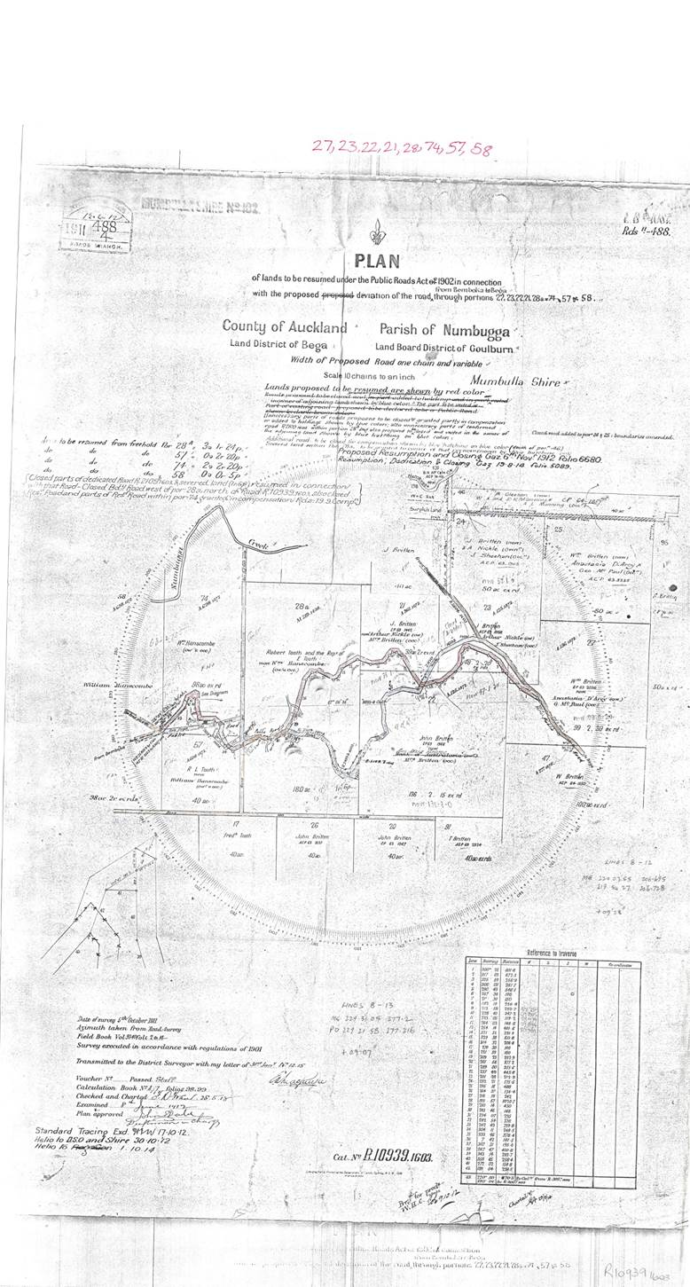
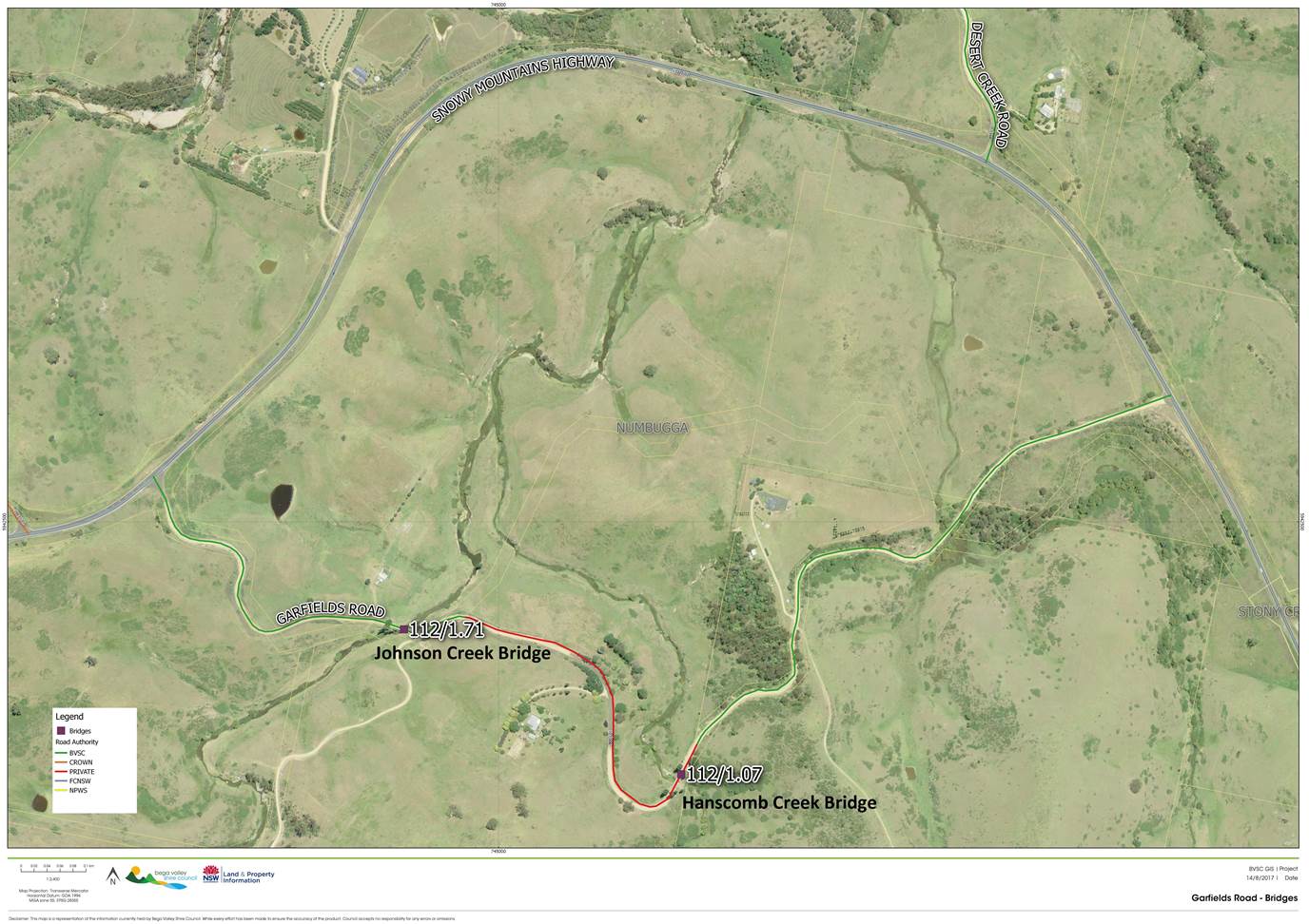
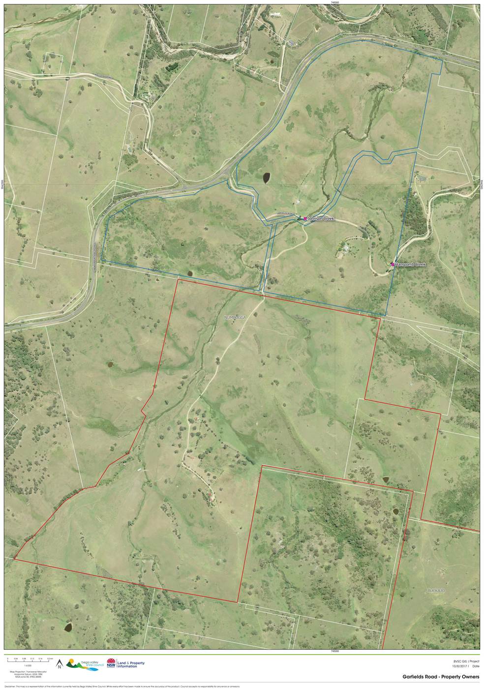
12.6 Scheduled Maintenance of Hanscomb Creek Bridge and Johnson Creek Bridge, Garfields Road, Numbugga..................................................................................................................................................... 181
13.1 Appointment of Delegates to attend Conferences 2017/18 and Councillor development program 2018..................................................................................................................................................... 181
13.2 Asset review - setting the framework for 2018/19 and into the refocus of the long term financial plan..................................................................................................................................................... 181
Nil Reports
There were no reports to Standing Committees
18.1 Affordable Housing in the Bega Valley..................................................................................... 181
18.2 Submission to the Joint Regional Planning Panel regarding Proposed recreational flight school at Lot 1 DP 109606; 1070 Princes Highway, Frogs Hollow.................................................................... 181
19.1 Cr Fitzpatrick - Question regarding Water Security and Biodiversity in Rural Areas........ 181
19.2 Cr Bain Question on Notice - Wanatta Lane Satellite station................................................ 181
Representations by members of the public regarding closure of part of meeting
Adjournment Into Closed Session, exclusion of the media and public......................... 181
21.1 Review of Corporate Business Systems
This report is confidential in accordance with section 10A (2) (c) (d) of the Local Government act 1993 as the report contains information that would, if disclosed, confer a commercial advantage on a person with whom the Council is conducting (or proposes to conduct) business; AND the report contains commercial information of a confidential nature that would, if disclosed (i) prejudice the commercial position of the person who supplied it; or (ii) confer a commercial advantage on a competitor of the Council; or (iii) reveal a trade secret.
Council |
13 December 2017 |
9.1 Planning Proposal for Wolumla Deferred Matters............................................. 10
9.2 Proposed application to re-establish Alcohol Free Zone Merimbula central business district 121
9.3 Proposed establishment - Alcohol Free Zone Bega Commercial Centre......... 123
9.4 Planning Proposal Mapping of Environmental Zones....................................... 126
9.5 Planning Proposal Rural Residential Land South Pambula............................... 181
9.6 Section 82A review of determination - Lot 28 DP 1107525 K B Timms Drive, Eden - 5 lot subdivision......................................................................................................... 181
|
Council 13 December 2017 |
Item 9.1 |
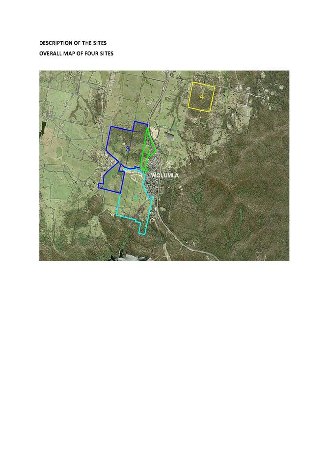
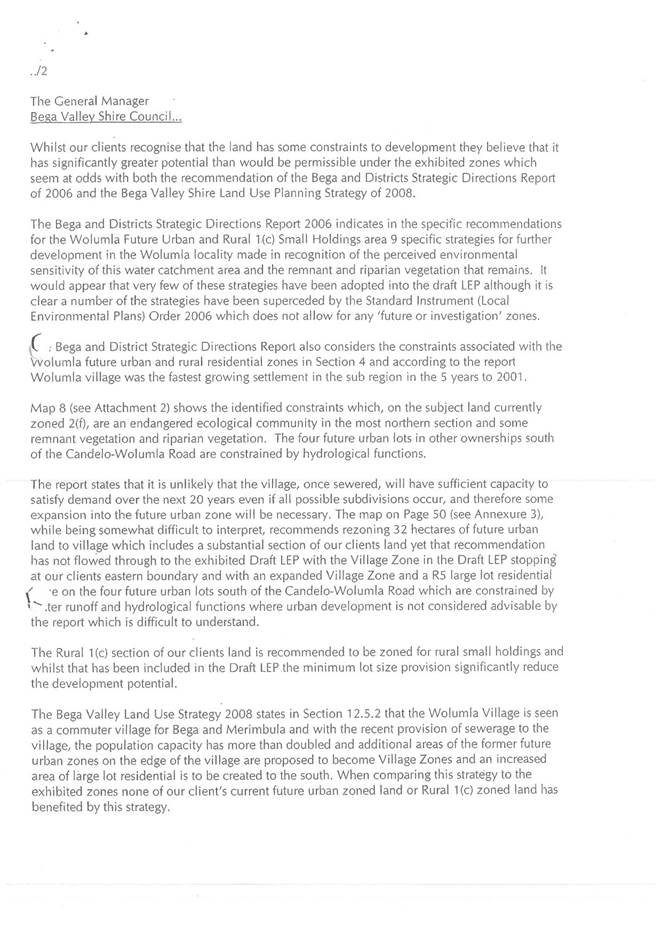
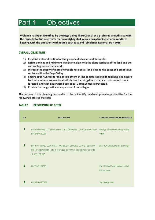
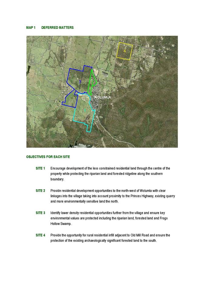
9.1. Planning Proposal for Wolumla Deferred Matters
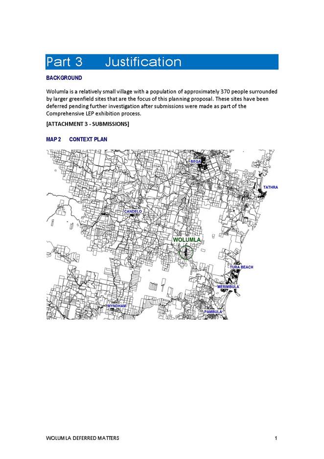
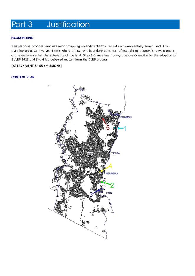
This report seeks Council’s resolution to submit a planning proposal for four sites around Wolumla that are currently Deferred Matters under Bega Valley Local Environmental Plan 2013.
Acting Director Planning and Environment
Background
The gazettal of Bega Valley Local Environmental Plan (BVLEP 2013) left a number of sites throughout the Shire as ‘deferred matters’ which are still subject to the provisions of Bega Valley Local Environmental Plan 2012 (BVLEP 2012). This report builds upon the actions and investigations for each of these four sites as presented to Council on 20 July 2016 and discussed in a Councillor workshop. Council officers have prepared a Planning Proposal that incorporates the four deferred sites around Wolumla. This report provides a summary of the objectives and intended outcomes of the Planning Proposal.
Planning Proposal Objectives
· Establish a clear direction for the greenfield sites around Wolumla.
· Refine zonings and minimum lot sizes to align with the characteristics of the land and current legislative framework.
· Increase the supply of more affordable residential land close to the coast and other town centres within the Bega Valley.
· Ensure opportunities for the development of less constrained residential land and ensure key environmental attributes such as ridgelines, riparian corridors and more forested land with Endangered Ecological Communities are protected.
· Provide for the growth and expansion of our villages.
Description of the sites and recommendations
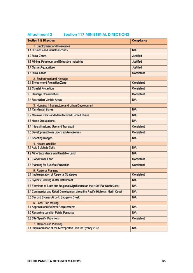
Details of the four sites are outlined in the table below including current zoning status. Attachment 1 to this report provides photographic details of each of the sites.
|
SITE |
PROPERTY |
ADDRESS |
CURRENT ZONE (BVLEP 2002) |
|
1 |
LOT 1 DP 947772, LOT 2 DP 1048404, LOT 12 DP 1176792, LOT 65 DP 664914 AND LOT 67 DP 750238 |
Ferndale Lane and Candelo-Wolumla Road, Wolumla |
Part 1(a) General Rural and 2(f) Future Urban |
|
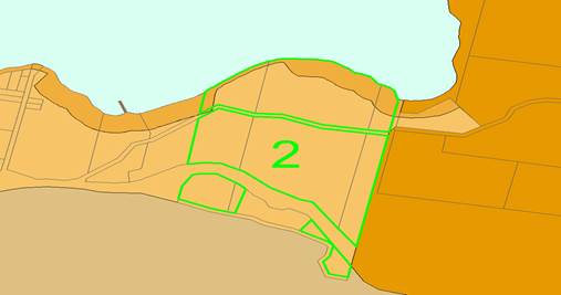
2 |
LOT 1 DP 1067459, LOTS 1-10 DP 1067458, LOT 2 DP 3833, LOTS 2-4 SEC 9 DP 997, LOT 6 DP 252442, LOTS 9-13 DP 3833, LOTS 11-24 SEC 8 DP 997, LOTS 16-17 SEC 1 DP 997 |
Princes Highway, Wolumla |
2(f) Future Urban Zone and 2(v) Village |
|
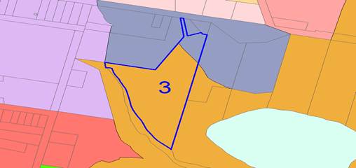
3 |
LOT 6 DP 1132826 |
210 Candelo-Wolumla Road, Wolumla |
Part 1(c) Rural Small Holdings and 2(f) Future Urban |
|
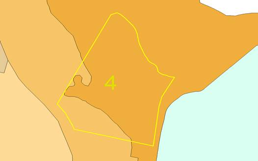
4 |
LOT 171 DP 750238 |
102 Old Mill Road, Wolumla |
1(a) General Rural |
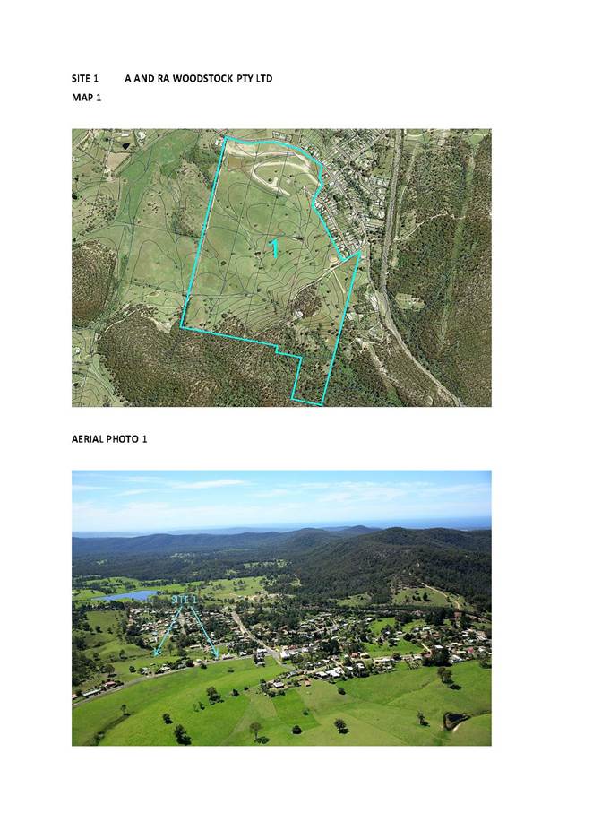
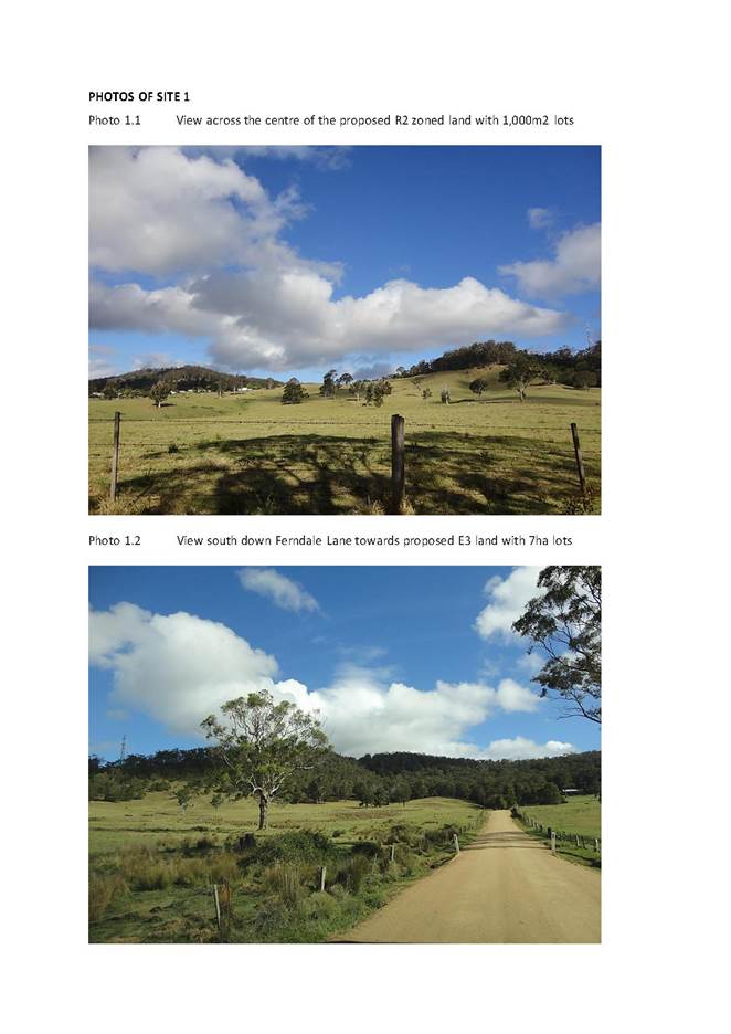
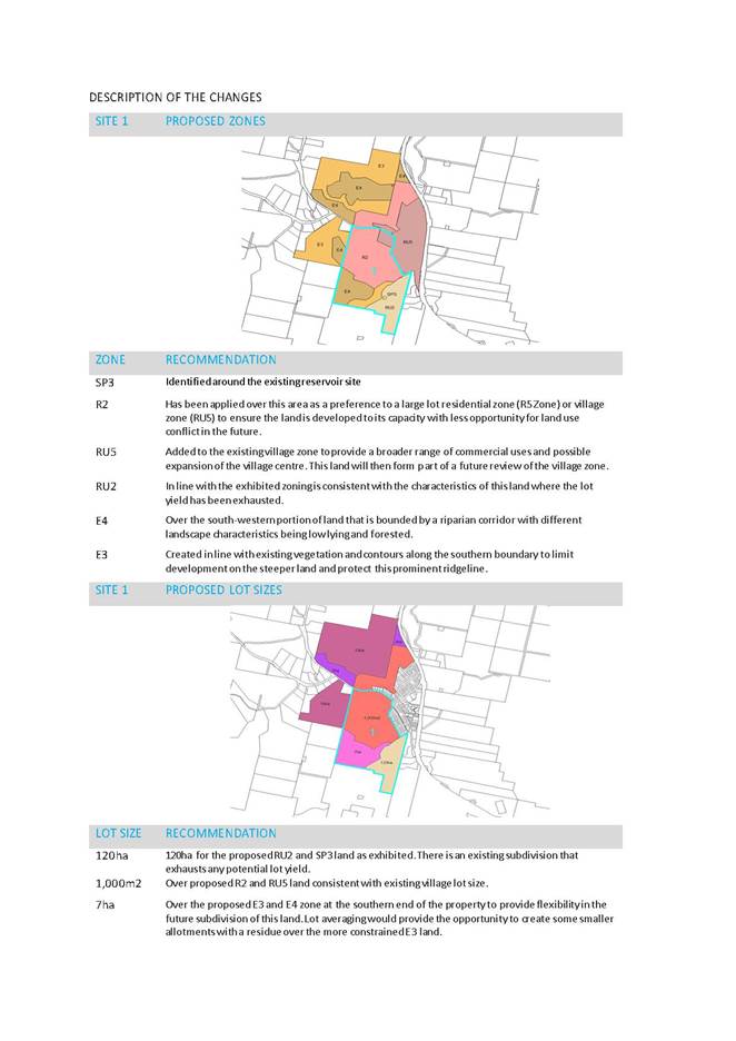
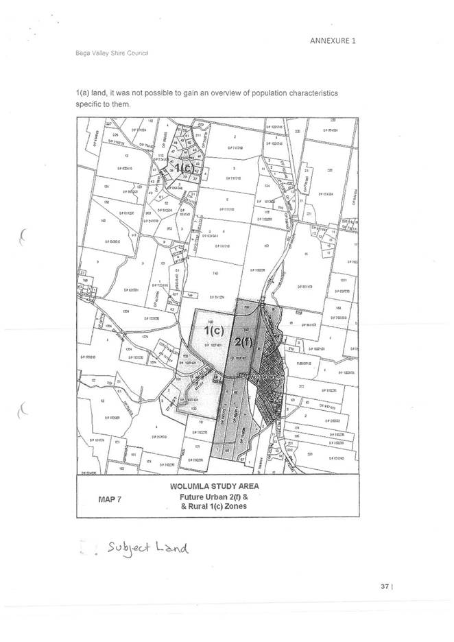
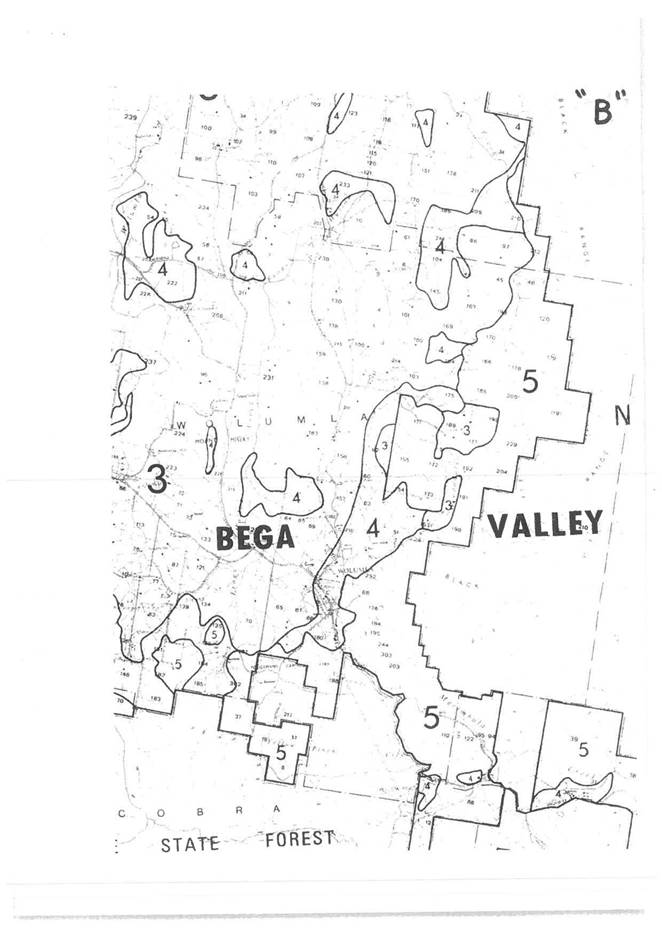
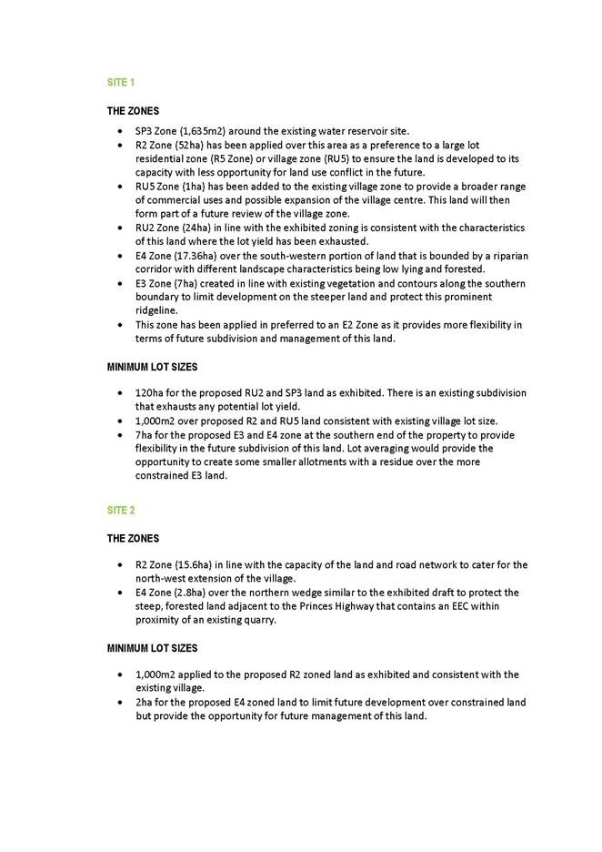
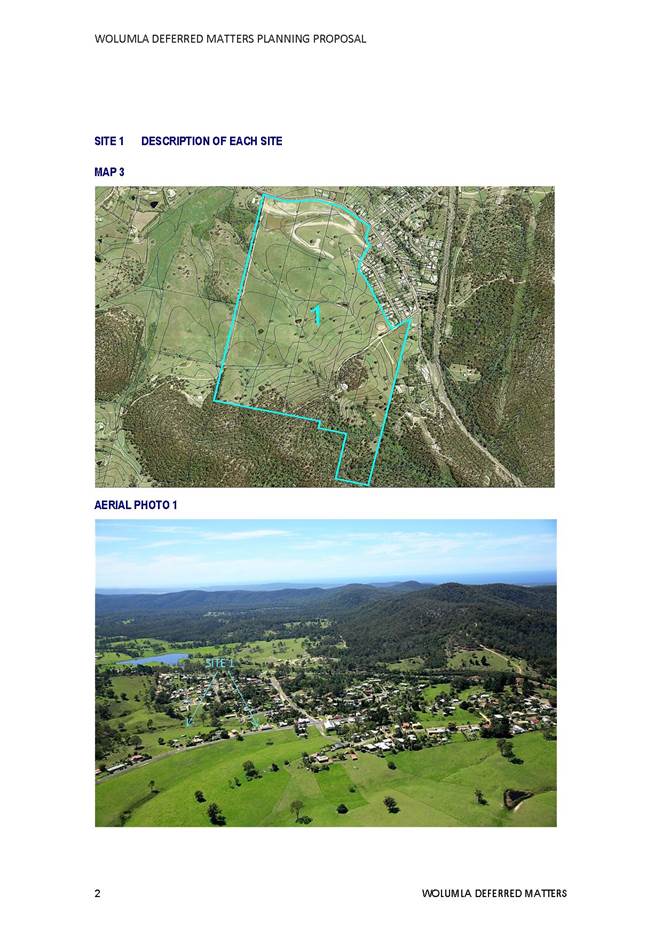
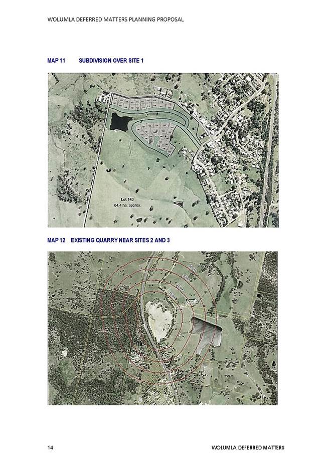
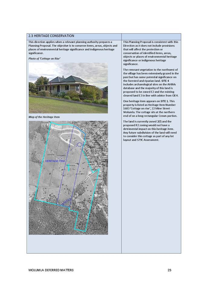
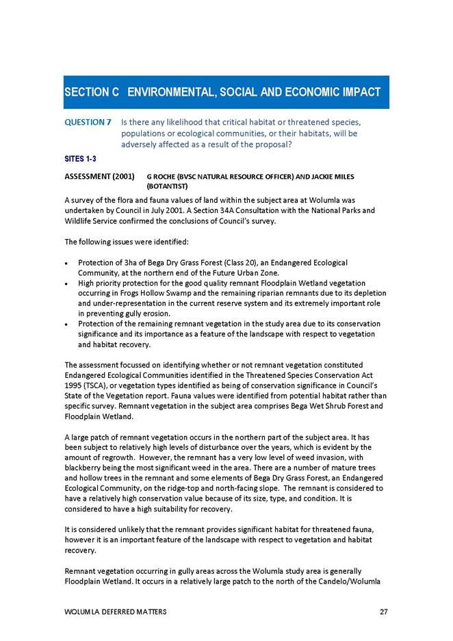
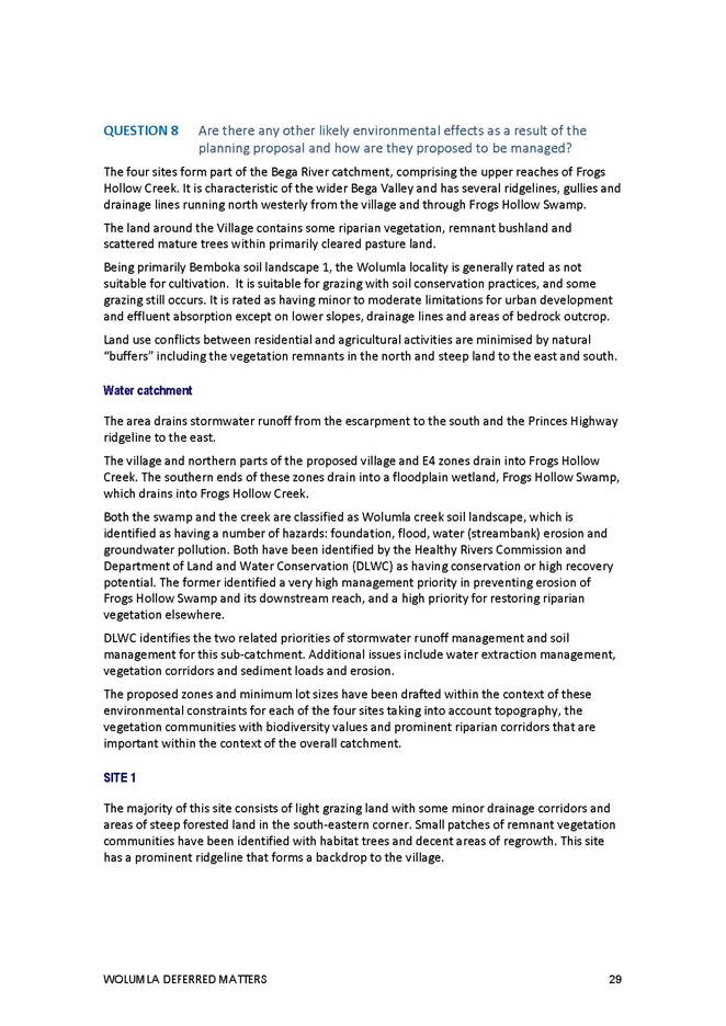
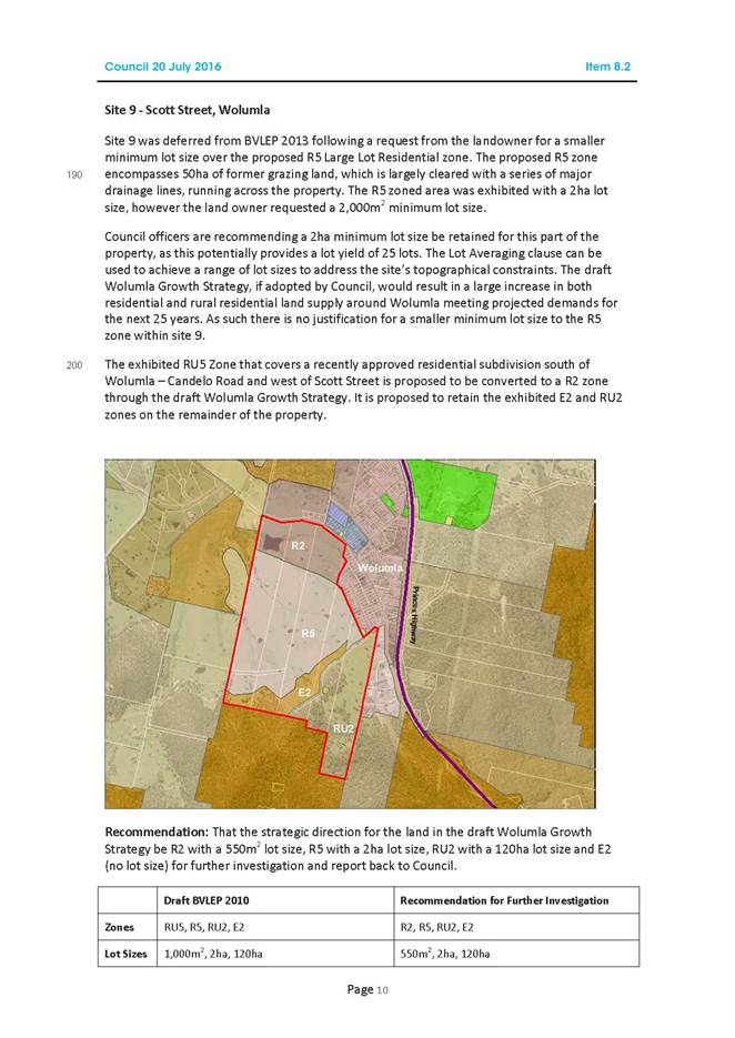
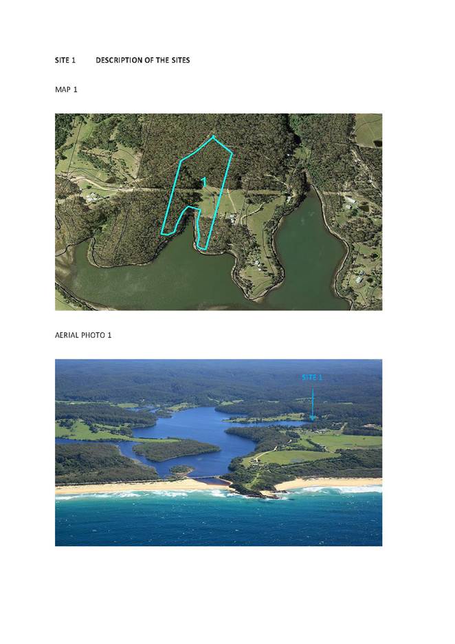
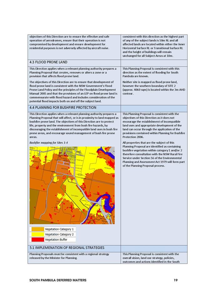
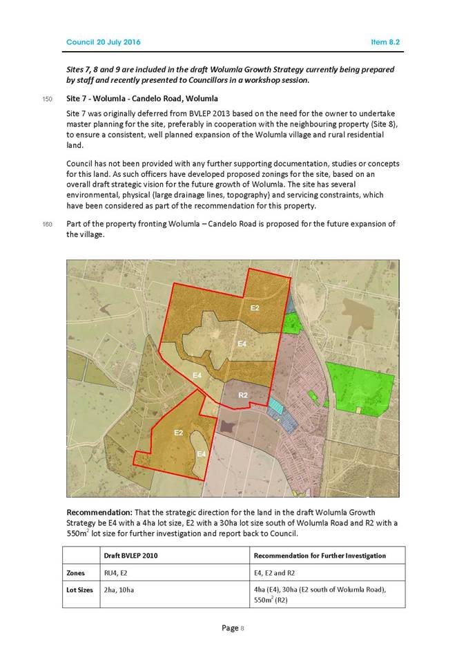
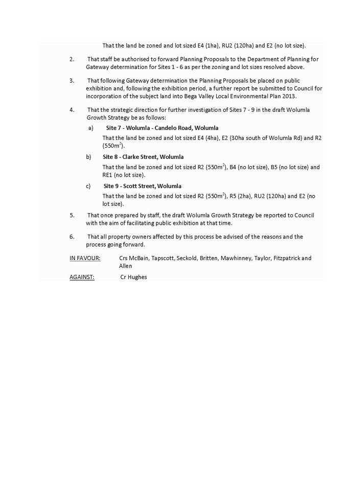
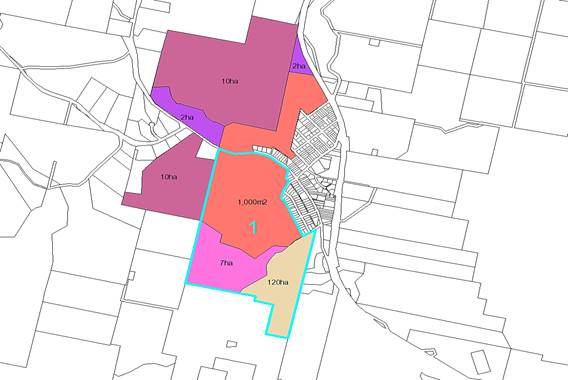
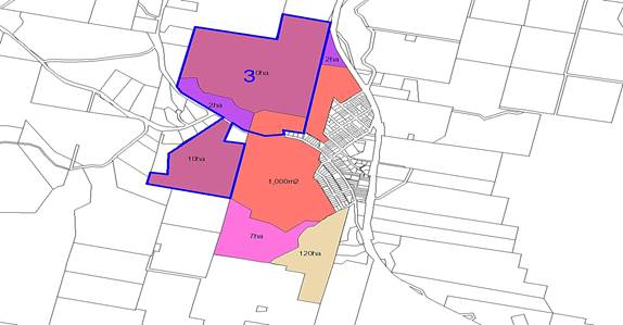
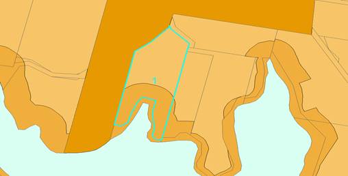
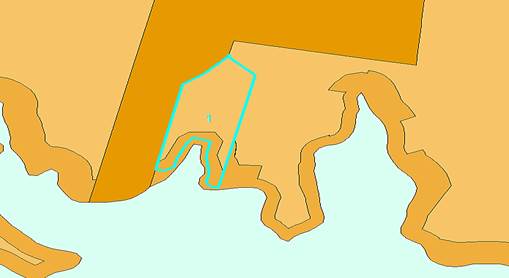
Site 1 Ferndale lane and Candelo-Wolumla Road, Wolumla
Objective
· Encourage development of the less constrained land while protecting the riparian land and forested ridgeline along the southern boundary.
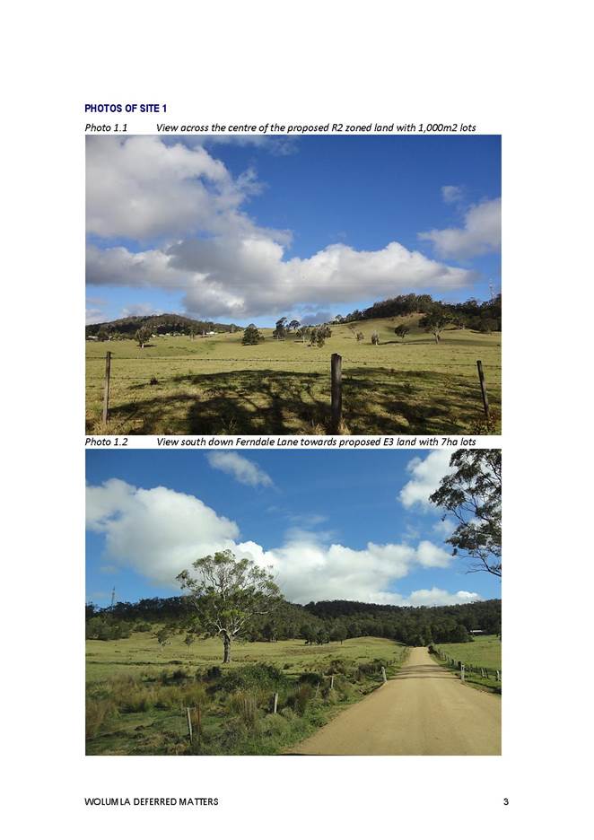
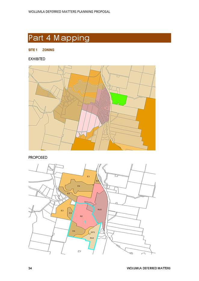
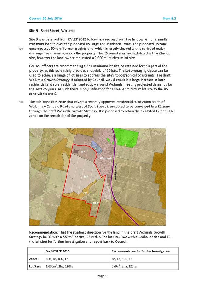
This is a large property on the southern side of the Candelo-Wolumla Road covering an area of 97ha. The land consists of cleared pasture land with some riparian corridors and a forested ridgeline running along the southern boundary. There is an existing approval for 42 new residential allotments (2007.759) where roadworks have already commenced. The majority of this land has development potential and is relatively unconstrained.
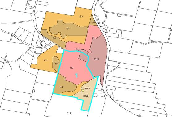
It is recommended the zoning of this property be amended from R5 (Large Lot Residential) as exhibited and presented (Site 9 in Council Report on 20 July 2016) to R2 (Low Density Residential) Zone with a small section of RU5 (Village). It is considered the recommended zoning would encourage development on the less constrained land and provide an opportunity for an expansion of the village centre. Environmental zones have been recommended for the steeper and more forested land towards the south of the property with a special use zone over the existing reservoir. An E3 Zone has been recommended to facilitate the future use and management of this land.
Whilst the Council Resolution of 20 July 2016 referred to a 550m 2 minimum lot size, Council officers consider that a 1000m 2 lot size would be more appropriate to maintain the Village atmosphere and would be consistent with the approved subdivision layout. A 7ha minimum lot size is recommended for the environmental zones to facilitate lot averaging and the creation of larger lots over the more constrained land.
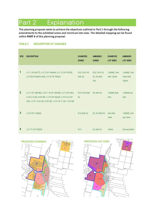
Proposed Amendments
|
SITE |
PROPERTY |
EXHIBITED |
PROPOSED |
EXHIBITED |
PROPOSED |
|
1 |
Ferndale Lane and Candelo-Wolumla Road, Wolumla |
RU2 RU5 and E2 |
RU2 RU5 R2 E3 E4 AND SP2 |
1,000M2 2HA AND 120HA |
1,000M2 2HA 10HA AND 120HA |
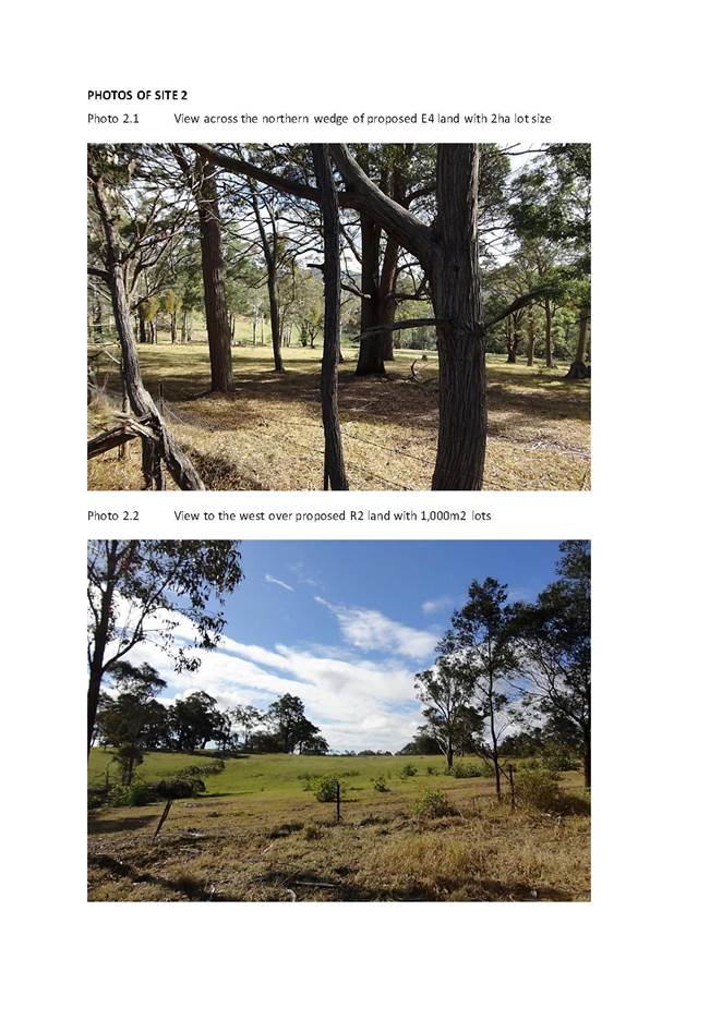
PROPOSED ZONES
PROPOSED LOT SIZES
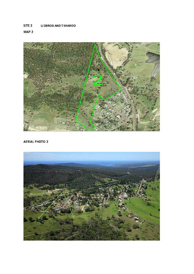
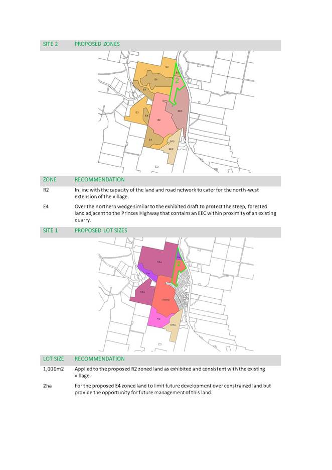
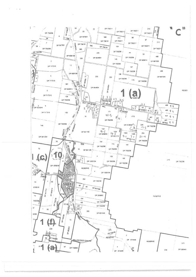
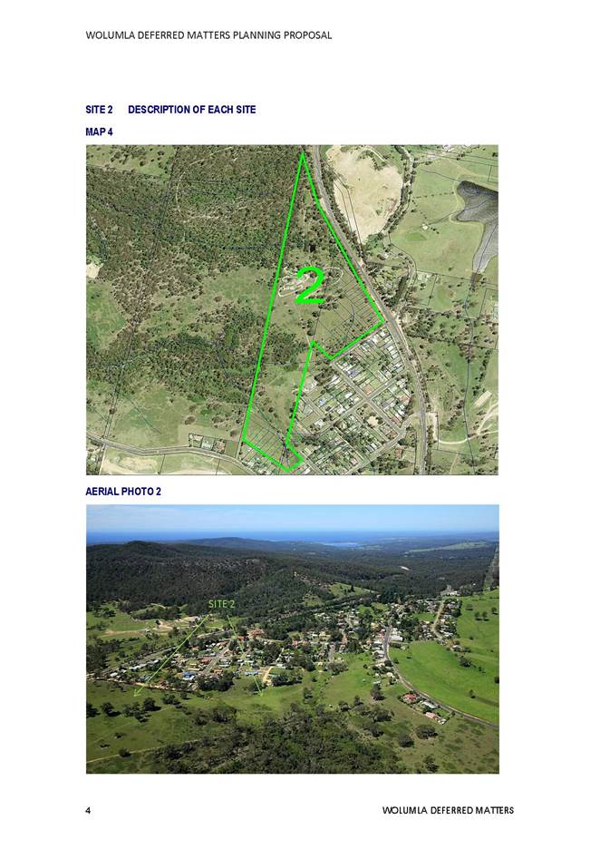
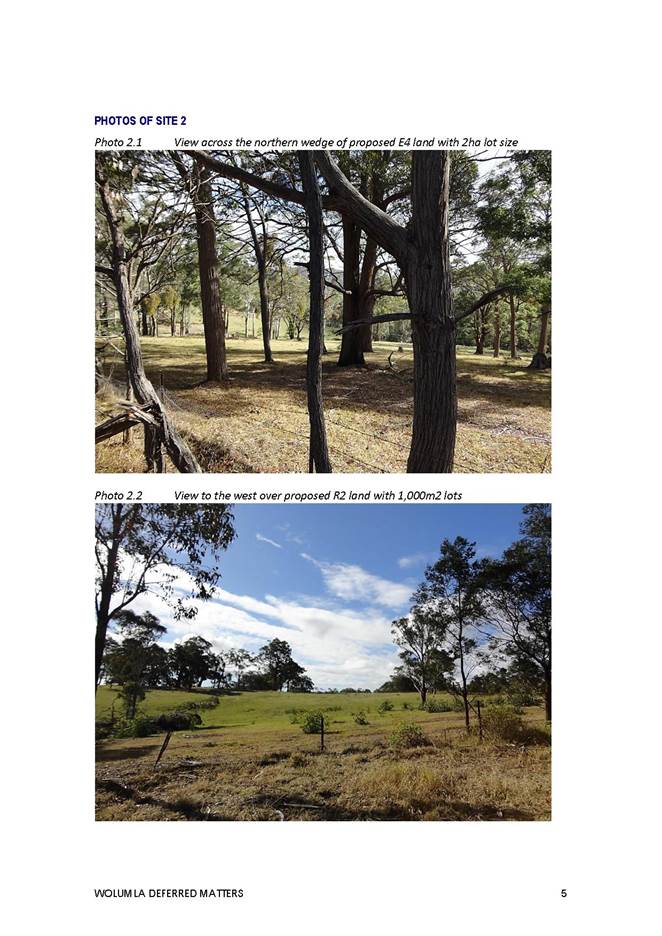
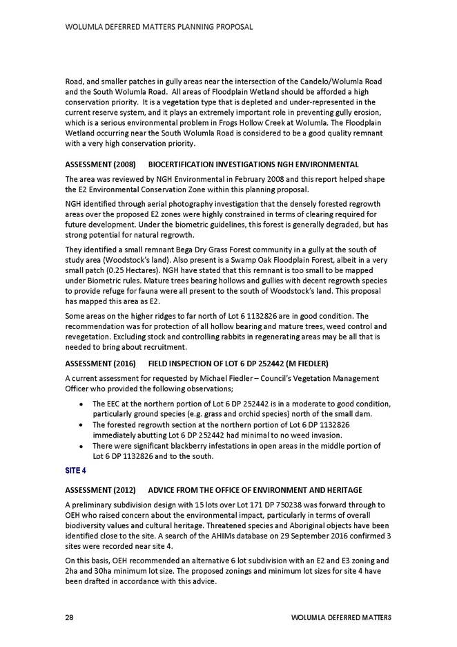
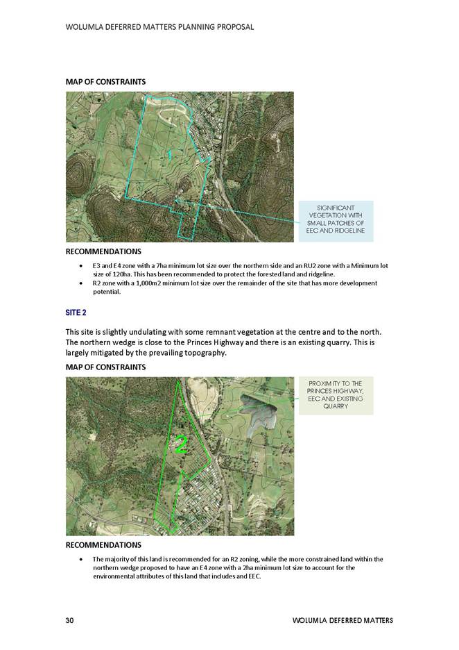
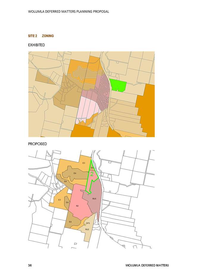
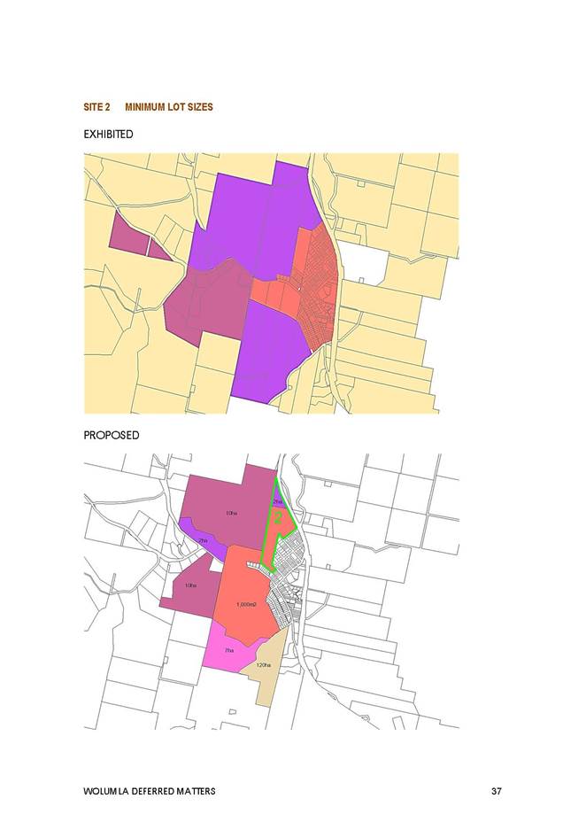
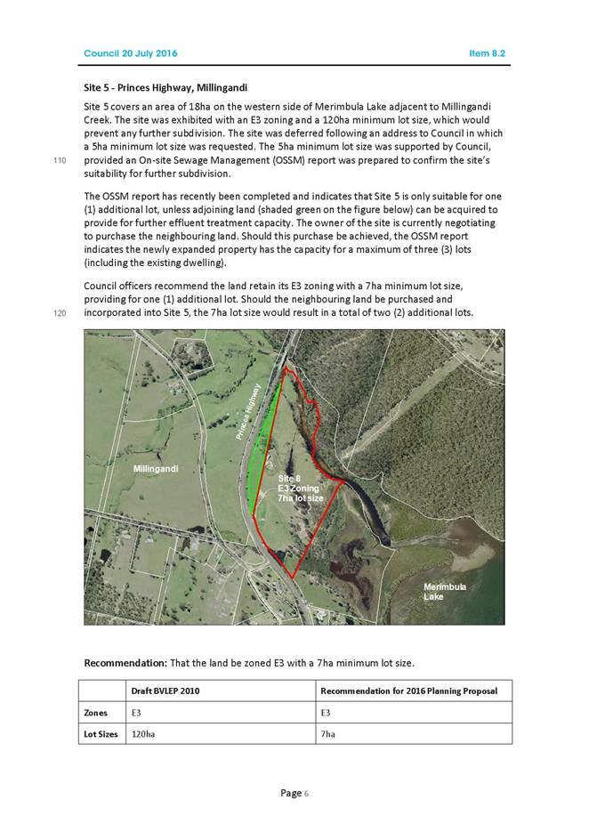
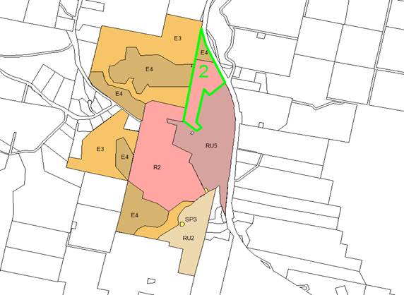
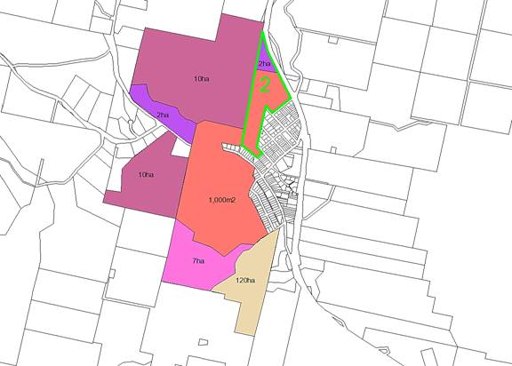
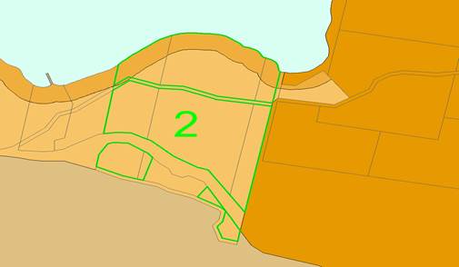
Site 2 Princes Highway, Wolumla
Objective
· The provision of residential development opportunities to the north-west of Wolumla with clear linkages into the village taking into account proximity to the Princes Highway, existing quarry and more environmentally sensitive land to the north.
This property is a smaller portion of land on the western edge of the village. The site covers an area of 12.88ha. The majority of the land is cleared with some large remnant trees and an Endangered Ecological Community at the northern end.
An R2 (Low Density Residential) Zone is recommended to encourage more residential land use and reduce the potential for land use conflict.
This residential zoning will link with the proposed R2 Zoning recommended within Sites 1 and 3. An E4 Environmental Living Zone is recommended over the more constrained land to the north.
The previous mixed use zone (Site 8 in Council Report on 20 July 2016) has been removed as the owners no longer wish to proceed with a highway service centre.
A lot size of 1,000m2 is recommended over the proposed R2 portion to link with the existing village lot size and Sites 1 and 3 with a 2ha lot size over the proposed environmental zone as originally exhibited.
Proposed Amendments
|
SITE |
PROPERTY |
EXHIBITED |
PROPOSED |
EXHIBITED |
PROPOSED |
|
2 |
Princes Highway, Wolumla |
RU4 RU5 AND E2 |
R2 AND E4 |
1,000M2 AND 2HA |
1,000M2 AND 2HA |
PROPOSED ZONES
PROPOSED LOT SIZES
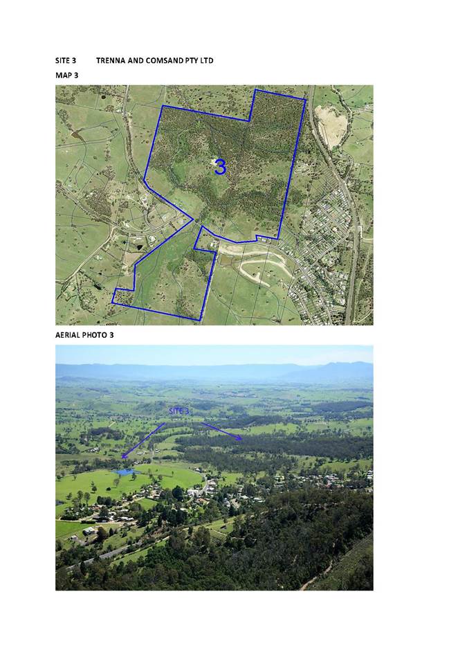
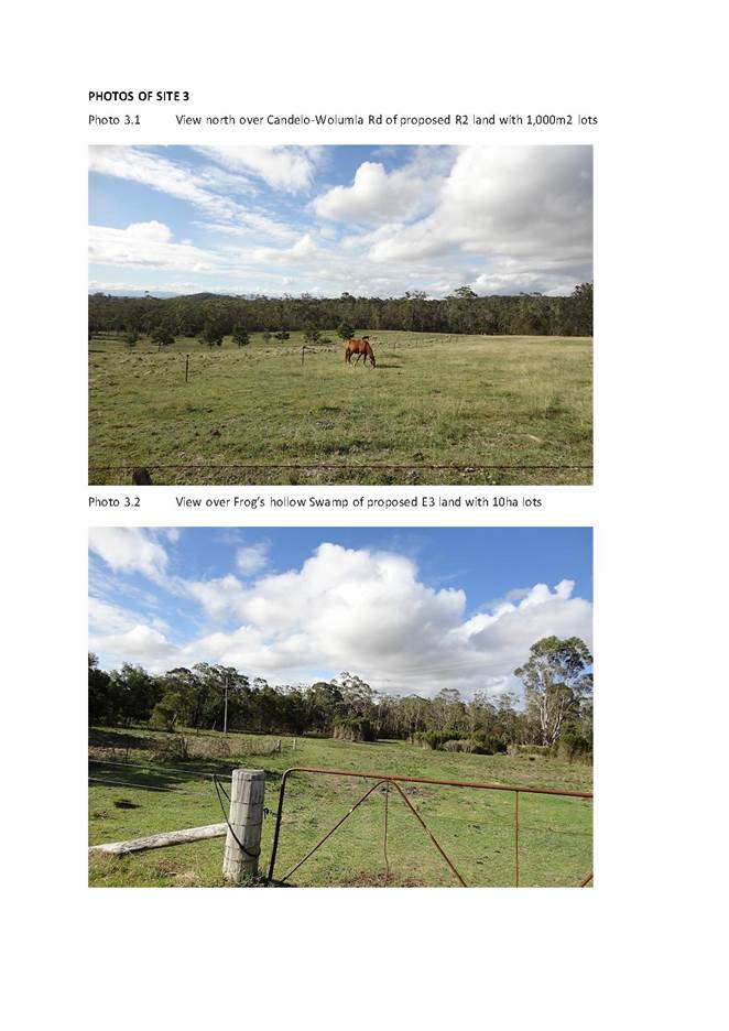
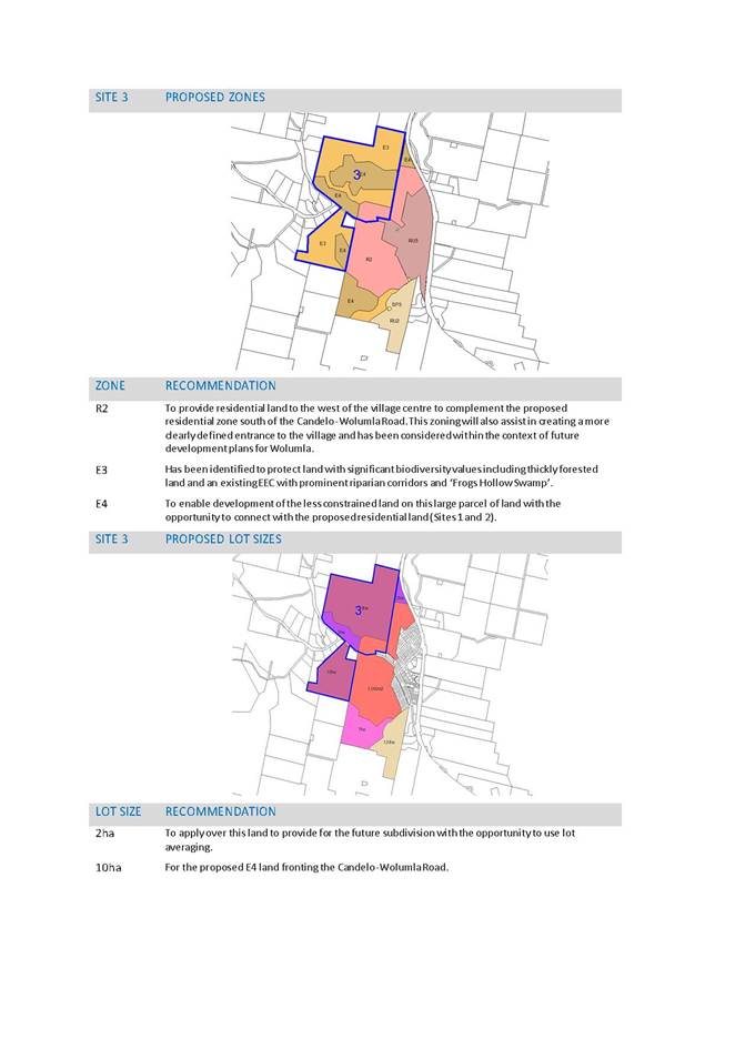
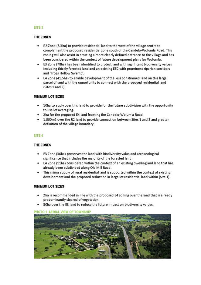
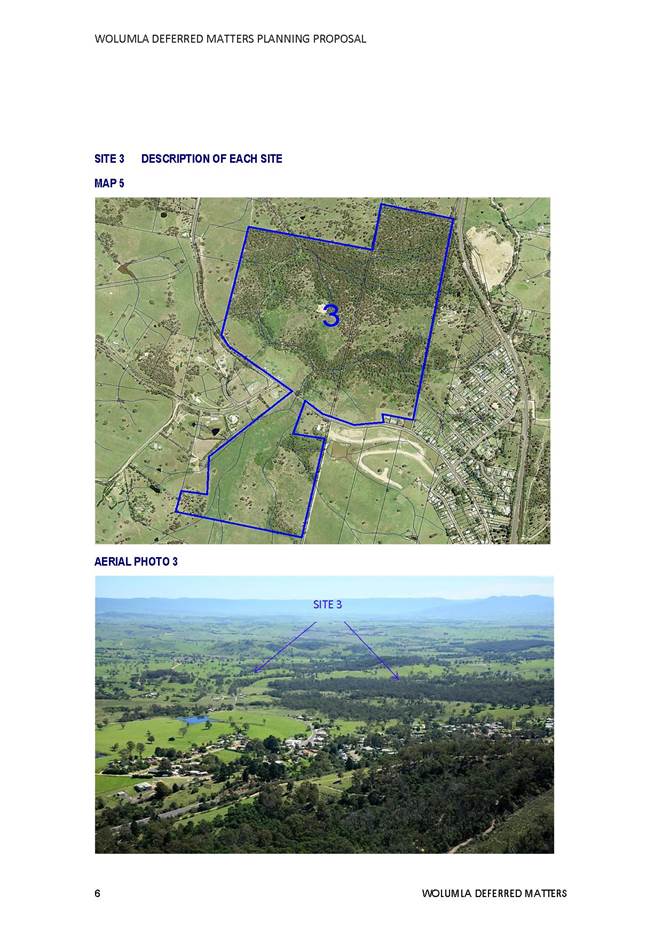
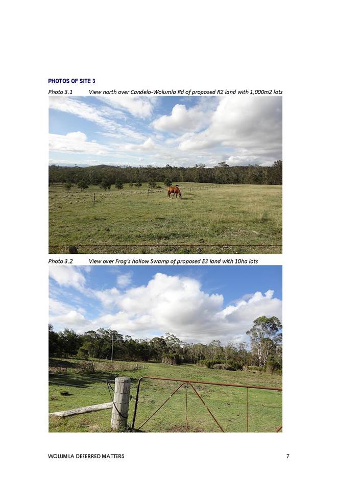
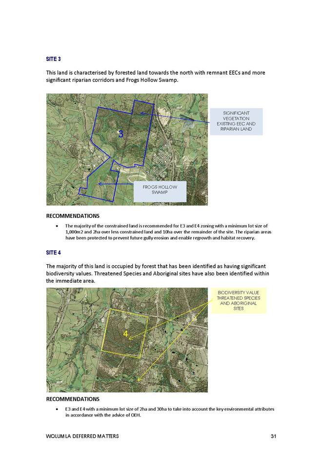
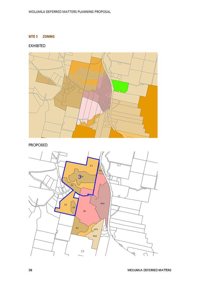
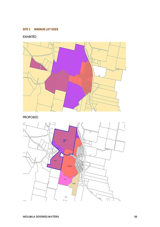
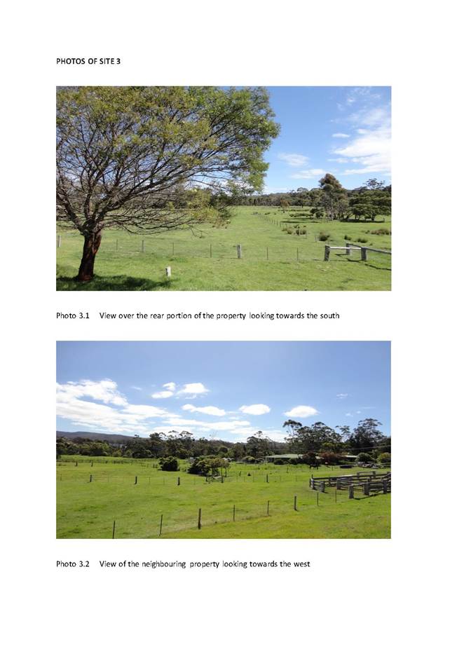
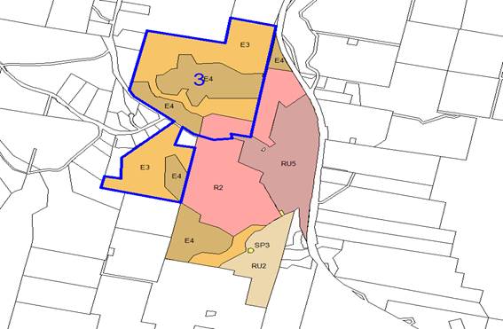
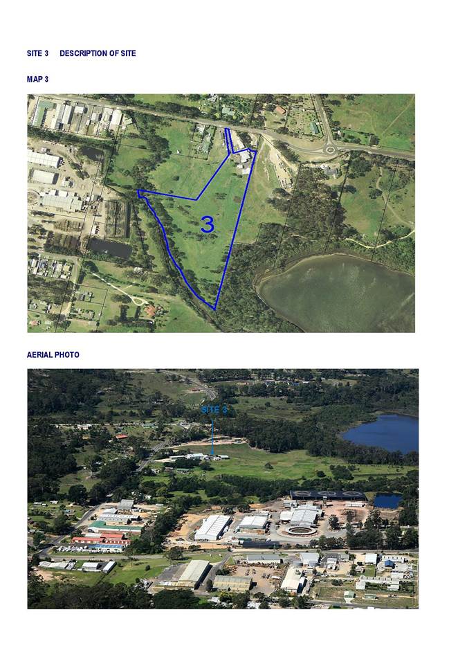
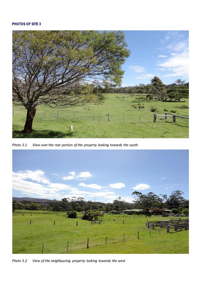
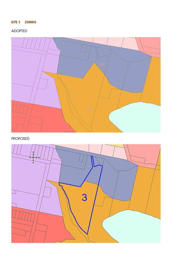
Site 3 210 Candelo-Wolumla Road, Wolumla
Objective
· Identify lower density residential opportunities further from the village and ensure key environmental values are protected including the riparian land, forested land and Frogs Hollow Swamp.
This is the largest of the four sites covering an area of 127.9ha that extends around the western perimeter of Wolumla. The site is divided by the Candelo-Wolumla Road with densely forested land to the north and Frogs Hollow Swamp to the south. This site is also constrained by Endangered Ecological Communities with some pockets of more developable land.
An R2 (Low Density Residential) Zone is recommended over the cleared and less constrained land to the north of the Candelo-Wolumla Road to connect with the proposed R2 Zone within Site 1 and to provide greater definition to the village boundary. A purely residential zone has been selected, rather than an RU5 Village Zone to ensure there is less potential for industrial type land uses along this main road entrance into Wolumla. An E3 Zone has been used for the more heavily forested section of the property, in place of the E2 Zoning that was previously presented (Site 7 in Council Report on 20 July 2016) as it will provide more flexibility for future lot layouts on this section of the property.
1,000m2 is recommended over the residential portion to connect with Sites 1 and 2. It will allow more flexibility than a 550m2 with the consideration of future residential development such as dual occupancies and connect with the existing village zone. After further investigation, the split lot sizing of 4ha and 30ha would also restrict future subdivision of the property. 10ha lot size is therefore recommended over the E3 Environmental Management Zone and E4 Environmental Living Zone to provide the opportunity for lot averaging.
Proposed Amendments
|
SITE |
PROPERTY |
EXHIBITED |
PROPOSED |
EXHIBITED |
PROPOSED |
|
3 |
210 Candelo-Wolumla Road, Wolumla |
RU4 and E2 |
R2, E3 AND E4 |
2HA AND 10HA |
1,000M2 2HA AND 10HA |
PROPOSED ZONES
PROPOSED LOT SIZES
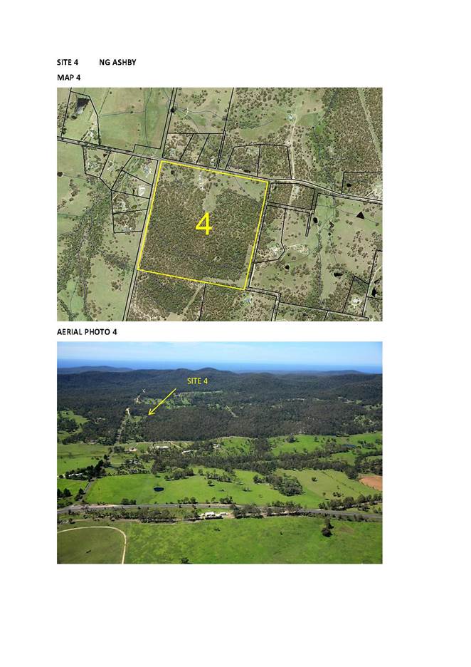
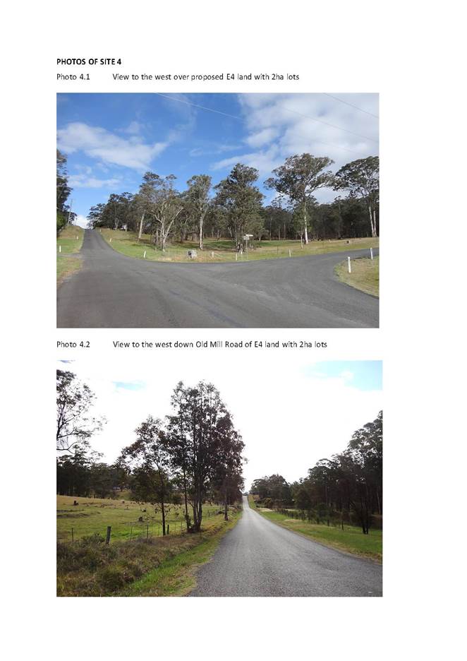
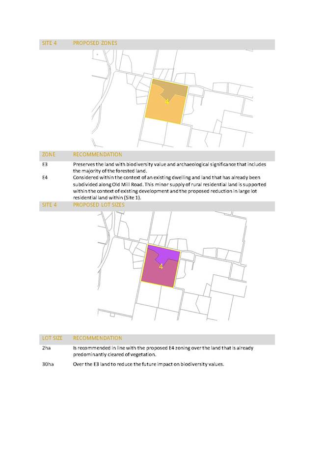
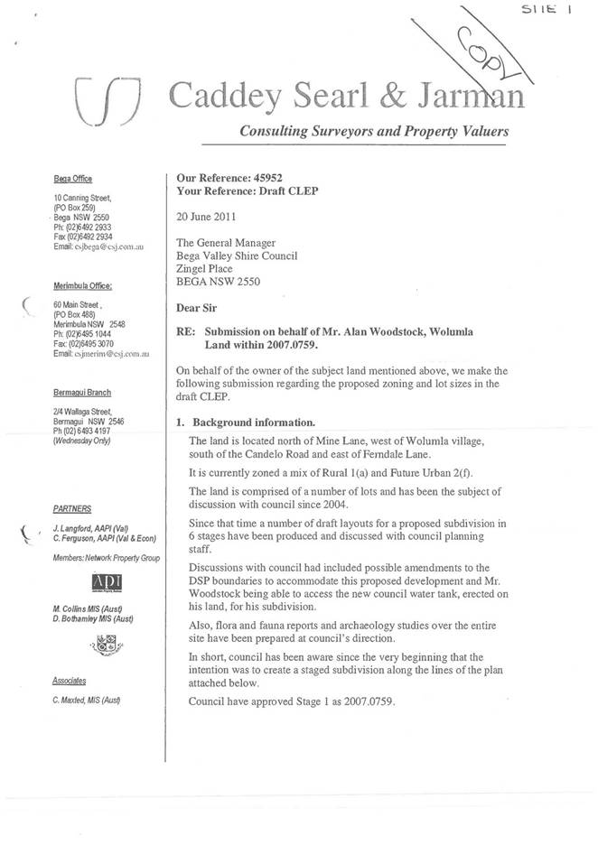
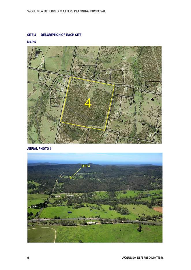
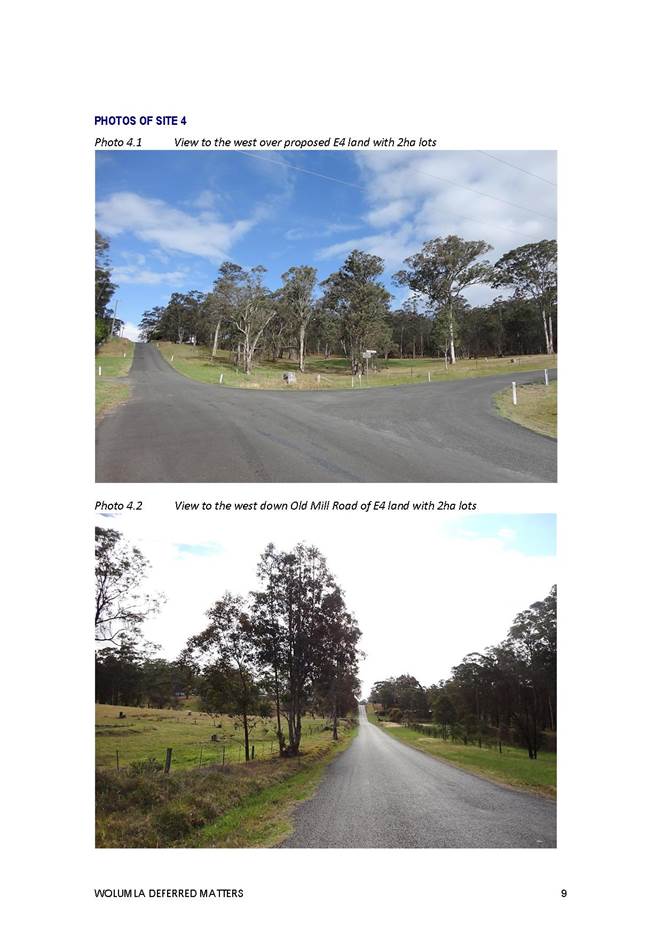
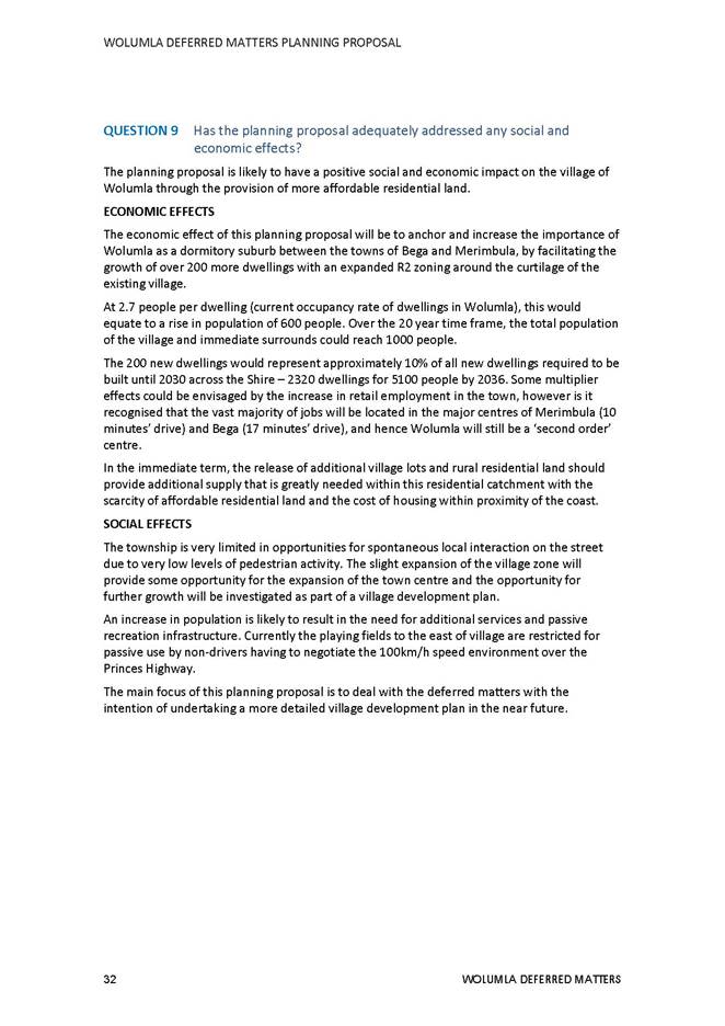
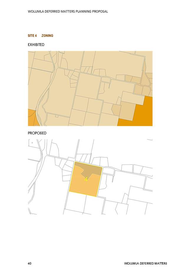
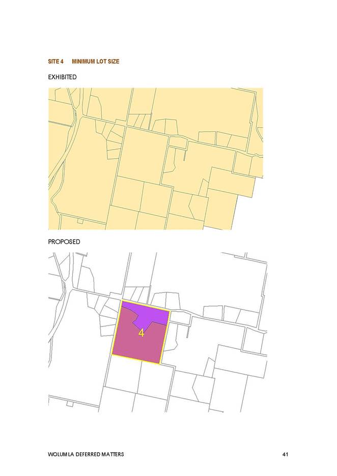
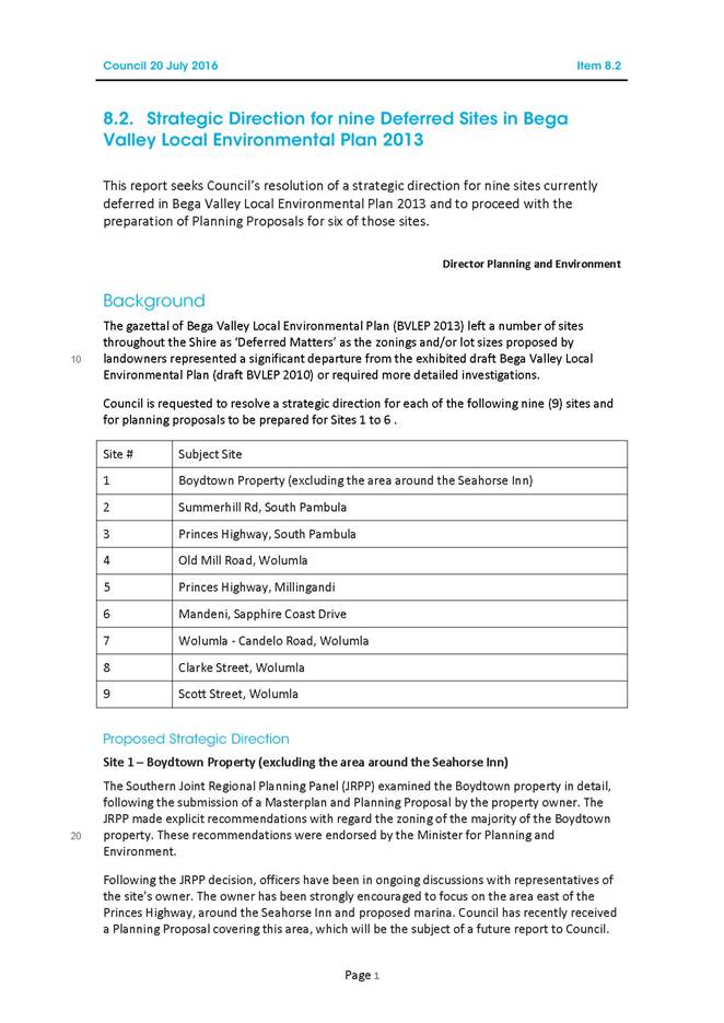
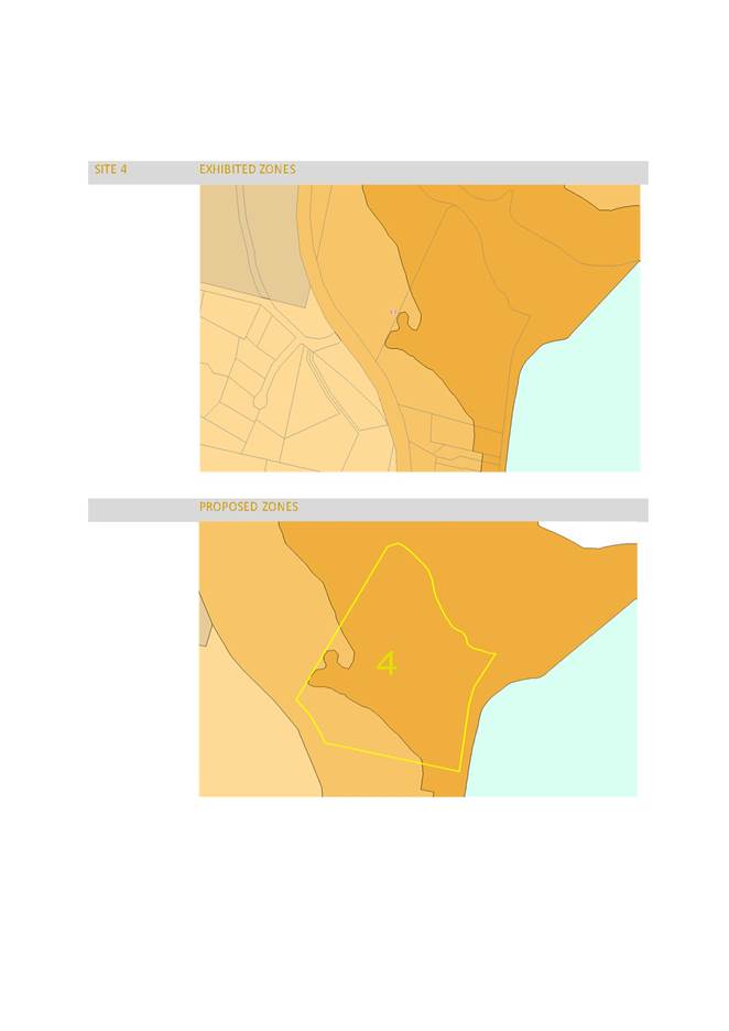
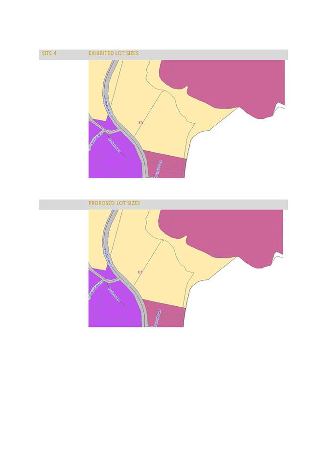
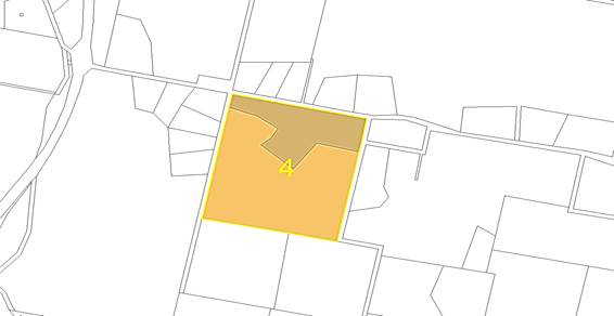
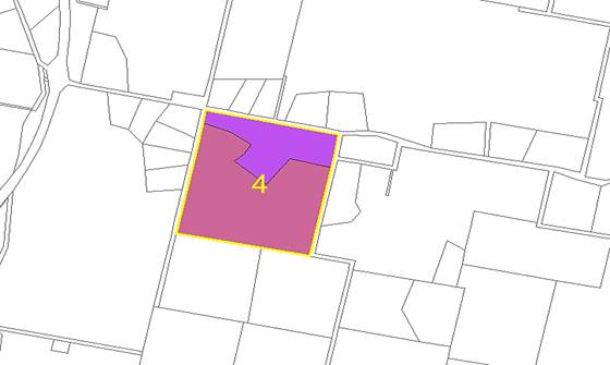
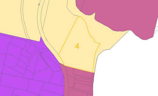
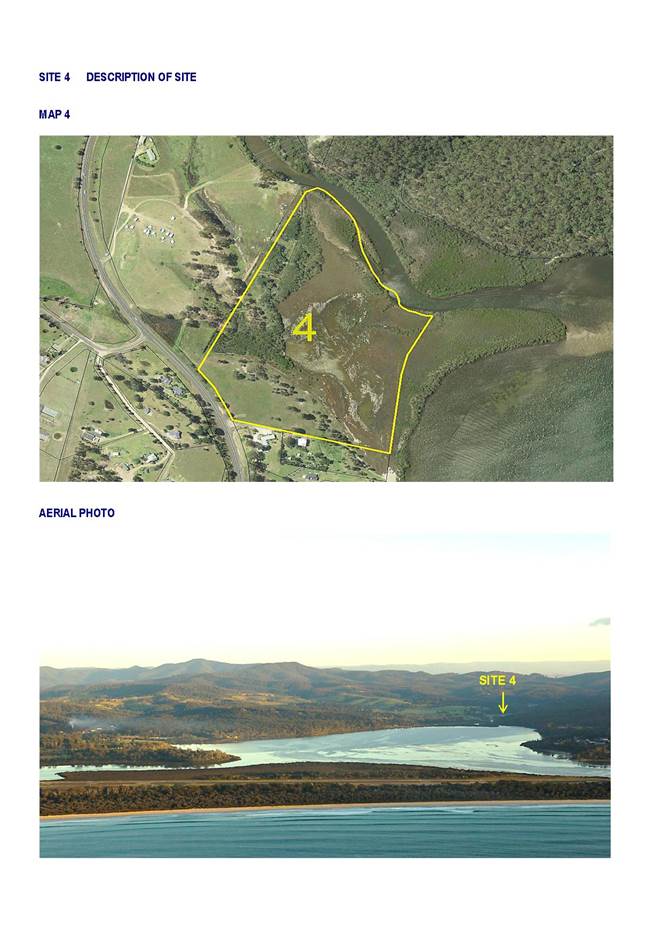
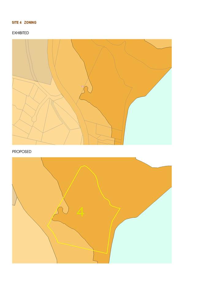
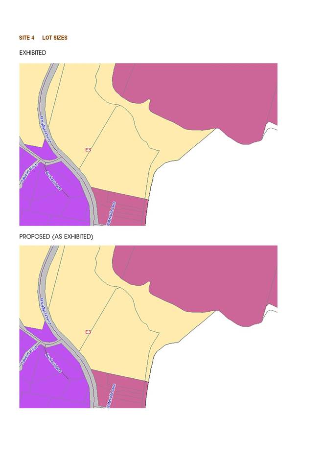
Site 4 102 Old Mill Road, Wolumla
Objective
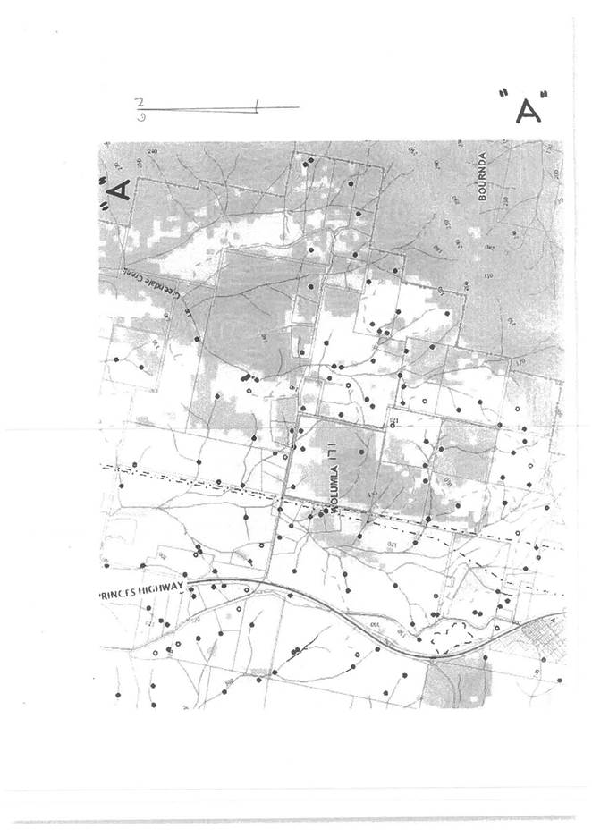
· Provide the opportunity for rural residential infill adjacent to Old Mill Road and ensure the protection of the existing archaeologically significant forested land to the south.
This site is divided into two distinct landscapes. The land to the north, next to Old Mill Road is predominantly cleared and free of environmental constraints, while the land to the south is more forested with archaeological significance. A split zoning of E4 Environmental Living Zone over the clear land and E3 Environmental Management Zone over the more constrained forested land, with a split lot size of 2ha and 30ha over these zones is recommended as presented to Council previously (Site 4 in Council Report on 20 July 2016).
Proposed Amendments
|
SITE |
PROPERTY |
EXHIBITED |
PROPOSED |
EXHIBITED |
PROPOSED |
|
4 |
102 Old Mill Road, Wolumla |
RU1 |
E3 and E4 |
120HA |
2HA AND 30HA |
PROPOSED ZONES
PROPOSED LOT SIZES
Development Outcomes
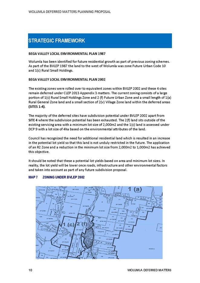
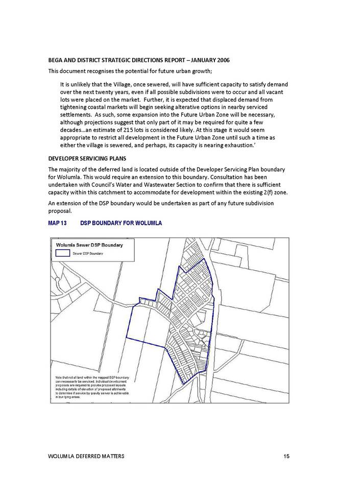
The majority of the deferred sites have subdivision potential under BVLEP 2012 apart from Site 4 where the subdivision potential has been exhausted. The 2(f) land sits outside of the existing servicing area with a minimum lot size of 2,000m2 and the 1(c) land is assessed under DCP 9 with a lot size of 4ha based on the environmental attributes of the land.
All four sites have been reviewed within the context of the overall objectives for Wolumla and those that apply to each of the four sites. In this context, the need for additional residential land has been recognised by increasing the overall lot yield of the less constrained land and reducing in the minimum lot sizes were possible. This has been undertaken in accordance with the advice of Council's Water and Wastewater Section.
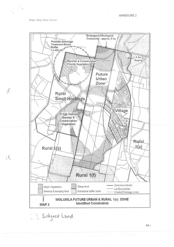
Environmental zones have been recommended with larger lot sizes over the more constrained land to protect these key environmental attributes including a swamp, thick forested land, riparian corridors, prominent ridgelines and existing Endangered Ecological Communities.
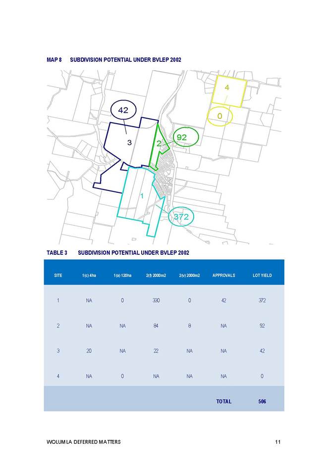
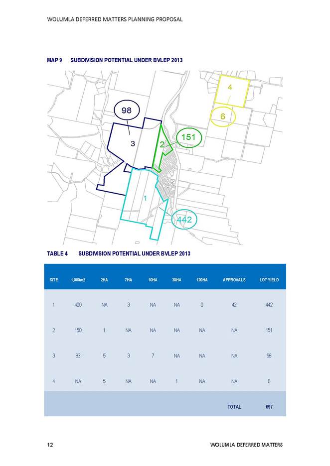
This planning proposal results in a hypothetical additional lot yield for each one of the four sites as detailed in the table below;
|
SITE |
OWNER |
EXISTING LOT YIELD (BVLEP 2002) |
Hypothetical LOT YIELD (BVLEP 2013) |
|
1 |
Ferndale Lane and Candelo-Wolumla Road, Wolumla |
372 |
442 |
|
2 |
Princes Highway, Wolumla |
92 |
151 |
|
3 |
210 Candelo-Wolumla Road, Wolumla |
42 |
98 |
|
4 |
102 Old Mill Road, Wolumla |
0 |
6 |
|
TOTAL |
506 |
697 |
|
Consultation
If endorsed by Council, the Wolumla Planning Proposal will be placed on public exhibition following Gateway Determination from the Department of Planning and Environment.
Conclusion
The purpose of this Planning Proposal is to resolve the Wolumla deferred matters in accordance with the objectives and recommendations outlined in this report and to provide a clear way forward.
The deferred matters are being considered within the context of the existing legislative framework and recently adopted South East and Tablelands Regional Plan 2036. The resolution of these larger sites will provide a direction for the growth of Wolumla and enable Council officers to commence work on more detailed place based plans to cater for the future social and infrastructure needs this additional residential growth will create.
The Bega Valley Shire is experiencing an ever increasing demand for affordable housing and it is considered our villages play an important strategic role in the provision of residential land within an increasingly constrained coastal catchment.
This planning proposal has been prepared with clear objectives for both zoning and lot sizes that encourage the development of the best available residential land, while protecting the key environmental attributes of these four sites.
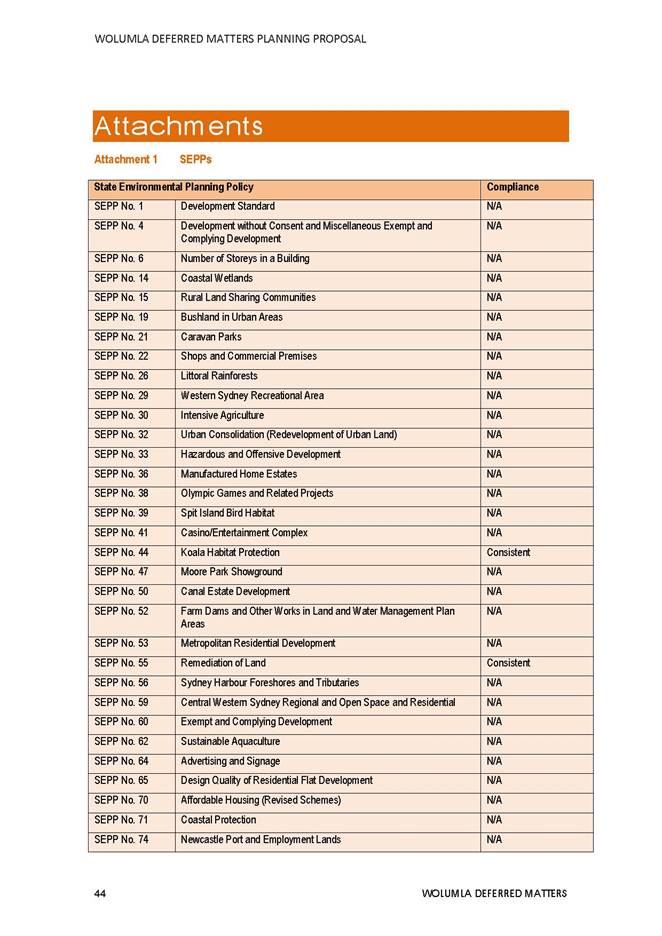
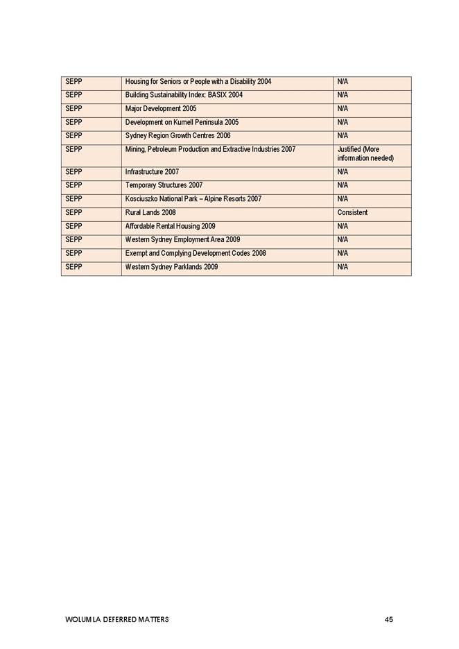
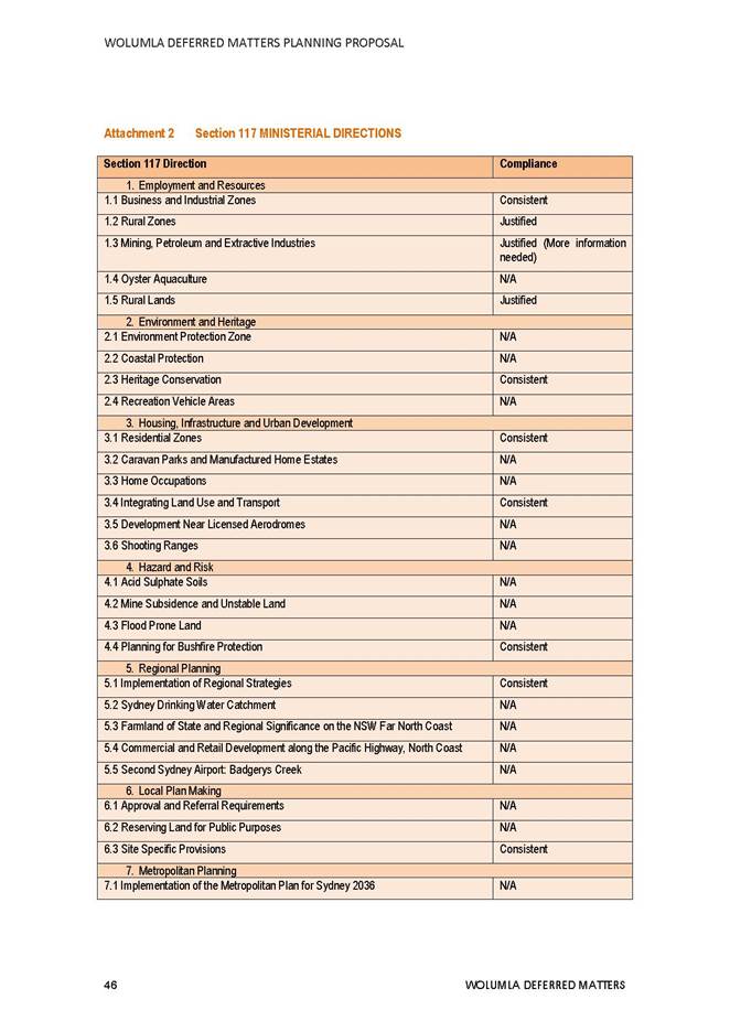
Attachments
1⇩. Descriptions of the Sites
2⇩. Mapping of the Changes
3⇩. Submissions
4⇩. Draft Wolumla Planning Proposal
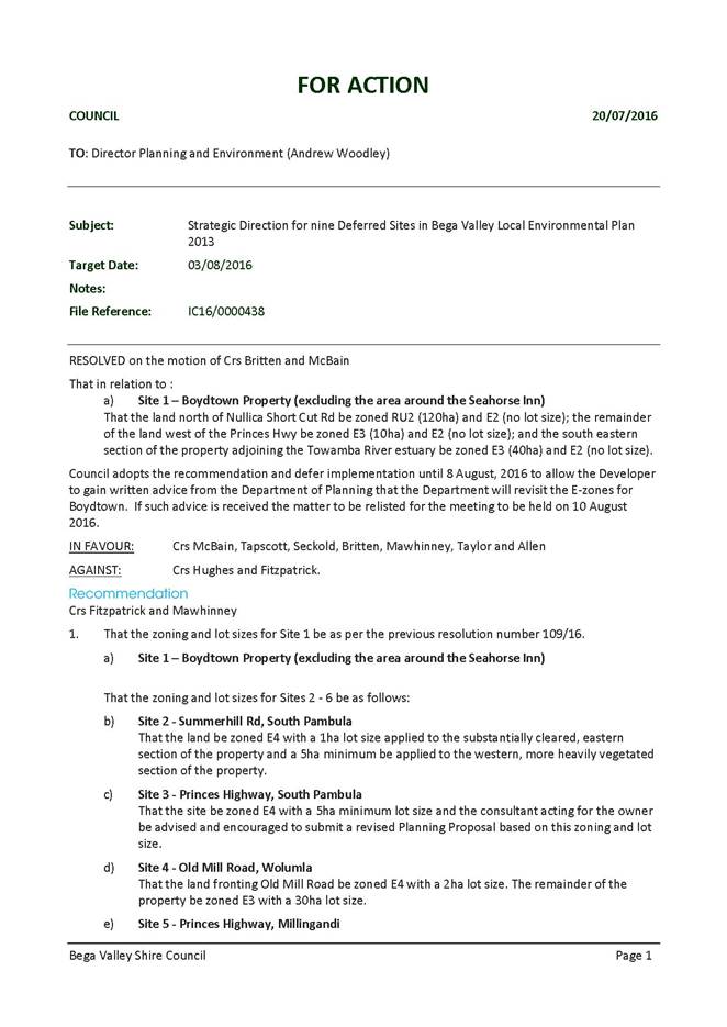
5⇩. Council Action Report 20 July 2016
6⇩. Council Report 20 July 2016
|
1. That Council resolve to adopt the zoning and lot sizing for Sites 1-4 as identified in Attachment 2 to this report. 2. That Council officers be authorised to forward this Planning Proposal for Wolumla Deferred Matters to the Department of Planning for Gateway Determination in accordance with the zonings and lot sizes recommended within this report. 3. That following Gateway Determination the Planning Proposal is placed on public exhibition and, following the exhibition period, a further report be submitted to Council for incorporation of these four sites within the Bega Valley Local Environmental Plan 2013. 4. That Council officers commence work on a place based development plans for the villages that will link in with this Planning Proposal to provide a coordinated approach to the future development of Wolumla. |
|
Item 9.2 |
Acting Director Planning and Environment
On 21 November 2012 Council resolved to establish an alcohol free zone (AFZ) in Market Street Merimbula for a period of four (4) years. That application was made by Merimbula Police and expired on 21 November 2016. NSW Police have made application to re-establish an alcohol free zone for a further four (4) period.
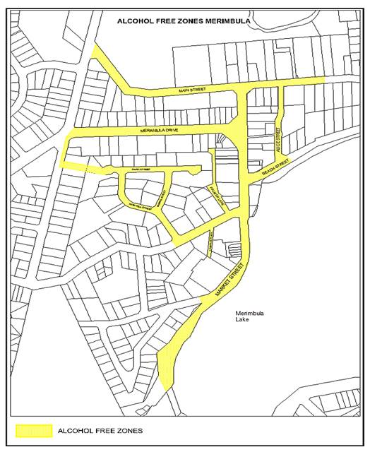
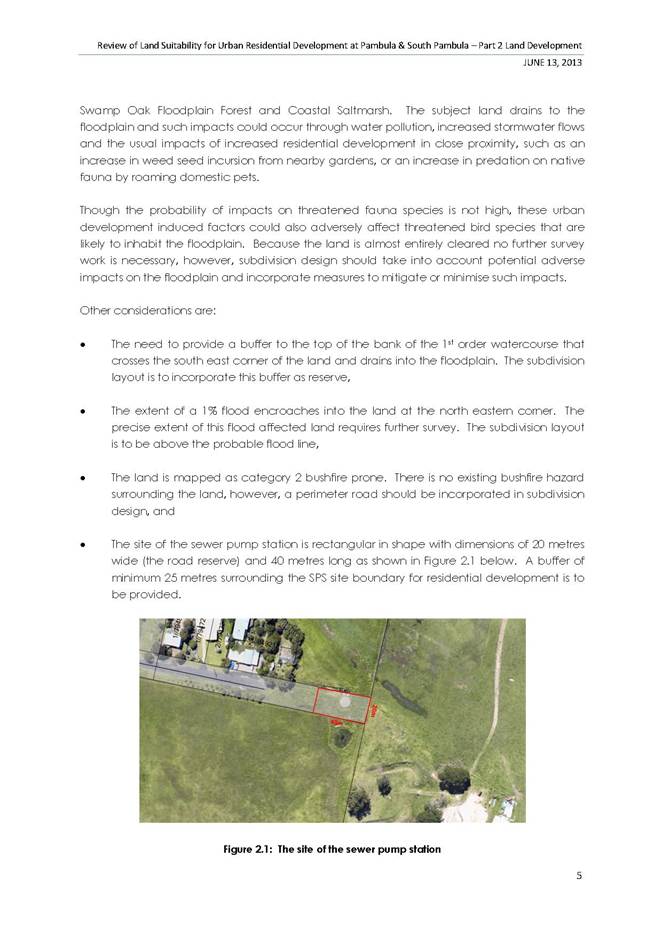
Figure 1
NSW Police advise that the Merimbula Central Business District (CBD) and surrounds continue to be areas subject to alcohol related crimes such as Malicious Damage and assaults on persons. The proposed AFZ would provide additional powers to assist Police in reducing alcohol related unsociable behaviour and bolster public safety and awareness. In the previous years when the AFZ was in place there was a positive impact on Policing operations which led to a steady decline in alcohol related crime.
If resolved by Council, the AFZ would be made in accordance with s.644B Local Government Act 1993 and the Ministerial Guidelines on AFC.
In accordance with the provisions of the Ministerial Guidelines Council is required to undertake public consultation for a period of 30 days by placing a notice in a newspaper circulating in the area the proposed AFZ is to apply inviting inspection of the proposal and comments.
The proposal is for the re-establishment of an AFZ for a further four (4) years.
Signage designating the Merimbula CBD to be an AFZ is currently in place, and apart from a date change, would be a neutral cost to Council. There is no implication for public land use by licenced premises within the area.
Council would only need to consider the auditing of current signage and changing the dates on signs currently erected around the Merimbula CBD.
|
Funding source |
|
Amount |
|
From existing allocation. |
$ |
200 |
Nil
|
Council 13 December 2017 |
Item 9.3 |
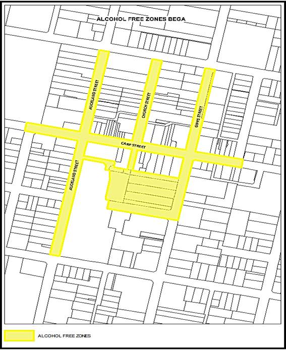
Bega Police and Bega Valley Shire Liquor Accord have applied to Council to establish an Alcohol Free Zone within the Bega Central Business District.
Acting Director Planning and Environment
Bega Police and the Bega Valley Shire Liquor Accord have formally requested Council establish an Alcohol Free Zone (AFZ) within the Bega Central Business District (CBD) pursuant to S.644 of the Local Government Act 1993 and the Ministerial guidelines on AFZs.
Police have advised Council that they continue to experience problems relating to the consumption of alcohol in public places in Bega. A meeting on 29 May 2017 with Police and the Bega Valley Shire Liquor Accord unanimously supported the establishment of an AFZ in the Bega CBD. Members at the meeting raised concerns of anti-social behaviour, damage to property and assaults on persons which related to the consumption and influence of alcohol in public places. This activity is uncontrolled and unmonitored as opposed to activity occurring on licenced premises or during organised events. Apart from Police patrolling the local area, alcohol consumption in public places is not monitored and typically occurs near licenced liquor premises and Littleton Gardens.
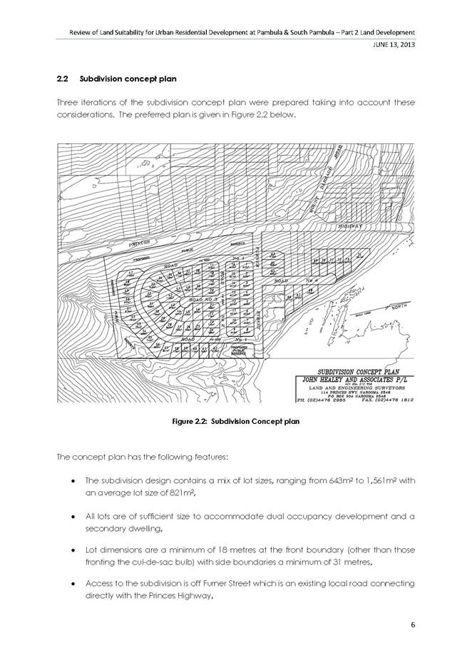
The proposed APZ is described as - Carp Street, between Peden Street, to the West and Canning Street to the East; Gipps Street, between Bega Street and Zingel Place; Auckland Street, between Bega Street and Upper Street; and all of Church Street and Ayres Place. If adopted the AFZ would be for a four (4) year period.
The proposal would require the installation of signs at strategic locations around the boundaries of the AFZ area. There is no implication for public land use by licenced premises within the area.
(Figure 1 – Proposed Alcohol Free Zone)
In accordance with the provisions of the Ministerial Guidelines Council is required to undertake public consultation for a period of 30 days by placing a notice in a newspaper circulating in the area the AFZ is to apply inviting inspection of the proposal and comments.
The introduction of an AFZ would require the erection of approximately six (6) to eight (8) galvanised poles with aluminium signs affixed, at appropriate locations, at a cost of approximately $1000.00.
|
Funding source |
|
Amount |
|
From existing allocation. |
$ |
1000 |
Nil
|
Council 13 December 2017 |
Item 9.4 |
9.4. Planning Proposal Mapping of Environmental Zones
This report seeks Council’s endorsement of a Planning Proposal for five sites involving changes to proposed or existing Environmental Zones
Acting Director Planning and Environment
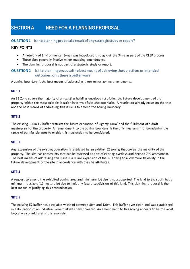
Background
This planning proposal relates to four requests for amendment to Bega Valley Local Environmental Plan 2013 (BVLEP 2013) and the resolution of a Deferred Matter under BVLEP 2013.
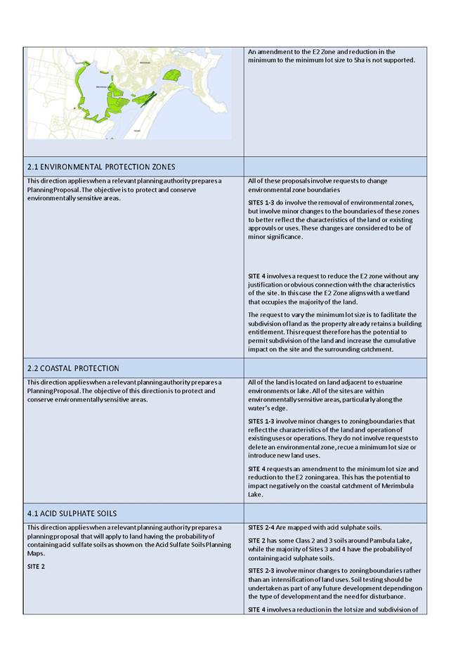
The retention of an environmental zoning is supported for sites 1-4, given they are all located within sensitive coastal catchments. However staff have reviewed the zones and it is considered that refinement of the zoning boundaries is justified. The recommended alterations to the zone boundaries are consistent with the methodology originally used as part of the original placement of the E2 Zones under BVLEP 2013.
The purpose of this report is to seek Council’s endorsement for the following five sites to be included in a Planning Proposal for lodgement with the Department of Planning.
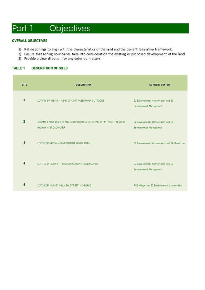
Objectives
· Refine zonings to align with the characteristics of the land and legislative framework.
· Ensure that zoning boundaries consider existing or proposed development of the land.
· Provide a clear direction for any deferred matters.
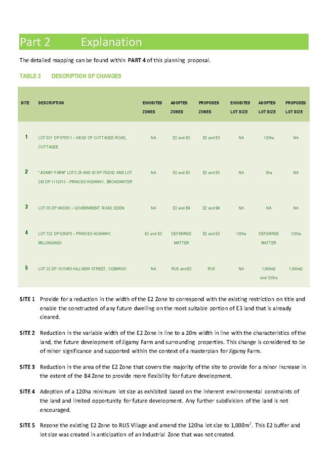
Description of the sites and recommendations
|
SITE |
PROPERTY |
ADDRESS |
CURRENT ZONE |
|
1 |
LOT 531 DP 875511 |
Head of Cuttagee Road, CUTTAGEE |
E2 Environmental Conservation and E3 Environmental Management |
|
2 |
LOTS 25 AND 43 DP 750242 AND LOT 243 DP 1112013 |
“Jigamy Farm” - Princes Highway, BROADWATER |
E2 Environmental Conservation and E3 Environmental Management |
|
3 |
LOT 35 DP 843393 |
Government Road, EDEN |
E2 Environmental Conservation and B4 Mixed Use |
|
4 |
LOT 722 DP 826975 |
Princes Highway, MILLINGANDI |
E2 Environmental Conservation and E3 Environmental Management |
|
5 |
Lot 22 DP 1013450 |
Hillview Street,COBARGO |
RU5 Village Zone and E2 Environmental Conservation |
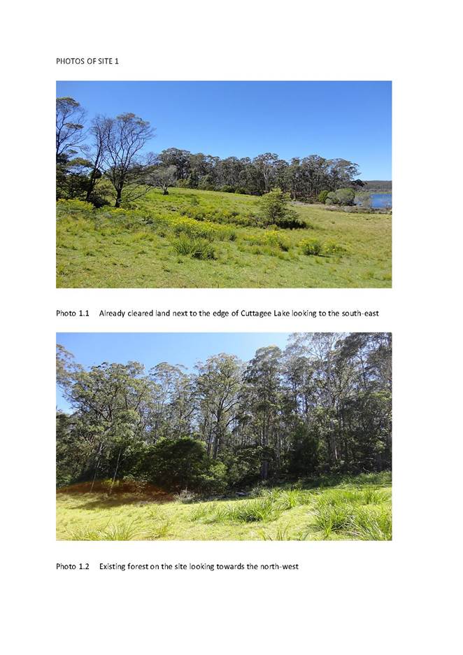
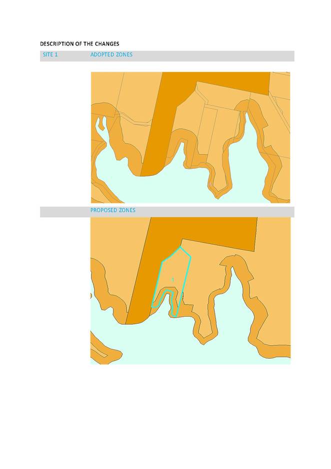
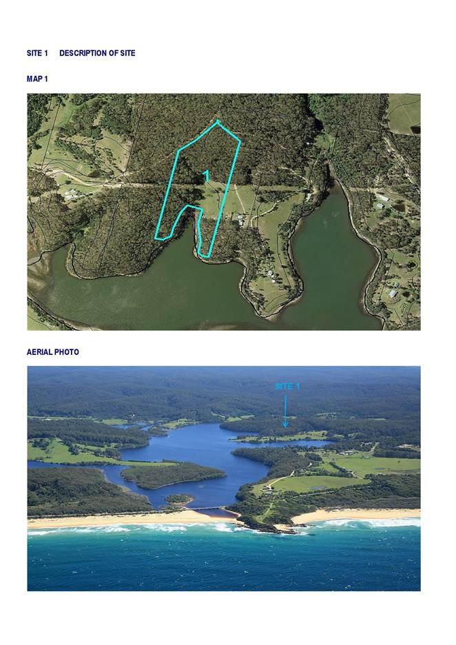
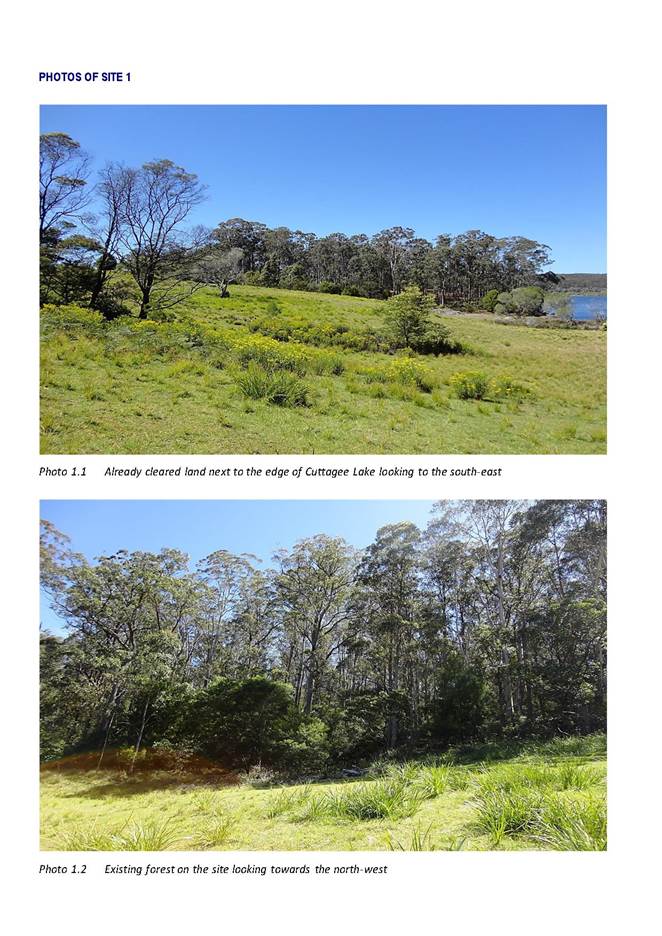
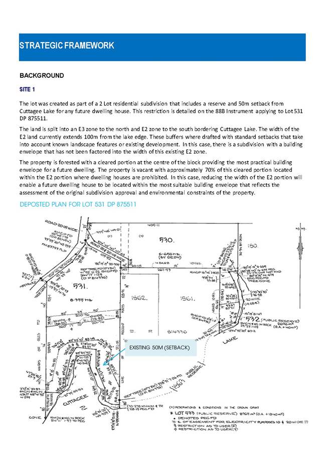
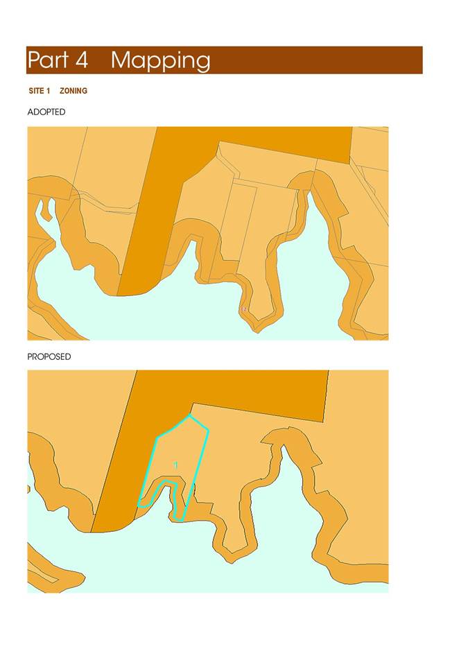
SITE 1 Cuttagee Lake
This property is a rectangular shaped allotment with a north-south orientation covering an area of 8.22ha located on the north side of Cuttagee Lake, south of Bermagui. A submission was received from the owner requesting a review of the width of the existing E2 Zone within the context of an existing approval on the land.
The land is forested with a cleared portion at the centre of the block providing the most practical building envelope for a future dwelling. The property is vacant with approximately 70% of this cleared portion being located within the existing E2 portion with dwelling houses a prohibited use in the zone under BVLEP 2013.
The subject lot was created as part of a 2 lot subdivision approval which included the requirements for a 50m setback restriction to Cuttagee Lake as a condition of consent
The land is split into an E3 Zone to the north and E2 Zone to the south bordering Cuttagee Lake. The width of the E2 land currently extends 100m from the lake edge. These E2 zone buffers where drafted as part of standard setbacks to take into account known landscape features or existing development as part of BVLEP 2013. It is considered that in this case reducing the width of the E2 zoned land would facilitate any future dwelling house being located within the most suitable area and would be consistent with the setback restriction. On this basis, it is recommended the width of the E2 Zone be reduced to 50m which would be consistent with the restriction on title.
Proposed Amendment
|
SITE |
PROPERTY |
EXISTING ZONE |
PROPOSED ZONE |
EXHIBITED LOT SIZE |
PROPOSED LOT SIZE |
|
1 |
LOT 531 DP 875511 |
E2 (Variable to 85m) |
E2 (50m) |
NA |
120ha (No Change) |
EXISTING E2 ZONE BOUNDARY
PROPOSED E2 ZONE BOUNDARY
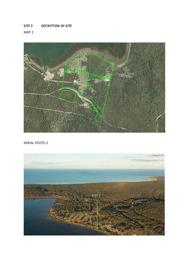
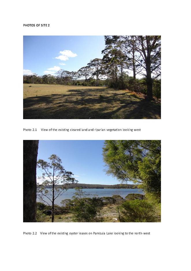
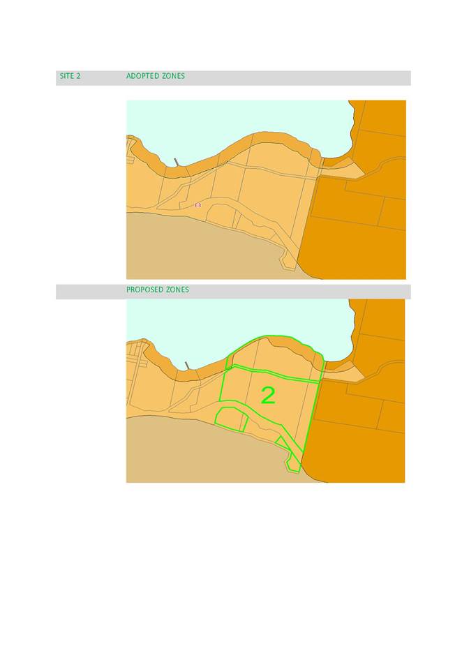
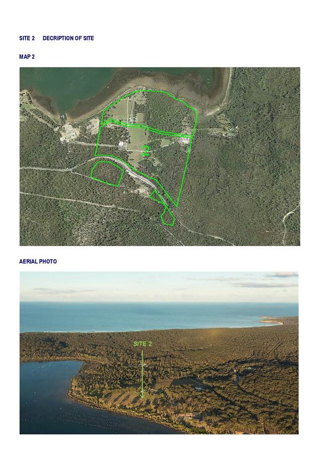
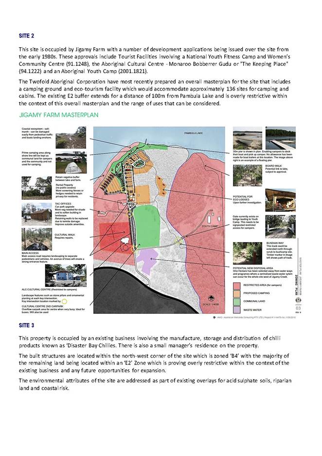
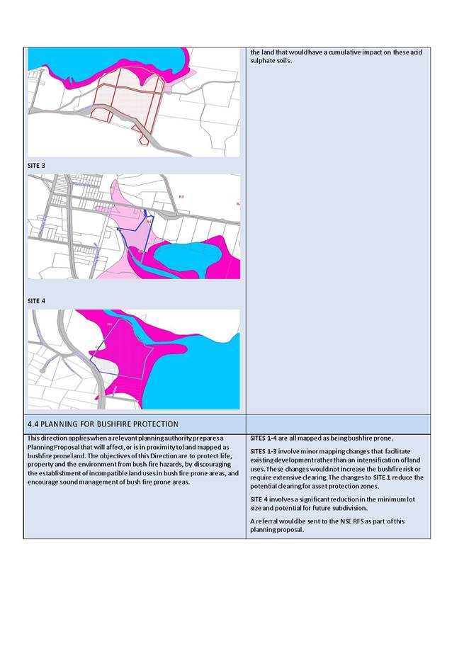
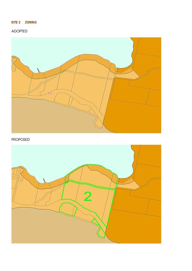
SITE 2 Jigamy Farm
This site is a relatively large parcel covering an area of 57.4ha located just to the north of Eden.
A submission has been recently received from the Twofold Aboriginal Corporation requesting a review of the width of the existing E2 Zone within the context of a proposed masterplan for Jigamy Farm.
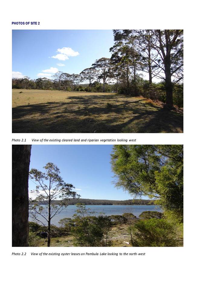
The property has a broad range of landscape features, including lower lying riparian vegetation around the north-eastern portion and cleared land through the centre. The site adjoins Pambula Lake with priority oyster leases to the north.
‘Jigamy Farm’ has had a number of Development Applications issued since the early 1980s. These approvals included Tourist Facilities like the Aboriginal Cultural Centre - Monaroo Bobberrer Gudu "The Keeping Place" (94.1222).
The Twofold Aboriginal Corporation have most recently prepared a masterplan for the site that includes a camping ground and eco-tourism facility including 136 sites for camping and cabins.
The existing E2 buffer extends for a distance of 100m from Pambula Lake over land already cleared, which is limiting the opportunities for the future uses that have been identified within this masterplan such as camping.
After an assessment of this property, it has been determined the width of this buffer could be reduced without having any additional impact on the site or Pambula Lake.
This change is considered to be of minor significance and supported within the context of the future masterplan for Jigamy Farm.
A reduction in the width of the existing E2 Zone to a width of 20m will broaden the range of land uses but ensure the existing riparian vegetation is still protected.
Proposed Amendment
|
SITE |
PROPERTY |
EXISTING ZONE |
PROPOSED ZONE |
EXHIBITED LOT SIZE |
PROPOSED LOT SIZE |
|
2 |
“JIGAMY FARM” LOTS 25 AND 43 DP 750242 AND LOT 243 DP 1112013 |
E2 (100m Buffer) |
E2 (20m Buffer) |
NA |
5ha (No Change) |
EXISTING ZONE BOUNDARY
PROPOSED ZONE BOUNDARY
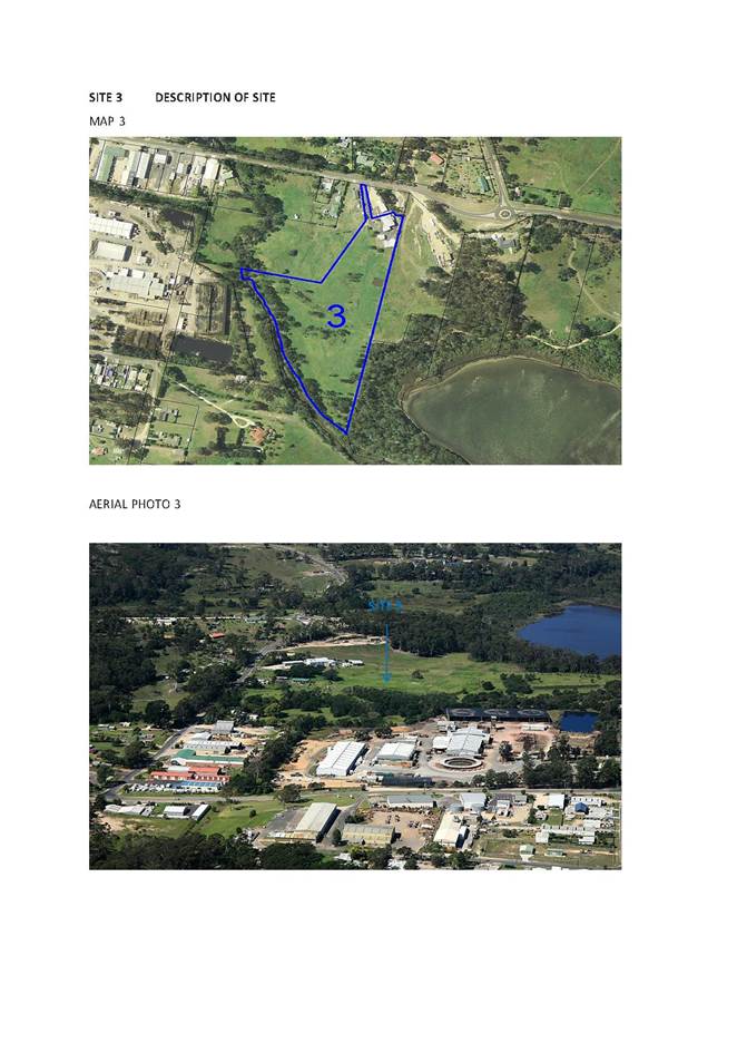
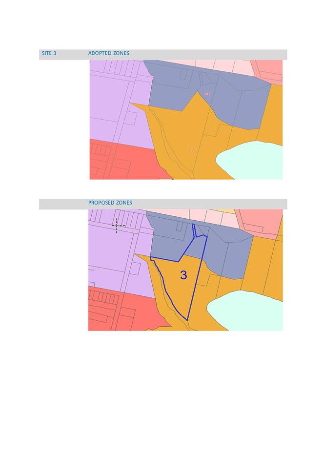
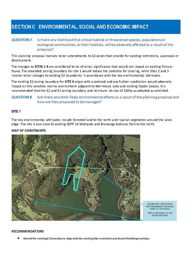
SITE 3 Disaster Bay Chillies
This is a small parcel of land covering an area of 4.67ha on the northern industrial fringe of Eden. The owners of this property have requested a review of the existing E2 Zone within the context of the site and neighbouring properties within the B4 Mixed Use Zone. The majority of the site is cleared with remnant wetland vegetation that forms part of the upper catchment of Lake Curalo. The site is occupied by an existing business and small manager's residence involved with the manufacture, storage and distribution of chilli products known as ‘Disaster Bay Chillies’. The built structures are located within the north-west corner of the site which is zoned B4, with the majority of the remaining land being located within an E2 Zone which is proving overly restrictive within the context of the existing business and any future expansion.
A minor reduction in the area of the E2 Zone that covers the majority of the site to provide some scope for expansion of the B4 Zone is considered reasonable, as overlays are already in place to guide an assessment of the key environmental attributes of the land.
|
SITE |
PROPERTY |
EXISTING ZONE |
PROPOSED ZONE |
EXHIBITED LOT SIZE |
PROPOSED LOT SIZE |
|
3 |
LOT 35 DP 843393 |
E2 (4.2ha)and B4 (5,000m2) |
E2 (3.9) and B4 (8,000m2) |
NA |
NA |
EXISTING ZONE BOUNDARY
PROPOSED
ZONE BOUNDARY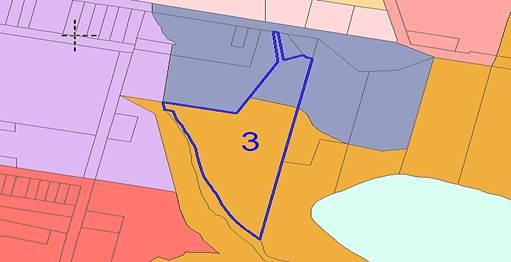
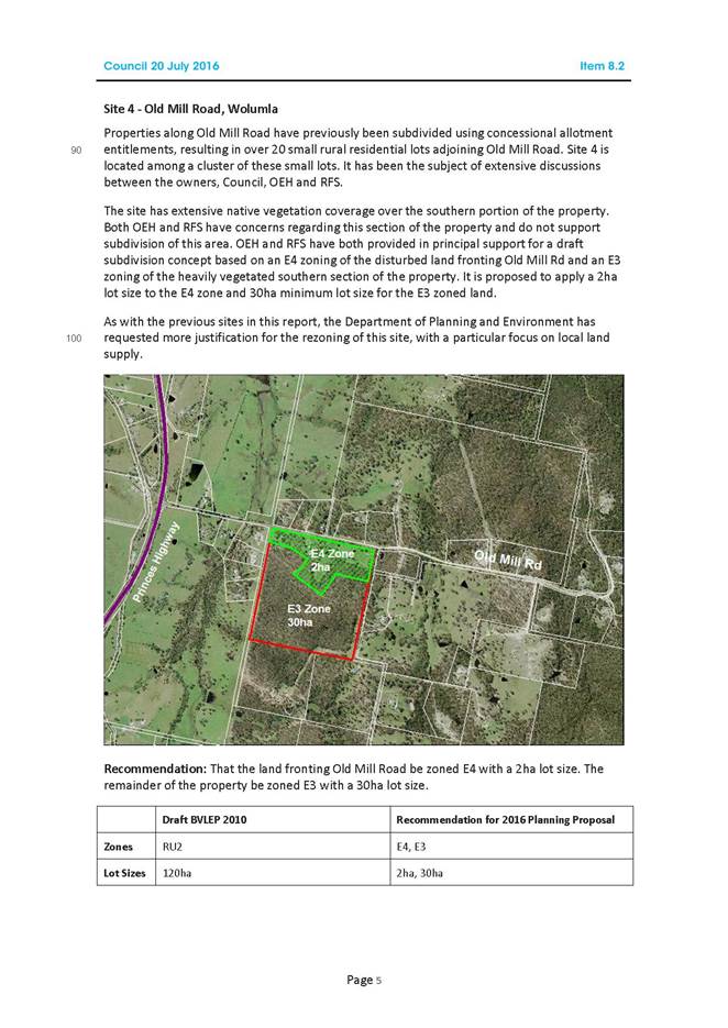
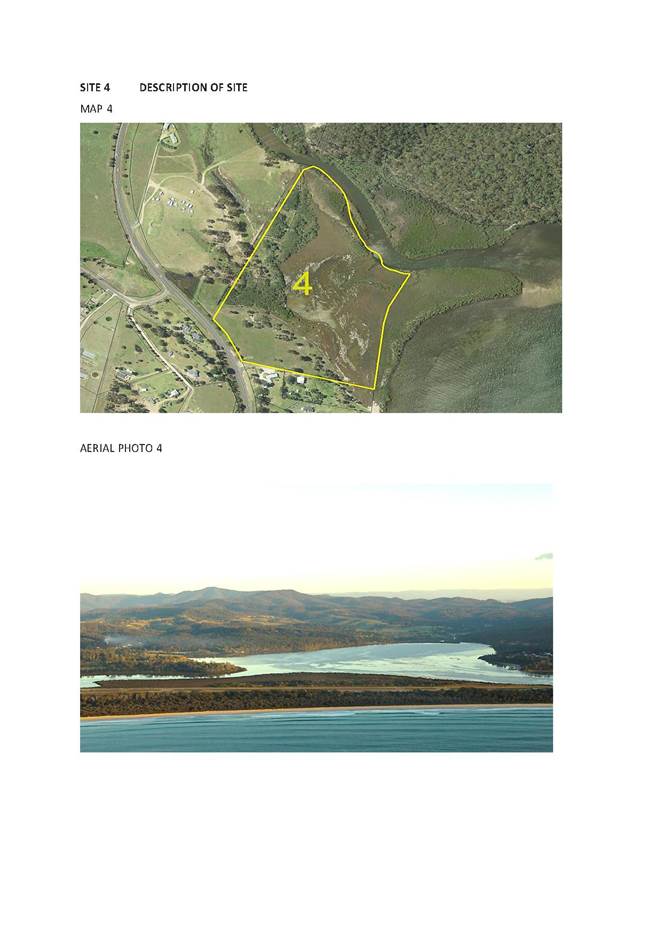
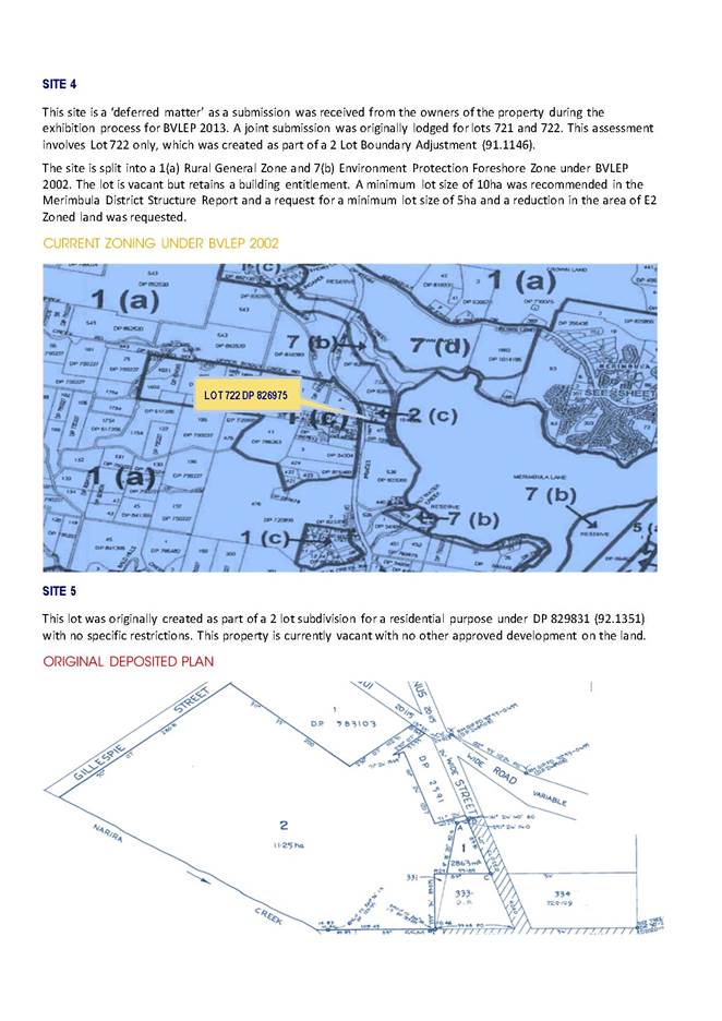
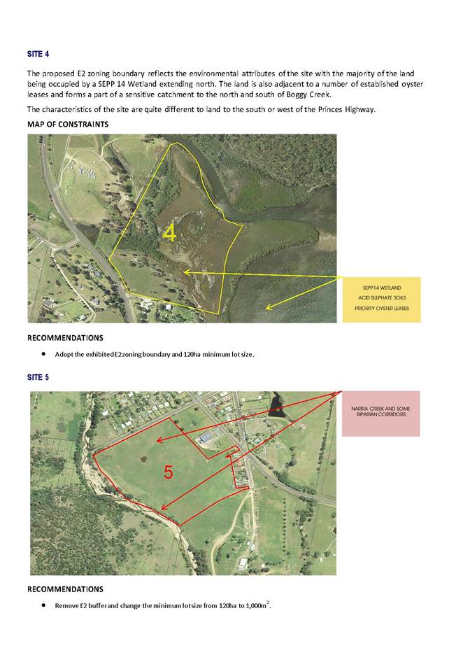
SITE 4 Millingandi
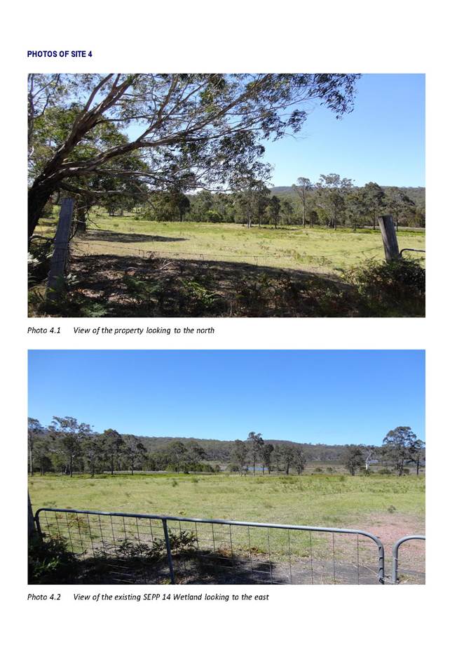
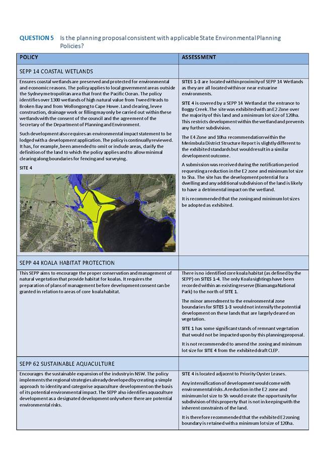
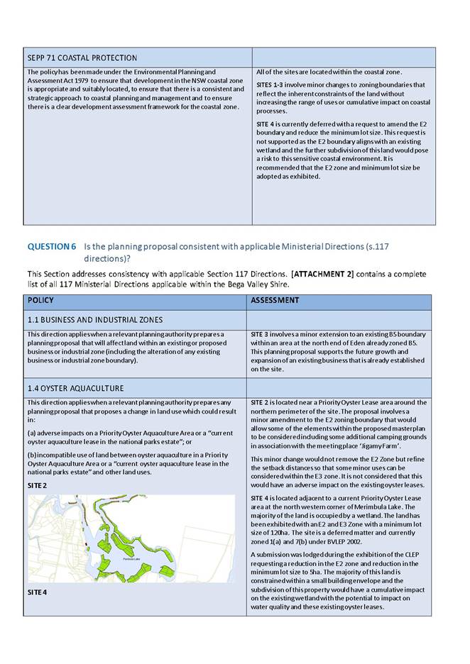
The site covers an area of 15.6ha with the majority of this land being occupied by a SEPP 14 wetland located adjacent to existing priority oyster leases.
This site is a ‘Deferred Matter’ as a submission was received from the owners of the property during the exhibition process for BVLEP 2013.
A joint submission was originally lodged for lots 721 and 722. This assessment involves Lot 722 only, which was created as part of a 2 Lot Boundary Adjustment (91.1146). The site is split into a 1(a) Rural General Zone and 7(b) Environment Protection Foreshore Zone under BVLEP 2002 and the lot is vacant but retains a building entitlement.
A minimum lot size of 10ha was recommended in the Merimbula District Structure Report and a request for a minimum lot size of 5ha and a reduction in the area of E2 Zoned land was requested.
Any expansion of the E3 Zone would extend into this wetland and a reduction of the minimum lot size would permit an additional 2 lots.
This request is likely to have a cumulative impact on the site and broader catchment of Merimbula Lake.
There is not sufficient justification for a change to the existing E2 boundary and the majority of any additional lots would be within 150m of Merimbula Lake posing a risk in terms of effluent disposal.
It is therefore recommended this site proceed as exhibited with an E2 zoning boundary that aligns with the wetland with a 120ha lot size to restrict any further subdivision of the land.
The 120ha minimum lot size will not prevent the consideration of a future dwelling as the land retains a building entitlement.
Proposed Amendment
|
SITE |
PROPERTY |
EXHIBITED ZONE |
EXISTING ZONE |
EXHIBITED LOT SIZE |
PROPOSED LOT SIZE |
|
4 |
LOT 722 DP 826975 |
E2 and E3 |
1(a) BVLEP 2002 |
120ha |
120ha |
ZONING (AS EXHIBITED)
LOT SIZE (AS EXHIBITED)
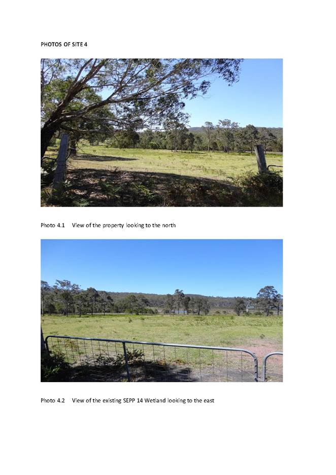
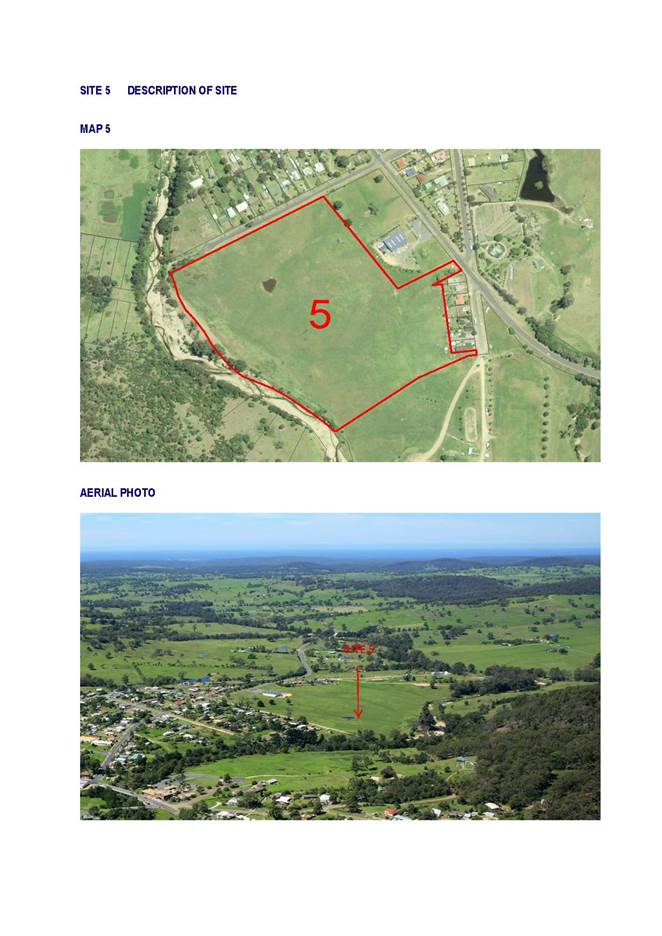
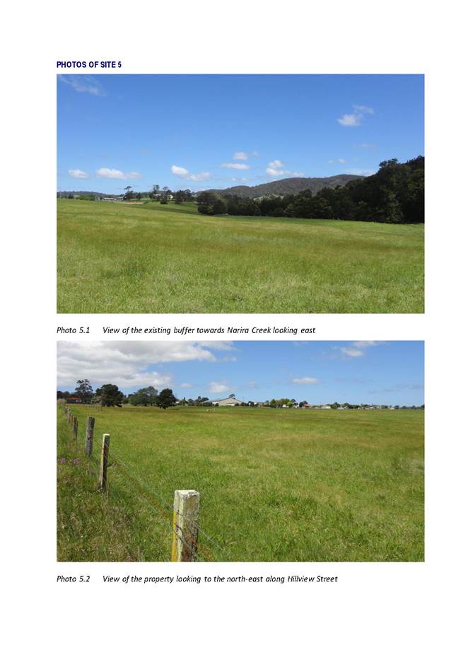
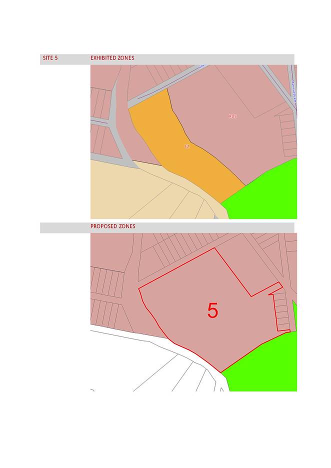
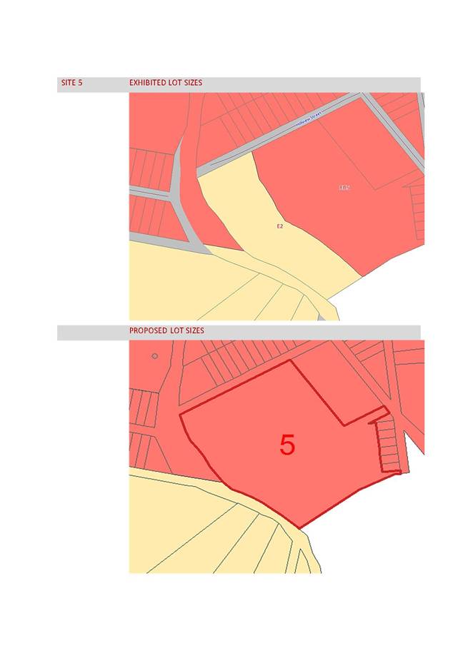
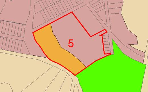
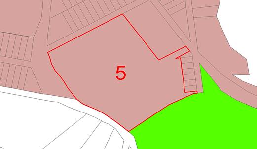
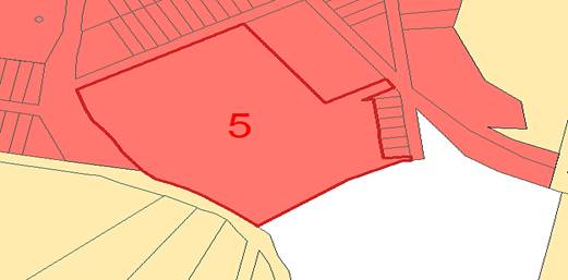
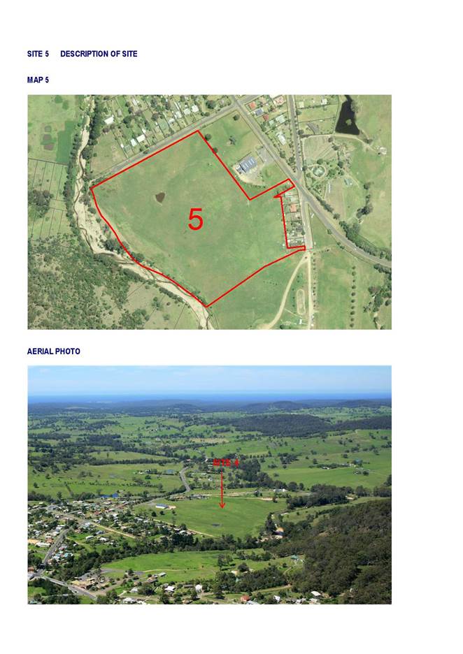
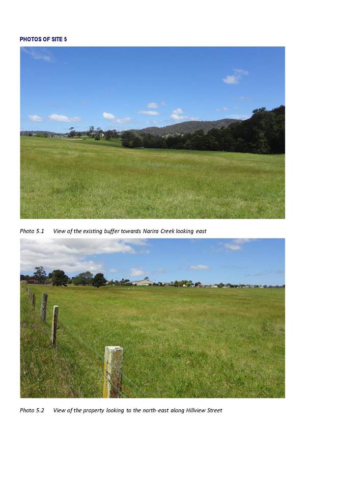
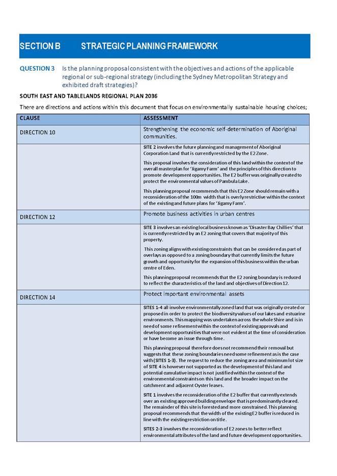
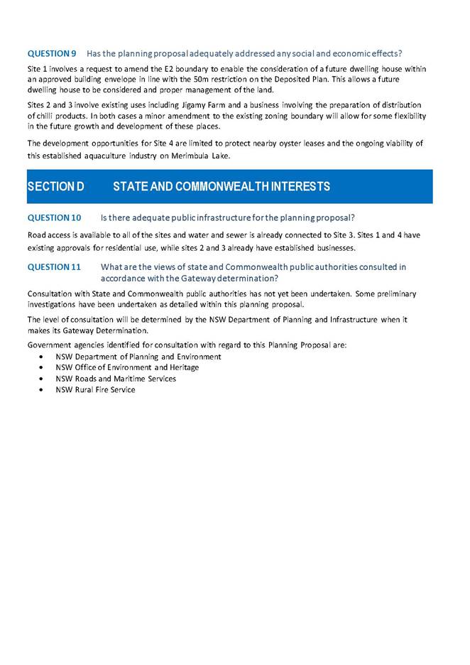
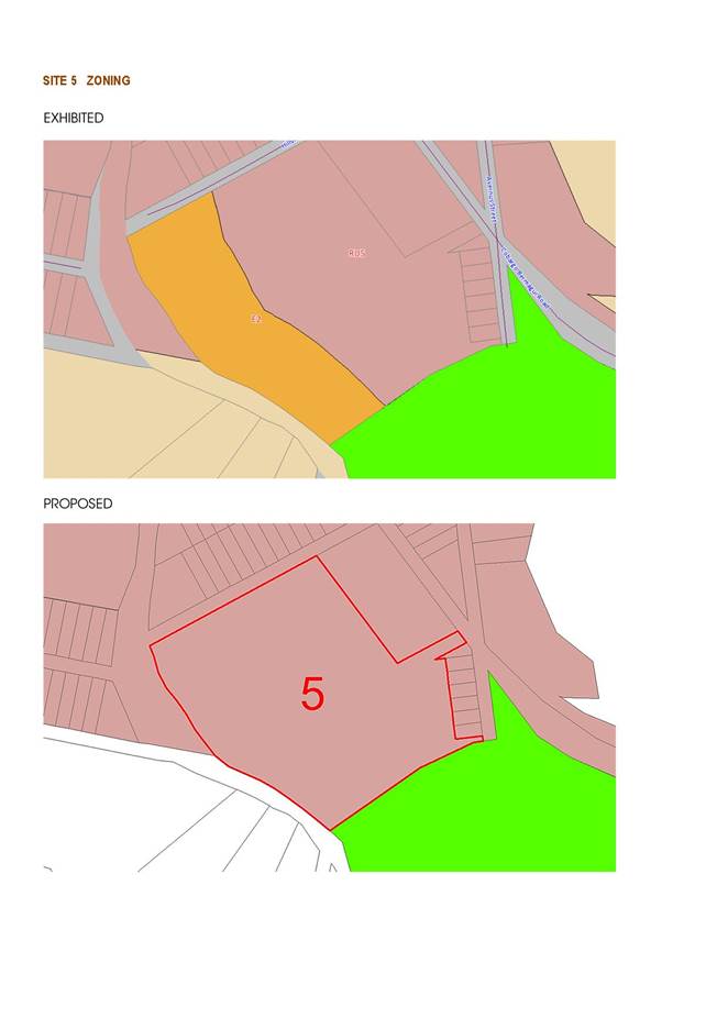
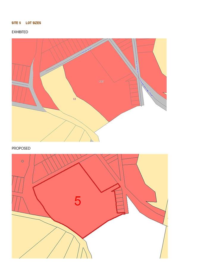
SITE 5 Cobargo
This site is located along the southern boundary of Cobargo covering an area of 10.72ha of land that is predominantly cleared.
Concern was raised by the owner of the land regarding the appropriateness of the E2 zoning of the land who considered the E2 zone was no longer necessary.
There are some minor riparian corridors extending down to Narira Creek but the majority of this property is free of constraints. This E2 Zone was originally intended as a buffer area for a proposed industrial zoning of a neighbouring property as part of the Draft BVLEP 2010.
During the submission period, this IN2 Light Industrial Zone was revised in favour of a RU5 Village Zone, but the E2 Zone with a 120ha minimum lot size has remained. This (4ha) buffer is no longer required given the industrial zone never proceeded.
It is therefore recommended this E2 be replaced with a RU5 Village Zone and the existing 120ha minimum lot size be amended to a 1,000m2 minimum lot size consistent with the rest of the site and village of Cobargo.
Proposed Amendment
|
SITE |
PROPERTY |
EXISTING ZONE |
PROPOSED ZONE |
EXHIBITED LOT SIZE |
PROPOSED LOT SIZE |
|
5 |
Lot 22 DP 1013450 |
E2 |
RU5 |
1,000m2 and 120ha |
1,000m2 |
EXISTING ZONE
PROPOSED ZONE
EXISTING LOT SIZE
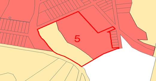
PROPOSED LOT SIZE
Conclusion
This report seeks Council's endorsement to present this planning proposal to the Department of Planning for Determination at Gateway. The purpose of this Planning Proposal is to make minor amendments to the E2 zoning boundaries of sites 1-3, adopt the recommended zoning and minimum lot sizes as exhibited for site 4 and replace the existing E2 zoning and minimum lot size for site 5.
Attachments
1⇩. Description of the Sites
2⇩. Description of the Changes
3⇩. Draft Planning Proposal Mapping of Environmental Zones
|
1. That Council resolve to adopt the recommendations for Sites 1-5 as identified in Attachment 2 to this report. 2. That Council officers be authorised to forward this Planning Proposal for Mapping of Environmental Zone to the Department of Planning for Gateway Determination in accordance with the recommendations contained within this report. 3. That following Gateway Determination, the Planning Proposal be placed on public exhibition and following the exhibition period, a further report be submitted to Council summarising the submissions received during the exhibition period. 4. That should no submissions be received during the exhibition period officers progress the Planning Proposal to finalisation and gazettal without a further report to Council. |
|
13 December 2017 |
|
|
Item 9.4 - Attachment 3 |
Draft Planning Proposal Mapping of Environmental Zones |
|
Item 9.5 |
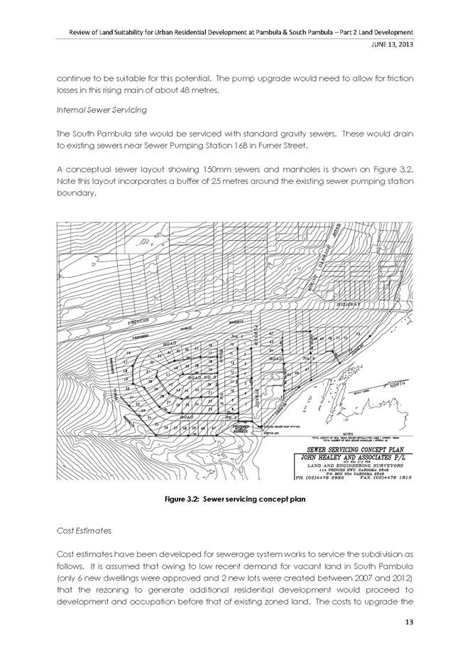
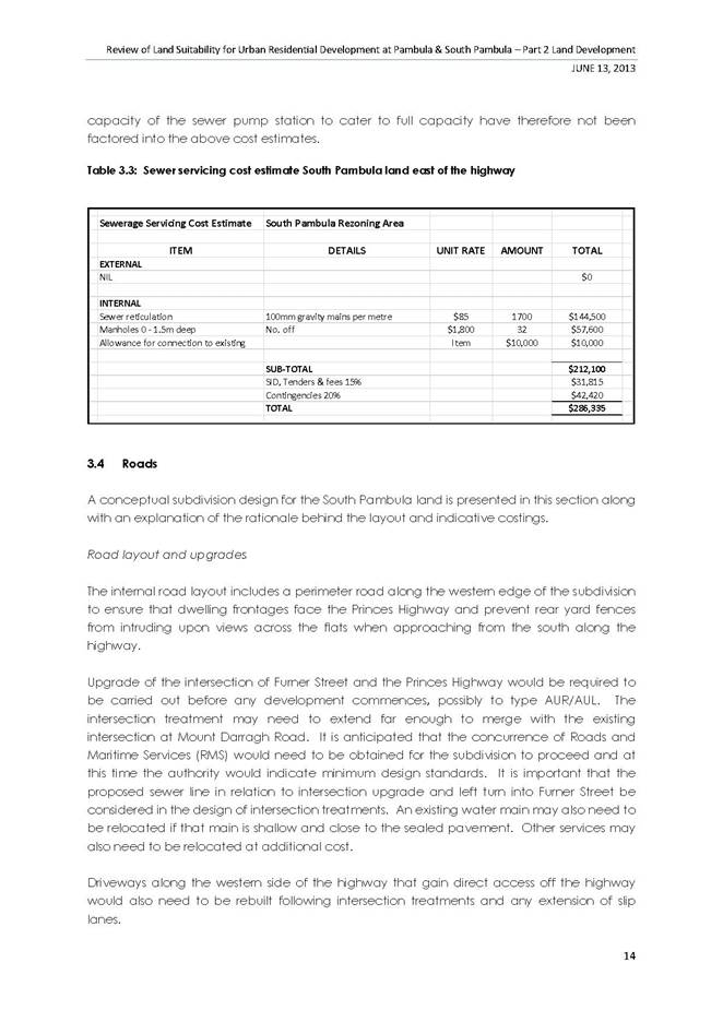
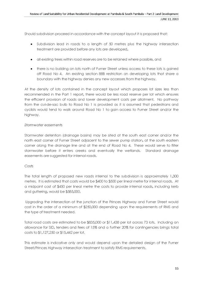
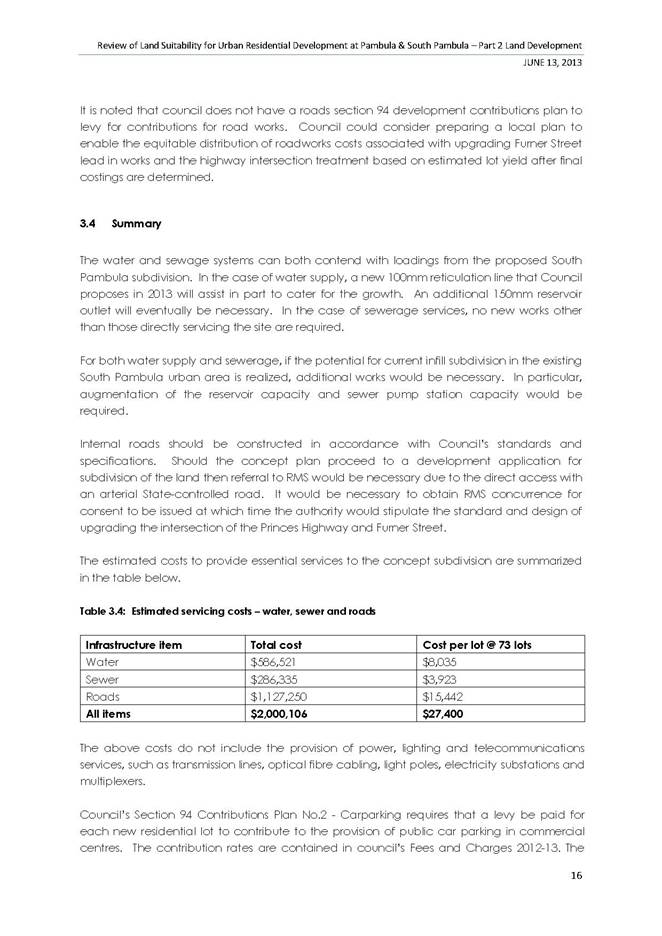
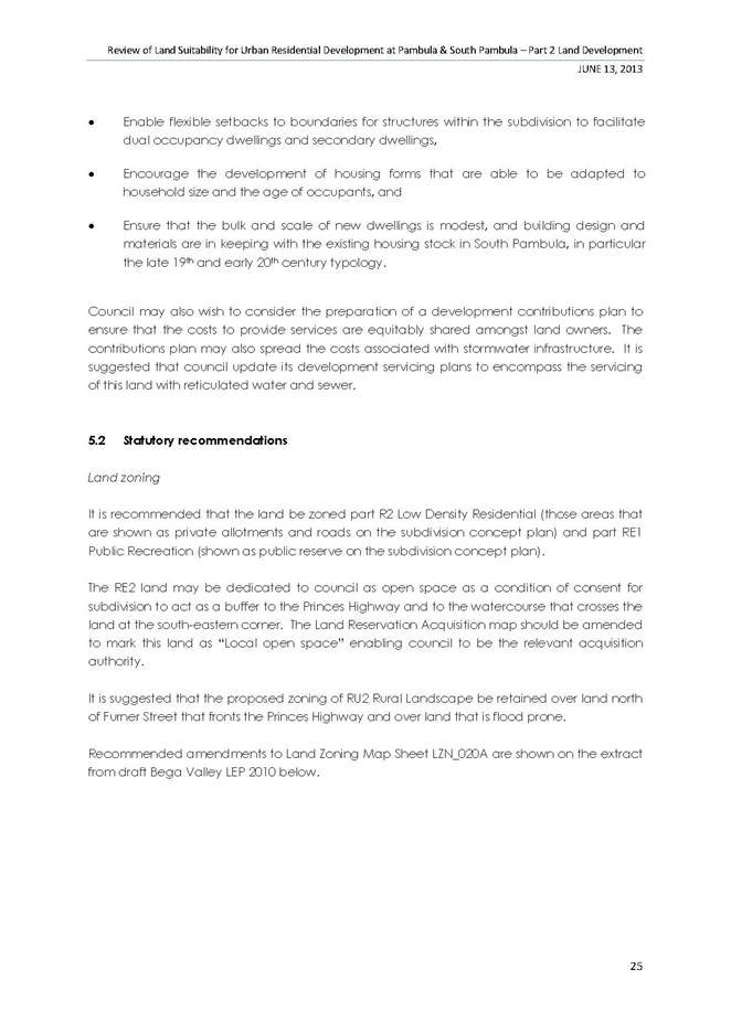
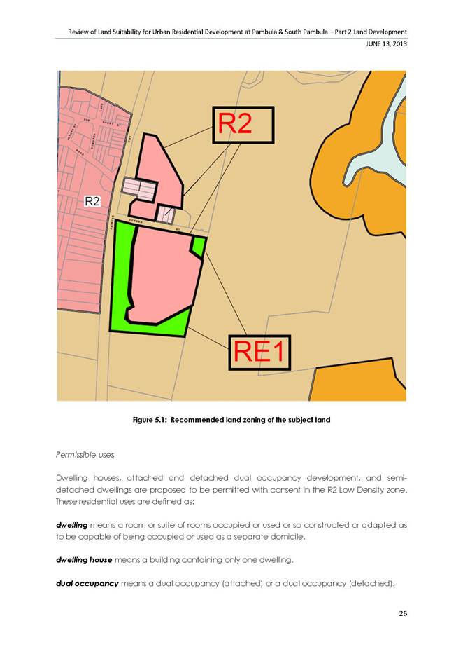
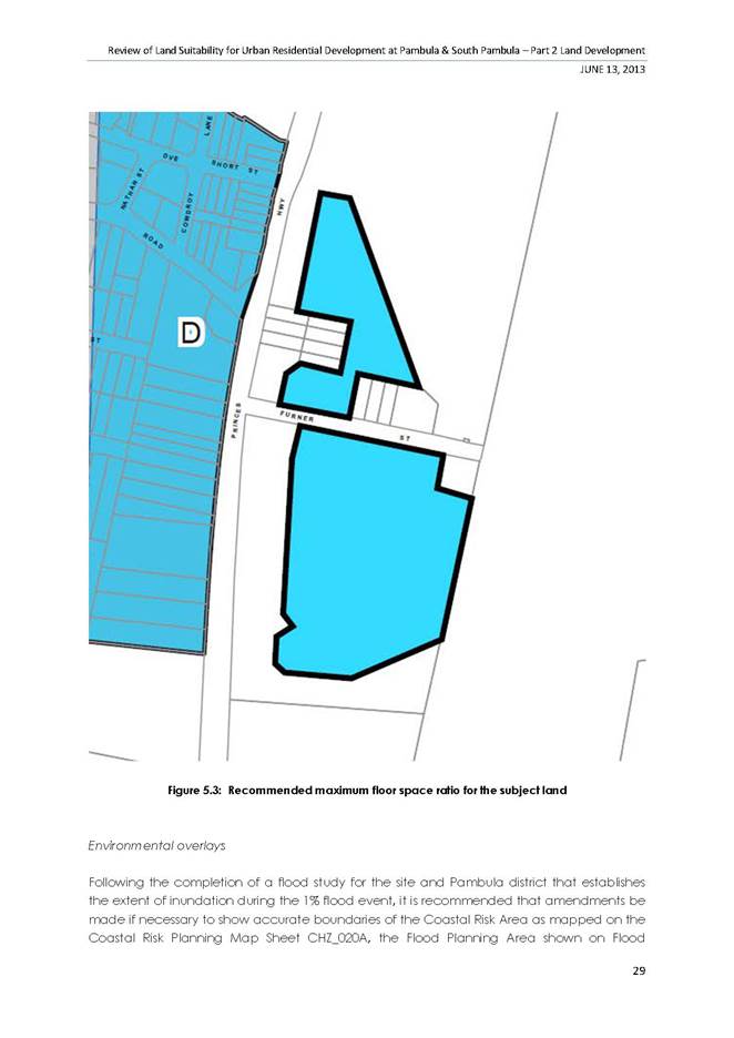
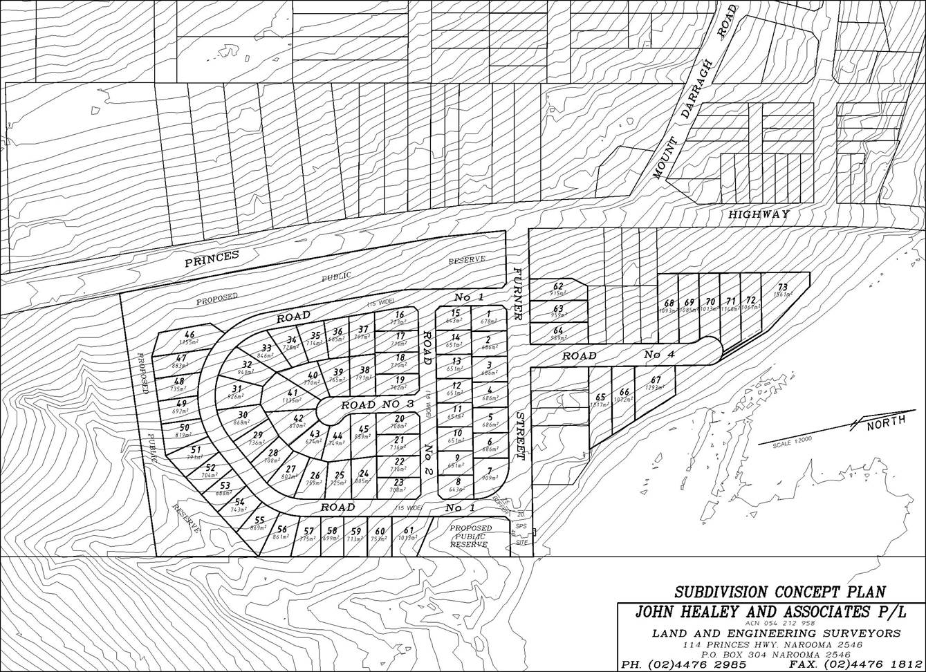
9.5. Planning Proposal Rural Residential Land South Pambula
This report seeks Council’s resolution to prepare a planning proposal for two deferred sites at South Pambula involving changes to exhibited zones and lot sizes.
Acting Director Planning and Environment
Background
The gazettal of Bega Valley Local Environmental Plan (BVLEP 2013) resulted in a number of sites that were identified as ‘deferred matters’ , that would be subject to further assessment and consideration by Council , including the two sites the subject of this report
The purpose of this report is to seek Council’s endorsement for the following two sites to be included in a planning proposal for lodgement with the Department of Planning.
Property Descriptions
|
SITE |
DESCRIPTION |
EXHIBITED ZONES |
AMENDED ZONES |
EXHIBITED LOT SIZES |
AMENDED LOT SIZES |
|
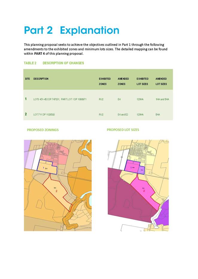
1 |
LOTS 451-453 DP 747031, PART LOT 1 DP 1088971 |
RU2 |
E4 |
120HA |
1HA and 5HA |
|
2 |
LOT 711 DP 1128593 |
RU2 |
E4 and E2 |
120HA |
5HA |
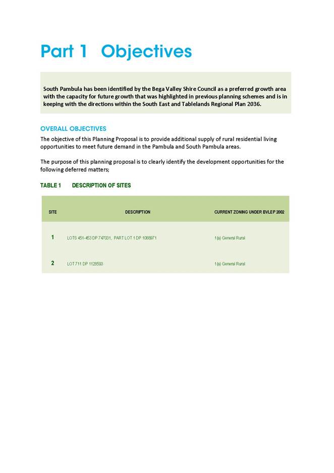
Objectives of the Planning Proposal
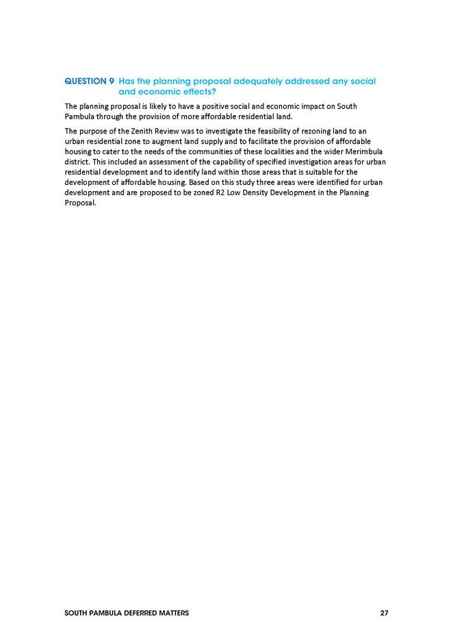
1) Is to provide additional supply of rural residential living opportunities to meet future demand in the Pambula and South Pambula areas.
2) To clearly identify the development opportunities for the above mentioned deferred matters.
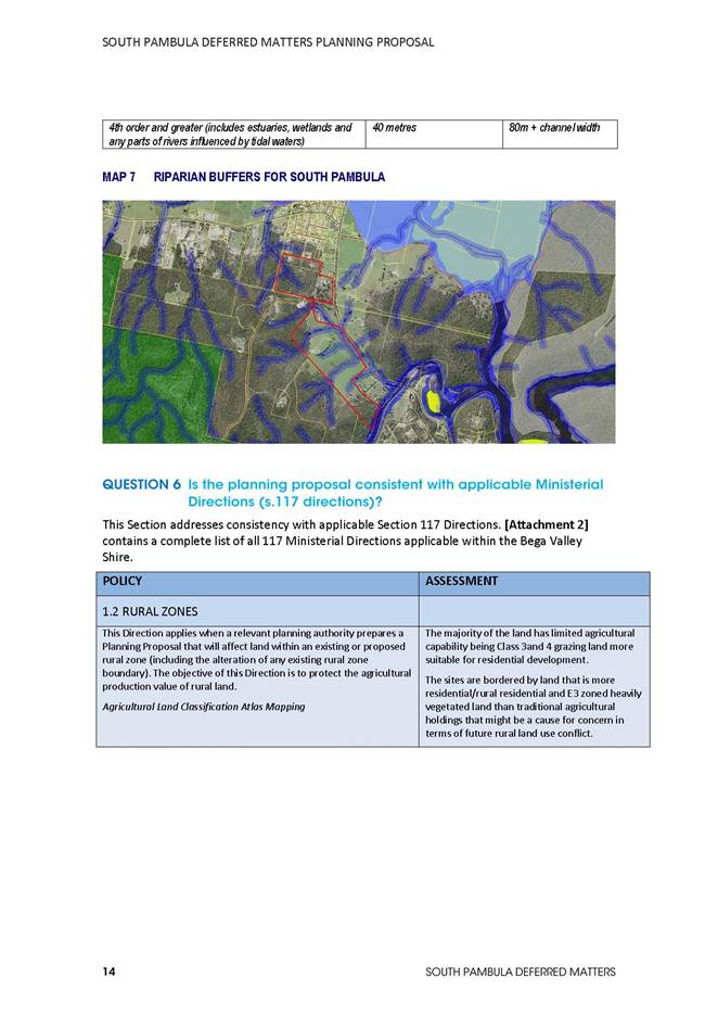
3) Retain the proposed E2 zone along environmentally sensitive land of Site 2 located along Nethercote Road.
Description of the Sites and Recommendations
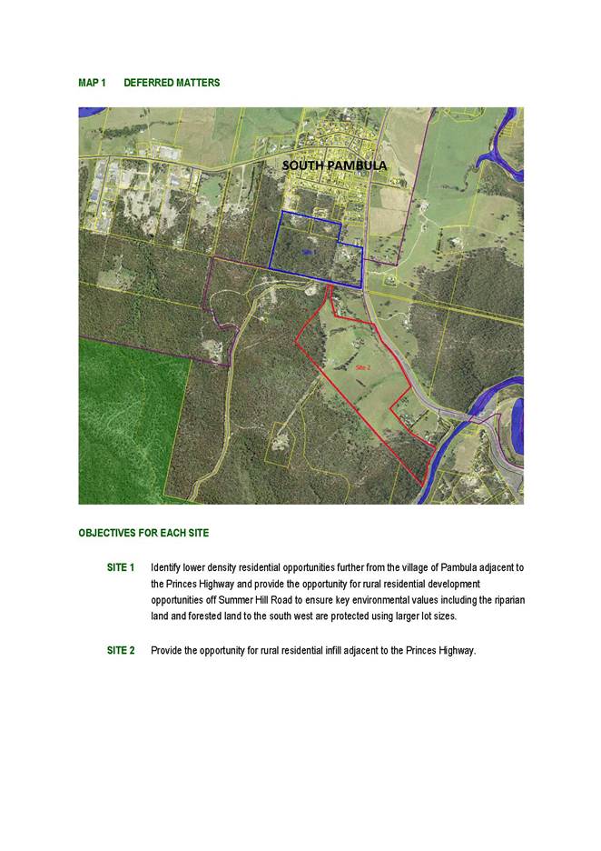
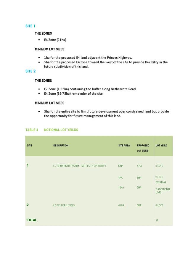
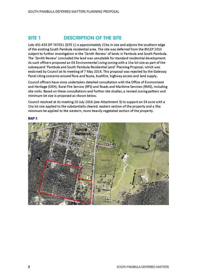
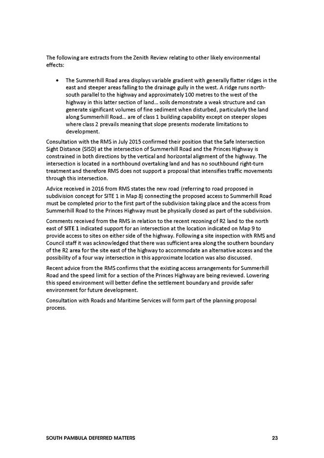
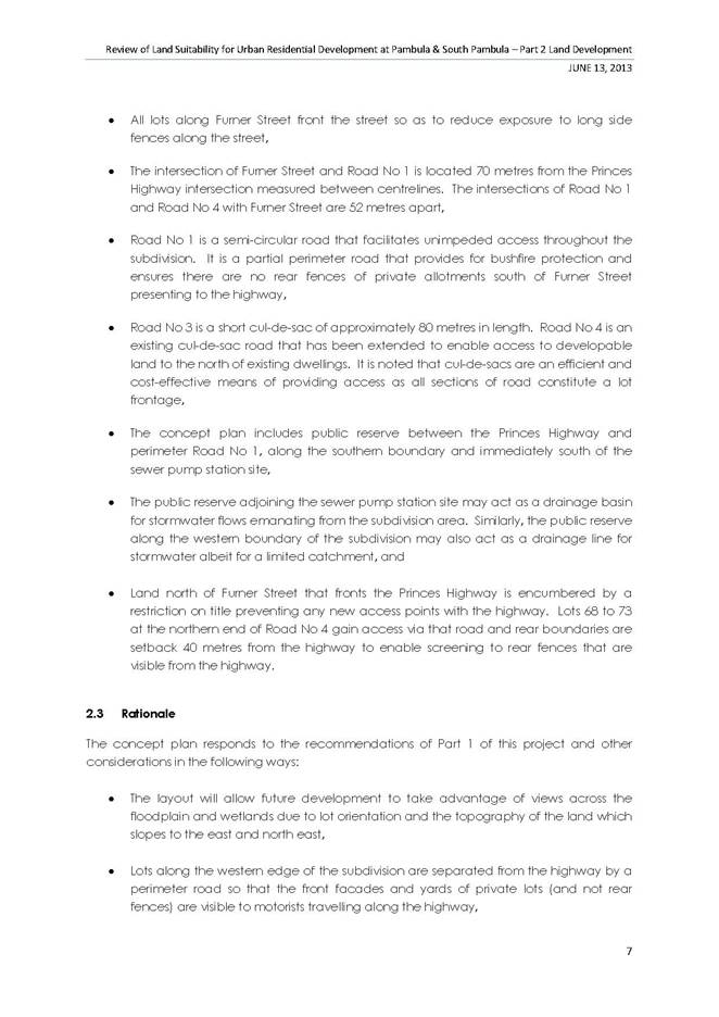
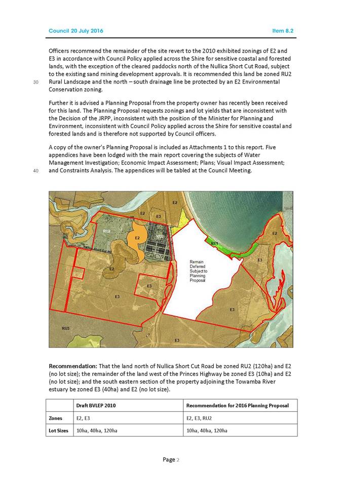
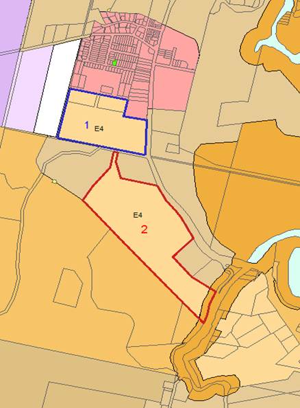
Site 1 Lots 451-453 DP 747031 Lloyd Street/Princes Highway, South Pambula
Lots 451-453 DP 747031 (Site 1) is approximately 21ha in size and adjoins the southern edge of the existing South Pambula residential area. The site was deferred from the BVLEP 2013 subject to further investigation in the ‘Zenith Review’ of lands in Pambula and South Pambula. The ‘Zenith Review’ concluded the land was unsuitable for standard residential development. As such officers proposed an E4 Environmental Living zoning with a 1ha lot size as part of the subsequent ‘Pambula and South Pambula Residential Land’ Planning Proposal, which was endorsed by Council at its meeting of 7 May 2014. This proposal was rejected by the Gateway Panel citing concerns around flora and fauna, bushfire, highway access and land supply.
Council officers have since undertaken detailed consultation with the Office of Environment and Heritage (OEH), Rural Fire Service (RFS) and Roads and Maritime Services (RMS), including site visits. Based on these consultations and further site studies, a revised zoning pattern and minimum lot size is proposed as shown below.
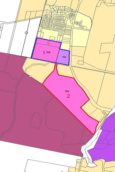
Council resolved at its meeting 20 July 2016 to support an E4 zone with a 1ha lot size applied to the substantially cleared, eastern section of the property and a 5ha minimum be applied to the western, more heavily vegetated section of the property.
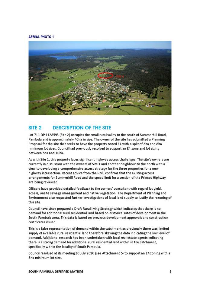
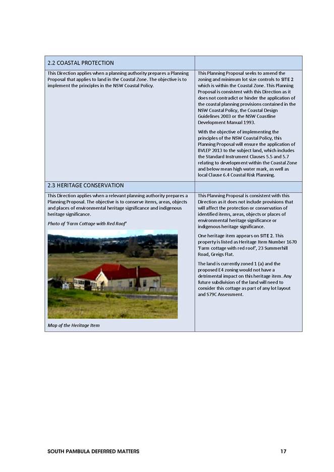
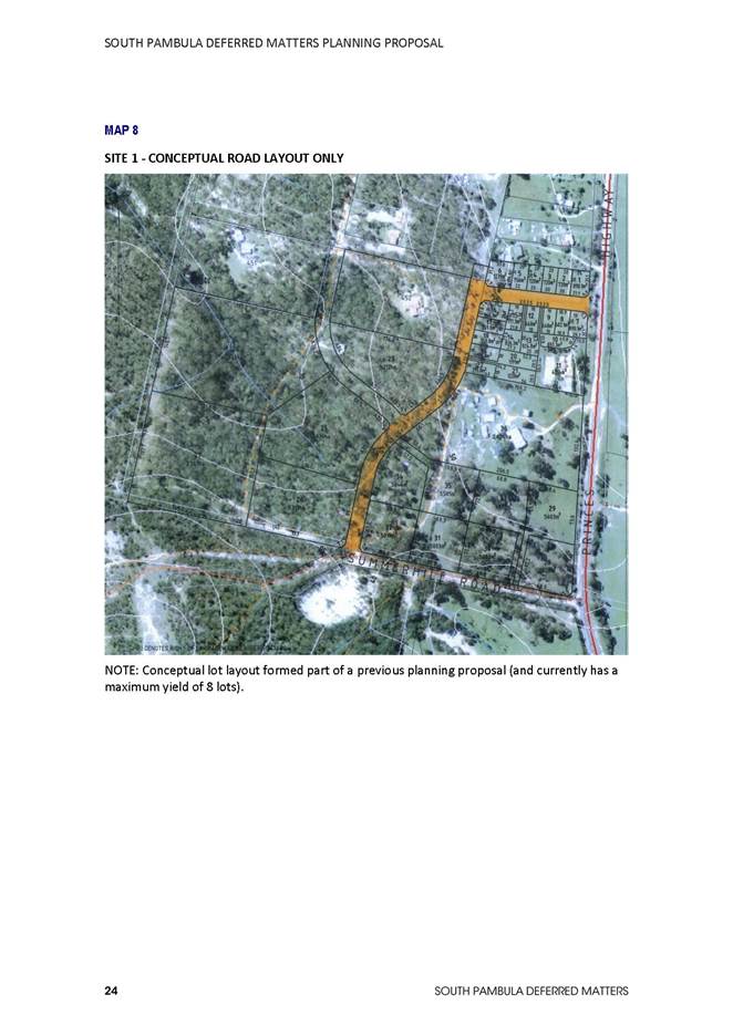
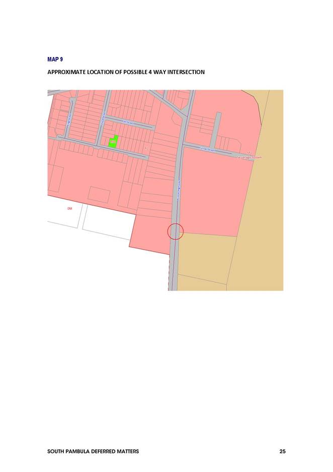
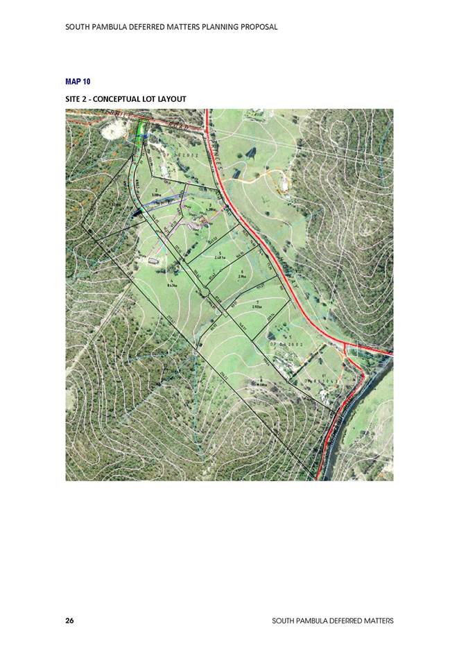
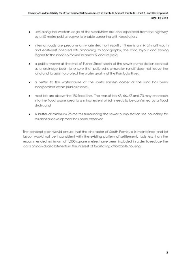
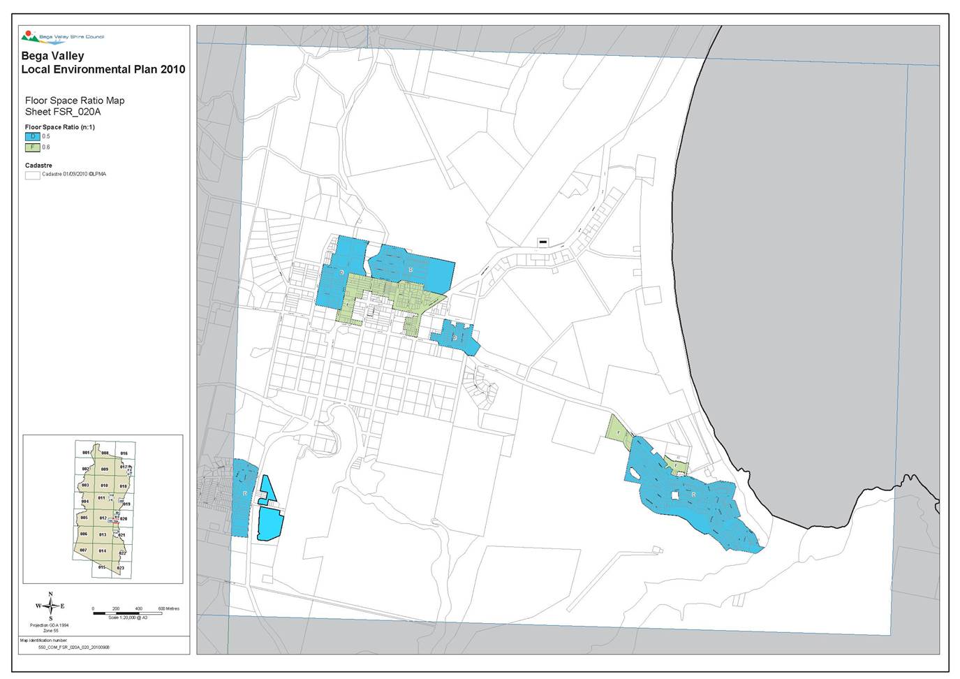
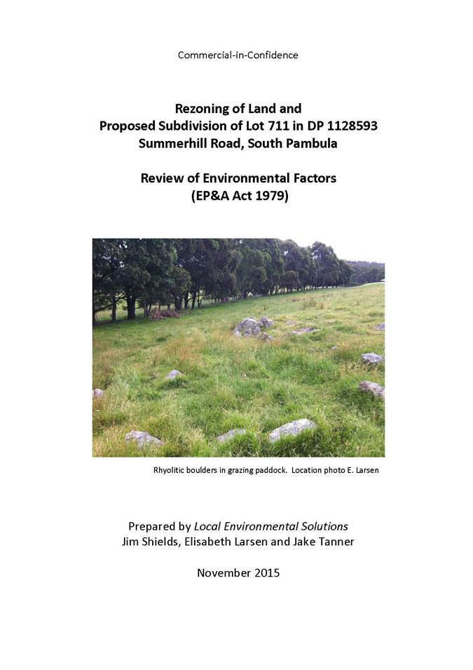
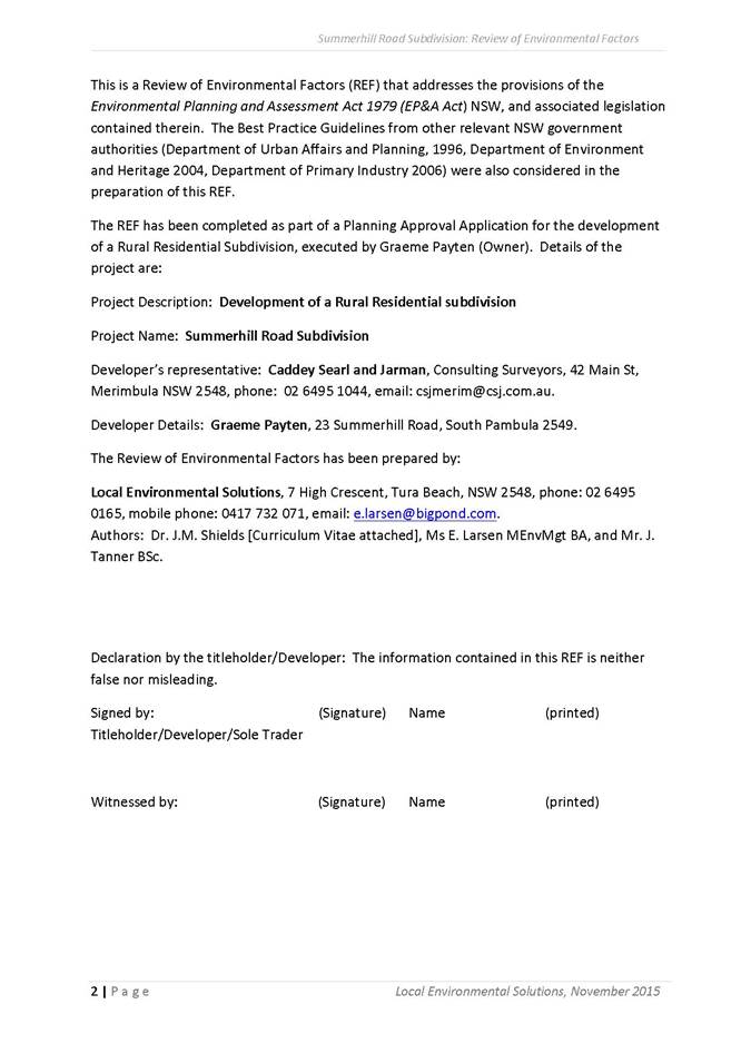
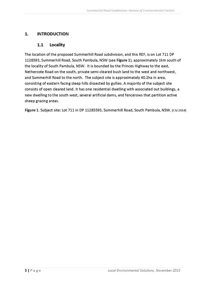
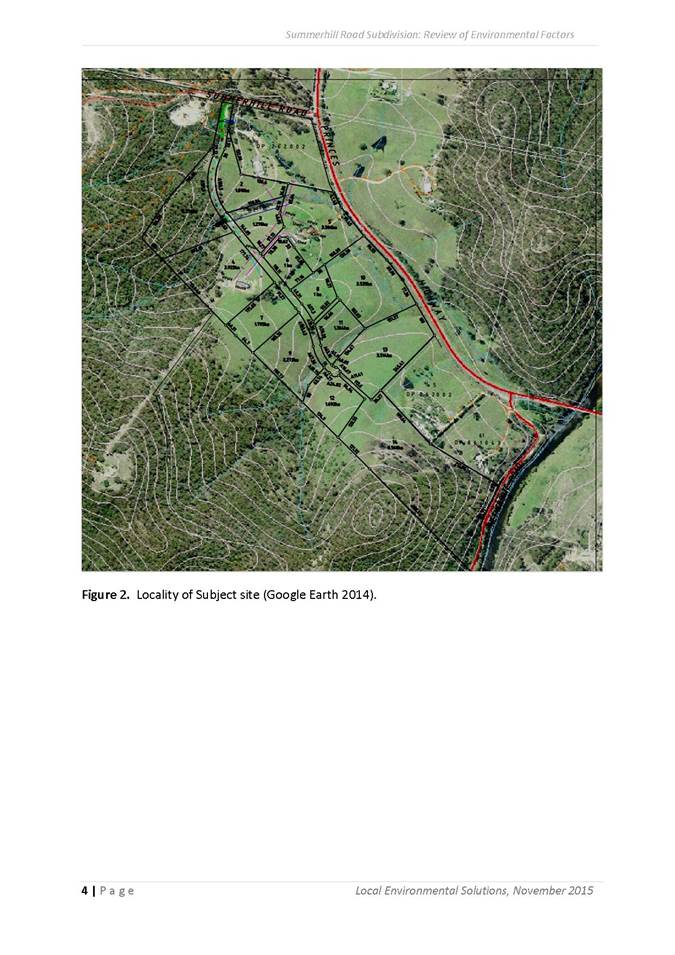
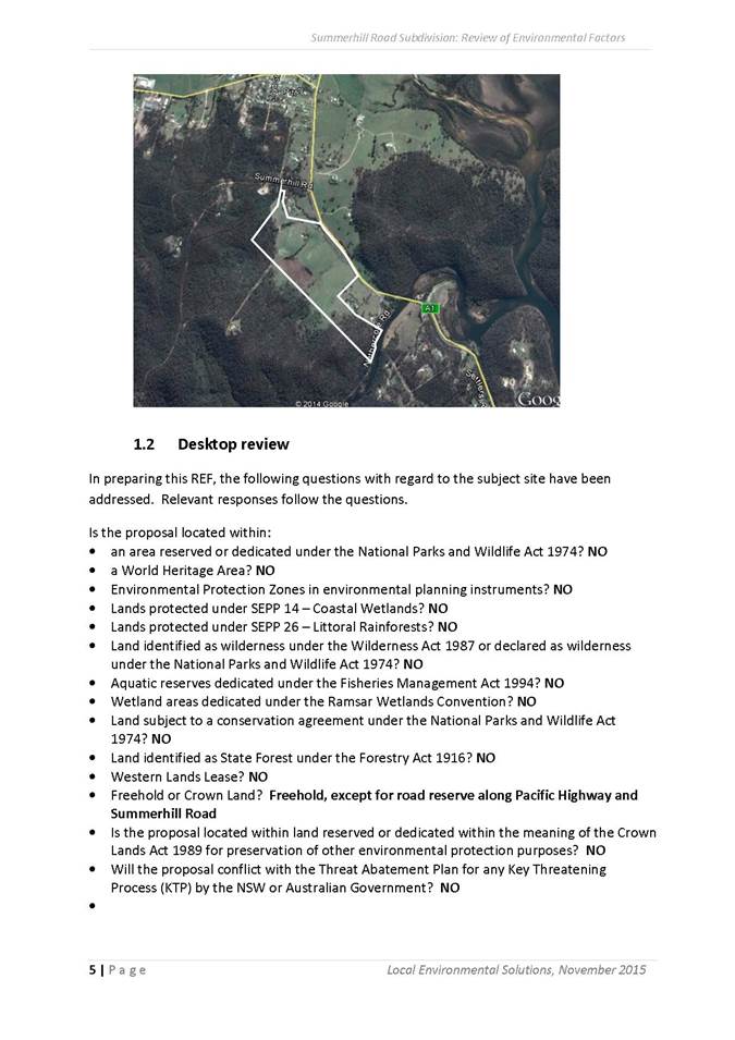
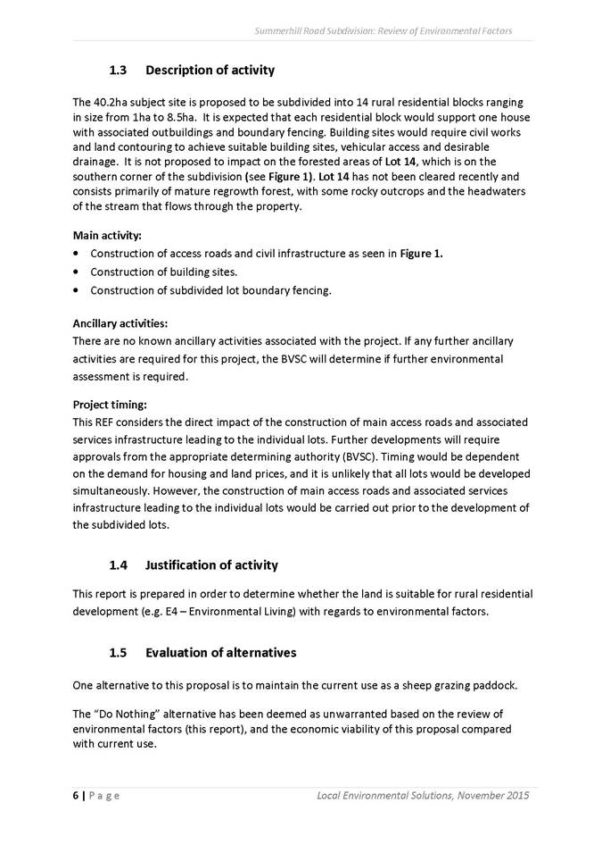
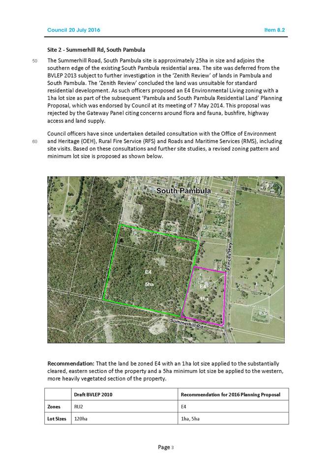
SITE 2 Lot 711 DP 1128593 23 Summerhill Road, Greigs Flat
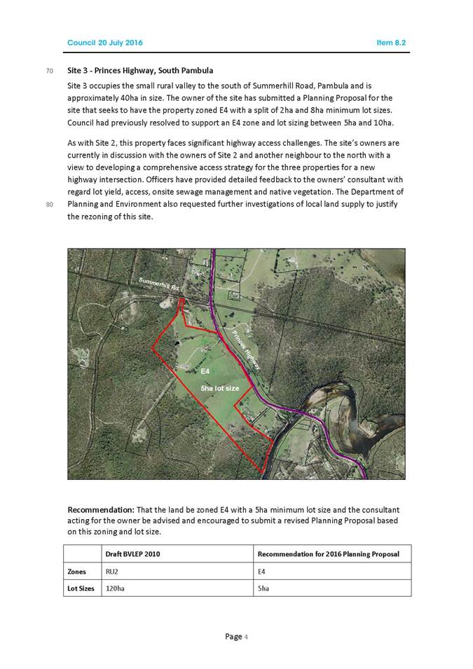
Lot 711 DP 1128593 (Site 2) occupies the small rural valley to the south of Summerhill Road, Pambula and is approximately 40ha in size. The owner of the site has submitted a Planning Proposal for the site that seeks to have the property zoned E4 with a split of 2ha and 8ha minimum lot sizes. Council had previously resolved to support an E4 zone and lot sizing between 5ha and 10ha.
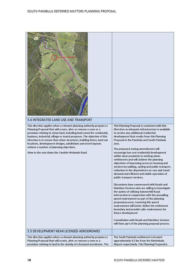
As with Site 1, this property faces significant highway access challenges. The site’s owners are currently in discussion with the owners of Site 1 and another neighbour to the north with a view to developing a comprehensive access strategy for the three properties for a new highway intersection. Recent advice from the RMS confirms that the existing access arrangements for Summerhill Road and the speed limit for a section of the Princes Highway are being reviewed.
Officers have provided detailed feedback to the owners’ consultant with regard lot yield, access, onsite sewage management and native vegetation. The Department of Planning and Environment also requested further investigations of local land supply to justify the rezoning of this site.
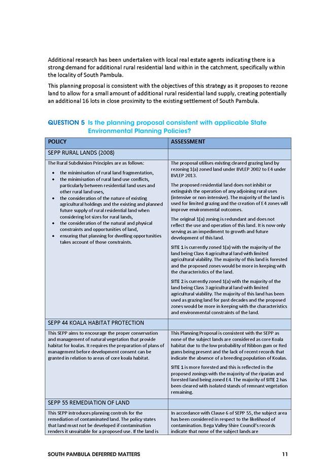
There is limited supply of available rural residential land in the South Pambula area. Research has been undertaken with local real estate agents indicating there is a strong demand for additional rural residential land within in the catchment, specifically within the locality of South Pambula.
Council at its meeting held on 20 July 2016 resolved to support an E4 zoning with a 5ha minimum lot size.
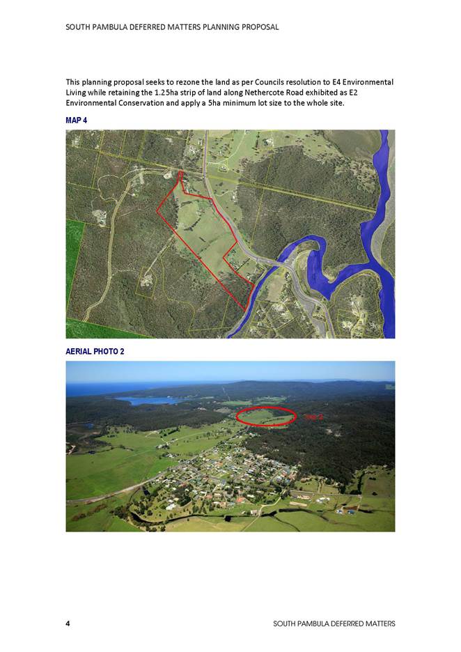
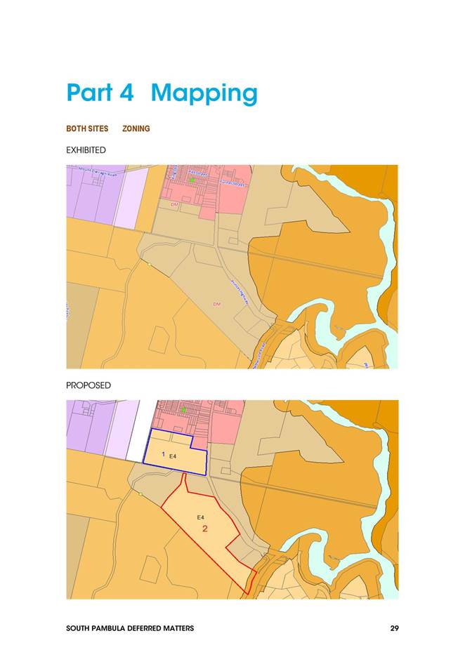
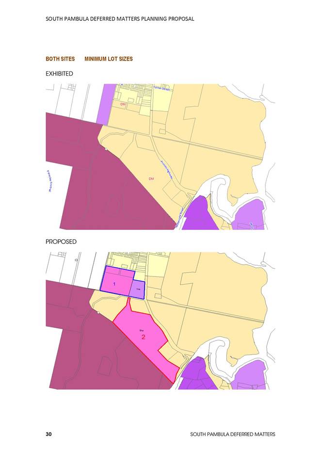
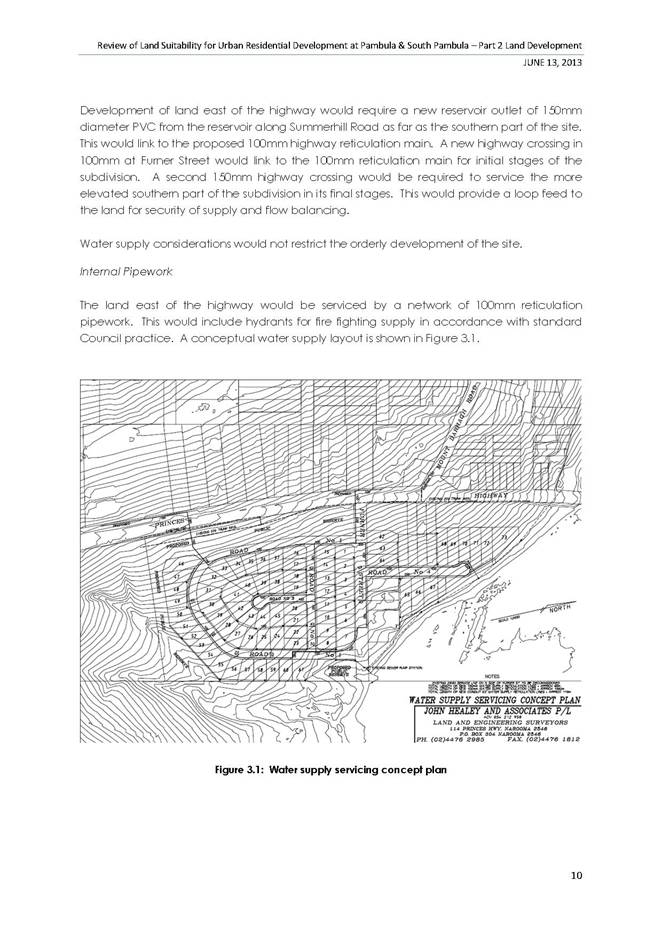
This planning proposal seeks to rezone the land as per Councils resolution to E4 Environmental Living while retaining the 1.25ha strip of land along Nethercote Road exhibited as E2 Environmental Conservation and apply a 5ha minimum lot size to the whole site.
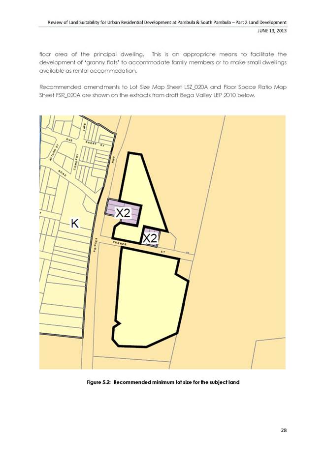
Map 1 Proposed Zones
Map 2 Proposed Lot Sizes
Description of the Changes
Changes to Zoning and Lot Sizes
|
SITE |
DESCRIPTION |
CURRENT ZONING |
EXHIBITED ZONES |
AMENDED ZONES |
EXHIBITED LOT SIZES |
AMENDED LOT SIZES |
|
1 |
LOTS 451-453 DP 747031, PART LOT 1 DP 1088971 |
1(a) |
RU2 |
E4 |
120HA |
1HA and 5HA |
|
2 |
LOT 711 DP 1128593 |
1(a) |
RU2 |
E4 and E2 |
120HA |
5HA |
Potential lot yields
|
SITE |
DESCRIPTION |
SITE AREA |
PROPOSED LOT SIZES |
LOT YEILD |
|
1 |
LOTS 451-453 DP 747031, PART LOT 1 DP 1088971 |
5 HA
4HA
12HA |
1 HA
5HA
5HA |
5 LOTS 2 LOTS EXISTING 2 ADDITIONAL LOTS |
|
2 |
LOT 711 DP 1128593 |
41 HA |
5HA |
8 LOTS |
|
TOTAL |
|
|
|
17 |
Consultation
If adopted by Council, these two sites will be placed on public exhibition following Gateway determination for the Department of Planning and Environment.
Conclusion
This report seeks the endorsement from Council officers to present this planning proposal to the Department of Planning for determination at Gateway.
The purpose of this Planning Proposal is to rezone additional rural residential land at South Pambula and adopt the recommended zoning and minimum lot sizes as detailed in this report.
Attachments
1⇩. Rural Residential Land South Pambula
|
1. That the following amendments as follows; a) SITE 1: Lots 451-453 DP 747031 Lloyd Street/Princes Highway, South Pambula
b) SITE 2: Lot 711 DP 1128593 23 Summerhill Road, Greigs Flat
2. That staff be authorised to forward this Planning Proposal for Mapping of Environmental Zone to the Department of Planning for Gateway determination in accordance with the recommendations contained within this report. 3. That following Gateway determination the Planning Proposal be placed on public exhibition and, following the exhibition period, a further report be submitted to Council for incorporation of these two sites within the Bega Valley Local Environmental Plan 2013. |
|||||||||||||||||||||||||
|
Council 13 December 2017 |
Item 9.6 |
9.6. DA No. 2016.472: Section 82A review of determination - Lot 28 DP 1107525 K B Timms Drive, Eden - 5 lot subdivision
Acting Director Planning and Environment
|
Applicant |
K Pongratz |
|
Owner |
K Pongratz |
|
Site |
Lot 28 DP 1107525 K B Timms Drive Eden |
|
Zone |
Part E2 – Environmental Conservation, Part R5 – Large Lot residential and Part R2 – Low Density Residential |
|
Site area |
45.3 ha |
|
Proposed development |
5 lot subdivision |
Precis
In accordance with Council’s Resolution of 20 September 2017, a Councillor site inspection was held on 8 November 2017.
The issues raised in the applicant’s original request for review, and those discussed during the site inspection are outlined in this report.
The applicant’s request to review specific conditions of the Consent is supported in part.
Background
Council, at its meeting dated 20 September 2017, considered a request to seek a review of specific Consent conditions relating to the subdivision of the land.
The report can be view on Council’s website:
Agenda of Council - 20 September 2017 (hold control and click on this link to view the report)
Item 9.1. DA No. 2016.472: Section 82A review of determination - Lot 28 DP 1107, 525 K B Timms Drive, Eden - 5 lot subdivision
The Council officer recommendation was:
“1. That the applicant be advised that in determining the request to seek a review of specific conditions detailed in Development Consent 2016.472 dated 16 June 2017 Council has resolved the following:
a. that Conditions 8, 13, 15 and 17 be retained without amendment for the reasons nominated within the Council report dated 20 September 2017.
2. That Council resolve on the appropriateness of Conditions 24(a) and (b) and advise the applicant accordingly.”
There was one deputation at the meeting from the applicant’s consultant and a copy of the address is included as Attachment 1 to this report.
Having considered the matter, Council resolved the following:
“That council defer the matter for an on-site visit and further report to Council.”
A site inspection with Councillors was conducted on 8 November 2017. During the inspection, issues relating to the appropriateness of Conditions 8, 15 and 24(a) and (b) were considered.
These matters are addressed further in this report.
Planning assessment
The applicant has requested a review of the following Conditions:
Condition 8
The Condition states:
“The development must be provided with underground electricity infrastructure. A Notification of Arrangement letter issued by the relevant electricity supplier is to be obtained and forwarded to the Principal Certifying Authority prior to the issue of a subdivision certificate.”
8 Comment:
The site inspection reviewed the existing above ground power supply currently available within Komirra Drive. Acknowledging that reticulated electricity is currently available, Council officers support amendment to the condition to permit overhead electricity infrastructure. It was noted that any further subdivision of land within proposed Lot E into smaller residential sized allotments would require the provision of underground electricity supply being consistent with the existing underground electricity supply located within Eden Cove.
It is recommended the Condition be amended to read:
“The development must be provided with overhead electricity infrastructure. A Notification of Arrangement letter issued by the relevant electricity supplier is to be obtained and forwarded to the Principal Certifying Authority prior to the issue of a subdivision certificate.”
Condition 13
The Condition states:
“The inner asset protection zones applying to proposed Lots A to D inclusive shall be managed in accordance with the requirements of the Eden Cove Master Plan (7-2-225) dated 19 April 2006, more specifically and as relevant, Part 4.5 of the associated Bushland Management Plan prepared by Conacher Travers dated March 2006. The plan of subdivision and Section 88B Instrument shall establish a suitable covenant to give effect to this requirement. Council is to be nominated as having the benefit of the covenant and the sole authority to release, vary or modify the covenant.”
8 Comment
The applicant at the Council meeting of 20 September 2017 confirmed the Condition has been clarified and is acceptable without change.
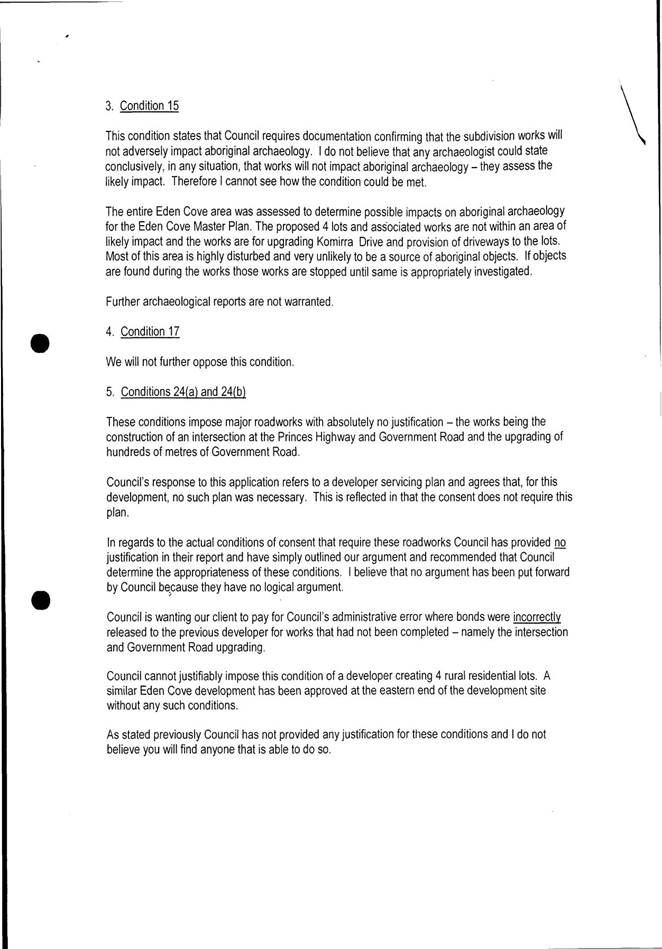
Condition 15
The Condition states:
“Prior to the issue of any subsequent subdivision certificate, documentation shall be submitted to Council confirming that any and all works associated with the subdivision will not adversely impact on the integrity of aboriginal archaeology on the subject land and/or on land in the immediate locality.”
8 Comment
Council officers maintain its recommendation reported to Council on 20 September 20017.
The Condition places the onus on the applicant to establish the scope of the subdivision works as required by the Consent and to engage a suitably experienced and/or qualified professional to evaluate any associated impacts on Aboriginal cultural and archaeological heritage. As previously reported to Council, some initial upfront investigation may save significant time if, as part of the subdivision works, Aboriginal items of cultural significance are unearthed. In such an event, all works must cease immediately and contact made with the Office of Environment and Heritage for the purpose of resolving on an appropriate course of action.
Council officers are of the opinion the Condition should not be amended.
Condition 17
The Condition states:
“Prior to the issue of the subdivision certificate, the area shown on proposed Lot D as being included in the canopy restoration area as defined by the Eden Cove Master Plan (7/2/2005) dated 19 April 2006, more specifically, the associated Bushland Management Plan prepared by Conacher Travers dated March 2006 shall be revegetated in accordance with the Plan to Council’s satisfaction. Prior to works commencing, consultation with relevant Council staff is recommended for the purpose of defining the scope of the works involved.
Alternatively, the rear boundary of proposed Lot D shall be modified to effectively excise and relocate the nominated area to within the boundaries of proposed Lot E”
8 Comment
The applicant at the Council meeting of 20 September 2017 confirmed the Condition has been clarified and is acceptable without change.
Conditions 24 (a) and (b)
Condition 24(a) states:
“The following subdivision work shall be designed (Engineering Design plans submitted to Council for approval) and constructed in conformity with Council’s Subdivision Guidelines and Technical Specifications (or other documents formally adopted by Council for the purpose of specifying standards for subdivision works as current at the date of the relevant Construction Certificate) and sound engineering practice:
Roadworks
A The subdivider shall carry out pavement strengthening improvements in Government Road to accommodate traffic loadings arising from the subdivision including the following:
● Pavement strengthening and reconstruction between Komirra Drive and Palestine Creek,
● 6.4 metre wide bitumen sealed pavement with 0.6 metre wide bitumen sealed shoulders on both sides,
● 1.5 metre wide table drains,
● Constructed stormwater drainage (minimum pipe size shall be 450mm diameter),
● Erection of road name signs, and
● Installation of guideposts, protective fencing, and signposting, to the standards specified in the Roads and Traffic Authority’s “Road Design Guide.
(Reason: to provide an appropriate standard of access to the land and to accommodate the traffic likely to be generated by this development.)”
8 Comment
Officers from Council’s the Transport and Utilities Group have considered the applicant’s position on the matter and are not supportive of the deletion of the Condition based on the semi-rural nature of the subdivision, noting the design specification is applicable to all new rural subdivisions and has been recently imposed on 4 rural lots accessing the Princes Highway at Quaama.
Council officers are of the opinion the Condition should be retained without amendment.
Condition 24(b) states:
“The intersection of Government Road with the Princes Highway shall be designed and constructed to satisfy the minimum standards for a CHR/AUL intersection treatment as set out in the Roads and Traffic Authority’s “Road Design Guide”, including the requirement for Safe Intersection Sight Distance for a 70 km/hr design speed in the Princes Highway.
(Reason: to provide an appropriate standard of access to the land and to accommodate the traffic likely to be generated by this development).”
8 Comment
Officers from Council’s Transport and Utilities Group considered the applicant's position on the matter and maintain that intersection upgrading works are required for the proposed subdivision. It is considered this could be achieved at relatively minor cost with geometric changes to the shoulder alignment, signage and line marking using the BAR/BAL standard intersection design.
However, it is to be noted that prior to the development of the residue portion (proposed Lot E) a more substantial treatment will likely be required after consultation with Roads and Maritime Services. Particularly, given the use of Palestine Road which now effectively makes the junction onto Princes Highway into a four way intersection at the bottom of a steep decline where safety is paramount. A minimum CHR/AUL treatment or roundabout would be likely design options at that time.
Council officers recommend the Condition should be amended to read:
“The intersection of Government Road with the Princes Highway shall be designed and constructed to satisfy the minimum standards for a BAR/BAL intersection treatment as set out in the Roads and Traffic Authority’s “Road Design Guide”, including the requirement for Safe Intersection Sight Distance for a 70 km/hr design speed in the Princes Highway.
(Reason: to provide an appropriate standard of access to the land and to accommodate the traffic likely to be generated by this development).”
Conclusion
In accordance with Council’s Resolution of 20 September 2017, a Councillor site inspection has been undertaken.
The request for review of Conditions have been discussed in this and it is recommended Condition 8 and 24(b) be amended as outlined with all other Conditions being retained without amendment.
Attachments
1⇩. 2016.472 Proponent's address to Council meeting 29/09/2017 item 9.1
|
1. That the request to seek a review of Conditions detailed in Development Consent 2016.472 dated 16 June 2017 be determined as follows: a. That Condition 8 be amended to read: “The development must be provided with overhead electricity infrastructure. A Notification of Arrangement letter issued by the relevant electricity supplier is to be obtained and forwarded to the Principal Certifying Authority prior to the issue of a subdivision certificate.” b. That Condition 13 is not amended. c. That Condition 15 is not amended. d. That Condition 17 is not amended. e. That Condition 24(a) is not amended. f. That Condition 24(b) is amended to read: “The intersection of Government Road with the Princes Highway shall be designed and constructed to satisfy the minimum standards for a BAR/BAL intersection treatment as set out in the Roads and Traffic Authority’s “Road Design Guide”, including the requirement for Safe Intersection Sight Distance for a 70 km/hr design speed in the Princes Highway. (Reason: to provide an appropriate standard of access to the land and to accommodate the traffic likely to be generated by this development).” 2. That the applicant be advised that prior to the future residential subdivision of the balance of the landholding (Proposed Lot E), it will be necessary to prepare in consultation with Council officers and Roads and Maritime Services, a Development Servicing Agreement that deals with, amongst other things, the intersection treatment on Princes Highway/Government Road to address safety and access concerns. |
|
Council |
13 December 2017 |
|
Item 9.6 - Attachment 1 |
2016.472 Proponent's address to Council meeting 29/09/2017 item 9.1 |
10.1 Community Project Proposals........................................................................... 181
10.2 Recreation asset insurance status..................................................................... 181
10.3 2018 Citizen of the Year and Young Citizen of the Year Awards...................... 181
|
Council 13 December 2017 |
Item 10.1 |
10.1. Community Project Proposals
This report provides a summary of community project proposals received between 1 July 2017 and 30 November 2017 for Council's information and consideration.
Director Community, Relations and Leisure
Background
The community has an important role in helping Bega Valley Shire Council (BVSC) identify and deliver new and/or improved community facilities. More often than not Council will become responsible for all works on Council managed land including compliance, maintenance, upkeep and safety. With this in mind, regardless of the project size, all works proposed for Council managed land need to be considered in the context of all project elements including: funding; personnel; procurement; risk management; work health and safety; environmental considerations; approvals; compliance; and ongoing maintenance. It is also important to consider how the proposed works can link and add value to other planned Council projects, particularly in terms of the maintenance and replacement of existing assets.
Council’s Community Project Proposal Procedure applies to all projects from small scale through to larger more complex projects. One of the aims of the procedure is to make sure all relevant project issues are considered and addressed early in project development.
The procedure involves reporting proposals to Council, particularly where projects are complex and/or will require resourcing from Council. Those proposals that are straight forward and not requesting funding from Council are reviewed and approved by Council officers. This enables groups to get on with their proposed works.
The level of information included in the proposal needs to be relevant to the scale and complexity of the project and sufficient to enable the merits and issues of proposal/s to be understood by officers and Councillors. Thorough proposals will clearly show the merit of the project, outline what is being requested and identify potential issues and how they have been addressed. The initial assessment by Council officers seeks to minimise wasted effort (or expense) on proposals that may not obtain approval due to funding, planning or other reasons.
The Community Project Proposal Procedure and the Proposal Form is available on Council's website.
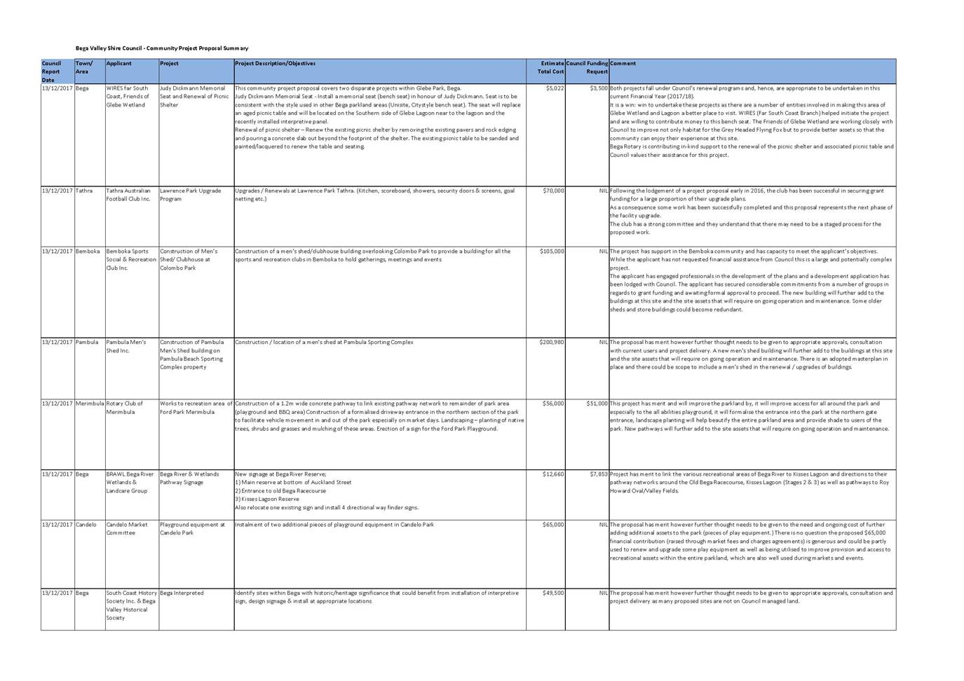
This report contains proposals received between 1 July 2017 and 30 November 2017. They are:
· Memorial Seat and Renewal of Picnic Shelter – WIRES, Friends of Glebe Wetland
· Lawrence Park Upgrade – Tathra Australian Football Club Inc.
· Construction of Men’s Shed/ Clubhouse at Colombo Park - Bemboka Sports Social and Recreation Club Inc.
· Construction of Men’s Shed at Pambula Sporting Complex – Pambula Men’s Shed Inc.
· Ford Park path and Recreation Improvements – Merimbula Rotary
· Bega River and Wetlands pathway Signage – Bega River Wetlands and Landcare Group
· Candelo Park additional playground equipment – Candelo Market Committee
· Bega Interpreted Historical signage – South Coast and Bega Valley Historical Societies
Future proposals will continue to be presented on a quarterly basis to Council for consideration and resolution.
Attached is a summary of the Project Proposals received including comments and recommendations. Hard copies of each of the full proposals received have been distributed to Councillors for their reference.
Issues
Legal /Policy
There can be legislative requirements that are triggered if the implications of works are not understood and accounted for in the project development stage. These requirements include: environment and heritage considerations; access and building code compliance; planning and development approvals; and in some instances land ownership.
Council’s Procedure 4.01.3 Community Project Proposals has been developed to manage project proposals by committees and community groups for the development and delivery of community infrastructure, civil assets and facilities.
Strategic
Community Strategic Plan 2040 - Outcomes, Goals and Strategies
|
Outcomes |
Goals |
Strategies |
|
Active and Healthy Communities |
We are an active, healthy community with access to good quality recreation and sporting facilities, and medical health care |
Improve the accessibility of the built environment, recreation spaces and facilities |
|
Collaborate with partners to provide facilities, activities and services that encourage more people to have active and healthy lifestyles. |
||
|
Liveable Places |
Our places retain their character and scale, development is well planned, and a range of goods and services are available within our Shire that meet local needs |
Improve the presentation, maintenance and physical accessibility of existing facilities and towns |
|
Provide infrastructure and services to meet the ranging needs of residents in our towns, villages and rural areas |
||
|
Strong, Consultative Leadership |
Our Council is financially sustainable and services and facilities meet community need |
Optimise value for money and deliver responsible and ethical spending and efficient service delivery across all of Council’s services |
Operational / Asset Management Plan
Relevant key directions identified in the Council’s Operational Plan are:
Community Strategic Plan goals
Goal 2: We are an active, healthy community with access to good quality recreation and sporting facilities, and medical health care.
Goal 12: Our Council is financially sustainable and services and facilities meet community need.
Operational Plan Actions 2017 - 18:
· Review the administration of the Community Project Proposal Procedure.
· Develop a Parks Volunteer Program to support and coordinate works of volunteers.
· Deliver capital works programs for parks facilities and natural areas, playgrounds and skate-parks and minor maritime assets
Council has an adopted Capital Works Program included within the asset management structure. Asset management capital works programs are based on asset renewal (e.g. replacing existing assets to meet a similar service or provision level) as determined in Council’s AMP. The large majority of projects proposed by the community relate to new works or significant upgrades of existing assets and as such are not included in capital works programs. Where projects are linked to works identified in AMP, this is clearly noted.
Social / Cultural
The community has an important role in helping Council identify and deliver new or improvement projects. Council recognises and values the important role and contribution of committees, community groups and volunteers in the management, operation and maintenance of Council infrastructure, civil assets and facilities.
Community Engagement and/or Communications
In developing the Community Project Proposal Procedure, consultation was undertaken with Council's Access Committee, the S355 Sportsground Committee and also through a workshop involving representatives of service organisations from across the Shire.
The Project Proposal form includes a section on stakeholder engagement in which the applicant can identify the consultation they have undertaken and feedback they have received in the development of their proposal.
Financial and resource considerations
The level of resourcing and contribution sought from Council is an important aspect for consideration. Council resources are limited and favouring one project over another or promotion of a project is likely to affect or defer the delivery of other planned and programed works. That is not to say contribution is not possible. This is particularly the case where the contribution is ‘good value’ and projects link to asset renewals, Strategic Plans or programed works and clearly identify inputs and contributions from project partners. This will clearly justify how the Council contribution delivers good value for requested funds. It is difficult for staff to support projects that will lead to over provision or over servicing. In these instances staff work with and provide direction to community groups to best direct effort and resources to align with Councils community strategic plan, asset management principles, and community needs.
Committees, community groups and volunteers often seek funding and grant opportunities to support their project proposal. It is important people talk with Council officers prior to applying for funding to do work on Council assets. This ensures the project scope is clear and complete, the resources identified are sufficient to complete the works and there is a level of coordination to prevent already approved projects competing with new projects for the same external Grants.
Risk
A key aspect of the Community Project Proposal Procedure and process is aimed at mitigating risk. Examples of the risk related matters that need consideration in relation to any project are:
· The costs and considerations surrounding BVSC’s ongoing management/liability.
· The costs associated with the ongoing operations and maintenance of any new asset.
· Possible shortfalls in proposal cost estimates.
· Potential expectations that BVSC will cover any potential project shortfalls.
Conclusion
The Community Project Proposal process seeks to provide a consistent framework for Council to receive and consider the wide range of projects proposed by the community. These projects can relate to new works or major upgrades and as such have not been identified in the development of capital works programs included in AMP.
The challenge is to give proposals the consideration they need and deserve and to work out where they fit with other planned and programed works. The level of resourcing and contribution sought from Council is an important consideration.
Attachments
1⇩. Community Project Proposal Summary - 1 July to 30 November 2017
|
1. That Council note the report and attached project summary. 2. That Council approve the WIRES, Friends of Glebe Wetland “Memorial Seat and Renewal of Picnic Shelter” project. 3. That Council support the Tathra Australian Football Club Inc. “Lawrence Park Upgrade” project. 4. That Council support the construction of a Men’s Shed/Clubhouse at Colombo Park by Bemboka Sports Social and Recreation Club Inc. on the basis that there is a consolidation of buildings on the site. 5. That Council support the proposal for a Men’s Shed at Pambula Sporting Complex by Pambula Men’s Shed Inc. on the basis that is consistent with the adopted masterplan for the site and planned building renewals and upgrades. 6. That Council support the proposal for “Ford Park Recreation Improvements” by Rotary Club of Merimbula on the basis that the best ‘use and value’ for asset outcome is achieved, and noting there is no Council funding allocated to the project and external funding opportunities will need to be investigated by the group. 7. That Council support the proposal for “Bega River Reserve Signage Project” by Bega River Wetlands & Landcare Group noting there is no Council funding allocated to the project and external funding opportunities will need to be investigated by the group. 8. That Council support the proposal for “Candelo Playground Equipment” by the Candelo Market Committee on the basis that it is extended to include other parkland assets on an asset renewal basis. 9. That Council support the proposal for “Bega Interpreted” by South Coast History Society Inc. & Bega Valley Historical Society noting there is no Council funding allocated to the project. |
|
Council |
13 December 2017 |
|
Item 10.1 - Attachment 1 |
Community Project Proposal Summary - 1 July to 30 November 2017 |
|
Item 10.2 |
10.2. Recreation asset insurance status
This report provides information on the insurance status of Council’s recreation assets.
Director Community, Relations and Leisure
Background
At the Council meeting 12 October 2016 in review a report (10.2) on storm damaged recreation assets Council resolved:
“5. That Council receive a report on recreation assets not currently covered by Council’s insurance.”
Council officers have reviewed Council's insurance policies and gathered further information and clarification from Council's insurer. The information is provided below.
Issues
Asset
The following recreation asset types are insured.
· Swimming Pools
· Surf clubs
· All sporting buildings and Council owned contents. Council cannot insure contents it does not own (i.e. sports equipment owned by sports clubs stored in Council facilities).
All other recreation asset types are not currently insured. This includes assets such as toilets, viewing platforms, park shelters, park furniture, playgrounds, boat ramps and pontoons.
Council cannot obtain insurance under the current policy for ‘civil’ infrastructure related items i.e. roads, footpaths, walkways, fencing, bollards and labour for cleaning up of flooded areas.
In addition, as recreation assets are typically not considered critical infrastructure, they have not been covered under the NDRRA funding stream. Council’s broad insurance policy does not cover damage caused by ‘Action of the sea’. For example, damage caused to the Wallaga Lake boardwalk and the pontoon and jetty at Quarantine Bay in the June 2016 storm, was not covered. Roads and Maritime Services (RMS) has funded Quarantine Bay jetty and pontoon repairs).
Risk
Insurance is a mechanism to manage risk. There is no doubt there is some level of risk to most recreational assets. The question is what levels or risk is acceptable and what cost of insurance cover is reasonable and affordable. There is scope to add specific assets, such as board walks, to the insurance policy. The premium to insure assets is approximately $1,500 per million dollars. Many recreational assets are of relatively low value.
Decisions on insurance cover need to be made considering the level of insurance excess that applies ($10,000 per property related claim), the likelihood, likely frequency and scale of damage, and cost of repair of damage. To determine whether insurance is of value this needs to be balanced against the cumulative cost of insuring that asset type over many years. For example, whilst Wallaga Lake boardwalk is an expensive asset to repair the cumulative cost of insuring all boardwalks over many years and the ‘action of the sea’ exclusion (being the probable cause of damage) within the insurance policy makes the value of insuring these assets questionable.
Conclusion
The report gives an overview of what recreation assets are and are not insured under Council’s current insurance policy. Noting the costs of policy cover, limitations of cover, and likelihood of incidents it is not recommended to increase the levels of insurance cover on Council’s recreation assets.
Attachments
Nil
|
That Council note the information in the report. |
|
Council 13 December 2017 |
Item 10.3 |
10.3. 2018 Citizen of the Year and Young Citizen of the Year Awards
Council has advertised for nominations for the 2018 Bega Valley Shire Citizen and Young Citizen of the Year Awards and consideration should now be given to determine awardees.
General Manager
Background
For many years Council has selected a Bega Valley Shire Citizen and Young Citizen of the Year in recognition of outstanding community service or achievement. These prestigious awards are presented as part of the Shire’s official Australia Day Ceremony on 26 January each year.
Advertisements were run over all local media outlets, on Council’s website, Council’s Facebook page and via media releases. Contact was made with local schools and other organisations to encourage submission of nominations. Nominations closed on 21 November 2017.
Nominators will receive letters acknowledging receipt of the nominations and will be advised of the process.
Copies of the nominations are provided to Councillors separately.
Issues
The Australia Day Council of NSW (ADC) forwards to Councils any unsuccessful local nominees for the Australian of the Year. Under ADC guidelines, Council may include these nominations from the national award with the local citizen awards. No nominations that qualify were received from the ADC at the time of writing this report.
Conclusion
The Bega Valley Citizen and Young Citizen of the Year Awards are an important way Council recognises individual contributions and achievements by members of the local community.
Attachments
1. Memo to Councillors Summary of Nominations received Citizen and Young Citizen of the Year 2018 (Councillor Only) (Confidential)
2. 2018 Citizen and Senior of the Year - copy of nominations received (Councillor Only) (Confidential)
3. 2018 Young Citizen of the Year copy of nominations received (Councillor Only) (Confidential)
|
1. That the matter be deferred to the Closed Session for discussion. 2. That Councillors select the Bega Valley Shire Citizen of the Year for 2018. 2. That Councillors select the Bega Valley Shire Young Citizen of the Year for 2018. 3. That the successful nominees be advised they will be presented with their awards at the Australia Day ceremony to be held in Bega on 26 January 2018, and that announcement of the awardees will be kept confidential until the official Australia Day program is released. |
Council |
13 December 2017 |
12.1 RFT 81/17 Central Waste Facility Supply and Installation of Geosynthetic Materials for Stage 3 Cell Liner and Stages 1 and 2 Cap..................................................................... 181
12.2 RFT 80/17 Central Waste Facility Stage 3 Construction and Stage 1 and 2 Capping Civil Works........................................................................................................................... 181
12.3 Section 64 Contributions Supplementary Report - Alternative Charging Mechanisms 181
12.4 Management and Operation of Merimbula Airport........................................ 181
12.5 Bega Valley Local Traffic Committee............................................................... 181
12.6 Scheduled Maintenance of Hanscomb Creek Bridge and Johnson Creek Bridge, Garfields Road, Numbugga......................................................................................................... 181
|
Council 13 December 2017 |
Item 12.1 |
12.1. RFT 81/17 Central Waste Facility Supply and Installation of Geosynthetic Materials for Stage 3 Cell Liner and Stages 1 and 2 Cap
This report details the outcomes of evaluation of Tender 81/17 for the supply and installation of geosynthetic materials for the Central Waste Facility Stage 3 cell liner, and Stages 2 and 3 capping works, and recommends award to the preferred tenderer.
Acting Director Transport and Utilities
Background
The background and issues relating to this project is largely detailed in the separate report for the civil works component of the project (RFT 80/17).
The tender was publically advertised in the Sydney Morning Herald, Council website and TenderLink on 24 October 2017 and closed on 15 November 2017. A site inspection was conducted for tenderers on 1 November 2017.
Tender submissions were received from:
· Curtis Barrier International Pty Ltd
· DDTLA Pty Ltd t/as Teneo
· Eco Line Solutions Pty Ltd
· Fabtech Australia Pty Ltd
· Jaylon Group
· LMI Group Investments Pty Ltd
· RD Miller Pty Ltd
· Waterlogic Group Pty Ltd
The tender submissions were assessed against the following evaluation criteria:
|
Evaluation Criteria |
|
|
Non-Price Criteria (40%) |
Weighting |
|
Proposed construction arrangements, including site establishments and traffic management plan |
5% |
|
Construction program |
5% |
|
Recognition of local outcomes, demonstration of support for local business and community enterprise |
5% |
|
Experience completing similar projects |
10% |
|
References |
5% |
|
Work health and safety, quality and environmental management qualifications& experience |
5% |
|
Demonstrated capacity to undertake a project of this scale |
5% |
|
Price Criteria (60%) |
Weighting |
|
Total Price |
60% |
Issues
Legal /Policy
The tender process complied with the Local Government Act 1993 and Council procedures.
Financial and resource considerations
The cost associated with the supply and installation of geosynthetic materials is within the individual amounts budgeted in the Long Term Financial Plan (LTFP). However it should be noted the Waste capital works programme is effectively being compressed into a shorter timeframe due to landfilling rates, and this effective acceleration of landfill capital expenditure represents a far more significant cost in the long term.
Conclusion
The geosynthetic lining works for Stage 3 and the capping works for Stages 1 and 2 are necessary for the effective operation of the CWF and delivery of waste services in the Shire. The tender evaluation process for the geosynthetic supply and installation works is complete and award to the preferred tenderer is recommended.
Attachments
1. Memorandum to Councillors reagarding RFT 81/17 Central Waste Facility Supply and Installation of Geosynthetic Materials for Cell 3 Liner and Stages 1 and 2 Cap (Councillor Only) (Confidential)
|
1. That Council accept the tender evaluation recommendation as outlined in the Confidential Attachment. 2. That Council accept the tender from <insert> in relation to contract for the works described in Tender RFT 81/17, in the amount of $<insert> (including GST), subject to variations and provisional sums. 3. That authority is delegated to the General Manager to execute all necessary documentation. 4. That the other tenderers be advised of Council’s decision. |
|
Council 13 December 2017 |
Item 12.2 |
12.2. RFT 80/17 Central Waste Facility Stage 3 Construction and Stage 1 and 2 Capping Civil Works
This report details the outcomes of the evaluation of Tender 80/17 for the Central Waste Facility Stage 3 cell excavation, Stages 1 and 2 capping works and recommends award to the preferred tenderer.
Acting Director Transport and Utilities
Background
The Central Waste Facility (CWF) is a landfill which has been approved to be developed in six stages. Landfill operations at the CWF commenced in December 2013 with Stage 1 of the landfill being filled to capacity in May 2016 and Stage 2 expected to reach capacity by February 2019.
The provision of engineered landfill capacity is critical to the supply of waste services to residents and businesses. Accordingly the preparation of the Stage 3 landfill cell must be complete by the end of the 2018 calendar year to ensure continuity of this service.
In addition, Stage 1 of the CWF is due to be capped and Stage 2 will be capped when it achieves capacity early in 2019.
The civil construction works for the Stage 3 cell and capping of Stages 1 and 2 have been combined in a single tender process in order to achieve efficiencies in relation to scale, design processes, quality assurance processes (including long lead times for material quality assurance processes) and Council’s project management resources. The entire project of cell construction and capping will be conducted over a period of approximately 18 months for completion by mid 2019.
The civil construction project will be coordinated with separate contracts for supply and installation of geosynthetic lining materials (RFT 81/17) and landfill gas management works.
The tender was publically advertised in the Sydney Morning Herald, Council’s website and TenderLink on 24 October 2017 and closed on 15 November 2017. A site inspection was conducted for tenderers on 31 October 2017.
Tender submissions were received from:
· Global P4P
· LMI Group Investments
· RD Miller
· J Michelin and Son
The tender submissions were assessed against the following evaluation criteria:
|
Evaluation Criteria |
|
|
Non-Price Criteria (40%) |
Weighting |
|
Proposed construction arrangements, including site establishments and traffic management plan |
5% |
|
Construction program |
5% |
|
Recognition of local outcomes, demonstration of support for local business and community enterprise |
5% |
|
Experience completing similar projects |
10% |
|
References |
5% |
|
Work health and safety, quality and environmental management qualifications& experience |
5% |
|
Price Criteria (60%) |
Weighting |
|
Total Price |
60% |
Issues
Legal /Policy
The tender process complied with the Local Government Act 1993 and Council procedures.
Strategic
Total waste to landfill has increased from approximately 19,000 tonnes in 2012 to 27,000 tonnes in 2017. The growth in waste to landfill is being driven by commercial, industrial, construction and demolition waste generation. The landfill will require replacement in approximately 2034, subject to introduction of measures to reduce rates of landfill.
Operational / Asset Management Plan
Construction of Stage 3 is scheduled in the Waste Asset Management Plan as an activity in the 2018/2019 waste capital works programme. The project is being brought forward to commence in 2017/2018 for the reasons detailed above.
The capping of Stages 1 and 2 was identified in the 2016/2017 and 2019/2020 financial years respectively. The design process for the Stage 1 cap was delayed partly due to changes in regulatory requirements for landfill caps (from earthen cap to geo-composite cap) and consequent consideration of the interaction of landfill gas infrastructure with a geomembrane barrier layer.
Consequently the capping of Stages 1 and 2 and the construction of Stage 3 will be partly financed over the 2017/2018 and 2018/2019 financial years respectively.
Financial and resource considerations
The civil works cost for the combined projects is well within the total budget estimated for the three projects and by combining the works, a short term saving is generated. However it should be noted the waste capital works programme is effectively being compressed into a shorter timeframe due to landfilling rates, and this effective acceleration of landfill capital expenditure represents a far more significant cost in the long term.
Risk
The most significant risk is failing to complete the Stage 3 cell construction by the time Stage 2 is at capacity. A 12 month construction timeframe is being allowed to manage this risk, although this timeframe is not conservative.
Conclusion
The civil construction works for Stage 3 and the capping works for Stages 1 and 2 are necessary for the effective operation of the CWF and delivery of waste services in the Shire. The tender evaluation process for the civil works is complete and award to the preferred tenderer is recommended.
Attachments
1. Memorandum to Councillors regarding RFT 80/17 Central Waste Facility Stage 3 Construction and Stage 1 and 2 Capping Civil Works (Councillor Only) (Confidential)
|
1. That Council accepts the tender evaluation recommendation as outlined in the Confidential Attachment. 2. That Council accept the tender from <insert> in relation to contract for the works described in Tender RFT 80/17, in the amount of $<insert> (including GST), subject to variations and provisional sums. 3. That authority is delegated to the General Manager to execute all necessary documentation. 4. That the other tenderers be advised of Council’s decision. |
|
Council 13 December 2017 |
Item 12.3 |
12.3. Section 64 Contributions Supplementary Report - Alternative Charging Mechanisms
At the 7 June 2017 Council meeting, a report was presented regarding options for levying Section 64 Charges.
This supplementary report is presented to provide an analysis of options and recommendation for levying of Section 64 Charges on the subdivision of land.
This report separately provides a recommendation for a simple, equitable method of levying Section 64 Charges for commercial/industrial development.
Acting Director Transport and Utilities
Background
This report presents options for levying Section 64 Charges on the subdivision of land and for commercial/industrial development and follows an initial report presented to Council on 7 June 2017 and a briefing on 27 September 2017.
Council levies Section 64 charges to fund necessary water supply and sewerage infrastructure to serve new developments. These charges are commonly referred to as ‘Section 64 Charges’, being reference to Section 64 of the Local Government Act 1993.
Function of developer charges
Developer charges serve three related functions:
1. They provide a source of funding for infrastructure required to support growth and new development;
2. They provide cost signals regarding the price of urban development and thus encourage efficient forms of development and resource utilisation; and
3. They are an integral part of the fair pricing of water related services.
Legal justification
Bega Valley Shire Council imposes monetary contributions or works requirements under Section 64 of the Local Government Act 1993 and Division 5, Part 2, Chapter 6 of the Water Management Act 2000.
Water Supply and Sewerage Section 64 Charges are levied where a planned development places additional load on water supply and/or sewerage systems as follows:
1. The erection, enlargement or extension of a building or the placing or relocating of a building on land;
2. The subdivision of land;
3. The change of use of land or of any building situated on the land.
Subdivision of Land
Current practice
Under current arrangements, Section 64 Charges are payable for subdivisions, prior to the release of the Linen Plan.
The current payment arrangements represent low financial/cost/administrative risk to Council. This is because the mechanism for collection is legally enforceable, and the revenue comes to Council at an early stage in the development process.
The background administrative processes are a significant burden, however they are minimised under the current model.
Issues with current subdivision practice
1. The upfront payment of Section 64 charges is viewed as a disincentive to subdivision development.
· The payment upfront of developer charges is anecdotally a disincentive to development in the Bega Valley Shire;
· In fact, no pattern can be determined to support this opinion as evidenced by the SGS, 2013, Bega Valley Infrastructure Costs Study, Executive Summary Page 2 attached to this report.
2. Bega Valley Shire Council Section 64 charges currently do not fully meet the cost of development to Council.
· Current Section 64 charging levels do not achieve full cost recovery for Council and constitute a pre-existing cross-subsidy of development by the existing customer base.
Deferral of Section 64 charges for subdivisions
Council already has a pre-existing cross-subsidy of development by the existing customer base.
The most feasible additional measure to encourage subdivision of land could be achieved by implementation of a payment deferral scheme. A number of Councils in NSW allow for the deferral of Section 64 charges and this was discussed in the 7 June 2017 report to Council (Item 12.1).
Two issues must be understood prior to consideration of any deferment arrangements and they are:
· The legal authorisation required for Council to levy deferred charges;
· The administrative burden of increasing complexity, now and into the future.
Deferral arrangements are complex, both legally and administratively and with this in mind specific advice was sought from Lindsay Taylor Lawyers. A copy of that advice is attached to this report and particular attention should be paid to the Summary of Advice from Paragraphs 13 to 24 and from Paragraph 71 onwards in understanding the risks associated with a deferral option. The advice has not been reproduced here due to its extent and complexity.
Legislated legal authorisation
Council currently does not have authorisation to levy a statutory charge on unpaid Developer Charges under the Water Management Act 2000 or the Local Government Act 1993.
However there is nothing stopping Council from taking security from a developer for the deferred payment of Developer Charges associated with land subdivision. Only the Development Servicing Plan (DSP) must be amended with a mechanism Council sees fit to introduce. This could be a bank guarantee, or other mechanism.
To reduce risk to the Council, it is important the obligation to pay Developer Charges ultimately attaches to, and runs with, the land being subdivided This is similar to a statutory charge on land so that, if the Developer defaults in making payment, Council can recover payment from the purchasers of lots in the subdivision when they choose to commence construction.
This mechanism recreates the historical problem experienced by Council where property owners are asked to pay costs that subdividers should ideally have paid already.
Considering complexity – financial and reputational risk
Financial
The administrative burden around managing bank guarantees, tracking payment progress, setting and applying indexation and administration fees, dealing with enquiries and research and explaining the process to developers, constitutes a significant liability for Council.
The financial burden on Council would need to be identified to take into account the administrative burden, the time-value of money and the effect of inflation. This could be fully recovered by a percentage loading on the headworks charge in the form of a three-part charge namely:
· Construction Price Index (CPI) (% loading);
· Deferment (time-value) (% loading);
· Administration (% loading).
Such that:
· CPI + Deferment + Administration = % annual interest charge
Risk
Any recovery of Section 64 subdivision charges from the purchasers of newly created lots constitutes an absolute failure of Council Policy. This situation must be avoided, noting this has occurred in the past and is an ongoing (diminishing) problem when new development triggers Section 64 charges on unsuspecting land owners. This is a current administrative burden on Council.
Complexity leads to mistakes. Any change in process or increase in complexity will result in some lost income due to error. The value of this is not quantifiable.
Section 64 Charges - Commercial and Industrial Development
Current arrangements for levying Section 64 Charges for some commercial/industrial developments are inequitable and an impediment to economic activity, particularly in the areas of tourism and retail.
The most feasible option to alleviate the burden of upfront payment of Section 64 charges is recovery through a High Consumption Charge. The High Consumption Charge would be a charge over and above present access and usage charges. The amortised charge would be calculated based for example on a 30 year average asset life, typical cost of capital (as a percentage) and indexing of Council charges (as a percentage).
The system could capture all commercial/industrial development including Complying and Exempt Development as it is based solely on usage.
On a year by year basis the High Consumption Charge could be recalculated (for everyone on the charge) using updated Developer Charges, inflation and/or equivalent increments in usage charge.
The High Consumption Charge would provide the necessary revenue for construction of essential water supply and sewerage infrastructure as Section 64 Charges presently do. However it would not be seen as a disincentive to investment and expansion. Importantly, all commercial/industrial development would be captured as the charges are based on usage. As an additional environmental benefit, demand management would be enhanced. It should be noted that the High Consumption Charge would not negate any specific works requirements called up in the Water Management Act 2000 Certificate of Compliance.
The payment of a High Consumption Charge is transferable as it moves with the usage of water. This means that Section 64 Charges would no longer be a sunk cost for commercial/industrial business that changes premises, noting entitlement exists so there is no need for transportability considerations.
Recommended Option (Subdivision and Commercial/Industrial Development)
For the reasons outlined above and detailed in the attached SGS report it is recommended no changes are warranted to the way Section 64 Charges are applied to the subdivision of land. A hybrid option is proposed as follows:
1. On subdivision, the developer pays for and is given an entitlement of 1 ET per lot (no change);
2. On approval of the first development on the site, the Development Application is assessed and Section 64 Charges levied (no change). Subject to the fulfilment of conditions, a Certificate of Compliance is issued recording the new ET entitlement accorded to the lot. The ET entitlement is recorded against the lot;
3. On subsequent commercial/industrial Development Applications the ET are assessed as they are presently assessed, but then the developer has the option of paying up front or paying the High Consumption Charge.
Where there is an existing lot that has been subject to a Development Application, it is treated as per Item 3 above.
This option would capture all development including Exempt and Complying Development as it is based solely on usage.
This option would augment Demand Management initiatives, as it would provide a trigger for industry and commerce to look at water consumption if they go over their ET limit.
On a year by year basis the Developer Charge is recalculated and included in Fees and Charges.
Advantages and Disadvantages of Recommended Option
The advantages and disadvantages of the recommended option are outlined below:
Advantages:
1. It removes up front charges that may be seen as a disincentive to the establishment of business especially small business and start-ups;
2. Taxation benefits to developer;
3. It is simple and easy to administer when established;
4. All commercial/industrial development would be captured;
5. The High Consumption Charge reflects a true user charge and provides a stronger price signal for demand management;
6. The High Consumption Charge captures excess water use;
7. There is no entitlement except for those from initial development hence the developer is not paying for something which effectively becomes an asset of the property owner;
8. When in place, Council deals with one entity only - the property owner;
9. Debt recovery action is more secure as the billings would be conducted under the LGA, as presently occurs for water and sewerage charges.
Disadvantages:
1. Property owners need to recover the High Consumption Charge from business. This is presently the case for water and sewerage charges;
2. Increased responsibility for property owners for metering, distribution and other activities within property;
3. Similar developments may have different charges apply. Developments on lots where ET entitlements exist will not be charged the High Consumption Charge. Developments where ET entitlements do not exist may be charged the High Consumption Charge. This may be seen as an inconsistency by business and property owners;
4. May create confusion for some new businesses as to what water and sewer charges may apply;
5. Six months period to implement due to amendments required to the Authority billing system;
6. There is some initial risk for Council that the recovery of previous expenditure may slow;
7. Council will need to record/resolve ET entitlements (existing and new). This is presently done with Development Applications but needs to be developed into a Procedure;
8. Developers/Property Owners may disagree with assessment of ET entitlement. This presently occurs;
9. Billing systems will require alteration.
Conclusion
There are a range of issues with the current upfront levying of Section 64 charges as they apply to commercial/industrial development. There are a limited number of practical options available to address these issues.
In conclusion it is proposed that current arrangements for levying of Section 64 to subdivision of land remain unchanged. However it is proposed that commercial/industrial developers be given the option of paying up front or paying the High Consumption Charge for the reasons outlined above.
Attachments
1. Lindsay Taylor advice dated 26 November 2016 Security Arrangements for Deferred Payment of Developer Charges (Councillor Only) (Confidential)
2⇩. Bega Valley Infrastructure Costs Study Final Report May 2013
|
Council note the above report and that: 1. Current arrangements for upfront levying of Section 64 charges to subdivision of land remain unchanged. 2. Current arrangements for upfront levying of Water and Sewerage Section 64 charges to commercial/industrial development be modified to allow for utilisation of a High Consumption Charge.
|
|
Council |
13 December 2017 |
|
Item 12.3 - Attachment 2 |
Bega Valley Infrastructure Costs Study Final Report May 2013 |
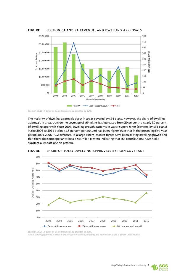
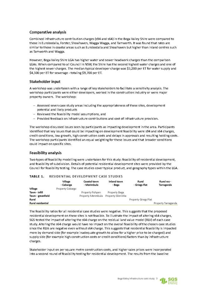
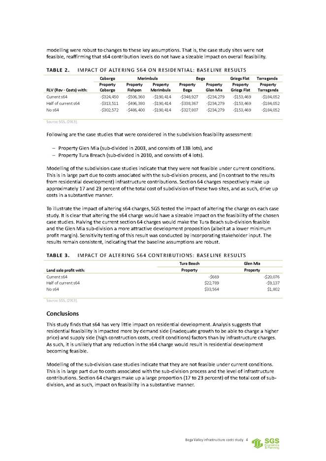
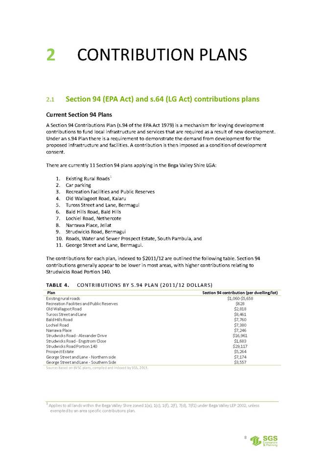
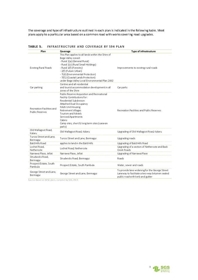
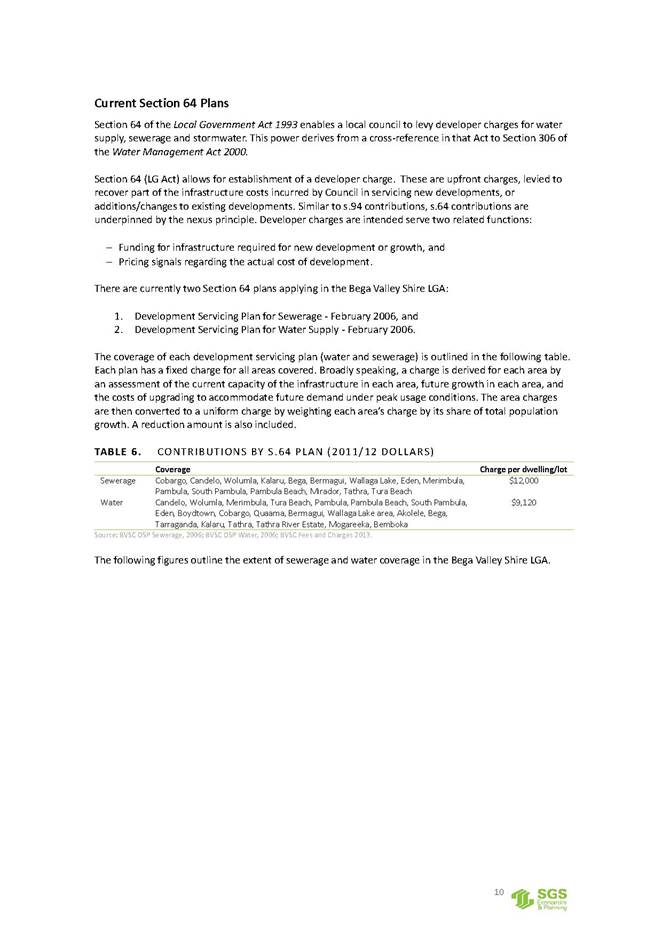
|
Council |
13 December 2017 |
|
Item 12.3 - Attachment 2 |
Bega Valley Infrastructure Costs Study Final Report May 2013 |
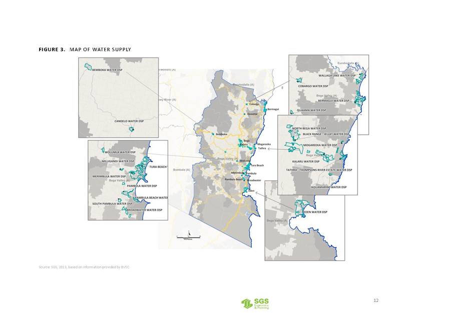
|
Council |
13 December 2017 |
|
Item 12.3 - Attachment 2 |
Bega Valley Infrastructure Costs Study Final Report May 2013 |
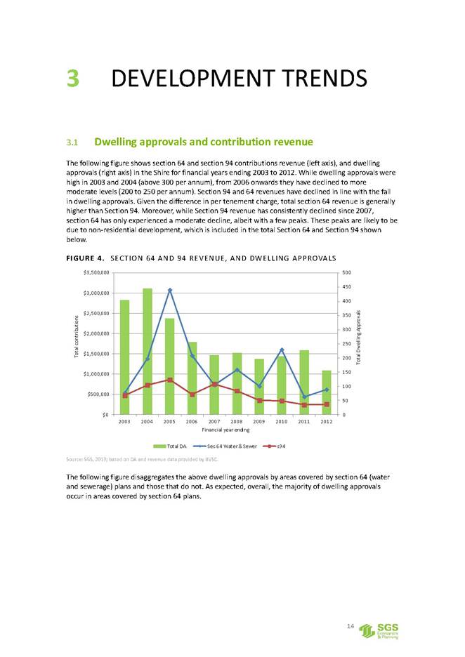
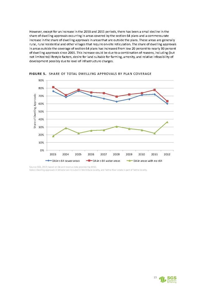
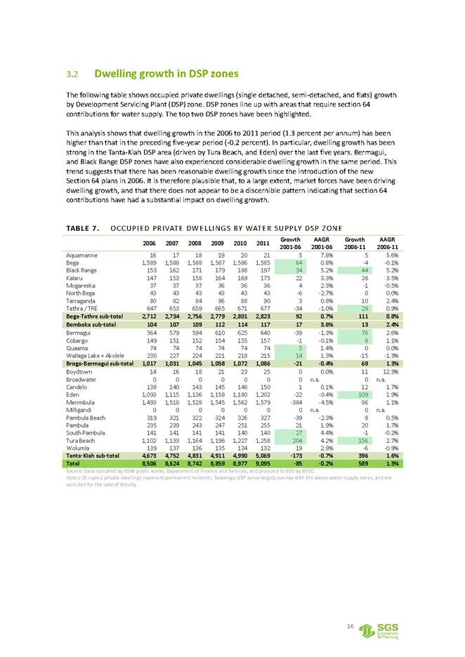
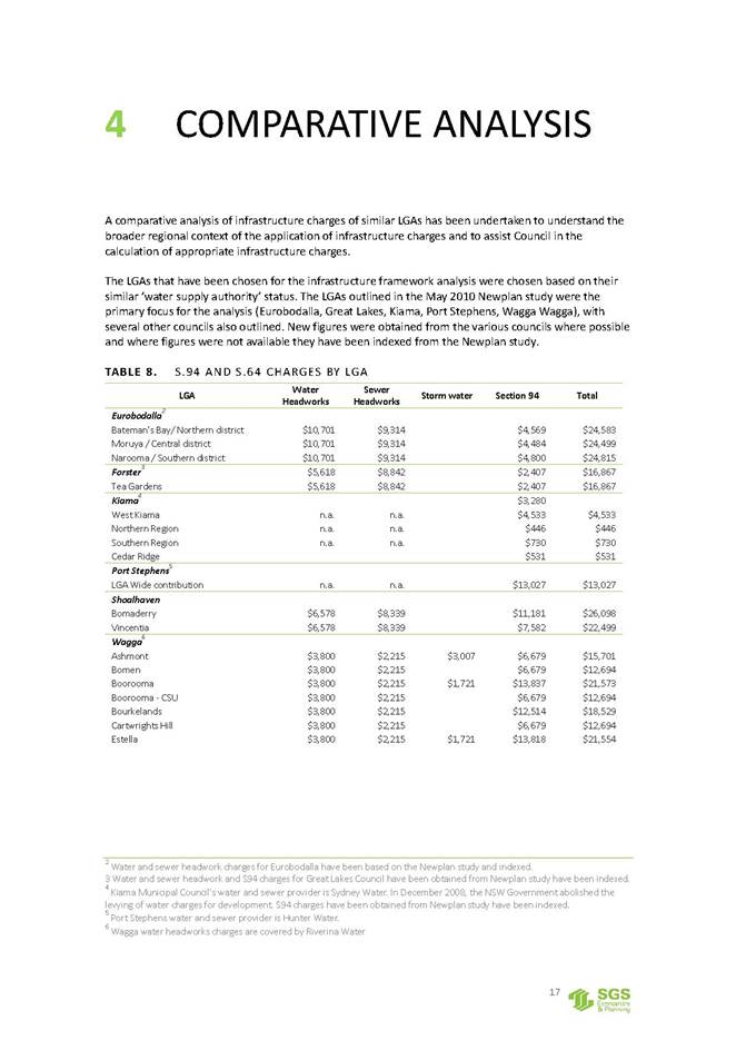
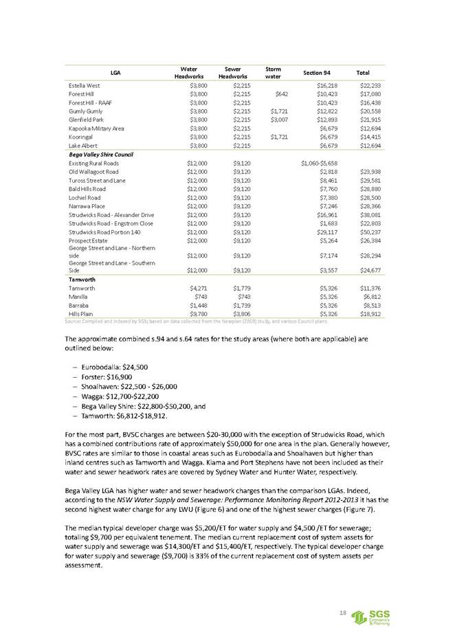
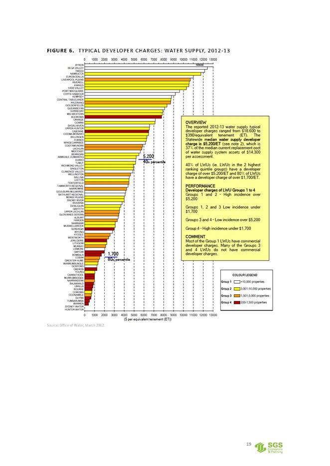
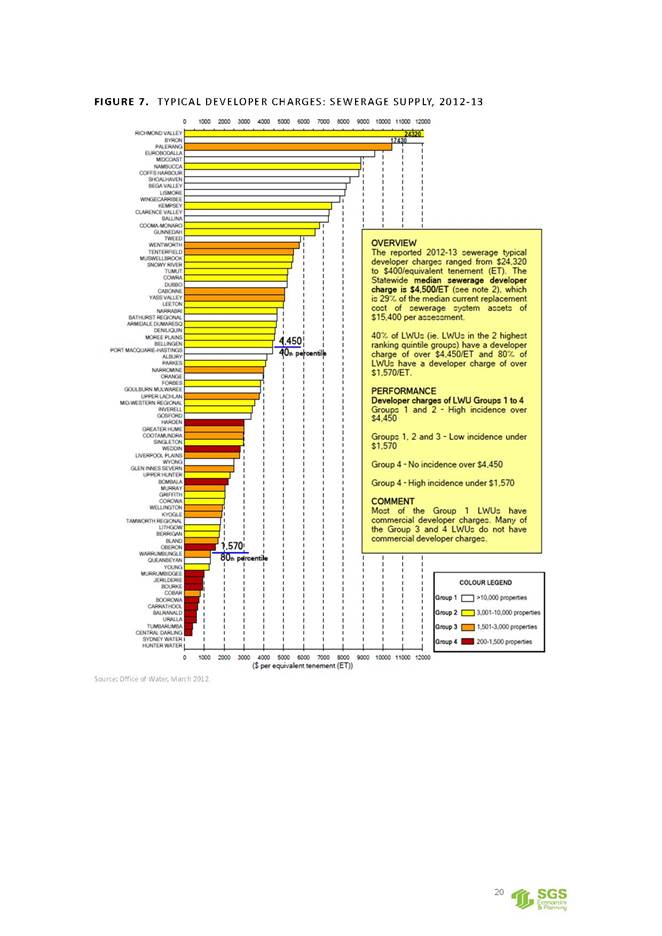
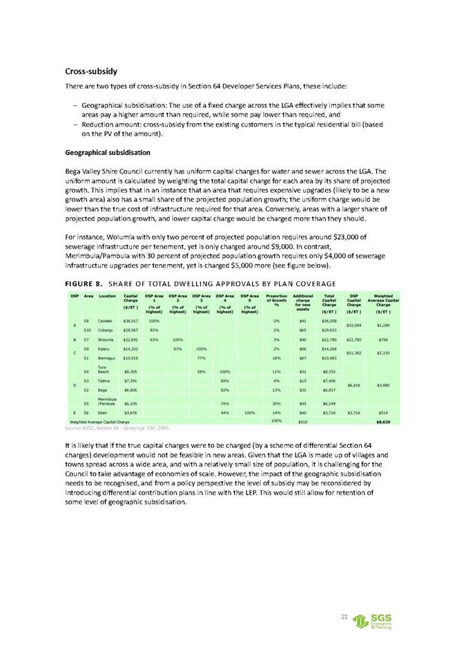
|
Council |
13 December 2017 |
|
Item 12.3 - Attachment 2 |
Bega Valley Infrastructure Costs Study Final Report May 2013 |
|
Council |
13 December 2017 |
|
Item 12.3 - Attachment 2 |
Bega Valley Infrastructure Costs Study Final Report May 2013 |
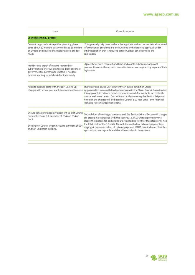
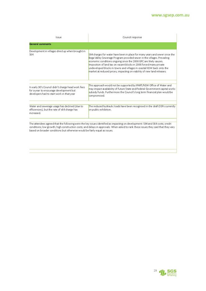
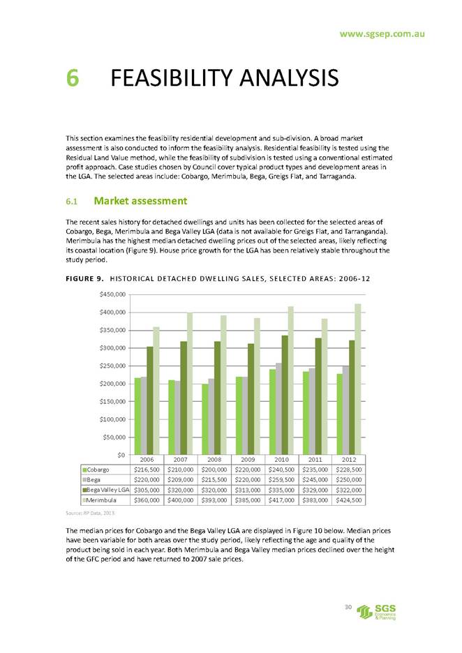
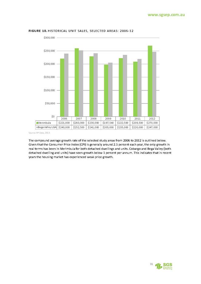
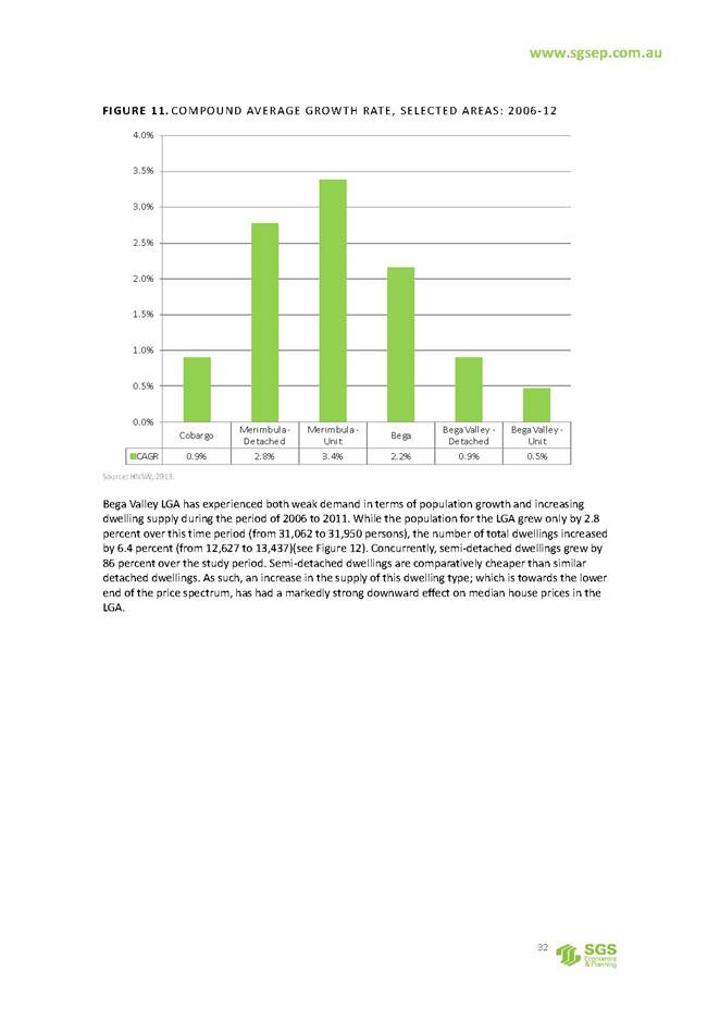
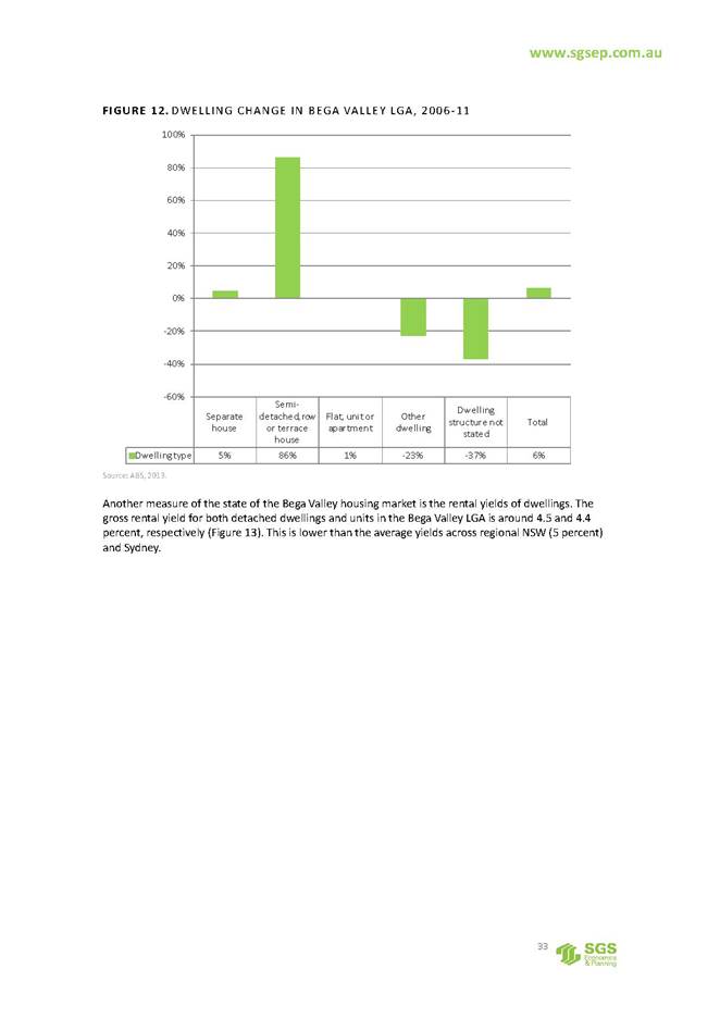
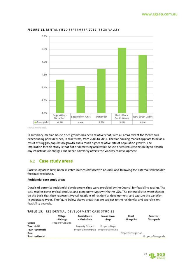
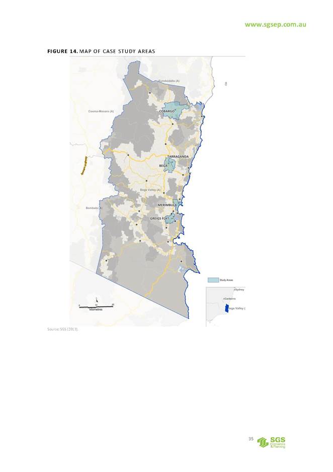
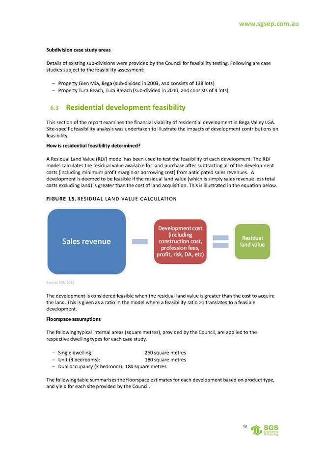
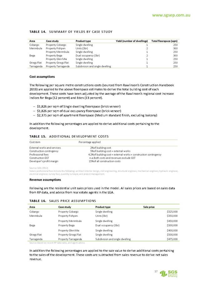
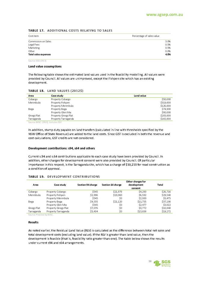
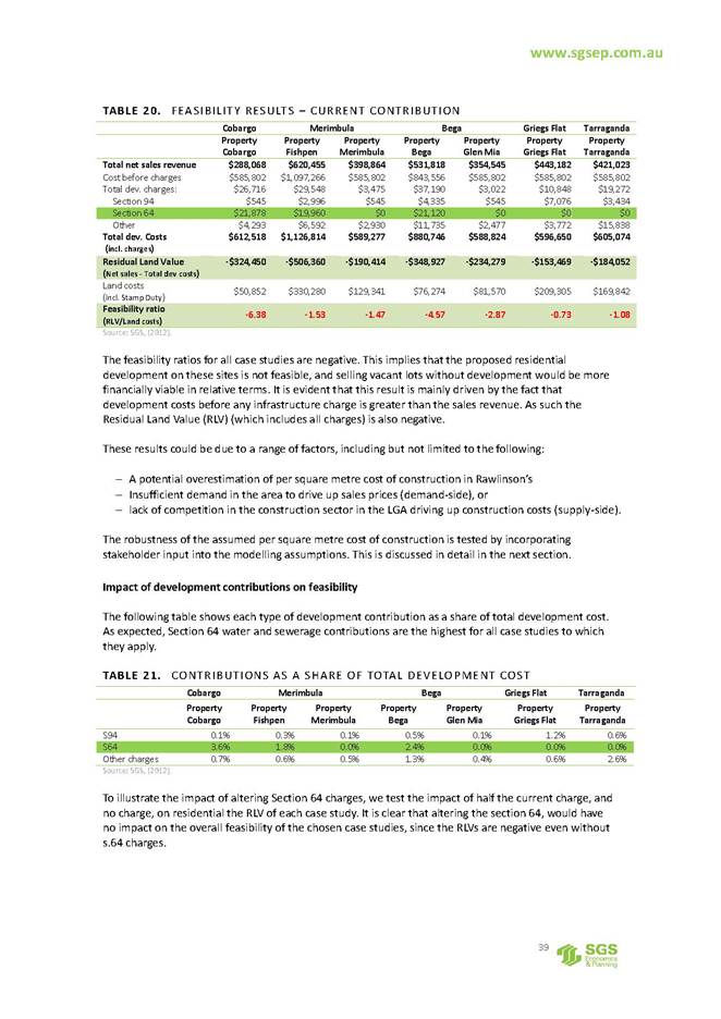
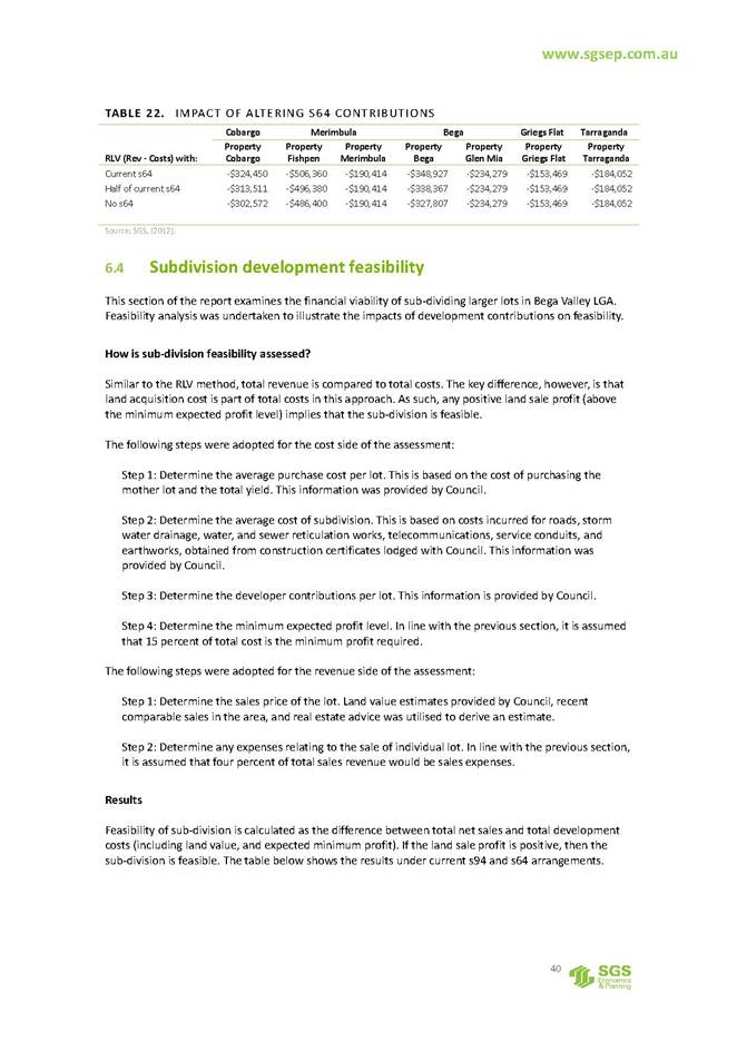
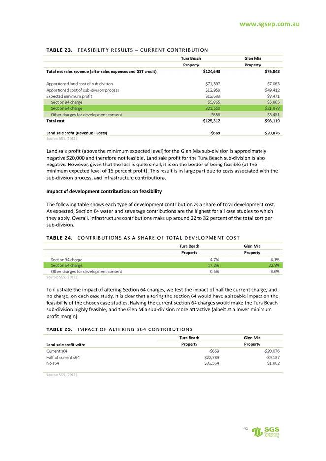
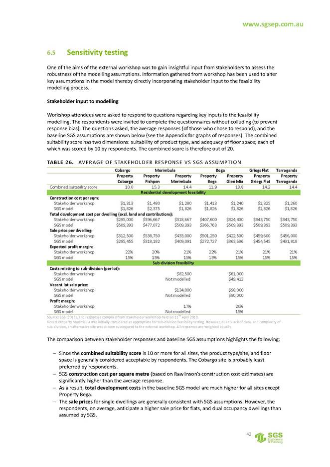
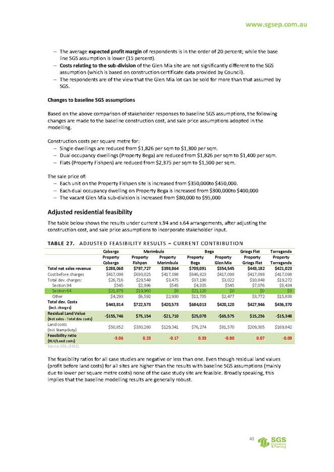
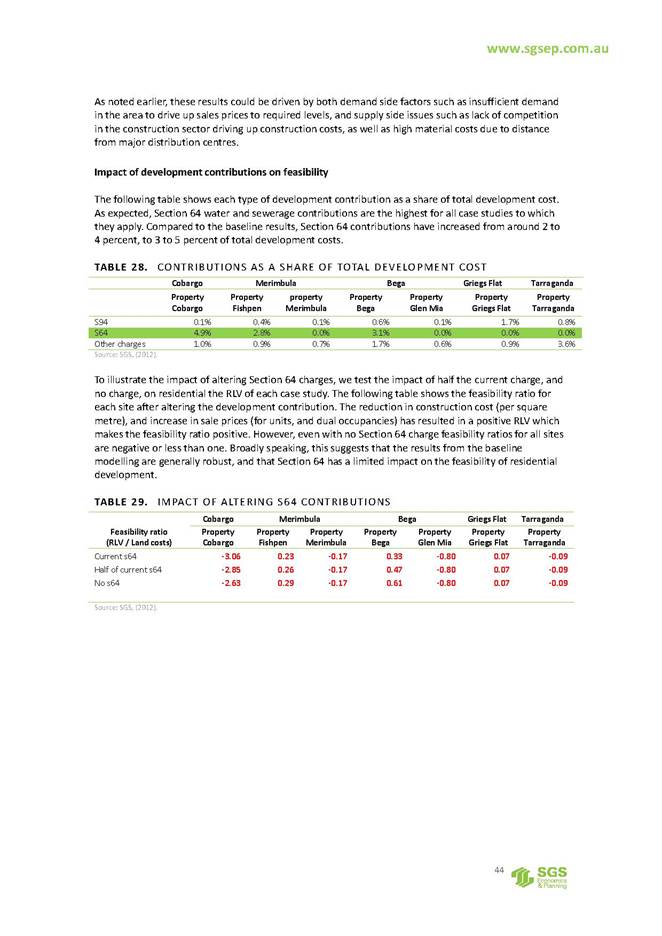
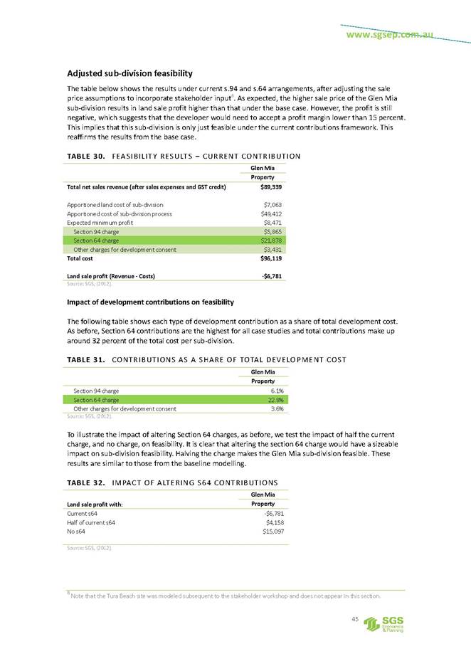
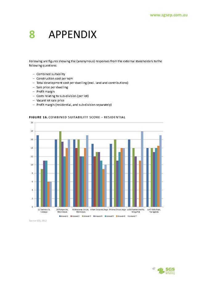
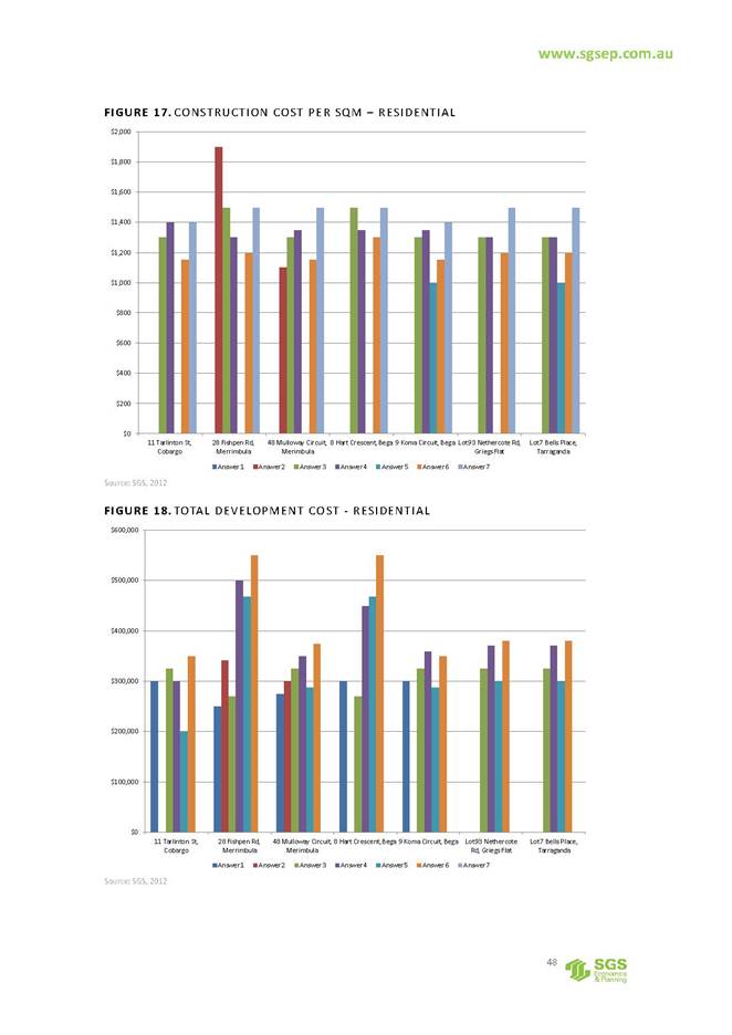
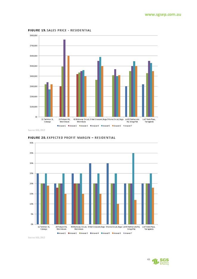
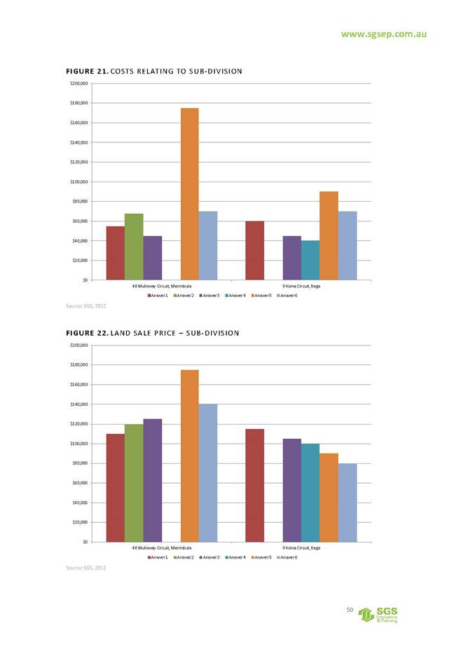
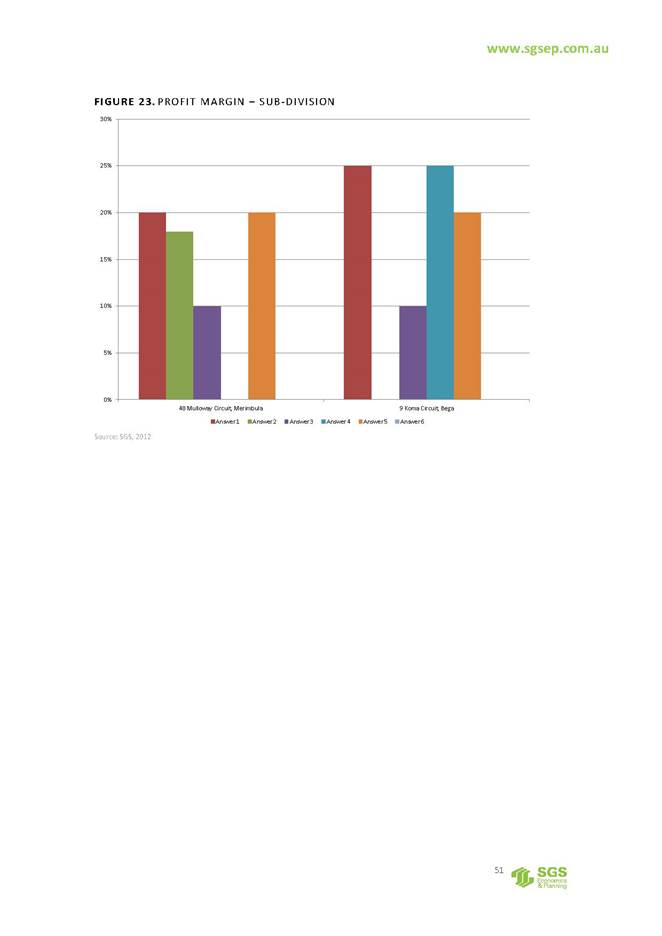
|
Council 13 December 2017 |
Item 12.4 |
12.4. Management and Operation of Merimbula Airport
This report has been prepared to update Council on the transitional arrangement for the management and operation of Merimbula Airport and to recommend that contract extension negotiations are entered into with Airport Agencies for a further two (2) years until the runway and terminal extension works are completed.
Acting Director Transport and Utilities
Background
During 2013 and 2014, a comprehensive series of Councillor Workshops, Council reports, public consultation and community debate took place regarding the future operational management of Merimbula Airport.
During this process, Council considered four basic models namely:
1. Direct Management
2. Contract Management
3. Lease Management and
4. Private Ownership
Council adopted the following Resolution on 4 February 2015:
1. That Council resolve to call for Expressions of Interest from interested bodies to enter into an appropriate, legally binding instrument for the air services operations of the Merimbula Airport with the objective of providing the maximum benefit to the community of the Bega Valley.
2. That the statement of council requirements dated 30 January 2015 be adapted to inform the Expressions of Interest.
Expression of Interest EOI 31/15 was publicly advertised and three formal submissions were assessed and considered by Council at its meeting of 22 July 2015, resolving as follows:
1. That Council invite Airport Agencies Pty Ltd, IAS Airports Pty Ltd and Ambidji Group Pty Ltd to submit tenders in relation to the management and operation of Merimbula Airport.
2. That the tender documentation and tender evaluation plan be commissioned by the General Manager from an independent body and cover operation and management options.
3. That the General Manager be authorised to appoint an independent tender assessment panel to assess tenders under the Local Government (General) Regulation 2005 and report to her at the conclusion of the evaluation process
Council at its meeting of 16 December 2015, considered RFT 31/15 Management and Operation of Merimbula Airport and resolved as follows:
1. That Council not accept any tenders as no tenders received offered value for money.
2. That Council not recall tenders as this is unlikely to provide a better outcome at this time.
3. That Council negotiate a management fee for service contract with the current operator for a 2 year transition period to allow Council to become the certified aerodrome operator for the purposes of the Civil Aviation Safety Regulations and the Aviation Transport Security Regulations.
4. That Council retender the management operations of the Merimbula Airport once operator certification has been received.
5. That the General Manager and Group Manager Transport and Utilities negotiate with the current operator and report back to Council.
Negotiations were entered into with Airport Agencies for a fixed term transitional arrangement, and Council at its meeting of 18th May 2016 resolved as follows;
1. That Council accept the submission from Airport Agencies for the Contract for Services for the management of Merimbula Airport for two years in accordance with contract documentation RFT 48/16, in the amount of $318,400 per year (excluding GST), subject to variations, provisional sums and indexation.
2. That authority is delegated to the General Manager to execute all necessary documentation.
In October 2016 Council obtained NSW State Government funding of $4,391,040 under the Restart NSW – Regional Tourism Infrastructure Program, with the key deliverable of extending the runway so that it is fully compliant for maximum take-off weight for ATR 72 and Q400 aircraft.
The fixed term transitional arrangement with Airport Agencies for the Management and Operation of Merimbula Airport commenced on the 1 July 2016 and is due to expire on the 1 July 2018.
Council received a further funding grant in July 2017 of $1,201,968 from the Federal Government under the Community Development Grants (CDG) programme to be matched by BVSC funding of $1,200,000 with the key deliverables of:
1. Construction of Departure Terminal of at least 70sqm comprising:
· Secure luggage holding of at least 50sqm;
· Installation of at least one set of scanning plant and at least one associated luggage handling plant;
· Temporary storage area for outbound luggage after screening;
· Installation of a least one set of scanning plant for carry-on luggage;
· Installation of at least one set of explosives detection plant for carry-on luggage;
· Installation of seating for at least 50 people
2. Construction of arrival terminal of a least 40sqm comprising:
· Passenger lounge for at least 10 people;
· Inbound luggage arrival area;
· Inbound air freight handling service area; and
· Tourism interpretation centre.
3. Expansion of existing carpark to accommodate at least 70 vehicles
A key element of the transitional arrangement was Airport Agencies assisting Council to become the certified operator and have in place all regulatory documentation when Airport Agencies’ involvement will end in July 2018.
In order for Council to become the certified operator, both the Master Security Licence and Civil Aviation Safety Authority (CASA) certification will be required to be transferred to Council and is dependent upon working with external agencies for this to occur.
Airport Agencies is the current airport operator with 19 years of demonstrated experience operating Merimbula Airport. The company has a satisfactory track record both financially and meeting regulatory compliance.
The experience, qualifications of Airport Agencies' key staff and their demonstrated capability shows they are able to undertake the requirements of the existing contract; in addition they have an established professional working relationship with CASA.
Airport Agencies is the entity licenced by CASA to operate the airport, as such must be included in all negotiations with CASA regarding the runway design and has been a member of the project team during the planning and design phase.
Airport Agencies have assisted Council to work through the safety regulations of civil air operations in Australia and have provided technical advice to assist in negotiations with CASA for the approval of the runway extension.
During the construction phase when the runway construction works are underway, Airport Agencies’ understanding of the existing operations and their ability to work with the current airlines and CASA will be invaluable to the delivery phase where the Management and Operation of Merimbula Airport will need to be flexible to adapt to the challenges of constructing in a live environment, in order to maintain the current air services for the community and region as a whole.
There is the ability for a tender process to apply for the ongoing Management and Operation of Merimbula Airport but due to the current circumstances as detailed above, it is seen that continuity of the current operator, utilising the existing terms and conditions of the current contract RFT 48/16, provides the optimal and least risky option for the Management and Operation of Merimbula Airport to Council, until the completion of the airport runway and terminal.
Issues
Legal /Policy
CASA is the key Statutory Authority that conducts the safety regulation of civil air operations in Australia, including the regulation of certified and registered aerodromes.
The Aviation Transport Security Act 2004 and associated Aviation Transport Security Regulations 2005, establishes a regulatory regime to safeguard against unlawful interference with aviation.
Council Resolution on 4 February 2015 regarding the operation of the airport created the current policy position on the ownership and/or operation of the Airport.
Strategic
The Merimbula Airport Master Plan is the major strategic driver for the Airport and is in the process of being updated to take into account the terminal and runway expansion projects. The Airport is a critical element of Council’s transport strategic direction and its management into the future will be critical to ensure the best outcomes for the community.
Within Council’s Community Strategic Plan (CSP) the importance of the Airport directly relates to the priorities listed through support of the local economy and the tourism industry and as part of an integrated transport network and support of emergency services.
Indirectly the operations of the airport provide access to specialist medical and educational services.
Operational / Asset Management Plan
Maintaining and operating the Airport is consistent with Council’s Operational Plan, as part of its integrated transport network.
Council adopted an Asset Management Plan for Merimbula Airport in June 2017 with the Airport infrastructure being a significant and capital intensive asset. The ongoing maintenance, renewal and upgrade of the Airport are vital for a safe, secure and reliable aviation operation. To this end, there is a need for substantial commitment of resources, particularly capital funding, over a long period of time.
Environmental / Sustainability
Merimbula Airport is located in an environmentally sensitive area, between Merimbula Lake to the west and bushland areas to the east of Arthur Kaine Drive, where extensive foreshore dunes form part of Merimbula Beach.
There are also wetland areas to the south, south west and east of the runway and within the Airport site itself. These areas are environmentally significant wetlands and are identified in SEPP14 and are a key constraint on the master planning of the site which is impacting on the runway and terminal design at the current time.
Social / Cultural
Community benefit is arguably the main reason why Council owns and operates an airport. Airport operations are seen as a vital component of an overall integrated transport network, which links the Bega Valley with capital cities. The Airport provides essential links for professional, legal, specialist and medical services as well as passengers for tourism, employment and business.
Economic
The economy of the Bega Valley has been traditionally dominated by primary industry including agriculture, forestry and fishing. While these industries are still significant, a number of other key sectors have developed, in particular tourism and remote area employment. There is growing momentum for projects linking air freight from the area. The Airport, as part of the regional/national transport network, provides access to business markets and thereby significant support to the local economy and at the same time airport operations generate a direct economic benefit.
Financial and resource considerations
The current budget provides a contract management allocation for the Merimbula Airport, based on forecast revenues from property leases, aircraft landing fees and RPT passenger levy.
The extent to which Council resources are required are dictated through management of the service contract, ongoing administration, management and financial oversight.
Conclusion
This report provides information about the background and basis of negotiations with Airport Agencies for extension of the existing transition arrangement of the operational management of Merimbula Airport.
It is recommended that negotiations are entered into and based on the existing terms and conditions of the current contract documentation RFT 48/16 to extend for a further two (2) years until the runway and terminal extension works are completed.
Attachments
Nil
|
1. That Council accept the conclusions and information as outlined in the report. 2. That Council enter into negotiations to extend the existing Contract for Services for the management of Merimbula Airport for an additional two (2) years in accordance with existing contract documentation RFT 48/16 with Airport Agencies. 3. That authority is delegated to the General Manager to enter into negotiations with Airport Agencies and to execute all necessary documentation. |
|
Council 13 December 2017 |
Item 12.5 |
12.5. Bega Valley Local Traffic Committee
This report recommends Council adopt the recommendations of the Bega Valley Local Traffic Committee from their meeting held on 1 November 2017.
Acting Director Transport and Utilities
Background
The Bega Valley Local Traffic Committee is not a Committee of Council. Local Traffic Committees operate under delegation from NSW Roads and Maritime Services who are responsible for traffic control on all New South Wales roads.
The Bega Valley Local Traffic Committee held a meeting on 1 November 2017, the minutes of which have been distributed separately. It is a requirement for Council to formally adopt the recommendations from this Committee prior to action being taken. The recommendations were supported unanimously by the Committee.
Attachments
Nil
|
Sapphire Coast Drive Parking, Merimbula. 1. That Council approve the removal of the time restricted 2 hour parking zone on the Eastern side of Sapphire Coast Drive between intersection of Main Street and Merimbula Drive, Merimbula for a trial basis during the construction phase of the supermarket in Main Street. Lamont Street Traffic Blister, Bermagui. 1. That Council reply in writing to Bermagui Area Chamber of Commerce and Tourism Inc. with the reasons the traffic blister project was initiated and the issues addressed with this construction. To be included in this letter is the width of the road with the traffic blister in place. 2. That this community sub-group’s view is raised at the Access Committee. Loading Zone, Market Street, Merimbula 1. That Council approve the removal of the existing loading zone on Market St, south-bound traffic, north side of intersection (in front of Promenade). 2. That Council approve the installation of ‘No Stopping’ signs on Market St, south-bound traffic, north side of intersection (in front of Promenade). 3. That Council contact the Merimbula Chamber of Commerce to notify them of this decision. Remove 1P Parking Space, Park Street, Merimbula 1. That Council keep the parking spot as is and to monitor the effect on the merging traffic. 2018 Far South Coast National Show 1. That, subject to conditions, the section of roadway adjoining the Bega Showground between East Street and Tathra Road, Bega be temporarily closed from 9am to 5pm on 17, 18 and 19 February 2018 for the Far South Coast National Show. 2. That, subject to conditions, Park Lane and East Street, Bega, between the intersections of Parker Street and Belmore Street be temporarily changed to one-way traffic flow eastbound / southbound from 9am to 5pm on 17, 18 and 19 February 2018 for the Far South Coast National Show. 3. That the proposed traffic arrangements for the Far South Coast National Show be deemed a Class 2 special event and it be conducted under an approved Traffic Control Plan, in accordance with the Roads and Maritime Services (RMS) Traffic Control Manual. 4. That persons involved in the preparation and implementation of the Traffic Control Plan must hold the appropriate RMS accreditation. 5. That organisers fully implement an approved Special Event Transport Management Plan. 6. That organisers have approved public liability insurance of at least $20 million indemnifying Council, Police and Roads and Maritime Services by name for the event. 7. That organisers have written Police approval prior to conducting the event. Bermagui Seaside Fair – 10th March 2018 1. That, subject to conditions, Scenic Drive, Bermagui from Endeavour Point Headland will be temporarily closed from 9:30am to 11.30am on Saturday 10 March 2018 for the Bermagui Seaside Fair street parade. 2. That, subject to conditions, Lamont Street, Bermagui between the intersections of Montague Street and Wallaga Street, be temporarily closed from 9:30am to 11.30am on Saturday 10 March 2018 for the Bermagui Seaside Fair street parade. 3. That the proposed traffic arrangements involving the temporary closure of Scenic Drive and Lamont Street, Bermagui for the Bermagui Seaside Fair street parade on Saturday, 10 March 2018, be deemed a Class 2 special event and it be conducted under an approved Traffic Control Plan, in accordance with the Roads and Maritime Services (RMS) Traffic Control Manual. 4 That persons involved in the preparation and implementation of the Traffic Control Plan must hold the appropriate RMS accreditation. 5. That organisers fully implement an approved Special Event Transport Management Plan. 6. That organisers have approved public liability insurance of at least $20 million indemnifying Council, Police and Roads and Maritime Services by name for the event. 7. That organisers have written Police approval prior to conducting the event. Bar Beach Proposed Access restriction, Merimbula 1. That Council approve the installation of R6-248 signage at the car park entrance on Bar Beach Road, Merimbula prohibiting vehicles over 7.5 metres from the Bar Beach car park, service vehicles excepted. Bermagui-Cobargo Intersection with Wallaga Lake Road 1. That Council approve the replacement of the give way sign at the Bermagui-Cobargo and Wallaga Lake Road be changed with a stop sign during the minor upgrades. Parking at Pambula Beach Road, Pambula Beach 1. That Council inform the Lumen Christi Catholic College Principal that the Local Traffic Committee reviewed the need for the ‘No Stopping’ signs on Pambula Beach Road and have not changed their position on this matter. Accordingly, the signs will not be removed. 2. That Council inform the Lumen Christi Catholic College Principal in writing of the above reasons for this decision. |
|
Council 13 December 2017 |
Item 12.6 |
12.6. Scheduled Maintenance of Hanscomb Creek Bridge and Johnson Creek Bridge, Garfields Road, Numbugga
In 2018, Council is scheduled to undertake significant maintenance on Johnson Creek and Hanscomb Creek Bridges located on Garfield Road, Numbugga, with a combined budget allocation of $300,000. This report outlines issues with budget allocation, land tenure, and low traffic volumes. It is prudent for Council to review these maintenance projects in light of the issues outlined below and consider the three options presented.
Acting Director Transport and Utilities
Background
Major maintenance and repairs to Johnson Creek Bridge and Hanscomb Creek Bridge are currently funded and programed for 2018.
Sections of the Garfield Road formation are located on private property and are not contained within a road reserve. These boundary alignments date from the late 1800s to the early 1900s and bear little relationship to the existing location of the road and bridge infrastructure within current property boundaries.
This prompted Council officers to check old plans and survey documents and it was identified that, of the two bridges, only Johnson Creek Bridge is entirely in the road reserve. The bridge is shown on the road survey plan R10939.1603, however, a boundary definition survey by a registered surveyor would be required confirm these findings. The Johnson Creek Bridge provides access to two properties (highlighted in red and blue outline in Attachment 4) that can also be accessed via the Snowy Mountains Highway and the eastern section of Garfield Road. The Hanscomb Creek Bridge approaches are not within a road reserve and the bridge itself is located wholly upon private land, this being Lot 7 DP 819196.
Council is now asked to review the risks and benefits of the scheduled maintenance and repairs to Johnson Creek Bridge and Hanscomb Creek Bridge programed for 2018. Council officers have listed three possible options that are available to resolve the issues presented in this report.
Issues
Legal /Policy
Council is required to determine the course of action for the two bridge upgrade projects on Garfield Road. Council puts itself at risk under the Civil Liability Act 2002 if no action is taken.
Strategic
The formation of Garfield Road poses no impact to the Community Strategic Plan.
Operational / Asset Management Plan
On 26 July 2017, Council undertook traffic counts at both the east and west ends of Garfield Road over a seven day period. The result revealed approximately 10 vehicles a day using Garfield Road. It is anticipated that this figure would not change significantly with any adjustment for seasonal variation.
Economic
Lifecycle costing needs to be taken into consideration when deciding on the best option. Lifecycle costs for keeping and upgrading the two bridges on Garfield Road include the yearly maintenance grade of the road (Approx. $2,000 per year) and the ongoing bridge repair and maintenance costs.
Community Engagement and/or Communications
There has been no community engagement undertaken at this time.
Financial and resource considerations
A budget of $300,000 has been allocated for the scheduled repair works on the two bridges on Garfield Road.
|
Funding source |
|
Amount |
|
10100.4000.2301 BRIDGES ON UNSEALED RURAL ROADS - LOCAL SV - Timber Bridge Rehabilitation ($128,000) |
$ |
300,000
|
Risk
Both the Johnson Creek and Hanscomb Creek Bridges generate risk for Council in that:
1. Both timber bridges are in need of significant maintenance repair work; and
2. Hanscomb Creek Bridge is located on private property with no formal tenure arrangement in place to protect the asset. If the issue around tenure is unresolved, Council may be at risk of public liability action from the land owner if an incident were to occur.
Options
Council has been presented with three possible options for consideration in the attached Confidential Memorandum.
Conclusion
The current required works sees Council spend a considerable budget allocation for maintenance of both bridges on what is a low traffic volume road with minimal impact socially and strategically.
Attachments
1. Confidential attachment scheduled maintenance of hanscomb creek bridge and johnson creek bridge garfield road numbugga memorandum to councillors (Councillor Only) (Confidential)
2⇩. Plan of lands to be resumed under the Public Roads Act 1902 in connection with the proposed deviation of the road from Bemboka to Bega through portions 27, 23, 22, 21, 28, 74, 57, 58
3⇩. Map of Hanscomb Creek Bridge, Johnson Creek Bridge and Garfields Road locations
4⇩. Map of Garfields Road and Private Property Boundaries
5. Map of Option 2 - Garfields Road Bridges Report (Councillor Only) (Confidential)
|
That Council defer to the Closed Session for discussion. |
|
Council |
13 December 2017 |
|
Item 12.6 - Attachment 2 |
Plan of lands to be resumed under the Public Roads Act 1902 in connection with the proposed deviation of the road from Bemboka to Bega through portions 27, 23, 22, 21, 28, 74, 57, 58 |
|
13 December 2017 |
|
|
Item 12.6 - Attachment 3 |
Map of Hanscomb Creek Bridge, Johnson Creek Bridge and Garfields Road locations |
|
13 December 2017 |
|
|
Item 12.6 - Attachment 4 |
Map of Garfields Road and Private Property Boundaries |
Council |
13 December 2017 |
13.1 Appointment of Delegates to attend Conferences 2017/18 and Councillor development program 2018................................................................................................................... 181
13.2 Asset review - setting the framework for 2018/19 and into the refocus of the long term financial plan.................................................................................................................... 181
|
Council 13 December 2017 |
Item 13.1 |
13.1. Appointment of Delegates to attend Conferences 2017/18 and Councillor development program 2018
This report outlines the proposed Councillor Development Program for 2018 and conference attendance January to June period of the 2017/2018 year
General Manager
Background
Councillors are afforded the opportunity for training and development through consultation with the General Manager. Changes to the Local Government Act 1993 are now in place which will mandate development of a continuing professional development plan for Councillors. Final guidelines are yet to be released. Good governance practice supports ongoing, professional development as critical to improving organisational and governance performance.
Training and development opportunities, as well as attendance at seminars and conferences are required to be reported to Council and for Council to resolve which Councillors will attend as Council’s representatives.
It has been identified that establishing a Councillor delegate appointments list for the full year in advance, enables adequate planning and access to the best rates for registration, accommodation and travel where appropriate for Councillors. Other conferences/forum related opportunities which may arise during the year that have not been identified in this report, can be reported to Council on a case by case basis.
Councillor Development Program
A full Induction Program was undertaken with Councillors following the September 2016 Local Government Election concluding in June 2017. Councillors were provided the opportunity to complete a survey and provide their comments and rankings into the knowledge gained from the induction sessions and suggestions for future sessions to assist them continue to develop and improve their skills and knowledge.
Councillors were also provided with the opportunity to complete an Individual Training Program questionnaire to identify individual training opportunities they thought appropriate to increase their knowledge and skills. Five Councillors have responded to this questionnaire and over the past month, have met with the Executive Manager Organisational Development and Governance to discuss and agree on their individual training program to be delivered over the next 3 to 6 months. These training programs/sessions include both in house delivered sessions and externally delivered programs run by Local Government NSW.
Councillors will continue to attend briefings on a weekly/fortnightly basis where a range of background information will be provided to them.
Councillor Delegate and Representatives Appointments
At the Council Meeting on 12 October, 2016, the delegates and representatives for Council Committees and Panels were resolved for the period until September 2018
At the Council Meeting on 28 June 2017, Councillors resolved on attendance at Conferences and forums until December, 2017.
The following conferences/forums have been identified as being of interest to delegates and the appropriate delegates or listed Councillors could be nominated to attend for the period January to June 2018:
|
Date & Location |
Program |
Attendees |
Status |
|
TBA-tentatively March 2018 |
LG NSW Tourism Conference, TBA |
Recommend SCT delegate currently Cr Bain |
|
|
TBA-tentatively 15 to 17 March 2018
|
Australian Local Government Women’s Association Gundagai |
Open to female councillors |
|
|
21 to 23 March 2018 Geelong |
2018 Australian Coastal Councils Conference, |
Council is a member of this group and Cr Griff is the nominated Councillor |
|
|
TBA-tentatively May 2018
|
NSW Local Government Women’s Association Venue to be advised |
Open to female councillors |
|
|
TBA June 2018
|
Australian Local Government Association National General Assembly Canberra |
Mayor and Councillors to be nominated |
|
|
TBA June 2018
|
Australian Local Government Association National General Assembly Canberra – Refugee Welcome Forum |
Mayor and Councillors to be nominated |
|
Financial
The 2017/18 Budget provides for $48,000 for elected officials training, development ($18,000 or $2,000 per Councillor) and conference attendance ($30,000). This covers Councillor Professional Development and delegate’s expenses (for attending conferences/forums and meetings in their role as Councillors).
This budget amount will include any costs for Councillors attendance at meetings as committee delegates, as resolved following on October 2016 “Committee and Panel - Delegates and Representatives”.
Conclusion
Attendance at key local government and topic specific conferences/forums are an important part of developing Councillor's skills, knowledge and contacts. Councillors should aim to continually improve their understanding of emerging trends, issues, challenges and opportunities that may now, and into the future affect, the Bega Valley Shire Council and community.
Attachments
Nil
|
1. That Council note the Councillor Delegates Program for January to June 2018. 2. That Council agree the number of delegates to represent Council at the nominated conferences/forums (insert names):
|
|
Council 13 December 2017 |
Item 13.2 |
13.2. Asset review - setting the framework for 2018/19 and into the refocus of the long term financial plan
Council’s asset management plans are under constant review and it is timely before scoping the 2018/19 operational plan and budget that Council review considerations of the latest updates.
General Manager
Background
Over the past two years Council staff have been working to update and improve our asset management approaches and ensuring detailed, on the ground information is collected and assessed to fine tune our asset management requirements into the future. Updated asset management plans for all asset categories were adopted in June 2017. Since June staff and Councillors have been reviewing asset class by class. This report outlines the summary of key findings which need to be resolved to inform the annual update.
For all asset classes we need:
· to change the way we plan and cease thinking short-term with all Council reports to reflect the longer-term effects any new or upgraded item will have on future Operational and Long Term Financial Plans (servicing, maintenance and renewal/disposal)
· each asset owner, if adding future liability, should be held accountable to present to Council how it will be funded, demonstrate a whole-of-life improvement, or what they intend to reduce to offset an increase
· Councillor proposals for new or upgraded infrastructure need to include a direction as to where compensating reductions would be made
· a ‘business decision support matrix’, should be developed so that asset managers and Council continue asking the right question into the future to ensure that the financial considerations are included and sound
· all changes to asset portfolios (adding/subtracting), service levels and maintenance be reported as part of Council’s Quarterly Reviews.
The challenge in the past, across the local government sector, is that the enthusiasm of a great idea, funding availability etc will drive a resolution without all the key information for a fully informed outcome. Council using a formal resolution following consideration of all implications and asset life cycle impacts removes the temptation to create policy on the run. The asset life cycle comprises the planning, concept, construction, operations, maintenance, renewal and occasionally upgrade and/or disposal and remediation. Once the asset is constructed, the life cycle demands of operations, maintenance and renewal are ongoing.
Asset lifecycle costs comprise elements of operations, maintenance, renewal, depreciation and occasionally upgrade or disposal and remediation costs.
· Operational costs are those associated with keeping an asset functioning as intended. E.g. street sweeping leaves from a kerb
· Maintenance costs are those associated with allowing an asset to achieve its intended useful life. E.g. repairing a section of broken kerb
· Renewal costs are those associated with restoring the original service potential of the asset. E.g. replacing the entire kerb along a street
· Upgrade costs are those associated with providing a higher or expanded level of service. E.g. installing kerb where no kerb previously existed
· Disposal costs are those associated with demolishing, divesting or decommissioning an asset. E.g. Removing the kerb and disposing of at landfill
· Remediation costs are those costs associated with bringing a site back to its original state, usually after an asset is removed. E.g. decontaminating a site after removing a storage facility.
· The annual consumption (depreciation) of an asset is a financial measure of how quickly an asset is consuming its economic benefits i.e. ‘wearing out’.
Council currently holds and manages the following assets on behalf of the community:
· Transport $742.6m (including $10.7m for the Airport)
· Sewer $267 m
· Water $265.2m
· Leisure and Recreation $82.2m
· Buildings $71.2m (including $3.5m for Saleyards)
· Waste $7.9m
· Cemetery $3.6m
Condition of the Total Estate
Overall, Council’s assets are in Fair condition with an average condition of 2.34 out of 5.
The graph below excludes $135m for non-depreciable (condition 0) transport formation assets.
Of the remaining $1.32bn:
· $359.26m are in condition 1
· $511.4m are in condition 2
· $263.59m are in condition 3
· $151.86m are in condition 4
· $34.19m are in condition 5
Asset Management Review Outcomes
Asset Management Plan objectives
Balancing expectations: Balancing the community’s expectations for services with their ability to pay for the infrastructure assets used to provide the services.
Enhancing Asset Management Plan disciplines: Maintenance of infrastructure requires appropriate investment over the whole of the asset life cycle, as does the maintenance of the intellectual knowledge (and capability) of an organisation - to manage the delivery of this requirement. Council needs to ensure the disciplines used to develop and maintain this functionality continually evolve to address contemporary governance requirements, changing skill sets, and enhanced processing, data and system requirements - ‘The Internet of Things’.
Optimisation: Ensure Council’s infrastructure services are provided in an economically optimal way, with the appropriate level of service to residents, visitors and the environment determined by reference to Council’s financial sustainability.
Constant improvement: Improve the condition of our assets over their life-cycle by implementing optimised maintenance and renewal programs based on their remaining useful life, enhanced condition assessment, contemporary technologies, and allocated funding.
Integrated decision support system: Provide systems and knowledge necessary to achieve policy outcomes. Proactively interrogates and model’s data to support informed decisions. Manage information as efficiently as possible through the appropriate use of software, hardware and communication tools.
Reduce data duplication: Manage information efficiently as possible through the appropriate use of software, hardware and communication tools.
Risk minimisation: Manage assets that are in a poor or failing condition with appropriate risk management strategies. Minimise risk of corporate knowledge and data loss.
Knowledge base: Improve our existing data, and management methodology, by ensuring that all assets are assessed and appropriate useful lives and conditions assigned to each component.
Future financial impact: Any future projects that aim to create or upgrade assets are delivered with a full understanding of the whole of life costing for the asset and subsequently, the financial impact on the Operational Plan managed. Asset practices, plans and systems will enable the development of long term financial plans for asset classes.
Continual development: Asset Management Plans are developed into advanced plans that provide predicted; detailed service levels; funding requirements; and future maintenance and capital works for each asset group.
Review: The Asset Management Strategy and Plans are reviewed to ensure alignment with Council’s Integrated Planning and Reporting documents and technological advancements.
Strategy: More detailed strategies and plans, down to component level, are further developed to address the aforementioned as required.
Asset Management Improvement Plan
Actions that need to be implemented to improve the current asset management practices are based on the following key areas.
Information management: Implement systems that allow integration and automation of data and information
Asset portfolio review: In order to develop the most optimal asset register for each asset class Council will review all asset classes within the first twelve months. The review will consider future demands, levels of service, optimising asset use and location particularly in the area of discretionary assets such as buildings, cemeteries and recreation. This review will be used to inform optimisation, rationalisation, divestment and other opportunities relating to managing our infrastructure assets in the most sustainable way.
Levels of service: Consult and agree with stakeholders to develop Community Levels of Service, optimise and integrate affordable Technical Levels of Service that are compliant for each asset class and then incorporate into Asset Management Plan.
Communication and engagement: Hold informed discussions with the community on the asset portfolio review and levels of service to gain a clear picture of community priorities.
Risk management: Develop Risk Asset Management Plans in conjunction with corporate risk management. Develop Emergency Management Plans. Incorporate into Asset Management Plan.
Growth/Future planning: Liaise with stakeholders regarding future requirements for infrastructure based on zoning and development and donated assets, investigate corporate impacts of asset growth. Incorporate into Asset Management Plan.
Development of a Council assessment tool to support the consideration of adding new assets to Council’s portfolio: Ensure that a clear impact of adding assets to Council’s portfolio including operations, maintenance, and renewal is able to be calculated and reported to Council to inform their asset related decisions. Core systems will include up to date infrastructure asset information to inform decisions.
Asset inventory: Data capture all missing inventory and asset condition data into a central consolidated asset register. The central consolidated asset register meets statutory requirements and is updated with real-time transactions.
Condition assessment: Implement an ongoing program for condition assessment and analysis across all asset classes. Informing renewal programs and Long-Term Financial Plan.
Capital works planning: Implement improved capital works planning and project management procedures.
Asset utilisation: Monitoring use of assets to inform rationalisation, maintenance and capital works priority programs. Proactively interrogates and models data to support informed decisions.
Key findings across all asset classes:
Over the past six months with detailed consideration of assets and their appropriate management the following key actions are outlined to move our asset management work forward
1. Council asset project plan finalised and implemented
2. When asset liability added, either remove another liability or demonstrate a whole-of-life improvement or add income
3. Fund ongoing condition assessment
4. Review and refine asset data to an appropriate level
5. Complete revaluations and review asset useful lives by using condition assessments to validate
6. Continue to review and refine current work practices and technologies
7. Identify opportunities for differing modes of operation, partnerships and synergies
8. Implement potential areas of asset rationalisation and continue to assess
9. Identify, pursue and secure other sources of revenue and funding
10. Consult with the community over changing levels of service and run an information and education program of linking level of service (LOS) to operational budgets, maintenance, capital works &and capacity/willingness to pay
11. Continue to review fees and charges
12. Monitor asset demand
13. Undertake business case analysis for any proposed upgrades – including ‘gifts’.
14. Review and implement resourcing strategy, delivery plan and operational plan
Key recommendations to achieve sustainability for each asset class from the review:
Airport executive summary
· The airport’s operational, maintenance and capital costs are about to start rising.
· The rationale to keep and maintain our current operational model is sound.
· The socialisation of costs should continue, only the offset scale (income) needs to be determined.
· There is no opportunity to ‘sweat’ Airside assets.
· There is opportunity, and it has been taken up, to sweat Landside assets
· There needs to be a much greater effort when completing the Master Plan review to stay within levels of reasonableness and rationality
· The Master Plan and cascading Business Plan is critical
· Passenger numbers are already rising at over that predicted in 2013, despite the naysayer’s opinions. Over the last four (4) years the rate of growth has been 7%. Council was ridiculed for predicting <4% growth.
· A geotechnical review of the Airside pavements is critical, as the runway has most of the risk and cost
· Landside charges will need to be raised at least to the point to cover new servicing, maintenance and renewal costs as that will occur with the introduction of larger planes and security screening
· The number of passengers will reach a point, where combined with the timing requirements for security screening, a new terminal is required.
· Please refer to the Confidential Memorandum, airport fees, as attached to the 9 August Council Report as a supporting document.
· The roll out of the upgrade works is now at a critical stage; CASA. How they view our operations will largely determine what occurs with Airside.
Actions for remaining years of the Delivery Plan
2018/19
· Complete the current externally funded upgrade projects
· Establish the preferred operational and management model
· Determine the additional operations, maintenance and depreciation costs arising
· Complete pavement runway pavement investigation to determine expected useful life
· Gain a mandate from Council as to the strategic direction; Master Plan, Business Plan and renewed Asset Management Plan.
· We need to proactively manage the OLS to maintain compliance. This means regular survey and trimming of vegetation and control of development height of areas surrounding the airport.
· The impact of unregulated drone operation by people ignorant of the legislation/exemption for sub 2kg drone operations, potential risks arise.
2019/20
· Fund the additional costs of operations, maintenance and depreciation
· Adopt the reviewed Airport Masterplan; assumptions with regard to upgrade timing
· Seek external sources of funding to support upgrades as trigger points are reached
· Review fees and charges accordingly to support the current and future operation
2020 and beyond
· Monitor Airport Masterplan assumptions, demand and trigger points
· Seek external sources of funding where possible to support upgrades
· Forward planning and development of funding models for future upgrades
· Continuing regular review of Airport Fees and Charges as upgrades come online
· Continued funding of operations, maintenance and depreciation as upgrades come online
Buildings executive summary
· 124 buildings with a resultant $67.6m funding gap
· Condition assessment data to be incorporated in Buildings AMP
· Need to formalise building asset management plan owner and relationship between buildings in various AMPs
· Revaluation due 2017/18 needs to be progressed early in the calendar year
· Need to look at how RFS ($3,228,278) SLS ($6,196,718) & SES ($598,769) assets are treated
· Divestment strategy needs to be developed - Best case funding gap $2.6m over 20 years; $18.8m with no divestments. There are many buildings that should be disposed / demolished and there is duplication which requires rationalisation.
· Produce a realistic Opex (operational) budget for 2018/19 and onward for buildings based on the asset management plan principles (as already agreed to by Council). Failure to do so will irrevocably continue to bring short and long-term financial and physical risk to the organisation.
· The accommodation arrangements in Zingel Place have needed addressing for years. Council needs to determine a response to the problem and stick to the solution.
· There is a critical issue with the Bega Workshop/Store and Fabricating Workshop. (commenced)
· Establish a Trade Services Panel (completed)
BUILDINGS PROJECTS FOR PROGRESSION:
|
PROPERTY |
CRC (current replacement cost) |
DISCUSSION |
||
|
COUNCIL OWNED PROPERTIES |
||||
|
Twyford Hall |
791,688 |
Community land – reclassification required |
||
|
Bemboka House & garage |
173,045 |
Council resolution to sell |
||
|
Former Bushfire Shed Towamba |
37,533 |
Not required, strategy for divestment or removal from asset register |
||
|
Chemical Store Telstra Building |
58,182 |
Demolish |
||
|
Old Council Chamber& Admin |
|
Accommodation review linked to Regional Gallery location strategy |
||
|
Workshop & store |
|
Built 1950s current urgent works WHS & asbestos being scoped |
||
|
Australasia |
1,379,050 |
Under tender process |
||
|
Bega Pioneer Museum Shed on site Shed on site |
1,163,058 100,639 50,090 |
Council resolution to divest, committee now declining to take up - sale |
||
|
Men’s Shed Quaama (former RFS) |
37,533 |
Discussions re divestment or removal from asset register to be held with group |
||
|
Men’s Shed Wyndham ( RFS) |
37,533 |
Divest – located in road reserve road closure required first |
||
|
Tathra Preschool |
348,913 |
Located on Council owned land, need to create subdivision if to hand to community group |
||
|
Narira Retirement Village |
740,663 |
Currently under long term management agreement that includes asset maintenance and renewal. |
||
|
Old Merimbula buildings |
1,544,472 |
Option for sale, demolished |
||
|
Tura House |
437,200 |
Business case on options being prepared |
||
|
PROPERTY |
CRC |
DISCUSSION |
||
|
CROWN LAND BUILDINGS |
||||
|
Bermagui Preschool |
389,640 |
Hand to Preschool |
||
|
Scout Hall Merimbula |
37,533 |
Crown Lands discussion re hand to Scouts; same lot as Museum, subdivision required |
||
|
Museum Merimbula |
1,098,989 |
Crown Lands discuss potential to divest to museum |
||
|
Old Court House Pambula |
1,059,990 |
Discuss with users Crown Asset with offices attached |
||
|
Eden Childcare and Eden Preschool |
635,885/672,307 |
Co-locate on one site; Council ownership through CLA negotiations |
||
|
Old CBA Bank Auckland St |
297,835 |
Trouble letting, Crown Council for sale; 50% of funds to PRMF |
||
|
Kiosk Tathra |
342,857 |
Hand to Crown |
||
|
Merimbula VIC |
191,169 |
Look at future options if VIC move out |
||
|
Tathra Green Shed |
81,974 |
Discuss with users to determine if surplus to needs & potential future |
||
|
Tathra Wharf |
846,876 |
Hand back to Crown State Heritage item |
||
|
EMERGENCY SERVICE BUILDINGS |
||||
|
Surf Lifesaving - Bermagui/ Pambula/ - Tathra |
1,534,997/3,496,008 1,165,713 |
Negotiate to hand to NSW SLS/Crown |
||
|
RFS sheds various |
3,228,278 |
Negotiate with State agency for handback |
||
|
SES |
598,769 |
Negotiate with State agency for handback |
||
Actions for remaining years of the Delivery Plan:
2018/19
· Complete the buildings revaluation
· Consider recent condition assessment data and identified maintenance – and incorporate the identified maintenance required into the Buildings AMP review
· Establish patterns of use
· Identify any potential divestment strategies or other models of operation
· Review fees and charges
· Identify any required upgrades
· Allow a realistic budget for operational expenses from
18/19
2019/20
· Review the Buildings AMP following revaluation
· Incorporate condition assessment data into the Buildings AMP review
· Further develop maintenance, renewal and disposal programmes
· Develop any identified upgrade programmes
· Consult with the community over any potential divestments
· Establish any other models of operation
· Review fees and charges
· Fund and execute the required renewals and maintenance
· Fund and execute any required upgrades
· Determine and seek additional revenue if required
2020 and beyond
· Execute divestments and disposals as needed
· Execute renewal and maintenance programmes
· Execute any required upgrades
· Monitor use and demand
· Review fees and charges
· Review alternative models of operation
Cemeteries executive summary
· Volunteers are critical for our cemeteries and need to be supported into the future to maintain cemeteries
· Need to further refine the asset data
· The Cemetery Advisory Committee will be key to future discussions and planning
· Review of fees and charges is required.
· Further modelling is needed to assess our financial obligations with regards to existing burial licences, our future cemetery needs and ensure fees and charges are optimal
· The capacity to fund any major road works within cemeteries is the key question.
· Need to formally consider future plans including investigating closing of some cemeteries and expansion plans in others.
· Undertake critical asset renewal as planned
Actions for remaining years of the Delivery Plan:
2018/19
· Refine the Cemetery asset data
· Review fees and charges in light of projected renewals and expansion required
· Review any opportunities for consolidation of assets or varying modes of operation
· Execute required reactive maintenance
· Determine any additional sources of renewal funding
2019/20
· Execute identified renewals and expansions
· Execute pro-active maintenance
· Monitor demand and costs of operation
· Review fees and charges accordingly
· Consult with community over Cemetery services
2020 and beyond
· Monitor demand and costs of operation
· Execute identified pro-active maintenance, renewals and expansions as required
· Review fees and charges annually
· Execute and establish preferred operational model
Leisure and recreation
· Need to resolve to discuss with the community whether we maintain the status quo and struggle with level of service or take on the challenge to rationalize in some areas to improve the remaining facilities
· Investigate strategies that include synergies and hierarchy for parklands, sporting, boating and marine; playgrounds and skateparks; natural areas
· Identify where there is potential overlap of service provision ie playgrounds, engage with community, look for improved outcomes
· Look to fund renewals backlog after rationalisation/reduction in asset components- annual gap $2.2m
· Investigate partnerships and alternative modes of operation
Actions for remaining years of the Delivery Plan:
2018/19
· Map and geo-spatially define Leisure and Recreation assets
· Refine and incorporate the latest condition and geo-spatial data into asset registers
· Leverage current technology and innovation
· Identify the critical risks from the current renewals backlog
· Develop a funding model to deal with the backlog and service deficiencies
· Monitor facility usage and service demand
· Review Fees and charges
· Fund and execute identified maintenance, renewal and upgrade programmes
· Quantify any possible synergies from multi-purpose facilities or rationalisation
· Investigate alternative modes of operation or
partnerships
2019/20
· Consult with community over synergies
· Execute identified maintenance, renewal and upgrade programmes
· Execute strategies to deliver synergies
· Establish preferred operational model
· Monitor facility use and demand
· Review fees and charges
· Source additional funds as required
2020 and beyond
· Monitor facility use and demand
· Review fees and charges
· Execute identified maintenance, renewal and upgrade programmes
· Execute strategies to deliver synergies
· Monitor and refine operational model
Swimming Pools
Council resolved at its meeting on 22 November 2017:
That Council adopt the following as its goal for Aquatic Facilities:
“To have a fit for purpose six pool aquatic strategy that maximises opportunities for the community and visitors to participate and enjoy facilities that meet legislative and compliance requirements and have pools that are operating at modern standards. and
That Council staff develop a full profile covering capital, operational, management and funding options for discussion with Councillors and the community.”
Surplus Land
An important aspect of Council’s discussions about assets is Council’s land portfolio.
Council’s Land Investment Strategy is due for review and will be presented to Council in 2018 for consideration.
Council has considered an assessment of a list of surplus land for potential divestment at this time. These are outlined below:
Operational land to be offered for sale
· Park Street Bega light industrial 8 lots & potential road
· 23, 29, 31 Mecklenberg St Bega residential
· Minyama Pde Bega residential
· Taronga Cres Bega low density res, primary production
· 28 Howard Ave Bega residential
· 21 Tarlinton St Cobargo
· Flora St Eden
Negotiations to be held with neighbours for divestment
· Ravenswood St Bega
· Bega River foreshore
· Arthur Kaine Drive Merimbula – leased to golf club
Business Case to be developed
· Bega Saleyards
For further investigation
· Merimbula airport land Pambula Golf Club
· George St South Pambula
· Pambula Beach (14 & 60PB Rd; 71 CulgoaCres)
· Cnr Park & Reid Sts Merimbula boundary adjustment
· 21 Park St Merimbula
Transport executive summary
· Review the renewal of guardrail (16 km of new guardrail needed)
· Review the level of service for bridges, in particular timber bridges.
· Address the issue of the continuing stockpiling of (used) gravel on the unsealed road verges. The building up of the very high windrows is causing drainage issues on a great many unsealed roads now. This is then causing water to be confined within the road versus being able to escape – thus accelerating the scouring of the travelled path.
· Investigate new ways to extend the life of our unsealed roads, so that we can apply those savings to sealing those roads where the business case is positive.
· Establish realistic level of service on unsealed roads if we’re ever going to be in a position where we seal some of the collector roads each year. One of these changes could be to grade every road once per year, and only a second in adverse conditions, based on maintenance and condition inspection – NOT based on complaints.
· Continue with current commitment to reseal program
· One bridge, Cuttagee Bridge, will cost council in the vicinity of 7 to 10 million dollars. It is due for replacement. Our capital program for a whole year is approximately $10 million. We have 67 timber bridges.
· Continue to improve service models and channel savings to accelerate the reseal program
· Hand Tathra Wharf back to the Crown
Actions for remaining years of the Delivery Plan:
2018/19
· Fund and undertake regular condition assessment monitoring for all asset sub - classes
· Refine asset data (including data capture) and programmes
· Improve asset life cycle cost data and reporting
· Change how we address issues – in particular unsealed road maintenance
· Research and develop alternative technologies, materials or work practices – sealed, unsealed and structures
· Investigate varying models of operation and partnerships – Eurobodalla
· Investigate parking management options
· Identify and secure additional sources of revenue
· Adopt “Transport Futures” (Council’s transport vision)
· Implement Regional Transport Strategy
· Identify any potential asset disposals
· Identify flood resilience opportunities
· Resolve hand back of Tathra Wharf back to State Government
· Maintain funding approach adopted in the AMP model commitment
· Monitor demand
· Review fees and charges where appropriate
· Minimise upgrades by ensuring business case analysis is
undertaken to ensure viability
2019/20
· Fund and undertake specific condition assessment monitoring for revaluation
· Refine asset data and programmes
· Implement alternative technologies or work practices
· Execute preferred operational models and partnerships
· Identify and secure additional sources of revenue
· Consult with community regarding asset disposals and level of service
· Maintain funding approach adopted in the AMP model commitment
· Monitor demand
· Review fees and charges where appropriate
· Minimise upgrades by ensuring business case analysis is
undertaken to ensure viability
2020 and beyond
· Fund and undertake ongoing condition assessment monitoring for all asset sub-classes
· Review unit rates and asset useful lives
· Refine asset data and programmes
· Complete revaluation
· Review Transport Asset Management plan following revaluation
· Implement alternative technologies or work practices
· Identify and secure additional sources of revenue and review long term financial plan
· Maintain funding approach adopted in the AMP model commitment
· Execute any disposals
· Implement any revised levels of service
· Monitor demand
· Review fees and charges where appropriate
· Minimise upgrades by ensuring business case analysis is undertaken to ensure viability
Waste
Key issue is to ensure that the Central
Waste Facility is operating efficiently with the objective to minimise
the amount of waste being disposed through delivery of new services eg
FOGO, recycling and resource recovery eg MRF and develop a new cell. Complete,
adopt and implement the waste strategy Implement
Actions for remaining years of the Delivery Plan:
2018/19
· Consult with the Strategic Waste Working Group
· Develop and adopt a revised Waste Strategy in conjunction with the Strategic Waste Working Group
· Research and develop new technologies and practices
· Undertake waste minimisation planning
· Fund and execute identified renewals and upgrades
· Undertake detailed condition assessment using asset class expertise
· Monitor service demand and use
· Fund regulatory costs of compliance for operations and maintenance
· Review fees and charges
· Review asset data
2019/20
· Revise Waste AMP
· Develop Waste Infrastructure Risk Management Plan
· Fund and execute Waste Strategy
· Integrate findings from research and development into operations
· Fund and execute planned upgrades
· Monitor service demand and use
· Review fees and charges
· Maintain regulatory compliance
2020 and beyond
· Fund and execute planned renewals, upgrades and disposals
· Monitor service demand and use
· Review fees and charges
· Maintain regulatory compliance
· Fund and execute Waste Strategy
· Fund and execute Waste AMP
Water and Sewer
Sewer
Council’s inventory of Sewer Treatment plants require some investment and will be included as part of the AMP review. The Sewer Treatment Plants have been operated by an external contractor for the past 10 years and Council is about to resume control of operations with in-house resources.
Council is regularly undertaking ongoing condition assessment of its sewer network. The refined information is likely to lead to an increase of renewals in the short term. All other Sewer asset sub-classes are performing to expectation.
A number of effluent disposal and re-use schemes are proposed as per the Strategic Business Plan.
Water
A current integrated Water Catchment Management process is being developed to inform future strategy and identify consequent cost burdens. Similar to Sewerage, a condition assessment project is required to better establish any cost burdens arising from Council’s current inventory of buried water assets. It is anticipated that short term renewals may be less than originally forecast but will be determined following condition assessment and revaluation. All other water asset sub-classes are performing to expectations.
In the 10 year medium term, a number of water treatment plant upgrades are proposed as per the Strategic Business Plan.
Actions for remaining years of the Delivery Plan:
2018/19
· Improve asset data knowledge and update registers
· Develop new asset management plans for both Water and Sewer
· Quantify any additional costs arising from disposals
· Review fees and charges
· Identify and secure any external sources of income
· Fund and execute revised operational models for sewer treatment plants
· Fund and execute identified renewals according to the asset management plans
· Fund and execute upgrades according to the strategic business plan
· Fund and execute additional operational costs arising from upgrades
· Monitor demand
2019/20
· Review fees and charges
· Monitor demand
· Fund and execute identified renewals according to the revised asset management plans
· Fund and execute upgrades according to the strategic business plan
· Fund and execute additional operational costs arising from upgrades
· Fund and execute disposals according to the revised asset
management plans
2020 and beyond
· Review fees and charges
· Monitor demand
· Fund and execute identified renewals according to the revised asset management plans
· Fund and execute upgrades according to the strategic business plan
· Fund and execute additional operational costs arising from upgrades
· Fund and execute disposals according to the revised asset management plans
Strategic
The review process undertaken is the first stage or improving and streamlining Council’s asset management approach. This work is continuing and the above objectives, improvement actions and annual actions per asset class will frame the work in this area for the next three years.
Council has clearly resolved to focus on improving the commitment to asset management in its adopted integrated planning and reporting documents.
Operational / Asset Management Plan
The outcomes above will inform the development of the 2018/19 operational plan, budget development and updating of the asset management plans.
Community Engagement and/or Communications
Key actions above will be progressed to implementation
Financial and resource considerations
There is no direct financial impact from this report however the actions when implemented will inform the refocussing of the Council’s long term financial plan and asset management plans.
Risk
If Council and the community do not continue to have informed discussions relating to Council’s management of assets and levels of service then the gap in understanding and growing community expectation will exceed the Council’s capacity to meet the expectation.
Conclusion
Attachments
Nil
|
1. That Council note the report 2. That the actions outlined by asset class be referred to the asset management, delivery plan and long term financial plan review for the 2018/19 year. 3. That staff begin reviewing and reporting to Council in relation to specific actions outlined relating to Council lands and buildings. |
|
Council |
13 December 2017 |
Notices of Motion
13 December 2017
18.1 Affordable Housing in the Bega Valley............................................................. 181
18.2 Submission to the Joint Regional Planning Panel regarding Proposed recreational flight school at Lot 1 DP 109606; 1070 Princes Highway, Frogs Hollow.................................... 181
|
Council 13 December 2017 |
Item 18.1 |
Bega Valley Shire Council has previously played an advocacy, support and facilitation role in the area of affordable housing. However it is increasingly of concern among many sectors of our community and it is timely to consider Council’s role in alleviating housing stress.
The front page article of the Local Government’s Focus November newspaper has the following by-line: ‘As Australia’s housing affordability crisis shows no signs of alleviating, local governments are becoming increasingly proactive in looking for new housing solutions.’
Shoalhaven Council has an ambitious Affordable Housing Strategy (July 2017) - available on their website. It makes clear ‘local government has a role and indeed a statutory responsibility to seek to preserve and create affordable housing through the planning and assessment process’.
Housing affordability is a complex topic requiring multiple solutions to meet the vast range of housing needs, from crisis accommodation for homeless people, to regulations enhancing affordability such as zoning, developer incentives, dual occupancy, housing cooperatives,
In the Bega Valley Shire, the proportion of affordable purchase stock for very low incomes was 17% in 2001 dropping to 5% in 2016. The 2016 Census revealed 21% of the Shire’s private dwellings to be unoccupied for much of the year. The Victorian Government is introducing a new vacant residential land tax, commencing next year. The Greens are advocating an additional rates levy on houses unoccupied for 12 months.
There are several organisations and individuals in the Bega Valley Shire actively involved in the field including: Sapphire Coast Tenancy Scheme; Mission Australia; Community Housing for Older Women; churches; town specific initiatives such as the Bermagui Community Forum; and the Social Justice Advocates of the Sapphire Coast.
The Social Justice Advocates addressed Council in April of this year, highlighting urgent housing needs in our Shire. Mr Mick Brosnan reported 30 dwellings awaiting repair prior to social housing occupancy. This group is seeking land to build four cabins largely aimed at emergency housing. They have funds available to start early next year.
Cr Cathy Griff
Nil
|
Council 13 December 2017 |
Item 18.2 |
Following many submissions from residents to Council officers and direct to Councillors, I believe the Council should make a submission to the Joint Regional Planning Panel (JRPP) in line with the comments received from the community. Written submissions are due by 20 December 2017.
I understand the JRPP Secretariat has advised:
• Council may make a submission in relation to the Development Application provided those nominated members of the Panel declare their position, leave the Chamber and take no part in the debate/discussion. This will not affect the panel member's involvement at the JRPP determination meeting.
• Any submission made must be sent directly to the JRPP Secretariat and not through the assessing team.
• The Council, instead of or in addition to making a written submission, may elect a representative (not part of the Panel) to address the Public Meeting to represent Council’s position/views in relation to the proposal.
Cr Tony Allen
Nil
Notice of MotionThat Council submit, with reasons, a submission opposing the proposed Development Application at Frog's Hollow, to the Joint Regional Planning Panel.
|
|
Council |
13 December 2017 |
Questions On Notice
13 December 2017
19.1 Cr Fitzpatrick - Question regarding Water Security and Biodiversity in Rural Areas 181
19.2 Cr Bain Question on Notice - Wanatta Lane Satellite station........................... 181
|
Council 13 December 2017 |
Item 19.1 |
19.1. Cr Fitzpatrick - Question regarding Water Security and Biodiversity in Rural Areas
· Response to Question on Notice from Cr Fitzpatrick regarding NSW State Government Budget - Water Security and Biodiversity in Rural Areas.
Acting Director Transport and Utilities
Background
At the Council Meeting on 28 June 2017, Cr Russell Fitzpatrick asked:
“…could Council staff identify how Bega Valley Shire Council can identify methods to take advantage of funding announced in the NSW State Government Budget for Water Security and Biodiversity in Rural Areas, in particular water filtration at Brogo and water security for Eden.”
Response
The Safe and Secure Water Program is a $1 billion NSW Government co-funding program that targets water and sewerage projects in regional NSW to ensure infrastructure meets contemporary standards for water security, public health, environmental and safety outcomes into the future.
The Program provides co-funding to successful applicants for detailed planning and construction activities to install, augment or decommission water and sewerage infrastructure.
The Safe and Secure Water Program (SSWP) has been established under the NSW Government’s Restart NSW fund, which was set up to improve economic growth and productivity in NSW. It is scheduled to run for 10 years or until all funding is committed.
Water Projects
For our water fund, staff are currently preparing expressions of interest to the program for the Bemboka Water Treatment Plant (WTP) (construction phase) and Brogo WTP (design and construct phase).
Our water reserves were audited at $10.7 million at 30 June 2017. The Bemboka WTP is likely to cost around $4.5 million and Brogo WTP estimated at $11 million, even with the possible 25% contribution from the State Government’s Safe and Secure Water Program, the Water Fund will be required to utilise more and more loan funds into the future to cover the construction cost of these and other WTPs.
An expression of interest will also be prepared for Bega WTP once the projects mentioned above have been suitably progressed.
The Eden water security project is still in the strategic scoping phase and may be addressed in a number of ways. The current Integrated Water Cycle Management project is expected to answer the questions required to determine the best way to achieve safe and reliable water for these customers.
Sewerage Projects
Council officers will prepare expressions of interest for Bermagui Sewage Treatment Plant (STP) capacity upgrade and for STP biosolids upgrades (over five STP sites). In later years an expression of interest for the Merimbula Deep Ocean Outfall will also be prepared, once the EIS and concept design processes are more advanced.
Attachments
Nil
|
Council 13 December 2017 |
Item 19.2 |
19.2. Cr Bain Question on Notice - Wanatta Lane Satellite station
General Manager
Background
At the Council meeting of 22 November 2017 Cr Robyn Bain asked what is the purpose of the NBN satellite dish at the Central Waste Facility? Who owns it?
Response
The NBN satellite gateway facility in Wanatta Lane Wolumla was NBN’s first satellite ground station gateway. It is an NBN facility.
The facility transmits high-speed internet for the NBN's Long Term Satellite Service to homes, farms and businesses in remote parts of Australia. It was the first of 10 such satellite facilities, and the works were completed in 2014 and the site became operational in 2015.
The NBN ground station plays a role in the delivery of broadband to people living in the outback and offshore territories such as Norfolk and Christmas Islands.
The site was chosen for a number of reasons including the climate and the fact that it is located close to reliable power and other infrastructure including the NBN's core fibre transit network.
· A ground station usually features two 13.5m satellite dishes, and the one at Wolumla includes two extra dishes for back up, telemetry and tracking. The stations transmit 10gb of data per second and are a vital part of the satellite network acting as an integration point between the satellites in space and the rest of the terrestrial NBN network across the country.
Attachments
Nil
|
Council |
13 December 2017 |
In accordance with the Local Government Act 1993, and the Local Government (General) Regulation 2005, in the opinion of the General manager, the following business is of a kind as referred to in Section 10A(2) of the Act, and should be dealt with in a Confidential Session of the Council meeting closed to the press and public.
RecommendationThat Council adjourn into Closed Session and members of the press and public be excluded from the meeting of the Closed Session, and access to the correspondence and reports relating to the items considered during the course of the Closed Session be withheld unless declassified by separate resolution. This action is taken in accordance with Section 10A(2) of the Local Government Act, 1993 as the items listed come within the following provisions: 21.1 Review of Corporate Business Systems Reason for Confidentiality This item is classified CONFIDENTIAL under the provisions of Section 10A(2) of the Local Government Act, which permits the meeting to be closed to the public for business relating to (c) the report contains information that would, if disclosed, confer a commercial advantage on a person with whom the Council is conducting (or proposes to conduct) business and (d) the report contains commercial information of a confidential nature that would, if disclosed (i) prejudice the commercial position of the person who supplied it; or (ii) confer a commercial advantage on a competitor of the Council; or (iii) reveal a trade secret.
|