|
OrdinaryMeeting Notice and Agenda
An Ordinary Meeting of the Bega Valley Shire Council will be held at Council Chambers, Biamanga Room Bega Valley Commemorative Civic Centre
Bega on
|

|
OrdinaryMeeting Notice and Agenda
An Ordinary Meeting of the Bega Valley Shire Council will be held at Council Chambers, Biamanga Room Bega Valley Commemorative Civic Centre
Bega on
|
Council meetings are recorded and live streamed to the Internet for public viewing. By entering the Chambers during an open session of Council, you consent to your attendance and participation being recorded.
The recording will be archived and made available on Council’s website www.begavalley.nsw.gov.au. All care is taken to maintain your privacy; however as a visitor of the public gallery, your presence may be recorded.
The Agendas for Council Meetings and Council Reports for each meeting will be available to the public on Council’s website as close as possible to 5.00 pm on the Thursday prior to each Ordinary Meeting. A hard copy is also made available at the Bega Administration Building reception desk and on the day of the meeting, in the Council Chambers.
The Minutes of Council Meetings are available on Council's Website as close as possible to 5.00 pm on the Monday after the Meeting.
1. Please be aware that the recommendations in the Council Meeting Agenda are recommendations to the Council for consideration. They are not the resolutions (decisions) of Council.
2. Background for reports is provided by staff to the General Manager for presentation to Council.
3. The Council may adopt these recommendations, amend the recommendations, determine a completely different course of action, or it may decline to pursue any course of action.
4. The decision of the Council becomes the resolution of the Council, and is recorded in the Minutes of that meeting.
5. The Minutes of each Council meeting are published in draft format, and are confirmed by Councillors, with amendments if necessary, at the next available Council Meeting.
If you require any further information or clarification regarding a report to Counci, please contact Council’s Executive Assistant who can provide you with the appropriate contact details
Phone (6499 2104) or email execassist@begavalley.nsw.gov.au.
· Is the decision or conduct legal?
· Is it consistent with Government policy, Council’s objectives and Code of Conduct?
· What will the outcome be for you, your colleagues, the Council, anyone else?
· Does it raise a conflict of interest?
· Do you stand to gain personally at public expense?
· Can the decision be justified in terms of public interest?
· Would it withstand public scrutiny?
A conflict of interest is a clash between private interest and public duty. There are two types of conflict:
· Pecuniary – regulated by the Local Government Act 1993 and Office of Local Government
· Non-pecuniary – regulated by Codes of Conduct and policy. ICAC, Ombudsman, Office of Local Government (advice only). If declaring a Non-Pecuniary Conflict of Interest, Councillors can choose to either disclose and vote, disclose and not vote or leave the Chamber.
· Is it likely I could be influenced by personal interest in carrying out my public duty?
· Would a fair and reasonable person believe I could be so influenced?
· Conflict of interest is closely tied to the layperson’s definition of ‘corruption’ – using public office for private gain.
· Important to consider public perceptions of whether you have a conflict of interest.
1st Do I have private interests affected by a matter I am officially involved in?
2nd Is my official role one of influence or perceived influence over the matter?
3rd Do my private interests conflict with my official role?
For more detailed definitions refer to Sections 442, 448 and 459 or the Local Government Act 1993 and Model Code of Conduct, Part 4 – conflictions of interest.
Whilst seeking advice is generally useful, the ultimate decision rests with the person concerned.Officers of the following agencies are available during office hours to discuss the obligations placed on Councillors, officers and community committee members by various pieces of legislation, regulation and codes.
|
Contact |
Phone |
|
Website |
|
Bega Valley Shire Council |
(02) 6499 2222 |
council@begavalley.nsw.gov.au |
www.begavalley.nsw.gov.au |
|
ICAC |
8281 5999 Toll Free 1800 463 909 |
icac@icac.nsw.gov.au |
www.icac.nsw.gov.au |
|
Office of Local Government |
(02) 4428 4100 |
olg@olg.nsw.gov.au |
http://www.olg.nsw.gov.au/ |
|
NSW Ombudsman |
(02) 8286 1000 Toll Free 1800 451 524 |
nswombo@ombo.nsw.gov.au |
Under the provisions of Section 451(1) of the Local Government Act 1993 (pecuniary interests) and Part 4 of the Model Code of Conduct prescribed by the Local Government (Discipline) Regulation (conflict of interests) it is necessary for you to disclose the nature of the interest when making a disclosure of a pecuniary interest or a non-pecuniary conflict of interest at a meeting.
The following form should be completed and handed to the General Manager as soon as practible once the interest is identified. Declarations are made at Item 3 of the Agenda: Declarations - Pecuniary, Non-Pecuniary and Political Donation Disclosures, and prior to each Item being discussed:
Council meeting held on __________(day) / ___________(month) /____________(year)
|
Item no & subject |
|
|
Pecuniary Interest
|
In my opinion, my interest is pecuniary and I am therefore required to take the action specified in section 451(2) of the Local Government Act 1993 and or any other action required by the Chief Executive Officer. |
|
Significant Non-pecuniary conflict of interest |
– In my opinion, my interest is non-pecuniary but significant. I am unable to remove the source of conflict. I am therefore required to treat the interest as if it were pecuniary and take the action specified in section 451(2) of the Local Government Act 1993. |
|
Non-pecuniary conflict of interest |
In my opinion, my interest is non-pecuniary and less than significant. I therefore make this declaration as I am required to do pursuant to clause 4.17 of Council’s Code of Conduct. However, I intend to continue to be involved with the matter. |
|
Nature of interest |
Be specific and include information such as : · The names of any person or organization with which you have a relationship · The nature of your relationship with the person or organization · The reason(s) why you consider the situation may (or may be perceived to) give rise to a conflict between your personal interests and your public duty as a Councillor. |
|
If Pecuniary |
Leave chamber |
|
If Non-pecuniary (tick one) |
Disclose & vote Disclose & not vote Leave chamber |
|
Reason for action proposed |
Clause 4.17 of Council’s Code of Conduct provides that if you determine that a non-pecuniary conflict of interest is less than significant and does not require further action, you must provide an explanation of why you consider that conflict does not require further action in the circumstances |
|
Print Name |
I disclose the above interest and acknowledge that I will take appropriate action as I have indicated above. |
|
Signed |
|
NB: Please complete a separate form for each Item on the Council Agenda on which you are declaring an interest.
|
Council |
31 October 2018 |
Recommendation
That the Minutes of the Ordinary Meeting held on 10 October 2018 as circulated, be taken as read and confirmed.
Pecuniary, Non-Pecuniary and Political Donation Disclosures to be declared and tabled. Declarations also to be prior to discussion on each item.
4.1 Request to address Council received prior to finalisation of the Agenda........ 9
There are no reports to Standing Committees.
9.1 Revised Companion Animals Control Areas Procedure................................... 11
9.2 Report on public exhibition of Wolumla Deferred Matters Planning Proposal............................................................................................................................. 78
10.1 Proposed divestment of land to Quaama Men's Shed Incorporated............. 98
10.2 Disposal of Easement - Merimbola Street, Pambula...................................... 106
10.3 Tura Marrang Library and Community Centre - Lower level redevelopment and former Managers Residence................................................................... 112
11.1 Former Hotel Australasia ................................................................................. 126
11.2 Sapphire Coast Tourism Wind Up.................................................................... 129
12.1 Bega Valley Shire Transport Futures: A Vision Document............................. 134
12.2 Sportsground Water Use................................................................................... 151
12.3 Merimbula Airport Leases................................................................................. 171
12.4 Mirador Emergency (Secondary) Access.......................................................... 178
12.5 Draft Revised Short Point Coastal Access Masterplan................................... 206
12.6 Management and Operation of Merimbula Airport...................................... 221
12.7 Site Management Plan - Tura Head Coastal Reserve (The Point) and Dolphin Cove Reserve.................................................................................................... 225
13.1 Audit, Risk & Improvement Committee Charter............................................ 248
Nil Reports
There were no reports to Standing Committees.
19.1 Rabbit baiting...................................................................................................... 260
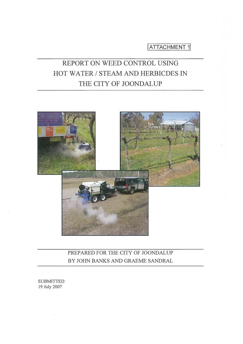
19.2 Cr. Griff Question on Notice - Would Council investigate the potential use of weed killing using steam?.............................................................................. 261
Representations by members of the public regarding closure of part of meeting
Adjournment Into Closed Session, exclusion of the media and public.............. 276
|
Council |
31 October 2018 |
Deputations (by prior arrangement)
31 October 2018
4.1 Request to address Council received prior to finalisation of the Agenda 9
|
Council 31 October 2018 |
Item 4.1 |
4.1. Request to address Council received prior to finalisation of the Agenda
Requests to Address Council regarding matters on the Agenda 31 October 2018
General Manager
Requests to address Council
The following requests to address Council regarding items to be included in the Agenda for the Council meeting 31 October, 2018 were received prior to publication of the Agenda.
· Mr Garrett Barry, Garret Barry Planning Services regarding Wolumla Planning Proposal
· Mr John Preston regarding Quaama Men's Shed Lot 10 Sec 10 DP 758860
Attachments
Nil
Council |
31 October 2018 |
9.1 Revised Companion Animals Control Areas Procedure.......................... 11
9.2 Report on public exhibition of Wolumla Deferred Matters Planning Proposal..................................................................................................... 78
|
Council 31 October 2018 |
Item 9.1 |
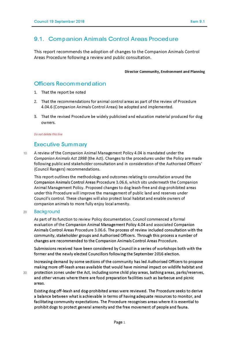
At the 19 September 2018 Ordinary Meeting of Council, a decision on the Companion Animal Control Areas Procedure was deferred pending an internal review of the Procedure to clarify Dog Prohibited Areas and to assess accessibility of Dog Off Leash Areas.
Director Community, Environment and Planning
Executive Summary
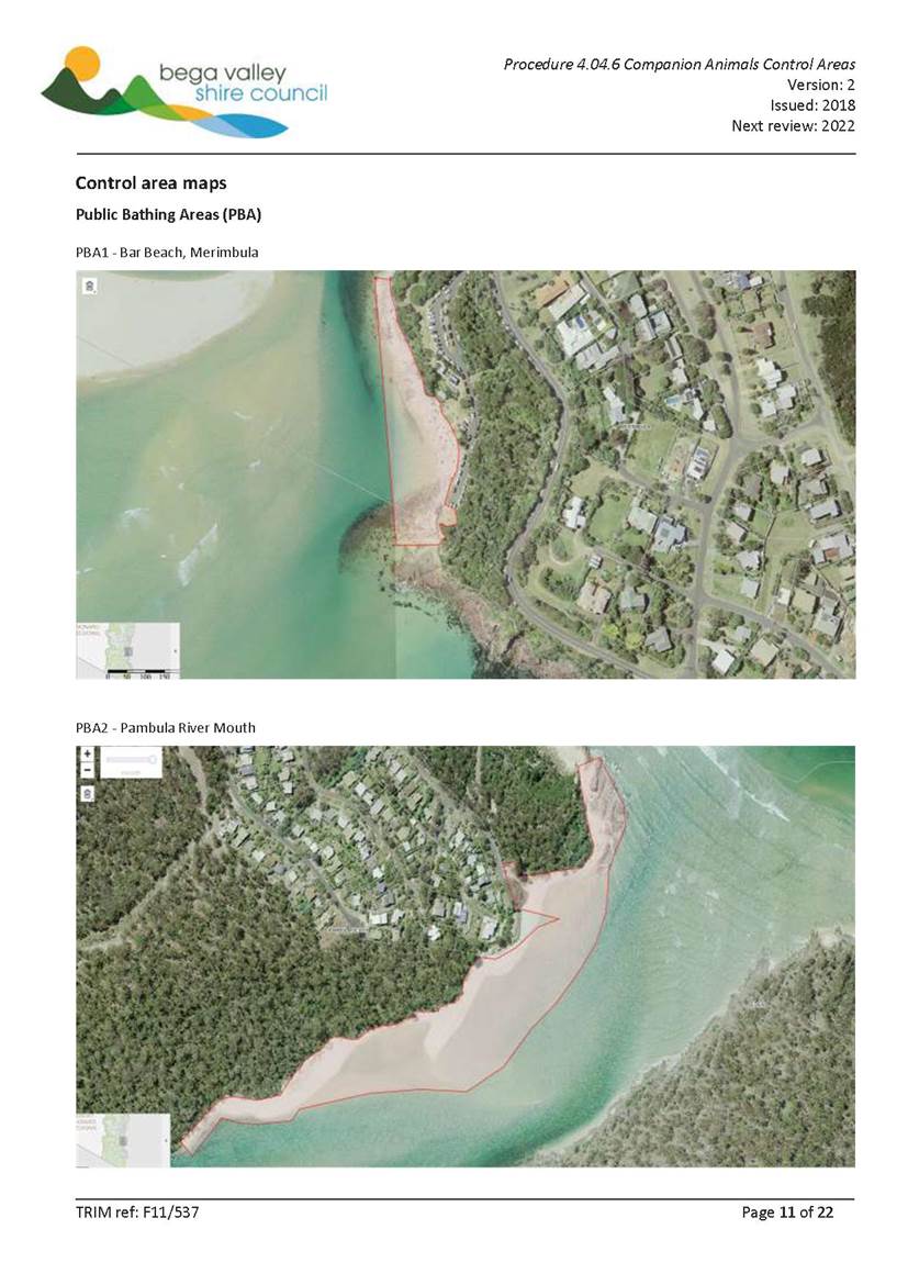
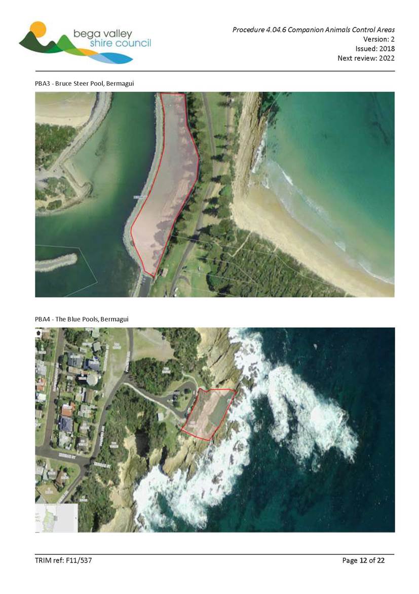
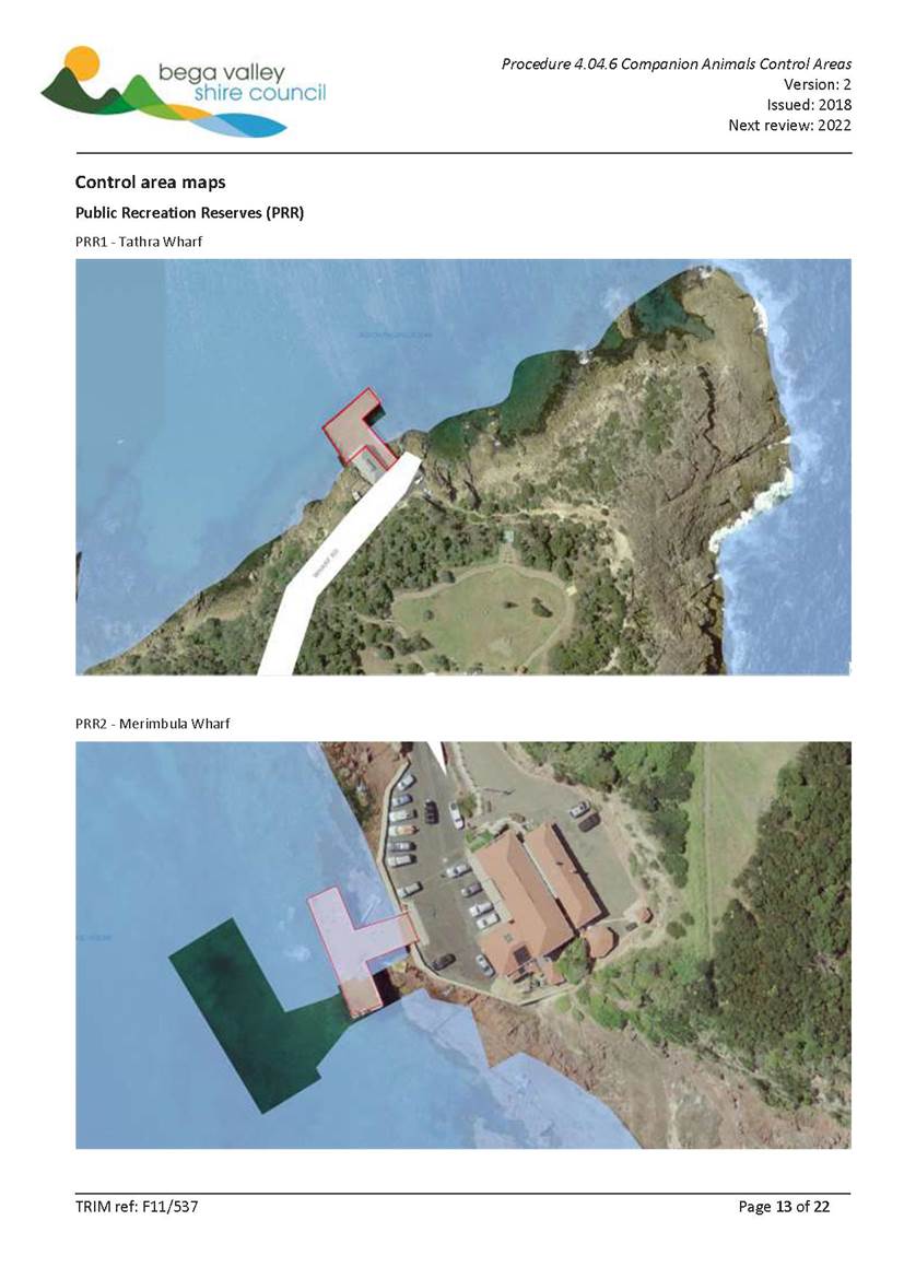
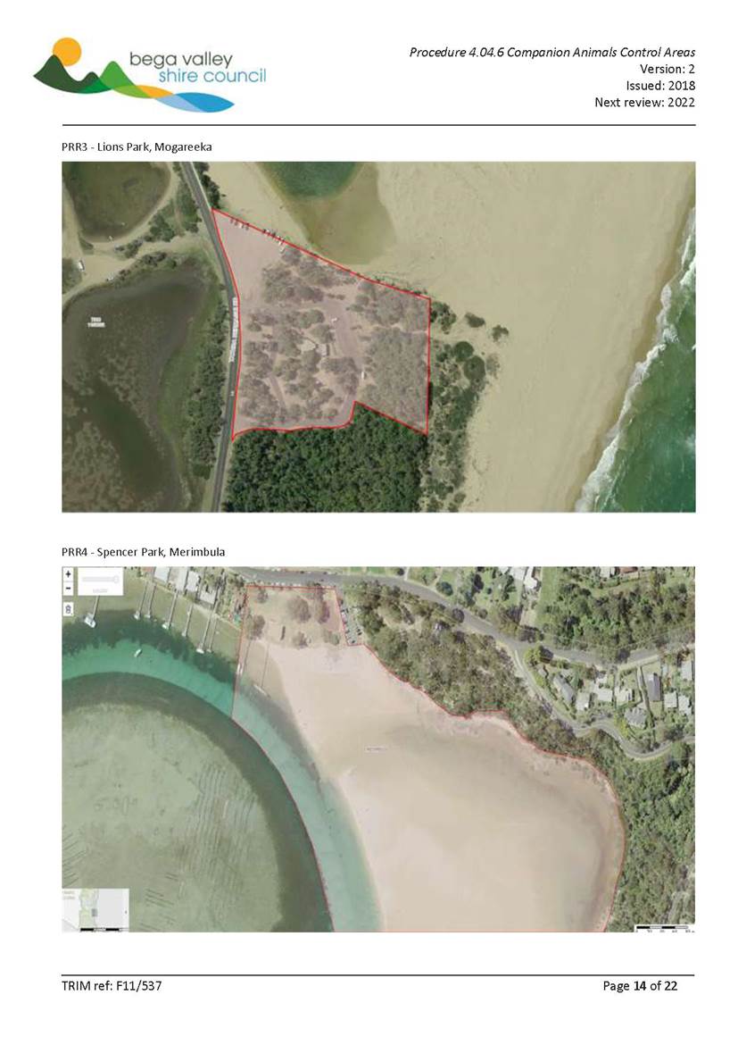
The revised Companion Animals Control Areas Procedure is presented for Council’s consideration, based on feedback and queries on the previous version presented on 19 September 2018. Officers have worked to simplify the Procedure and utilise maps to better explain to the public areas where dogs are prohibited, noting Council’s particular concerns around public bathing areas.
It is important to note the provisions in the Companion Animal Act 1998 (NSW) (the Act) apply unless Council puts in place dog prohibited areas as allowed under Section 14 of the Act.
In addition, Section 13 of the Act states: “Responsibilities while dog in public place: (1) A dog that is in a public place must be under the effective control of some competent person by means of an adequate chain, cord or leash that is attached to the dog and that is being held by (or secured to) the person.”. This means that in all public places, unless a dog is prohibited by the Act or a Council Order then a dog must be under effective control as described.
Background
Council at its Ordinary Meeting of 19 September 2018 unanimously resolved:
“1. That Council defer the matter for further revision of wording and that this review specifically deals with accessibility access to on and off leash areas with a report back to Council for subsequent release to the community for feedback.
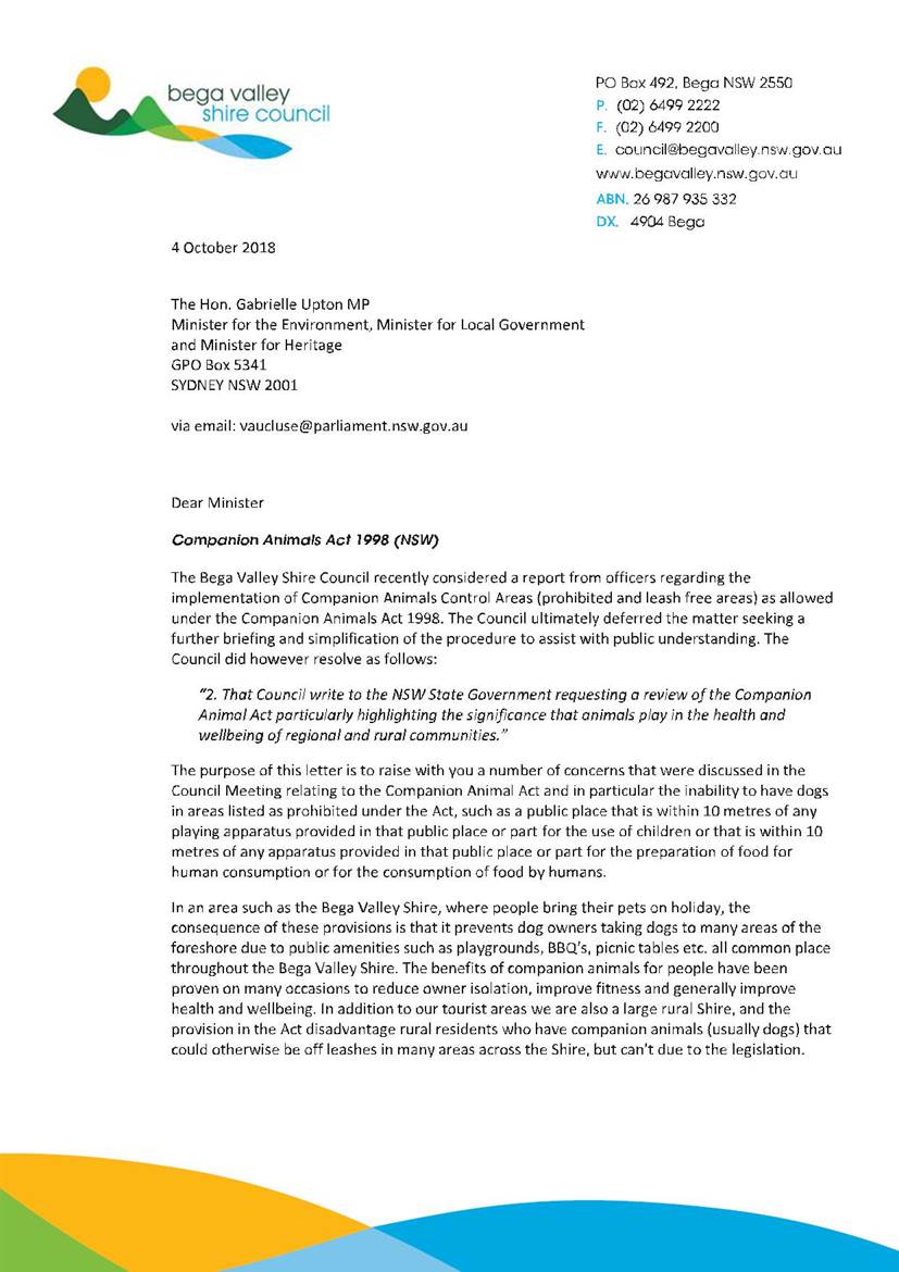
2. That Council write to the NSW State Government requesting a review of the Companion Animal Act particularly highlighting the significance that animals play in the health and wellbeing of regional and rural communities.”
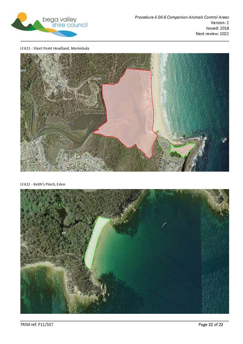
In relation to accessibility, as outlined above, a dog can be taken to any public area where dogs are not otherwise prohibited as long as they are under “…effective control…” as per Section 13 of the Act, thus people with limited mobility or a disability can take a dog to many areas of the Shire where hard surfaces allow for ease of access. (i.e. many footpaths and walking tracks such as Bermagui foreshore, Pambula to Merimbula path, Aslings beach path etc.). Short Point Headland is probably the most accessible off leash area given recent track works, however it may be possible with small modifications to improve accessibility of some areas or identify other areas that could provide accessible dog off leash areas. In addition, depending on the level of mobility, a number of the beaches listed as off leash areas also provide firm footing at low tides that allow for access. Each person’s circumstances will be different and they need to determine what best suits them, however Officers believe the current number and variety of off leash areas gives the community choice across the Shire.
The Mayor wrote to the Hon. Gabrielle Upton MP, Minister for Local Government on the 4 October 2018 as per Resolution 2, raising a number of concerns about the impact of the Act on resident’s ability to actively enjoy life with their dogs. At the time of publication of the Business Paper no response had been received.
Options
As outlined in the Legal/Policy section of this report, Council as the local authority has an opportunity to set dog prohibited areas as described under the Act, others are controlled by the legislation and not open to amendment. Officers have attempted to strike a balance through increasing dog off leash areas versus areas where dogs are prohibited. These are outlined in the Procedure.
Council can choose to accept the Officers’ recommendations or provide direction on how it wishes to proceed with companion animal control areas.
Community Engagement
Consultation undertaken
Consultation undertaken was outlined in the attached previous report of 19 September 2018.
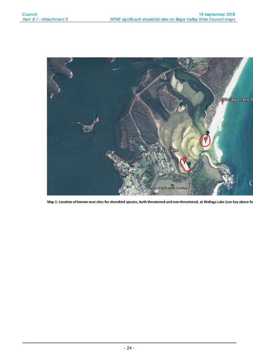
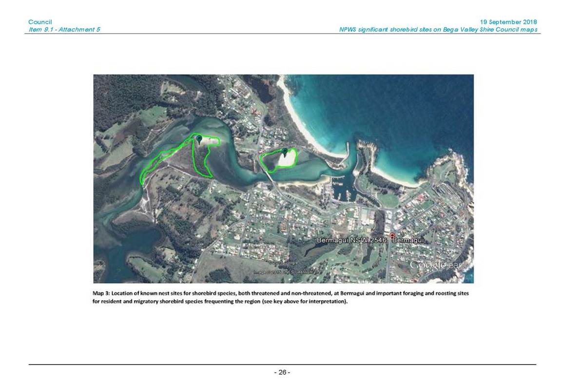
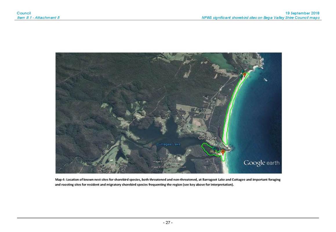
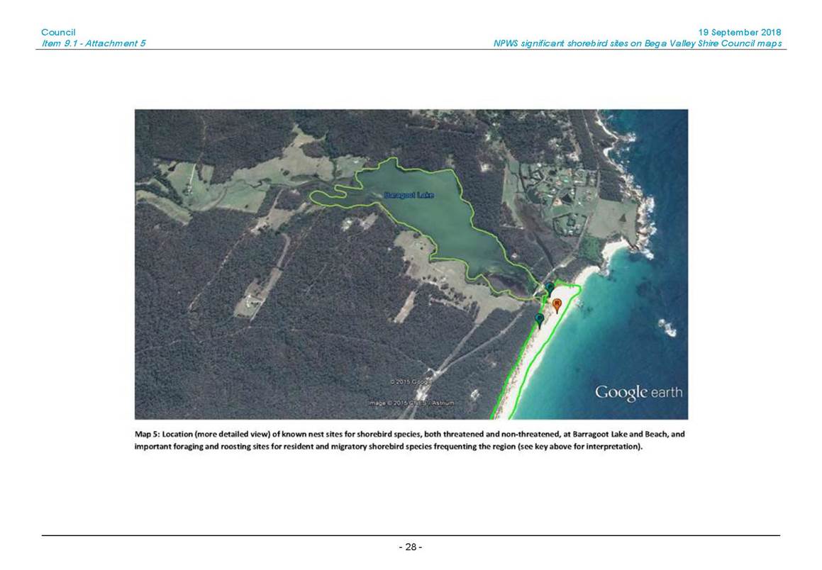
Although no formal request for submissions was sought, an email from Ms Joynes in regard to this matter and dogs on Barragoot Bay Beach was received and is attached for information.
Consultation Planned
Once adopted the new Procedure and the requirements of the Procedure will be widely publicised.
Council consideration of input
As outlined in the previous attached Council report.
Financial and resource considerations
The revised Procedure does not impact the financial requirements as outlined in the previous attached Council report.
Legal /Policy
Section 14 of the Companion Animal Act 1998 (NSW) states (highlighted areas to acknowledge those areas where it is up to the local authority (Council in this case) to determine if dogs are prohibited or not):
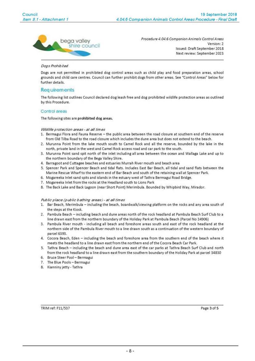
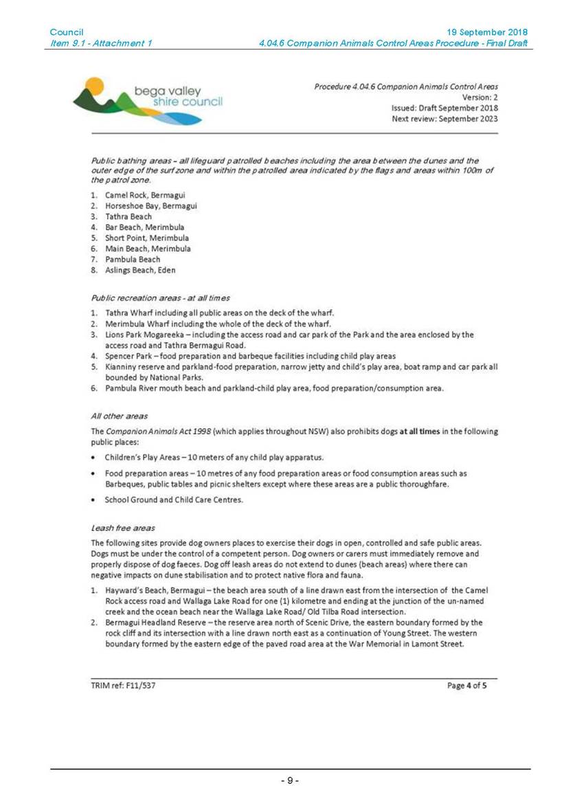
Section 14 of the Act states that dogs are prohibited in the following places (whether or not they are leashed or otherwise controlled):
(a) Children’s play areas (meaning any public place, or part of a public place, that is within 10 metres of any playing apparatus provided in that public place or part for the use of children).
b) Food preparation/consumption areas (meaning any public place, or part of a public place, that is within 10 metres of any apparatus provided in that public place or part for the preparation of food for human consumption or for the consumption of food by humans).
(c) Recreation areas where dogs are prohibited (meaning any public place, or part of a public place, provided or set apart by a local authority for public recreation or the playing of organised games and in which the local authority has ordered that dogs are prohibited and in which, or near the boundaries of which, there are conspicuously exhibited by the local authority at reasonable intervals notices to the effect that dogs are prohibited in or on that public place or part).
(d) Public bathing areas where dogs are prohibited (meaning any public place or any part of a public place that is used for or in conjunction with public bathing or public recreation (including a beach), in which the local authority has ordered that dogs are prohibited and in which, or near the boundaries of which, there are conspicuously exhibited by the local authority at reasonable intervals notices to the effect that dogs are prohibited in or on that public place).
(e) School grounds (meaning any property occupied or used for a purpose connected with the conduct of a government school or non-government school under the Education Act 1990. other than any property used for a residence or the curtilage of a residence).
(f) Child care centres (meaning any property occupied or used for a purpose connected with the conduct of a child care service as defined in the Children (Care and Protection) Act 1987, other than any property used for a residence or the curtilage of a residence).
(g) Shopping areas where dogs are prohibited (meaning a shopping arcade or shopping complex, including any part of it that is used by the public for parking or access to shops, in which or part of which the local authority has ordered that dogs are prohibited and in which, or near the boundaries of which, there are conspicuously exhibited by the local authority at reasonable intervals notices to the effect that dogs are prohibited there). This paragraph does not apply to any shop or part of a shop.
(h) Wildlife protection areas (meaning any public place or any part of a public place set apart by the local authority for the protection of wildlife and in which the local authority has ordered that dogs are prohibited for the purposes of the protection of wildlife and in which, or near the boundaries of which, there are conspicuously exhibited by the local authority at reasonable intervals notices to the effect that dogs are prohibited in or on that public place).
Impacts on Strategic/Operational/Asset Management Plan/Risk
Strategic Alignment
Revised 2017-2021 Delivery Program / 2018-2019 Operational Plan:
Outcome 4: Liveable Places. Goal 7: Our Shire continues to be a vibrant, enjoyable, safe and affordable place to Live.
Environmental / Sustainability
As outlined in the previous attached Council report.
Risk
As outlined in the previous attached Council report.
Social / Cultural
As outlined in the previous attached Council report.
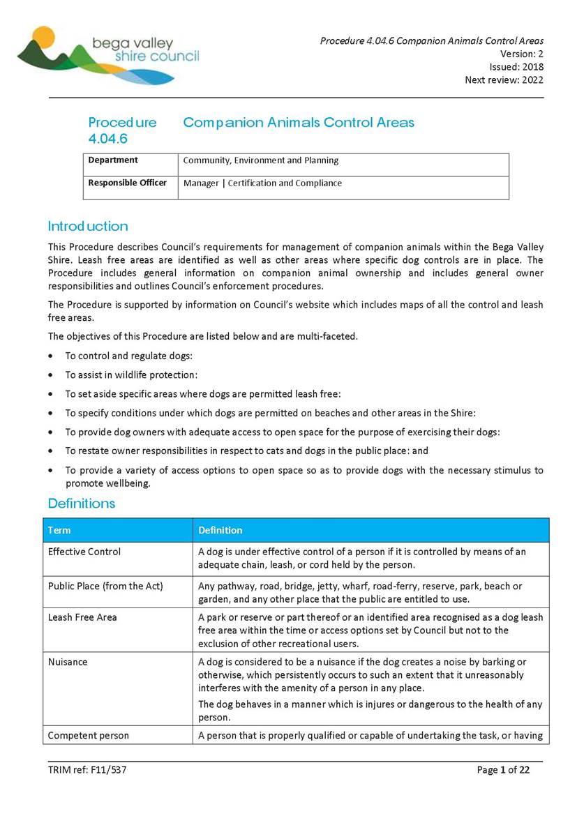
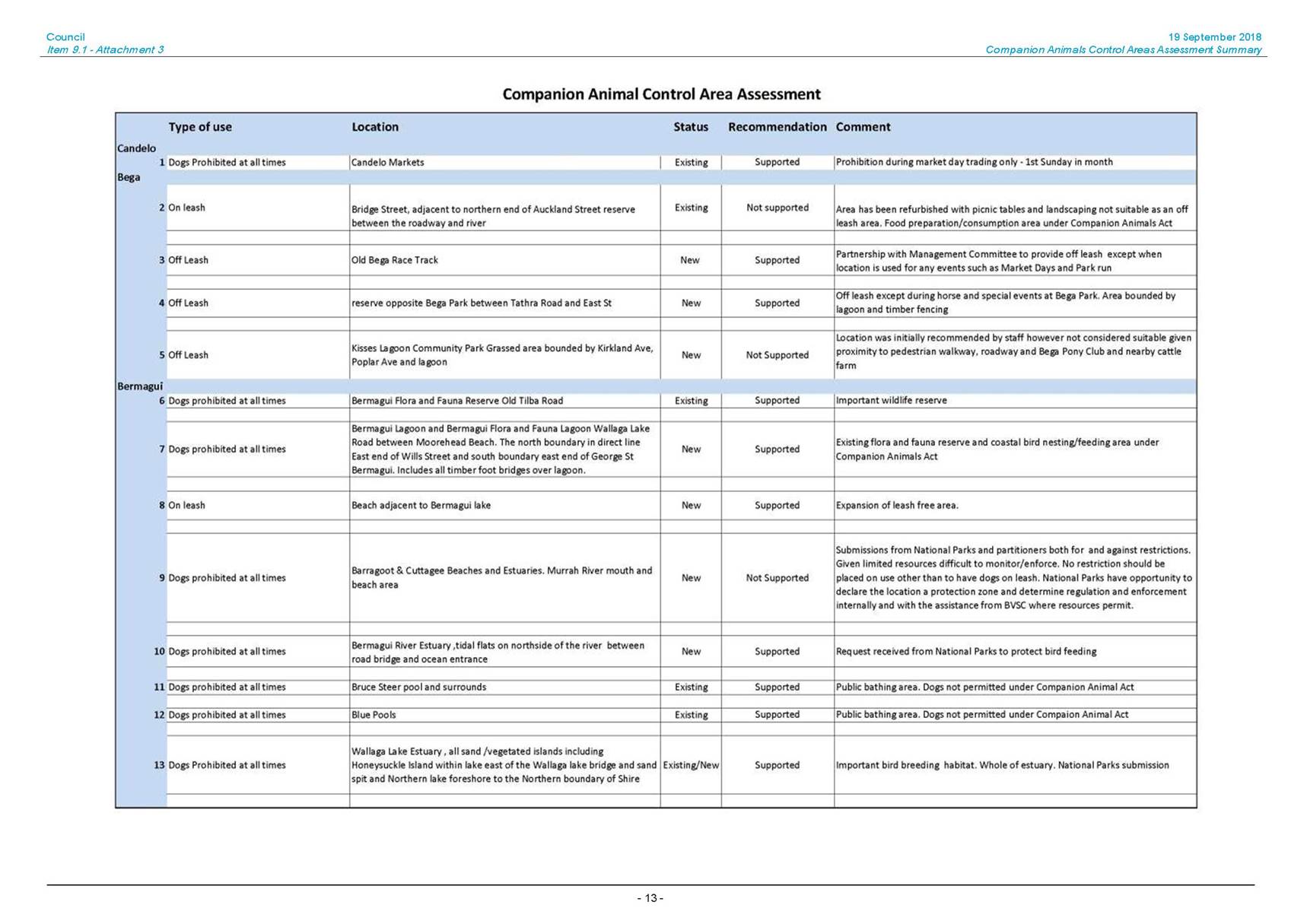
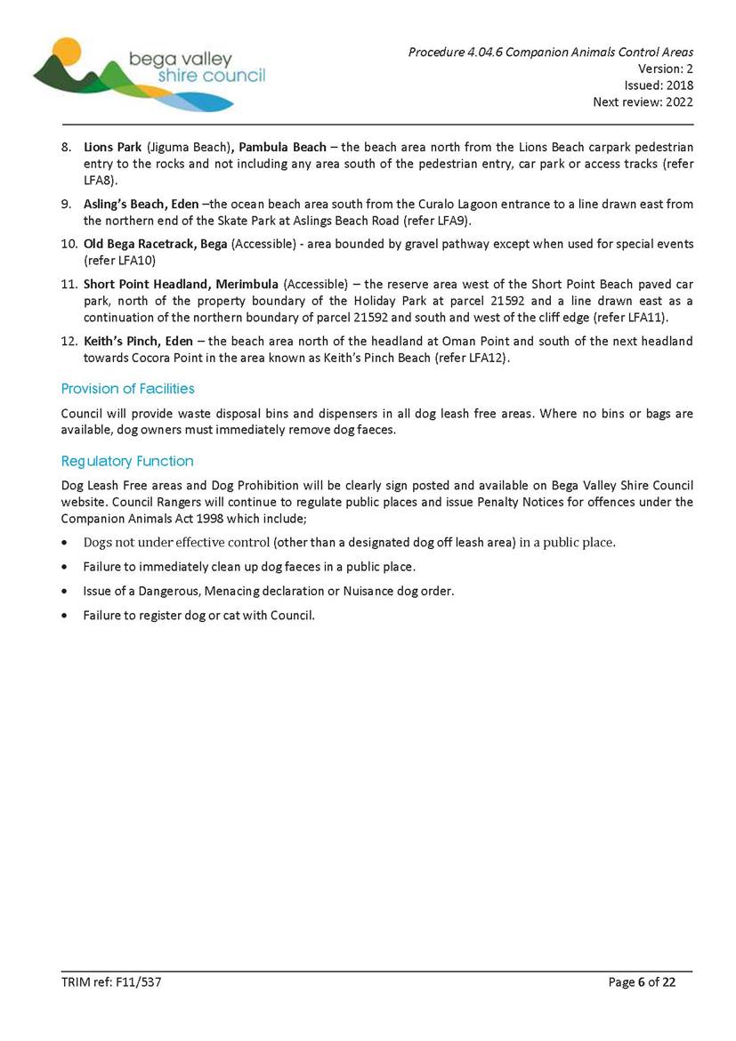
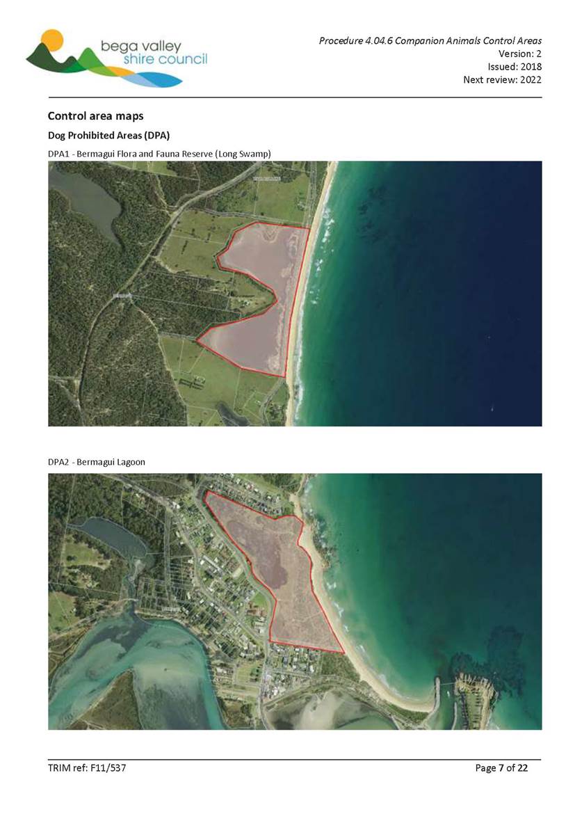
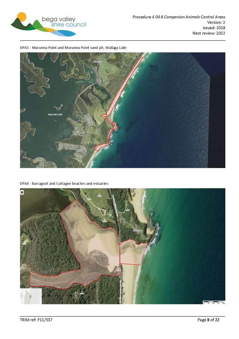
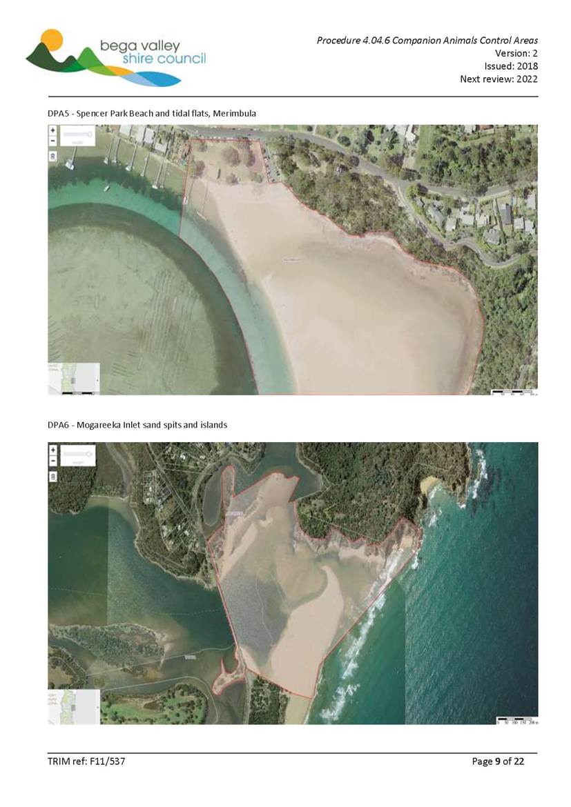
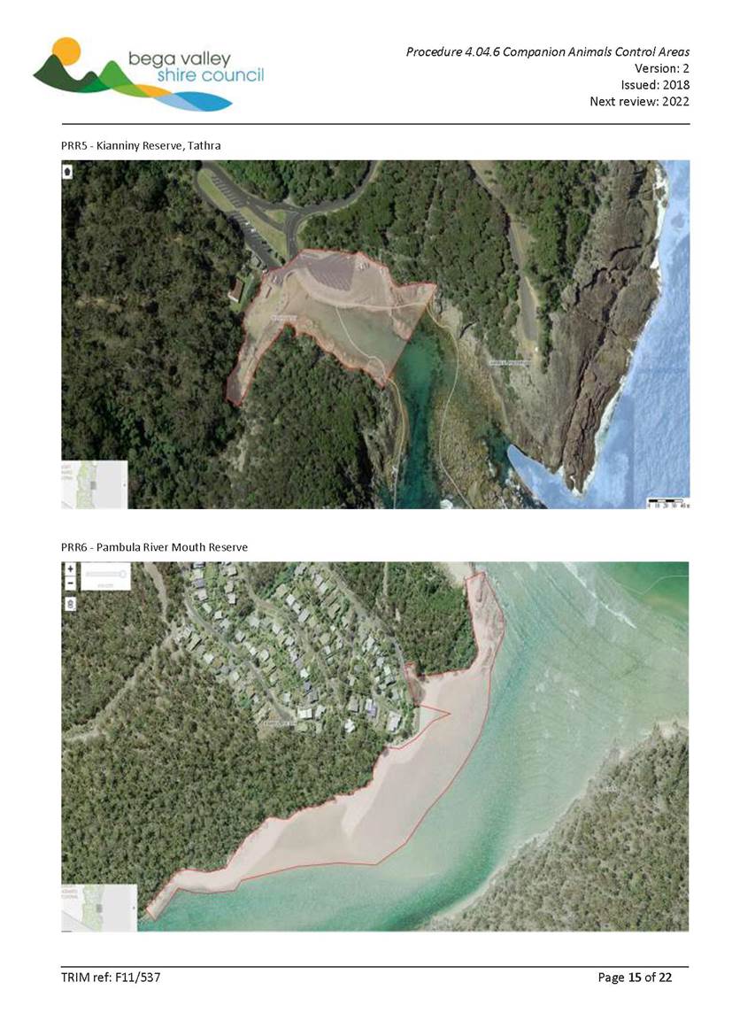
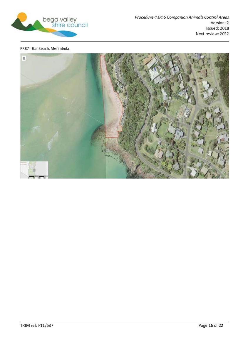
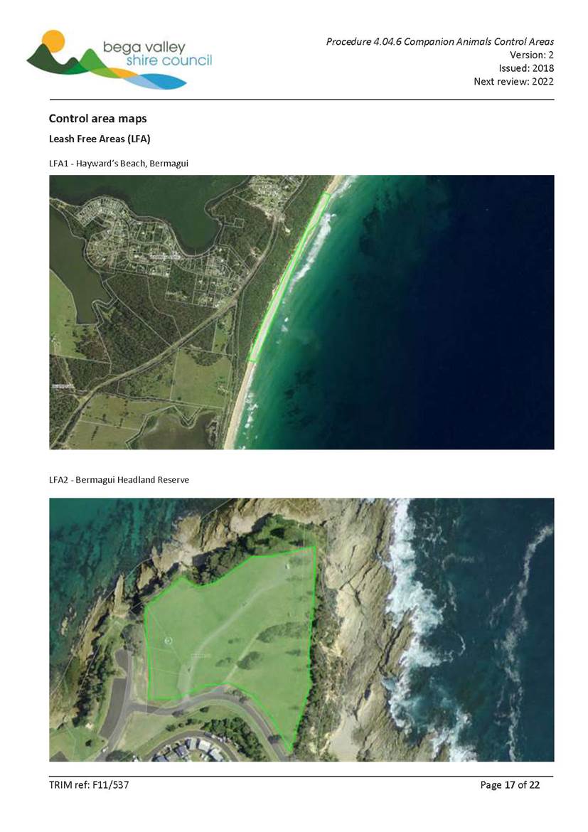
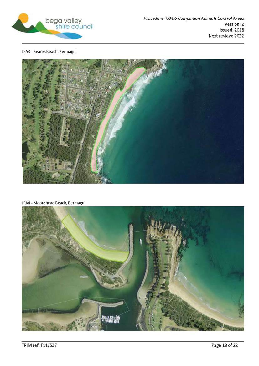
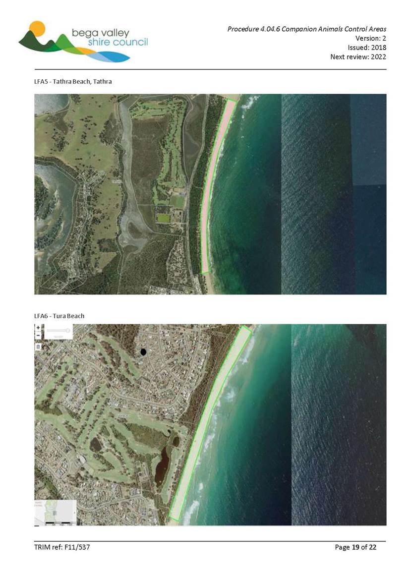
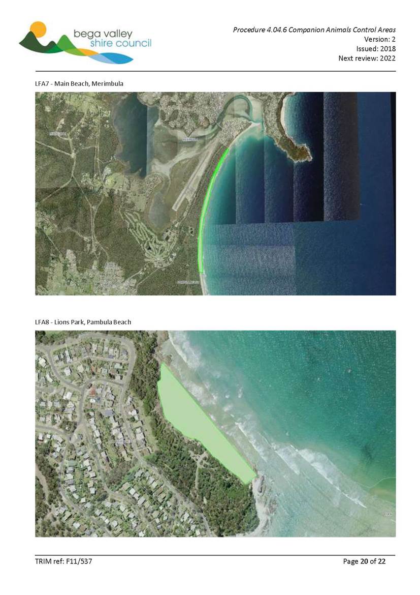
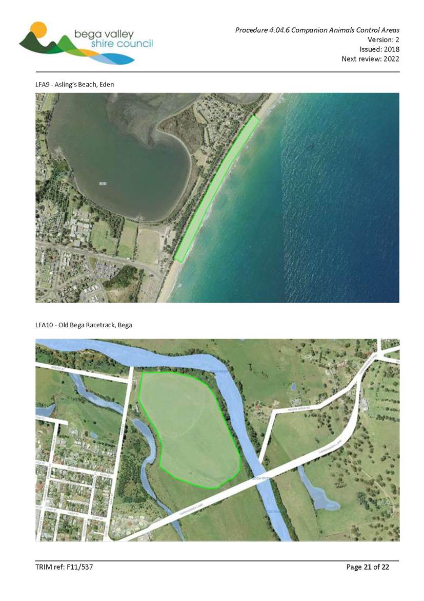
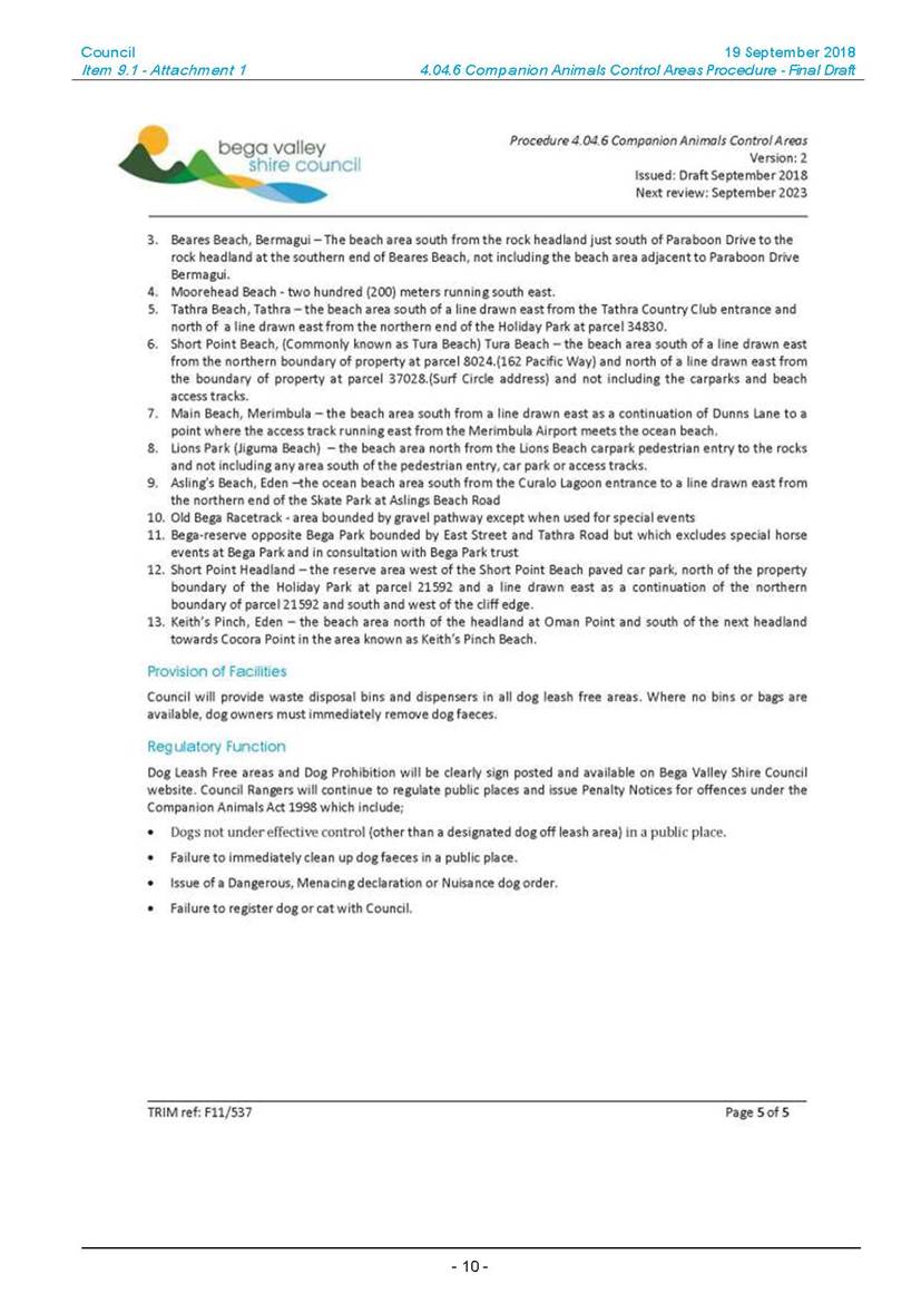
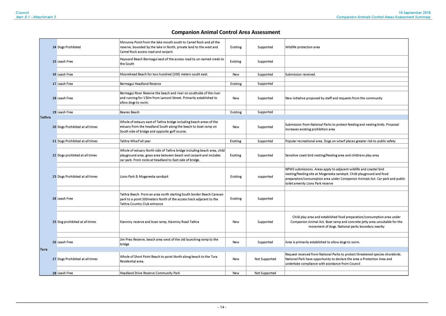
1⇩. Revised 4.04.6 Companion Animals Control Areas Procedure
2⇩. Mayoral Letter to the Hon Gabrielle Upton MP re Companion Animals Act 1998 (NSW)
3⇨. Email from Ms Joynes - Companion Animals Control Areas (Councillor Only)
4⇩. Companion Animals Control Areas Procedure Council Report - 3 October 2018
|
Council |
31 October 2018 |
|
Item 9.1 - Attachment 1 |
Revised 4.04.6 Companion Animals Control Areas Procedure |

|
31 October 2018 |
|
|
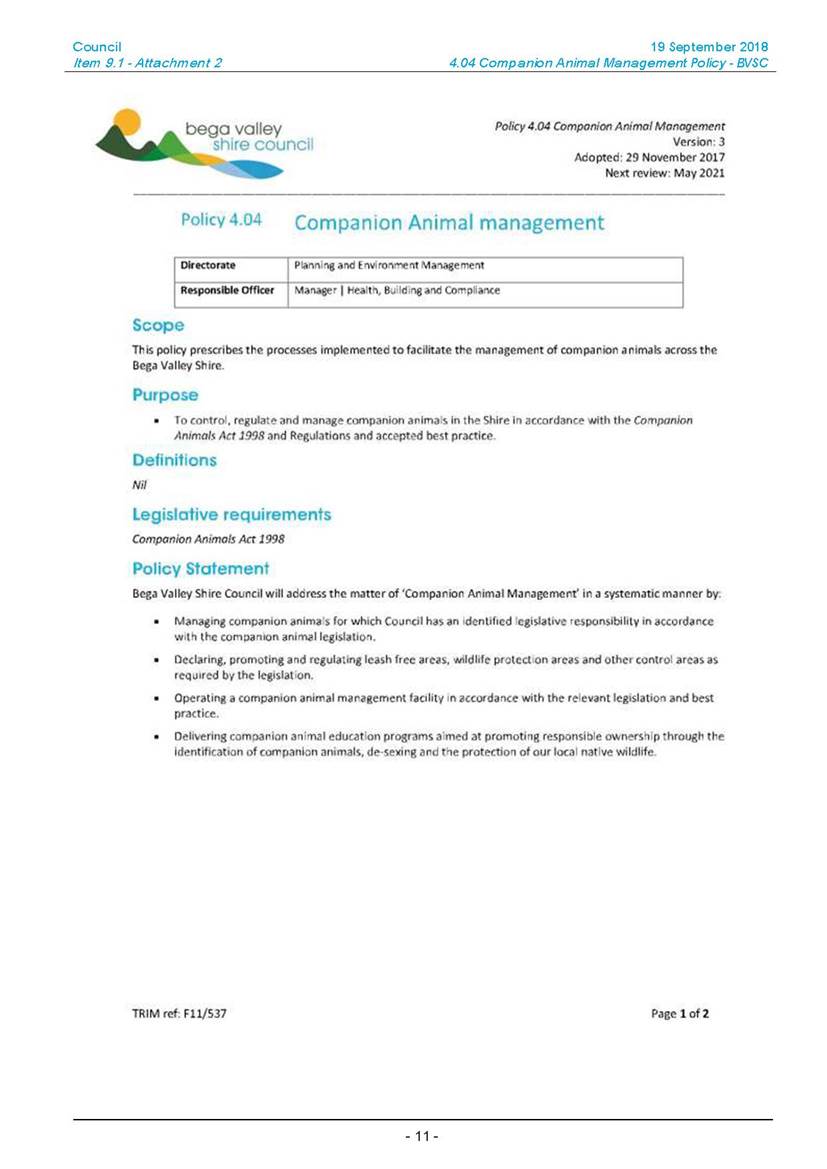
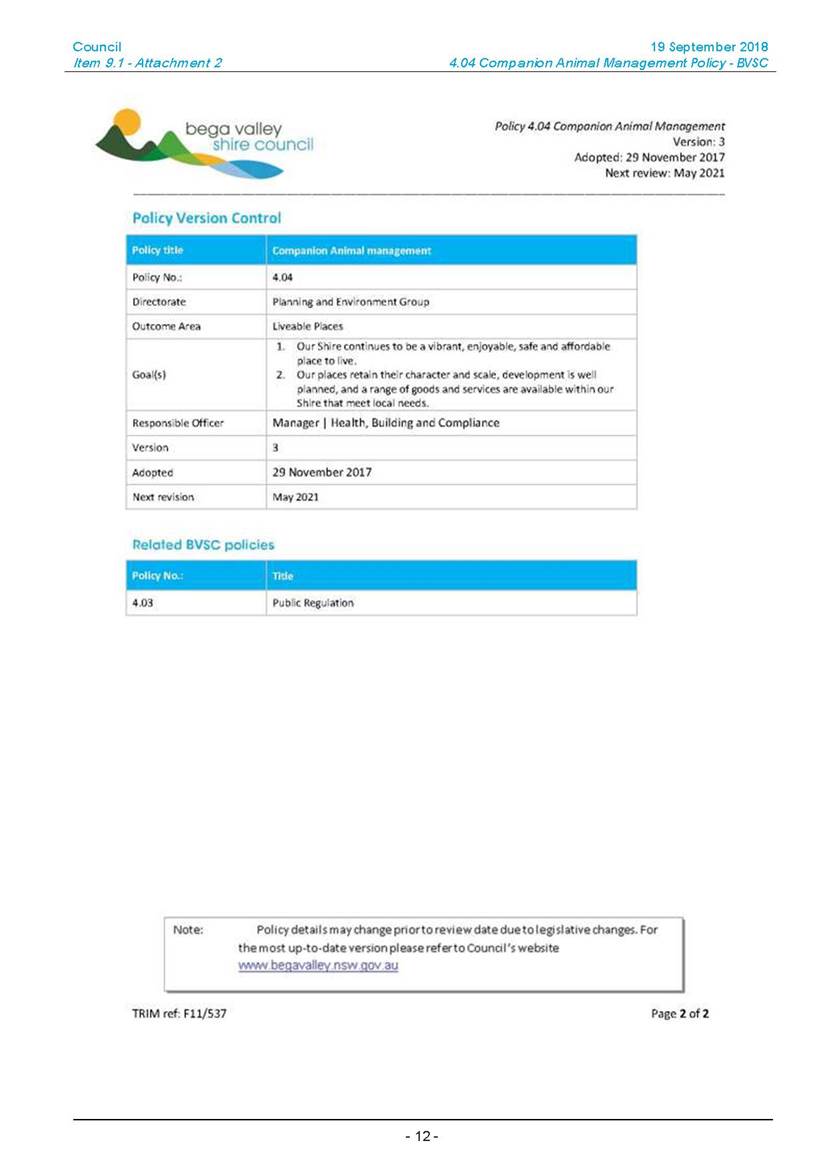
Item 9.1 - Attachment 2 |
Mayoral Letter to the Hon Gabrielle Upton MP re Companion Animals Act 1998 (NSW) |
|
31 October 2018 |
|
|
Item 9.1 - Attachment 4 |
Companion Animals Control Areas Procedure Council Report - 3 October 2018 |

|
Council |
31 October 2018 |
|
Item 9.1 - Attachment 4 |
Companion Animals Control Areas Procedure Council Report - 3 October 2018 |
|
Council |
31 October 2018 |
|
Item 9.1 - Attachment 4 |
Companion Animals Control Areas Procedure Council Report - 3 October 2018 |
|
Council |
31 October 2018 |
|
Item 9.1 - Attachment 4 |
Companion Animals Control Areas Procedure Council Report - 3 October 2018 |
|
Council 31 October 2018 |
Item 9.2 |
9.2. Report on public exhibition of Wolumla Deferred Matters Planning Proposal
This report seeks to finalise the draft Planning Proposal for Wolumla Deferred Matters.
Director Community, Environment and Planning
|
1. That Council finalise amendments to the Bega Valley Local Environmental Plan 2013 (Amendment No. 31) subject to the revisions detailed in this report and in accordance with the delegations issued by the Minister for Planning and Environment under Section 59 of the Environmental Planning and Assessment Act 1979. 2. That Council officers inform those who made a submission during the exhibition of the planning proposal. |
Executive Summary
Council at its meeting held on 13 December 2017 gave consideration to a report outlining the zoning and minimum lot sizes for 4 sites around Wolumla, that have remained deferred under Bega Valley Local Environmental Plan 2002.
The following recommendations were outlined in this report;
1. That Council resolve to adopt the zoning and lot sizing for Sites 1-4 as identified in Attachment 2 to this report.
2. That Council officers be authorised to forward this Planning Proposal for Wolumla Deferred Matters to the Department of Planning for Gateway Determination in accordance with the zonings and lot sizes recommended within this report.
3. That following Gateway Determination, the Planning Proposal is placed on public exhibition and following the exhibition period, a further report be submitted to Council for incorporation of these four sites within the Bega Valley Local Environmental Plan 2013.
4. That Council officers commence work on place based development plans for the villages that will link in with this Planning Proposal to provide a coordinated approach to the future development of Wolumla.
The planning proposal was sent to the Department of Planning on 3 January 2018 and a Gateway Determination was issued on 18 May 2018 subject to the Planning Proposal being publicly exhibited for a period of 28 days and consultation with Public Authorities.
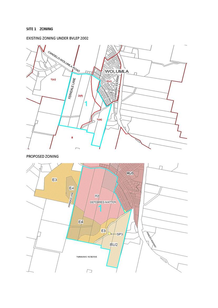
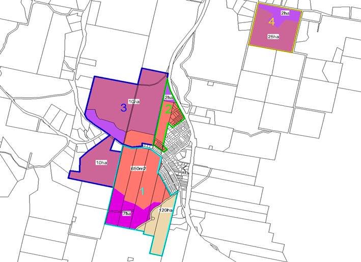
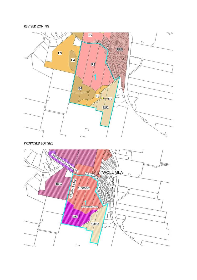
PROPOSED ZONING
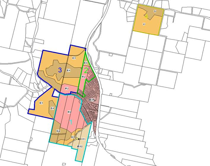
PROPOSED MINIMUM LOT SIZES
This report summarises the submissions received during the exhibition period and referral responses and recommends Council proceed to finalise the planning proposal.
Background
These four sites are deferred matters under Bega Valley Local Environmental Plan 2002 (BVLEP 2002) as the owners lodged submissions during the exhibition process for Bega Valley Local Environmental Plan 2013 (BVLEP 2013).
A report was presented to Council on 20 July 2016 and discussed at a Councillor workshop outlining the actions and investigations to be undertaken and a further report was presented to Council on 13 December 2017 recommending zoning and minimum lot sizes for all four sites. This report summarises the submissions and includes Council officers’ recommendations.
Community Engagement
Consultation undertaken
The planning proposal was exhibited for a period of 42 days, from 23 July 2018 until 7 September 2018 with two ‘drop in sessions’ arranged at the Wolumla Town Hall on the 1 August 2018 and 15 August 2018. The timeframe for consultation was also extended by 14 days to ensure there was sufficient time to review the proposed zoning and minimum lot sizes.
Notices were placed in the local newspapers and a copy displayed at the Bega Office and libraries in Bermagui, Tura Beach and Eden. The Gateway Determination required consultation with the Department of Primary Industries, NSW Office of Environment and Heritage, Roads and Maritime Services and the NSW Rural Fire Service.
A total of (9) submissions were received, (5) from Government Agencies and (4) public submissions.
Agency Submissions
Department of Primary Industries (DPI) – Fisheries
· Site 3 - Contains remnant vegetation bordering ephemeral streams. Degradation is a key threatening process under the Act and the DPI recommends rezoning the vegetated riparian corridors within site 3 as E2 in preference to E3.
Response: The E2 Environmental Conservation Zone does not permit residential development or the creation of a minimum lot size. This would compromise the future subdivision of this land as the riparian corridors meander through most of site 3.
The riparian corridor and vegetation buffer would be assessed as part of any future subdivision and the most practical approach would involve a restriction being placed on the title of the land and 88B Instrument as a Condition of Consent to prevent future clearing.
Department of Industry – Crown Lands
Recommend that the tenure of roads be addressed as part of any future development of the sites and future subdivisions are of sufficient size to contain any future Asset Protection Zones (APZs) on private land. Road closing timeframes can be lengthy.
· Site 1 – The Bega Valley Shire Council should seek to have this road transferred to their management to support the current use and future development. It is recommended that Lot 1 DP 947772 and Lot 65 DP 664914 be closed and purchased as part of any future subdivision.
· Site 3 – Consideration should be given to closing and purchasing the road contained within this property.
· Site 4 – Current and future land use should be considered within Lot 130 DP 1017007, Lot 1553 DP 831115 and Lot 173 DP 750238.
Response: The provision of APZs and the road tenure issues will be considered as part of any future Development Application for sites 1-4.
Office of Environment and Heritage
Do not object to the planning proposal. Advice has been provided about biodiversity, Aboriginal cultural assessment and flooding.
Sites 2 and 3 are the most constrained in terms of biodiversity and the cost of future clearing could make future development uneconomical. Any future development on the subject sites would require an Aboriginal cultural heritage assessment and the planning proposal would benefit from a floodplain risk assessment.
· Site 1 – Future development will require flooding and cultural heritage assessments. There is an Archaeological Heritage Impact Permit (AHIP) issued for the approved subdivision for a period of 10 years.
· Site 2 – A future subdivision will trigger the Biodiversity Offset Scheme (BOS). Certification is recommended prior to rezoning the land. Any future development will require an Aboriginal cultural heritage assessment.
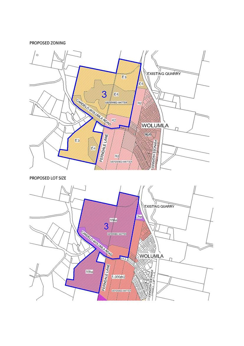
· Site 3 – It is unclear how the E3 Zone will protect biodiversity values and it is recommended that a 120ha minimum lot size be applied over the E3 Zone. Certification is recommended prior to rezoning the land. Any future development will require an Aboriginal cultural heritage assessment.
· Site 4 – Agree with recommendations. Any future development will require a cultural heritage assessment as three archaeological sites have been recorded.
Response: The majority of the subject land is identified as future urban under BVLEP 2002. A more detailed assessment in terms of biodiversity, Aboriginal cultural assessment and flooding would be undertaken as part of any future development. This planning proposal consists of larger greenfield sites where the inherent constraints can be considered as part of any future subdivision or development of the land. Officers are recommending a masterplan be prepared for sites 1-3 prior to any future subdivision being approved.
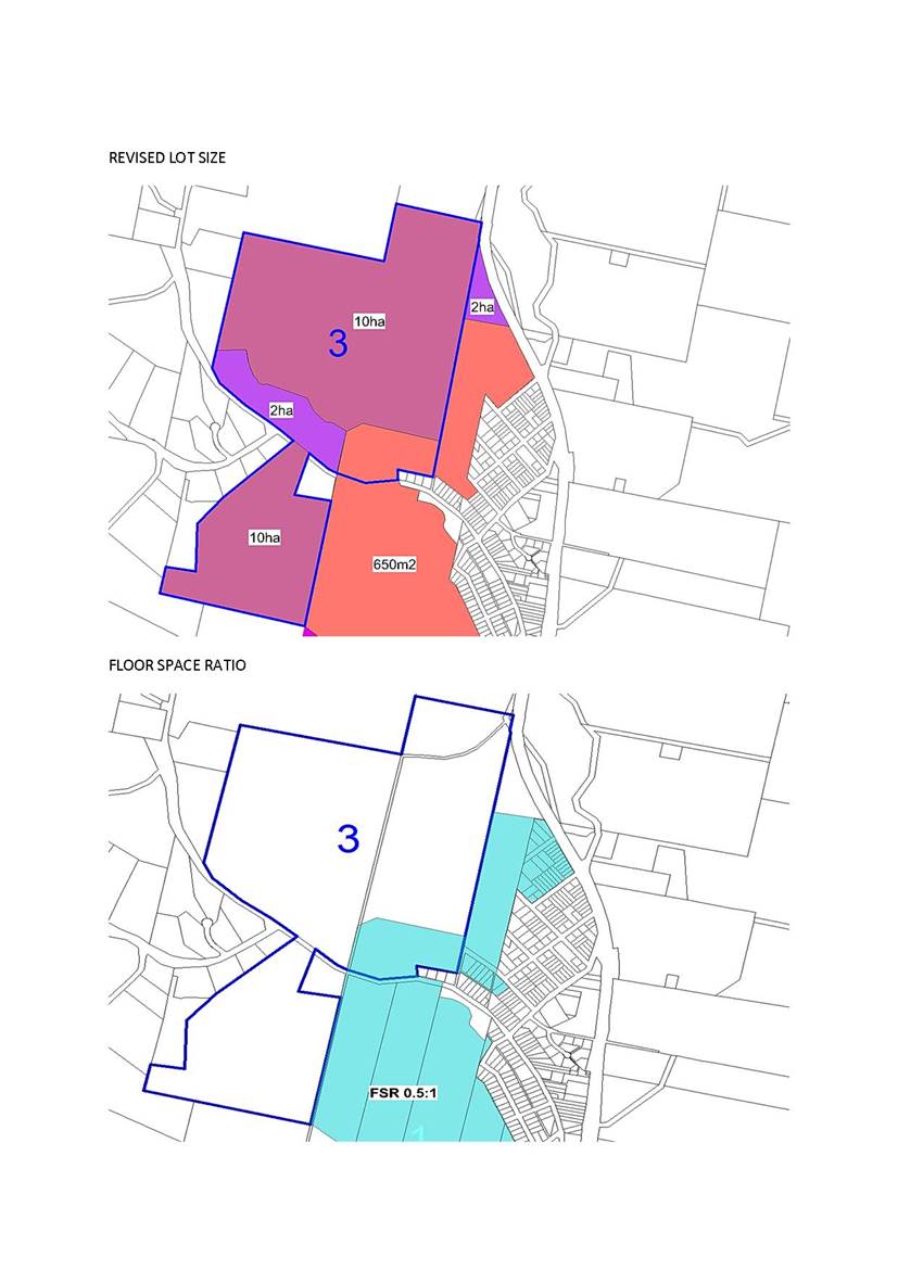
The 10ha minimum lot size has been recommended to facilitate lot averaging with larger lots over the more constrained land. The E3 land follows riparian corridors that flow through Site 3 in particular. The application of a 120ha minimum lot size would prevent any future subdivision of this land contrary to the objectives of this planning proposal and is a lot size associated with large broad scale rural zonings such as RU1 and RU2 zones.
NSW Rural Fire Service
Consultation has been undertaken with the NSW Rural Fire Service who will provide more detailed advice and assessment as part of any future subdivision of the land.
Roads and Maritime Services (RMS)
Object to the planning proposal in its current format.
The potential to facilitate 697 new lots with no assessment on the intersections with the Princes Highway, Candelo-Wolumla Road, Bega Street and Old Mill Road. Recommends planning mechanisms to obtain contributions and deliver upgrades to infrastructure at rezoning stage.
A traffic impact study has been requested that considers the suitability of intersection treatments and identify any upgrades. Strategic designs and costings should be developed with contributions identified to fund and deliver the required road network. Improvements to road infrastructure will need to clarify the scope of works and demonstrate construction within the road reserve.
Sites 2 and 3 – The RMS prefer to deny access to classified roads where alternative local road access is available. Direct access to the Princes Highway is not permitted. Council needs to identify the opportunities to reduce or remove access points to the Princes Highway.
Response: The majority of this land has been zoned residential since 1987 and is currently zoned 2(f) Future Urban with a minimum lot size of 550m2 under BVLEP 2002. Council outlined zonings and minimum lot sizes as part of the standard instrument process similar to those outlined in this planning proposal.
This planning proposal involves the rationalisation of existing residential land and minimum lot sizes that better reflect the natural constraints of the land rather than up zoning or any significant increase in the development potential of the land. The calculations within the planning proposal are a maximum yield but the reality is that any future subdivision is likely to be smaller with a mixture of lot sizes, including larger lots over the more constrained land. When the road network, infrastructure requirements, riparian corridors and steep land are taken into account, the overall lot yield is likely to be much less than the 697 lots which is a mathematical calculation based on the size of the land and lot size only.
It is considered it would be more appropriate to require a traffic study at the masterplan stage where it would directly relate to lot yield, subdivision layout, road design and intersection locations.
The existing speed environment along the Candelo-Wolumla Road has been discussed, particularly the possibility of extending the existing 50km zone further to the west to align with the existing 2(f) zone and proposed zonings that form part of this planning proposal.
This planning proposal does not involve the creation of new residential land but recommends zonings and lot sizes over existing residential land as part of the standard instrument process and multiple land owners with different objectives, timeframes and budgets.
Advice was sought from the Department of Planning who confirmed that Council would lose their delegations if a referral agency objects to the planning proposal as detailed in the Gateway Determination. It is therefore recommended the preparation of a masterplan including a detailed traffic study and servicing plan be required prior to any future development application for sites 1-3.
This is required in order to address the advice of the RMS and ensure any future infrastructure costs are costed and properly outlined by the developers of each site.
Summary of Public Submissions
A total of (4) submissions were received, (3) submissions were received from the owners of property subject of this planning proposal and another was received from an owner outside of the planning proposal wishing to have their property rezoned.
(A copy of all submissions will be tabled at the Council Meeting).
Site 1
The following recommendations were made at the Council Meeting on 13 December 2017;
· R2 zoning with a 1,000m2 minimum lot size
· E3 and E4 zoning with a 7ha minimum lot size
· SP3 and RU2 zoning with a 120ha minimum lot size
The following is a summary of the requested changes;
· Lot size for the R2 zoned section reduced from 1,000m2 to 650m2 and proposed E4 zone reduced to 1ha.
· Reduction in the size of the RU5 Village Zone.
· A lot size of 15ha is applied to the residue of Lot D under DA2004.1006.
Response: These proposed changes have been reviewed within the context of the site and justification provided with the submission.
· Reduction in the minimum lot size for the R2 zone from 1,000m2 to 650m2
The client has engaged a consultant who is currently preparing a masterplan for Site 1 with a detailed subdivision layout. This concept is nearing completion and includes a mixture of lot sizes with 110 smaller lots being less than 900m2, 50 lots between 1200m2 and 2000m2 and 12 lots above 2000m2.
The overall lot yield, with the inclusion of road infrastructure and riparian corridors is similar to that estimated within the planning proposal and supported for the proposed R2 portion. The reduced minimum lot sizes would ensure that valuable R2 zoned land would not be sterilised and also provide a variety of lot sizing.
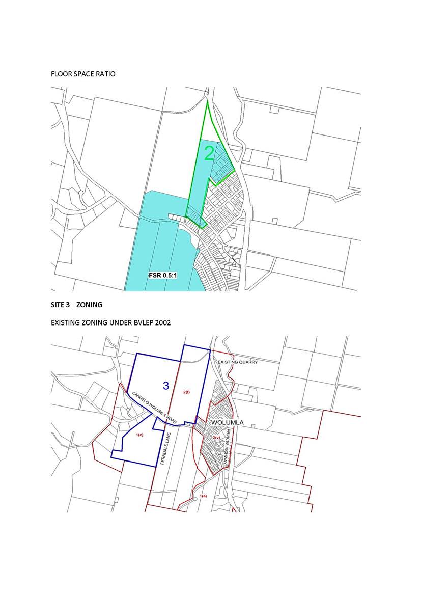
A Floor Space Ratio of 0.5:1 would also be applied over the R2 zone which is consistent with Council’s approach to the use of the R2 zone.
· Reduction in the size of the RU5 Village Zone
A request has been received to reduce the size of the RU5 Village Zone to align with the existing subdivision approved subdivision layout DA2007.749.
· A lot size of 15ha is applied to the residue of Lot D under DA2004.1006
The residue of this subdivision approval currently extends from the eastern side of Mine Lane over the remainder of Site 1. Lot D was originally created as a residue and retains this building entitlement under Clause 4.2A of BVLEP 2013. Disposing of land to the west would not alter the residue status of this block. This block retains a building entitlement and an amendment to the minimum lot size is therefore not required.
· Reduction in the minimum lot size for the E4 zone from 7ha to 1ha
The application of a 1ha minimum lot size is not supported as the majority of this land is swampy, low-lying land set against a steep ridgeline as identified in the Bega and District Strategic Directions Report (adopted by Council – January 2006). These inherent constraints limit any future development. It is therefore recommended that the 7ha minimum lot size be retained.
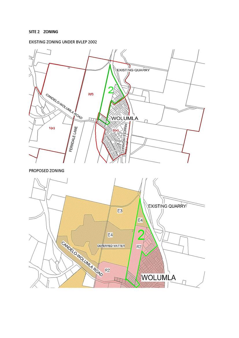
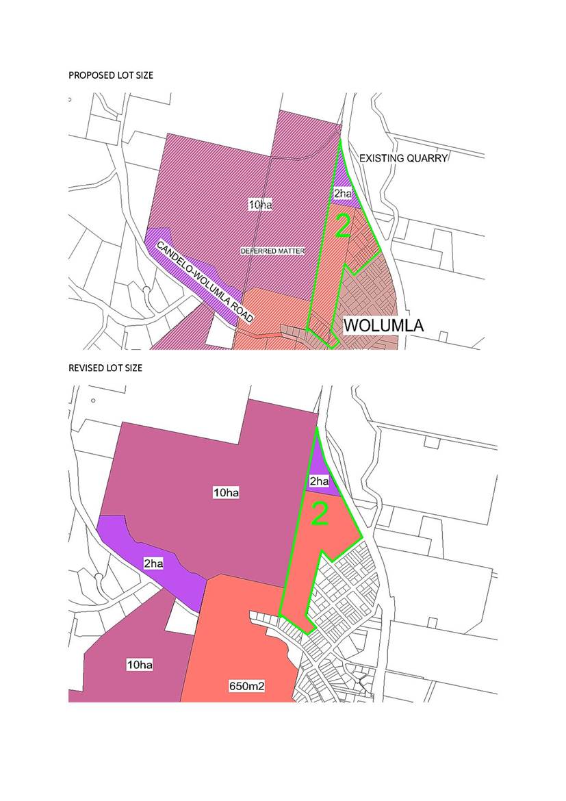
Site 2
The following recommendations were made at the Council Meeting on 13 December 2017;
· R2 zoning with a 1,000m2 minimum lot size
· E4 zoning with a 2ha minimum lot size
The following is a summary of the requested changes;
Minimum lot size for Lots 2, 8-13 DP 3833 and Lots 16-17 DP 997 is reduced to 550m2 with an FSR of 0.5:1. Lot sizing for the remaining R2 land be variable from 550m2 to 1,000m2.
· E4 land is rezoned to R2 with a flora and fauna assessment provided.
Response: These proposed changes have been reviewed and a reduction to the minimum lot size to 550m2 and rezoning of the E4 portion to R2 is not supported.
A reduction to a minimum lot size of 650m2 is supported for the R2 zone which is consistent with site 1.
The rezoning of the E4 portion to R2 is not supported. This land has inherent biodiversity values as detailed in the planning proposal and the advice from OEH. The E4 zoning is consistent with these attributes and rezoning to R2 is not recommended. A detailed flora and fauna report has not been provided.
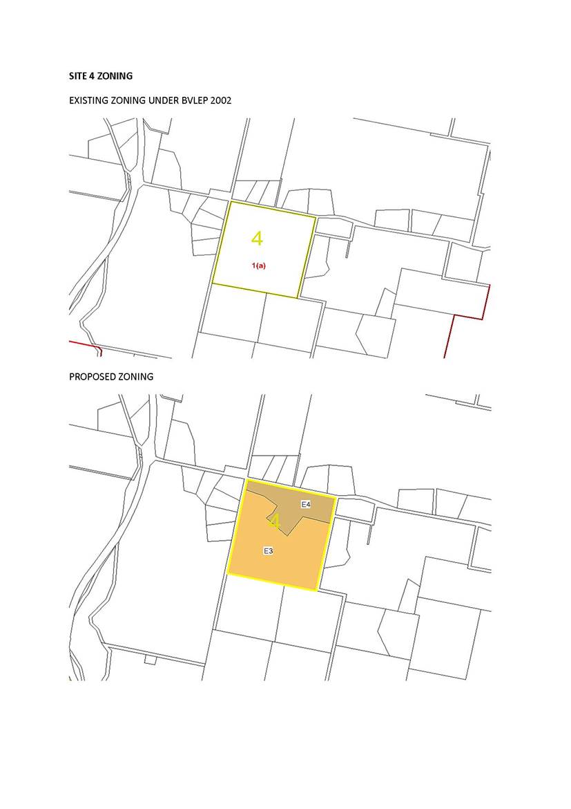
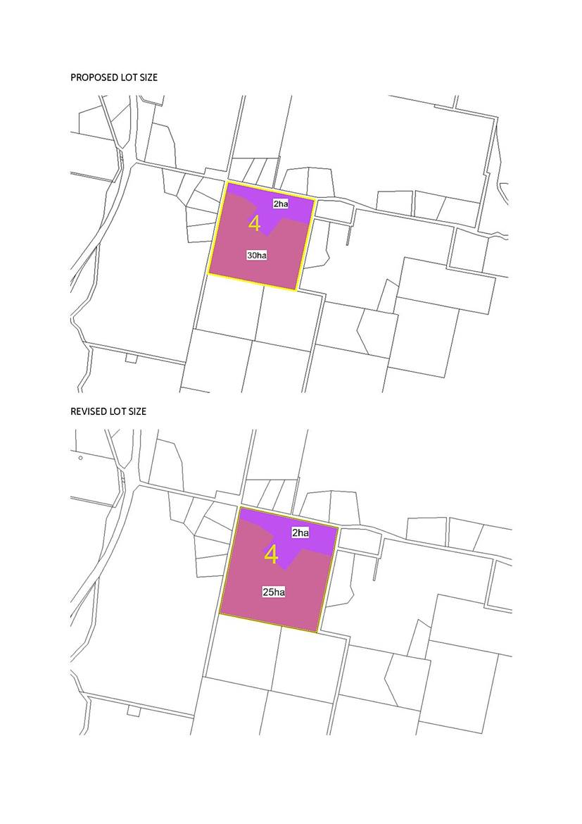
Site 4
The following recommendations were made at the Council Meeting on 13 December 2017;
· R3 zoning with a 2ha minimum lot size
· E4 zoning with a 25ha minimum lot size
The following is a summary of the requested changes;
The minimum lot size of the E3 zone be reduced to 20ha or 25ha so there is no issue with the dwelling entitlement for the residue block as the block would be below 30ha.
Response:
This request has been researched and is supported. The minimum lot size can be reduced to 25ha without changing the entitlement provided by the planning proposal. It was always intended that the residue allotment would have an entitlement and a reduction from the 25ha minimum lot size would not provide any additional dwelling opportunities.
Lot 2 DP 964548
The owners have requested a rezoning to permit the subdivision of an additional allotment. Their property is currently zoned RU1 Primary Production with a minimum lot size of 120ha.
Response:
This request does not form part of this planning proposal or any ongoing review. The owners would need to submit a separate planning proposal with justification to amend the minimum lot size for their property.
Conclusion
That Council finalise amendments to the Bega Valley Local Environmental Plan 2013 (Amendment No. 31) subject to the following revisions;
· The Minimum Lot Size for the proposed R2 Zone is reduced from 1,000m2 to 650m2 with a Floor Space Ratio (FSR) of 0.5:1 for Sites 1-3.
· A Minimum Lot Size of 25ha is applied to the proposed E3 Zone within Site 4.
· A reduction in the extent of the proposed RU5 Village Zone to align with the approved subdivision boundary.
· That a masterplan including a detailed traffic study and servicing plan be provided prior to any future development application for sites 1-3. Attachments
1⇩. Attachment 1 - Proposed Zonings and Minimum Lot Sizes for Sites 1-4
|
Council |
31 October 2018 |
|
Item 9.2 - Attachment 1 |
Attachment 1 - Proposed Zonings and Minimum Lot Sizes for Sites 1-4 |
10.1 Proposed divestment of land to Quaama Men's Shed Incorporated..... 98
10.2 Disposal of Easement - Merimbola Street, Pambula............................. 106
10.3 Tura Marrang Library and Community Centre - Lower level redevelopment and former Managers Residence................................. 112
|
Council 31 October 2018 |
Item 10.1 |
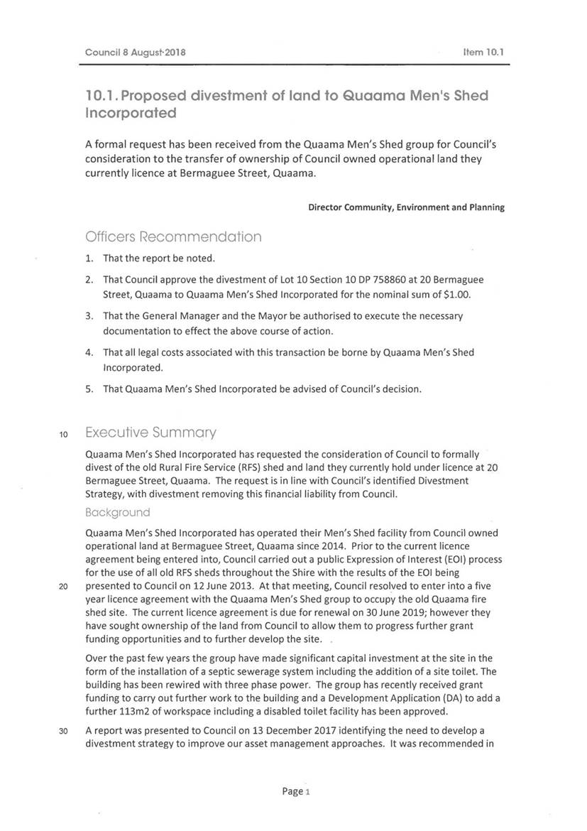
10.1. Proposed divestment of land to Quaama Men's Shed Incorporated
Formal advice has been received from Quaama Men’s Shed Incorporated, declining Council’s offer to transfer ownership of Lot 10 Section 10 DP 758860 at 20 Bermaguee Street, Quaama.
Director Community, Environment and Planning
|
1. That Council receive and note the report. 2. That Council continue with the current Licence Arrangement which does not expire until 30 June 2019. 3. That following expiry of the current Licence Agreement, Council approve a further five (5) year licence to Quaama Men’s Shed Incorporated for their continued occupation of Lot 10 Section 10 DP 758860 at 20 Bermaguee Street, Quaama for minimum annual rental. 4. That the General Manager be authorised to execute the Licence Agreement documentation. 5. That Quaama Men’s Shed Incorporated be advised of Council’s decision. |
Executive Summary
Formal advice has been received from Quaama Men’s Shed Incorporated (QMSI) that they have now formally declined Council’s offer to transfer ownership of Lot 10 Section 10 DP 758860 at 20 Bermaguee Street, Quaama for the nominal sum of $1.00.
A further Resolution of Council is now sought to continue with the current licensing arrangements and offer QMSI with a further term following expiry of the current Licence Agreement.
Background
Council resolved at its Ordinary Meeting of the 8 August 2018, when considering the proposed divestment of Lot 10 Section 10 DP 758860 at 20 Bermaguee Street, Quaama to QMSI:
1. That the report be noted.
2. That Council approve the divestment of Lot 10 Section 10 DP 758860 at 20 Bermaguee Street, Quaama to Quaama Men’s Shed Incorporated for the nominal sum of $1.00.
3. That the General Manager arrange a suitable clause either in the constitution of the Men’s Shed Quaama or in the Contract for Sale, that should the Men’s Shed Quaama dissolve and fold, that the property be returned to Council ownership.
4. That the General Manager and the Mayor be authorised to execute the necessary documentation to effect the above course of action.
5. That all legal costs associated with this transaction be borne by Quaama Men’s Shed Incorporated.
6. That Quaama Men’s Shed Incorporated be advised of Council’s decision.
Following the Resolution of Council, officers have been liaising with QMSI to action the Resolution of Council.
QMSI wrote to Council outlining several concerns with the additional clause added to the Resolution being:
“That the General Manager arrange a suitable clause either in the constitution of the Men’s Shed Quaama or in the Contract for Sale, that should the Men’s Shed Quaama dissolve and fold, that the property be returned to Council ownership.”
Council officers have been working with QMSI and Council’s legal representatives to find a way forward however, we have now received formal notification from QMSI they have declined Council’s offer to transfer ownership of Lot 10 Section 10 DP 758860 at 20 Bermaguee Street, Quaama due to the conditions associated with the transfer, outlined in the attached letter.
Options
The options available to Council are:
1. Retain ownership of Lot 10 Section 10 DP 758860 at 20 Bermaguee Street, Quaama and continue with the current licence arrangement with QMSI which is not due to expire until 30 June 2019, offering QMSI a further term upon expiry of the current Licence Agreement; or
2. Divestment of Lot 10 Section 10 DP 758860 at 20 Bermaguee Street, Quaama to QMSI for nominal value, removing the need for the asset to be returned to Council should QMSI dissolve and fold; or
3. Divestment of the asset to Quaama Men’s Shed Incorporated for the Valuer General’s land valuation amount of $61,600 (plus GST) or at current market value as determined by an independent valuer, with the proceeds from the sale placed in the property reserve for future use; or
4. Divestment of the asset to Quaama Men’s Shed Incorporated for the Valuer General’s land valuation amount of $61,600 (plus GST), payable by five equal annual payments of $12,320 (plus GST), with the proceeds from the sale placed in the property reserve for future use.
Community Engagement
Consultation undertaken
Council officers have been liaising with QMSI to action the Resolution of Council and have also sought legal advice on the best way of registering Council’s interest in Lot 10 Section 10 DP 758860 at 20 Bermaguee Street, Quaama.
Financial and resource considerations
Council were advised by legal representatives the costs to prepare either a Contract of Sale or Deed of Agreement would be in the vicinity of $1,600 to $2,000 plus GST and disbursements, depending on whether they are required to prepare the transfer documents, which a transferee would normally prepare and arrange registration of themselves.
The legal costs associated with protection of Council’s interest in Lot 10 Section 10 DP 758860 have not been estimated by legal representatives. Council officers advised QMSI that Council would take responsibility for the legal costs associated with protecting Council’s interest in the land should the transfer proceed.
Legal /Policy
In an attempt to move forward with the matter, Council officers consulted with Council’s approved legal representatives to provide the QMSI with a quotation for legal costs and to seek instructions as to the best way of registering Council’s interest in Lot 10 Section 10 DP 758860.
Given QMSI’s Constitution is governed by the Associations Incorporation Act 2009 (NSW) (AI Act) which stipulates at Division 3, Section 65(4) that upon winding up surplus property supplied by a government department must be returned to the department that supplied it, it was first thought that Council may not need to add a further clause into the QMSI’s Constitution; however this is subject to section 65(1) of the AI Act, which provides for when an association winds up, the “surplus property” is the property remaining after satisfaction of the debts and liabilities of the association and the costs, charges and expenses of winding up. This clause may have potentially meant that all, some, or none of Lot 10 Section 10 DP 758860 would have been available surplus property in the event the association dissolved. A caveat registered on the Certificate of Title stipulating Council’s interest in the property may not have any prohibitive effect in these circumstances either.
As QMSI is a charitable organisation with deductible gift recipient (DGR) status, different rules apply on winding up. In basic terms, on winding up of a charity, any surplus property must be transferred to another organisation with DGR status. The advice received was there are going to be a number of issues to consider and investigations into whether section 65(4) of the AI Act gives Council any protection in light of this information. Even if section 65(4) of the AI Act is deemed to still apply, investigations into whether the transfer is considered a ‘supply’ for the purpose of that section will need to be carried out by legal representatives.
Investigation was also carried out as to whether or not registration of a restriction over the use of land would be sufficient to prevent QMSI from transferring the property, and we were advised this also requires careful examination. Advice received was there is an historical rule prohibiting restrictions on the power to transfer or dispose of property. In certain circumstances, a restraint imposed for the protection of a ‘valid collateral object’ is not invalid provided there is a public interest being served by permitting the restraint.
Impacts on Strategic/Operational/Asset Management Plan/Risk
Strategic Alignment
The asset at Lot 10 Section 10 DP 758860 does have a value to the community and in accordance with Council’s Long Term Financial Plan and Acquisition and Disposal of Land Procedure, the proceeds from the sale of ‘operational’ land should be used to leverage investment or strategic outcomes. Council’s Acquisition and Disposal of Land Procedure may be varied to meet the needs of a particular matter by Resolution of the Council.
Risk
There are no adverse risks in allowing the building to continue to be occupied by QMSI provided the use is authorised by way of a formal Licence Agreement which contains appropriate indemnity and insurance clauses.
Attachments
1⇩. Letter from Quaama Men's Shed declining offer for transfer of ownership of 20 Bermaguee Street, Quaama
2⇩. Council report from 8 August 2018 - Proposed divestment of land to Quaama Men's Shed Incorporated
|
Council |
31 October 2018 |
|
Item 10.1 - Attachment 1 |
Letter from Quaama Men's Shed declining offer for transfer of ownership of 20 Bermaguee Street, Quaama |
|
31 October 2018 |
|
|
Item 10.1 - Attachment 2 |
Council report from 8 August 2018 - Proposed divestment of land to Quaama Men's Shed Incorporated |

|
Item 10.2 |
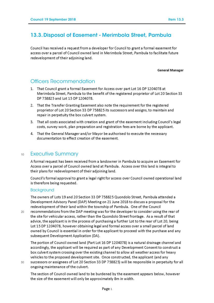
10.2. Disposal of Easement - Merimbola Street, Pambula
This report provides further detail of the proposed disposal of an Easement for Access over a parcel of Council owned land at Merimbola Street, Pambula.
General Manager
|
1. That Council receive and note the report. 2. That Council grant a formal Easement for Access over part Lot 16 DP 1204078 at Merimbola Street, Pambula to the benefit of the registered proprietor of Lot 20 Section 33 DP 758825 and Lot 15 DP 1204078. 3. That the Transfer Granting Easement also note the requirement for the registered proprietor of Lot 20 Section 33 DP 758825 its successors and assigns, to maintain and repair in perpetuity the box culvert system. 4. That all costs associated with creation and grant of the easement including Council’s legal costs, survey work, plan preparation and registration fees are borne by the applicant. 5. That the General Manager and Mayor be authorised to execute the necessary documentation to effect creation of the Easement for Access. |
Executive Summary
Following the Resolution of Council dated 19 September 2018 regarding the proposed disposal of an Easement for Access over Council owned land at Merimbola Street, Pambula further information has been sort and Council’s formal approval to grant a legal right for access over Council owned operational land is therefore being requested.
Background
Council resolved at its Ordinary Meeting of 19 September 2018, when considering the proposed disposal of an Easement for Access at Merimbola Street, Pambula to defer the item for a further report to include items raised in the address to Council and any additional relevant information.
Following the Resolution of Council, officers advised the applicant and their legal representatives that a formal market valuation from an independent registered valuer would need to be obtained to justify the easement being granted for nil compensation.
MVS Valuers were engaged to prepare a formal valuation and compensation payable for the Easement for Access was determined at $15,000 (plus GST). Council officers are requesting Council approval to grant the Easement for Access to the applicant for nil compensation on the following basis:
1. The applicant construct, at their expense, a box culvert system crossing over the existing channel to allow all weather access for heavy vehicles, subject to Council approved plans;
2. The registered proprietor of Lot 20 Section 33 DP 758825, its successors and assignees be responsible in perpetuity for all ongoing maintenance of the culvert;
3. The applicant bare full responsibility for all costs associated with establishing the easement, including any survey works, plan preparation, registration fees and legal costs (including Council’s legal costs capped at $1,500).
Installation of the box culvert system will ensure the development does not burden Council. An appropriately designed box culvert system will also ensure the 1:100 year flood capacity of the existing drainage line is maintained and the existing overgrowth will likely cease to require maintenance by Council.
The MVS Valuer’s report has addressed the issue raised regarding the adjoining land holding potentially being increased in value from the benefit of the Easement for Access. It was noted the Easement for Access will benefit the applicant as it will allow for future expansion of the existing business premises to which it will provide access; however the compensation figure includes any increase in value to the adjoining land.
In addition, the applicant has provided Council a copy of the quotation received from South East Civil and Crane for installation of the box culvert system which is in the vicinity of $110 - $120K.
Options
The options available to Council are:
1. Grant a formal Easement for Access over part Lot 16 DP 1204078 at Merimbola Street, Pambula to the benefit of the registered proprietor of Lot 20 Section 33 DP 758825 and Lot 15 DP 1204078 for nil compensation.
2. Grant a formal Easement for Access over part Lot 16 DP 1204078 at Merimbola Street, Pambula to the benefit of the registered proprietor of Lot 20 Section 33 DP 758825 and Lot 15 DP 1204078 for the compensation amount of $15,000 (plus GST) as determined in the attached MVS Valuers valuation report dated 8 October 2018.
3. Advise the applicant and registered proprietor of Lot 20 Section 33 DP 758825 and Lot 15 DP 1204078 that Council does not agree to grant an Easement for Access over part Lot 16 DP 1204078 at Merimbola Street, Pambula and advise Council officers to continue to maintain the existing drainage line into the future.
Community Engagement
Consultation undertaken
Council officers have been consulting with the applicant and their legal representatives to action the Resolution of Council and will continue to do so until this matter is finalised.
Council consideration of input
Council officers discussed selling the land to the applicants rather than granting an Easement for Access however it was recommended Council retain ownership of the land to maintain control over the floodway. Council acquired the land in 2014 for flood mitigation reasons so Council officers consider it to be in Council’s best interest to retain ownership but grant an Easement for Access requiring the applicant to construct, at their expense, a box culvert system crossing over the existing channel to allow all weather access for heavy vehicles.
Financial and resource considerations
All costs associated with creation and granting of the easement including Council’s legal costs, survey work, plan preparation and registration fees will be borne by the applicant. The applicant will be responsible for all cost associated with installation of the box culvert system which have been estimated the in attached quotation from South East Civil and Crane to be in the vicinity of $110 - $120K.
Compensation achievable for disposal of the Easement for Access is $15,000 (plus GST) however it is suggested Council grant the Easement for Access for nil compensation on the basis the applicant will be responsible for all construction costs, ongoing maintenance and repair in perpetuity of the box culvert system. Installation of the box culvert system which Council does not currently have a budget for will allow Council to cease maintenance of the existing drainage line into the future.
Legal /Policy
The valuation was prepared in accordance with section 55 of the Land Acquisition (Just Terms) Compensation Act 1991 (NSW).
Lot 16 DP 1204078 is classified as ‘operational’ land under section 31 of the Local Government Act 1993, therefore the registration of an Easement for Access is permissible over the parcel of land.
Impacts on Strategic/Operational/Asset Management Plan/Risk
Strategic Alignment
Council’s Acquisition and Disposal of Land Procedure allows for the disposal of land and easements to achieve strategic outcomes and in such situations, best value may comprise financial, environmental or social elements, with a price falling below the “market value” range.
Risk
There are no adverse risks in granting an Easement for Access over Lot 16 DP 1204078 as the processed box culvert system would be subject to Council approved plans.
Attachments
1⇩. Council report - Disposal of Easement - Merimbola Street, Pambula - 19 September 2018
2⇨. MVS Valuers valuation report - Easement for Access Merimbola Street, Pambula (Councillor Only)
3⇨. Quotation from South East Civil & Crane (Councillor Only)
|
Council |
31 October 2018 |
|
Item 10.2 - Attachment 1 |
Council report - Disposal of Easement - Merimbola Street, Pambula - 19 September 2018 |
|
Item 10.3 |
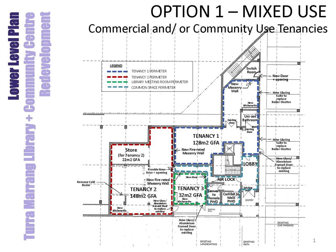
10.3. Tura Marrang Library and Community Centre - Lower level redevelopment and former Managers Residence
This report is presented to seek Council resolution on the redevelopment of the lower level of the Tura Marrang Library and Community Centre and the former Manager’s residence.
Director Community, Environment and Planning
|
1. That Council receive and note the report. Project 1 – Lower level Tura Marrang Library and Community Centre 2. That Council support the redevelopment of the lower level of the Tura Marrang Library and Community Centre into two spaces for tenancies and a hireable meeting room (option b). 3. That Council approve the use of funds from the Public Domains Special Rate Variation currently in reserve to undertake the redevelopment works in conjunction with any grant funds available. 4. That Council call for expressions of interest from organisations and/or businesses to occupy the spaces prior to the redevelopment and that use is based on a financial return to Council. 5. That the General Manager and Mayor be authorised to execute any documentation to facilitate the tenancies. Project 2 – Former manager’s residence 6. That Council call for expressions of interest for the use of the former manager’s residence on the basis of a financial return to Council and that any proposal must meet all planning and building regulation requirements at the cost to the proponent. 7. In the event that no proposals are received, that Council approve the ‘making good’ of the residence for leasing; and appoint a local real estate manager to market the property and lease out for a suitable purpose allowable under the Planning and Building Regulations on the basis of a financial return to Council. 8. That the General Manager and Mayor be authorised to execute any documentation to facilitate the use of the facility in line with Council direction. |
Executive Summary
Council acquired the former Tura Beach Tavern in 2013. The upper area of the Tavern was converted into a library and meeting rooms and opened in July 2016, and is well utilised by the community. Due to the cost of the renovation, the lower level and former manager’s residence were not developed and have remained unoccupied and underutilised.
Council has been approached on a number of occasions by parties interested in using either the lower level or the former manager’s residence however both need work to be fit for purpose. There are also a number of legislative and regulatory requirements that determine the types of use that can be considered.
Councillors have been presented with a range of potential options, their limitations and costs for both spaces, and the purpose of this report is to get direction from Council to enable Officers to proceed with these projects.
Background
Council at its Ordinary Meeting of 16 December 2015 resolved in relation to the conversion of building a library and community facility at Tura Beach:
1. That Council receive and note the report.
2. That Council award tender RFT64/15 for the conversion, renovation and fit-out of the old Tura Beach Tavern into a library and community facility to Edwards Builders Pty Ltd for the lump sum price $996,561 (excl. GST) subject to variations and provisional sums.
3. That unsuccessful tenderers be advised of Council’s decision.
4. That Council authorise the General Manager to execute the relevant contracts and documentation for the project to commence.
This resolution was informed by the funding model put forward in the report, which included:
The revised funding model for this project could use a mix of borrowings, sale of asset and licence, and grant funding. The funding for this project (excl. GST) is as follows:
|
Funding source |
|
Amount |
|
Sale of gaming licences |
$ |
300,000 |
|
Fit-out allocation |
$ |
300,000 |
|
Library Capital Grant from NSW Government |
$ |
200,000 |
|
Proceeds from sale of the residence (former managers house)* |
$ |
300,000 |
* The proceeds from the sale of the residence are an estimate as further work is required to prepare the site for sale.
This is an important consideration in the final determination of a way forward, but it should be noted the sale of the former manager’s residence can occur at any time should Council ultimately not see a return on the property or it becomes a liability. A Planning Assessment has since been undertaken which confirms the former manager’s residence can be subdivided and divested if required.
There has been considerable interest from community based groups, in particular University of the Third Age (U3A) who see great connection between their activities and the library site. Other groups have also shown an interest in utilising the buildings.
A number of options have been presented to Councillors previously and are outlined in the Options section below.
Options
This report includes two projects on one site:
The options for the lower level of the Library and Community Centre are:
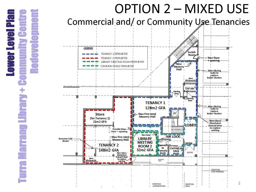
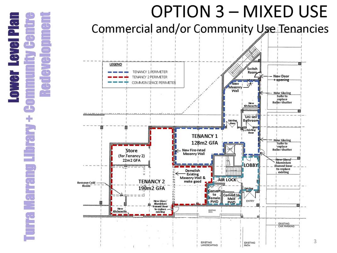
· Redevelop the lower level into a number of distinct rooms that can be leased out for a financial return as outlined in the attached plans:
a. Three spaces for tenancies; or
b. Two spaces for tenancies and a hireable meeting room; (Officer recommendation) or
c. Two tenancies.
Any of the above options will require Development Consent and Construction Certificate to proceed.
· Do nothing and continue to use the space for storage of excess goods and equipment.
· As the population and needs of this community continue to grow, doing nothing to this potentially valuable community space is not a viable option.
The options for the former manager’s residence are:
The options for the former manager’s residence are less straight forward as some options would require works and/or additions to the building to ensure compliance with current legislation and regulations. The recommendation being put to Council is to call for expressions of interest in the building and lease on a commercial basis, whereby any costs to meet Development Consent and regulatory requirements will be borne by the lessee.
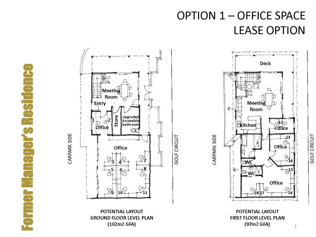
Option 1 – Office Space Leasing
· This option potentially has the greatest viability for financial return however would still require some ‘make good’ of the garage area of the building. A long term tenant may wish to invest in the upgrades required.
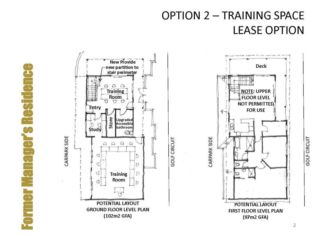
Option 2 – Training Space Leasing
· Without the installation of a lift required under Regulation, this option limits the use of the building to the lower level of the residence, thus minimising the value and potential return to a lessee. A long term tenant may wish to invest in the upgrades required.
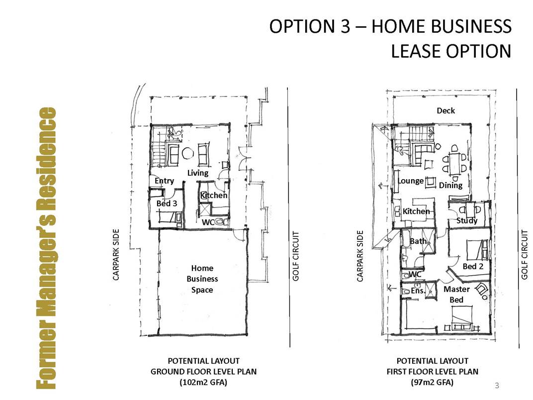
Option 3 – Home Business Leasing
· This would require Development Consent, but is permissible in the zone.
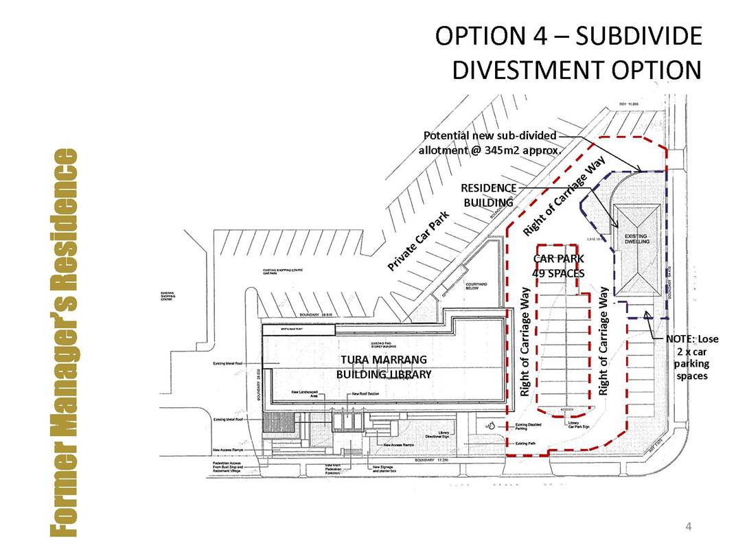
Option 4 – Subdivide and Divest
· In line with the December 2015 report, this is an option and is permissible under current Planning requirements. There would be costs associated with the divestment that would ultimately reduce the return to Council.
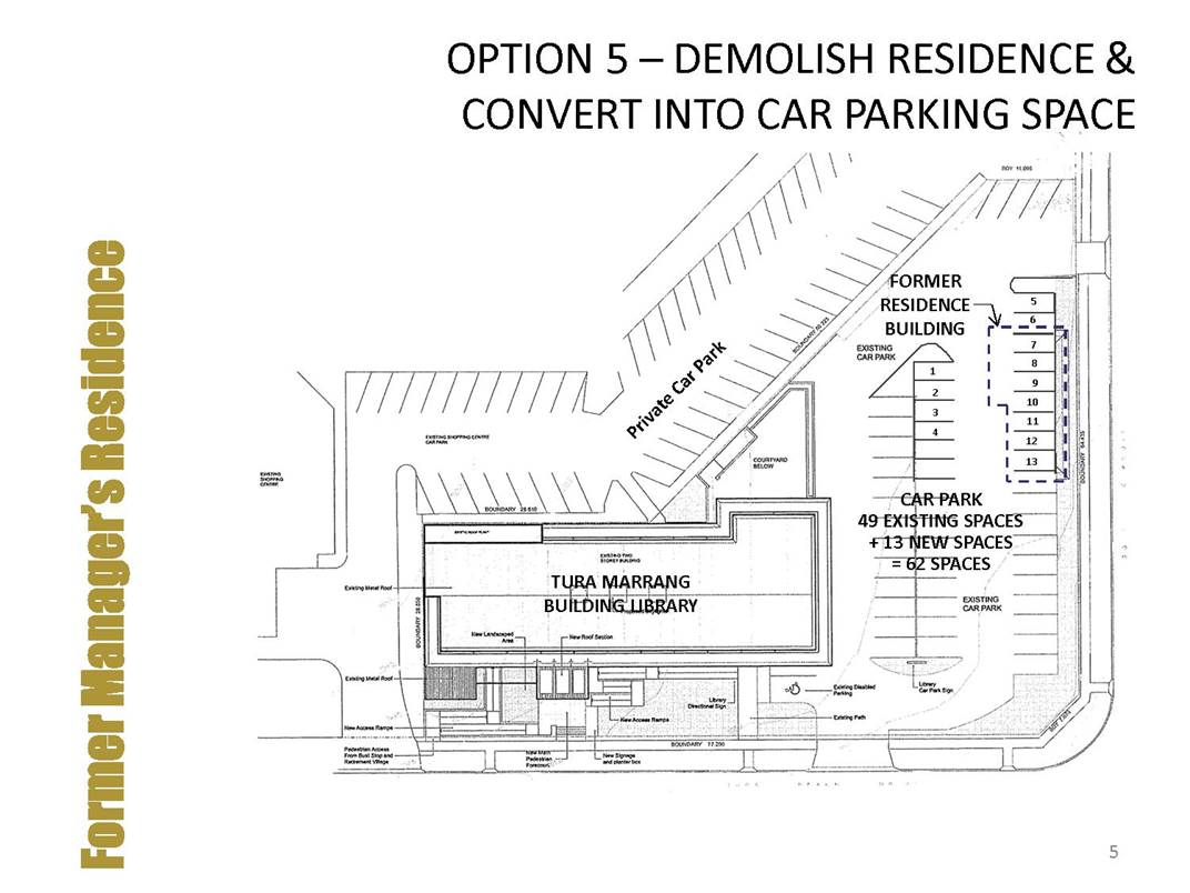
Option 5 - Demolish Residence and Covert to Car Park
· This option ultimately ends up costing Council significantly to deliver a small increase in parking capacity, at the loss of ongoing financial return.
Community Engagement
Consultation undertaken
There has been interest and conversations held with a number of community groups on the opportunities presented by these properties. The former manager’s residence has also been raised through the Affordable Housing Roundtable as a potential social housing option.
Consultation Planned
Officers are recommending an expression of interest process, which will give community groups and businesses the opportunity to submit proposals for Council’s consideration.
Council consideration of input
Council considered a number of reports on the purchase and redevelopment of the former Tura Beach Tavern and has received a number of briefings since that time on how to best utilise the lower level and former manager’s residence.
Financial and resource considerations
Both the lower level of the Tura Marrang Library and Community Centre and former manager’s residence need work to be fit for purpose. That investment needs to be made by either Council or a tenant. Depending on the use, Council may be able to access grant funding to assist in the redevelopment of the lower level. Council also has a Special Rate Variation (SRV) called Public Domains, which was put in place to assist with the maintenance and renewal of public building assets. There are currently funds in reserve that could be used to undertake these works.
In relation to the lower level redevelopment, it is expected approximately $250k would be required to make the spaces fit for purpose. This is indicative only and would need to be tested in the market place to confirm. Depending on the tenancies that are ultimately taken up, the income from those tenancies could be used to offset the funds used from the Public Domains Reserve, essentially allowing for investment back into buildings that do not make a financial return to Council (which is most of them).
There are potential funding opportunities which should be pursued to assist with this project and any successful grant would reduce the draw on the Public Domain SRV.
|
Funding source |
|
Amount |
|
Public Domains SRV |
$ |
250,000 |
Legal /Policy
The former tavern land was purchased by Council and is classed as Operational land, which allows Council to divest or lease as it requires.
Impacts on Strategic/Operational/Asset Management Plan/Risk
Strategic Alignment
Goal 4: We have meaningful employment and learning opportunities for people in all stages in life.
12: Our Council is financially sustainable and services and facilities meet community need.
Risk
The reputational and financial risk of doing nothing is great with this site as it has been sitting underutilised for some time. Unlocking its potential to raise funds that can be invested into other areas of Council business provides a win-win.
Attachments
1⇩. Lower level Tura Marrang Library and Community Centre Options
2⇨. Lower level Tura Marrang Library and Community Centre cost benefit analysis (Councillor Only)
3⇩. Former manager’s residence options
4⇨. Former manager’s residence cost benefit analysis (Councillor Only)
|
Council |
31 October 2018 |
|
Item 10.3 - Attachment 1 |
Lower level Tura Marrang Library and Community Centre Options |
Council |
31 October 2018 |
11.1 Former Hotel Australasia ....................................................................... 126
11.2 Sapphire Coast Tourism Wind Up.......................................................... 129
|
Council 31 October 2018 |
Item 11.1 |
11.1. Former Hotel Australasia
This report details the results of the Request for Quotation (RFQ) process and the Expression of Interest (EOI) process recently carried out for the proposed sale, restoration and use of 142 – 144 Imlay Street, Eden (former Hotel Australasia).
Director Community, Environment and Planning
|
1. That Council receive and note the report. 2. That Council note the Request for Quotation (RFQ) process from the three (3) locally based Eden Real Estate Agents to represent Council to market and sell the former Hotel Australasia has now closed. 3. That Council note the Expression of Interest (EOI) process for person/s or groups to enter into a Contract for Sale and Side Deed for the sale, restoration and use of the former Hotel Australasia has now closed. 4. That Council consider the Council officers’ recommendation as detailed in the attached Confidential Report and resolve accordingly. [Insert recommendation option 1 or 2] 5. That Council delegate authority to the General Manager to continue to negotiate a sale of 142 – 144 Imlay Street, Eden (former Hotel Australasia) for a minimum value as determined by Council. 6. That Council hereby authorise its Official Seal to be affixed to the contract documents under the signature of the Mayor and General Manager. |
Executive Summary
This report details the evaluation of tenders received in response to the Request for Quotation (RFQ) for invitations to represent, Bega Valley Shire Council (BVSC), as agent in the marketing and sale of 142 – 144 Imlay Street, Eden (Hotel Australasia).
The report also details the results of the Expression of Interest (EOI) process for persons or groups to enter into a Contract for Sale and Side Deed for the sale, restoration and use of 142 – 144 Imlay Street, Eden (Hotel Australasia).
Background
Council resolved at its Ordinary Meeting of 8 August 2018, when considering its position on the sale of 142 – 144 Imlay Street, Eden (Hotel Australasia) to engage the three (3) locally based Real Estate Agents in Eden to provide detailed marketing plans to Council including costings, related to commissions and expected expenses. As such, Council officers wrote to the three (3) Agents inviting them to make an RFQ submission for the delivery of these services.
As a result of the RFQ process, Council received submissions from all three (3) locally based Eden Real Estate Agents which are attached for the information of Councillors.
At Council’s Ordinary Meeting of 19 September 2018, a Mayoral Minute seeking to substitute the Resolution of 8 August 2018 was received. The Mayoral Minute altered Council’s Resolution of 8 August 2018 to include an additional recommendation requesting expressions of interest from person/s or groups have that an interest in purchasing Hotel Australasia, including any proposal that may be a public private partnership. Following the Resolution of Council, an expression of interest advertisement was placed in all local newspapers with a closing date of 17 October 2018.
Options
The options available to Council are:
1. Continue to proceed with the sale of the property and accept the recommendation provided by Council officers in the attached recommendation report and resolve accordingly. A further report to Council would be required to finalise the details of the sale conditions and detailed approach.
2. Decline to accept the RFQ submissions received from the three (3) locally based Eden Real Estate Agents and advise all tenders of Council decision.
3. Consider proposals received via the EOI process.
4. That 142 – 144 Imlay Street, Eden (Hotel Australasia) remains in Council ownership. Note: maintaining ownership of the property will require the identification of funds to undertake necessary works on the building and ongoing maintenance and operational budgets. A revised Business Plan on the use of the building and community engagement would also be required.
5. Other options, as raised and resolved by Councillors.
Community Engagement
Consultation undertaken
Council officers wrote to the three (3) locally based Eden Real Estate Agents inviting them to provide an RFQ submission, allowing a period of 21 days for the submission to be received.
Council also advertised in the public notices section of all local newspapers calling for EOI for person/s or groups for the purchase of 142 – 144 Imlay Street, Eden with a closing date of 17 October 2018 as per the Resolution of Council.
Council consideration of input
There has been significant consideration by Council officers on this matter. The Local Government Regulations (Tendering Guidelines for NSW Local Government – October 2009) are very clear on the process for accepting, declining and negotiating during and after a tender process. These Guidelines have been followed to date. Given all tenders previously run have been rejected by Council, the tendering process is over and Council is now in a separate process of direct negotiation.
Financial and resource considerations
All options will have additional financial and resource implications. To date officers have not had time to explore the implications in detail, and this will occur following direction of Council being resolved on the adopted approach.
Sale options will include additional officers' time and resources as well as the possible engagement of third parties, advertising, marketing, and legal costs. The attached RFQ submissions from the three (3) locally based Real Estate Agents detail costs associated with their service as does the officer’s recommendation report.
To maintain ownership will require Business Plan preparation, officers' time and resources, capital expenditure and ongoing operational and maintenance budgets to be sourced. This option may result in an income stream being generated in the future depending on usage. costs involved in the proposed disposal of land will be offset against the proceeds of sale.
Legal /Policy
The RFT process complied with Local Government (General) Regulation 2005 (NSW) and Bega Valley Shire Council Policies. Advice from Council’s legal representatives was obtained in relation to whether there were any issues with the two processes for obtaining proposals for the marking and sale of the site occurring in tandem. The advice received was that the business can be brought to the Council in a Mayoral Minute and the Motion can be put to the Council meeting without a seconder.
Clause 243 of the Local Government (General) Regulation 2005 (NSW) allows the Mayor, if the Mayor is the chairperson at a meeting, to put to the meeting without notice a minute signed by the Mayor on any matter or topic that is within the jurisdiction of the Council.
Impacts on Strategic/Operational/Asset Management Plan/Risk
Strategic Alignment
Outcome 4: Liveable Places; Goal 8: Our places retain their character and scale, development is well planned, and a range of goods and services are available within out Shire that meets local needs.
Risk
In determining its direction, Council should consider a number of risks associated with this matter including but not limited to:
· Reputational risk in relation to the length of time taken on this matter, and the community's view on how Council is handling the matter;
· Financial risk in relation to the ongoing liabilities related to building management whilst in Council ownership; the cost of undertaking the sale process; and future costs to undertake major works, should the building stay in Council ownership;
· Risk in relation to the sale to a vendor who may or may not have the capacity and/or capability to complete the project; and the building remaining in a state of disrepair into the foreseeable future.
These risks are inherent in the project, but can be mitigated by making timely decisions.
Attachments
1⇨. RFQ EOI Recommendation Report (Councillor Only)
|
Council 31 October 2018 |
Item 11.2 |
11.2. Sapphire Coast Tourism Wind Up
Sapphire Coast Tourism (SCT) has been formally wound up as an entity, after many successful years building the Shire’s tourism profile and offering.
Director Business and Governance
|
1. Council note and recognise the contribution that Sapphire Coast Tourism Board and staff have made in growing the visitor economy in the Bega Valley Shire. 2. Council note that Sapphire Coast Tourism has been wound up by its membership, with remaining funds disbursed to the membership based Visitor Information Centres. |
Executive Summary
Sapphire Coast Tourism (SCT) was established in 2008 by Bega Valley Shire Council (BVSC) to deliver tourism services and maximise the potential of tourism, to contribute to the social and economic wellbeing of the local community. SCT delivered its services with the financial support of BVSC and government grants when achieved.
SCT have driven the destination management planning of the Shire and successfully helped position the Sapphire Coast as Australia’s Coastal Wilderness – our unique selling point to domestic and international markets.
A useful measure of SCT’s performance is the Destination NSW local government tourism statistics. The latest 5 year rolling average, shows Bega Valley’s annual change in visitor nights since 2013 is 5.03% which is well above the figure for comparable shires, and the annual average change in actual dollars spent is 12.24%, again well above comparable areas.
During its operation SCT achieved many outcomes including:
· Provided leadership to bring town tourism bodies together in a spirit of collaboration after a long period of instability.
· Established deep and successful relationships with regional tourism organisations including: visit Canberra; Sydney-Melbourne Touring Route; Destination NSW; Tourism Australia; amongst many others.
· Provided a caretaker role for the Merimbula Visitor Information Centre before a successful handover to a local community group.
· Provided representation and leadership to the Tourism, Australia National Landscape project to ensure the region was selected as one of 12 of Australia’s National Landscapes.
· Developed the Australia’s Coastal Wilderness Experience Development Strategy which continues to inform the region’s experience development.
· Developed the Sapphire Coast Brand Toolkit to guide nature based experience and product development.
· Developed the Sapphire Coast Digital Strategy to encourage key towns to participate in shared digital content websites, including implementing the highly regarded social media program.
· Secured grant funding to develop the Sapphire Coast Tourism Heritage Strategy.
· Produced the ‘Journeys’ project, raising funds from neighbouring LGA's to further develop Sapphire Coast Heritage stories including the development of a range of visitor brochures and digital material.
· Attracted one of the largest tourism industry development grants through the Regional Jobs Investment Program – Tourism Future 2030.
· Secured grant funding to develop interpretative project 'Killer Whale Trail'. A trail connecting key whale heritage sites using interpretive signage and digital channels.
· Supported an emerging cruise industry in Eden, ‘Cruise Eden’, which has now seen a combined federal, state and local government investment of over $50m. This support also extended to the development of key strategies, particularly in return visitor and shore development, ensuring how the Shire could best leverage the wharf investment opportunity.
· Secured funding from Port Authority of NSW to provide project management resource for Cruise Eden project.
· Developed South Coast membership and representation on the Management Committee of Sydney Melbourne Touring.
· Secure grant funding to develop the Tourism Future 14 program, inspiring new experiences and products into the market
· Produced the Sapphire Coast Film, with content delivering over 60,000 film views.
· Grew international trade product from four to sixteen.
· Developed and led the #Canberrascoast initiative, to leverage Canberra International Flights, including partnering Visit Canberra on sales missions to Singapore and Malaysia on two occasions.
· Rallied a team of local ‘foodies’ to share a vision and create the first local food festival in the region, EAT Merimbula.
These achievements are significant for an organisation with a volunteer Board and limited staff.
With the Local Government Act 1993, requirement for Council to go to tender for tourism marketing services, the SCT Board considered this specified funding level meant that it would be unable to deliver the key programs set out in the tender specifications and SCT Constitution. In the absence of additional funding, SCT believed it was unable to continue trading and the Board decided to commence the process of winding up the company.
All formal processes of winding up SCT are now complete with Kothes Accounting Group finalising the financial statements.
Financial and resource considerations
The SCT Board resolved to voluntarily de-register the company. Once all other financial commitments were met, SCT was left with a small cash holding to the value of $29,783.88. The SCT Board determined the most appropriate way of distributing the last remaining cash assets would be to disburse them to the region’s member based Visitor Information Centres (VIC) so that these funds may be used to continue to promote tourism in the Shire.
In order to provide a fair and equitable distribution, the board of SCT decided to disburse the final cash holdings along the lines of the number of members each VIC holds. That distribution is:
· Merimbula: $10,722.20
· Eden: $7,743.81
· Bermagui: $6,850.29
· Tathra: $4,467.58
Legal /Policy
SCT was a limited Company, separate from BVSC and was required to follow the requirements of the Corporations Act 2001 (Cth) (the Act). To ensure the requirements of the Act were met, SCT engaged Kategic Solutions and Kothes Chartered Accountants to formalise and finalise all due diligence requirements with regards to closing the business.
An Annual General Meeting was held on 24 September 2018 and at this meeting SCT members unanimously voted to voluntarily deregister the Company.
Attachments
Nil
Council |
31 October 2018 |
12.1 Bega Valley Shire Transport Futures: A Vision Document..................... 134
12.2 Sportsground Water Use......................................................................... 151
12.3 Merimbula Airport Leases....................................................................... 171
12.4 Mirador Emergency (Secondary) Access................................................. 178
12.5 Draft Revised Short Point Coastal Access Masterplan........................... 206
12.6 Management and Operation of Merimbula Airport.............................. 221
12.7 Site Management Plan - Tura Head Coastal Reserve (The Point) and Dolphin Cove Reserve.............................................................................. 225
|
Council 31 October 2018 |
Item 12.1 |
12.1. Bega Valley Shire Transport Futures: A Vision Document
The Bega Valley Shire Council Transport Futures vision document has been developed to articulate the Council’s long-term aspirations for the transport network.
Director Assets and Operations
|
1. That the Bega Valley Shire Transport Futures vision document be placed on public display and consultation for 3 months. 2. That the results of the consultation be reported to Council. |
Executive Summary
The Bega Valley Shire Council Transport Futures vision has been developed to articulate the Council’s long-term aspirations for the transport network. The vision is descriptive and it is acknowledged there are many influences outside the control of the Bega Valley Shire Council that will ultimately determine whether this vision is realised. However, the broad vision provides direction for the outcomes and strategies on which the Council will focus. It is necessary to have a vision of the future we want, so we can address challenges as they arise and meet our economic, social and environmental goals.
Council has engaged Bitzios Consulting, a leading specialist traffic engineering and transport planning consultancy, to undertake this body of work. Bitzios Consulting has submitted the attached draft Transport Futures vision document (Attachment 1) for consideration by Council.
Background
The Bega Valley Shire Council (Council) is developing a comprehensive transport strategy for the South Coast that takes into account the natural, social, cultural, and commercial environment, as well as recognising all modes of transport and their interdependencies. This study is required to provide a future transport planning framework that will improve quality of service, support economic growth and regional development and enhance local accessibility in a sustainable, liveable, safe, and secure way. It is important Council has a comprehensive knowledge of the strengths, weaknesses, opportunities, and challenges unique to the Bega Valley Shire.
Good planning governance states strategies should be designed to cascade into increasing levels of detail, to ensure high level aspirations eventually result in some form of measurable action.
That is, the objective and vision are the first step – the broad directional statements. The strategies are the second step – where the objectives start to take on more shape, how the objectives will be achieved and which areas need to be focused on.
Ultimately, the strategies will cascade down into the Delivery Program and Action Plan where they will be fleshed out with more specific timeframes and responsibilities added, and finally into the Operational Plan, programmes and Long Term Financial Plan.
This process is expected to take many years to complete over a number of phases.
Vision and strategic documents are necessary for the management of Bega Valley Shire's transport network and complement Council's Asset Management Plans. Not only do they provide guidance and determine outcomes but are essential for competent, informed, and cost effective asset management. Strategic plans are also required when applying for grant funding as it shows the requested funds are spent in line with the community priorities and long-term direction.
Community Engagement
Consultation undertaken
There was consultation undertaken in June 2017 with key businesses in Bega Valley Shire by a panel comprising Council officers: Jason Deller, Manager of Strategy and Asset Services; Peter Newton, Forward Planning Coordinator; and Steve Brooks, Bitzios Consultancy. The feedback was recorded and incorporated into the Transport Futures vision document.
Council consideration of input
The next steps for the adoption and implementation of the Bega Valley Transport Futures vision document are:
· Place on public display and engage with the community
· Review and consider the community feedback
· Incorporate the feedback and finalise the draft vision document
· The document, Transport Futures, is presented to Council for adoption
· Council officers then proceed with the development of detailed strategies and action plans over the 2018-20 financial years (dependent on budget allocation).
Financial and resource considerations
Bega Valley Transport Futures is a draft vision document outlining the direction Council will take once adopted, for safe and effective transport management. Whilst, there are no financial considerations to assess in this Council report, the draft vision document will ultimately shape how the transport budget is spent in future years and has the potential to impact on the Long Term Financial Plan. There are also considerable financial and resource considerations for the progression of Bega Valley Transport Futures into strategic and action plans.
Impacts on Strategic/Operational/Asset Management Plan/Risk
Strategic Alignment
The Bega Valley Transport Futures vision document will fulfil Council's Community Strategic Plan (CSP) under the following elements of ‘an accessible place’ and set the future direction for:
· Creating a resilient road network
· Effective road management
· Building an active transport network
· Increased parking management
· Port and Airport investment
Environmental / Sustainability
The Bega Valley Transport Futures vision document will also fulfil Council’s Community Strategic Plan (CSP) under the following elements of ‘a sustainable place’ and set the future direction for:
· New technologies that will improve emissions
· Potential electric vehicle recharge sites
· Focus on reducing communities’ reliance on cars for transport within and between urban centres.
Economic
Without adequate planning and funding, Bega Valley Shire will miss out on the enormous economic opportunities emerging in the area. This vision is the start of the process to realise these opportunities and strengths. Without a vision, there is a potential for missed opportunities and unclear direction which may lead to reduced road safety, transport choice, and amenities for its residents and visitors.Additionally, external funding is critical with rate payer based funding insufficient to continue to invest in the emerging economic stimulus opportunities in the transport network. The application for external funding requires Council to show how the applied funds will help achieve the outcomes outlined in their vision and strategic plans. It is therefore an economic benefit to invest in the development of the vision and strategic plans.
Attachments
1⇩. Consultation Draft Bega Valley Shire Transport Vision FINAL
|
Council |
31 October 2018 |
|
Item 12.1 - Attachment 1 |
Consultation Draft Bega Valley Shire Transport Vision FINAL |
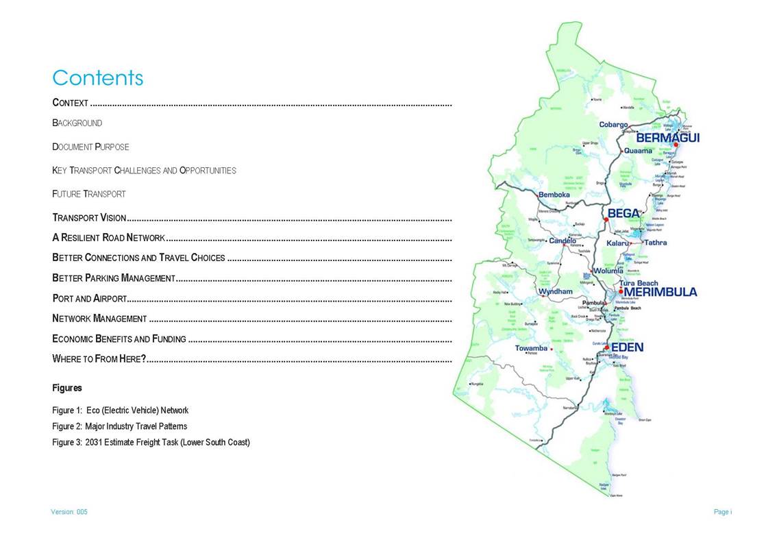
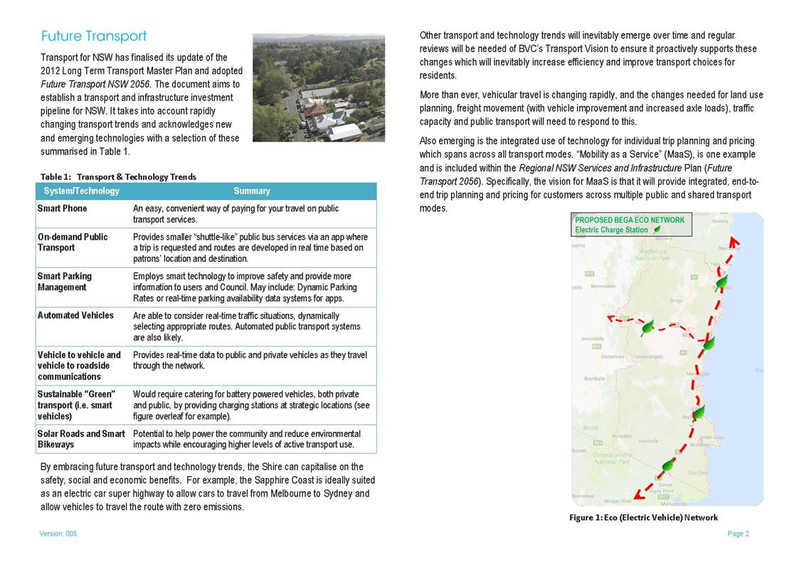
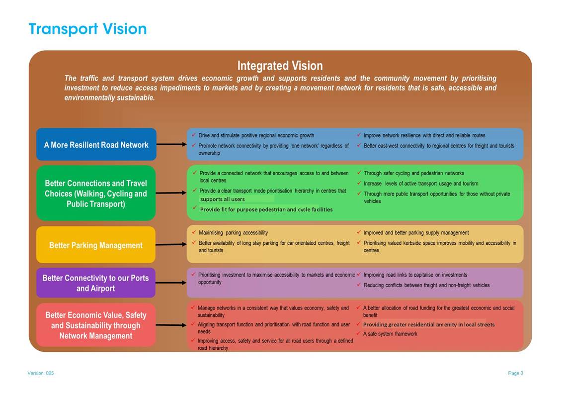
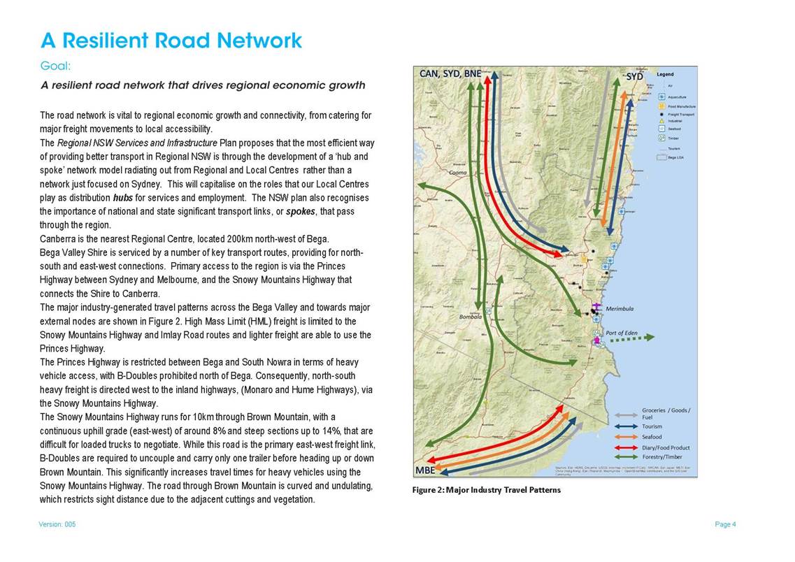
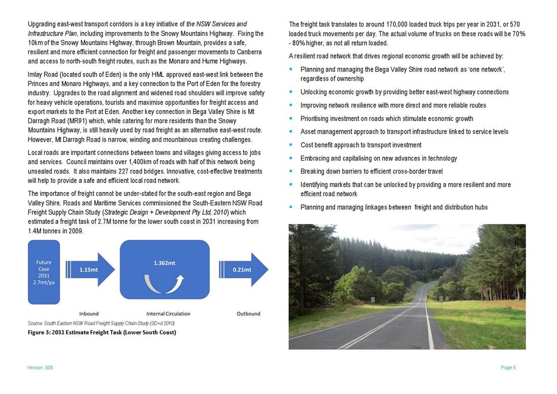
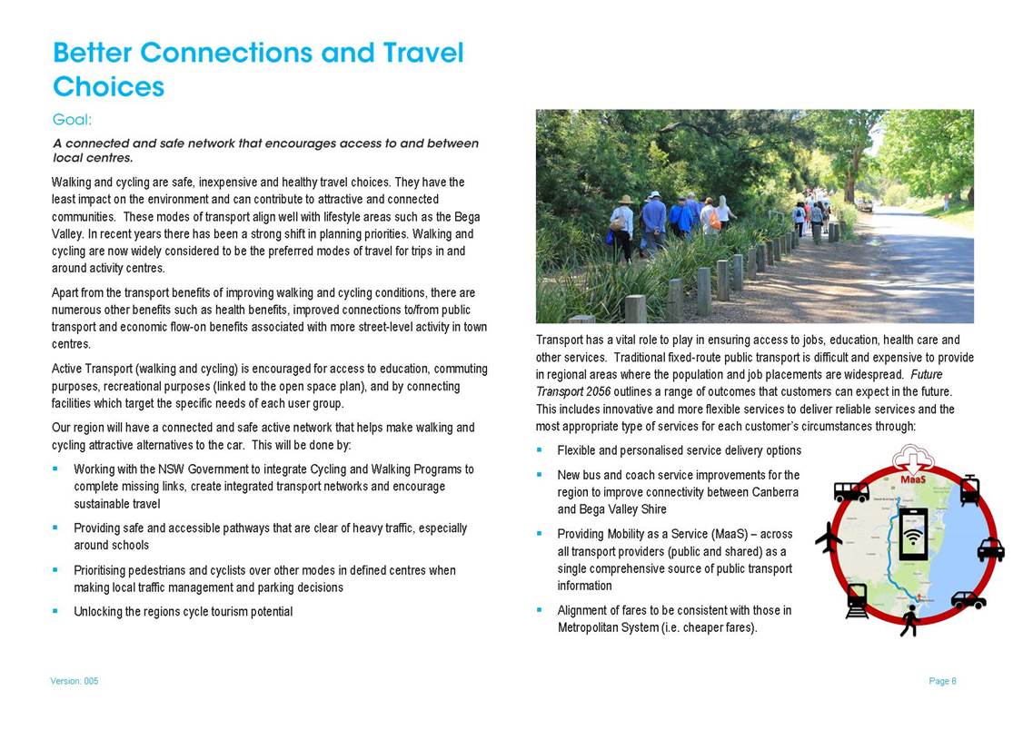
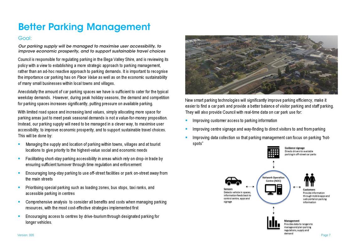
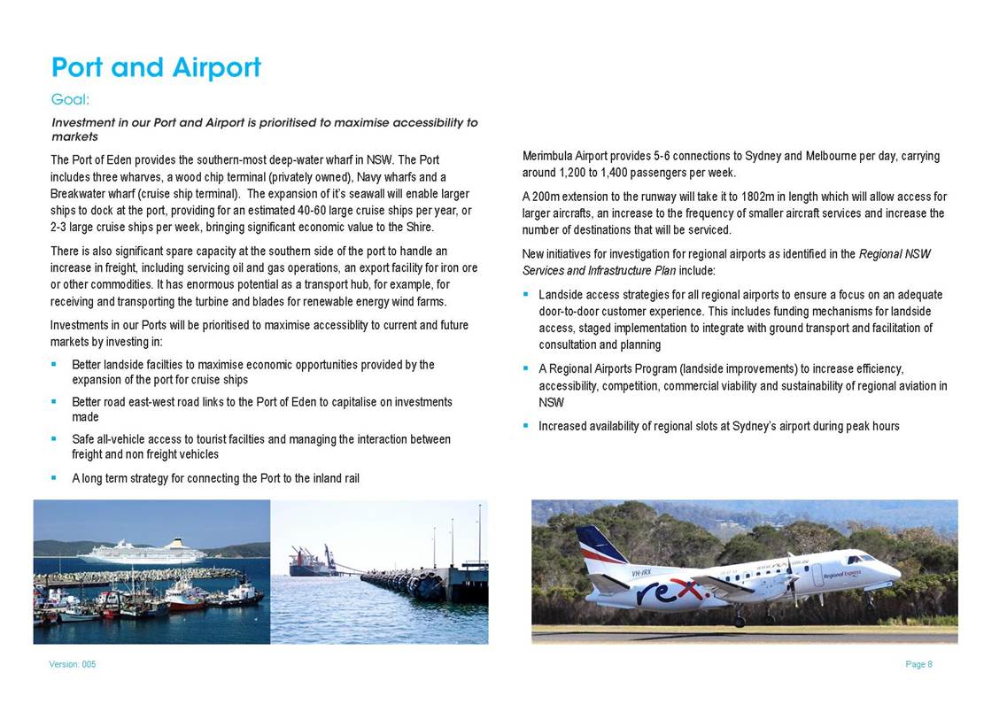
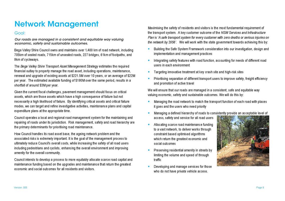
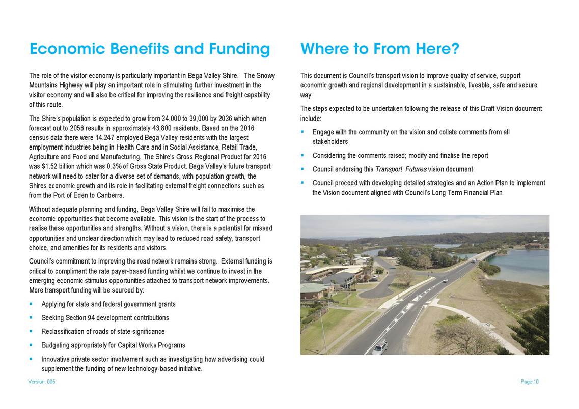
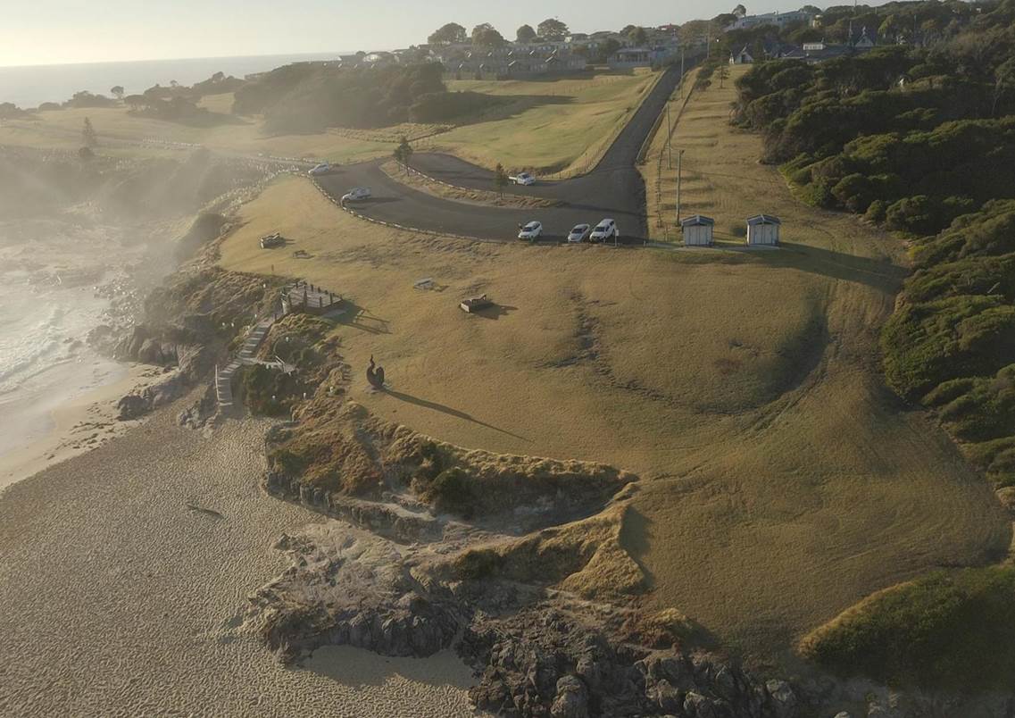
|
Item 12.2 |
This report provides history, current situation, current issues and future recommendations regarding water use at Sportsgrounds including a summary of water use allocations, cost implications, outstanding water accounts and draft irrigation management plan.
Director Assets and Operations
|
1. That Council adopt the draft Irrigation Management Plan attached to this report and the annual oval irrigation water volume allocations as recommended in Table 2 of this report. 2. That future irrigation overuse is accounted for through reduced operations and maintenance programs; or water allocation shortfalls are funded directly by revenue raised by site committees. 3. That Council request information from the site committees at Pambula Sporting Complex, Lawrence Park Tathra and George Brown Memorial Sportsground Eden in regard to historical irrigation management and water use, and for those committees to provide options and proposals that will address outstanding water charges at those sites. |
Executive Summary
This report provides a history of the water allocations to sportsgrounds. It also provides a summary of the current practice and future recommendations of water use allocations as well as current outstanding accounts.
Background
Water allocations at George Brown Oval, Pambula Sports Complex, Berrambool Sporting Complex, Lawrence Park and Dickinson Oval were introduced in 2007 to encourage understanding of water use, accountability and more efficient use of water for ovals’ irrigation. At that time an allocation was made in the form of cash payment from Council to site committees. The view was that if more water than the allowance was used, the difference would be met by the committee. If users under spent, the balance (being in cash) would be able to be allocated to maintenance and upkeep of the facility at the committees’ discretion.
Over the period between 2007 and 2013, circumstances changed with water access charges no longer being applied to Council properties (resulting in increased funds available to those site committees for maintenance), higher than average rainfall, the installation of irrigation systems and the rearrangement of water meters to reduce the sewer discharge factor and associated charges, resulting in the proposal considered in 2013. Further background information is attached in the copy of the report to the 4 September 2013 Council meeting.
In that report a proposal was put to Council where Council resolved to provide a fixed amount of water per financial year, based on volume per hectare, and any amounts above and beyond this allowance to be payable by the responsible sportsground site committee.
Council Resolved:
1. That Council allocate a fixed ‘free’ volume of water as per the table set out below and based on the weighted average usage over the past three years, at George Brown Oval, Pambula Sports Complex, Berrambool Oval, Lawrence Park and Dickinson Park.
2. Any requests for an increase above the allocated amount are supported with a Water Usage Plan endorsed by a professionally qualified expert in the maintenance of sporting fields.
The water notices were still issued showing the credit brought forward, the usage and the balance of the account, enabling the committee to monitor their usage throughout the financial year and aimed to reduce ‘over usage’.
If the committee had a large debt carried forward, the allowance could reduce the amount outstanding but the debt was to be paid from the sporting committee’s own funds raised through venue hire, ground fees etc. This was outlined in a letter after the Council Resolution from Director Transport and Utilities dated 29 January 2014, and sent out each year when the allocations made (copy attached).
It seems at that time there was little accountably for over use of water and the likely increase in operational costs at the site/s resulting from the overuse. In effect, the intent of the Resolution was to identify water as a community resource (as opposed to funding) and endeavour to manage it by volume. Overuse would incur water use fees and any unused water would not be bought forward as credits. If there was an unused water resource (i.e. as a result of higher than average rainfall or improved water penetration and availability within the soil as a result of improved maintenance practices) it would not be bought forward. At sites where there was outstanding water accounts, surplus could be used to reduce the account balance. In effect this means that water credits could be used to offset a water account cash debt.
The allowance was based on the size of the ground and was outlined in kL in the Council Resolution of September 2013 as follows:
|
Sporting Oval |
Current average Kl/Ha = mm/m2 |
Revised Kl/Ha = mm/m2 |
Water Allocation Kl/Pa |
|
George Brown Memorial Sportsground |
207mm |
247mm |
3,705 |
|
Dickinson Park |
160mm |
247mm |
3,730 |
|
Pambula Beach Sporting Complex |
417mm |
247mm |
5,335 |
|
Berrambool Sporting Complex |
121.6mm |
247mm |
8,175 |
|
Lawrence Park |
445mm |
247mm |
2,964 |
|
|
23,909 |
||
Table 1: 2013 Sports Oval Irrigation Volumes
Further calculations can be found in the attachment 11.3 Water Allocation Payments to Sportsground Committee (attachment).
At that time the 6 remaining sportsgrounds (Bega Recreation Ground, Bemboka Colombo Park, Candelo John Gordon Recreational Reserve, Eden Barclay Street, Wyndham and Wolumla Recreation Ground were not included in that program and to date have had water usage paid directly by Council through a Work Order to assign and monitor costs by site.
In 2016 Bega Valley Shire Council commissioned AgEnviro to complete a Sports Oval Ground Condition assessment. The report included a review of irrigation systems and recommended annual irrigation requirements (by volume). The recommendations of that report are:
|
Site |
|
Area Ha. |
Volume Kl pa (Ag enviro, inc rainfall) |
Annual rainfall Kl |
Volume Kl pa (BVSC) |
|
George Brown Memorial Sportsground |
1.5 Ovals |
2.0 |
5960 |
1365 |
4595 |
|
Dickinson Park Bermagui |
1 Oval |
1.5 |
3648 |
1057 |
2591 |
|
Pambula Beach Sporting Complex |
2 Ovals |
2.8 |
8080 |
1960 |
6120 |
|
Berrambool Sporting Complex |
2 Ovals |
2.8 |
8080 |
1960 |
6120 |
|
Lawrence Park |
1 Oval |
1.3 |
2708 |
910 |
1798 |
|
Bega Sports Grounds |
2 Ovals |
2.3 |
6182 |
1610 |
4572 |
|
Colombo Park Bemboka |
1 Oval |
0.9 |
3008 |
595 |
2413 |
|
John Gordon Recreational Reserve Candelo |
1 Oval (manual) |
1.1 |
2253 |
756 |
1497 |
|
Barclay Street Sporting Complex Eden |
2 Ovals (manual) |
2.8 |
2444 |
1960 |
484 |
|
Wolumla Recreation Ground |
1 Oval (tank) |
1.2 |
450 |
840 |
450 |
|
Valley Fields |
2 Ovals (manual) |
3.6 |
2500 |
2520 |
0 |
|
Wyndham Recreation Ground |
1 Oval (licence) |
1.0 |
0 |
700 |
0 |
|
Total |
17 Ovals |
23.2 |
|
|
30640 |
|
Based on AgEnviro 2016 report for irrigation water usage |
|||||
|
Candelo & Barclay Street based on average usage for last 3 years. |
|||||
|
Wyndham has a licence to obtain water from Myrtle Creek |
|||||
|
Annual rainfall average 700mm |
|||||
Table 2: Recommended Annual Irrigation Requirements
An audit of irrigation systems was undertaken earlier in 2018. Maintenance works resulting from the audit have been completed. An Irrigation Management Report was developed using the information from the 2016 AgEnviro Solutions report, and available funds. This Irrigation Management Report was forwarded to the S355 General Sportsground Committee and discussed as an agenda item at 20 August 2018 Meeting. The intent of the report is to continue to make improvements to the management and use of water as one of the key resources that contribute to the overall condition of sports ovals across the Shire and see the best and most efficient use from irrigation systems. The report includes a nominated representative from each site to assist where changes to irrigation times/duration are required.
Financial and resource considerations
Water use for irrigation at ovals is a significant cost in operating sports ovals. Currently the budget for water use at sportsgrounds is $97,800 per year. Over water use is accounted for against the site and in effect should reduce the resources available for other ovals operations and maintenance works. Currently as of 16 October 2018, there are outstanding water accounts at Lawrence Park ($32,142.67), Pambula Beach Sporting Complex ($140,025.95) and Eden George Brown Memorial Sportsground ($14,240.51) that need to be addressed. Note that sewer charges are included in those amounts as they are included in the accounts.
Options
To move forward in continuing to make improvements in irrigation management at sports ovals across the Shire there are two items to be resolved, being: adoption of a shire wide sports ovals irrigation management plan; and how to address the matter of outstanding water accounts. Options for both are presented below.
Options for Shire Wide Sports Ovals Irrigation Management Plan:
1. That Council adopt the draft irrigation management plan attached to the report and the annual oval irrigation water volumes as recommended in the Table 2 of this report. Future overuse is accounted for through reduced operations and maintenance programs or shortfalls are funded directly by site committees.
2. Remain as is with water volumes applied to George Brown Sporting Complex, Berrambool Sporting Complex, Dickinson Oval, Pambula Beach Sporting Complex and Lawrence Park and the remaining ovals be on as used basis. This option has resulted in limited accountability for over use to date and would require monitoring to determine water usage to ensure budgets are not exceeded.
3. All sportsground water usage charges are paid under a Work Order with no set allowance amount. This would result in very limited accountability for over use of the community’s water resources.
Maintenance programs work in tandem with irrigation programs to get the best efficiency out of water use and improved grounds conditions. In effect over use results in less funds being available for ovals maintenance and improvement programs.
Options to address outstanding water accounts at Lawrence Park ($32,142.67), Pambula Beach Sporting Complex ($140,025.95) and Eden George Brown Memorial Sportsground ($14,240.51) are:
1. That Council request information from the site committees at Lawrence Park Tathra, Pambula Sporting Complex, and George Brown Memorial Sportsground Eden in regard to historical irrigation management and water use and recommendations or proposals from those committees on options to address outstanding water charges at those sites.
2. Sportsground site committees being held responsible to pay outstanding accounts with the relevant committees to provide a strategy to progressively reduce current debts.
3. Council clearing the debt.
Attachments
1⇩. Council Report No 11.3 Water Allocation Payments to Sportsground Committees 04/09/2013
2⇩. Water Allocation Letter 40027808 Pambula Beach Sporting Complex 40198861 Berrambool Sporting Complex 40062010 Lawrence Park Tathra 40115334
3⇩. DRAFT Irrigation Management Plan October 2018
|
Council |
31 October 2018 |
|
Item 12.2 - Attachment 1 |
Council Report No 11.3 Water Allocation Payments to Sportsground Committees 04/09/2013 |
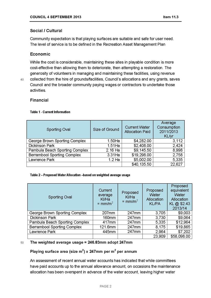
|
31 October 2018 |
|
|
Item 12.2 - Attachment 2 |
Water Allocation Letter 40027808 Pambula Beach Sporting Complex 40198861 Berrambool Sporting Complex 40062010 Lawrence Park Tathra 40115334 |
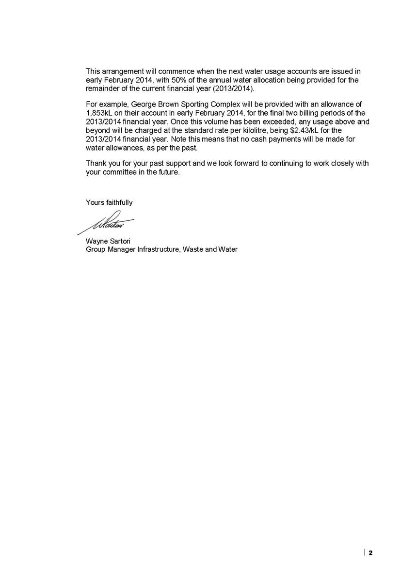
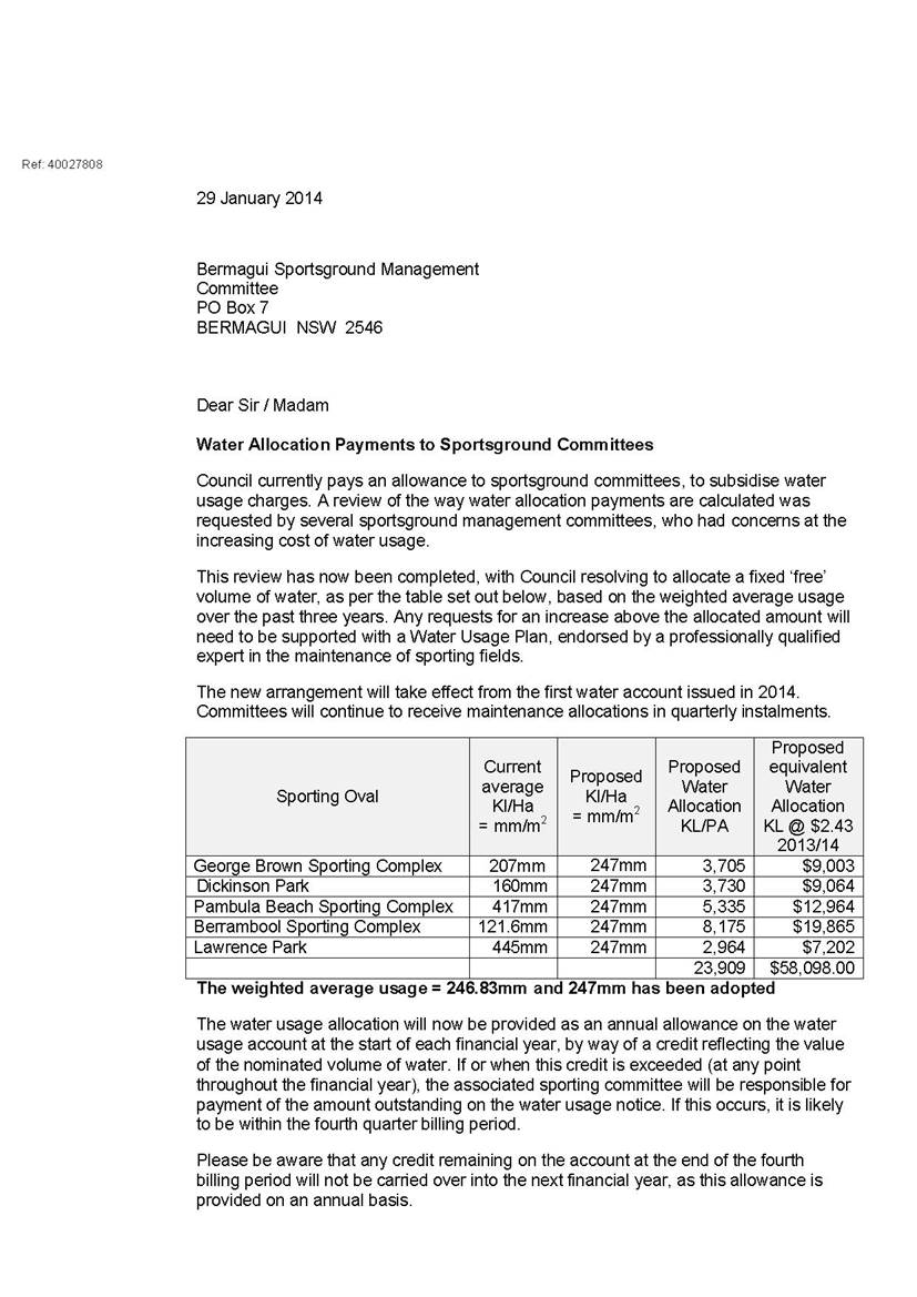

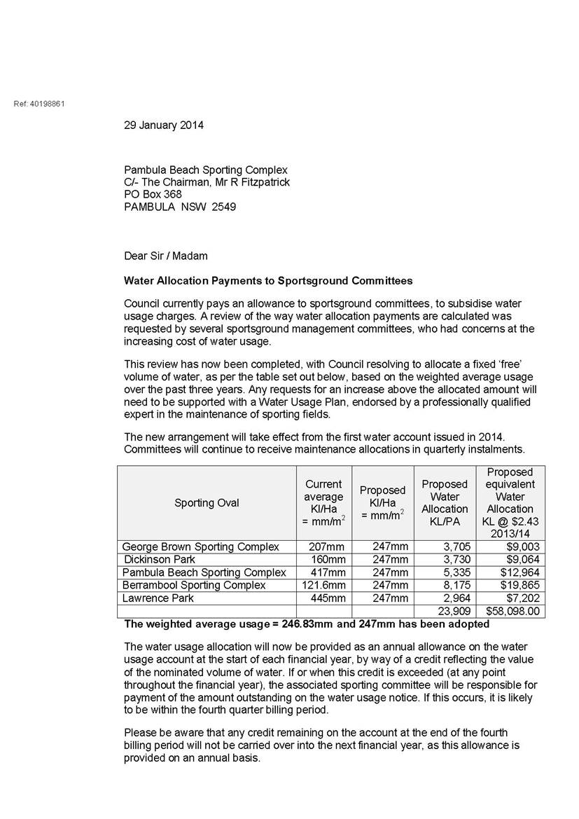

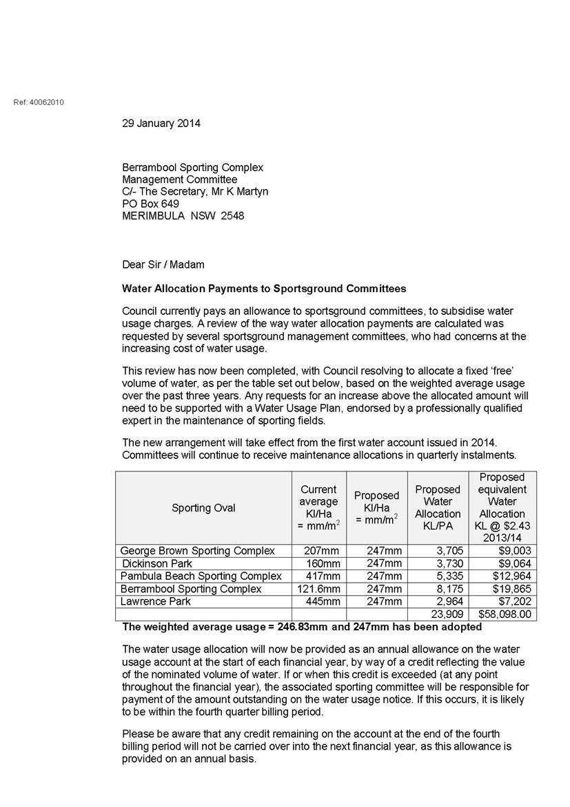

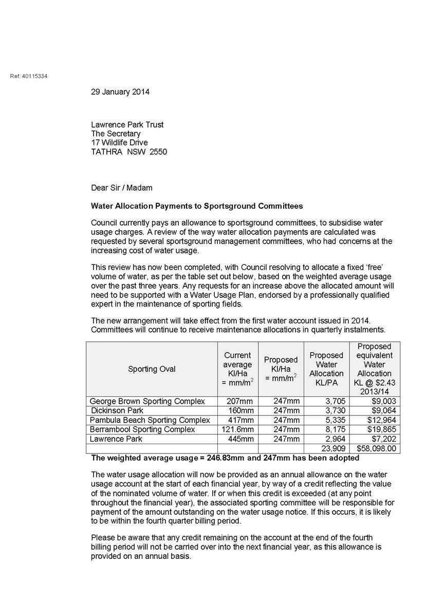

|
Item 12.3 |
12.3. Merimbula Airport Leases
Council approval is sought to offer the existing landside lessees at Merimbula Airport with further tenure of six years.
Director Community, Environment and Planning
|
1. That Council receive and note the report. 2. That Council authorise the General Manager or their delegate to re-negotiate agreement of the lease footprint relating to lease LS-06 at the Merimbula Airport with the rental fee to be calculated on the agreed footprint area. 3. That Council authorise the General Manager and Mayor to execute the necessary lease documentation to provide a further tenure of six years to each of the existing lessees at Merimbula Airport as detailed in the report to Council of 31 October 2018. 4. That Council’s formal written consent is required to any and all future sub leasing arrangements at the Airport to ensure that such sub tenancies do not conflict with or impede operation of the site as a regional Airport. |
Executive Summary
Council recently resolved to provide the ten landside lessees at Merimbula Airport with further tenure of three years. The lessees requested Council’s consideration in offering longer term security of tenure and following further consultation between officers working on the Airport Master Plan and legal representatives, Council approval is now sought to offer the lessees with six years tenure.
Background
The ten landside leases at Merimbula Airport expired in 2017 and have been on a monthly holding over basis since that time. Council resolved at its Ordinary Meeting of 14 March 2018 to provide the existing lessees at Merimbula Airport with further tenure of three years.
Following the Resolution of Council, officers have been liaising with the lessees to action the Resolution of Council. The lessees expressed concerns regarding the length of tenure being offered and requested Council officers look into solutions to provide longer term security of tenure for up to twelve years. Following consultation with the lessees, Council officers sought legal advice to see if there was any possible way of granting the longer term security of tenure as requested.
In addition, Council had also previously resolved to offer a contract extension to the incumbent Airport operator who is one of the landside lessees. The outcome of that offer and subsequent consequences and recommended actions are the subject of a further report to the 31 October 2018. Pertinent to this report is the fact the current Airport operator has declined to extend the contract. Irrespective of a determination on ongoing future airport operational arrangements, there are access and infrastructure requirements associated with lease LS-06 that are considered necessary to continue to effectively operate the Airport. It is proposed that to minimise the need for infrastructure construction or modification, alternative lease arrangement be determined. The alternative lease arrangements would allow the current lessee to continue to utilise space and undertake functions as required whilst also allowing the ongoing operation of the Airport.
Following receipt of the advice referred to above from Council’s legal representatives, Council officers consider it appropriate to offer the following existing lessees with six years security of tenure in the form of two, three year consecutive lease agreements.
|
Lease Site |
Lessee |
Site Size (m2) |
Commencing
Rental Fee |
|
LS-01 |
Bakersair |
406.9m2 |
$5,253.08 (plus GST) |
|
LS-02 |
Sapphire Coast Autos T/A Hertz |
530.3m2 |
$6,846.17 (plus GST) |
|
LS-03 |
Merimbula Air Services |
120.9m2 |
$1,560.82 (plus GST) |
|
LS-04 |
Executive Charter Flights |
986m2 (915.17m2 commercial & 70.83m2 aircraft storage) |
$11,814.84
(commercial) $522.73
(aircraft storage) |
|
LS-07 |
John Moffatt |
429.7m2 |
$3,171.19 (plus GST) |
|
LS-08 |
Done, Bourke, Phillips & Others |
523.2m2 |
$3,861.22 (plus GST) |
|
LS-09 |
Bakersair |
1,464m2 |
$18,900.24 (plus GST) |
|
LS-11 |
Merimbula Aircraft Maintenance |
1,099m2 |
$14,188.09 (plus GST) |
In addition to the above, Council officers also consider it appropriate to re-negotiate a mutually suitable lease area for lease LS-06 with Aviation ID with the lease rate to be reflective of the agreed floor area and using the same methodology as other lease values have been calculated.
Council officers do not consider it appropriate to provide the twelve years tenure as requested, due to the Master Plan review and potential to remove/relocate some of the landside assets subject of existing leases.
Given the location of the underground fuel storage operated by BP Australia is not likely to change with the terminal upgrades and Airport Master Planning that is under way, it is considered appropriate to offer ten years tenure in the form of two, five year consecutive leases as follows:
|
Lease Site |
Lessee |
Site Size (m2) |
Commencing
Rental Fee |
|
LS-13 |
BP Australia |
794.4m2 |
$10,255.70 (plus GST) |
Options
The options available to Council are:
1. Continue with the current Council Resolution of 14 March 2018 and provide the existing lessees at Merimbula Airport with three years tenure; or
2. Resolve to provide further tenure of six years to each of the existing lessees at Merimbula Airport as recommended by Council officers and detailed in this report (officer recommendation); or
3. Resolve to provide further tenure of twelve years or more to each of the existing lessees at Merimbula Airport, however Council officers consider it a risk to provide longer tenure as requested due to the Master Plan review and need to stipulate the rental figure in each lease term. Although there is a mechanism for Council to offer longer term tenure without the need for subdivision of the land, there is a need to specify commencing rent in each lease term at the time the lease is granted. Furthermore, legal advice received was that there may be a reasonable assumption the rent in any new lease be similar or calculated in a similar way, essentially limiting Council’s capacity to respond to a new Airport environment.
Community Engagement
Consultation undertaken
Council officers have consulted with the current airport lessees since the Council Resolution made on 14 March 2018 which included facilitating a meeting with the lessees at Council’s Bega Office as well as numerous letters and telephone conversations to keep them well-informed of progress during the negotiation period.
Council’s legal representatives have also been consulted throughout the negotiation period to provide advice and solutions to grant the lessees with longer term security of tenure they requested.
A site meeting was held between Airport lessees at their request with Councillors and officers on the current concerns of lessees and discussing opportunities to provide greater future certainty for them.
Council consideration of input
Council has received a number of reports and briefings in regard to Airport leases, Airport management and the Airport redevelopment, which are distinct, but all interrelated.
Financial and resource considerations
As detailed in the attached report to Council dated 14 March 2018, a market rental valuation for the Airport lease sites was obtained in 2014. As recommended in that report a further market rental valuation should be obtained at the conclusion of the first three year lease term.
Lease fees for the first three year term are set out above and will be increased annually by CPI (All Groups –Sydney).
Council officer time has been required to consult with the lessees and external legal representatives regarding the requirement for new leases. Further liaison with external legal representatives will also be required to arrange the new lease documentation. Ongoing management of the lease agreements during the term will also require Council officer resources as required.
Legal /Policy
External legal representatives have been consulted since the matter was last reported to Council on 14 March 2018 to enable Council officers to consider offering lessees with longer term tenure without the need to subdivide the land for lease purposes. The advice received was that so long as Council continue to include a clause relating to the Airport Master Plan in any new lease agreement granted, which requires Council to offer a new lease on terms similar to the existing lease for the remainder of the term, the Registrar-General’s Guidelines provide that successive five year term leases are acceptable, without the need for subdivision. It was however noted there may be a reasonable assumption the rent in any new lease be similar or calculated in a similar way which is another reason Council officers are recommending six years tenure not twelve as requested.
Section 53 of the Real Property Act 1900 (NSW) (RP Act) provides that land leased for more than three years must be in the approved form and section 42(1)(d) of the RP Act and the Registrar-General’s Guidelines requires a lease for a term exceeding three years to be registered on title. The Registrar-General’s Guidelines notes the commencement and termination of a lease can be a specified date or the happening of a certain event. It was therefore suggested that the term of each lease could be determined by reference to a specified date and/or adoption of the Airport Master Plan.
Impacts on Strategic/Operational/Asset Management Plan/Risk
Risk
There are no adverse risks in allowing the lease sites to continue to be occupied by the lessees provided the use is authorised by way of a formal lease agreement which contains appropriate indemnity and insurance clauses.
Attachments
1⇩. Merimbula Airport Leases Council Report - 14 March 2018
2⇨. Confidential Attachment to Council Report on Merimbula Airport Leases - 14 March 2018 (Councillor Only)
|
Council |
31 October 2018 |
|
Item 12.3 - Attachment 1 |
Merimbula Airport Leases Council Report - 14 March 2018 |
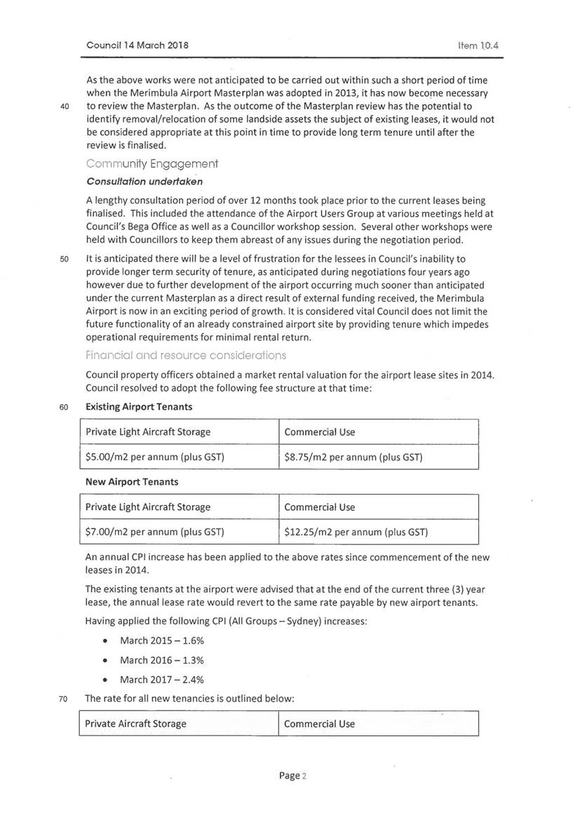
|
Item 12.4 |
12.4. Mirador Emergency (Secondary) Access
Council has recently received a petition requesting the reopening of the Berrambool Drive connection to the Mirador Estate, for the purpose of a secondary access to be used as an emergency access.
Director Assets and Operations
|
1. That Council consider the existing emergency access connection from Camilla Court to Berrambool Drive is adequate for an emergency access and undertake necessary maintenance to provide all weather two-wheel drive emergency access. 2. That officers investigate the alternate route connecting to Casuarina Place, Tura Beach through future stages of the Mirador Estate. |
Executive Summary
Council has recently received a petition requesting the reopening of the Berrambool Drive connection to the Mirador Estate. The petition, with 137 signatures, states “In light of the recent Tathra fires, we the residents of Mirador estate and concerned neighbouring areas require the currently blocked off access to Berrambool Drive reopened permanently to allow a fire escape route as required by NSW State Planning Authority”.
An emergency route exists connecting Camilla Court to Berrambool Drive through Council owned Community land. This existing emergency route was a result of previous concerns raised in 2012 through a Question on Notice. The response provided by the then Group Manager of Transport and Utilities Group proposed to construct an earth ramp linking the existing pavements of Camilla Court and what was the extension of Berrambool Drive. Construction was undertaken and exists currently, subject to some minor maintenance issues. The emergency access is currently restricted by a locked boom gate under Council control.
Background
The Mirador Estate is an approved 275 lot urban subdivision originally assessed and approved back in the late 1980’s and early 1990’s. The estate has had several Modifications of Consent along with multiple developers/owners since its original approval. The take up of land in the early stages of the estate took several years, however there has been consistent growth with building development in the last 10 years. As a consequence, enquiries are being received regarding access through Berrambool Drive as the occupation rate increases.
The original Development Consent sets Condition No. 37 regarding the temporary access via Berrambool Drive to Camilla Court for the first 64 lots. The Development Consent goes on to state “the access to Berrambool Drive shall be established as a Temporary Road pursuant to Section 327A of the Local Government Act, 1919 as amended”. Once Road A (Mirador Drive) has been constructed to link to Sapphire Coast Drive, the temporary road shall be closed and established as public reserve, the constructed road pavement shall be removed and cul-de-sac bulbs shall be constructed at the ends of Berrambool Drive and Road H (Camilla Court).”
As a consequence of the Question on Notice in 2012, one lane of Berrambool Drive was removed and the access ramp and locked boom gate linking Camilla Court were constructed, thus complying with the original Consent Conditions. This access now provides an emergency access link to Berrambool if ever required and would meet the needs of the relevant emergency combat agencies.
Options
The options being considered are:
1. Retain existing configurations.
2. Undertake maintenance to the existing emergency access with an upgrade to a two-wheel drive standard. However consideration would need to be given regarding the status of the gravel section and what improvements would be permissible being Community land along with funding constraints.
3. Reopen the connection from Camilla Court to Berrambool Drive via a reclassification of land/compulsory acquisition and a public road opening. Council may reclassify Public land from Community land to Operational land by way of a Planning Proposal. Where this is the case, a public hearing must be held and a report provided to Council that contains details of the submissions made to the public hearing and recommendations. The public hearing must be carried out in accordance with relevant provisions of the Environmental Planning and Assessment Act 1979 and the Local Government Act 1993. Council is also required to give notice of the intention to hold a public meeting and engage an independent person to conduct the hearing. Based on the Planning Proposal times from commencement to completion this could be a 6-8 month process. This will also involve engaging a land surveyor to undertake the necessary surveys and prepare the survey plans for lodgement with the Land Registry Service. Along with plan preparation there would be associated legal costs re-establishing legal connection to the proposed road reserve alignment. The cost would be expected to be borne by Council (estimated up to $20,000). The legal costs and time frame would be significant and would be considered to be a lengthy option. The total cost of such a project would need to be further investigated and reported to Council as significant civil construction works would be required to provide a two-lane pavement.
4. Investigate options for an additional emergency access linking to Casuarina Place, Tura Beach through future stages of the Mirador Estate with the current owners of the balance of the estate. This would not only provide an additional emergency access for the Mirador Estate but would provide an emergency access for the southern section of Tura Beach.
Community Engagement
Consultation undertaken
To this date the only consultation undertaken has been with regards to the previous decision made by Council in 2012 and the community inter activeness generated by the recent petition.
Consultation Planned
Once a formal decision and direction has been adopted by Council, further consultation would be able to be undertaken where, deemed necessary.
Council consideration of input
This report is envisaged to provide Council with the opportunity to consider the matter and provide a preferred course of action. It is anticipated the adopted course of action will be further investigated and reported back to Council for final consideration and approval, along with more committed financial figures.
Financial and resource considerations
Dependant on Council’s preferred course of action, the financial burden to Council would need to be further investigated and reported back for final consideration.
Legal /Policy
Council is not required to determine the course of action for the treatment of the existing emergency access, in line with the provision for Planning for Bushfire 2006 regarding a secondary access, as the approval date of the Development Consent precedes the Planning for Bushfire 2006. There are no legal obligations for Council to retrofit the estate to meet the current legislation.
Policy 5.01 Asset Management set a broad framework for implementing consistent asset management processes throughout the Bega Valley Shire Council and to ensure adequate provision is made for the long term management of infrastructure assets by:
· Ensuring that Council’s services and infrastructure are provided in a sustainable manner, with the appropriate levels of service to users and the environment.
Impacts on Strategic/Operational/Asset Management Plan/Risk
Strategic Alignment
Councils Asset Management Plan, Transport – June 2017 states that it will operate and maintain assets to provide the defined level of service to approved budgets in the most cost-efficient manner. The operation and maintenance activities include regularly reviewing appropriate emergency response capability. The current configuration has been reviewed and the emergency access is to a sufficient standard to enable a controlled evacuation.
Economic
Lifecycle costs for any proposed continued annual maintenance of the existing formation needs to be taken into consideration when deciding on the best option. Council have expended budget previously in constructing the access ramp to its current standard. An annual maintenance program would need to be considered for budget purposes.
Options 2-4 would change the asset base of Council and need to be further reviewed to determine the full extent. Any upgrades do change Council’s maintenance regime.
Risk
The existing formation of the emergency access is to a sufficient standard to enable a controlled evacuation if required as directed by the lead emergency combat agency. The current risk has not changed since the construction of the current configuration.
Social / Cultural
The impacts to the community would be based on the uncertainty of continued maintenance of the emergency access in particular the unlocking of the boom gate. In times of emergency (fire) the gate would be controlled by the lead emergency combat agency (RFS) directing the flow of evacuation. This outcome needs to be relayed to the residents of the Mirador Estate.
Attachments
1⇩. 1989.1180 Modified consent 6 February 2012 Lot 338 DP 1124839 Mirador Drive MERIMBULA
2⇩. Mirador map showing existing and proposed emergency access
3⇩. Mirador fire access showing tenure of land
|
Council |
31 October 2018 |
|
Item 12.4 - Attachment 1 |
1989.1180 Modified consent 6 February 2012 Lot 338 DP 1124839 Mirador Drive MERIMBULA |
|
31 October 2018 |
|
|
Item 12.4 - Attachment 2 |
Mirador map showing existing and proposed emergency access |
|
Item 12.5 |
12.5. Draft Revised Short Point Coastal Access Masterplan
Summary of consultation feedback and recommended amendments to the Draft Revised Short Point Coastal Access Plan exhibited in March 2018.
Director Assets and Operations
|
That Council adopt the revised Short Point Coastal Accessibility Plan exhibited in March 2018 with recommended amendments included in the Short Point Revised Coastal Access Plan Consultation Feedback Summary Table included in this report. |
Executive Summary
At the Council meeting on 16 August 2017 Council considered the report Short Point – Coastal Accessibility Review. A number of the Resolution items required material amendments and removal of some elements that had been included in the Master Plan adopted by Council in December 2016. Noting the scale of the changes, particularly removal of paths and furniture, and a revised version of the Plan was developed reflecting the Resolution and placed on public exhibition in March 2018. The main changes from the Plan adopted in December 2016 and the revision attached are:
· Grouping Elements – Promenade footpath and viewing areas, picnic area, amenities, furniture and seating.
· Viewing Areas and Decks – Provides viewing decking off the promenade path. Retains but reduces the size of the existing viewing platform.
· Paths - Removes accessible path links to the existing beach access steps and viewing platform.
· Park Furniture – Removes furniture and seating from the grass embankment area. Provides park furniture and seating on the promenade decking areas.
The report provides a summary of feedback and recommends amendments based on that feedback.
Community Engagement
In the development of the adopted Master Plan in 2016 there was considerable community engagement and consultation. That consultation included posters and notices on site, radio promotion, media releases, on-line surveys, key stakeholder group meetings and site drop in sessions open to all. The information and feedback gathered during this consultation informed the inclusions and outcomes in the Plan adopted in December 2016. A summary of that consultation and feedback is included in the Master Plan document.
Consultation undertaken
On 15 March 2018 notification of the exhibition was emailed with links to 22 representatives of various community groups and organisations that had shown an interest in the project. That email included a request for people to forward it on to their members and others that may be interested.
A general media release was also distributed on 15 March 2018.
There were 30 comments made on the Bega Valley Shire Council (BVSC) ‘Your Say’ page and a further eleven emails received. Copy of the ‘Your Say’ comments are attached. Emails are also included as Councillor Only attachments.
Consultation Summary
Not surprisingly there were some differing views expressed in the feedback received during the exhibition period. This reflects the different users of the area and also the differing objectives of the project. There is no question each of the project objectives is important and has merit however when it comes to implementation sometimes individual objectives can conflict. For example, too greater expansion of coastal vegetation will affect recreational opportunities and potentially views. Removal of recreational features to improve visual amenity can reduce recreational opportunities and will also affect accessibility. Installation and development of structures on the site can affect visual amenity and can also affect cultural sites. The Coastal Accessibility Plans look to achieve a balance between these objectives. The wording of the objectives reflects this by looking toward ‘improvements’ and ‘enhancements’ to deliver an overall improved outcome.
Within the feedback there are themes which can be clustered and generally these relate to key items and elements numbered in the Plan. A summary of the feedback by these themes and Plan elements and recommended amendments is provided in the table below.
Short Point Revised Coastal Access Plan Consultation Feedback Summary.
|
Plan Item |
Comments General Summary |
Recommendation |
|
General Theme of Comments |
Natural areas and views are the best asset. Can do with some improvements but don't overdo it. Don't over develop. |
Noted. Reduce scale where possible noting access and expected circulation areas and needs. |
|
Accessible Path Link |
Keep it simple. Concern on view impacts of balustrade if needed. |
Reduce the need for balustrade where possible. Utilise steps or other elements or appropriate edge barriers where possible. |
|
Upgrade Car Park |
Maximise car parking. |
Maximise parking. Accessible parking both ends of the lower carpark aligned to steps / links from upper parking. |
|
Promenade and Accessible viewing areas. |
Good for accessibility. Don't over develop. Concern on view impact of balustrade if needed. Think about area at eastern end. |
Provide promenade / viewing area at each end. Delete middle area to reduce scale and development and have a modest sized viewing area at the eastern end of the promenade. (note feedback on existing 'sun lounge' seating below) |
|
Beach Viewing / Seating |
Keep existing sun lounge features. Provide seating along promenade and headland walk paths. |
Provide seating along paths, provide some feature 'sunlounge' type seating. Utilise steps as terrace seating where suitable. Seats to be installed along and at the end of the headland path |
|
Picnic Area |
Provide enough picnic area, seating and tables. |
Include second picnic area where there will be minimal impact on views. (lower level near and north of amenities building; steps to access) |
|
Existing Viewing Area |
Works and is OK as it is. Retain it. |
Upgrade at reduced size including SLS rescue board & flags storage area under; as per recent consultation feedback. |
|
Multi-Purpose Building |
Don't overbuild. Is a 'multi-purpose' building needed? Kiosk will be under used. |
Contemporise design to reduce visual effect on surrounds. Include public amenities & storage. Design to consider planned area for small kiosk for possible development if there is future demand. (Area to be set up to be used as a seasonal mobile food van space until kiosk is developed) |
|
Coach Access |
Is it needed? Keep it minimal |
Strong links and value to the community through accessible tourism. Review for minimum workable requirements. |
|
Other - Levels and excavation |
Reduce excavation levels |
Utilise existing site levels where possible. Will relate and need to be balanced against need for balustrade and impact on views. |
|
Other - Suggested projects / works |
Path along Short Point road, renew / upgrade Merimbula boardwalk, improvements spencer park. |
Note project links and consider for future works and funding opportunities and priorities. |
Short Point Revised Coastal Access Plan Consultation Feedback Summary Table.
Financial and resource considerations
The Plan has been predominantly funded through successful grant application through the Regional Growth: Environment and Tourism Fund. The BVSC contribution shows commitment to the project and relates to scheduled asset renewals. There have also been grant funds sourced through the Department of Primary Industries (DPI) Fisheries Observation Towers Program and the NSW Office of Environment and Heritage.
|
Funding Source - Short Point Destination For All Project |
Value |
Pro rata % |
|
NSW Government - Restart NSW (Regional Growth Environment and Tourism Fund) |
$1,018,887 |
84 |
|
Bega Valley Shire Council (Asset Renewals) |
$88,000 |
7 |
|
NSW Office of Environment & Heritage |
$70,000 |
6 |
|
NSW Dept of Primary Industry (Fisheries – Observation Platforms) |
$30,000 |
2 |
|
Community Groups (Fund-raising / In-kind / Project contribution) |
$10,000 |
1 |
|
Total |
$1,216,887 |
100 |
Impacts on Strategic/Operational/Asset Management Plan/Risk
Strategic Alignment
A key aspect of developing Strategic Plans is a clear understanding of the objectives, benefits and long term outcomes the Plan is to deliver. The objectives for the Coastal Accessibility Master Plan at Short Point were:
· Improved, safe access to beach, estuary and headland
· Protect and expand the coastal vegetation communities
· Reduction in area impacted by environmental weeds
· Stabilisation and revegetation of all areas subject to erosion
· Improve visual amenity of Short Point
· Enhanced recreational environments and opportunities
· Improved community engagement and education and opportunities focusing on coastal ecosystems, coastal processes, cultural heritage, entrance management and weed management
· Recognition of sites of Aboriginal and European heritage
· Enhanced visitor and tourist experience.
Asset Management and Operations
Asset Renewals - The location of scheduled asset renewals will be directed by the coastal accessibility Master Plans. This looks to achieve best use and value from assets considering changing needs and use. Individual elements and projects are being directed by the Plans and as these come together over time the full value of a coordinated approach to parkland and recreation planning will be realised.
Operational - Elements within the Plan look to balance and meet practical and operational needs with the objectives. (i.e. car and coach parking, distributing use, limiting congestion, accessibility). As a particular example, upgrading the existing viewing platform at Short Point will improve the operational delivery of the summer beach lifeguard program by providing elevated viewing of patrol area and beach (including the rock platform area at the southern end of the beach). It will also provide opportunity for onsite storage of long and bulky items needed by lifeguards (i.e. rescue boards, flags, signs etc.)
Environmental / Sustainability
Protection and restoration of the coastal environment is one of the key objectives the coastal accessibility Master Plans, looking to manage and balance along with accessibility, heritage and recreation use.
Economic
Implementing the coastal accessibility Plans links strongly with improving facilities related directly to tourism and in particular the increasing market area of accessible tourism.
Risk
Funding - The funding achieved through the Regional Growth Environment and Tourism fund was based on the schedule of estimated costs included in the Master Plan adopted by Council in December 2016. While there are some changes on balance the additional items and excluded items should result in similar costing to the 2016 adopted Plan. None the less the project funding is what it is and it is recommended the project progress based on that resourcing with additional grant opportunities be investigated if there is a shortfall.
Program - With the funding, there is a need to progress with the project which needs an adopted Plan. Halting or delaying works can create uncertainty in project delivery and future grant applications. This may be managed by redirecting grant funding to other projects elsewhere in the Shire that meet the funding program objectives, if acceptable to the funding agency.
Expectations - Developing and raising expectations - Council will be able to deliver all desired outcomes to all different groups. Balanced improvements and enhancement across all objectives is the aim of the planning process.
Social / Cultural
The coastal environment is one of the key assets enjoyed by residents and drawing people to the Bega Valley Shire and Sapphire Coast. The Coastal Accessibility Planning project links these fundamental social and environmental elements and puts improving accessibly and inclusiveness as a key recreation planning objective at the popular coastal sites.
Options
1. Council adopt the revised Short Point Coastal Accessibility Plan exhibited in March 2018 with recommended amendments included in the Short Point Revised Coastal Access Plan Consultation Feedback Summary Table included in this report reflecting feedback from the community consultation.
2. Council adopt the revised Short Point Coastal Accessibility Plan exhibited in March 2018 with NO changes reflecting feedback from the community consultation.
3. Council re-endorse the Short Point Coastal Accessibility Plan adopted by Council in December 2016 with no changes.
Conclusion
The Short Point Coastal Accessibility Plan looks to balance objectives relating to accessibility, recreation, environment, heritage and amenity. Noting the thorough consultation and engagement plan delivered in developing an adopted Plan, and the comments and feedback received on the draft revised Plan exhibited in March 2018, there is scope for some changes to the adopted Plan. These are recommended in the table included in the report.
Attachments
1⇩. Online Consultation Feedback Short Point - Coastal Accessibility Master plan – Bega Valley Shire Council
2⇨. E-mail submissions - Revised Short Point Coastal Access Plan exhibition March 2018 (Councillor Only)
3⇩. Short Point Coastal Accessibility Masterplan
|
Council |
31 October 2018 |
|
Item 12.5 - Attachment 1 |
Online Consultation Feedback Short Point - Coastal Accessibility Master plan – Bega Valley Shire Council |
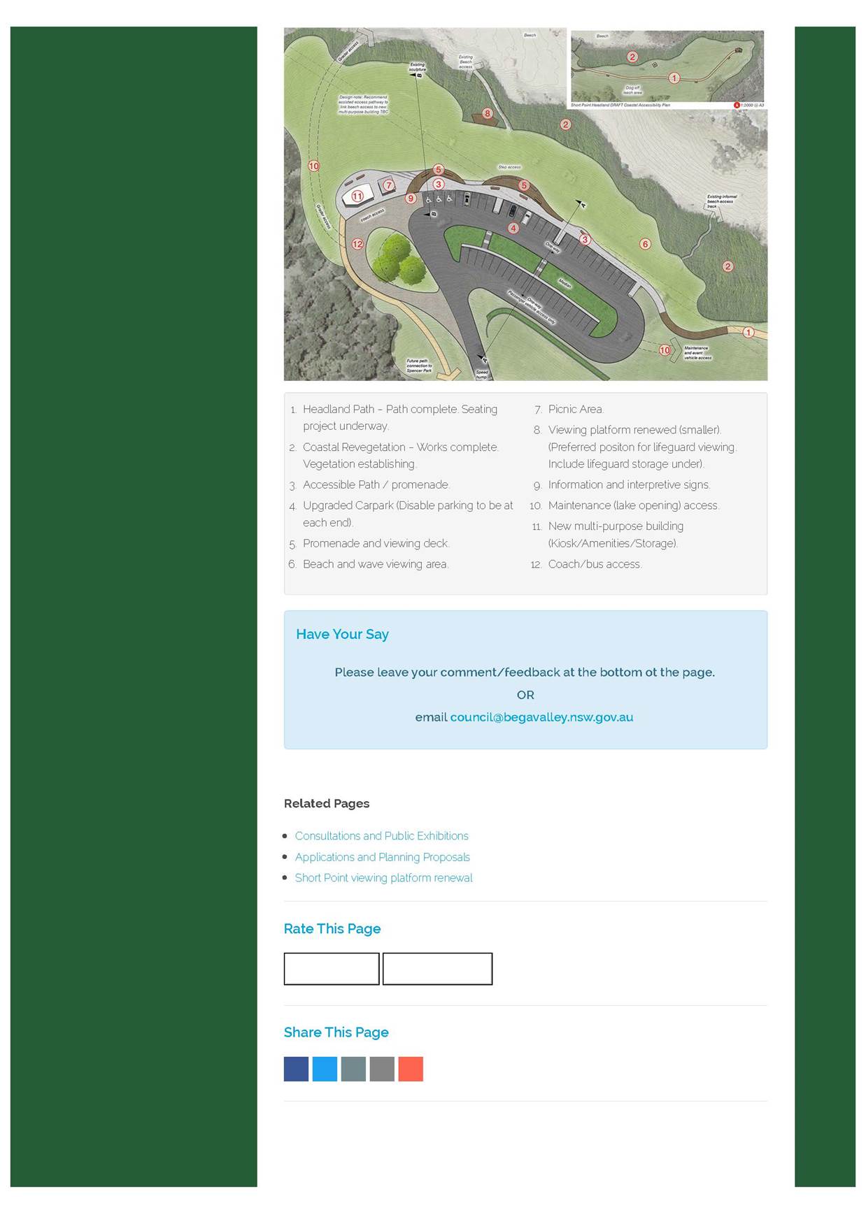
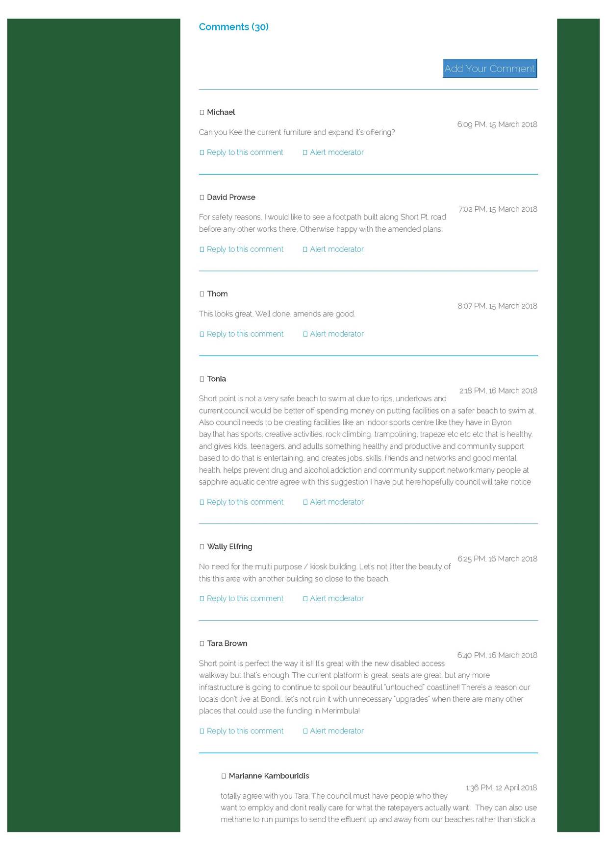
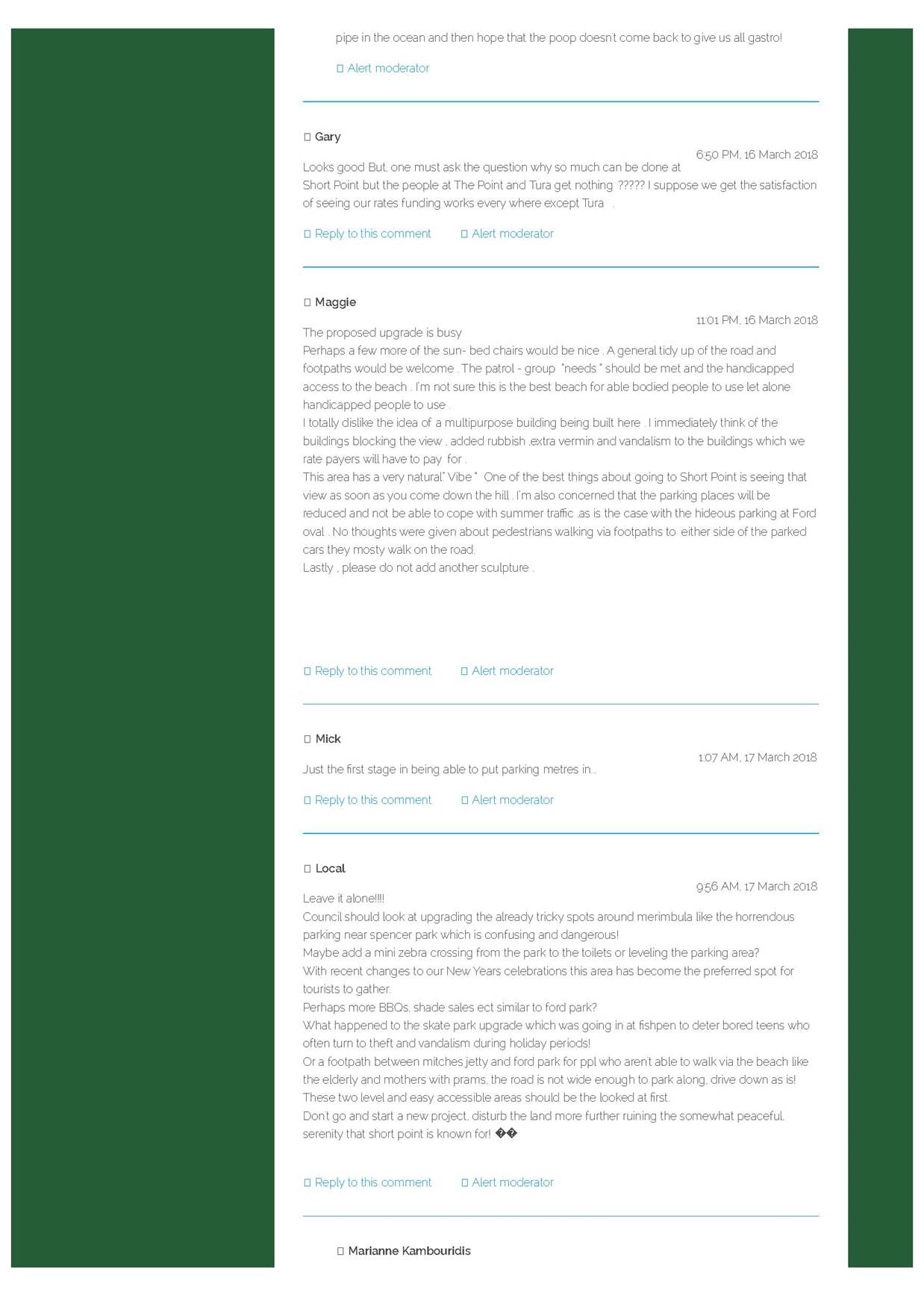
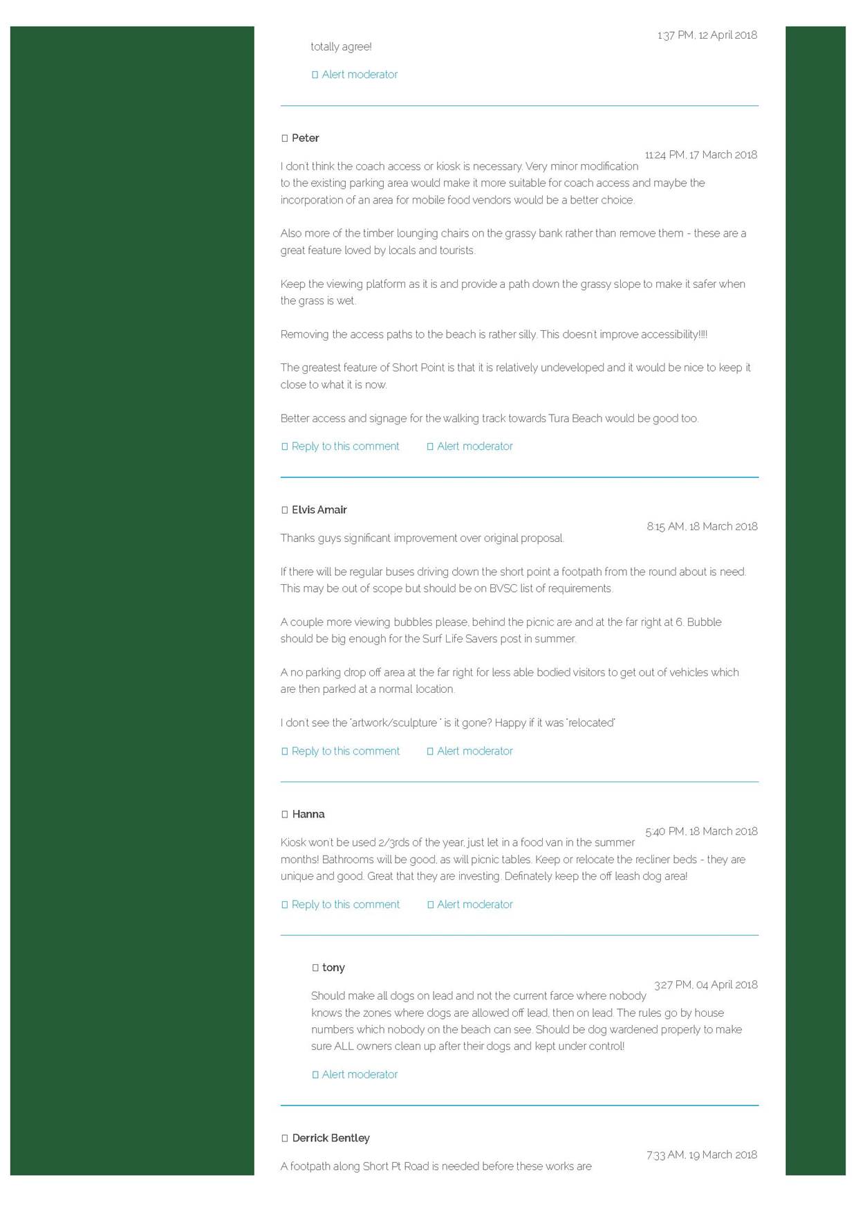
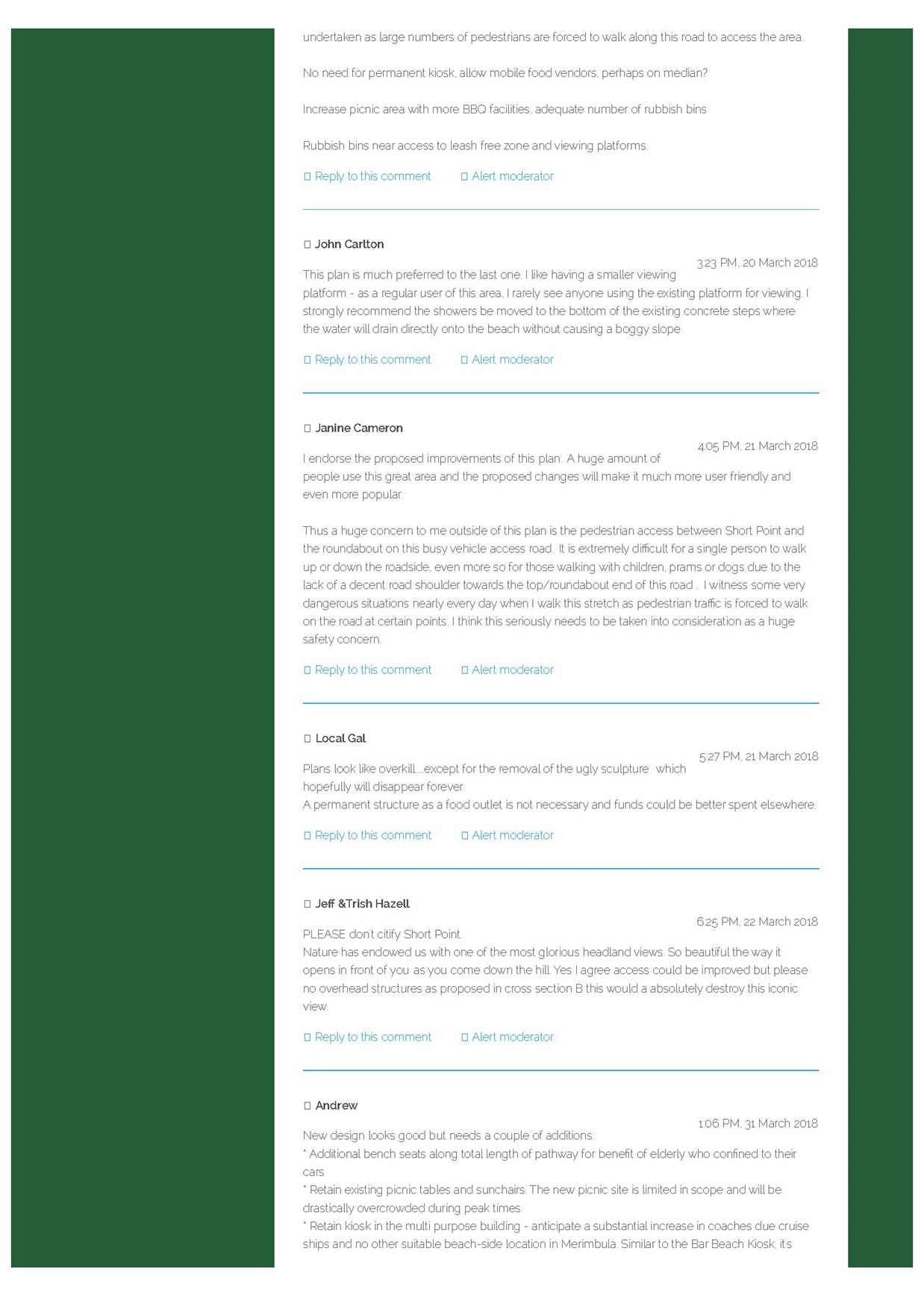

|
Item 12.6 |
12.6. Management and Operation of Merimbula Airport
This report has been prepared to update Council on the transitional arrangement for the management and operation of Merimbula Airport and to recommend a course of action in relation to the management of the Airport.
Director Assets and Operations
|
1. That Council adopts the recommendations included in the Confidential Attachment to this report. 2. That Council make the Confidential Attachment to this report public. |
Executive Summary
At the Council meeting of 13 December 2017 Council resolved to enter into negotiations to extend the existing Contract for Services for the management of Merimbula Airport for an additional two (2) years in accordance with existing contract documentation RFT 48/16 with Airport Agencies.
Background
Council officers commenced negotiations with Airport Agencies to extend the existing Contract for Services and on 3 May 2018 the Director of Airport Agencies formally advised of their intention to resign as the Airport operator by 31 December 2018.
Since receiving the above advice, Council officers have been assessing options available to continue operations at the Airport within the context of major upgrades projects currently progressing.
There are several options available, each with their own set of risks. The main options available in broad terms are:
1. Council take over full operations and management of the Airport
2. Council go to tender for operations and management for all or part aspects of the Airport
3. Council enter into direct contract negotiations for operation and management of the Airport for an interim period until major projects underway are complete at which point Council either goes to public tender or takes over operation and management of the Airport.
The merits of each of the above options and a recommended course of action are included in the Confidential Memo attached to this report.
The current Civil Aviation Safety Authority (CASA) Regulations prevent an Aerodrome Certificate from being transferred. To facilitate a change of Aerodrome operator, the existing operator must request the cancellation of their existing Certificate in conjunction with the approval of the application for a new Certificate from the incoming operator.
The entry control assessment of the incoming operator can be performed whilst the current operator maintains operations in accordance with their existing Certificate. Ideally, the cancellation of the existing Certificate and the issue of the new Certificate to the incoming operator will occur concurrently and can be coordinated between both parties.
Council officers have commenced discussions with both CASA and Airport Agencies to facilitate the change of the Certificate holder from Airport Agencies to Bega Valley Shire Council.
A key element of the transitions of the operations is the need to have in place all regulatory documentation and ensure that Approved Person(s) are appointed with the necessary experience of Aerodrome planning, maintenance and operation.
A recommended course of action for complying with the above requirements is included in the Confidential Memo attachment to this report.
Financial and resource considerations
The current budget provides a contract management allocation for the Merimbula Airport, based on forecast revenues from property leases, aircraft landing fees and RPT passenger levy.
The extent to which Council resources are required are dictated through management of the Service Contract, ongoing administration, management and financial oversight.
Legal /Policy
CASA is the key Statutory Authority that conducts the safety regulation of civil air operations in Australia, including the regulation of certified and registered Aerodromes.
The Aviation Transport Security Act 2004 and associated Aviation Transport Security Regulations 2005, establishes a regulatory regime to safeguard against unlawful interference with aviation.
Council Resolution on 4 February 2015 regarding the operation of the airport, created the current Policy position on the ownership and/or operation of the Airport.
The current Aerodrome Certification is with Airport Agencies and the CASA Regulation 11.080 prevents an Aerodrome Certificate from being transferred. To facilitate a change of Aerodrome operator, the existing operator must request the cancellation of their existing Certificate in conjunction with the approval of the application for a new Certificate from the incoming operator.
Impacts on Strategic/Operational/Asset Management Plan/Risk
Strategic Alignment
The Merimbula Airport Master Plan is the major strategic driver for the Airport and is in the process of being updated to take into account the terminal and runway expansion projects.
The Airport is a critical element of Council’s transport strategic direction and its management into the future will be critical to ensure the best outcomes for the community.
Within Council’s Community Strategic Plan (CSP) the importance of the Airport directly relates to the priorities listed through support of the local economy and the tourism industry and as part of an integrated transport network and support of emergency services.
Indirectly the operations of the Airport provide access to specialist medical and educational services.
It is seen that the continuity of the Operation and Management of the Airport during the infrastructure upgrade is critical to the success of the Airport.
Operational / Asset Management Plan
Maintaining and operating the Airport is consistent with Council’s Operational Plan, as part of its integrated transport network.
Council adopted an Asset Management Plan for Merimbula Airport in June 2017 with the Airport infrastructure being a significant and capital intensive asset.
The ongoing maintenance, renewal and upgrade of the Airport are vital for a safe, secure and reliable aviation operation.
To this end, there is a need for substantial commitment of resources, particularly capital funding, over a long period of time.
Environmental / Sustainability
Merimbula Airport is located in an environmentally sensitive area, between Merimbula Lake to the west and bushland areas to the east of Arthur Kaine Drive, where extensive foreshore dunes form part of Merimbula Beach.
There are also wetland areas to the south, south west and east of the runway and within the Airport site itself.
These areas are environmentally significant wetlands and are identified in SEPP14 and are a key constraint on the master planning of the site which is impacting on the runway and terminal design at the current time.
Economic
The economy of the Bega Valley has been traditionally dominated by primary industry including agriculture, forestry and fishing. While these industries are still significant, a number of other key sectors has developed, in particular tourism and remote area employment.
There is growing momentum for projects linking air freight from the area. The Airport, as part of the regional/national transport network, provides access to business markets and thereby significant support to the local economy and at the same time Airport operations generate a direct economic benefit.
Social / Cultural
Community benefit is arguably the main reason why Council owns and operates an Airport. Airport operations is a vital component of an overall integrated transport network, which links the Bega Valley with capital cities.
The Airport provides essential links for professional, legal, specialist and medical services as well as passengers for tourism, employment and business.
Conclusion
This report and attached Confidential Memo provides information about the background and basis for a recommended course of action for the operational management of Merimbula Airport.
Due to the intention of Airport Agencies to resign from the ongoing operation and management of the Airport, Council needs to take action to ensure the ongoing operation of the Airport.
Council are currently working with both CASA and Airport Agencies to change the Certificate holder of Merimbula Airport which will require that Council appoint Approved Person(s) with the necessary experience of Aerodrome planning, maintenance and operation.
The Confidential Memo attached to this report provides a recommended course of action for meeting licensing and operating
Attachments
1⇨. Confidential Memo - Management & Operation of Merimbula Airport (Councillor Only)
|
Council 31 October 2018 |
Item 12.7 |
12.7. Site Management Plan - Tura Head Coastal Reserve (The Point) and Dolphin Cove Reserve
This report presents to Council legal advice on processes and potential implications of implementation of the Council Resolution of 1 May 2018 relating to Site Management Plan Tura Head Coastal Reserve (the Point) and Dolphin Cove Reserve. The report also provides a further overview of issues and options for the implementation of the Site Management Plan, considering that advice and ongoing enquiries and correspondence from resident groups.
Director Assets and Operations
|
1 That the information in the report and the legal advice attached be received and noted. 2. That Council undertake further community consultation to again assess the local community’s interest in managing the site and improving native vegetation and wildlife habitat or clearing areas to increase mown parkland area. 3 That it is acknowledged the site is one of a broader network of reserves across the Shire and that there are limitations in resources available. |
Executive Summary
The area subject of the Site Management Plan – Tura Head Coastal Reserve (The Point) and Dolphin Cove is one of a network of over 20 natural areas managed by Bega Valley Shire Council (BVSC) across the Shire. A Site Management Plan (SMP) for the area had been developed (available at: https://www.begavalley.nsw.gov.au/page.asp?f=RES-FLZ-00-84-55) following requests from the community and referencing feedback from a community workshop and further online community survey.
With the development of the SMP a volunteer group has been established to assist in implementing the SMP. The volunteer group as it stands, has a mixture of individuals that don’t align themselves to any particular community group whilst there are other members who have clear affiliations with particular community groups.
In particular two local community groups have been established in the northern part of Tura Beach, each having differing views on the management of the reserve. In general terms the Living with Nature Group would like to see management consistent with the current Community Land Classification of Natural Area Bushland. The North Tura Beach Residents Association would like to see an increased clearing of vegetation and much increased mown areas, regularly referencing the land use zoning of RE1 relating to the land.
The SMP that had been in place prior to the Resolution of 1 May 2018 reflects the consultation feedback and provided a balanced approach to making improvements relating to the highest rating values and items from the community consultation. SMP’s are useful in that they define works and provide direction to both the volunteer groups and BVSC officers in supporting those works. The SMP was published March 2018 in preparation for the establishment of the volunteer group.
Upon reviewing Council’s Resolution of 1 May 2018, officers identified concerns that immediately implementing Council’s Resolution may potentially cause a breach of legislation. Legal advice in regards to that concern is attached to this report. From the legal advice it is evident there are a number of steps that would be required prior to being able to consider whether the modified actions (by Resolution) within the SMP could be legally implemented.
This report also provides information to give some context to the management of the site and the use of resources across natural areas across the Shire. Options to move forward with the management of the site are provided to Council.
Background
At the Council meeting on 11 October 2017 Council considered the report 9.3 Tura Beach Coastal Reserves and resolved:
1. Council acknowledges the submissions and opinions expressed by members of two local interest groups and by the broader community and thank them for their input.
2. Council adopts the agreed actions as outlined in Attachment 4 of the report to be undertaken as annual budgets, successful grant funding and staff resources permit.
3. That Council re-establishes emergency access previously provided at Dolphin Cove and The Point.
4. That Council re-establish native grasses that have been colonised by invasive species such as sallow wattle, kikuyu and African love grass.
5. Council calls for expressions of interest from community members to establish a volunteer group to assist in the management and maintenance of the public reserves in the vicinity of The Point and Dolphin Cove Drive, Tura Beach.
The Site Management Plan Tura Head Coastal Reserve (the Point) and Dolphin Cove Reserve was developed and published on Council’s website in March 2018. Expressions of interest were called for community members to establish a volunteer group at the site.
At the Council meeting on 1 May 2018 Council considered the Notice of Motion 18.1 Site Management Plan Tura Head Coastal Reserve (the Point) and Dolphin Cove Reserve. Council resolved:
1. That the following items be further clarified and the information provided to Councillors by memorandum, for inclusion in appropriate works plan for the site:
· Vegetation management items including retention of banksias and melaleucas (trees) at The Point site and Dolphin Cove site (indicated on map) and options for clearing of other vegetation types including wattle (acacia sophorae) and tea tree (leptospermum) and deadwood.
· Management of vegetation canopies on both sites
· Reduction in understory density in secondary Dolphin Cove site when funding becomes available.
· The extent of future vegetation and general site management for The Point site.
· The use intermittent native plantings - not bollards or a walking track - to delineate APZs.
2. That the following Items in the Site Management Plan Attachment A be amended as follows:
· Item 3 – remove installation of bollards
· Item 5 - add the following wording “Remove vegetation in Dolphin Cove Carpark and also clear access path to a width of 3 metres wide to the top of the northern beaches
· Item 6 – amend to read “Remove all Vegetation identified in area 12”.
· Item 12 – Remove the entire item
· Item 13 – amended to read “Update signage”
It is noted the above Resolution differs from the initial Notice of Motion in that part 2 was not included in the original Notice of Motion (i.e. officers had not the opportunity at the time to assess the impacts of the Resolution).
As requested in item 1 of the Resolution a Memo was prepared and distributed to Councillors on 13 June 2018 providing information requested. A copy of that Memo is attached. In drafting that Memo, officers reviewed actions in item 2 of the Resolution and identified that implementation of some of those items may breach legislation or, at the least would require a process of formal site assessment, reporting and approvals which would likely take considerable time and incur costs. This advice was also included in the Memo to Councillors.
Community Engagement
There has been community consultation and engagement related to the management of the site. In reviewing results of community consultation, it is worth considering the statistical figures relating to the community the feedback will represent, and what percentage of feedback is considered reasonable to direct a significant change in the status quo or exhibited documents.
In referencing the local community the figures below can be useful.
· The population of Tura Beach / Mirador area - 3820
· The number of properties within 1km of the SMP site – approximately 620
· The number of people that attended the community drop-in session at Tura Marrang Library on 29 June 2017 – approximately 90.
· The number of people that responded to the online survey after the community drop in session - 192 (144 from the Tura Beach area)
· The number of people that wrote submissions objecting to the published SMP – 11
· The number of people that wrote submissions supporting the SMP – 4
While the number of people providing submissions and feedback to consultation is important it is also important to be mindful of the comparative number that do not. People might not provide feedback for several reasons including:
· They were not aware of the consultation or opportunity to provide feedback.
· They are happy with what has been presented.
· They are ambivalent or not very interested in the issue.
While those that live very close to the reserve may perceive they have a higher level of ownership, the area is managed on behalf of the broader community. It is part of a broader network of parks and reserves that are managed by Council. This is important as the resources available to manage the broader network of parks and reserves needs to be considered to develop a consistent approach to reserves and use of resources. If higher levels of resources are used in one area they will then not be available for use in others and delivering a consistent approach to reserve management will not be able to be achieved.
Consultation undertaken
A community drop-in session was held at Tura Marrang Library on 29 June 2017 as an opportunity for community members to express their opinions on the management and maintenance of Tura Beach Coastal Reserves and to discuss issues and concerns with Council officers as well as the Rural Fire Service. Approximately 90 people attended. This was followed by a workshop session the same evening. Overall there was a fair amount of community goodwill and genuine willingness to work together and with Council.
In the few weeks following the drop-in session, an online survey was undertaken seeking the opinions of community members. 192 people participated in the survey with 144 of them being from the Tura Beach Area.
Tables representing the results of feedback from the drop-in session and the online survey are provided below.
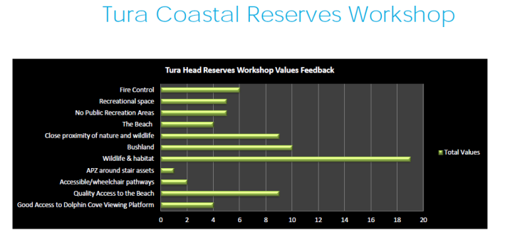
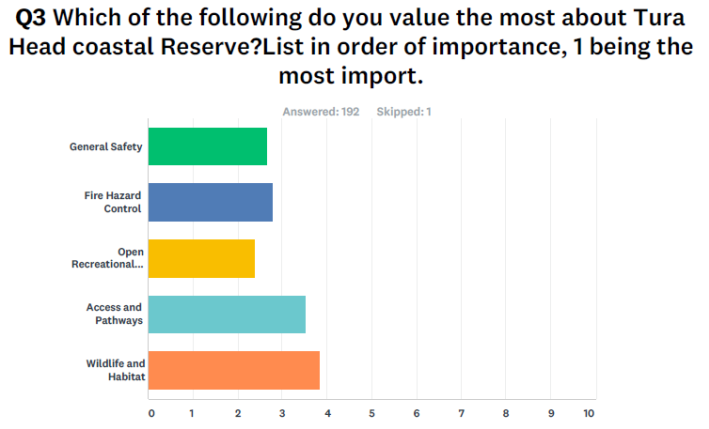
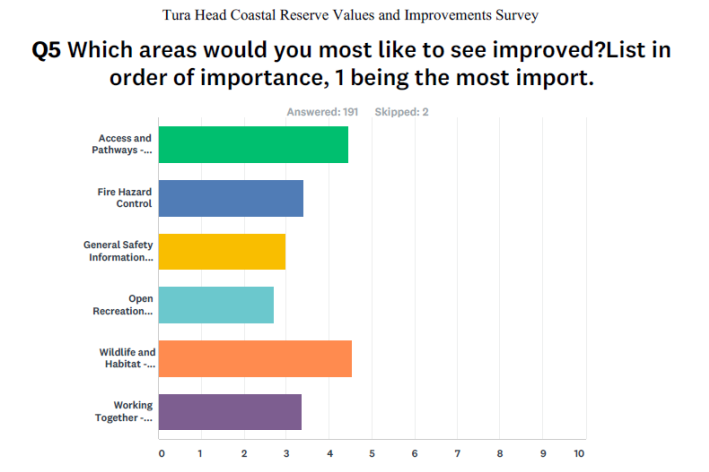
The Site Management Plan – Tura Head Coastal Reserve (The Point) and Dolphin Cove was not subject of a formal consultation process, rather the Plan was based on feedback from community workshops and online surveys. This feedback reflected the priorities of those that participated.
Site Management Plans are typically site specific operational plans. While they are discussed with groups with an interest in the site they are not ordinarily subject to a formal public consultation process. Over time SMPs can change reflecting works completed and changes to the site. However they do not change beyond the scope of the Community Land Classification.
Financial and resource considerations
As stated above, the site is one of a network of natural areas managed by Council. The total budget available for managing vegetation and assets within natural areas is approximately $145k. (excluding fire hazard reduction works) across all sites.
Some members of the established volunteer group have very high expectations on the level of resourcing Council should provide to toward this site and specific actions within the SMP. It is appreciated there are improvements to be made to the management of the area and the SMP reflects this however the area needs to be managed in conjunction with other natural areas across the shire, many of which also require works to manage issues on those sites.
The following is a summary of resourcing that has gone into the SMP site since 1 July 2018
|
Resourcing |
|
Amount |
|
Staff time event preparations |
hr |
25 |
|
Staff time event attendance |
hr |
27 |
|
Staff time administrative (reporting & correspondence) |
hr |
25 |
|
Materials costs |
$ |
4184 |
|
Contractor costs |
$ |
11590 |
There is no question the high level of resourcing to this site will impact on delivery of works in other areas. It will not be possible to continue to resource the site at current levels without reducing works or reallocating funds from other budget areas.
Should Council consider it preferable to continue to pursue implementation of the modified SMP (i.e. with additional clearing) it is likely there would be further considerable financial implications. Firstly, this would involve undertaking a review of environmental factors (REF) as outlined in the legal advice which may then subsequently trigger the need for a species impact statement (SIS), biodiversity development assessment report (BDAR) or environmental impact statement (EIS).Legal /Policy
As a consequence of concerns raised over the ability to implement Council’s Resolution of May 2018 and the obvious differing opinions of different community groups, legal advice was commissioned from Lindsay Taylor Lawyers to provide advice in regard to:
· Confirmation of what legislation applies to management of the site.
· Is the level of information that was used to inform the SMP and referenced in the SMP in regard to the use of land, appropriate vegetation management and/or level of clearing sufficient to stand up if legally challenged?
· Would implementing the Council Resolution above breach the legislation applying to management of the site?
· If implementing the Notice of Motion 18.1 1 May 2018 Resolution is possible without breaching legislation what processes, steps and levels of evidence would be required?
Accompanying the request for legal advice were copies of:
· Site Management Plan - Tura Head Coastal Reserve (The Point) and Dolphin Cove Reserve February 2018
· The Council Notice of Motion and Resolution 18.1 Site Management Plan Tura Head Coastal Reserve (the Point) and Dolphin Cove Reserve.
· Memo to Councillors - Notice Of Motion: Site Management Plan Tura Head Coastal Reserve (the Point) and Dolphin Cove Reserve 13 June 2018.
There is a risk Council will be exposed to a breach of legislation if the site is over cleared and there is a potential that threatened species will be affected. A copy of the complete advice from Lindsay Taylor Lawyers is attached to this report. In regard to implementation of the Resolution the advice states among other things:
17. However vegetation clearing itself (as proposed in the Resolution) is not exempt development, and there may be other activities which cannot fall within the criteria for exempt development in the ISEPP.
20. The SMP does not contain an assessment of the likely effect of the SMP Activities on the environment as required by the EPA Act, EPA Reg and BC Act. Therefore there would be a breach of the EPA Act and BC Act if the SMP Activities (other than the Exempt Activities) were carried out without any additional assessment.
21. Council may determine that those SMP Activities requiring assessment can be carried out once the assessment required under the EPA Act and BC Act is complete. However this would depend on the results of that assessment. It may be that the assessment would need to include preparation and public exhibition of an environmental impact statement (EIS) and species impact statement (SIS) or biodiversity development assessment report (BDAR) under the BC Act, or, if the only likely significant affect was on threatened species, then the preparation of a SIS or BDAR only.
79. As a result of the discussion above, if Council proceeded to implement the SMP as modified by the Resolution, Council would breach Division 5.1 of the EPA Act and the BC Act.
80. However, this does not mean that Council cannot implement the Resolution and SMP.
81. The Exempt Activities can be carried out provided Council has properly considered the criteria for exempt development in clause 20 and 66 of the ISEPP, and is satisfied the Exempt Activities meet that criteria. They could require a permit under the Vegetation SEPP if vegetation removal or pruning is required.
82. If Council wishes to implement the Resolution and SMP in full, it must carry out the assessment in accordance with Division 5.1 of the EPA Act of the remaining SMP Activities, in particular the vegetation removal, including having regard to the factors in clause 228 of the EPA Reg, and complying with the BC Act in respect of the assessment of the impact on the environment, and the habitat and any identified threatened species or communities on the Reserves and Crown Land.
83. That is usually done through an REF (although there is no such document referred to in the legislation).
84. If Council determines that the SMP Activities are not likely to have a significant effect on the environment, including those species and communities, then it can determine to proceed and implement the Resolution and SMP.
Applying a balanced approach to management of the reserve showing consideration of the classification of the land, use of the area and management issues will greatly reduce any potential exposure to breaching legislation. Whilst reference to and understanding of legislation is important it is ultimately a last resort method of risk management and control.
Impacts on Strategic/Operational/Asset Management Plan/Risk
Community Strategic Plan
Management of Natural Areas is related to the following Community Strategic Plan items.
Goal 5: Our air and water is pristine and our natural environment and rural landscapes are protected:
· Strategy 10: Support innovative land use policies, government and community/business partnerships, and community engagement activities that care for and enhance the natural environment.
· Strategy 11: Ensure land use planning and resource use protects the quality of the natural environment, the existing character of rural landscapes and the high value agricultural land.
Asset Management
North Tura Beach reserve is currently classified as ‘local’ within Council’s asset management hierarchy. It is mainly used by locals. Increased parkland development will see increased use and demands on the local area, which will have an impact on local residents.
Throughout the Shire, different localities have different mixes of facility provision. In most cases this has simply evolved over time. The North Tura Beach / Dolphin Cove area is not dissimilar to many costal residential areas across the Shire. Typical assets include beach access paths and trails, viewing platforms and stairs. It has been acknowledged there can be more work done in the regular maintenance of these assets across the Shire.
Many local residents across the Shire would like to see improvements in their local area. It is difficult for Council to meet all these requests. The key asset management issue raised in the consultation feedback in the North Tura Beach / Dolphin Cove area are related to paths and access. The SMP identified scope to improve accessibility, particularly to the path leading to the southern viewing platform and grassed area surrounding it. This would enable more people better access to this popular area. A grant application was made based on the SMP identifying this need. That application was successful and there is now a funded project to improve trail to the southern platform.
Community Land Plan of Management and Bega Valley Local Environment Plan
The Community Land Generic Plan of Management and the BVLEP 2013 both apply to the land subject of this report. The former (the POM) identifies Council’s intentions for the reserves as the owner of the land (on behalf of the community). It reflects current use and management of the area. Any proposal for a change of use or change in management must first be considered by Council in the context of the plan of management. If the plan of management is supportive, that proposal can proceed for consideration against the BVLEP which identifies land zoning and development types that are permitted in that zone. The BVLEP does not direct that development has to occur. The POM explains the inter-relationship between the relevant legislation (refer page 8).
If Council had a reason to change the categorisation of the land or part of the land due to an identified need then such a proposal could be exhibited under the provisions of the Local Government Act 1993. If warranted the change to the categorisation could proceed and then the land or part of the land could be developed accordingly (pending assessment against the provisions of the BVLEP 2013).
Site Management Plan
Council uses site management plans on several sites across the Shire to provide direction and consistency in delivery of operations and maintenance works, particularly where there are volunteers active on those sites. They refer to relevant planning and legislation but are fundamentally an operational plan that identifies and prioritises site issues and in turn works and treatments to manage those issues. They do not change the use or community land classification.
However despite the Site Management Plan - Tura Head Coastal Reserve (The Point) and Dolphin Cove Reserve being based on feedback and responses from community consultation it has been relatively contentious.
Environmental / Sustainability
Natural reserves including those subject to this report contribute significantly to the local conservation of native birds, animals, trees, shrubs and ground cover. Many people enjoy living close to the natural environment. Sensitive management is required for the bushland to co-exist in coastal urban settings such as Tura Beach.
Issues at the urban/bushland interface are not uncommon. Those issues include: increasing weed management; urban stormwater management; garden encroachments; dumping; views from private and public land; recreation and access; increased ‘edge’ area; bushfire hazard management; and feral animal control. Many coastal reserves, towns and Shire areas experience these problems.
As is identified in the SMP there have been recordings of threatened species in the area. Over clearing will be a risk to biodiversity in the area. This risk is managed to a degree through legislation. Implementation of the 1 May 2018 Council Resolution is a particular problem in this regard as the area proposed to be cleared, provides the habitat corridor linking Bournda National Park to the north and the Tura Coastal reserves to the south.
A considered approach is needed to achieve a balanced outcome to be able to retain the benefits of living near nature, whilst managing the changing uses, interests and impacts on that natural areas that comes with urbanisation. The SMP has identified key issues raised by the community through the consultation process and identifies treatments and required resources to manage them in a balanced way.
Economic
There is increased awareness of how a network of well managed natural areas and recreation assets within them can contribute to the local economy through nature based tourism. This has been a key factor in recent successful grant applications.
Social / Cultural
The area and conflicting views to the management of the area have become contentious within the local community. That being said, there were some common ground items and improvements which can and should be made over time to the area. The SMP has looked to draw out the areas of commonality as areas to focus on.
Risk
Environmental – Environmental risks have been discussed above.
Reputational – Making significant changes to the management practice of a reserve outside of the scope of the adopted community land category without following due process and considering the broad views of the community may cause reputational risk.
Legislation – As detailed in the attached legal advice, over clearing of the area without detailed site assessment and approvals could result in breach of legislation and legal action against Council.
Financial – Undertaking detailed site assessments and reporting will incur additional unplanned costs to Council. It should be noted that it is not clear that relevant approvals will come from this additional reporting and cost.
Fire - Some community members and one of the local groups have continually expressed concerns of the risk of fire in the public reserves. Council officer’s work closely with the Rural Fire Service (RFS) to ensure appropriate fire hazard reduction measures including asset protection zones (APZs) are maintained across the Bega Valley. The RFS have responded to several enquiries from residents in the area and have stated the existing fire hazard reduction measures comply with RFS guidelines.
Options
In light of the information included in this report and the legal advice attached, the following are options which Council may consider.
1. Work toward goals and strategies identified in the Community Strategic Plan and endorse the current Site Management Plan to progressively make improvements to general appearance, weed management, paths and trails, emergency access.
2. Commission site specific studies and reports required as the first step in the process for increased native vegetation clearing in the area as directed by item 2 in the Council Resolution of 1 May 2018, noting those reports might not result in approval for increased native vegetation clearing.
3. Undertake further community consultation to again assess the local community’s interest in managing the site and improving native vegetation and wildlife habitat or clearing areas to increase mown parkland area.
Attachments
1⇩. Lindsay Taylor Lawyers - Legal advice re legislation related to BVSC Notice of Motion and Site Management Plan Tura Head Coastal Reserve (The Point) and Dolphin Cove Reserve.
2⇩. Memo to Councillors NOM Site Management Plan Tura Head Coastal Reserve (The Point) and Dolphin Cove Reserve PDF
|
Council |
31 October 2018 |
|
Item 12.7 - Attachment 1 |
Lindsay Taylor Lawyers - Legal advice re legislation related to BVSC Notice of Motion and Site Management Plan Tura Head Coastal Reserve (The Point) and Dolphin Cove Reserve. |
|
31 October 2018 |
|
|
Item 12.7 - Attachment 2 |
Memo to Councillors NOM Site Management Plan Tura Head Coastal Reserve (The Point) and Dolphin Cove Reserve PDF |
Council |
31 October 2018 |
13.1 Audit, Risk & Improvement Committee Charter.................................... 248
|
Council 31 October 2018 |
Item 13.1 |
13.1. Audit, Risk & Improvement Committee Charter
As per proposed changes to the Local Government Act Council must establish an Audit, Risk and Improvement Committee (ARIC).
General Manager
|
That Council endorses the ARIC Charter. |
Executive Summary
The Internal Audit Committee (now formally the Audit, Risk and Improvement Committee ARIC) was established by Council on 31 August 2009. The overall aim of the Committee is to support and assist Council in providing a transparent and independent review process for its financial and enterprise risk management practices to ensure accountability to the community in the governance, management and allocation of resources.
Audit Risk and Improvement Committee Charter
In accordance with the Local Government Amendment (Governance and Planning) Bill 2016 [NSW] Council must appoint an Audit, Risk and Improvement Committee (ARIC). Specifically, the Committee must keep under review the following aspects of the Council’s operations:
(a) compliance
(b) risk management
(c) fraud control
(d) financial management
(e) governance
(f) implementation of the strategic plan, delivery program and strategies
(g) service reviews
(h) collection of performance measurement data by the council
(i) any other matters prescribed by the regulations.
The Committee is also to provide information to the Council for the purpose of improving the performance of its functions.
These proposed changes to the Local Government Act triggered a review of the existing internal audit arrangements within BVSC resulting in a decision by the Internal Audit Committee (now formally ARIC) to draft a new Committee Charter incorporating the requirements detailed above.
The ARIC Charter was workshopped out of session by Committee Members with several amendments being annotated and approved by the Committee at the 4 September 2018 ARIC meeting. The ARIC Charter which brings the functions of the Committee in line with the proposed changes to the Local Government Act is tabled for endorsement by Council.
Attachments
1⇩. Audit Risk and Improvement Committee Charter
|
Council |
31 October 2018 |
Questions On Notice
31 October 2018
19.1 Rabbit baiting.......................................................................................... 260
19.2 Cr. Griff Question on Notice - Would Council investigate the potential use of weed killing using steam?............................................................ 261
|
Council 31 October 2018 |
Item 19.1 |
At the Ordinary Meeting of Council on 29 August 2018, Cr Nadin asked how often do our recreational reserves including Short Point undergo rabbit baiting?
The question was taken on notice by the Director Community, Environment and Planning.
Director Community, Environment and Planning
Response
Council has a responsibility for rabbit control on Council owned or managed land, not private property. For an overview of the rabbit control program please see Council’s website at: https://www.begavalley.nsw.gov.au/cp_themes/default/page.asp?p=DOC-SLS-55-30-11
As outlined on the Rabbit Baiting webpage it is important to note that “… baiting is a final resort and we will only use it after surveys carried out with infra-red camera monitoring of free feed sites to determine its potential impact: Poisoned feed will not be used if native animals are found eating the free feed.”
In relation to current activities:
· The August sweep of identified problem areas has been finalised.
· Free feed and final Calici infected feed take up has been high at all sites: Tathra headland reserve; Merimbula Short Point reserve; Pambula Beach Surf Club grounds; and Eden headland Eagles Claw.
· Hard to gauge results thus far, but populations are considered to be infected with the virus and will spread to others as the weeks progress. This will be monitored over time.
Attachments
Nil
|
Council 31 October 2018 |
Item 19.2 |
19.2. Cr. Griff Question on Notice - Would Council investigate the potential use of weed killing using steam?
Response to Cr. Griff’s Question on Notice at the Council Meeting held on 10 October 2018.
Director Assets and Operations
The potential use of weed killing using steam.
On 10 October 2018, Cr. Griff asked if Council would investigate the potential use of weed killing using steam.
The question was taken on notice by Director Assets and Operations who has provided the following reply:
Council officers have previously investigated the use of steam as well as hot water and combinations of both methods. Both methods have been found to be inefficient as well as less cost effective than alternate means for managing weeds. An example of a previous detailed investigation report undertaken by another Council is attached for reference.
Attachments
1⇩. Report on weed control using hot water/steam and herbicides in the city of Joondalup