|
OrdinaryMeeting Notice and Agenda
An Ordinary Meeting of the Bega Valley Shire Council will be held at Council Chambers, Biamanga Room Bega Valley Commemorative Civic Centre
Bega on
|

|
OrdinaryMeeting Notice and Agenda
An Ordinary Meeting of the Bega Valley Shire Council will be held at Council Chambers, Biamanga Room Bega Valley Commemorative Civic Centre
Bega on
|
Council meetings are recorded and live streamed to the Internet for public viewing. By entering the Chambers during an open session of Council, you consent to your attendance and participation being recorded.
The recording will be archived and made available on Council’s website www.begavalley.nsw.gov.au. All care is taken to maintain your privacy; however as a visitor of the public gallery, your presence may be recorded.
The Agendas for Council Meetings and Council Reports for each meeting will be available to the public on Council’s website as close as possible to 5.00 pm on the Thursday prior to each Ordinary Meeting. A hard copy is also made available at the Bega Administration Building reception desk and on the day of the meeting, in the Council Chambers.
The Minutes of Council Meetings are available on Council's Website as close as possible to 5.00 pm on the Monday after the Meeting.
1. Please be aware that the recommendations in the Council Meeting Agenda are recommendations to the Council for consideration. They are not the resolutions (decisions) of Council.
2. Background for reports is provided by staff to the General Manager for presentation to Council.
3. The Council may adopt these recommendations, amend the recommendations, determine a completely different course of action, or it may decline to pursue any course of action.
4. The decision of the Council becomes the resolution of the Council, and is recorded in the Minutes of that meeting.
5. The Minutes of each Council meeting are published in draft format, and are confirmed by Councillors, with amendments if necessary, at the next available Council Meeting.
If you require any further information or clarification regarding a report to Counci, please contact Council’s Executive Assistant who can provide you with the appropriate contact details
Phone (6499 2222) or email execassist@begavalley.nsw.gov.au.
· Is the decision or conduct legal?
· Is it consistent with Government policy, Council’s objectives and Code of Conduct?
· What will the outcome be for you, your colleagues, the Council, anyone else?
· Does it raise a conflict of interest?
· Do you stand to gain personally at public expense?
· Can the decision be justified in terms of public interest?
· Would it withstand public scrutiny?
A conflict of interest is a clash between private interest and public duty. There are two types of conflict:
· Pecuniary – regulated by the Local Government Act 1993 and Office of Local Government
· Non-pecuniary – regulated by Codes of Conduct and policy. ICAC, Ombudsman, Office of Local Government (advice only). If declaring a Non-Pecuniary Conflict of Interest, Councillors can choose to either disclose and vote, disclose and not vote or leave the Chamber.
· Is it likely I could be influenced by personal interest in carrying out my public duty?
· Would a fair and reasonable person believe I could be so influenced?
· Conflict of interest is closely tied to the layperson’s definition of ‘corruption’ – using public office for private gain.
· Important to consider public perceptions of whether you have a conflict of interest.
1st Do I have private interests affected by a matter I am officially involved in?
2nd Is my official role one of influence or perceived influence over the matter?
3rd Do my private interests conflict with my official role?
For more detailed definitions refer to Sections 442, 448 and 459 or the Local Government Act 1993 and Bega Valley Shire Council (and Model) Code of Conduct, Part 4 – conflictions of interest.
Whilst seeking advice is generally useful, the ultimate decision rests with the person concerned.Officers of the following agencies are available during office hours to discuss the obligations placed on Councillors, officers and community committee members by various pieces of legislation, regulation and codes.
|
Contact |
Phone |
|
Website |
|
Bega Valley Shire Council |
(02) 6499 2222 |
council@begavalley.nsw.gov.au |
www.begavalley.nsw.gov.au |
|
ICAC |
8281 5999 Toll Free 1800 463 909 |
icac@icac.nsw.gov.au |
www.icac.nsw.gov.au |
|
Office of Local Government |
(02) 4428 4100 |
olg@olg.nsw.gov.au |
http://www.olg.nsw.gov.au/ |
|
NSW Ombudsman |
(02) 8286 1000 Toll Free 1800 451 524 |
nswombo@ombo.nsw.gov.au |
Under the provisions of Section 451(1) of the Local Government Act 1993 (pecuniary interests) and Part 4 of the Model Code of Conduct prescribed by the Local Government (Discipline) Regulation (conflict of interests) it is necessary for you to disclose the nature of the interest when making a disclosure of a pecuniary interest or a non-pecuniary conflict of interest at a meeting.
The following form should be completed and handed to the General Manager as soon as practible once the interest is identified. Declarations are made at Item 3 of the Agenda: Declarations - Pecuniary, Non-Pecuniary and Political Donation Disclosures, and prior to each Item being discussed:
Council meeting held on __________(day) / ___________(month) /____________(year)
|
Item no & subject |
|
|
Pecuniary Interest
|
In my opinion, my interest is pecuniary and I am therefore required to take the action specified in section 451(2) of the Local Government Act 1993 and or any other action required by the Chief Executive Officer. |
|
Significant Non-pecuniary conflict of interest |
– In my opinion, my interest is non-pecuniary but significant. I am unable to remove the source of conflict. I am therefore required to treat the interest as if it were pecuniary and take the action specified in section 451(2) of the Local Government Act 1993. |
|
Non-pecuniary conflict of interest |
In my opinion, my interest is non-pecuniary and less than significant. I therefore make this declaration as I am required to do pursuant to clause 5.11 of Council’s Code of Conduct. However, I intend to continue to be involved with the matter. |
|
Nature of interest |
Be specific and include information such as : · The names of any person or organization with which you have a relationship · The nature of your relationship with the person or organization · The reason(s) why you consider the situation may (or may be perceived to) give rise to a conflict between your personal interests and your public duty as a Councillor. |
|
If Pecuniary |
Leave chamber |
|
If Non-pecuniary (tick one) |
Disclose & vote Disclose & not vote Leave chamber |
|
Reason for action proposed |
Clause 5.11 of Council’s Code of Conduct provides that if you determine that a non-pecuniary conflict of interest is less than significant and does not require further action, you must provide an explanation of why you consider that conflict does not require further action in the circumstances |
|
Print Name |
I disclose the above interest and acknowledge that I will take appropriate action as I have indicated above. |
|
Signed |
|
NB: Please complete a separate form for each Item on the Council Agenda on which you are declaring an interest.
|
Council |
18 August 2021 |
Recommendation
That the Minutes of the Ordinary Meeting held on 4 August 2021 as circulated, be taken as read and confirmed.
Pecuniary, Non-Pecuniary and Political Donation Disclosures to be declared and tabled. Declarations also to be declared prior to discussion on each item.
8.1 Residential Flat Building (40 Units) and Strata Subdivision, Lots 1 and 2 DP 521571 - 95-97 Main Street, Merimbula......................................................................................................................... 9
8.2 Dwelling and carport, 10 Moruya Street, Quaama................................................................ 125
8.3 Finalisation of planning proposal for certain land at Boydtown......................................... 160
Nil Reports
10.1 Submission on Snowy Mountains Special Activation Precinct Draft Master Plan........... 210
11.1 Notice to the Minister for Lands and Forestry of Council's employed Native Title Managers 218
11.2 Eden Skatepark and Connecting Areas - Concept Designs................................................... 226
12.1 Report on Implementation of Council's Operational Plan 2020-2021............................... 300
12.2 Appointment of Councillor representatives to Committees and External Bodies........... 380
Nil Reports
16.1 Support for businesses affected by COVID-19........................................................................ 383
Representations by members of the public regarding closure of part of meeting
Adjournment Into Closed Session, exclusion of the media and public........................... 383
Council |
18 August 2021 |
8.1 Residential Flat Building (40 Units) and Strata Subdivision, Lots 1 and 2 DP 521571 - 95-97 Main Street, Merimbula........................................................................................ 9
8.2 Dwelling and carport, 10 Moruya Street, Quaama........................................... 125
8.3 Finalisation of planning proposal for certain land at Boydtown....................... 160
|
Council 18 August 2021 |
Item 8.1 |
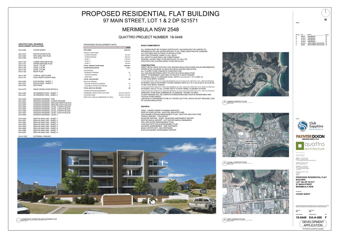
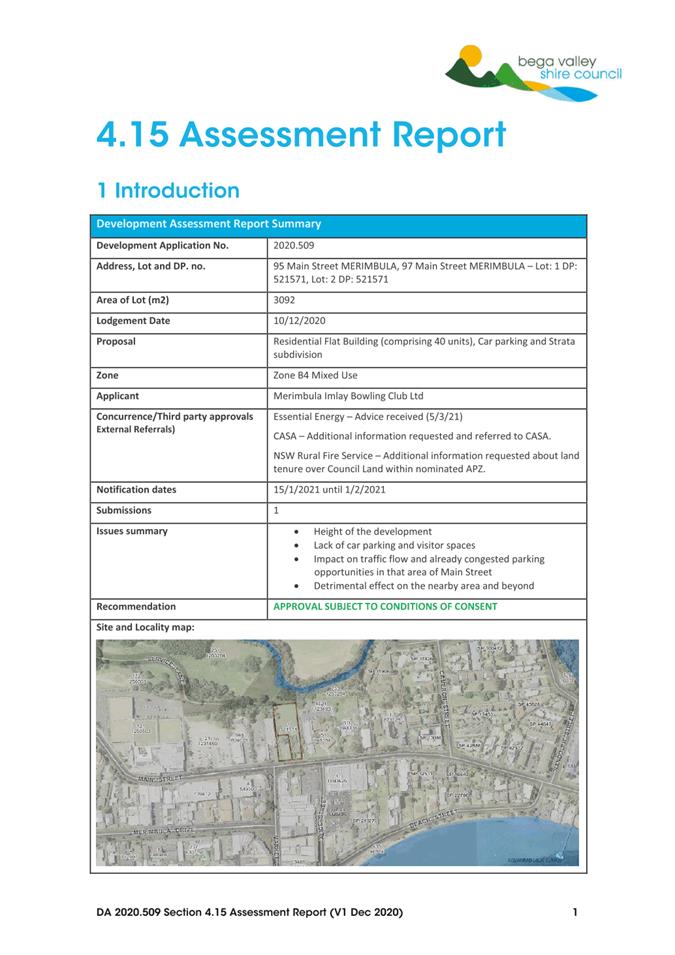
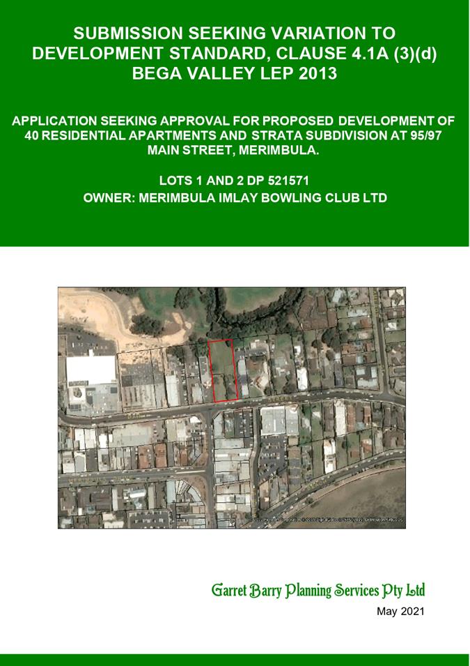
8.1. 2020.509 Residential Flat Building (40 Units) and Strata Subdivision, Lots 1 and 2 DP 521571 - 95-97 Main Street, Merimbula
Director Community Environment and Planning
|
Applicant |
Merimbula Imlay Bowling Club |
|
Owner |
As Above |
|
Site |
Lots 1 and 2 DP 521571 – 95-97 Main Street, Merimbula |
|
Zone |
B4 Mixed Use Zone |
|
Site area |
4,065m2 |
|
Proposed development |
Residential Flat Building (40 Units) and Strata Subdivision |
1. That Council assume the concurrence of the Secretary of the Department of Planning, Industry and Environment in accordance with Circular PS 18-003 and pursuant to Clause 4.6 of the Bega Valley Local Environmental Plan 2013 and notifies the Department accordingly.
2. That Council approve the variation to the height of building development standard, specified under Clause 4.3(2) of the Bega Valley Local Environmental Plan 2013.
3. That Council approve the variation to the minimum site area for residential flat buildings under Clause 4.1(A)(3)(d) of the Bega Valley Local Environmental Plan 2013.
4. That Council approve development application 2020.509 for Residential Flat Building (40 Units) and Strata Subdivision subject to the conditions of consent provided in Attachment 3.
5. That those who made a submission be notified of Council’s determination.
The development application is being reported to Council for determination as the application seeks to vary the current site density development standard specified by the Bega Valley Local Environmental Plan 2013 (BVLEP 2013).
The reporting of this application to Council for determination is consistent with requirements under Planning Circular PS 18-003 as the variation sought is greater than 10% and Council officers do not have delegation to determine the variation.
The proposal also seeks variations to the height and car parking requirements.
The proposal has been assessed under Section 4.15 of the Environmental Planning and Assessment Act 1979. The variation to the height limit is minor and considered reasonable within the context of the site and the surrounding streetscape. The variation to the minimum site area is consistent with a Council-endorsed planning proposal to remove this requirement from BVLEP 2013. The car parking requirements are considered to be consistent with the Roads and Maritime Service (RMS) Guideline for Traffic Generating Development.
The development aligns with the adopted strategic direction that encourages the consolidation of residential land within our town centres, as reinforced in Council’s adopted Local Strategic Planning Statement (LSPS).
The proposed development is recommended for approval, subject to the conditions of consent provided in Attachment 3.
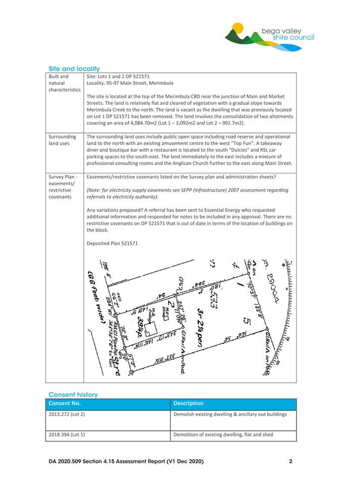
The site is currently vacant and consists of two allotments (Lots 1 and 2 DP 521571) that were historically occupied by two single dwelling houses that have since been removed under separate development applications (2013.272 and 2018.394). The property is located within the Merimbula town centre where height limits were increased when Bega Valley Development Control Plan 2013 (BVDCP 2013) and BVLEP 2013 were adopted. The site is located within the B4 Mixed Use Zone on the northern side of Main Street where the height limit was raised from 10m to 16m to provide greater development opportunities for this land.
Description of the site
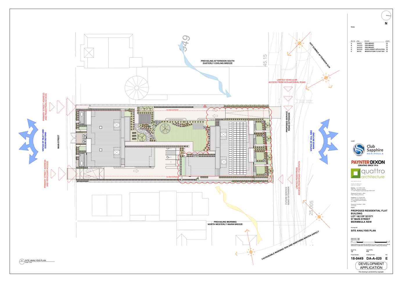
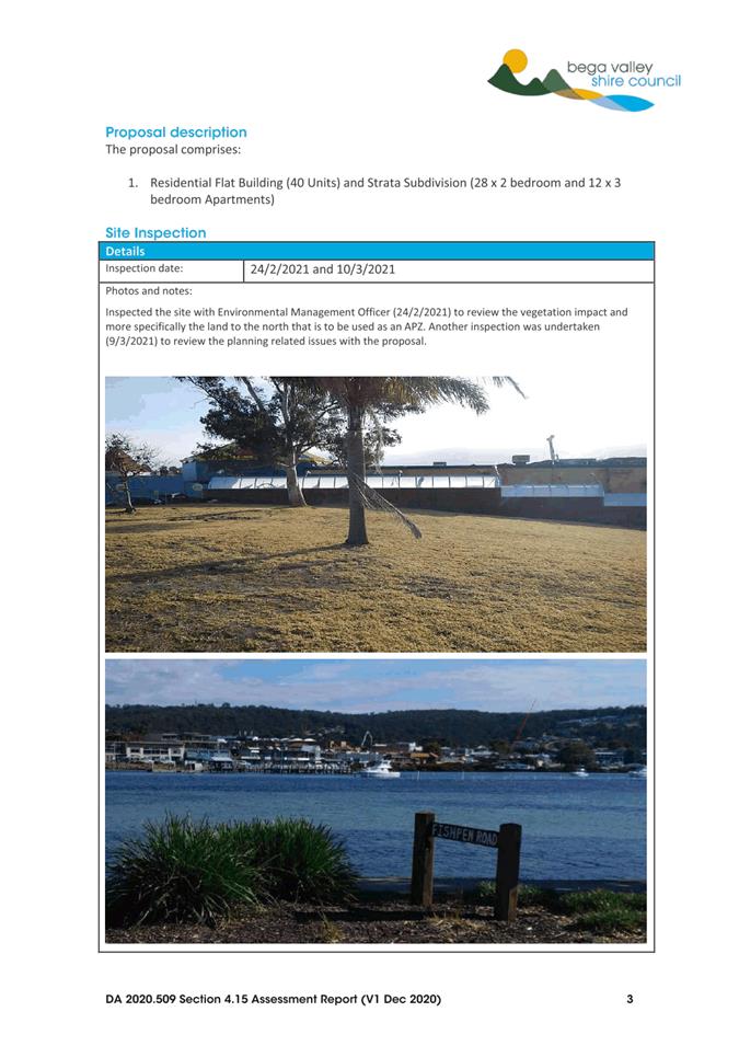
The site (Figure 1) covers an area of 4,065m2 that is relevantly flat with a gentle slope to the north. The land is predominantly cleared; however, some remnant native and exotic trees remain (Figure 2). The property is located near the junction of Main and Market Street, with Top Fun amusement centre to the west and professional consulting rooms to the east.
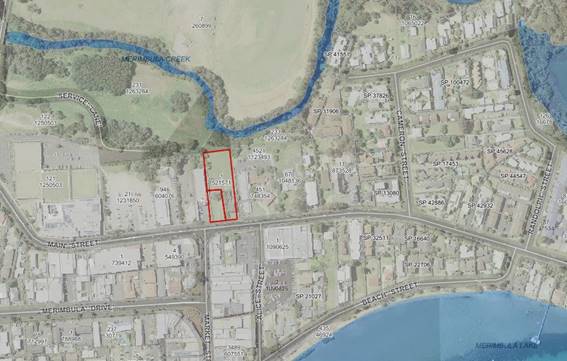
Figure 1 – Locality plan
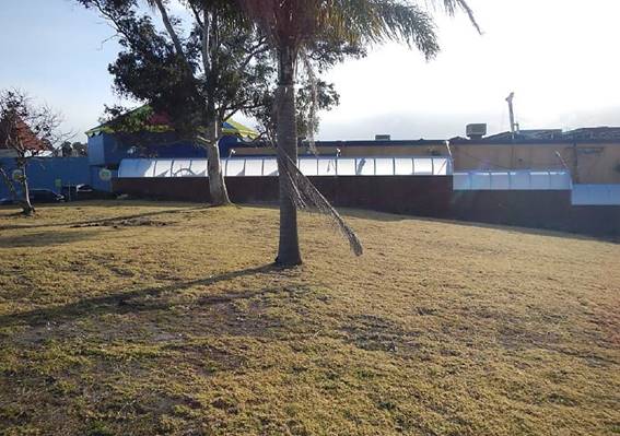
Figure 2 – View of the site
Description of the proposal
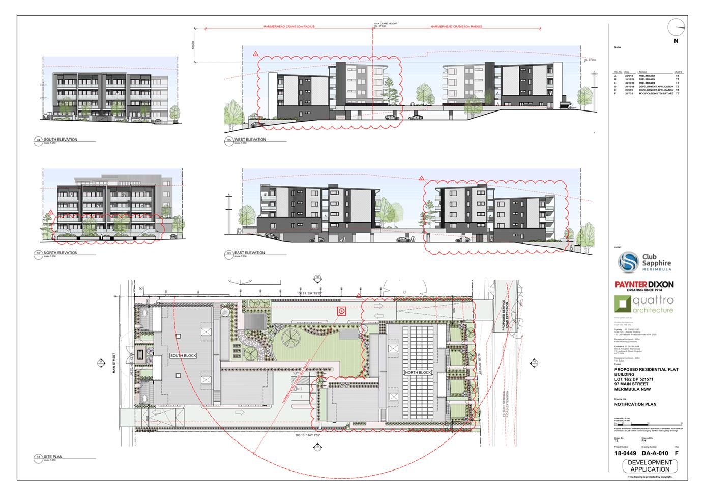
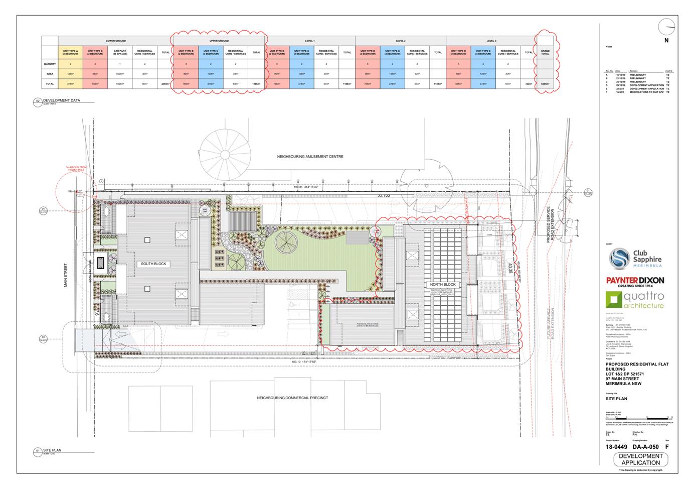
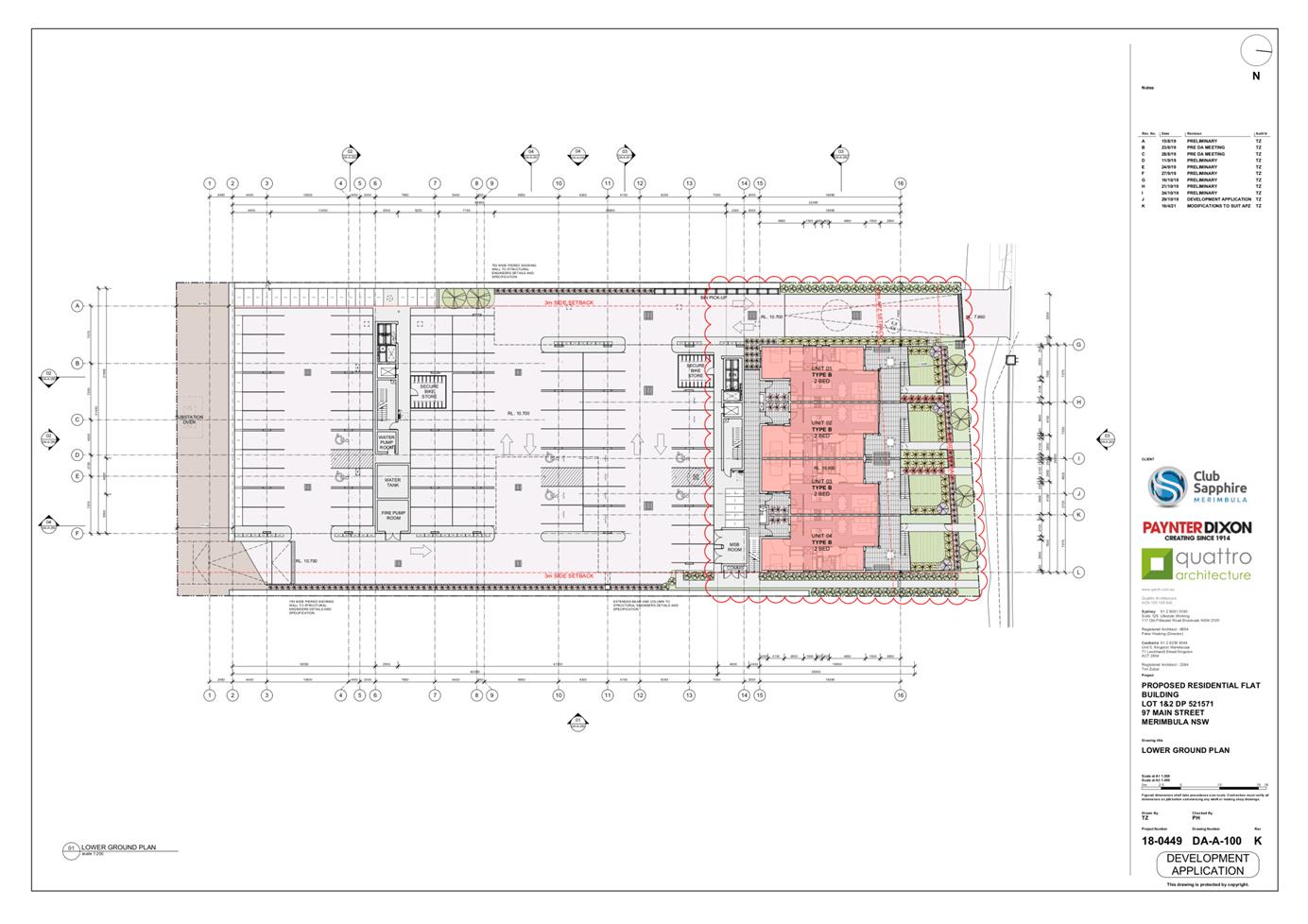
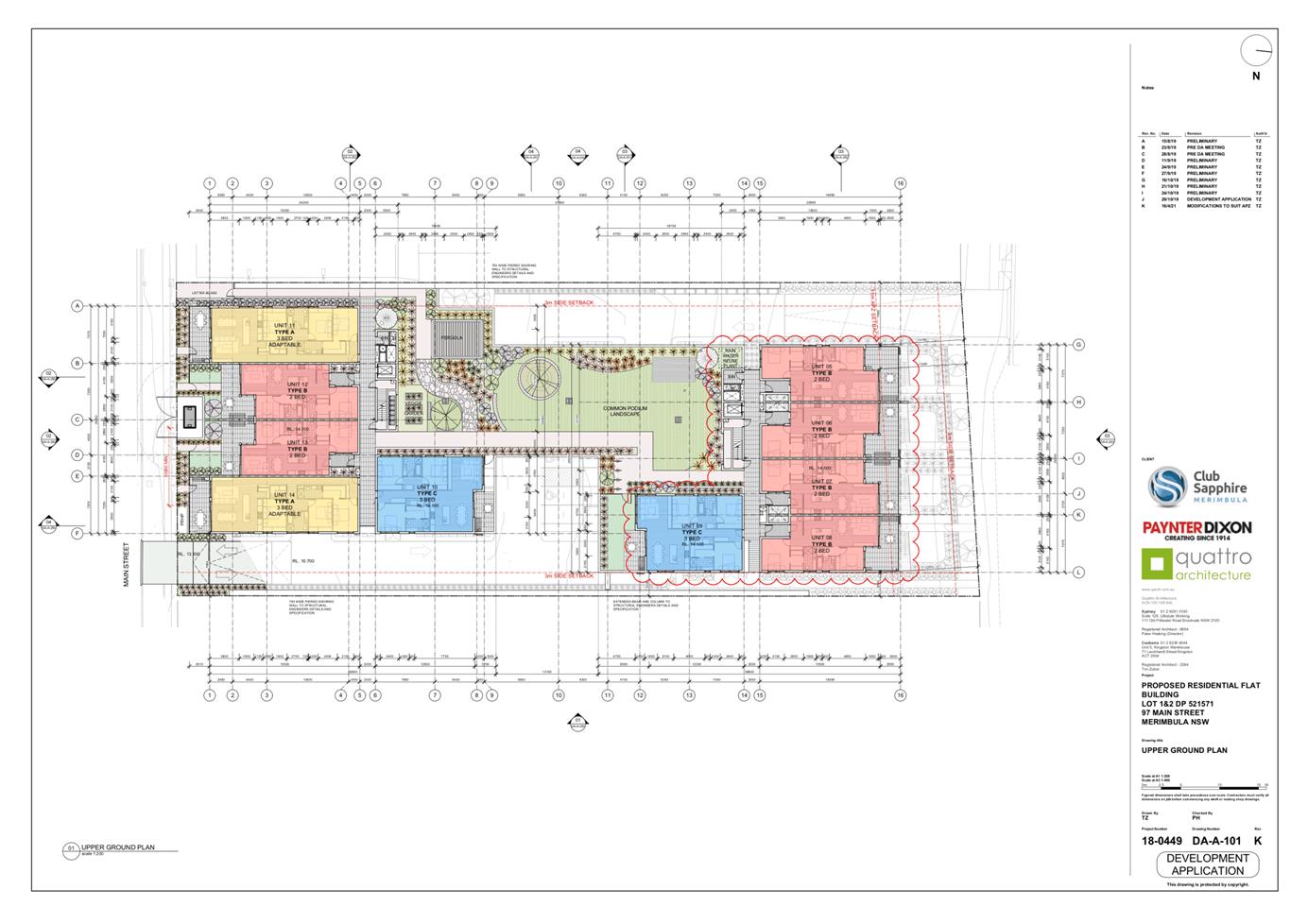
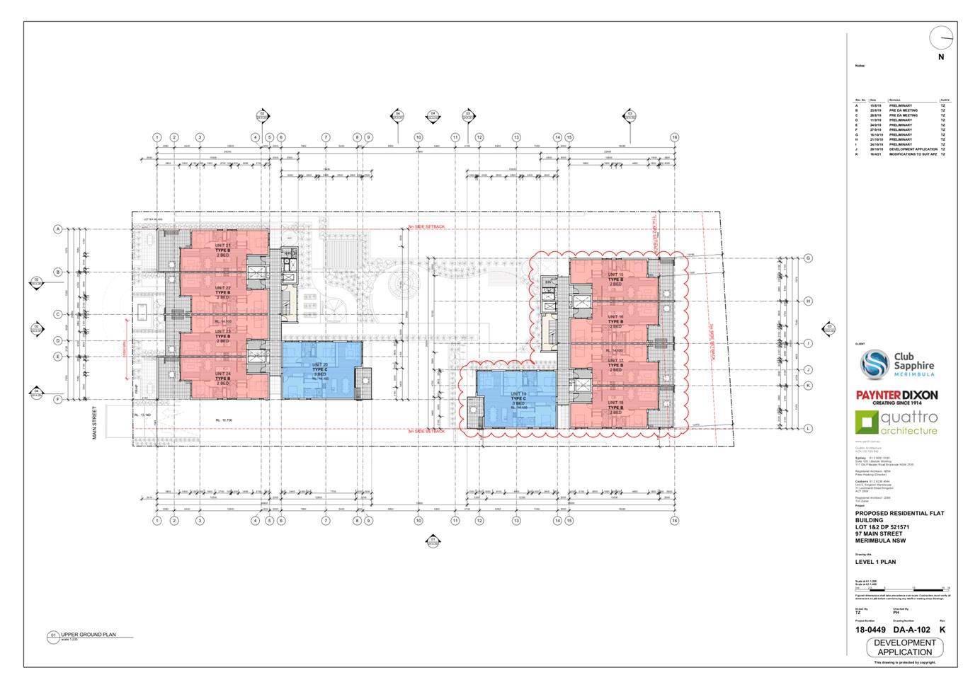
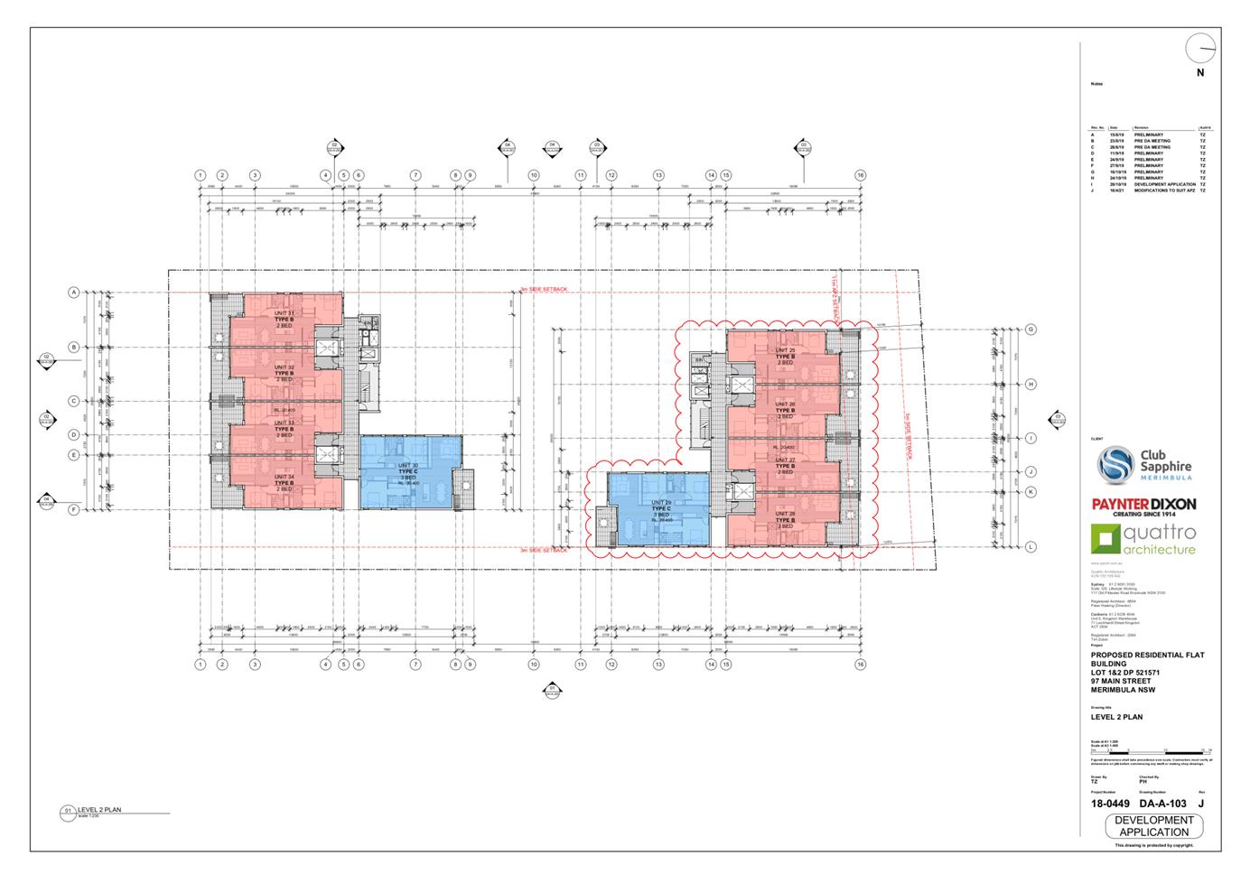
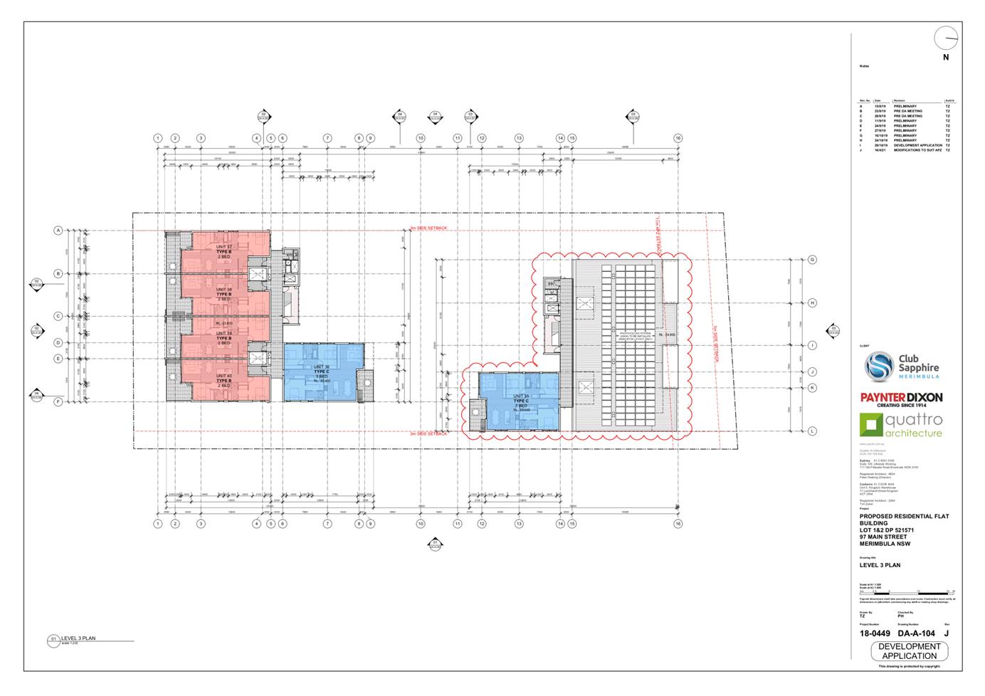
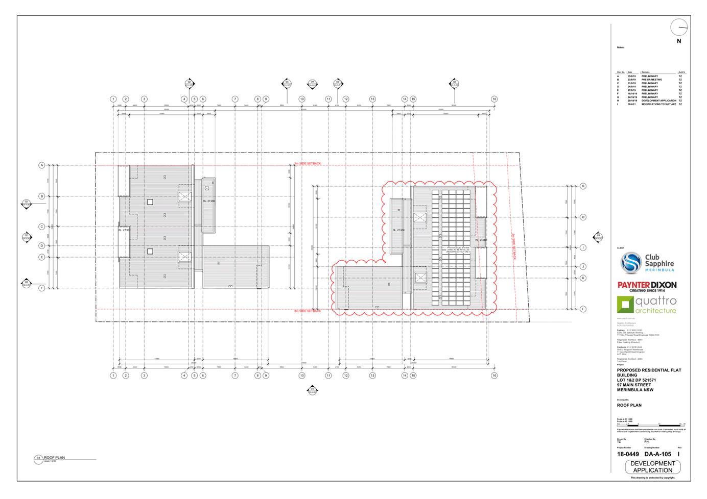
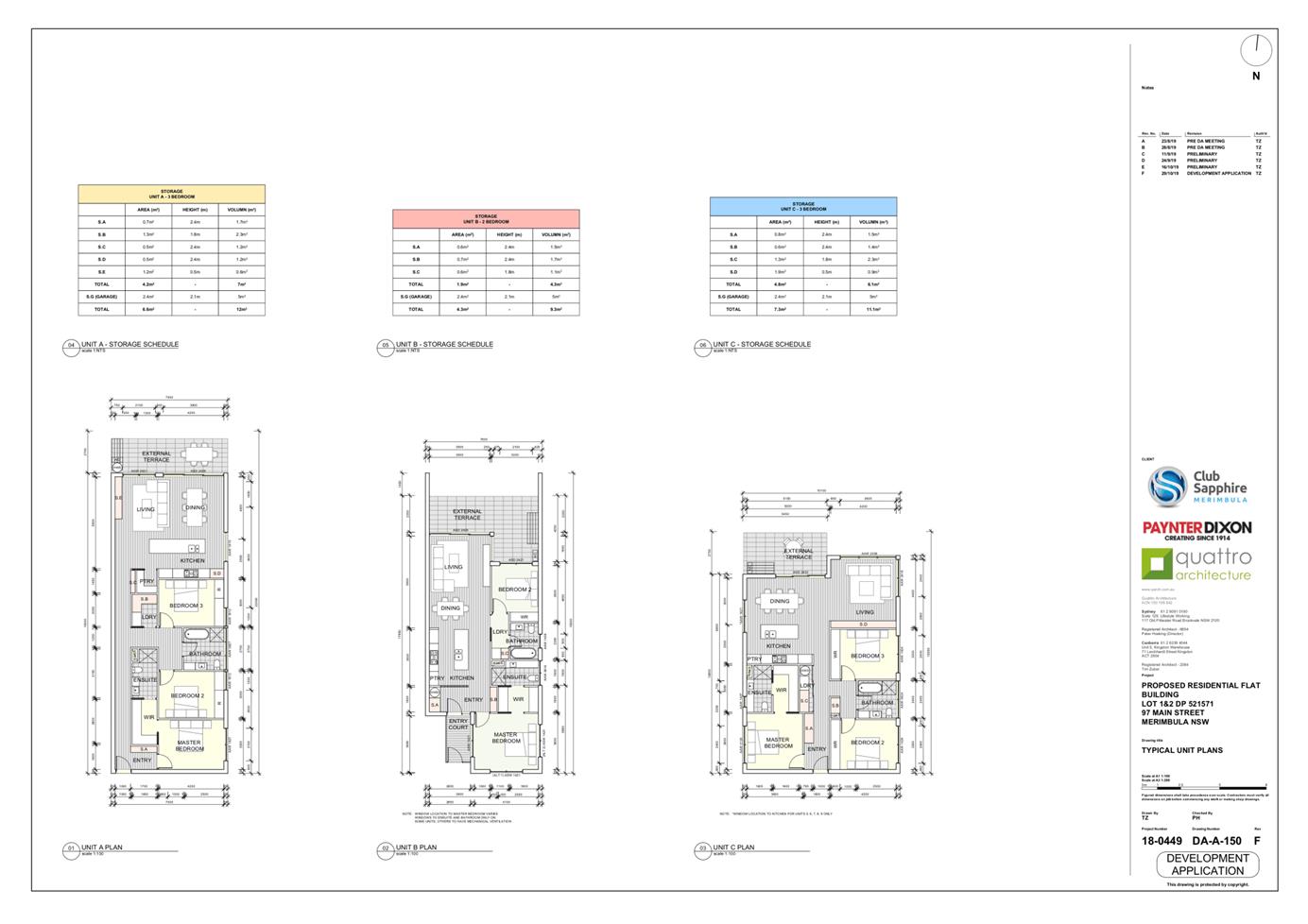
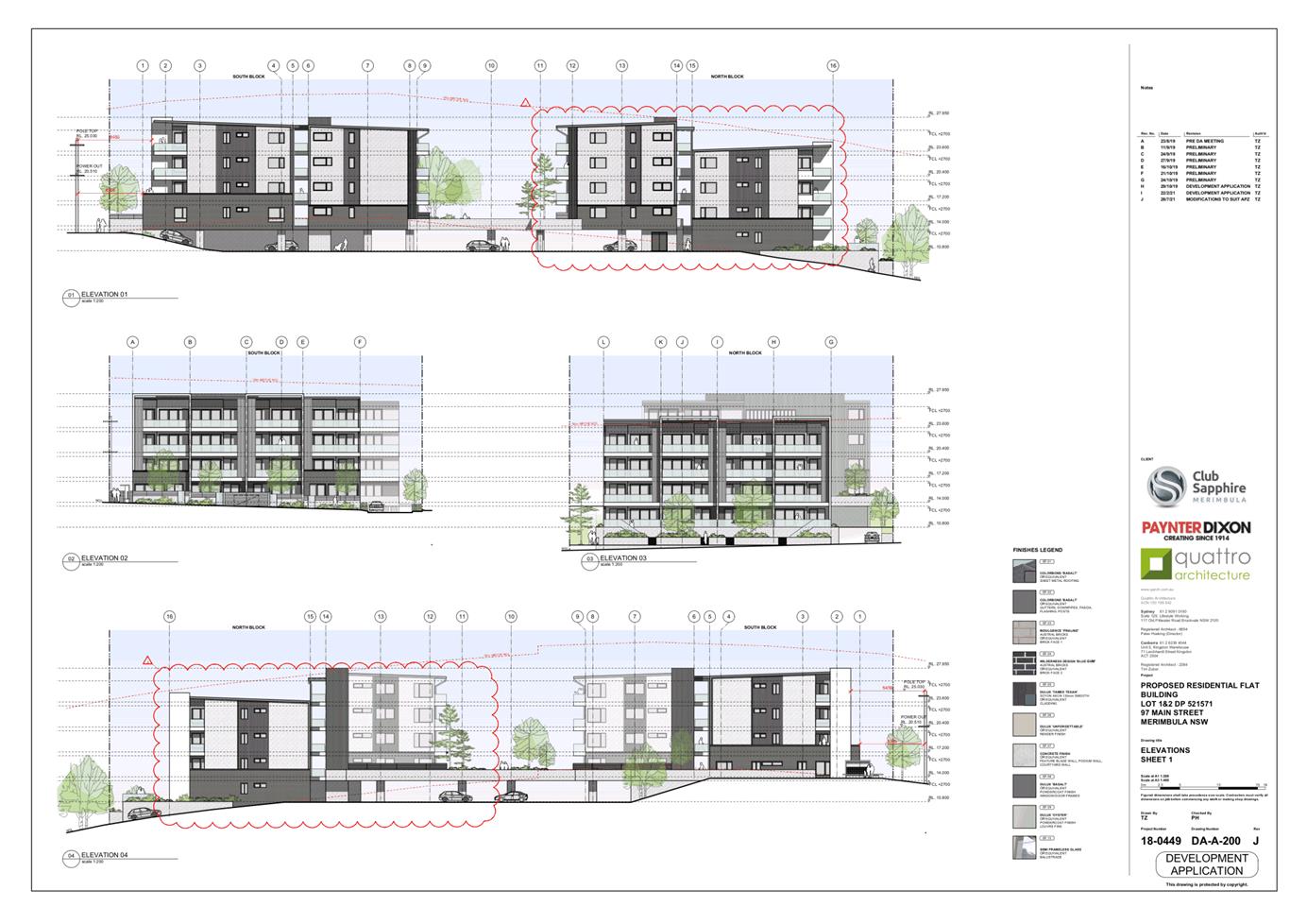
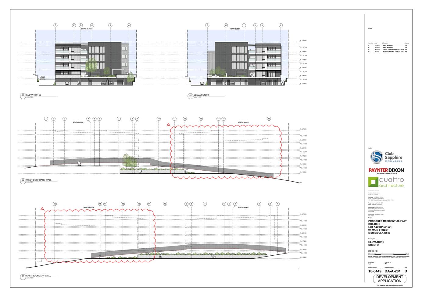
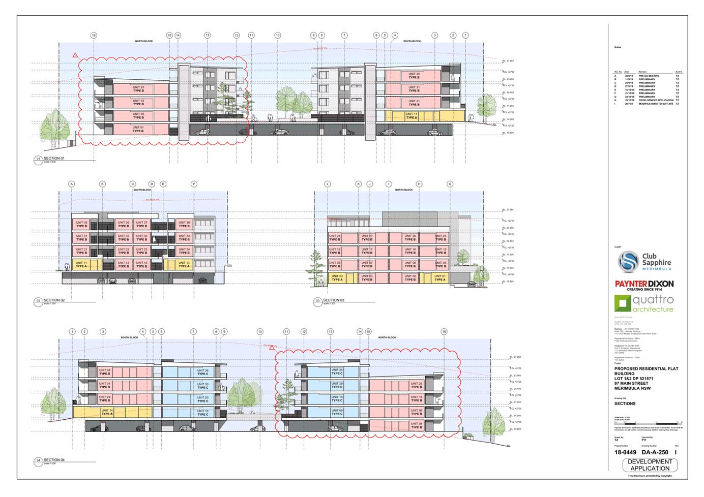
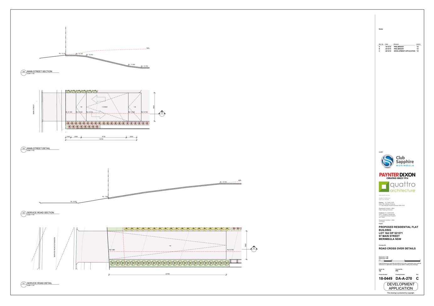
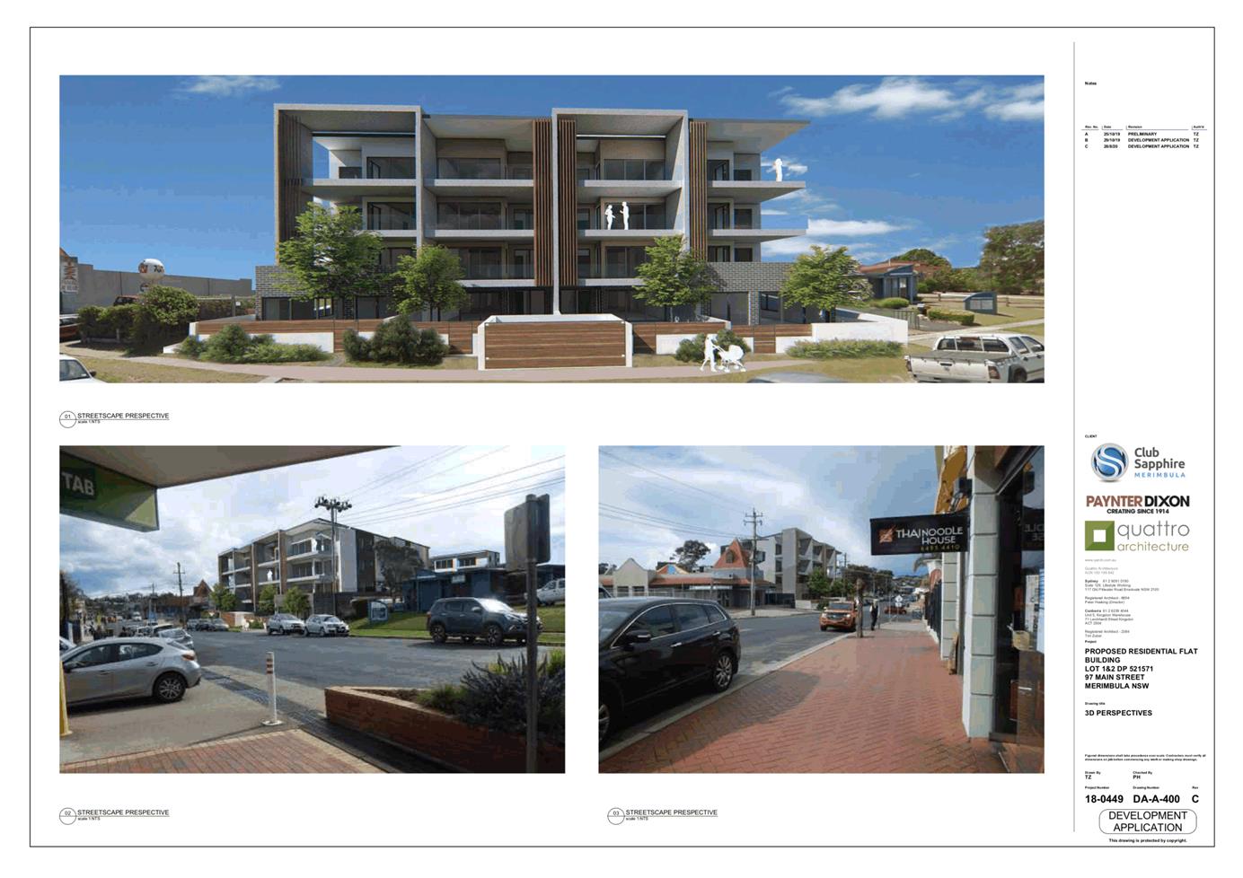
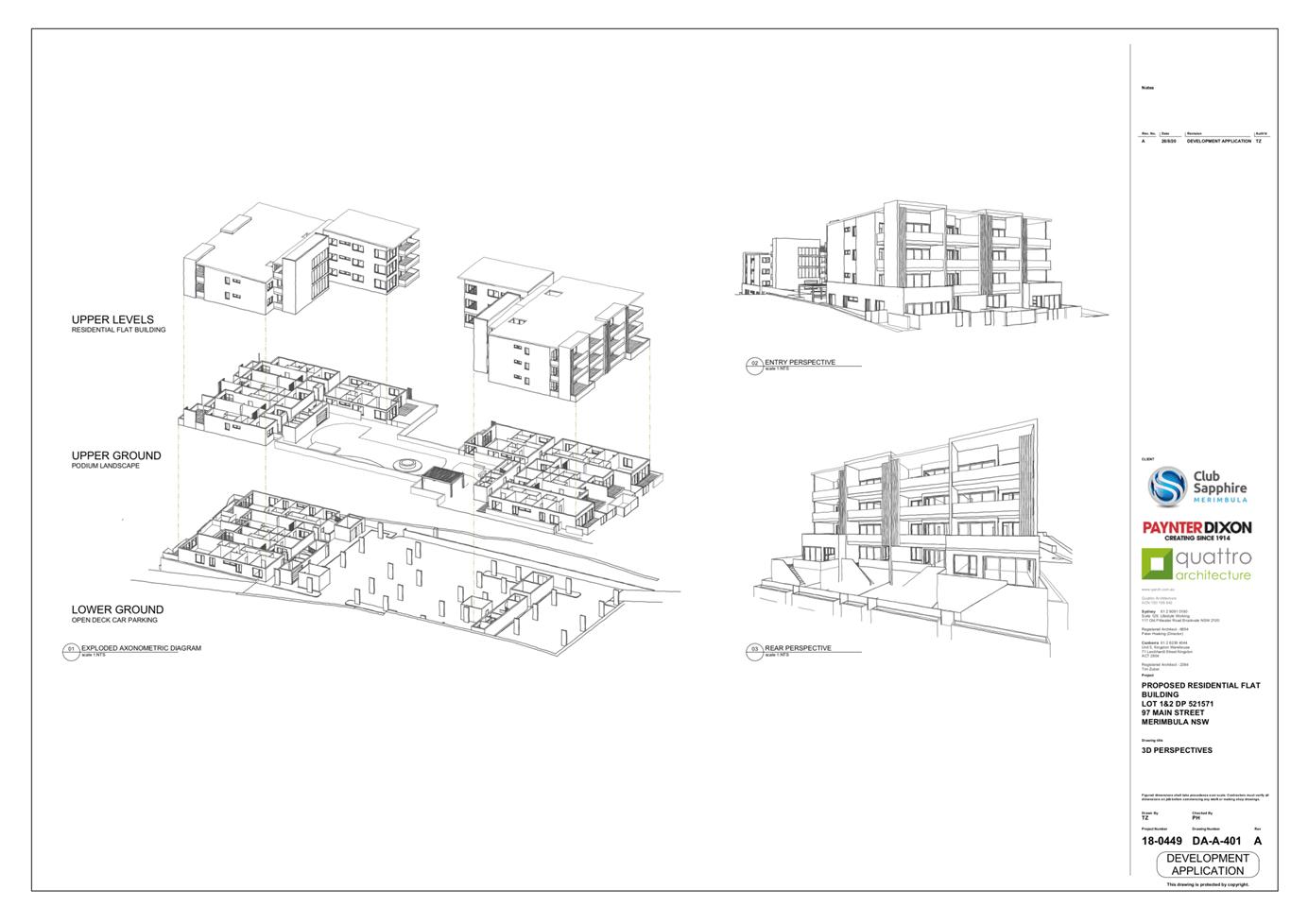
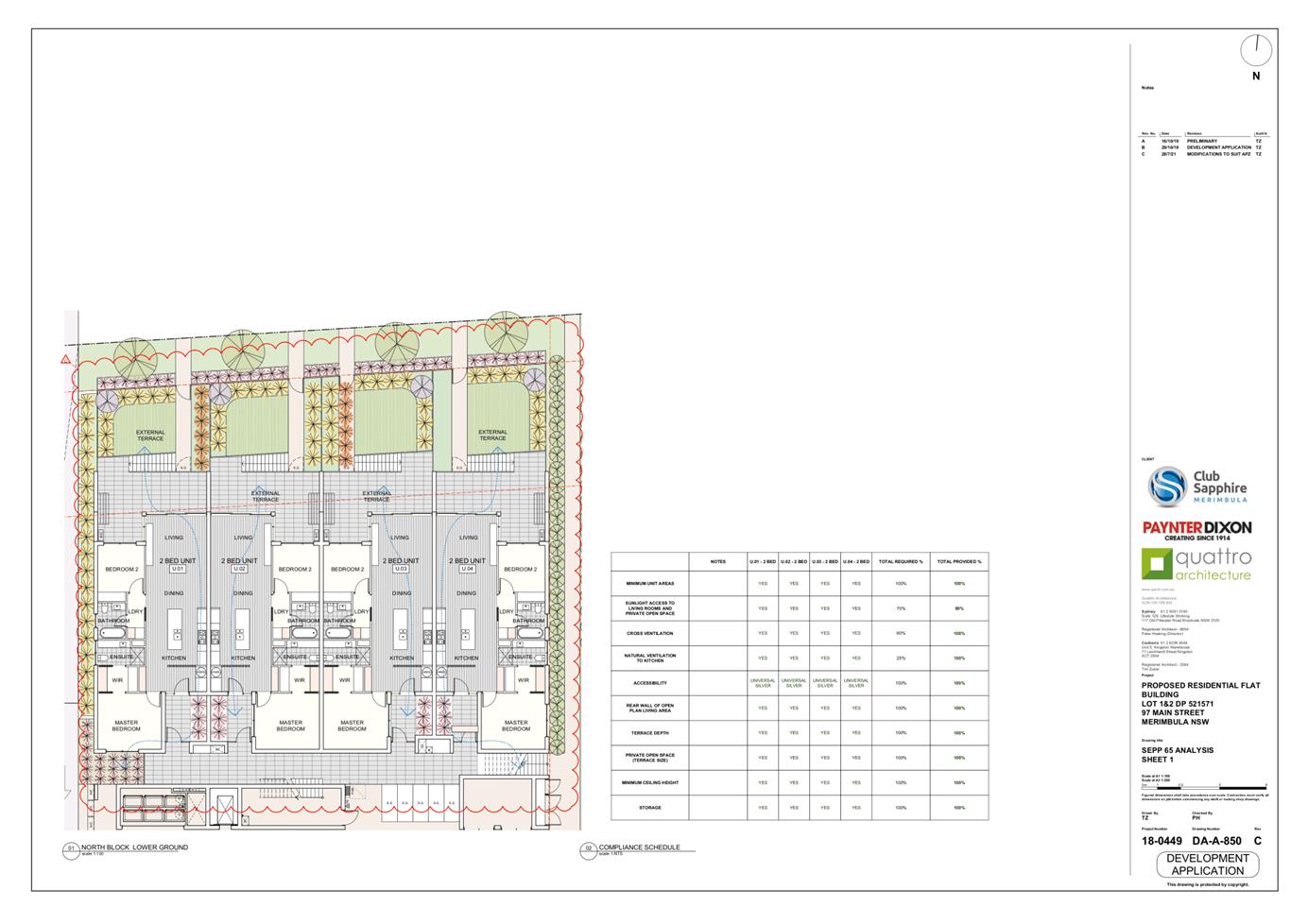
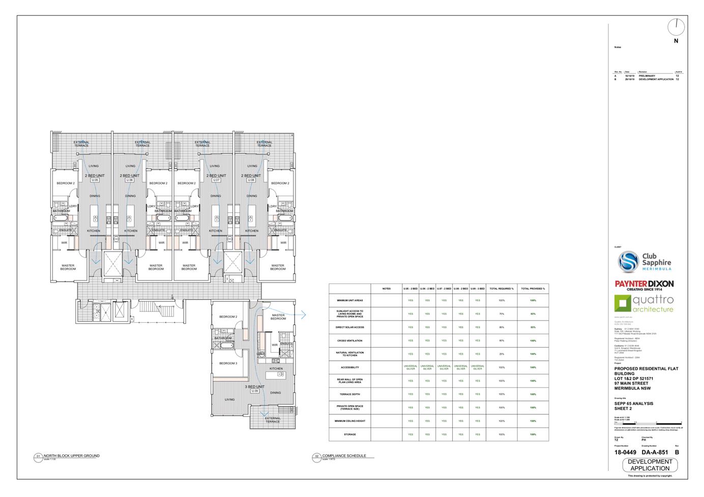
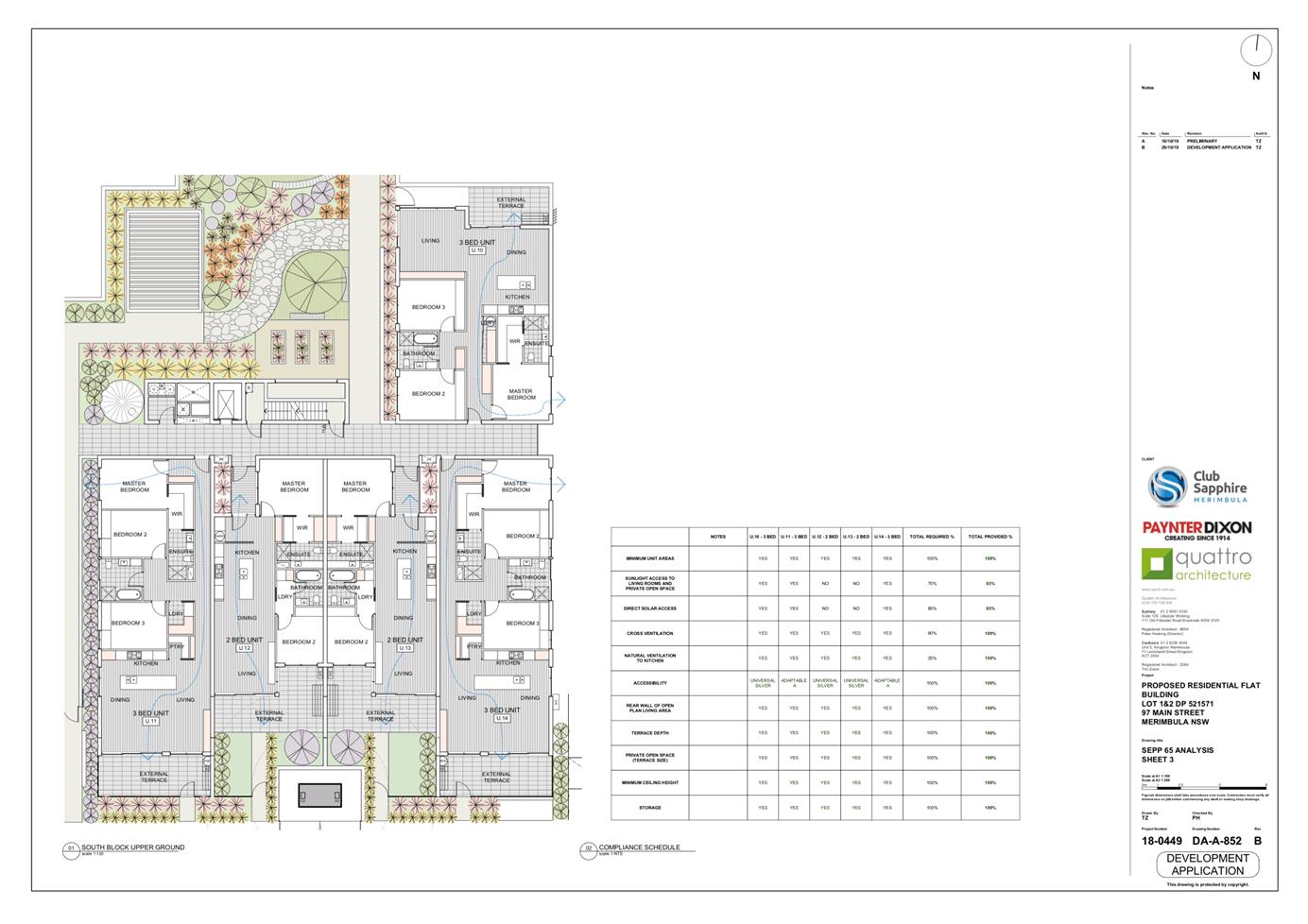
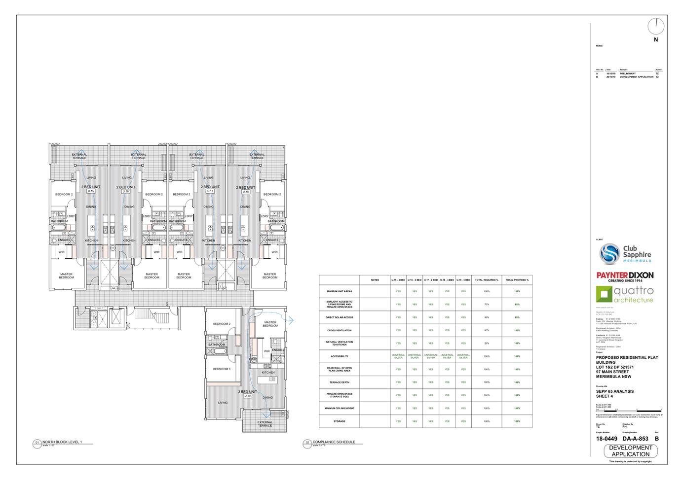
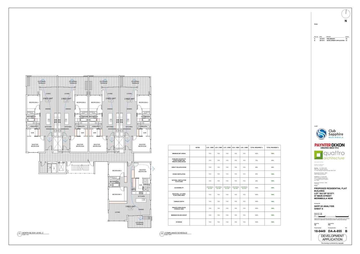
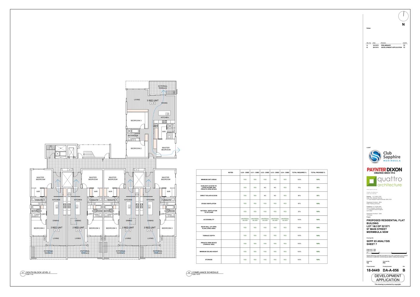
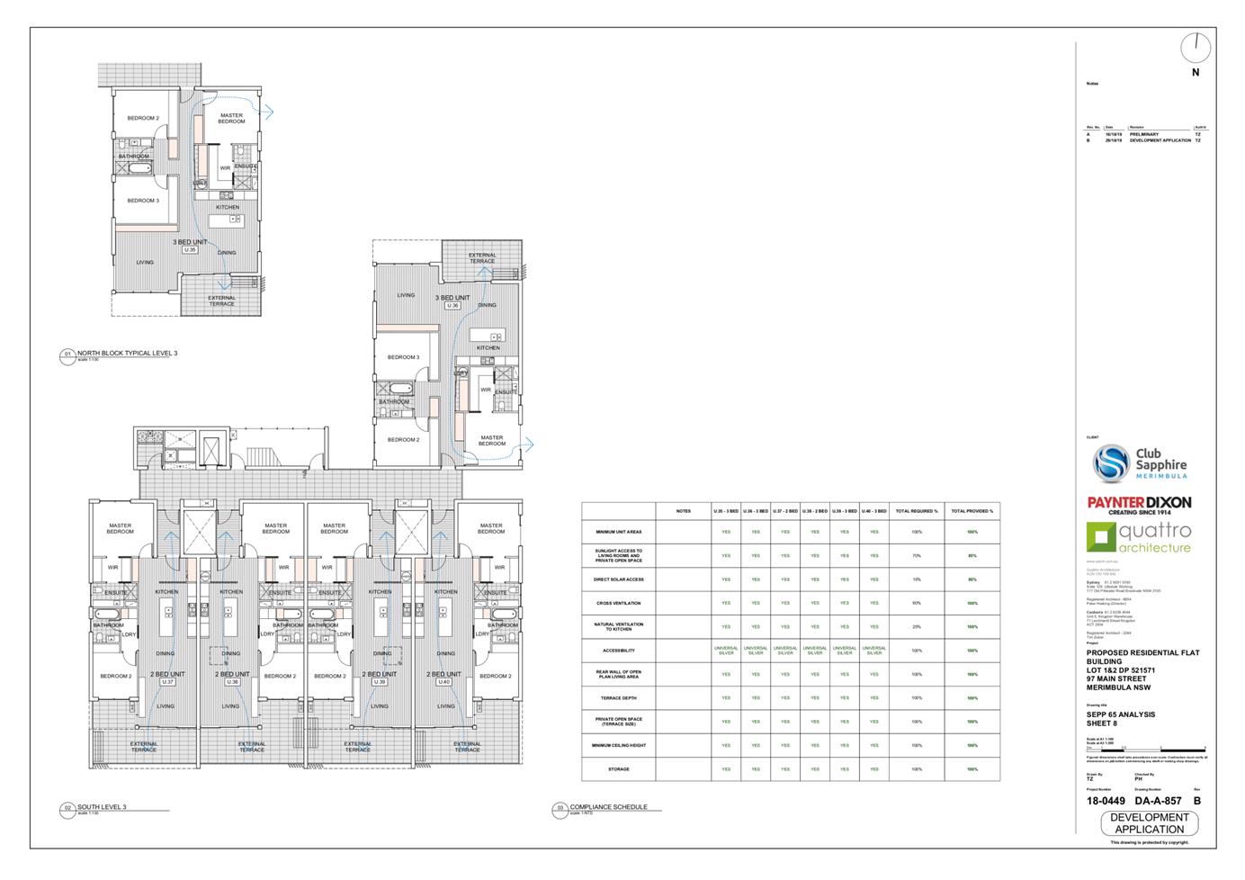
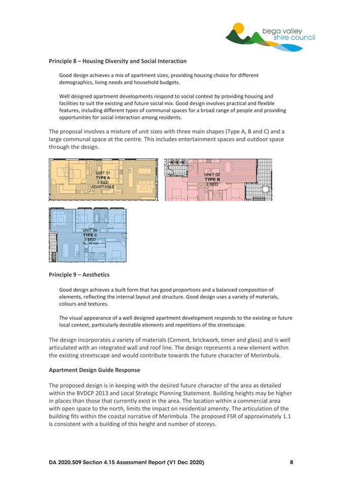
The proposal involves the construction of a residential flat building over five levels consisting of 28x2 bedroom dwellings and 12x3 bedroom dwellings. Car parking is proposed at the lower ground floor level. The principal access is proposed from Main Street, with a secondary access from the rear access road (see Attachment 1 – Proposed Plans and Figures 3 and 4).
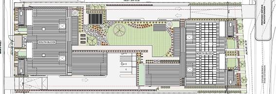
Figure 3 – Development footprint
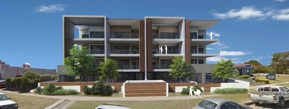
Figure 4 – Development perspective
Planning Assessment
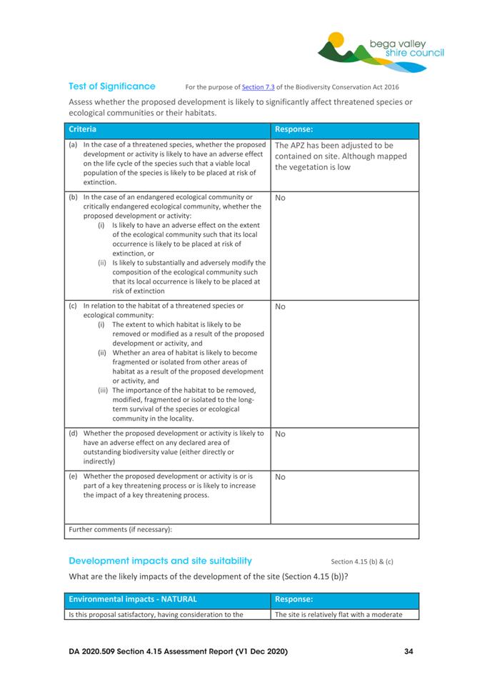
The proposal has been assessed in accordance with the matters for consideration under Section 4.15 of the Environmental Planning and Assessment Act 1979 (Attachment 2). There has been some minor adjustment to the originally submitted plans to provide an asset protection zone (APZ) within the property boundary.
A submission was received during the notification process raising concern about the overall size of the development in terms of height and the lack of parking and potential traffic generation. That submission is addressed later in this report.
Bega Valley Local Environmental Plan 2013
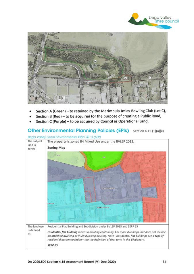
The development has been assessed in accordance with BVLEP 2013. The land is zoned B4 Mixed Use (Figure 5) and is located on the north-eastern edge of the Merimbula town centre. The proposed residential flat building consists of 40 units and does not require or include a commercial component.
The following definition applies:
residential flat building means a building containing 3 or more dwellings but does not include an attached dwelling or multi dwelling housing.
Height and storeys
The 16-metre height limit currently applies to the site under Clause 4.3, which is measured from “existing ground level” to the highest point of the building. Building height is defined as follows:
Building Height (or height of building) means—
(a) in relation to the height of a building in metres—the vertical distance from ground level (existing) to the highest point of the building, or
(b) in relation to the RL of a building—the vertical distance from the Australian Height Datum to the highest point of the building, including plant and lift overruns, but excluding communication devices, antennae, satellite dishes, masts, flagpoles, chimneys, flues and the like.
The design includes a lift overrun that would encroach above the 16m height limit of between 300mm to 650mm (Figure 6). A request to vary the height limit has been received from the applicant.
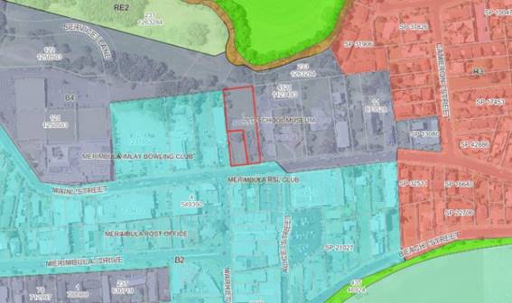
Figure 5 – Zoning map
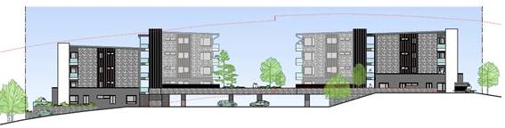
Figure 6 – Elevation and height control
Site Density
The proposal is subject to a site density development standard requiring 1 dwelling per 250m2 under Clause 4.1A(3)(d) of BVLEP2013. Strict compliance with the standard would see a maximum yield of 16 dwellings for the site. That is considered well below the yield that could ordinarily be achieved within a 16m height limit and well below the 40 units proposed as part of this proposal. The applicant has therefore requested a variation from this standard.
Variations under Clause 4.6
The application seeks two variations under Clause 4.6, being the 16m height limit under Clause 4.3 and site density control under Clause 4.1A(3)(d). The concurrence of the Secretary of the Department of Planning, Industry and Environment can be assumed for both variations, in accordance with the provisions of Planning Circular PS 18-003.
Council, as the consent authority, may consider variations to development standards (with the use of Clause 4.6 of BVLEP 2013) provided the proposal:
· meets the objectives of the zone, and
· meets the objectives of the development standard, and
· demonstrates that compliance with the standard is unreasonable or unnecessary in the circumstances of the case, and
· demonstrates there are sufficient environmental planning grounds to justify contravening the development standard.
The applicant has provided justification for varying the maximum dwelling separation for the subject site (Attachment 4 – Clause 4.6 Variation Assessment).
Objectives of the zone
The following objectives apply to the B4 Mixed Use Zone:
· To provide a mixture of compatible land uses.
· To integrate suitable business, office, residential, retail and other development in accessible locations so as to maximise public transport patronage and encourage walking and cycling.
The proposed residential flat building is consistent with the characteristics of the area and existing land uses. The site is within the Merimbula town centre and within walking distance of all amenities. The variation to the height limit is minimal and the minimum site density controls currently prevent the development potential of the land being fulfilled.
Objectives of the Development Standard
The following objectives apply to Clauses 4.1B and 4.3:
Clause 4.1A - Minimum site areas for dwelling houses, dual occupancies, multi dwelling housing and residential flat buildings in certain zones
(1) The objective of this clause is to achieve planned residential density in certain zones.
Clause 4.3 – Height of Buildings
(1) The objectives of this clause are as follows:
(a) to retain the existing character and landscape of the locality and to encourage a low-set building form,
(b) to protect residential amenity, views, privacy and solar access.
The site is located within a mixed-use area where the impact on residential amenity is minimal within the context of a development of this scale.
The height limit within this catchment was increased to provided further opportunities for development and the variation to the height control is minimal. The site density controls currently limit the development of this centrally located site contrary to the strategic objectives that encourage the consolidation and further development of residential and commercial land within our town centres.
Whether compliance with the standard is unreasonable or unnecessary
Compliance with the height and site density controls are not considered necessary given the variation to the height control is minimal (lift overrun) and the site density controls are subject to a planning proposal to remove this clause to align with the strategic objectives for the Shire.
The variation to the height control does not impact on the residential amenity of surrounding land uses and limiting the number of units would significantly reduce the yield that would ordinarily be achieved within the building envelope for this site. It is therefore concluded that strict compliance with the nominated development standards would be unreasonable and unnecessary based on the merits of this development.
Whether there are sufficient environmental planning grounds
The site has few environmental constraints, being relatively flat and generally cleared of vegetation. It provides a rare opportunity to develop centrally located land that is unencumbered by existing buildings or ownership.
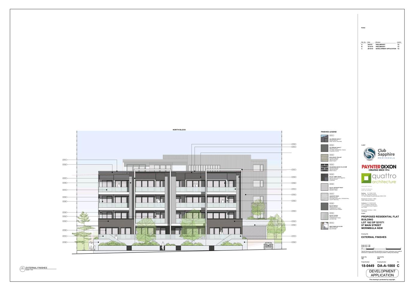
The design has been well articulated and would make a positive contribution towards the existing streetscape on Main Street, Merimbula.
Development Control Plan 2013
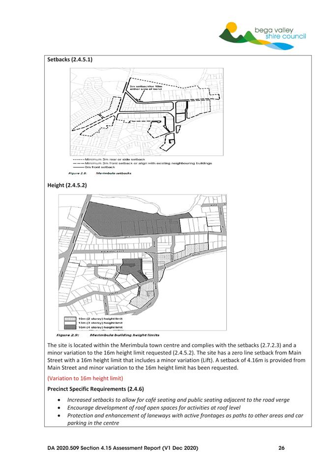
The proposal has been assessed in accordance with BVDCP 2013 and more specifically Chapters 2, 3 and 5 for residential development. The proposal involves a minor variation to the 16m height limit under Clause 2.4.5.2 and a variation to the car parking requirements for residential flat building under Clause 5.9.
Design
The bulk and scale of the development is broken up into two main buildings with a landscaped area at the centre. The design incorporates natural materials in a colour scheme that reflects that coastal location. The balconies are integrated into the overall façade and help to balance the vertical and horizontal elements of each building.
The site is currently vacant and bordered by commercial land to the west and a streetscape on the high side of Main Street that consists of the Top Fun amusement centre immediately adjoining, Woolworths, Club Sapphire and the Aldi development that is currently under construction. The mixed-use land to the east consists of professional consulting rooms, Anglican Church, Dulcie’s Cottage, Merimbula RSL and larger residential unit complexes further to the east.
The height and number of storeys would be prominent within the streetscape given its setting among existing single storey buildings at the top of Market Street near the junction with Main Street. The site is, however, centrally located within an area that is in need of development. Within this context the minor variation to the 16m height limit under Clause 2.4.5.2 is considered reasonable.
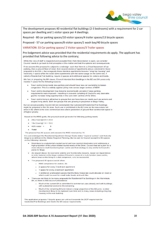
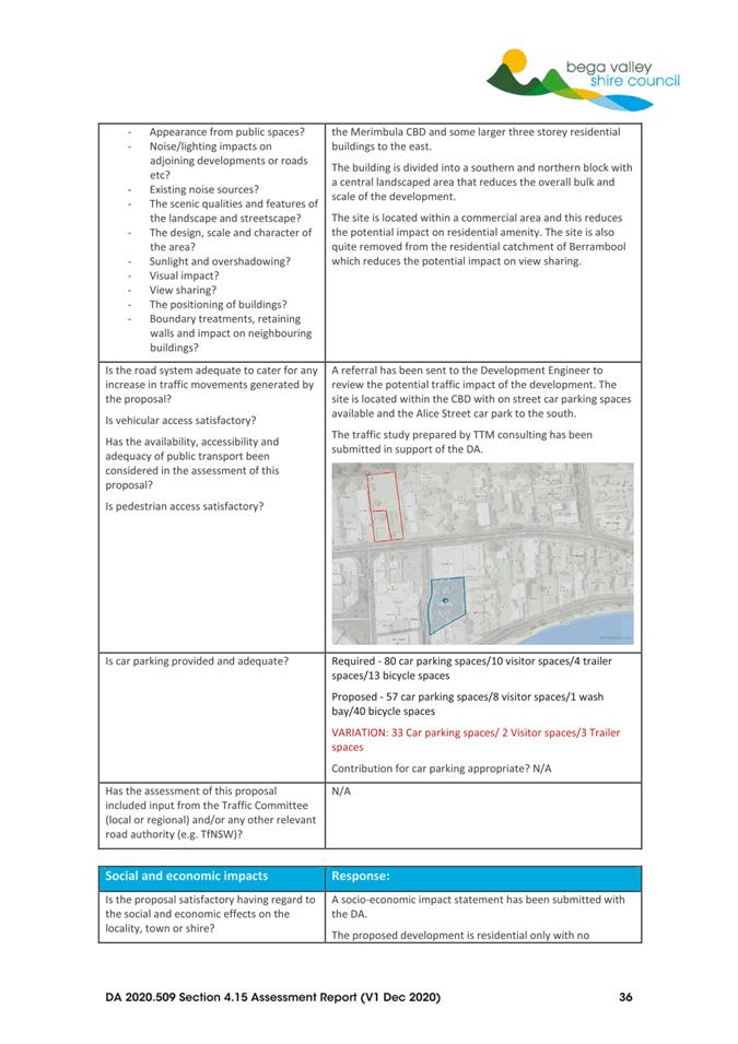
Parking
The following parking is proposed:
· 57 car spaces
· 8 visitor spaces
· 1 wash bay
· 40 bicycle spaces
The parking required by the DCP for 40 residential flat buildings (2-3 bedrooms):
· 80 car paces
· 10 visitor spaces
· 4 trailer spaces
· 13 bicycle spaces
The applicant has provided justification for the variation based on proposed compliance with the RMS Guide to Traffic Generating Development that requires parking at the following rate:
· 23.4 car spaces for 26x2 bed units at a rate of 0.9
· 19.6 car spaces for 14x3 bed units at a rate of 1.4
· 8 visitor spaces at a rate of 0.2
Although these standards apply to regional centres under the Residential Apartment Design Guide (eg Bega), it is argued that the site is located next to the commercial centre of Merimbula, which is a substantial residential and tourist destination and the provision of parking at the nominated rate would make the project unviable. The parking requirements relate to the definition of the units as a ‘residential flat building’ within the B4 Zone. A variation to this requirement under Table 5.5 of Chapter 5.9 of BVDCP 2013 is considered reasonable given the central location of the site that is within walking distance of the town centre and given all other residential development including dwellings, dual occupancies, shop top housing with multiple units and multi dwelling housing are levied at a rate of 1 space for dwelling.
Staff will review current parking requirements under the DCP as a separate matter.
Amenity
The proposed development site is located on the eastern edge of the commercial town centre with open space to the north and existing commercial development either side. This significantly reduces the impact on residential amenity.
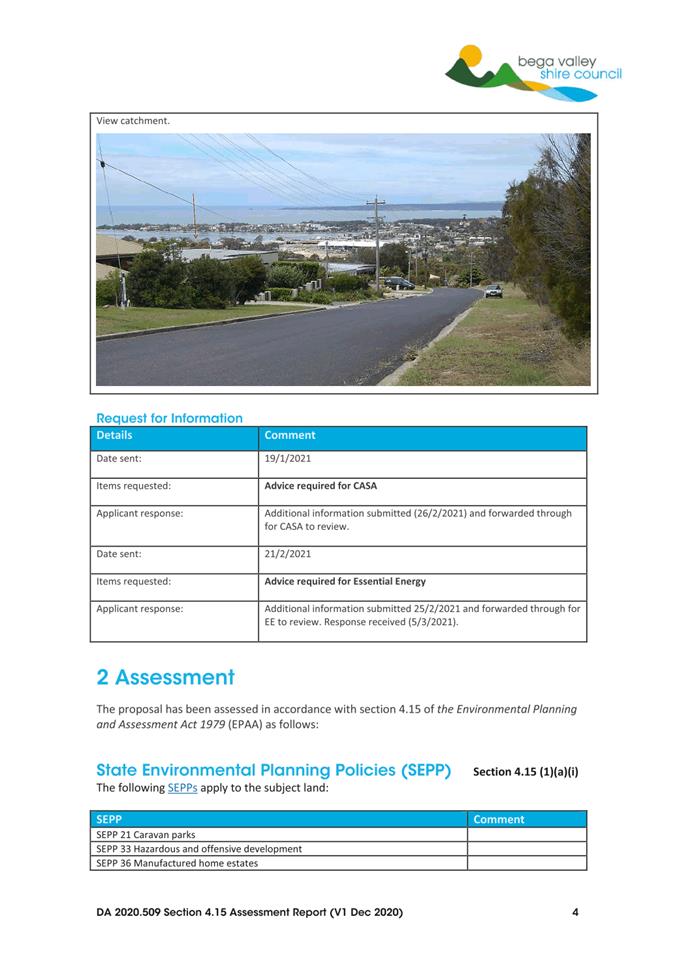
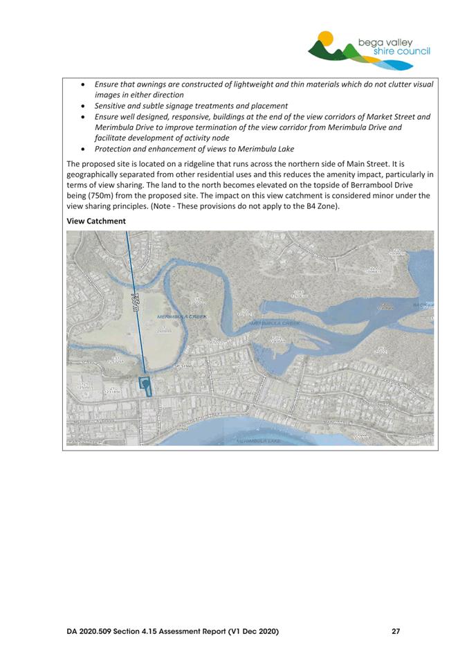
Views
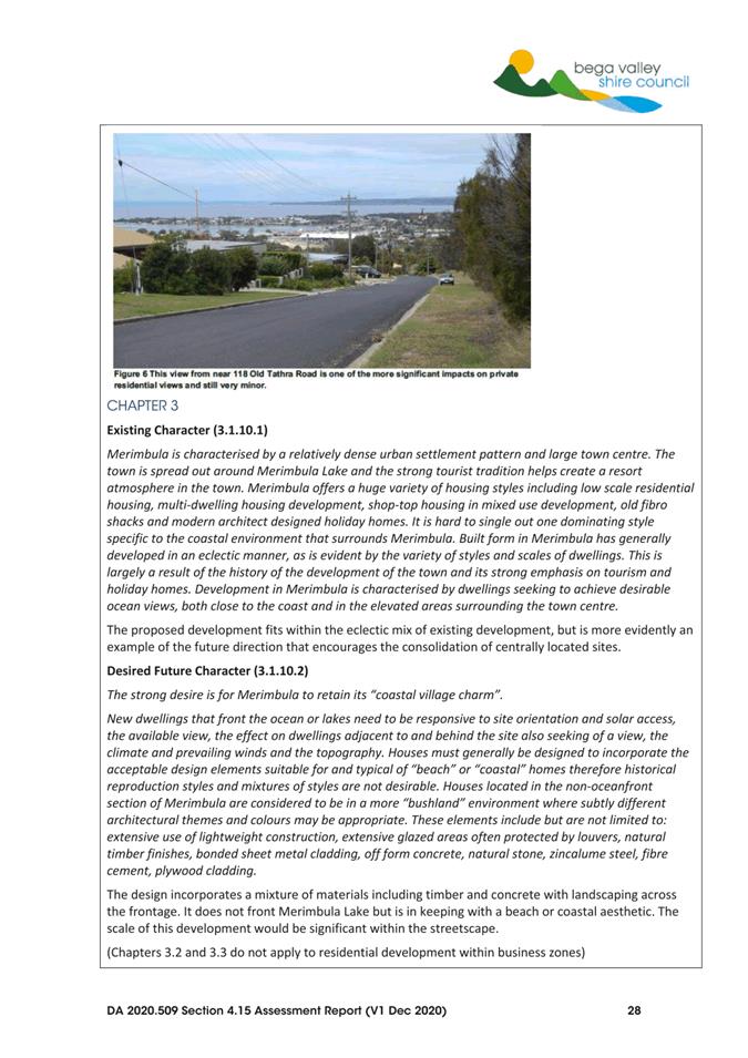
The land is setback from Merimbula Lake and some distance from the broader view catchment along Berrambool Drive and Old Tathra Road to the north-west (eg Figure 7). The impact is considered minor within the context of the view catchment and there are limited opportunities to reduce this impact given the prevailing 16m height control across the northern side of Main Street.
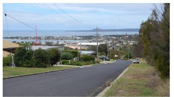
Figure 7 – View catchment from Old Tathra Road
Environment
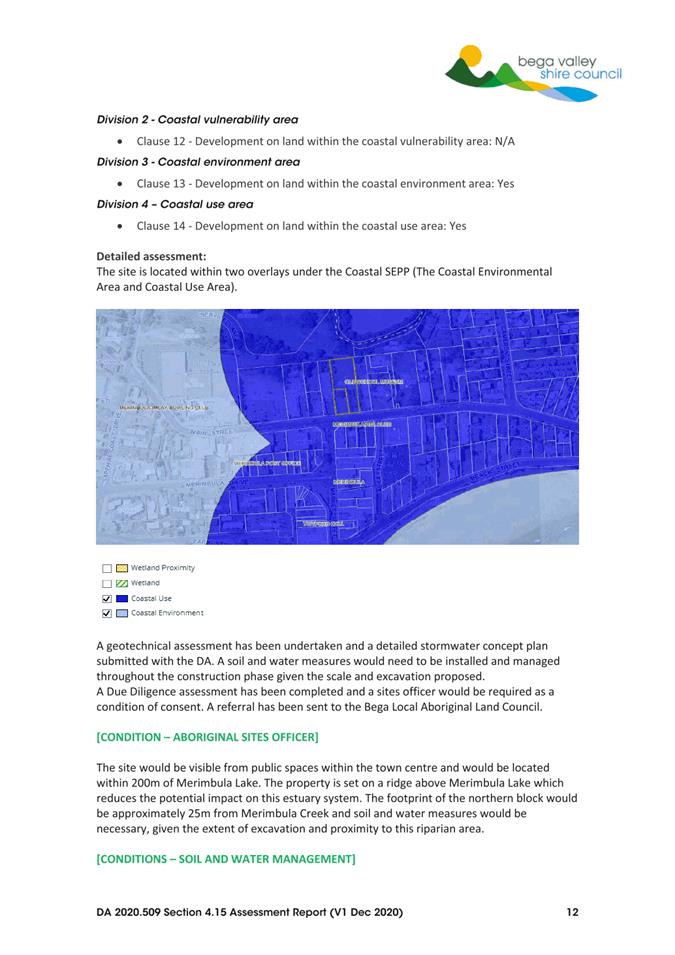
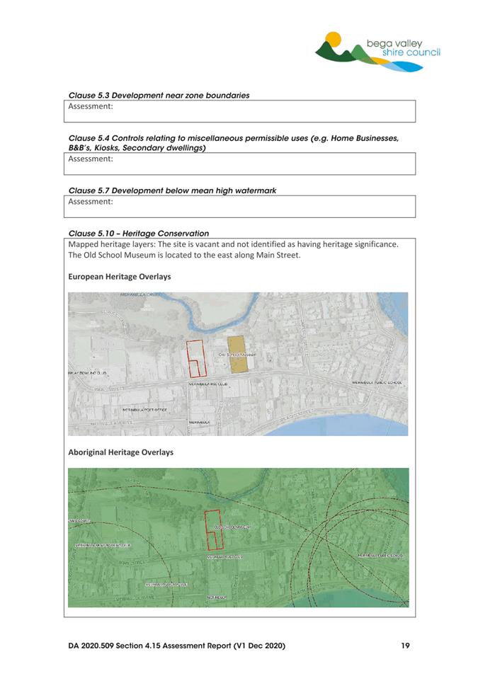
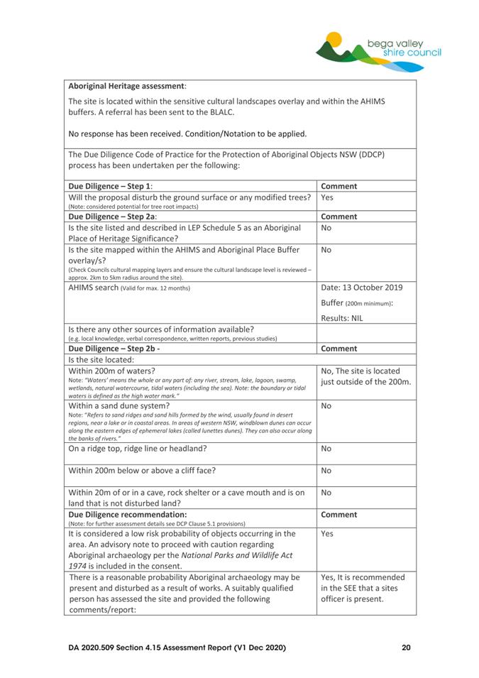
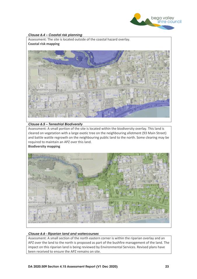
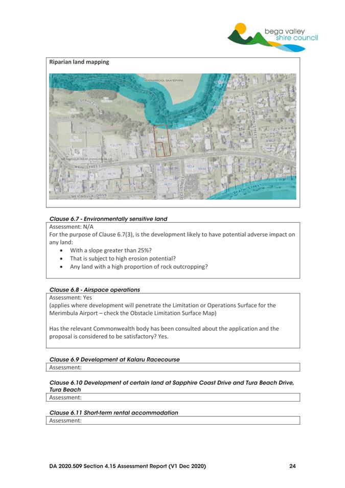
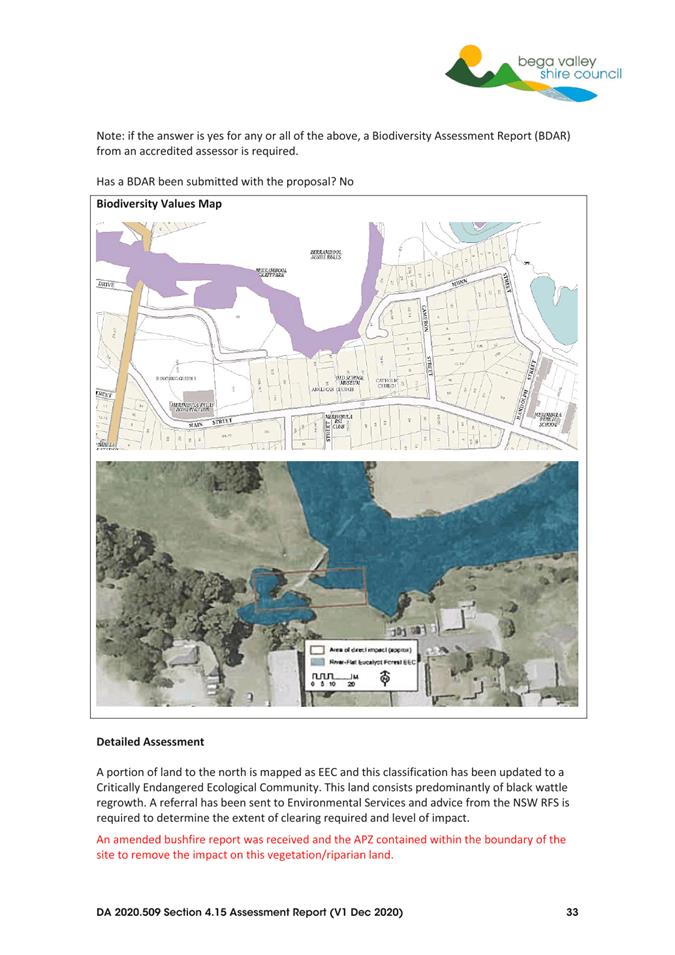
The site is cleared with some remnant native and exotic trees on relatively flat land that is setback from Merimbula Lake. Merimbula Creek is located to the north. Potential impact on the prevailing coastal environment and Aboriginal archaeology is considered to be negligible.
The vegetation along the creek to the north (Figure 8) is included as part of the endangered ecological community River-Flat Eucalypt Forest on Coastal Floodplains of the New South Wales North Coast, Sydney Basin and South East Corner Bioregions listed under the Biodiversity Conservation Act 2016. This land was originally included as part of an APZ that has since been setback to ensure the APZ is contained within the property boundary and ensure the development does not impact this vegetation.
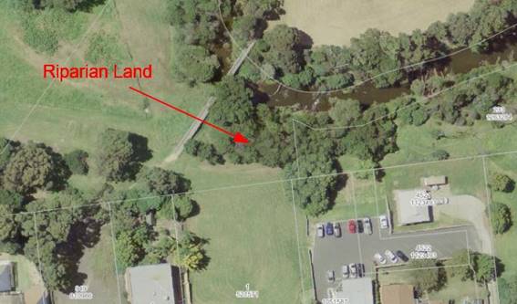
Figure 8 – Riparian land to the north
State Environmental Planning Policies
SEPP 65 – Design Quality of Residential Development and the Apartment Design Guide apply to this development application.
The design quality SEPP applies given it is three storeys or more above ground level and the building contains at least four or more dwellings. A Design Verification Statement that includes a response to the Apartment Design Guide has been provided by the applicant.
The site is located on the eastern edge of the Merimbula commercial town centre. The streetscape is defined by a mixture of commercial and residential land uses that vary from single storey to three storeys in height. The proposed four storey development is the first development the 16m height limit that was introduced as part of the BVDCP 2013 and BVLEP 2013. The development introduces a new building element into the streetscape along Main Street in terms of overall height and scale. The design is therefore critical as it will set the scene for future development.
The development has been split into two buildings with green space at the centre and landscaping across the Main Street frontage. This not only reduces the overall bulk and scale of the development but provides better amenity for the units in terms of overshadowing, light and natural ventilation. The buildings would be clad with a mixture of materials in a natural colour scheme and modern roof form that is integrated into the proposed balcony spaces. These vertical and horizontal elements help to reduce the overall impact of the development on the streetscape.
Bega Valley Local Strategic Planning Statement
The proposed development is consistent with the following statements within the LSPS:
· Buildings are higher in some places than those that currently exist in the town.
· Taller buildings are appropriately located and set within attractive streetscapes so that their visual appearance fits in with the coastal town character and lake front setting.
· Larger development is well articulated and proportioned with the overall height, bulk and scale in keeping with a medium-rise coastal setting.
· The density and diversity of housing close to the town centre has increased and contributes to the vitality of the town.
Residential Land Strategy
The following directions are contained within the Residential Land Strategy 2040:
· Merimbula is identified as a major centre with medium-rise apartments and townhouses - two to four stories close to the commercial centre.
· Review the planning controls for R3 Medium Density Residential zoned land including potential for varying planning controls within R3 zones (differing height, floor space ratios and minimum lot sizes within R3 zones) to encourage greater diversity and development uptake.
The development is consistent with these strategic directions that encourage consolidation of residential land and to provide accommodation where people can live within walking distance of all amenities and help to breathe life into our town centres.
Options
The following options are available to Council, in its consideration of this matter:
1. Approve the development application subject to the conditions of consent provided in Attachment 3. This is the recommended option.
2. Defer consideration of the matter and request a separate report identifying any relevant Section 4.15 matters for consideration and draft reasons for refusal.
3. Defer consideration of the matter and seek an alternative design that complies with the provisions of BVLEP 2013 and BVDCP 2013.
Community and Stakeholder Engagement
Engagement undertaken
The proposed development was notified in accordance with Council’s adopted Community Engagement Strategy from 15 January 2021 until 1 February 2021. One submission was received during the notification period raising concern about the overall size of the development and the impact it will have in terms of traffic and parking.
Overall Size
Staff Comment
The site is located within the B4 Mixed Use Zone with a height limit of 16m and with no nominated floor space ratio. The site has been identified as having the capacity for a larger development with the introduction of the 16m height limit and directions contained within Council’s LSPS and Residential Land Strategy.
The development will have an impact on the streetscape and involves variations to nominated development standards. The development has however been well articulated and designed to reduce the overall presence on the streetscape. The division of the development into two buildings with landscaping at the centre and landscaping across the frontage reduces the potential impact of the proposal. The finishing of each building with brick, concrete and soft cladding would make a positive contribution to the site and streetscape.
Traffic and Parking
Staff Comment
The proposed development was lodged with a traffic impact assessment and request to vary the car parking standards under the BVDCP 2013 where residential flat development requires two car parking spaces rather than the one car parking space required for all other forms of residential development.
Sixty-five car parking spaces have been proposed, which is above the 40 spaces required for other forms of residential development at a rate of one space for dwelling or unit and above the 51 car parking spaces required under the RMS Guide to Traffic Generating Development.
The design includes an entrance onto Main Street and service lane at the rear in accordance with the traffic impact assessment lodged with the development application. This has been reviewed and supported by Council’s Development Engineer.
Summary
The proposed development involves the following variations:
· Height (16 metre height limit under BVLEP 2013 and BVDCP 2013)
· Site Density (Limit of one dwelling per 250m2 under BVLEP 2013)
· Car Parking (Requirement for residential flat buildings under BVDCP 2013)
The variations are considered reasonable within the context of the site, surrounding development and the overall strategic directions within the LSPS and Residential Land Strategy that encourages the consolidation of land within the Merimbula town centre and recent Council resolution.
Engagement planned
No further engagement is planned, other than to advise submitters and the applicant of Council’s determination.
Financial and Resource Considerations
Assessing proposals for development is part of the regular business of Council and resourcing to undertake that function is included in Council’s adopted 2021-22 Budget.
Legal /Policy
The variations to the site density controls under Clause 4.1a and 16m height limit under Clause 4.6 of BVLEP 2013 are considered reasonable and justified on planning merit grounds. The development application has been assessed under assumed concurrence.
Refusal of the development application could be subject to an appeal in the Land and Environment Court, which would have cost impacts to defend Council’s position.
Impacts on Strategic/Operational/Asset Management Plan/Risk
Strategic Alignment
The proposed plans are consistent with the goals outlined in the Community Strategic Plan 2040, in particular Goals 7 and 8:
· Goal 7: Our Shire continues to be a vibrant, enjoyable, safe and affordable place to live.
· Goal 8: Our places retain their character and scale, development is well planned, and a range of goods and services are available within our Shire that met local needs.
Directions 24 and 45 of the South East and Tablelands Regional Plan 2036:
· Direction 24: Deliver greater housing supply and choice
· Direction 25: Focus housing growth in locations that maximise infrastructure and services
The proposed development is consistent with Council’s adopted Residential Land Strategy and LSPS.
The proposed development involves a residential development within the town centre of Merimbula. The further development of high-density residential land is encouraged within our town centres including Merimbula which is identified as a major centre within the Commercial Land Strategy. The existing B4 Mixed Use Zone is likely to be redeveloped with the potential for greater density and height control bonuses identified within the Residential Land Strategy.
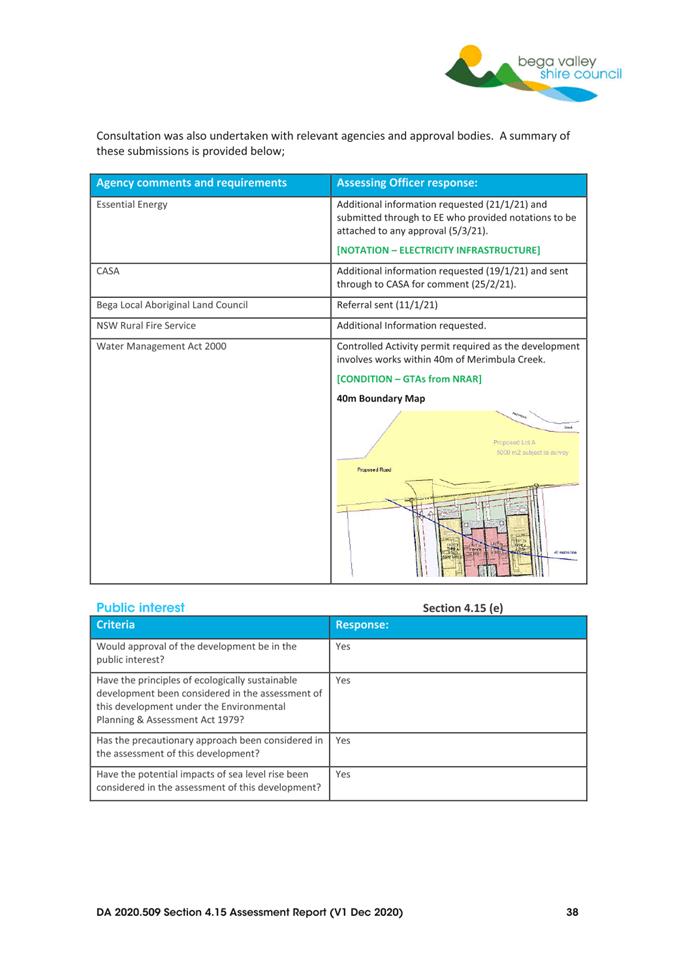
Environment and Climate Change
The design has been adjustment to ensure the APZ is located within the boundaries of the site and does not impact on the riparian land adjacent to Merimbula Creek. Due diligence protocols have been observed in terms of Aboriginal archaeology. A stormwater concept plan was also provided with the proposal.
Economic
The proposed development will contribute to the economy of the Merimbula area.
Risk
The assessment of development is a core function of Council. There is no material impacts on Council’s operations or assets associated with the proposed residential development. A geotechnical report has been prepared and soil and water management measures are required as a condition of consent to ensure the protection of neighbouring properties during any construction works.
Social / Cultural
The proposed residential development would provide for the development of a centrally located site at the edge of the Merimbula town centre. It will contribute towards the activation of the streetscape and the commercial spaces within Merimbula as well as providing housing options in the area.
1⇩. Development Plans
2⇩. Section 4.15 Assessment
3⇩. Recommended Conditions of Consent
4⇩. Applicant's Clause 4.6 Variation Justification
|
Item 8.2 |
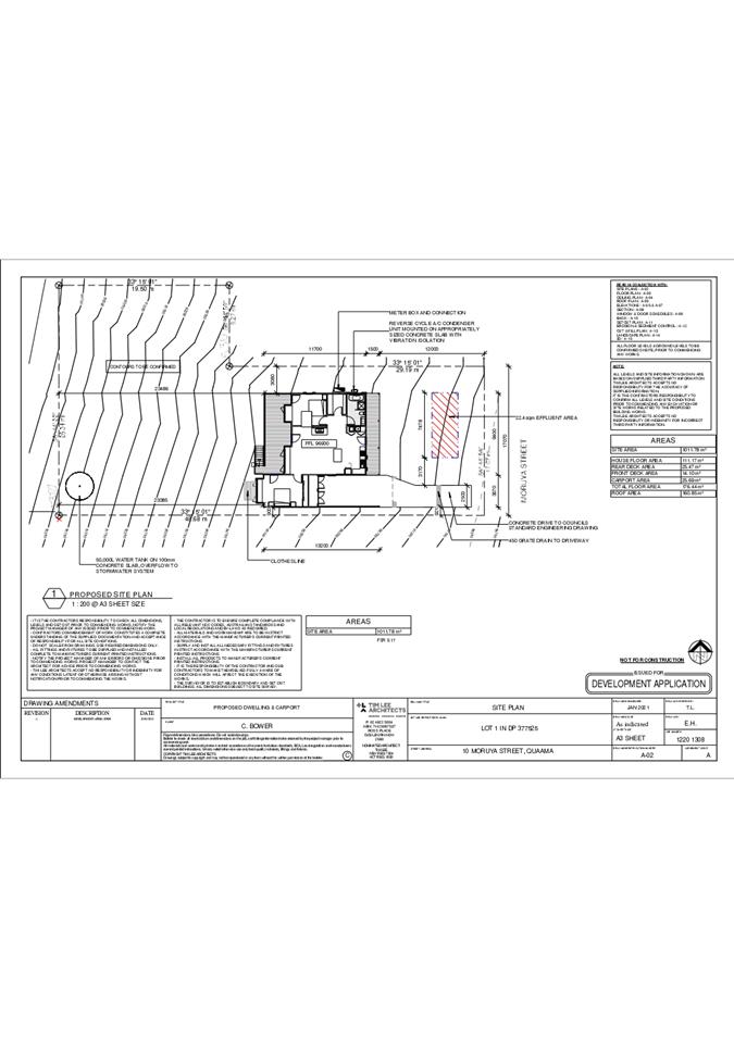
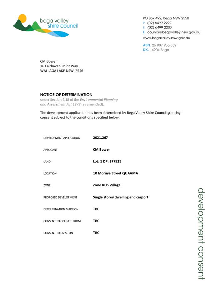
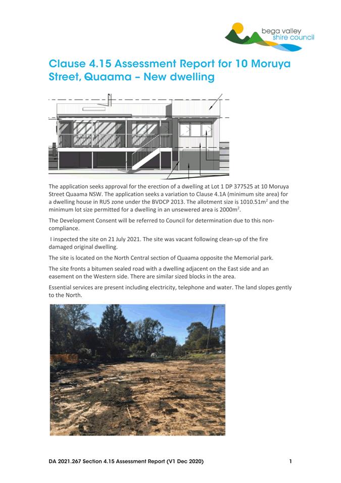
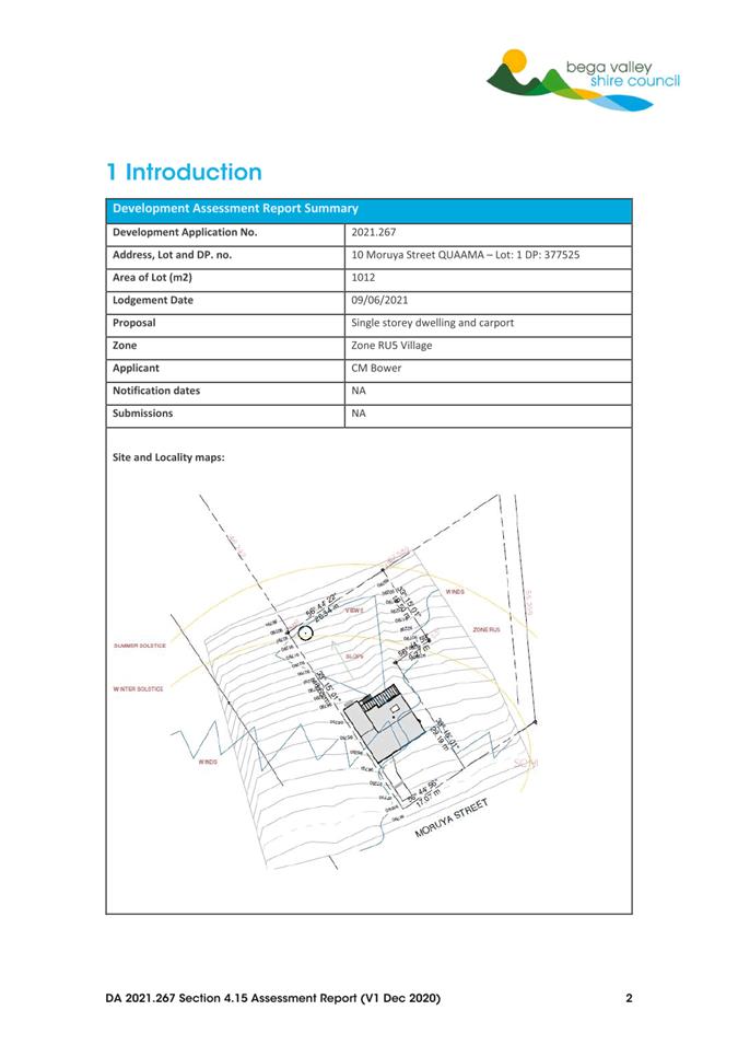
8.2. 2021.267 Dwelling and carport, 10 Moruya Street, Quaama
Director Community Environment and Planning
|
Applicant |
Cecile Bower |
|
Owner |
Nicholas Everingham/ Ashleigh Barnes |
|
Site |
Lot 1 DP 377525 known as 10 Moruya Street, Quaama |
|
Zone |
RU5 |
|
Site area |
1,012m2 |
|
Proposed development |
Dwelling and Carport |
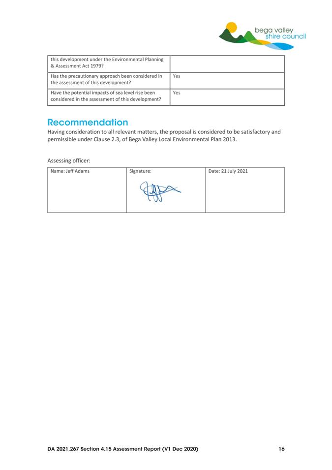
1. That Council assume the concurrence of the Secretary of the Department of Planning, Industry and Environment in accordance with Circular PS 18-003 and pursuant to Clause 4.6 of Bega Valley Local Environmental Plan 2013
2. That Council approve a variation to Clause 4.1A to allow the erection of a dwelling on Lot 1 DP 377525 known as 10 Moruya Street, Quaama.
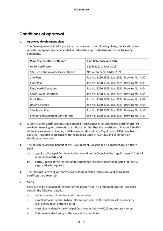
3. That Council approve development application 2021.267 subject to the conditions of consent provided in Attachment 1.
4. That those who made a submission be advised of Council’s decision.
Executive Summary
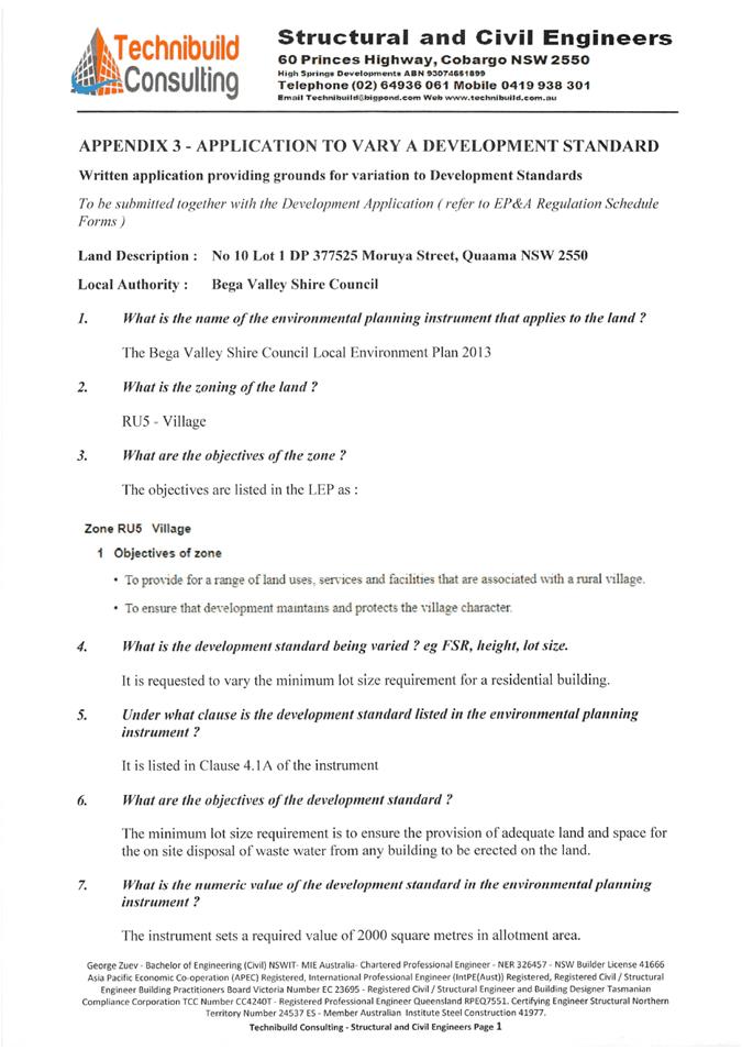
Development application (DA) 2021.267 is being reported to Council as it seeks a variation to a development standard under Clause 4.6 of the Bega Valley Local Environmental Plan 2013 (BVLEP 2013).
Background
Lot 1 DP 377525 known locally as 10 Moruya Street, Quaama, was originally created under Council Clerk’s Certificate No. 1951/8, being a subdivision of the land comprised in Certificate of Title Volume 1111 Folio 134. This subdivision created two unsewered lots: Lot 1 and 2 approximately 1,012m2 and 1,401m2 in size, respectively.
With the gazettal of BVLEP 2013, the requirements for the erection of a dwelling on unsewered residential allotments were amended to require a minimum site area equal to or greater than 2,000m2.
The application seeks variation to the 2,000m2 minimum lot size requirement in order to permit the erection of a new dwelling on the allotment.
Description of the Proposal
The application seeks consent for the erection of a new single storey, two bedroom dwelling with carport. The property is zoned RU5 Village. The allotment is 49.4% below the minimum lot size specified in Clause 4.1A of BVLEP 2013.
The application includes a detailed geotechnical assessment report for the site including justification for the proposed variation to the minimum lot size requirement. The report details the suitability of the site for a dwelling and the capacity for on-site effluent disposal.
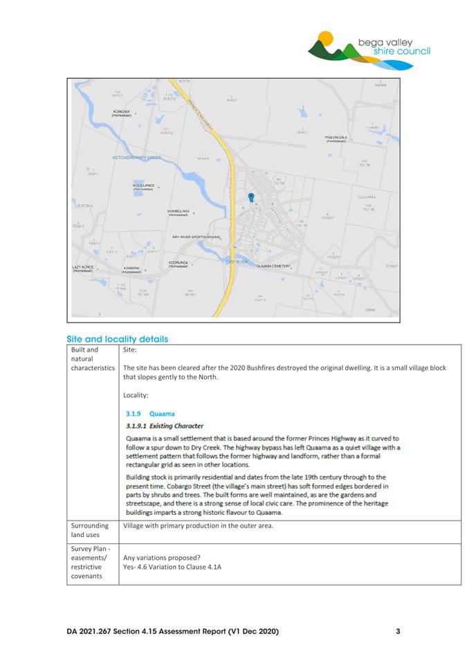
Description of the Site
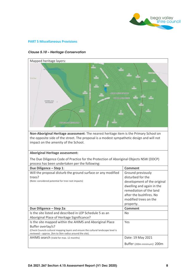
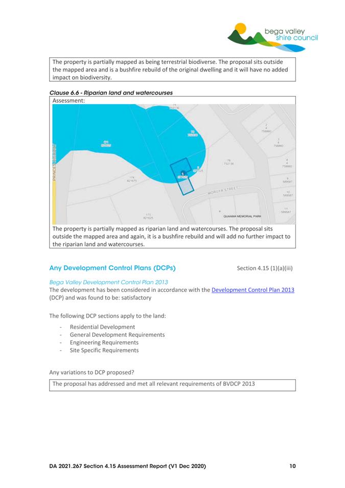
The site is described as Lot 1 DP 377525 known as 10 Moruya Street, Quaama, and has a site area of 1,012m2. It is located approximately 30m from the heritage-listed Quaama Primary School.
The site is ‘L’-shaped and is currently devoid of native vegetation due to post fire clean up works. The site has a neighbouring dwelling to the east and a road easement to the west.
Planning Assessment
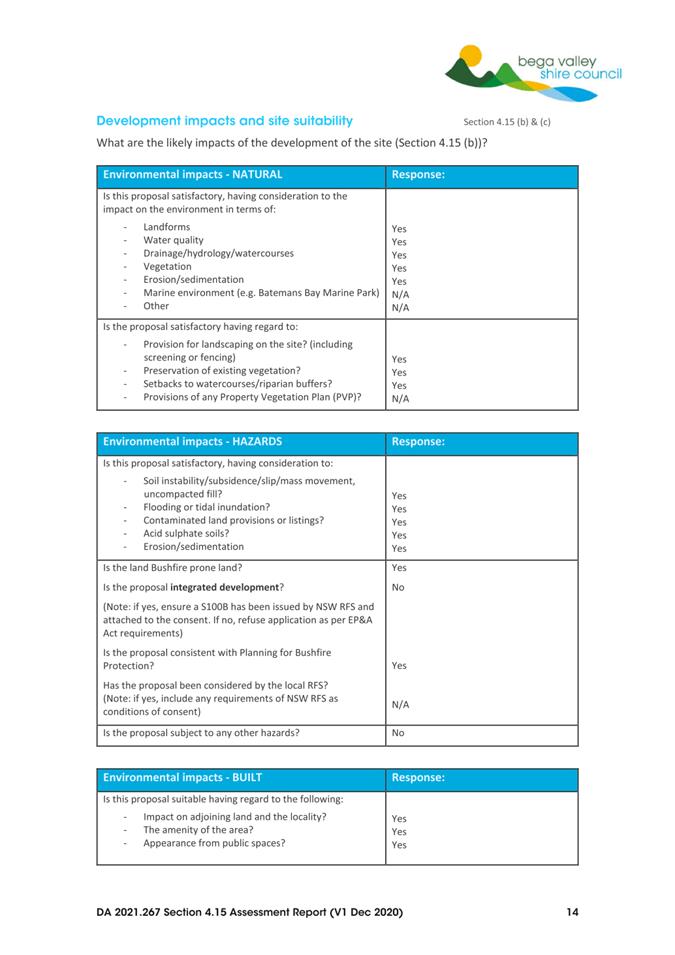
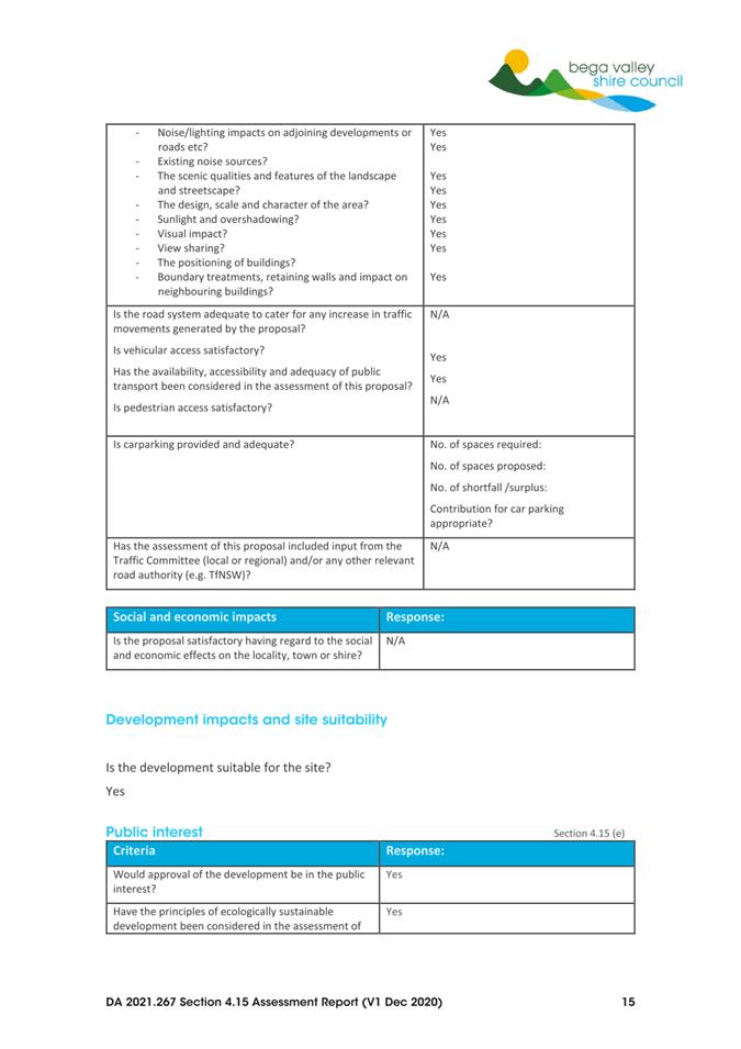
The proposal has been assessed in accordance with the matters for consideration under Section 4.15 of the Environmental Planning and Assessment Act 1979. Council officers have highlighted the key issues of the proposal in this report for Council’s consideration.
Zoning
The land is zoned RU5 Village under the BVLEP 2013, with a dwelling permitted with development consent.
The objectives of the zone are:
• To provide for a range of land uses, services and facilities that are associated with a rural village.
• To ensure that development maintains and protects the village character.
The erection of a dwelling on the allotment is consistent with adjoining residential land use and would complement the existing village character of Quaama.
BVLEP Clause 4.1A ‘Minimum site areas for dwelling houses, dual occupancies, multi-dwelling houses and residential flat buildings in certain zones’
Clause 4.1A of BVLEP 2013 applies to the RU5 Village zone and requires a minimum lot size of 2,000m2 for the erection of a dwelling on unsewered land. As the subject land is zoned RU5, Clause 4.1A applies.
BVLEP Clause 4.6 ‘Exemptions to development standards’
Clause 4.6 of BVLEP 2013 provides for relevant development standards, such as the minimum lot size requirements in Clause 4.1A, to be varied. When considering the use of Clause 4.6 to vary a development standard the following applies:
(1) The objectives of this clause are as follows—
(a) to provide an appropriate degree of flexibility in applying certain development standards to particular development,
(b) to achieve better outcomes for and from development by allowing flexibility in particular circumstances.
(2) Development consent may, subject to this clause, be granted for development even though the development would contravene a development standard imposed by this or any other environmental planning instrument. However, this clause does not apply to a development standard that is expressly excluded from the operation of this clause.
(3) Development consent must not be granted for development that contravenes a development standard unless the consent authority has considered a written request from the applicant that seeks to justify the contravention of the development standard by demonstrating—
(a) that compliance with the development standard is unreasonable or unnecessary in the circumstances of the case, and
(b) that there are sufficient environmental planning grounds to justify contravening the development standard.
(4) Development consent must not be granted for development that contravenes a development standard unless—
(a) the consent authority is satisfied that—
(i) the applicant’s written request has adequately addressed the matters required to be demonstrated by subclause (3), and
(ii) the proposed development will be in the public interest because it is consistent with the objectives of the particular standard and the objectives for development within the zone in which the development is proposed to be carried out, and
(b) the concurrence of the Planning Secretary has been obtained.
In accordance with Planning Circular PS 18-003, Council has assumed the concurrence of the Secretary and can determine this variation to the minimum lot size requirement. As the variation sought is greater than 10%, Council Officers do not have delegation to determine the application under delegated authority and the matter must therefore be reported to Council for determination.
A written request to vary the development standard (Attachment 4) was submitted by the applicant citing the following supporting information:
· The land is located in the village of Quaama.
· The lot was created for the purpose of accommodating a dwelling house.
· The land is serviced with reticulated water and electricity.
· An effluent disposal report has been submitted that demonstrates that the site can accommodate a two-bedroom dwelling housing up to four residents with a total waste output of 600L per day.
Staff response
After reviewing the request for variation, it is considered in this instance, compliance with the minimum lot size development standard of BVLEP 2013 would be unreasonable.
The lot was created for the purpose of accommodating a dwelling house and a dwelling is permissible with consent.
The proposal is consistent with the objective of Clause 4.1A, which is to achieve planned residential density within the RU5 Village zone.
The applicant has adequately addressed the matters of Clause 4.6 (3) and has demonstrated the proposal to be in the public interest, as it is consistent with:
· The objectives of the RU5 Village zone
· The purpose for which the allotment was originally created for, and
· Is in keeping with the existing character and streetscape of Quaama.
Further, the effluent disposal report submitted with the application has been reviewed by Council officers and it is considered that the land is capable of accommodating effluent generated by the proposed development.
Financial and Resource Considerations
Assessing proposals for development is part of the regular business of Council and resourcing to undertake that function is included in Council’s adopted 2021-22 Budget.
Legal /Policy
The variation to the minimum lot size is considered reasonable and justified on planning merit grounds. The development application has been assessed under assumed concurrence.
Impacts on Strategic/Operational/Asset Management Plan/Risk
Strategic Alignment
The proposed plans are consistent with the goals outlined in the Community Strategic Plan 2040, in particular Goals 7 and 8:
· Goal 7: Our Shire continues to be a vibrant, enjoyable, safe and affordable place to live.
· Goal 8: Our places retain their character and scale, development is well planned, and a range of goods and services are available within our Shire that met local needs.
Directions 24 and 45 of the South East and Tablelands Regional Plan 2036:
· Direction 24: Deliver greater housing supply and choice.
· Direction 25: Focus housing growth in locations that maximise infrastructure and services.
The proposed development is consistent with Council’s adopted Residential Land Strategy and LSPS.
Environment and Climate Change
The proposed development does not present material environment or climate change impacts. On site disposal of effluent is able to be managed and the site has low habitat value.
Economic
The proposed development will have a marginal positive benefit to the local economy.
Risk
The assessment of development is a core function of Council. There is no material impacts on Council’s operations or assets associated with the proposed residential development. A geotechnical report has been prepared and effluent management measures are required as a condition of consent.
Social / Cultural
The proposed residential development directly supports bushfire recovery for the landowner, and contributes to the rebuilding of Quaama village.
Attachments
1⇩. Site Plan
2⇩. 2021.267 Recommended Conditions of Consent
3⇩. 2021.267 4.15 Assessment
4⇩. 2021.267 4.6 Variation Application
|
Item 8.3 |
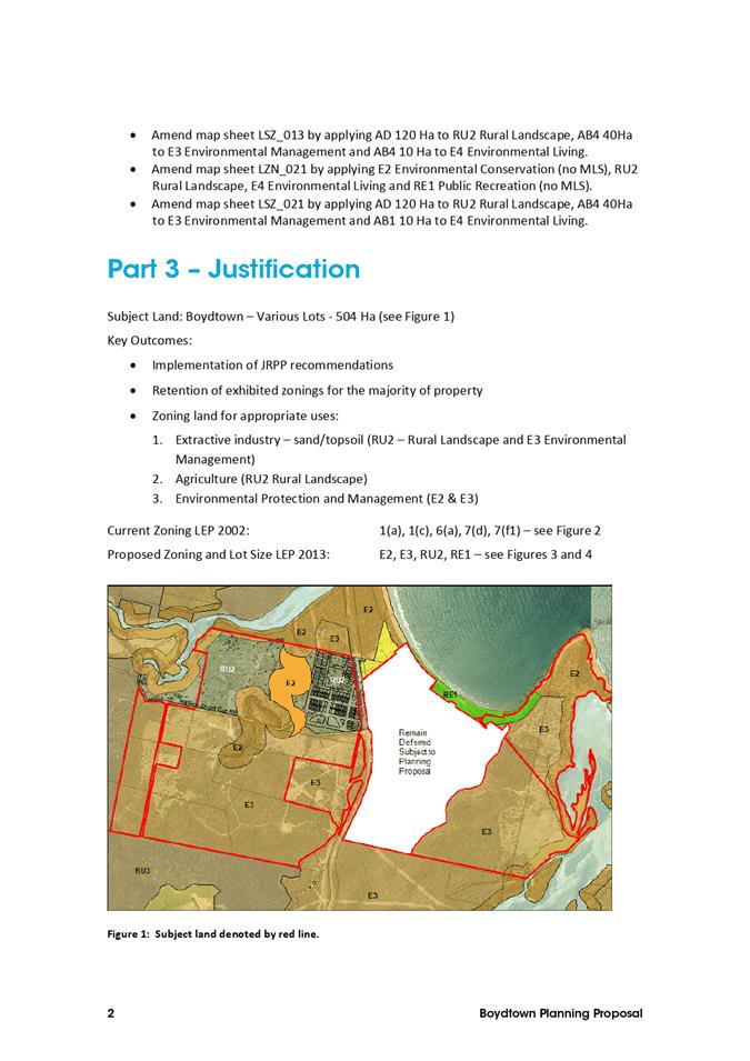
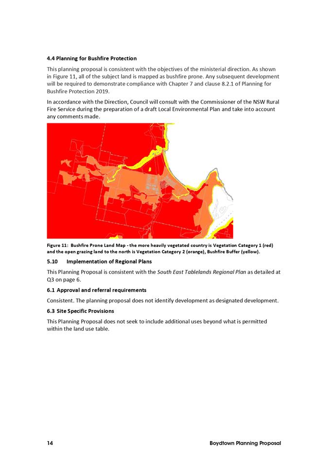
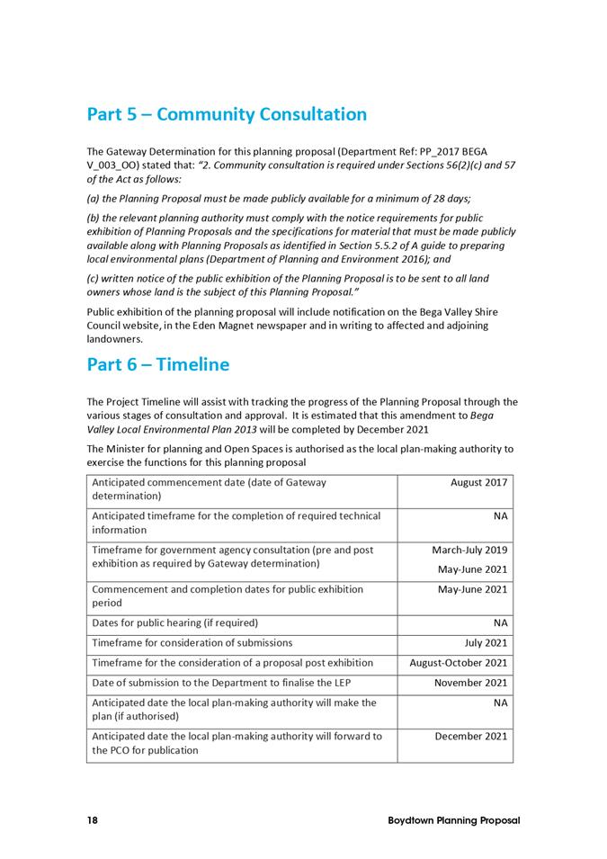
8.3. Finalisation of planning proposal for certain land at Boydtown
The planning proposal to amend the Bega Valley Local Environmental Plan 2013 to zone and apply minimum lot size standards for certain land at Boydtown has been publicly exhibited. This report seeks Council’s resolution to progress the planning proposal.
Director Community Environment and Planning
That Council:
1. Support the amendment to Bega Valley Local Environmental Plan 2013 (Amendment 38) for certain land at Boydtown as exhibited (Attachment 1) and request that the Minister of Planning and Public Spaces make the plan.
2. Advise those who made a submission during exhibition of the planning proposal of Council’s resolution on this matter.
Executive Summary
Public exhibition of the planning proposal to amend Bega Valley Local Environmental Plan 2013 (BVLEP 2013) to zone and apply minimum lot size standards for certain land at Boydtown took place between 27 May and 4 July 2021. One public and three NSW Government agency submissions were received on the planning proposal. Following a review of the feedback received, no changes to the planning proposal as exhibited are recommended.
A report to consider the matter was initially presented the 4 August 2021 Council meeting however the item was deferred to try and accommodate a face to face presentation to Council by the owners of the land the matter relates to.
The purpose of this report is to advise Council of the feedback received during exhibition of the planning proposal and seek a resolution to progress the matter. In accordance with the Gateway Determination, Council does not have delegation to finalise the planning proposal, instead the Minister for Planning and Public Spaces is authorised as the local plan-making authority.
Background
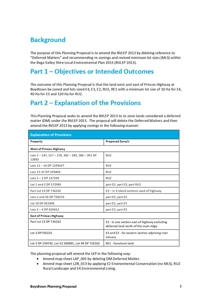
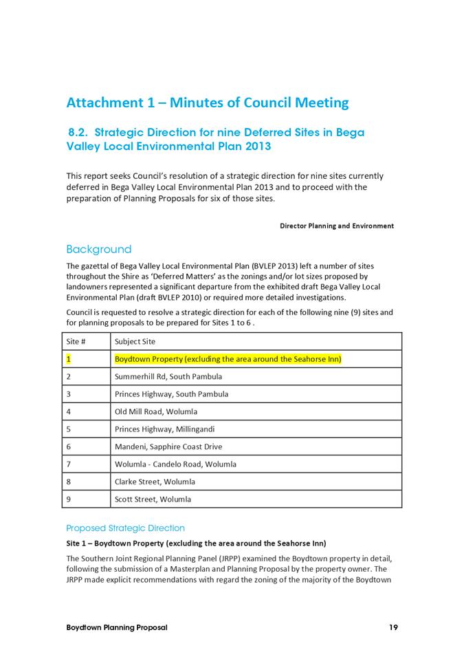
At the meeting of 20 July 2016, Council considered a report on several sites that were deferred from BVLEP 2013. With regard to Boydtown, Council resolved the following:
a) Site 1 – Boydtown Property (excluding the area around the Seahorse Inn)
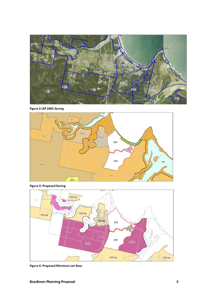
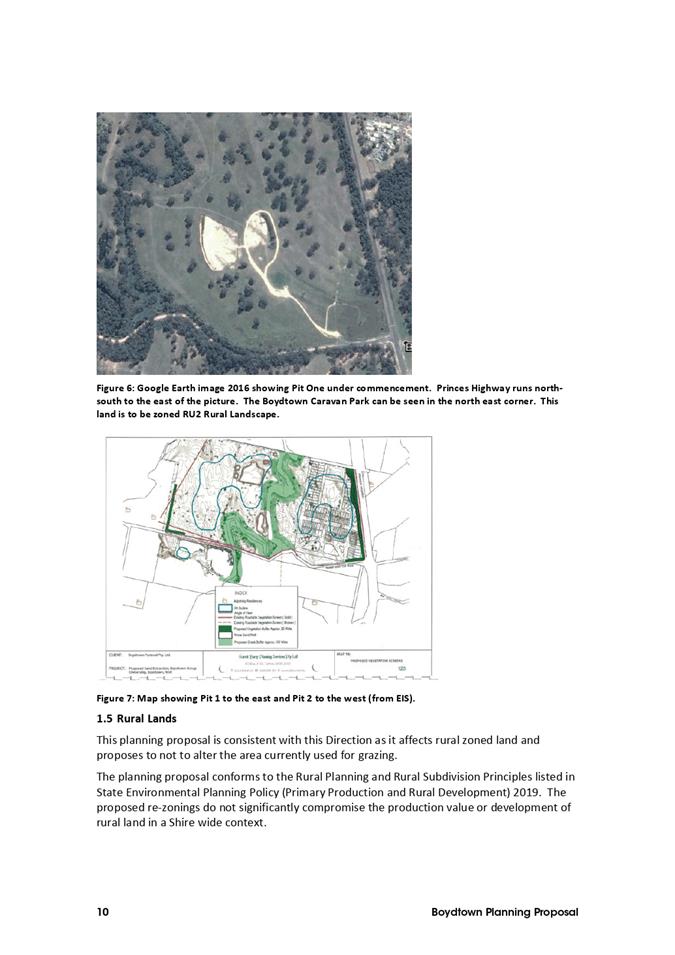
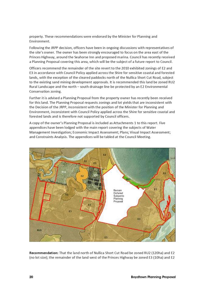
That the land north of Nullica Short Cut Rd be zoned RU2 (120ha) and E2 (no lot size); the remainder of the land west of the Princes Hwy be zoned E3 (10ha) and E2 (no lot size); and the south eastern section of the property adjoining the Towamba River estuary be zoned E3 (40ha) and E2 (no lot size).
This resolution was based on the recommendation of the Southern Joint Regional Planning Panel (JRPP), which examined the Boydtown property in detail following the submission of a Masterplan and planning proposal by the property owner. The JRPP made explicit recommendations with regard to the zoning of most of the Boydtown property. These recommendations were endorsed by the [then] Minister for Planning and Environment and included that the land that is the subject of this planning proposal be:
“zoned in accordance with draft Bega Valley LEP 2010 as exhibited as E2 Environmental Conservation and E3 Environmental Management with applicable development standards, other than land occupied by the approved extractive industry along Nullica Short Cut Road which is to be zoned RU2 Landscape and E2 Environmental Conservation.”
The Gateway Determination was issued in August 2017 and extended at the request of Council in March 2019. Council staff commenced implementation of the Gateway Determination, but the planning proposal was not finalised as the owner has been preparing a separate planning proposal for the whole site.
A further request for extension of time for the planning proposal was refused in January 2021. Part of the reason for refusal was to ensure consistency with advice provided by the NSW Department of Planning, Industry and Environment (DPIE) to all NSW councils to streamline and simplify the planning system, including accelerating planning proposals. Following that correspondence, Council received further notification from the Coordinator General of DPIE’s Planning Delivery Unit that plans needed to be put in place to ensure this outstanding planning proposal is completed before the end of 2021.
Options
Council can proceed to request that the matter is finalised by the Minister for Planning and Public Spaces. This would ensure that part of the Boydtown area is undeferred from BVLEP 2013 and the standards of BVLEP 2013 would apply to the land. This is the preferred option.
Council could choose to withdraw the planning proposal and the land would remain deferred from BVLEP 2013. Undeferring the land would then require a new planning proposal to be prepared, either by the landowner or by Council, and submitted to the Gateway so the process could begin again. This option would require the investment of significant resources by Council.
It is noted that under DPIE’s A Guide to Preparing Local Environmental Plans, progressing the current planning proposal will not preclude the owner of the land from lodging a new planning proposal over the land for Council’s consideration at a later date.
Community and Stakeholder Engagement
Engagement undertaken
Consultation was conducted in accordance with the requirements of the Gateway Determination and Council’s adopted Community Engagement Strategy. Public exhibition was undertaken for 39 days from 27 May until 4 July 2021. Exhibition of the planning proposal was notified on the ‘Have Your Say’ page of Council’s website, a public notice was placed in the Eden Magnet newspaper, and the owner of the land was notified directly by post and by email to their planning consultant.
In accordance with the Gateway Determination, consultation with the NSW Department of Planning, Industry rand Environment Biodiversity Conservation Division (BCD), NSW Department of Primary Industries – Agriculture (DPI Agriculture) and NSW Rural Fire Service (RFS) was also undertaken.
Summary of submissions
One public and three agency submissions were received during the exhibition.
The key issues raised in the submissions are outlined below, including responses by Council staff.
1) NSW Department of Primary Industries - Agriculture
Issue summary: DPI Agriculture did not object to the proposal to rezone Boydtown lands west of the Princes Highway as the land being used for extensive agriculture and extractive industry will be zoned RU2 Rural Landscape enabling these uses to remain permissible.
Staff response: Noted
Recommendation: No change to planning proposal
2) NSW Rural Fire Service
Issue summary: The RFS raised no objections to the proposal subject to a requirement that future development complies with Planning for Bush Fire Protection 2019.
Staff response: Noted. Compliance with Planning for Bush Fire Protection 2019 is part of the normal development assessment process for any development application on bushfire prone mapped land.
Recommendation: No change to planning proposal
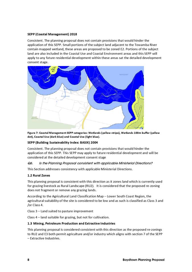
3) DPIE Biodiversity Conservation Division
Issue summary: BCD did not object to the planning proposal and supported the application of the E2 Environmental Conservation and E3 Environment Management zones. However, the agency did raise concerns regarding the minimum lot size of 10ha for the E3 zoned land on the western side of the highway as they prefer a minimum lot size of 40ha for any E3 zoned land.
Staff response: It is acknowledged that 10ha is an unusual lot size for E3 zoned land in the Bega Valley Shire and that the E4 Environmental Living zone would better reflect Council’s objectives for future development of the land for rural residential purposes and the strategic direction for the E3 and E4 the zones in the Bega Valley Shire.
Recommendation: It is recommended that Council advise DPIE that it would support the application of the E4 Environmental Living zone over the part of the land that is proposed to have a 10ha minimum lot size; however, no change to the current E3 zone is proposed at this stage.
4) Submission on behalf of owner
Issue summary: The zoning and minimum lot sizes in the planning proposal are inappropriate, unjustified, based on inaccurate or old information and will sterilize future development opportunity on the site. The public exhibition of the proposed zoning demonstrates that Council have actively misled the proponent, resulting in substantial financial cost and losses. Council has not complied with the conditions of the Gateway Determination. Request that Council withdraw the existing planning proposal with a view to progressing the current Lyon Group planning proposal which has been developed over the last four years.
Staff response:
The zoning and minimum lot sizes in the planning proposal are in accordance with the recommendations of the JRPP as endorsed by the [then] Minister for Planning and Environment. The public exhibition of the proposed zoning is the result of Council fulfilling the requirements of the Gateway Determination for the site and in line with NSW Government directives.
Council complied with the conditions of the Gateway Determination regarding updating the planning proposal, confirming the criteria for applying an environmental zone and consultation with the [then] Office of Environment and Heritage and the [then] Department of Planning. Copies of relevant correspondence was provided to the applicant prior to the exhibition and the exhibited planning proposal was endorsed by DPIE.
Council staff have been working with the owner of the land to develop a zoning scheme and planning controls for Boydtown since 2004. Over the past few years, the owner of the site has been preparing a separate planning proposal for the whole Boydtown site, which includes the land that is the subject of this planning proposal. Although the owner has made significant progress towards a planning proposal that Council could endorse, including the lodgement of a new planning proposal in July 2021, the is no timeframe for completion at this stage.
Given the current situation with the planning proposal for the whole site, the significant Council resources that have been involved to date, the current requirements of NSW Government agencies regarding planning proposals and the directions of the Planning Delivery Unit to finalise a planning proposal for part of the site, it is considered prudent for Council to proceed to complete the 2017 planning proposal.
It is noted that Council staff are continuing to work with representatives of the owner to finalise a zoning scheme and development standards for the whole site to maximise opportunities to implement Council’s current strategic objectives for residential and rural residential land use. Council has confirmed with NSW Government agencies that finalisation of this planning proposal will not prevent a future planning proposal being lodged to amend the zoning or lot size standards that are applied through this process.
Recommendation: It is recommended that Council proceed with the planning proposal to implement a zoning scheme under BVLEP 2013 for the subject area, and that any subsequent planning proposals submitted for the land be assessed based on Council’s adopted strategic land use objectives and in accordance with applicable legislation and DPIE guidelines.
Financial and Resource Considerations
The public exhibition of the planning proposal was undertaken as part of Council’s regular work program and within the adopted 2020-21 budget.
|
Item |
$ Excl GST |
|
Expenditure Detail |
|
|
Advertising |
$600 |
|
Total Expenditure |
$600 |
|
Source of Funds |
|
|
General Fund |
$600 |
|
Total income available |
$600 |
|
Project Funding Shortfall |
Nil |
Legal /Policy
The planning proposal has been prepared in accordance with Section 3.33 of the Environmental Planning and Assessment Act 1979 and the NSW Department of Planning, Industry and Environment’s A Guide to Preparing Planning Proposals (December 2018).
Impacts on Strategic/Operational/Asset Management Plan/Risk
Strategic Alignment
The planning proposal aims to achieve the following directions of DPIE’s South East and Tablelands Regional Plan 2036:
· Direction 14: Protect important environmental assets
· Direction 13: Manage the ongoing use of mineral resources.
The planning proposal is consistent with the following goals of the Bega Valley Shire Community Strategic Plan 2040:
· Goal 5: Our air and water is pristine and our natural environment and rural landscapes are protected as future development in rural areas resulting from the planning proposal will be appropriate
· Goal 8: Our places retain their character and scale, development is well planned, and a range of goods and services are available with our Shire that meet local needs as future development resulting from this planning proposal will be in keeping with the existing character and scale of existing development in rural areas
The planning proposal is consistent with the following directions of the Bega Valley Shire Local Strategic Planning Statement 2040:
· Continue to protect major estuary foreshores and sensitive water catchments to maintain and improve water quality.
· Protect catchments of sensitive receiving waters including water supply storages and priority estuaries used for aquaculture, tourism and recreation.
Environment and Climate Change
It is unlikely that this planning proposal will have an adverse impact on environmental values or increase risk to life or assets from climate change because the planning proposal does not provide a significant increase in the development potential on the land and seeks to zone environmentally sensitive land appropriately.
Economic
It is unlikely that this planning proposal will have any significant economic impacts because the planning proposal does not provide for a significant increase in the development potential on the land and no provision of public infrastructure is required by Council to implement the planning proposal.
Risk
The planning proposal will not significantly increase risk to life from new dwellings or increase the risk of land use conflict with existing primary industry operations because the planning proposal does not provide a significant increase in the development potential on the land.
Social / Cultural
The extent of any social or cultural impacts resulting from the planning proposal is expected to be limited due to the relatively small number of lots that will result from the planning proposal.
Attachments
1⇩. Exhibited Boydtown Planning Proposal
Council |
18 August 2021 |
10.1 Submission on Snowy Mountains Special Activation Precinct Draft Master Plan 210
|
Council 18 August 2021 |
Item 10.1 |
10.1. Submission on Snowy Mountains Special Activation Precinct Draft Master Plan
This report recommends that Council make a submission on the Snowy Mountains Special Activation Precinct Draft Master Plan.
Director Community Environment and Planning
That Council make a submission (Attachment 1) to the NSW Department of Planning, Industry and Environment providing feedback on the Snowy Mountains Special Activation Precinct Draft Master Plan.
Executive Summary
The NSW Department of Planning, Industry and Environment (DPIE) has recently released the Snowy Mountains Special Activation Precinct Draft Master Plan and Discussion Paper. These documents identify land included in the Special Activation Precinct (SAP) and how existing planning instruments will be amended to deliver jobs and economic development for the Snowy Mountains over the next 40 years.
This report identifies some of the implication of the SAP for the Bega Valley Shire and proposes that Council make a submission on the draft Master Plan.
Background
The NSW Deputy Premier announced the development of a SAP for the Snowy Mountains in November 2019. At the time, the Deputy Premier advised that work to investigate the SAP would also look at opportunities to improve regional linkages to other tourism destinations including Eden. The SAP draft Master Plan has now been released for public comment, with submissions closing on 23 August 2021. Documents are available at Snowy Mountains Special Activation Precinct (nsw.gov.au). Neither the Bega Valley Shire nor Eden are specifically mentioned.
The SAP (Figure 1) involves five key components: streamlined planning to reduce costs and time for business development, Government-led studies to support streamlined planning, Government-led infrastructure development, through Regional Growth NSW’s Development Corporation; infrastructure investment in roads, utilities and social infrastructure; and a business concierge service through the Regional Growth NSW Development Corporation.
The SAP will be delivered through amendment of State Environmental Planning Policy (Activation Precincts) 2020, the Alpine State Environmental Planning Policy and the Kosciusko National Park Plan of Management.
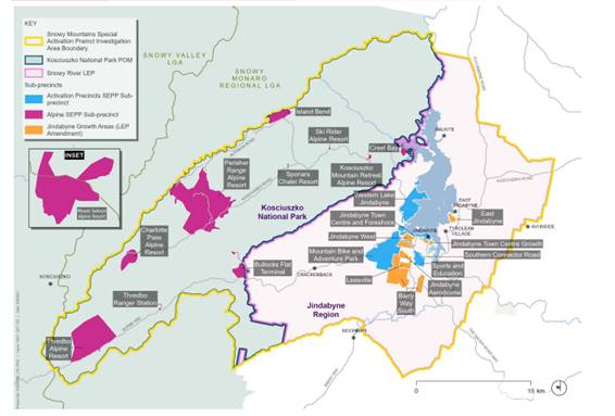
Figure 1 – Land included in the Snowy Mountains Special Activation Precinct - DPIE 2021
Options
Options available to Council are to make a submission (this is the recommended option – either by submitting Attachment 1 or advising of amendments to it prior to submission) or not make a submission.
Community and Stakeholder Engagement
Engagement undertaken
Council engaged in advocacy in 2019, which led to the inclusion of Eden in the scope of the SAP investigation. Council officers and the NSW Port Authority met with the SAP project team in December 2019 to discuss data required to inform assessment of the Eden element of the SAP investigation. On this basis, reference to inclusion of the Port of Eden in the Snowy Mountains Special Activation Precinct was included in Council’s Local Strategic Planning Statement, which was adopted by Council in June 2020 and subsequently endorsed by DPIE. No further engagement with the NSW Government has occurred since then.
Engagement planned
It is proposed that Council engage with DPIE on the draft Master Plan by making a submission, and that the submission also be provided to the local State and Federal Members of Parliament.
Financial and Resource Considerations
There are no material financial or resource considerations associated with making a submission, as this is undertaken with in house resources allocated to such work.
There are significant financial and resource implications for Bega Valley Shire associated with the SAP. These include availability of labour and housing, cost and availability of materials, changes to visitation and local infrastructure investment.
Legal /Policy
There are no material legal or policy implications of making a submission.
The area of the SAP does not include Eden, and therefore there are no proposed changes to planning instruments that are likely to apply to Bega Valley Shire.
Impacts on Strategic/Operational/Asset Management Plan/Risk
Strategic Alignment
There are no material strategic impacts associated with Council making a submission on the Snowy Mountains SAP.
The adopted Bega Valley Local Strategic Planning Statement 2040 references that the Snowy Mountains Special Activation Precinct was to include the Port of Eden.
Environment and Climate Change
There are no material environment and climate change impacts associated with Council making a submission on the Snowy Mountains SAP, and the draft Master Plan does not directly affect the environment of Bega Valley Shire.
The draft Master Plan addresses environmental impacts associated with the proposed SAP. The SAP aims to support delivery of Snowy Hydro 2.0, which will materially assist to reduce the carbon intensity of the National Electricity Market.
Economic
There are no material economic impacts associated with Council making a submission on the Snowy Mountains SAP.
As the Snowy Mountains SAP does not include the Port of Eden, Bega Valley Shire will not directly benefit from the support identified in the Discussion Paper. There are, however, likely to be material impacts on the Bega Valley Shire, and other surrounding local government areas (LGAs), from the activity proposed for the Snowy Mountains SAP. While impacts on neighbouring LGAs are not assessed in the Discussion Paper, they may include:
· Adverse impacts on the supply of labour
· Adverse impacts on the affordability and availability of materials
· Adverse impacts for housing affordability and a availability
· Favourable impacts for the visitor economy
Risk
There are no material new risks for Council in making a submission, as proposed.
Social / Cultural
There are no material social or cultural impacts associated with Council making a submission, and the draft Master Plan does not directly affect the community of Bega Valley Shire.
The Snowy Mountains SAP includes provision of community infrastructure for the area shown in Figure 1, such as expansion of walking and cycling trails, sporting and recreation infrastructure and nature-based tourism facilities. These facilities are likely to compliment facilities available in the Bega Valley and may be utilised by Bega Valley Shire residents from time to time.
Attachments
1⇩. Proposed Submission - Snowy Mountains Special Activation Precinct
|
18 August 2021 |
|
|
Item 10.1 - Attachment 1 |
Proposed Submission - Snowy Mountains Special Activation Precinct |
Council |
18 August 2021 |
11.1 Notice to the Minister for Lands and Forestry of Council's employed Native Title Managers........................................................................................................................... 218
11.2 Eden Skatepark and Connecting Areas - Concept Designs............................... 226
|
Council 18 August 2021 |
Item 11.1 |
11.1. Notice to the Minister for Lands and Forestry of Council's employed Native Title Managers
A resolution of Council is required to give notice to the Minister for Lands and Forestry of the name and contact details of Council’s engaged or employed Native Title Managers.
Director Assets and Operations
1. That Council receive and note the report.
2. That Council give notice to the Minister for Lands and Forestry of the name and contact details of Council’s engaged or employed Native Title Managers, as required, under Section 8.8 of the Crown Land Management Act 2016 (NSW).
Executive Summary
Council is required to give notice to the Minister for Lands and Forestry of the name and contact details of Council’s engaged or employed Native Title Managers by 31 October each year.
Section 377(1)(s) of the Local Government Act 1993 (NSW) (LG Act) states that the making of an application, or the giving of a notice, to the Governor or Minister is a non-delegable function meaning a Resolution of Council is required for such purposes.
Background
The practice of managing Crown Land in the Shire has changed significantly as a result of the Crown Land Management Act 2016 (NSW) (CLM Act) which came into force on 1 July 2018. To comply with the requirements of the CLM Act, Council is required to engage or employ at least one qualified Native Title Manager. Pursuant to Section 8.7 of the CLM Act written advice from a Native Title Manager must be obtained for any dealing by Council on Crown Land to ensure those dealings can be validated under Native Title legislation.
A Native Title Manager is a person who has undertaken the approved training facilitated jointly by the Crown Solicitors Office and the Department of Industry – Lands and Water and holds the necessary qualification issued by Department of Industry – Lands and Water. Council officers Rickee Marshall and Rob Quick attended this training on 17 November 2017 and Matthew Collins attended the training on 31 May 2018. These staff have therefore attained the Native Title Manager qualification for the purposes of the CLM Act.
Options
There are no options for Council to consider in relation to the report as Council is required to give notice to the Minister for Lands and Forestry of the name and contact details of Council’s engaged or employed Native Title Managers each year under section 8.8 of the CLM Act.
Community and Stakeholder Engagement
Engagement undertaken
From time to time Council engages the services of Craig Barnes from Landsas to assist in navigating the complexities of dealing with land where native title applies.
Craig Barnes is a native title manager under the CLM Act and assists Council on the following:
• assesses whether native title has been extinguished over land Council owns or manages;
• provides advice as a native title manager and legal advice in relation to native title; and
• determines the appropriate future act to allow an activity to be validly undertaken on land subject to native title.
Engagement planned
Once a Council resolution has been passed Council officers will advise Crown Lands of the nominated Native Title Managers, as required each year under section 8.8 of the CLM Act by no later than 31 October 2021.
Financial and Resource Considerations
No financial implications relating to this responsibility have been identified at this stage. It should be noted that all three staff currently have full time roles within Council and the designation of Native Title Manager is a role in addition to their current workload. The impacts of work required under the CLM Act will continue to be monitored as roll out of the implementation of the Act continues.
Legal /Policy
Council must employ or engage at least one Native Title Manager to ensure dealings with land comply with any applicable provisions of the Native Title legislation. Section 8.8 of the CLM Act requires each Council to give notice to the Minister for Lands and Forestry of the name and contact details of any person the Council has engaged or employed as a Native Title Manager. The notice must be given by 31 October of each year.
Section 377(1) of the LG Act states that the giving of a notice to the Governor or Minister is a non-delegable function meaning a Resolution of Council is required.
Impacts on Strategic/Operational/Asset Management Plan/Risk
Strategic Alignment
Providing notice to the Minister for Lands and Forestry of the name and contact details of Council’s engaged or employed Native Title Managers, as required, under section 8.8 of the CLM Act algins with the requirements under Council’s Delivery Program 2017-2022 and Operational Plan 2021-2022 to manage Council’s property portfolio and meet statutory obligations.
Environment and Climate Change
There are no environment and climate change matters associated with the report.
Economic
There are no economic matters associated with the report.
Risk
Council will not be complying with the provisions of the CLM Act if it does not formally nominate its engaged or employed Native Title Managers to the Minister for Lands and Forestry prior to 31 October each year.
Social / Cultural
There are no social/cultural matters associated with the report.
Attachments
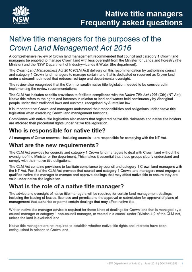
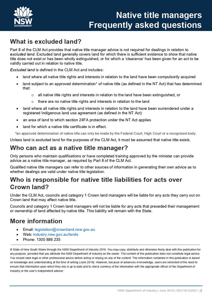
1⇩. Native Title Manager FAQ
2⇩. Native Title Manager Qualification - Rickee Marshall
3⇩. Native Title Manager Qualification - Robert Quick
4⇩. Native Title Manager Qualification - Matthew Collins
|
18 August 2021 |
|
|
Item 11.1 - Attachment 2 |
Native Title Manager Qualification - Rickee Marshall |
|
Council |
18 August 2021 |
|
Item 11.1 - Attachment 4 |
Native Title Manager Qualification - Matthew Collins |
|
Council 18 August 2021 |
Item 11.2 |
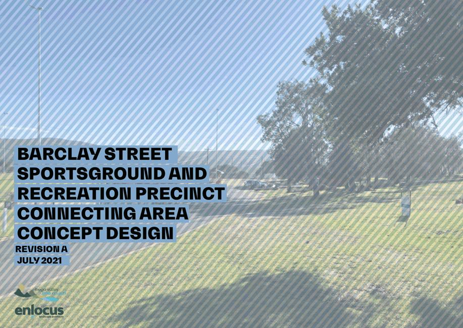
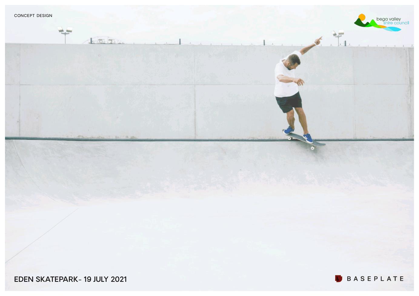
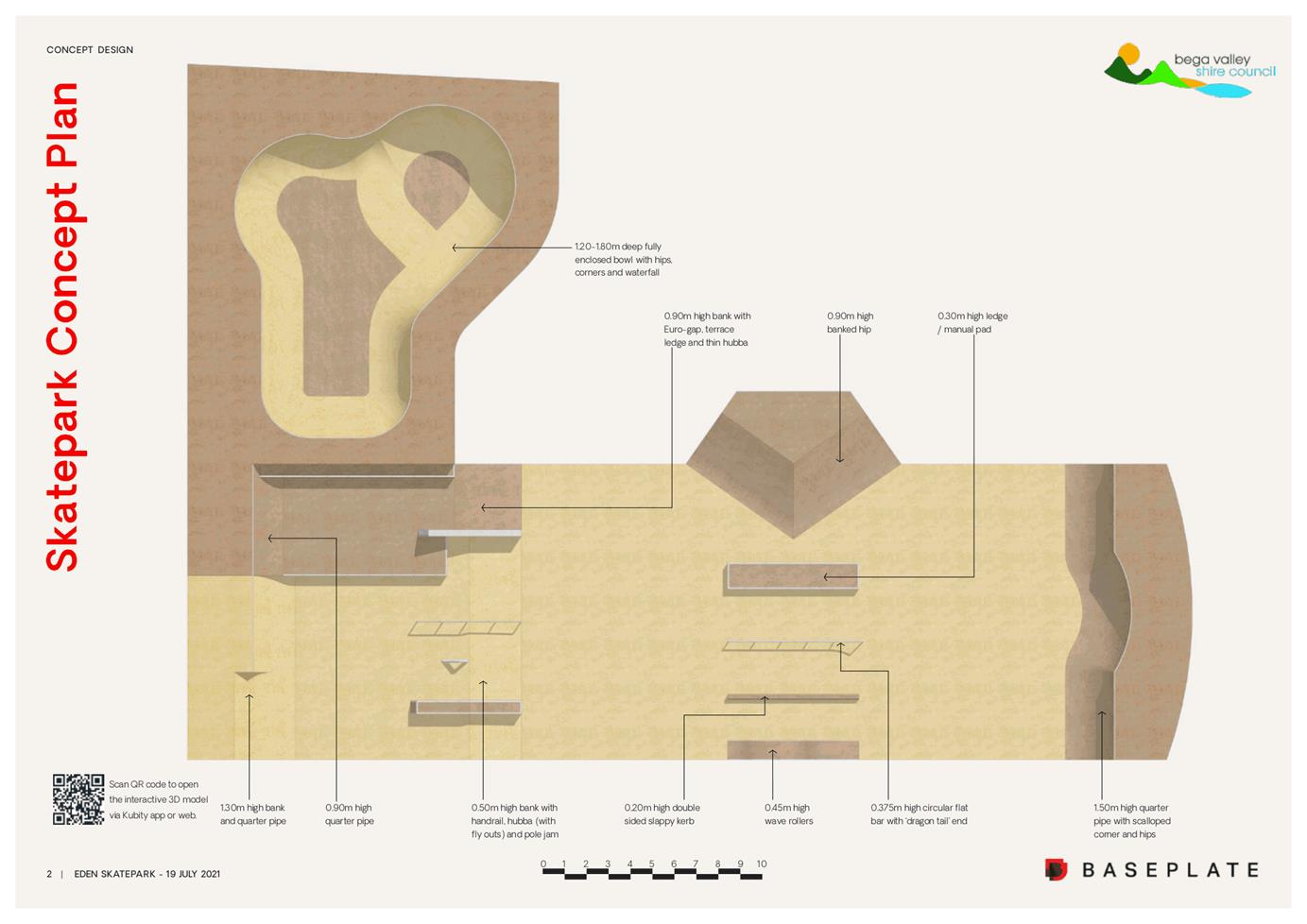
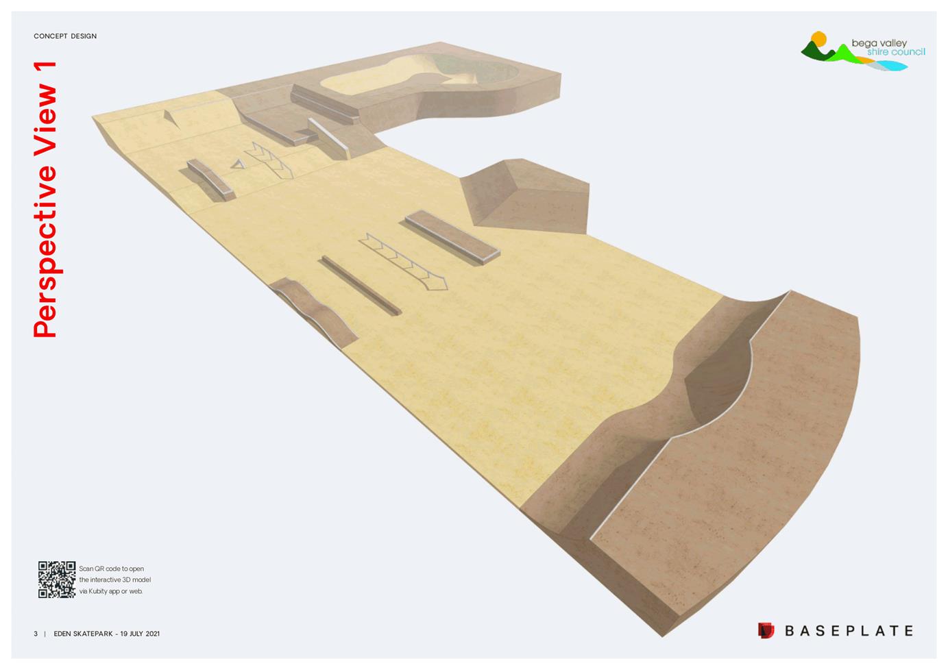
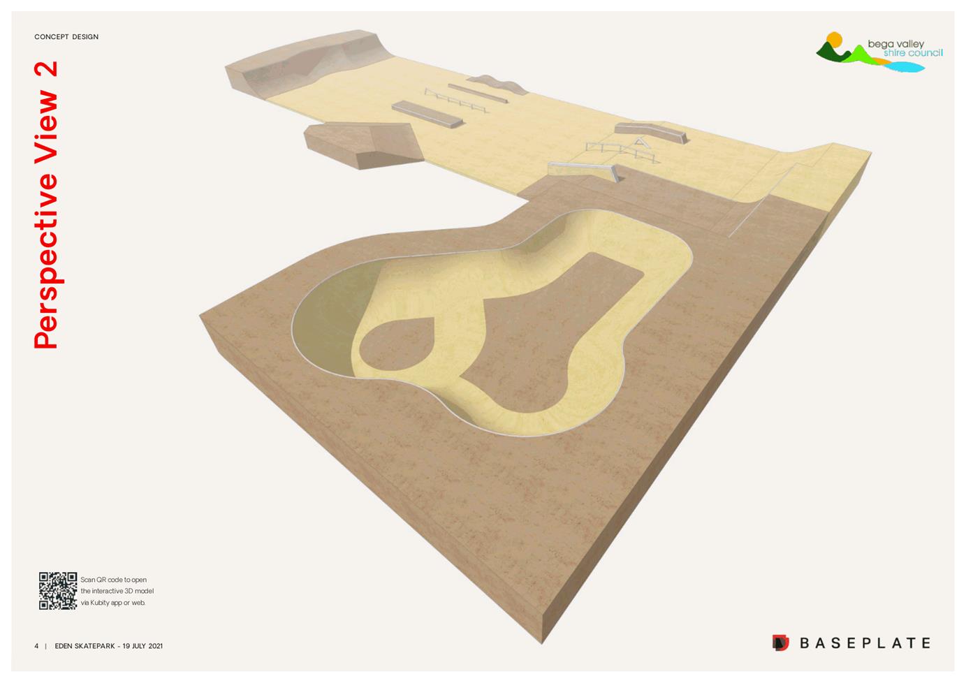
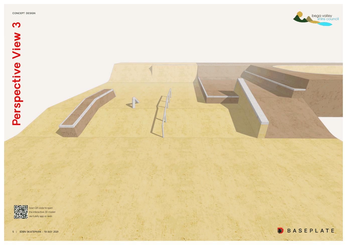
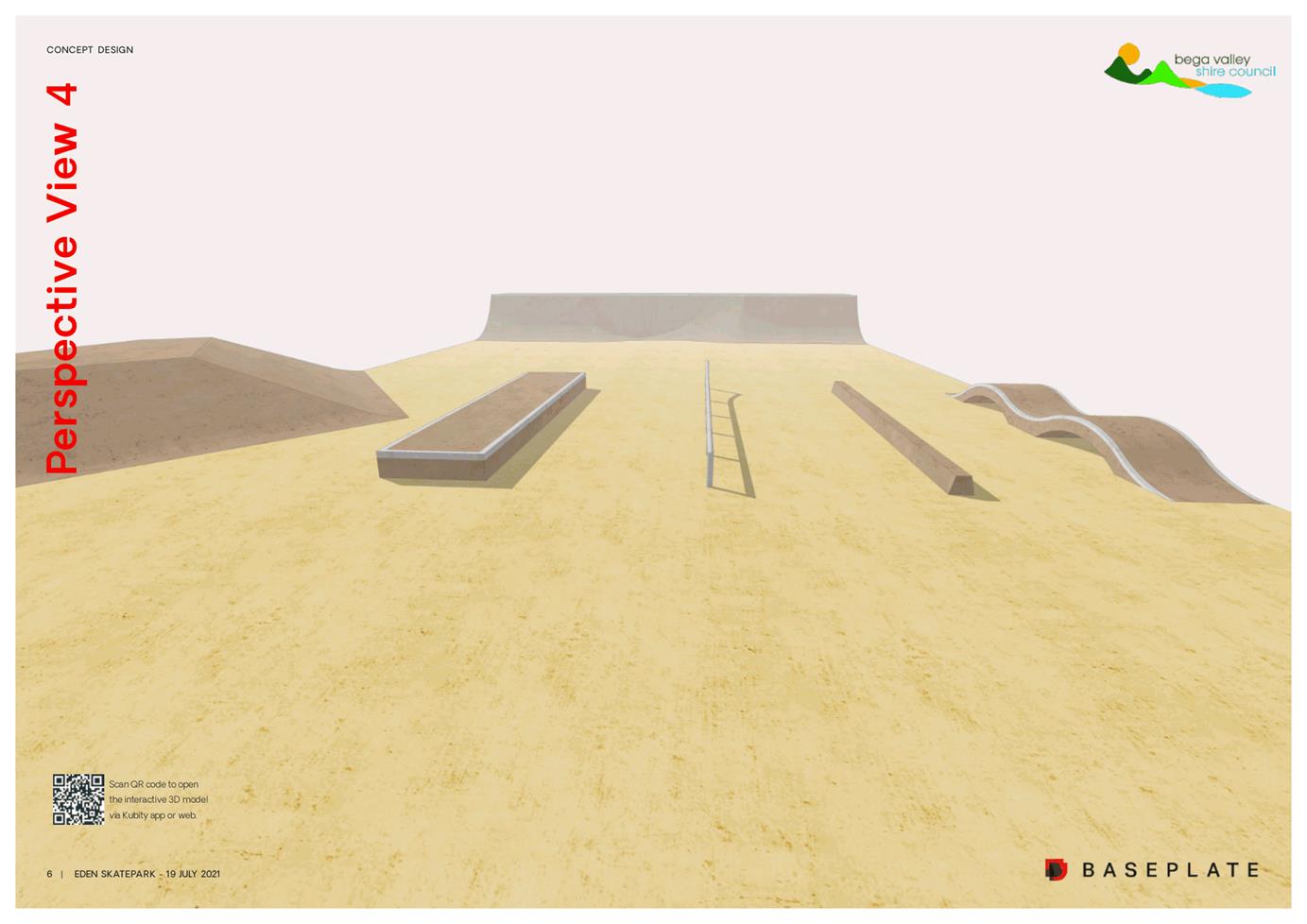
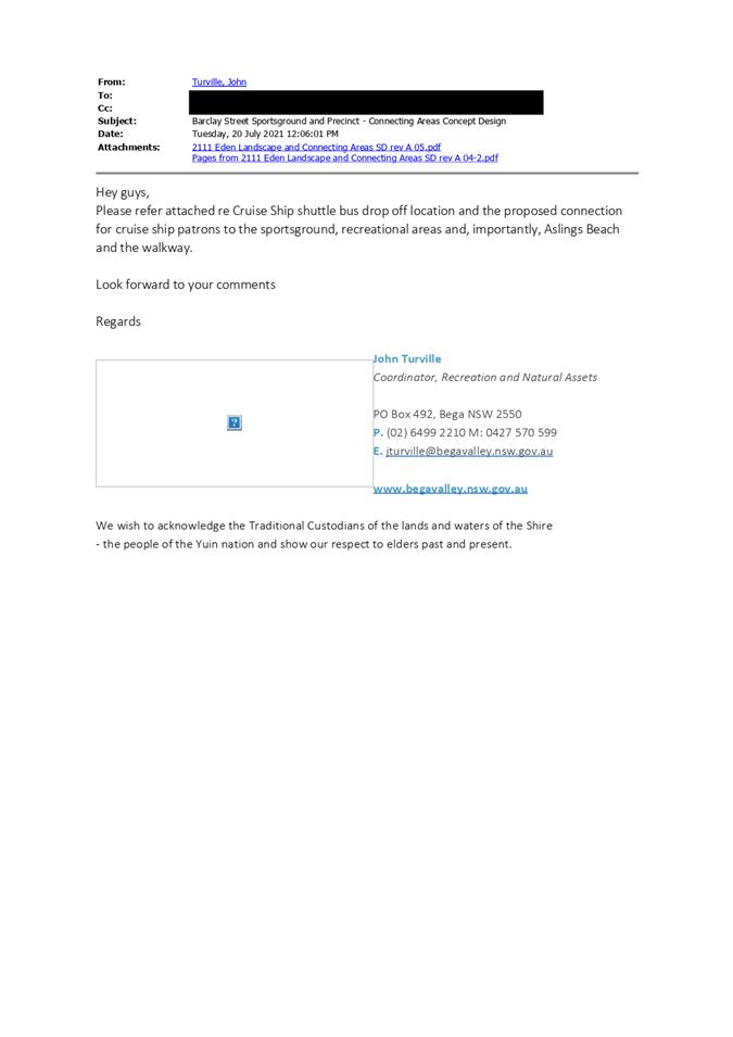
11.2. Eden Skatepark and Connecting Areas - Concept Designs
This report provides an update on the concept designs for the Eden skatepark and connecting areas with a view to seek endorsement of these concepts from Council.
Director Assets and Operations
1. That Council receive and note the information in the report.
2. That Council endorse the final concept designs for the Eden skatepark and the connecting areas.
3. That Council delegate authority to the Chief Executive Officer to procure any supply items specified by the respective landscape architects.
4. That Council delegate authority to the Chief Executive Officer, if required, to endorse amendments to the design to fit within the project budget.
Executive Summary
The Barclay Street Sportsground is about to undergo redevelopment that will see this recreational and sporting precinct become a key location for play and skate activity for the local community as well as a major recreational attraction for visitors to the shire.
This report presents two concept designs for endorsement by Councillors. The Eden skatepark and the areas of connection that link the skatepark to other areas of recreation such as the all-inclusive playspace, the playing fields, sportsground pavilions and nearby Aslings Beach.
Background
Having received funding in December 2018 under the Stronger Country Communities Fund (Round 2) to upgrade the Barclay Street Sportsground Precinct (new pavilion, sportsground lighting, grandstands and shelters), a master planning exercise for future development of the precinct was undertaken. This Masterplan was ultimately endorsed by Council in August 2020 and since that time Council has been successful in securing funds to construct an upgraded skatepark, provide links between the various areas of recreational activity and to help the site function better during an emergency event. Details of funding available for various elements of the upgrade is provided in the section titled “Financial and Resource Considerations”.
The concept design for the Eden all-inclusive playspace was approved by Council in December 2020 with the detailed design of this playspace almost completed.
Securing funding for the Eden skatepark (NSW Govt. – Stronger Country Communities Fund Round 3 and Federal Govt. – Building Better Regions) and then the connecting areas (NSW Govt. – Everyone Can Play and the Federal Govt. - BLER) has meant that a significant portion of the masterplan concept could be advanced through engagement of a designer/ landscape architect to commence the design process for these respective and interrelated projects.
Options
1. Council endorse the attached final concept designs enabling specific items to be sourced and the project to progress to detailed design, procurement and then construction.
2. Council does not endorse the final concept design; noting that this will impact on the project program and project delivery.
Community and Stakeholder Engagement
Engagement undertaken
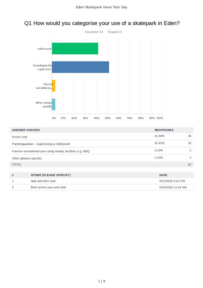
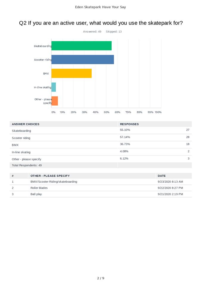
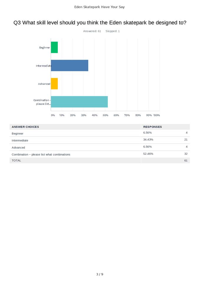
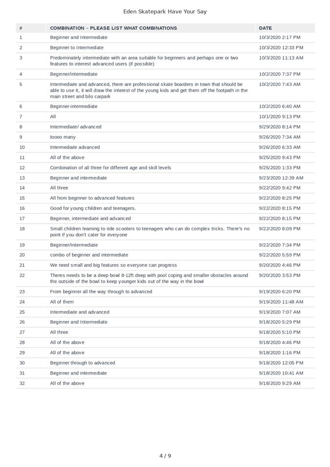
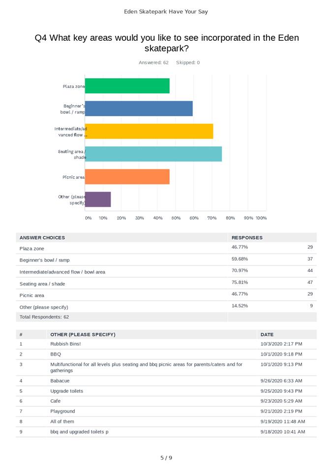
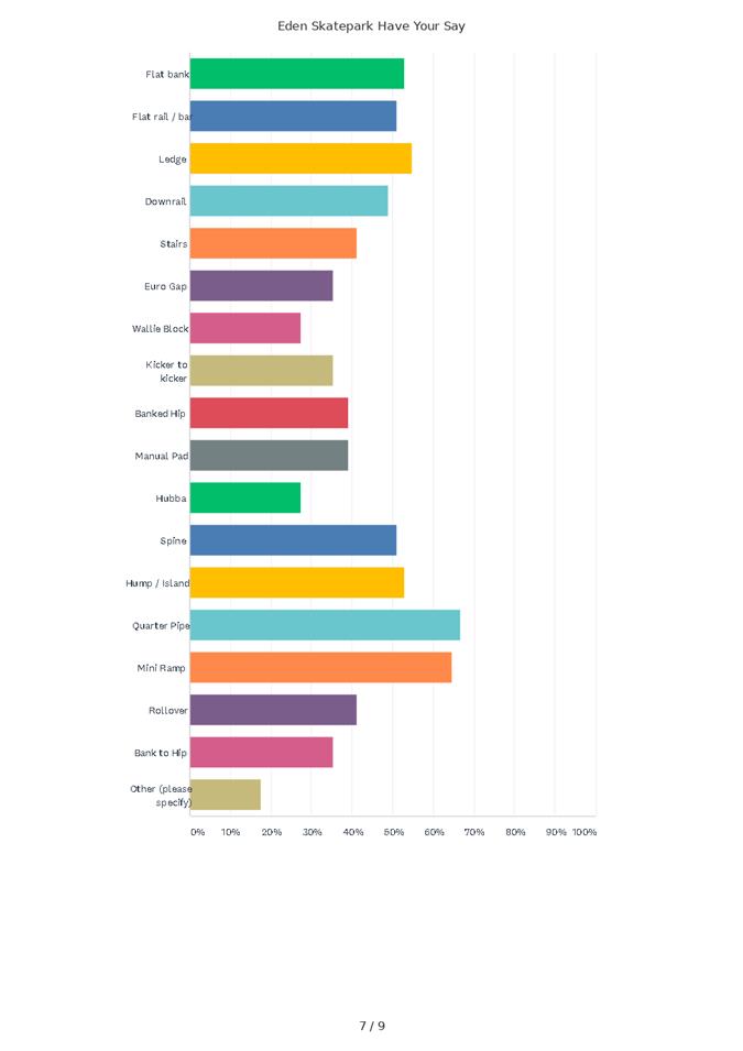
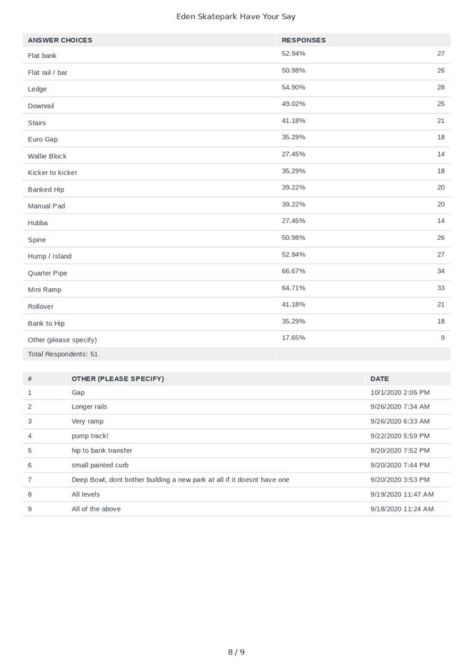
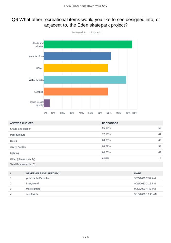
In September 2020, Council conducted an on-line survey to canvass the community’s interest in the skatepark project and understand what sort of skatepark the Eden community wanted. The timing of this online survey coincided with the community feedback session undertaken for the Eden all-inclusive playspace. The results of this on-line survey have been provided to the skatepark designer and are provided in the attachments to this report.
Further to this initial community engagement activity, a community advisory group (CAG) for the skatepark project was formed consisting of the following stakeholder groups:
· Access Inclusion Advisory Committee
· Eden Skatepark Committee
· Barclay Street Sportsground
· Aboriginal community members
This group, particularly the two Eden Skatepark Committee representatives, have been proactive in dealing with Council as well as the skatepark design consultancy (Baseplate) to agree the Skatepark concept design.
The level of engagement undertaken with the connecting design aspect of this project so that the design links the disparate recreational areas in a harmonious and organised manner, has involved liaising with the two community advisory groups established for the Eden all-inclusive playspace and the Eden skatepark projects.
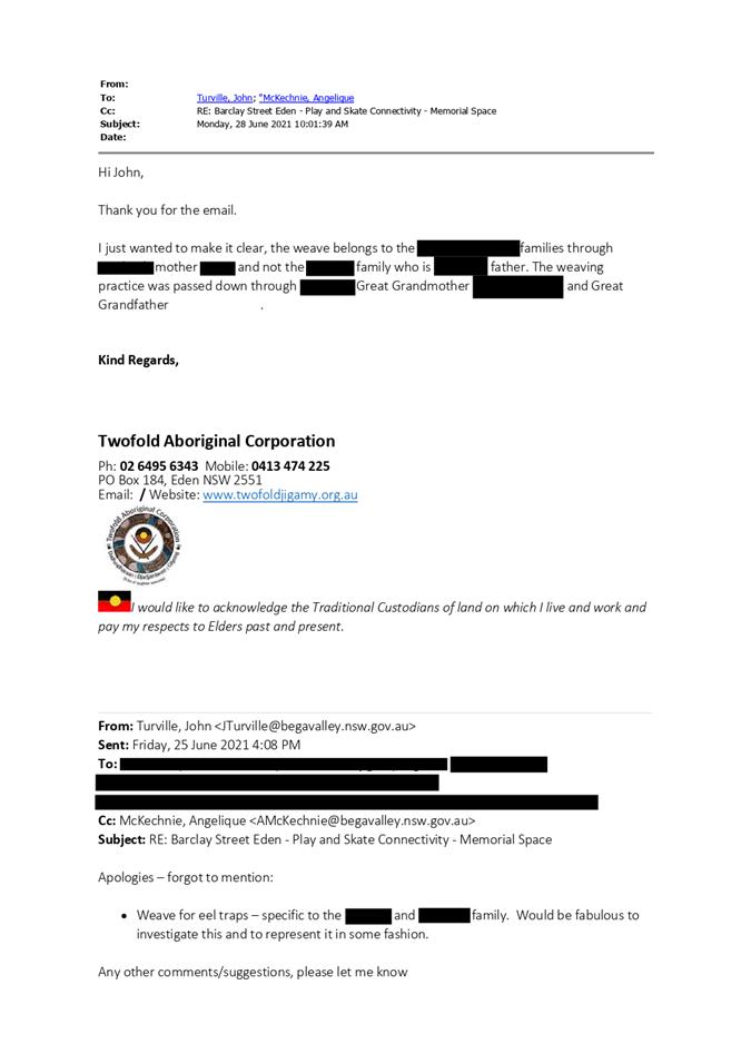
Further to this community consultation, Council staff have met with the immediate family members of a young Aboriginal woman who took her own life at the Barclay Street Sportsground in 2016. In addition to engaging directly with the family, Council staff has liaised with both the Eden LALC and Twofold Aboriginal Corporation to discuss the nature of the development being undertaken at Barclay Street and how to pay respect to this young woman in redeveloping this site. The connecting areas design incorporates cultural elements significant to the family of the deceased as well as to the wider Aboriginal community.
With respect to the Cruise Ship bus drop off and turning bay, Council staff met with key stakeholders involved with the Cruise Ship Shuttle Bus operation to determine the details of the bus drop off and turning bay location.
Engagement planned
Further engagement and consultation will occur as required during the detailed design phase of the project especially with respect to fine tuning elements of both designs.
Financial and Resource Considerations
The table below provides the income and expenditure envisaged from elements of both concept designs. At this stage, there are two main exceptions to this, these being:
· the Cruise Ship shuttle bus drop off and turning bay – item 1 on the Concept Plan, and
· the future proposed amenities building – item 14 on the Concept Plan.
Both elements are currently unfunded.
|
Item |
$ Excl GST |
|
Expenditure Detail |
|
|
Detailed design |
$100,000 |
|
PM and Contingency Fees |
$65,000 |
|
Planning and Approvals |
$45,000 |
|
Construction – Skatepark |
$550,000 |
|
Construction – Playspace |
$200,000 |
|
Supply – Play Equipment |
$160,000 |
|
Supply – Park Furniture |
$45,000 |
|
Construction – Connecting area (Memorial space, BBQ, shelters, etc.) |
$210,000 |
|
Construction – Revised entrance road and carparking |
$400,000 |
|
Construction – Aslings Beach crossing |
$50,000 |
|
|
|
|
Total Expected Expenditure |
$1,825,000 |
|
|
|
|
Source of Funds |
|
|
Stronger Country Communities Fund - Round 3 (Regional NSW) |
$300,000 |
|
Building Better Regions (Federal Department of Industry, Science, Energy and Resources) |
$375,000 |
|
Everyone Can Play (NSW Department of Planning, Industry and Environment) |
$300,000 |
|
Bushfire Local Economic Recovery Fund (Regional NSW) |
$450,000 |
|
Community Development Grants (Federal Department of Infrastructure, Transport, Regional Development and Communications) |
$400,000 |
|
Total Income Available |
$1,825,000 |
|
|
|
|
Total Project Capital Cost |
$1,825,000 |
|
Total Available Construction Funding |
$1,825,000 |
|
Project Funding Shortfall |
Nil |
Financial Option Impacts | Life Cycle Costing
|
Ongoing Financial Impacts |
$ Excl GST |
|
Capital Investment | Renewal (todays $) |
$1,825,000 |
|
Annual maintenance and operational costs |
$5,000 |
|
Depreciation costs |
$20,000 per annum |
|
User charges (annual income) |
Not applicable |
Legal /Policy
The Barclay Street Sportsground and Recreation Precinct falls over several Lots as set out in the table below:
|
Lot and DP |
Area within sportsground |
Status |
|
Lot 29, DP 705205 |
Eden Tennis Courts and Skatebowl Reserve |
BVSC Managed Crown Reserve #580070 |
|
Lot 9, DP 848111 |
AFL/Cricket Field |
Council owned and managed |
|
Lot 8, DP 848111 |
Soccer Field |
Council owned and managed |
Council staff have undertaken a Native Title Assessment and there are no constraints for these developments to be undertaken.
Council staff are currently working through the process of closing a council public road reserve that bisects the Barclay Street Sportsground Precinct. This road closure was reported to Council on 21 April 2021 and it was subsequently resolved by Councillors to proceed as per the officer’s recommendations.
Planning approvals regarding development of recreation facilities are often addressed under Division 12, Parks and other Public Reserve of the State Environmental Planning Policy (Infrastructure) (ISEPP 2007). The construction of these elements of the sportsground and recreational precinct falls under Section 65 of ISEPP 2007 being Development Permitted without Consent. A Review of Environmental Factors (REF) has been prepared for these developments and is currently with BVSC’s planning department for their endorsement.
Council officers are currently working with an archaeologist to work through Aboriginal heritage matters on site.
Impacts on Strategic/Operational/Asset Management Plan/Risk
Strategic Alignment
2021/22 Operational Plan:
OUTCOME 1: Active and Health Communities
Goal 2: We are an active, healthy community with access to good quality recreation and sporting facilities, and medical health care.
Delivery Program 1.2.4: Construct recreation facilities, boating infrastructure, public toilets and sporting grounds and facilities.
1.2.4.2 Progress detailed planning, tendering and construction of the Eden Inclusive Playspace.
1.2.4.3 Progress detailed planning, tendering and construction of the Eden Skatepark
Environment and Climate Change
There is no risk to the environment or ecological matters as the site is parkland with existing native vegetation. A small number of trees have been identified for removal due to their poor health and subsequent risk to users of the parkland area, and also to accommodate certain aspects of infrastructure in the respective concept designs. The impact associated with the removal of a small number of trees will be offset by the extensive planting that will occur following completion of the play and skate precinct.
Where practicable, Council will utilise trees, rocks and timber logs from their own stockpile/resources as ‘nature play’ based elements in the delivery of the playspace.
Economic
The development of this sportsground and recreation (play and skate) precinct will benefit local businesses as well as the welfare of the local community.
The project links directly to the ‘accessible and inclusive tourism markets’ and will be a welcome addition to Eden’s recreational opportunities.
Risk
The key risks for Council relate to delivering these projects within the project timeframe and within budget.
The various funding deeds related to each aspect of the project have provided a comfortable timeframe for design, planning, procurement and delivery. Having these two concept plans endorsed by Council at this stage of the design and planning phase of the project ensures that the timeframes remain on track.
Costs associated with its delivery will not be finalised until Council staff have been able to complete project procurement activities. It is noted that the attached connecting areas design includes some interesting and customised interpretive elements. Should project budgets be exceeded, Council may have to prioritise and rescope works or remove items from the delivery phase. As noted above, the respective Community Advisory Groups (CAG) will continue to be involved in design development and informed as project scope is finalised.
Social / Cultural
The development of this sporting and recreational precinct will provide significant benefits to the local community. On completion of this suite of projects, the Barclay Street Sportsground and Recreational Precinct will be an area that many locals and tourists will visit and enjoy.
Attachments
1⇩. Barclay Street Sportsground and Recreation Precinct - Connecting Areas concept Design
2⇩. Eden skatepark - Concept Design
3⇩. Eden Skatepark Committee - endorsement of skatepark design
4⇩. Sapphire Coast Skatepark Association - endorsement of skatepark concept design
5⇩. Email from Twofold Aboriginal Corporation_re: Memorial space
6⇩. Email to Cruise ship stakeholders
7⇩. Skatepark "Have Your Say" survey results
8⇩. Design review email from NSW Government - DPIE (Everyone Can Play)
9⇩. Email of support from Community Advisory Group member
10⇩. Email of support from Cruise Eden
|
Council |
18 August 2021 |
|
Item 11.2 - Attachment 1 |
Barclay Street Sportsground and Recreation Precinct - Connecting Areas concept Design |


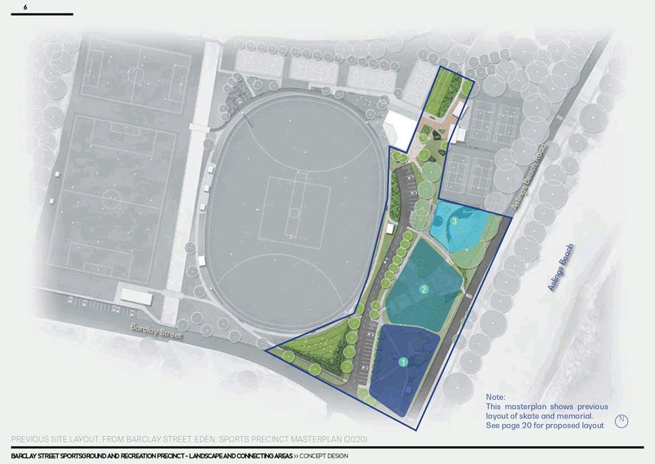

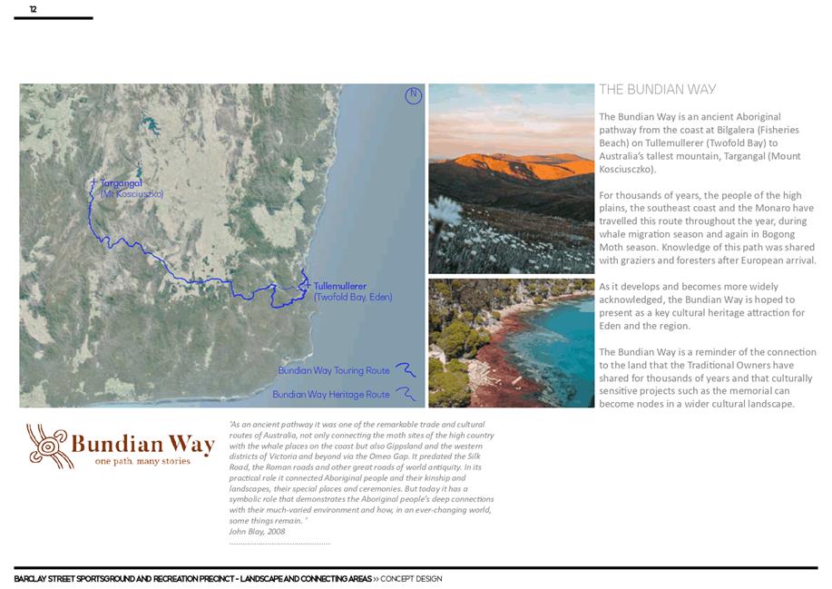
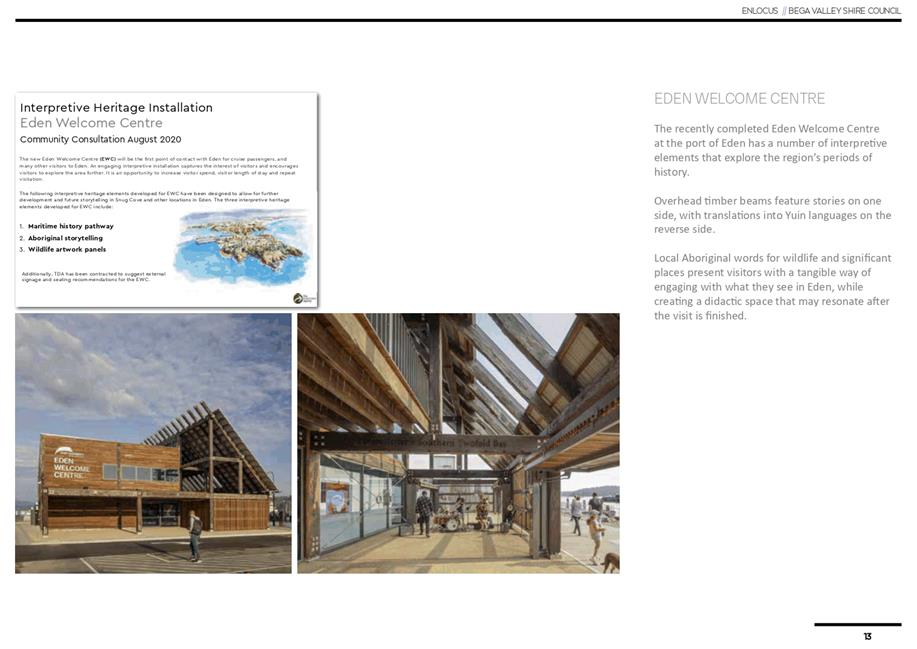
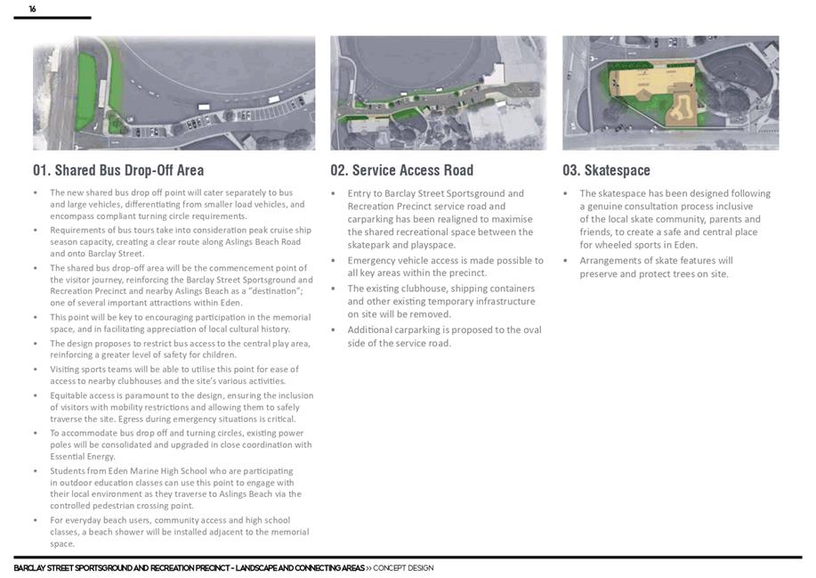
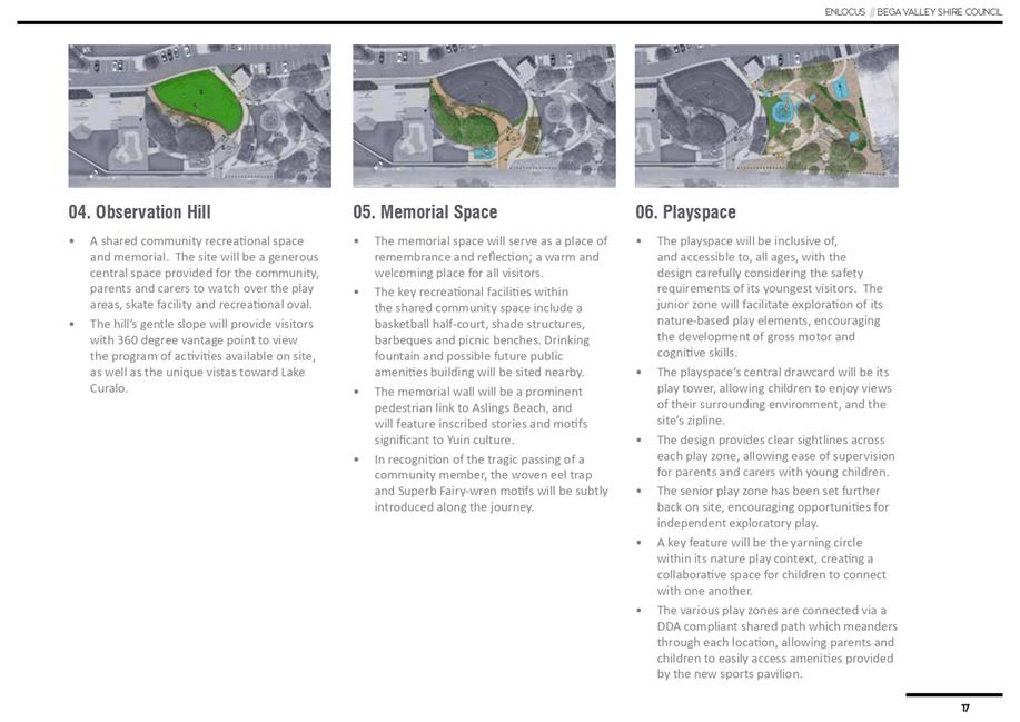

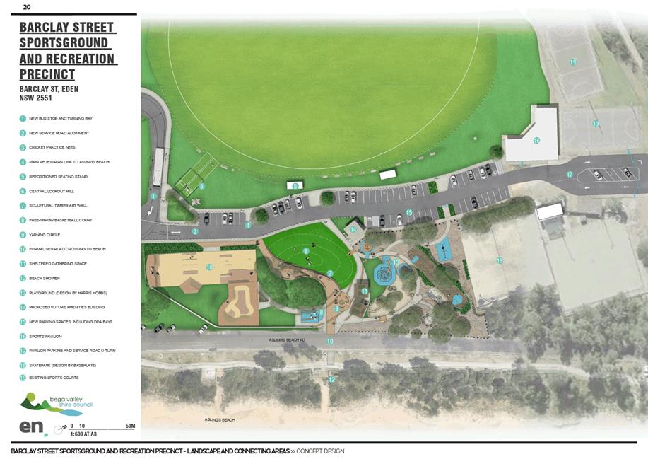
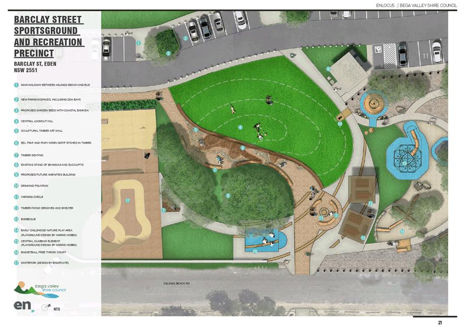
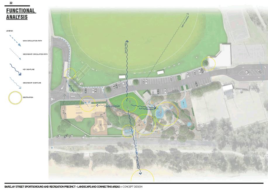
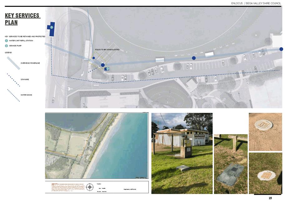
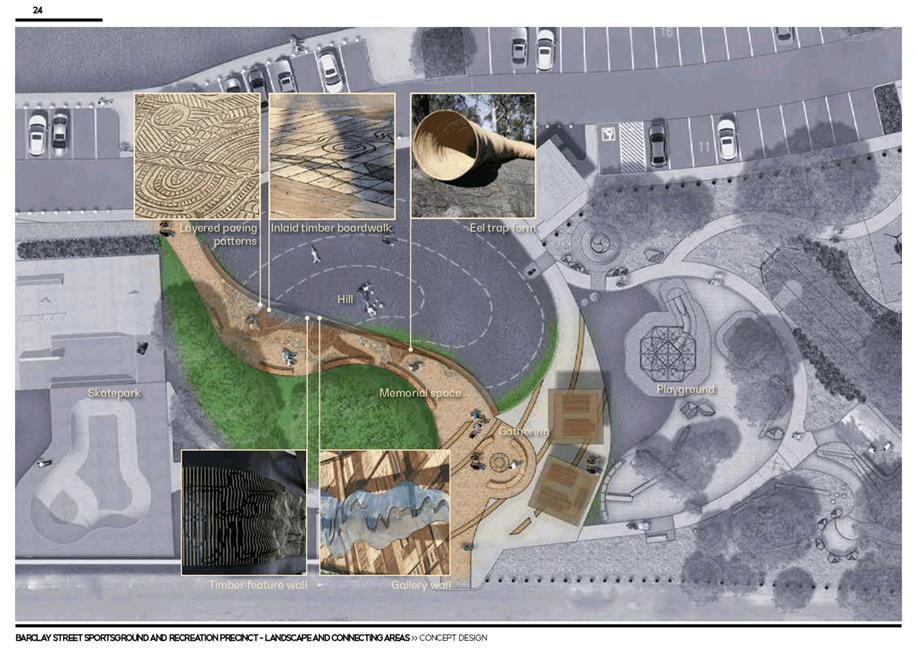
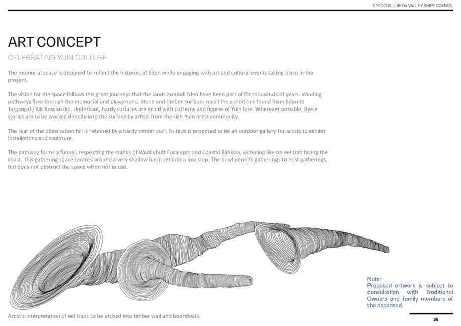
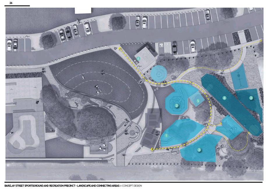
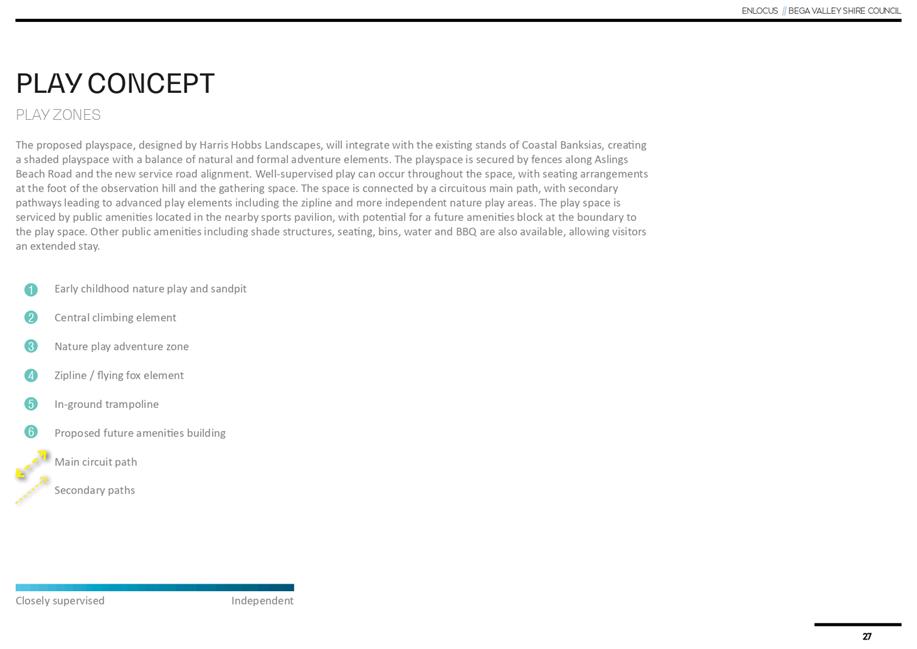
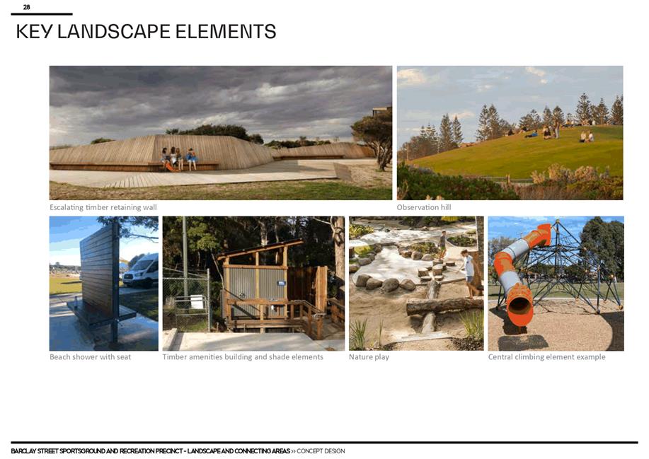
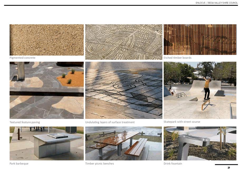
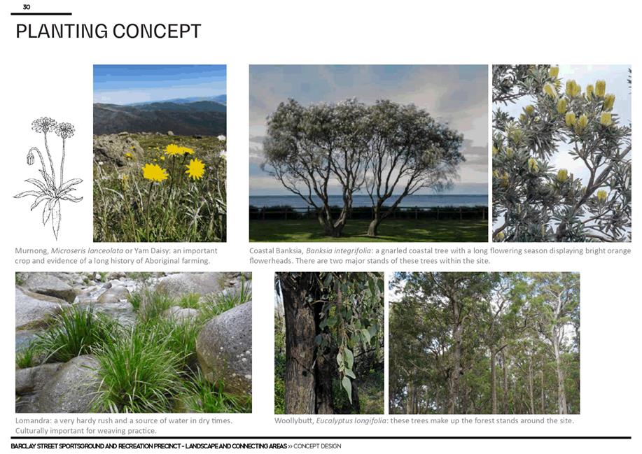
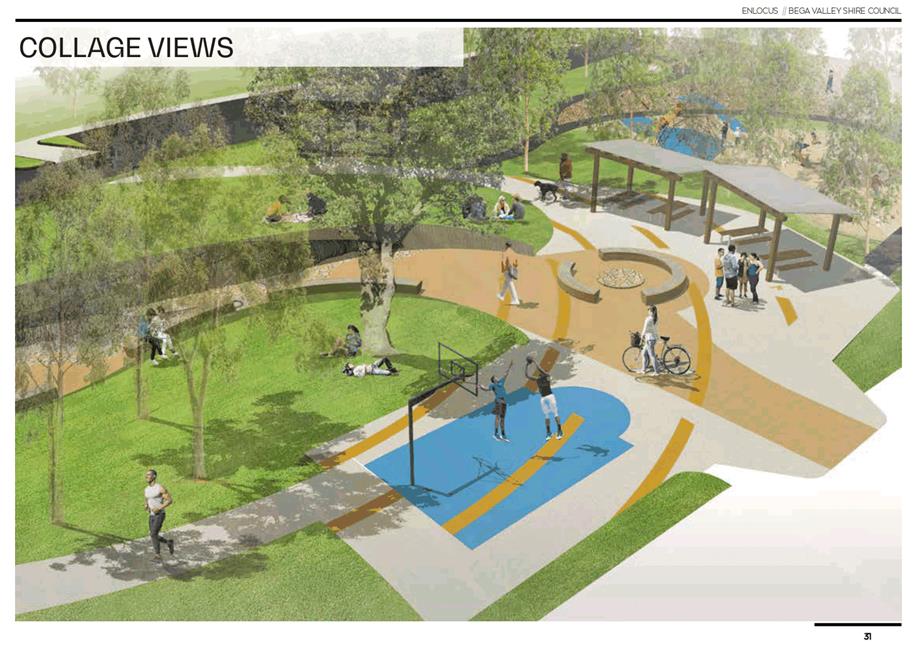
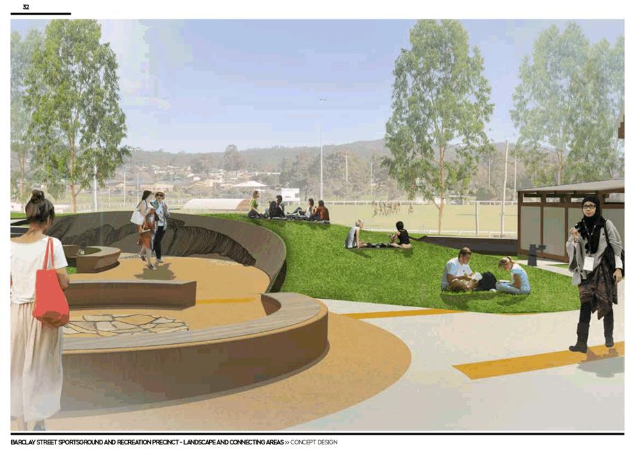
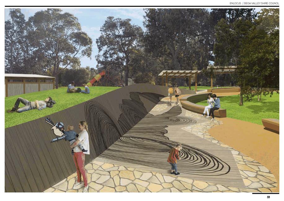
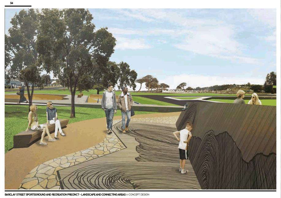

|
18 August 2021 |
|
|
Item 11.2 - Attachment 3 |
Eden Skatepark Committee - endorsement of skatepark design |
|
Council |
18 August 2021 |
|
Item 11.2 - Attachment 4 |
Sapphire Coast Skatepark Association - endorsement of skatepark concept design |
|
Council |
18 August 2021 |
|
Item 11.2 - Attachment 5 |
Email from Twofold Aboriginal Corporation_re: Memorial space |

|
18 August 2021 |
|
|
Item 11.2 - Attachment 8 |
Design review email from NSW Government - DPIE (Everyone Can Play) |

|
18 August 2021 |
|
|
Item 11.2 - Attachment 9 |
Email of support from Community Advisory Group member |
Council |
18 August 2021 |
12.1 Report on Implementation of Council's Operational Plan 2020-2021............. 300
12.2 Appointment of Councillor representatives to Committees and External Bodies. 380
|
Council 18 August 2021 |
Item 12.1 |
12.1. Report on Implementation of Council's Operational Plan 2020-2021
This yearly review provides Council with a status update on the delivery progress of the 2020-2021 Operational Plan.
Director Business & Governance
Council note the progress on the 2020-2021 Operational Plan from 1 January 2021 to 30 June 2021 and include Attachment 1 of this report with the 2020-2021 Annual Report.
Executive Summary
As at 30 June 2021, ninety-two percent (92%) of the 2020-2021 Operational Plan activities are listed as ongoing, completed or are on track to be delivered with some of the activities carrying over into the current 2021-2022 Operational Plan. Eight percent (8%) of activities were identified as off track.
Background
The purpose of the Operational Plan yearly review is to track the progress of activities outlined in Council’s Operational Plan for 2020-2021. With the 2020-2021 financial year having concluded it is important to consider the progress achieved in delivering the activities Council had committed to and how activities listed as off-track may impact the delivery of the current 2021-2022 Operational Plan. A break-down of progress by Directorate is provided in Figure 1.
The detailed update of Operational Plan activity status and achievements organised by Community Strategic Plan outcomes is provided in Attachment 1.
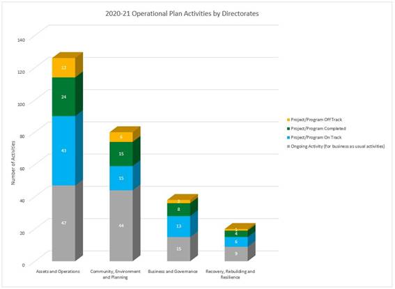
FIGURE 1
Options
There are no options presented for this receive and note report on the Operational Plan progress update.
Community and Stakeholder Engagement
Development of the Operational Plan and budget each year includes regular community engagement. Reporting at six monthly intervals provides accountability towards achieving the plan. The Business and Governance team utilise the communications team to develop rolling media coverage of IPR reporting across all platforms and social media posts on Council’s Facebook.
Engagement undertaken
Hardcopies of our Integrated Planning and Reporting documents are available to view at Council’s Bega office as well as Council’s Libraries at Bega, Bermagui, Eden and Tura Beach. All adopted documents and progress reports can be found on Council’s website.
Engagement planned
Attachment 1 of the report is recommended to be published and available on Council’s website.
Financial and Resource Considerations
The audited financial statements for FY21 are currently being compiled. It is recommended that further consideration of the progress in achieving the activities outlined in the 2020-2021 Operational Plan be undertaken in conjunction with the audited financials once they have been completed and published in the Annual Report. This progress report will form an appendix to the 2020-2021 Annual Report.
Fulfilling the requirements of Integrated Planning and Reporting Framework outlined in the Local Government Act 1993, is delivered as an operational function within the Business and Governance directorate.
Legal /Policy
Chapter 13 of the Local Government Act 1993 requires Council to report half yearly on the status of the Operational Plan.
Impacts on Strategic/Operational/Asset Management Plan/Risk
Strategic Alignment
The 2020-2021 Operational Plan was developed to align with the adopted Community Strategic Plan, Delivery Program, Resourcing Strategy and Long-Term Financial Plan.
The following is a list of some of the highlights for the period. Detailed reporting on all the Operational Plan activities is provided in Attachment 1.
Several highlights for the period:
· A review of community grants, scholarships and awards program has been undertaken
· A project reference group established to develop an Affordable Housing Strategy
· Launch of an exhibition space at Eden Welcome Centre BVRG: PORT
· Facility Management Plans for majority of Council’s sportsgrounds now in place
· Hazard reductions works continue in key asset protection zones in Tura Beach, Merimbula, Pambula and Eden
· Investment Prospectus finalised to assist Council with securing future grant funding
· Community engagement for renewal of Merimbula Boardwalk has commenced
· Delivery of multiple grant funded recreation infrastructure including the Bermagui River and Kalaru boat ramp upgrades, Bruce Steer Pool Coastal Accessibility Project, Pambula Beach Coastal Accessibility Project, Merimbula Ford Park Courts, Apex Park Bermagui Playground and Wallaga Lake & Camel Rock Walking Trail.
· Toilet block replacement completed in Wonboyn and concept designs on exhibition for new toilets in Cobargo
· Concept plan for Bega Swimming Pool endorsed
· Council participated in a CRJO collaborative project to develop a Regional Community Strategic Plan
· Finalisation of Pambula/Yowaka Rivers Flood Study
· LED lighting upgrades at 6 Council facilities
· Tender documentation has been finalised for the Bega Water Treatment Plant
· Development approval obtained for the airport runway extension project
Environment and Climate Change
There are no direct Environment and Climate Change implications associated with presenting this receive and note report.
Economic
Council and its expenditure have a significant economic impact on the Bega Valley. The preparation and publishing on our progress towards the implementation of the annual Operational Plan provides a line of sight between funding (budget) and delivery (operational plan actions) informing our community on Council’s contribution and commitment as a provider of a variety of public services.
Risk
Preparation of this Operational Plan progress update has not identified any significant strategic risks associated with delivery of our programs, projects and services. Operational risks that have the potential to impact delivery of our Operational Plan actions are managed by the leadership group and considered at weekly and monthly meetings, including appropriate risk mitigation and management actions. Those projects listed as off-track in this progress report are under further review.
Social / Cultural
The receive and note recommendation of this Operational Plan progress report does not have any negative social or cultural impacts. Associated funding and adjustments to the budget for delivery of our various services are reflected in the notes provided by responsible officers.
Attachments
1⇩. Attachment 1_ Op Plan Progress Report Jan-July FY21_FINAL
|
Council |
18 August 2021 |
|
Item 12.1 - Attachment 1 |
Attachment 1_ Op Plan Progress Report Jan-July FY21_FINAL |
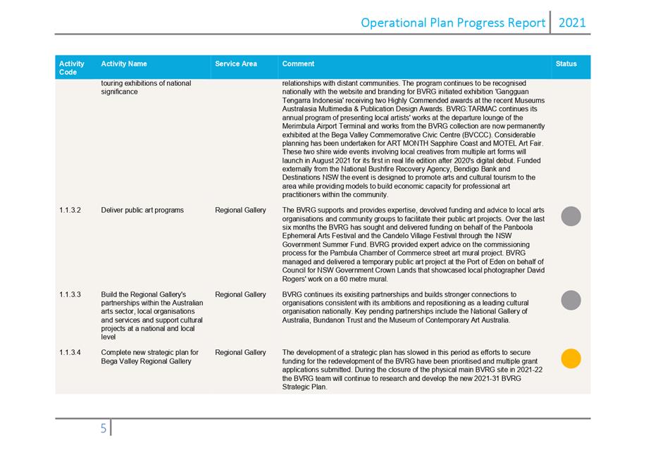
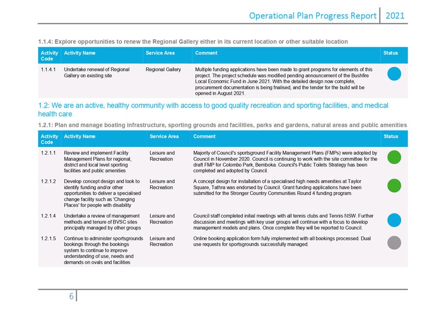
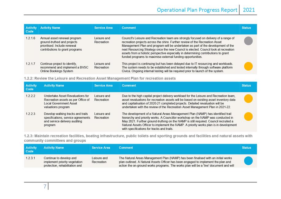
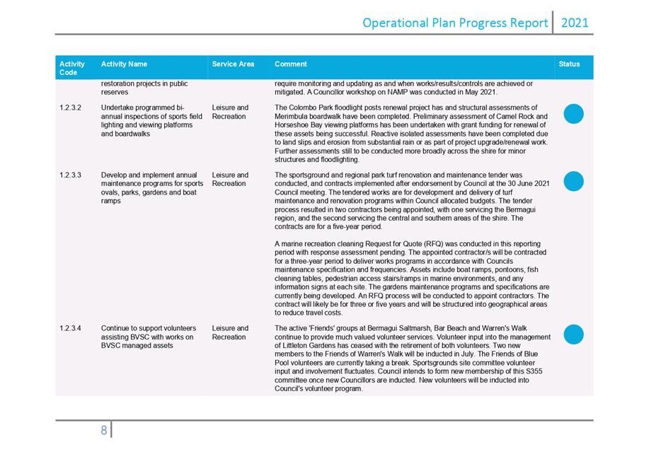
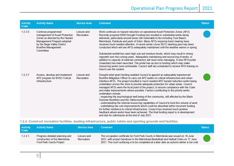
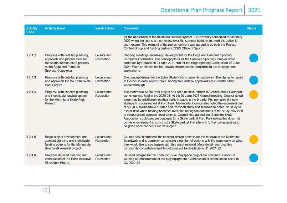
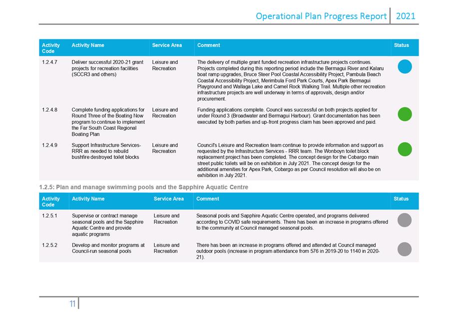
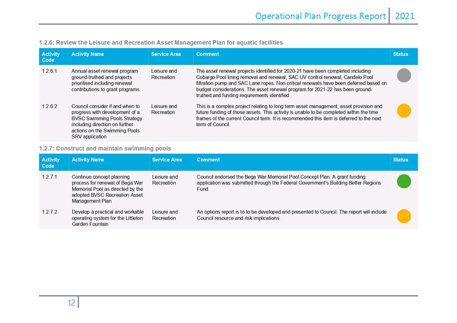
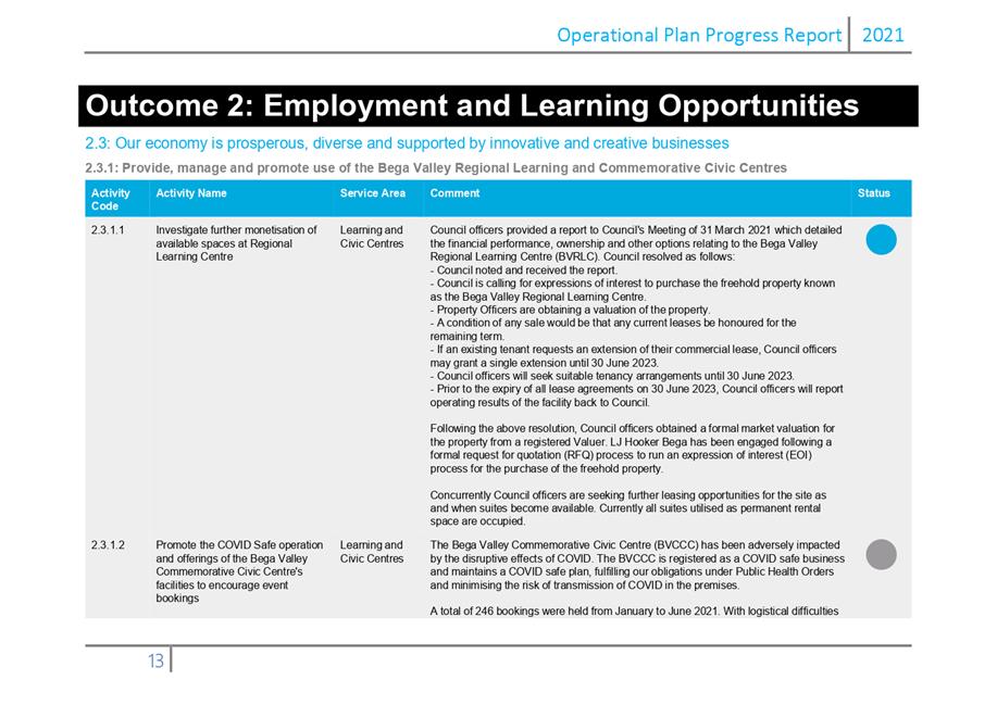
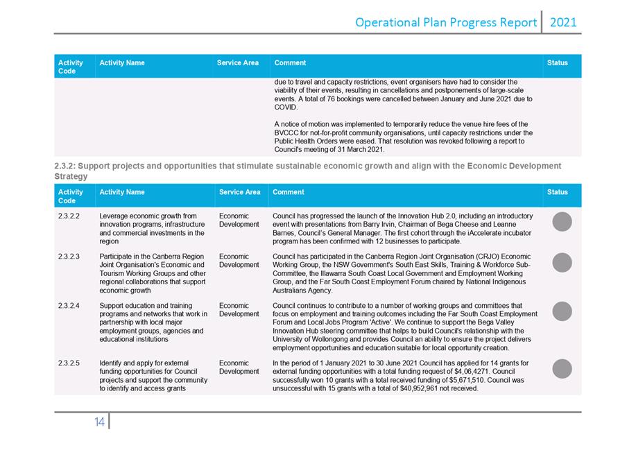
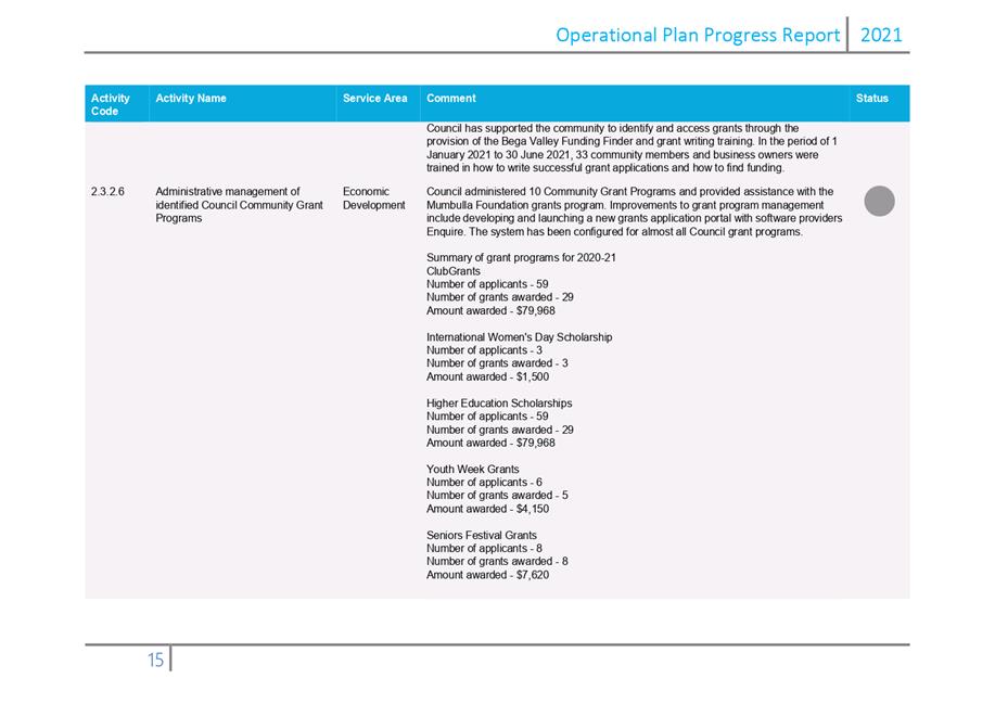
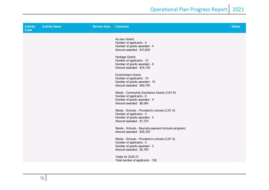
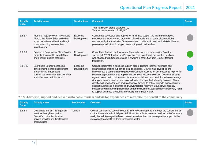
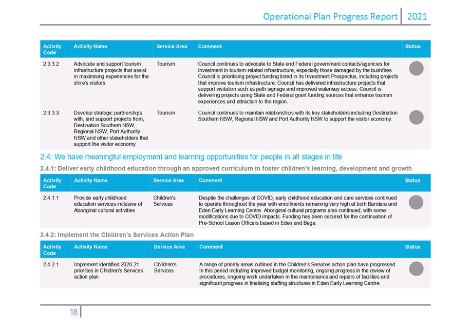
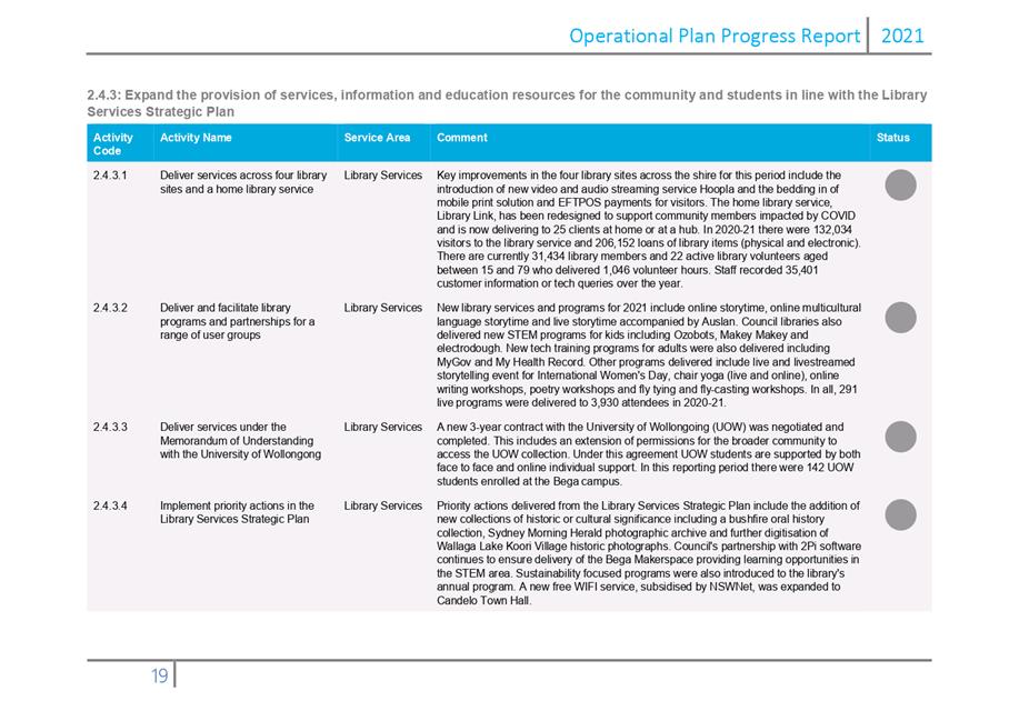
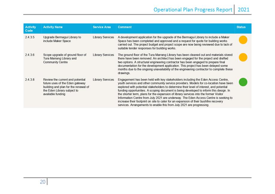
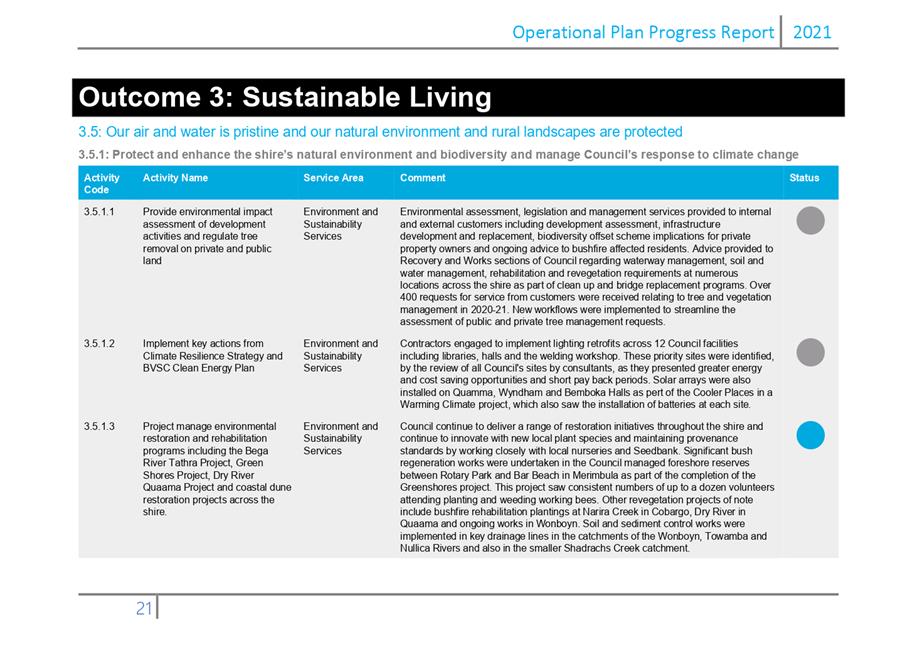
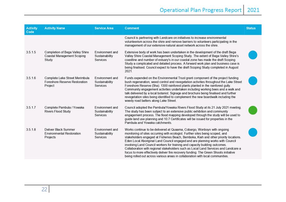
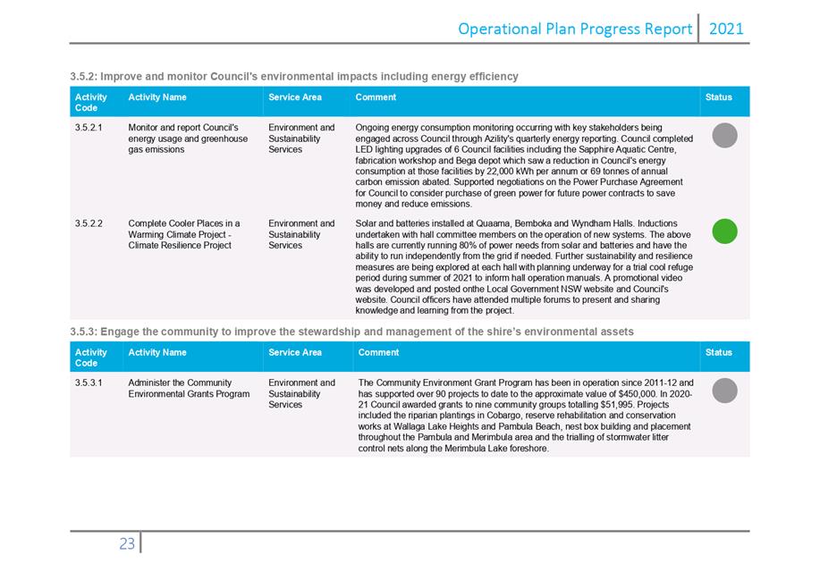
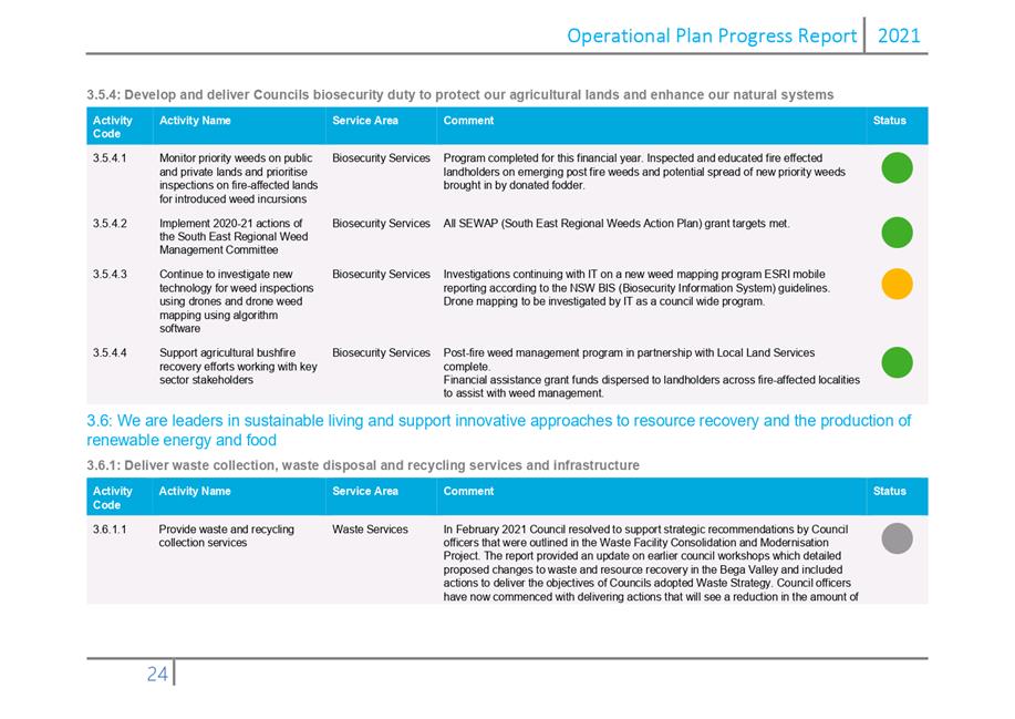
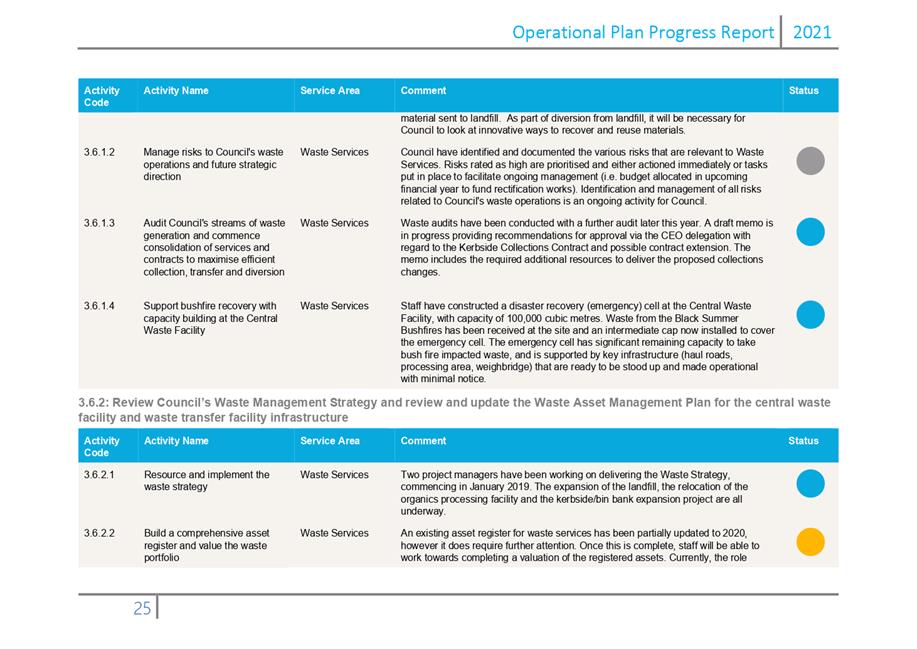
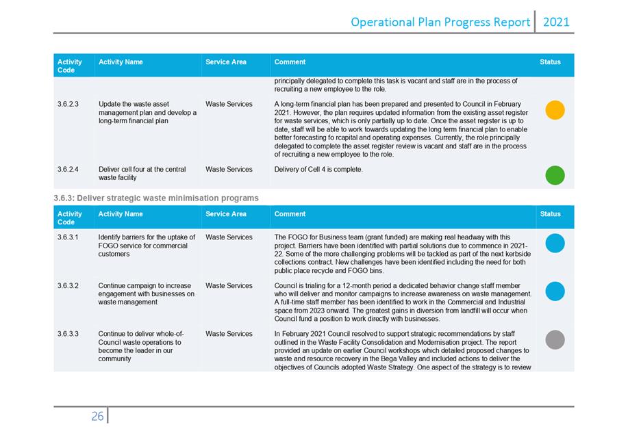
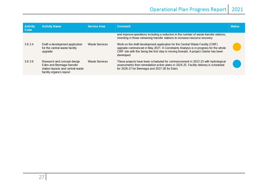
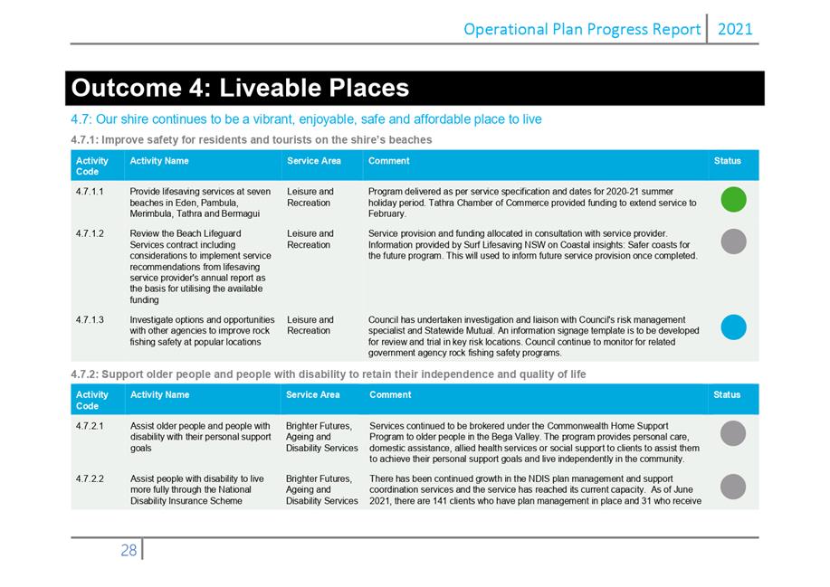
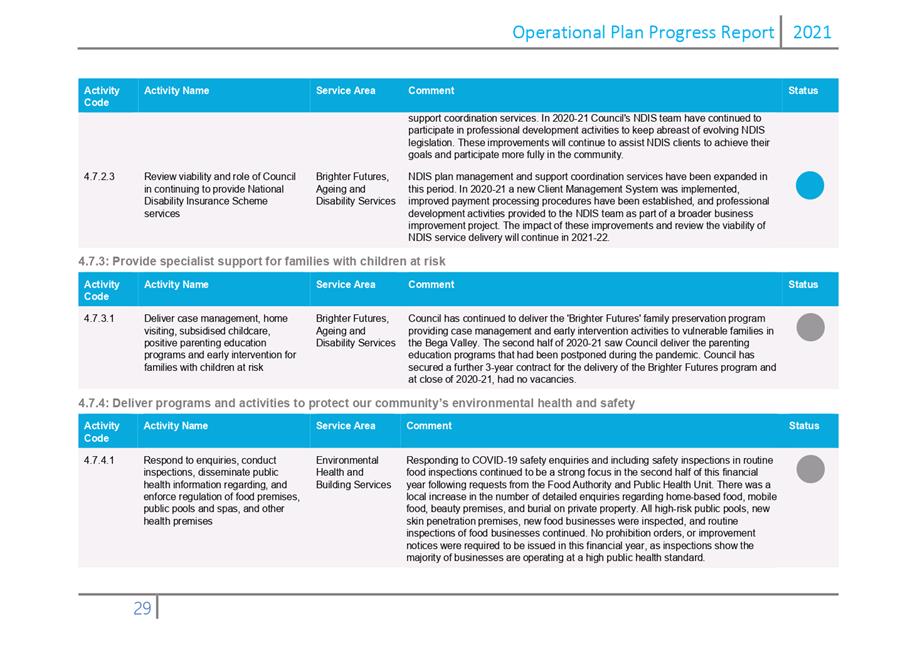
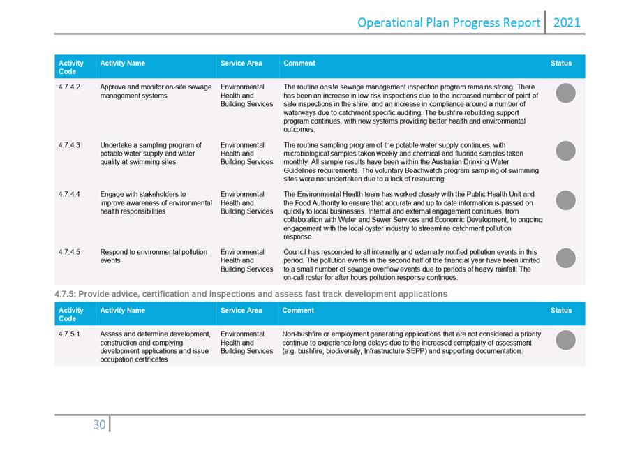
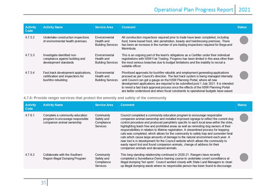
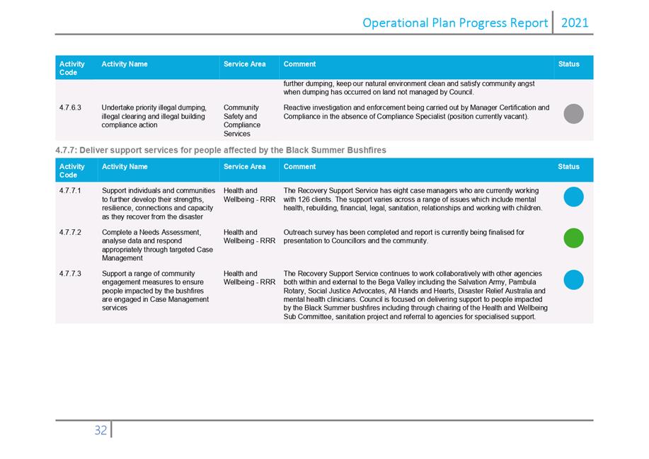
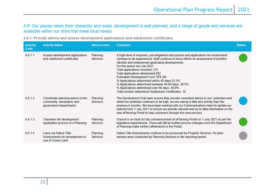
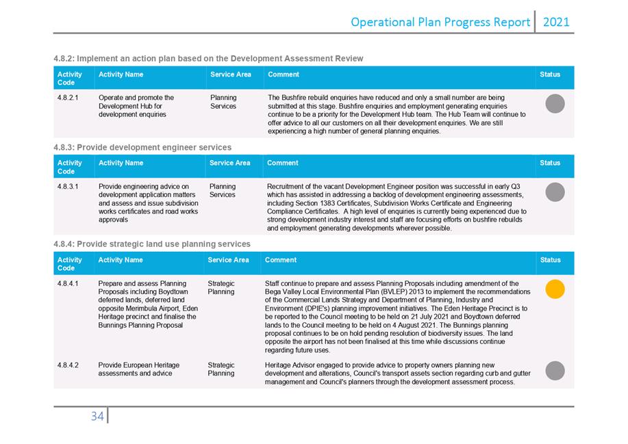
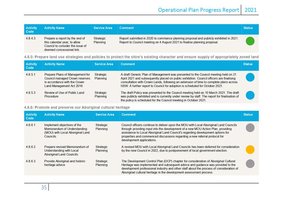
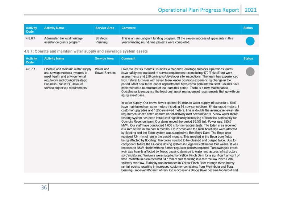
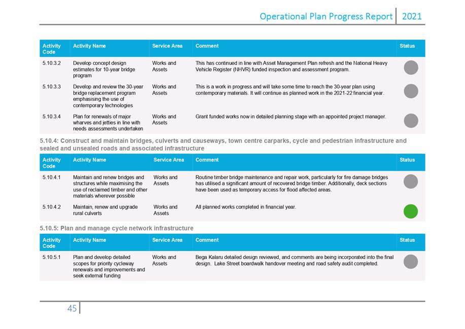
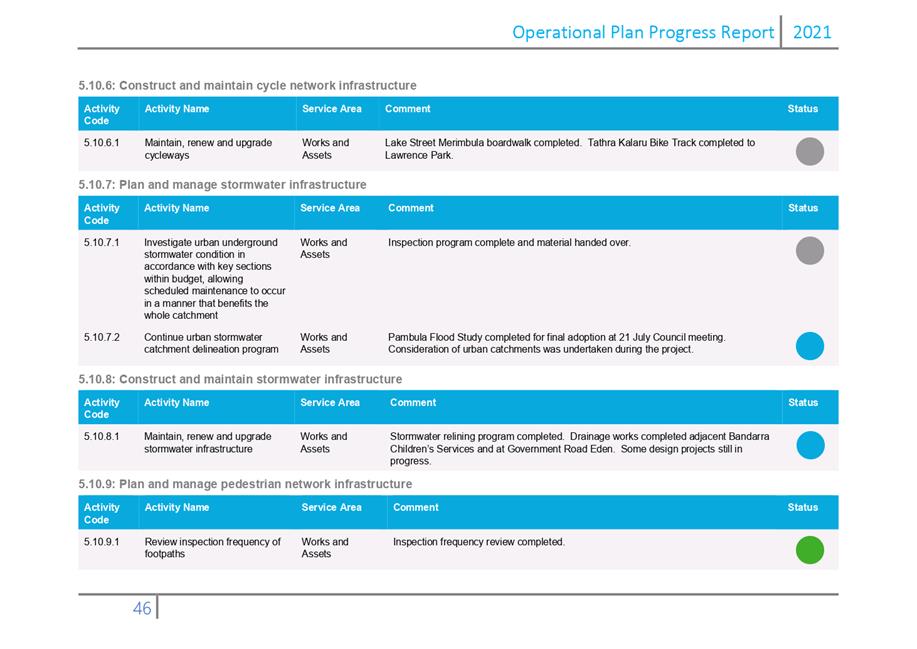
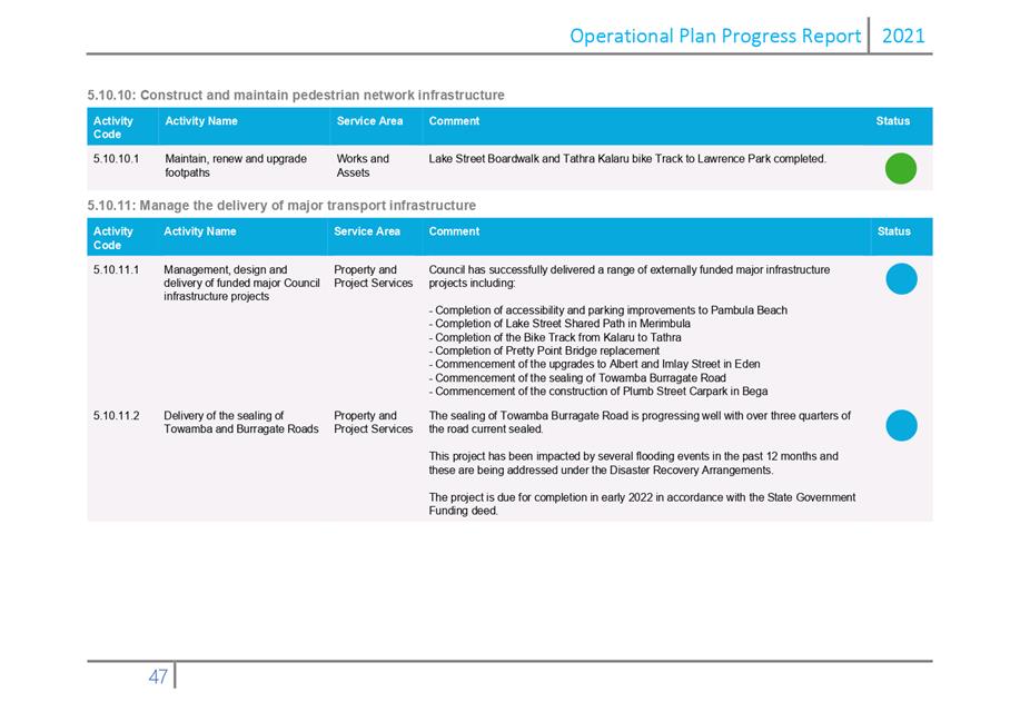
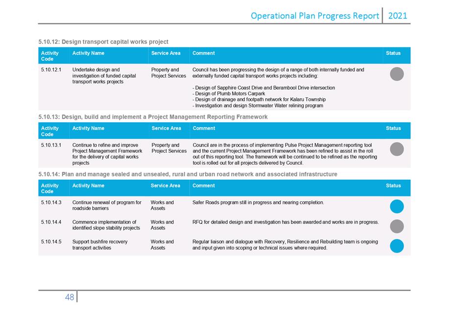
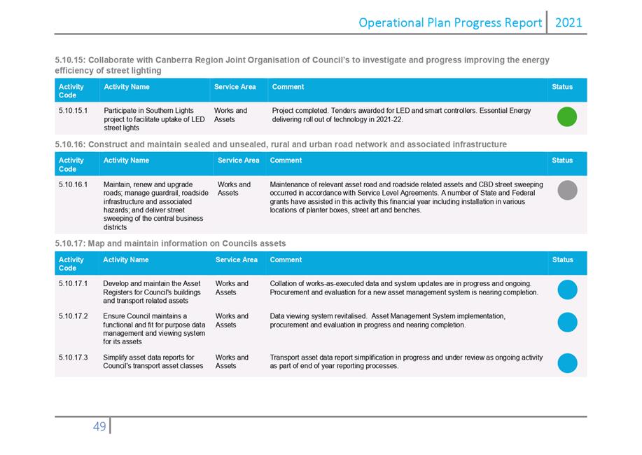
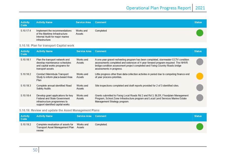
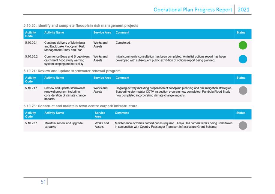
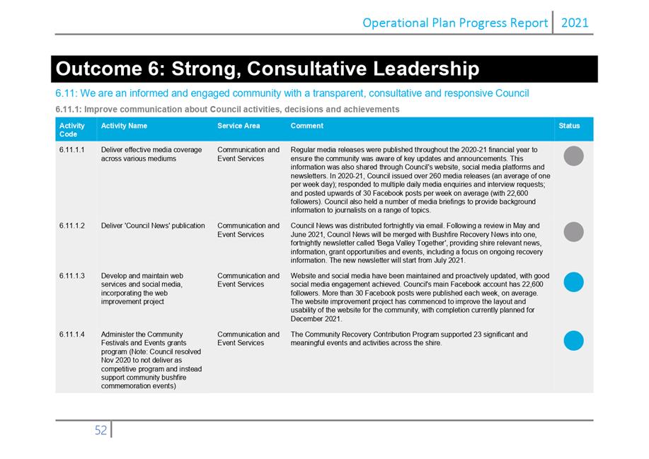
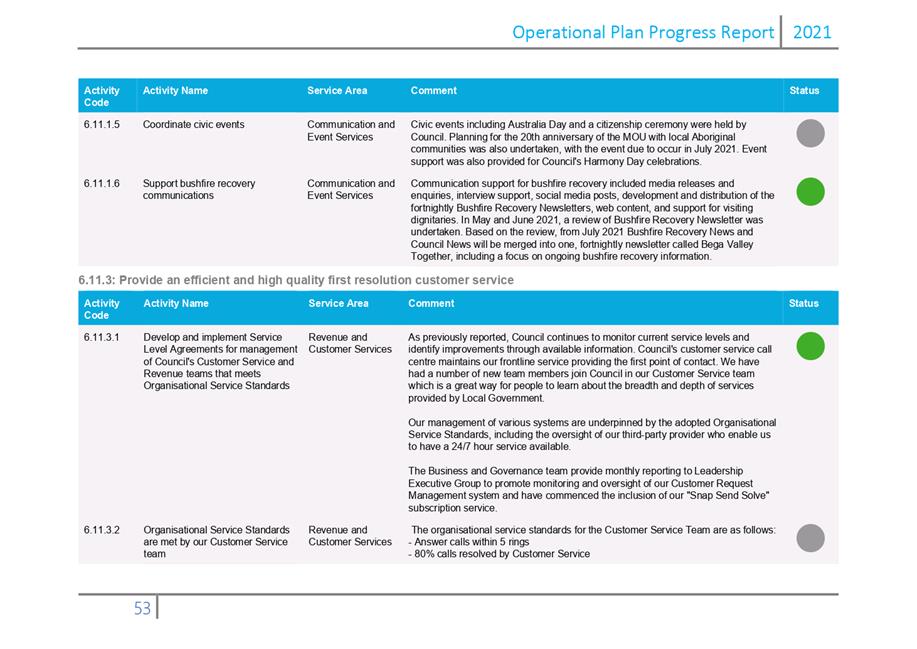
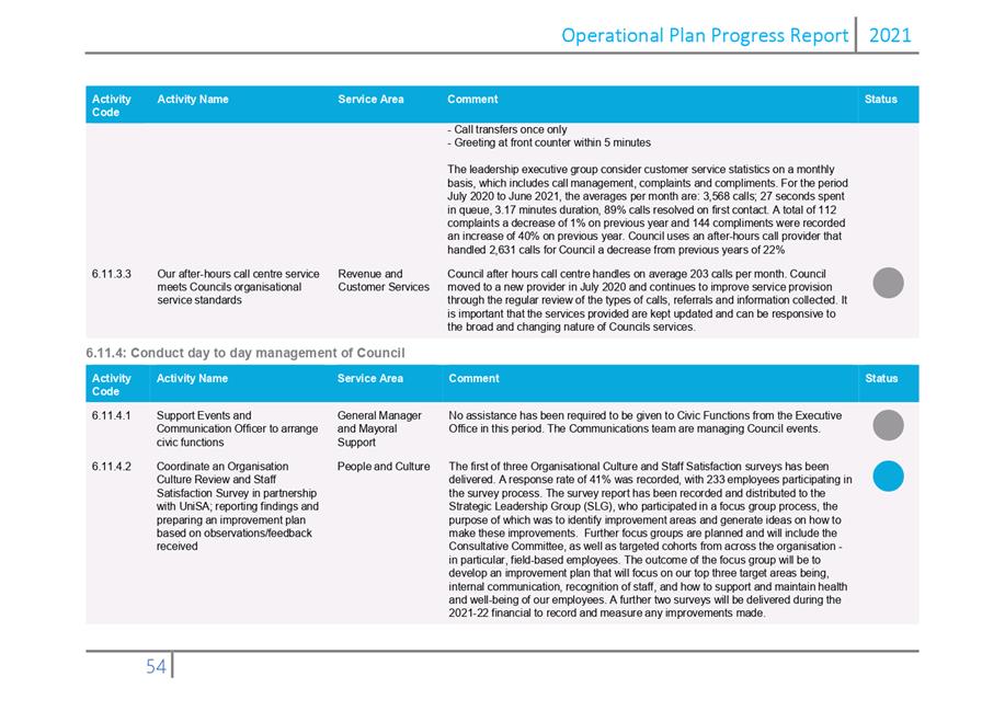
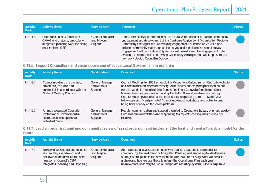
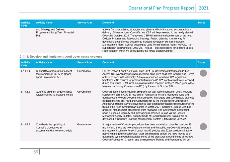
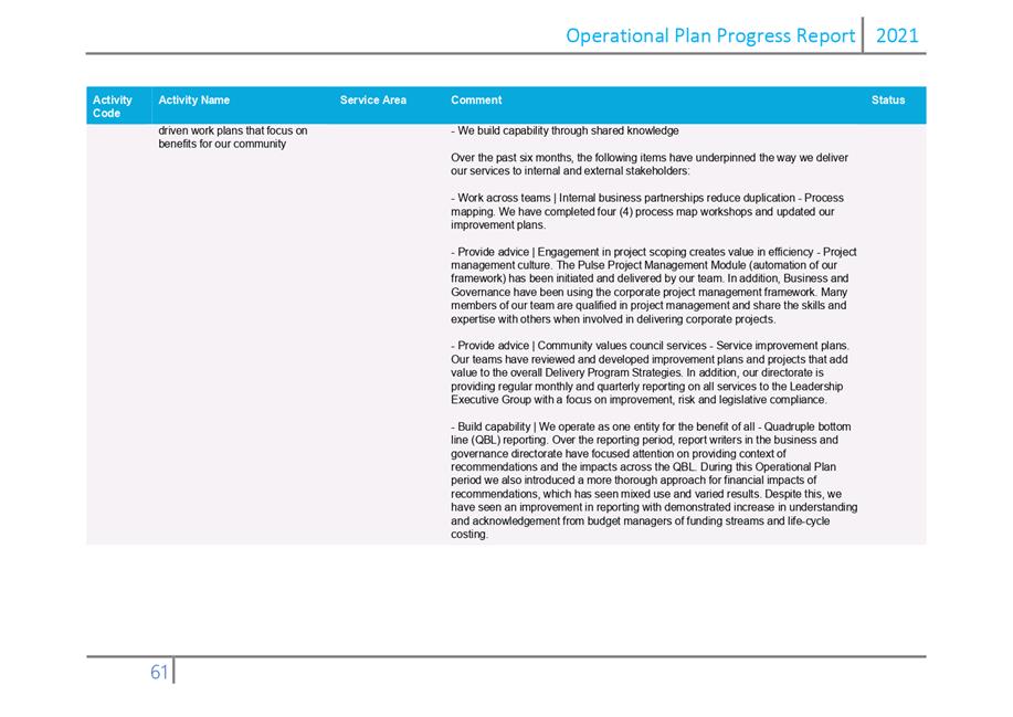
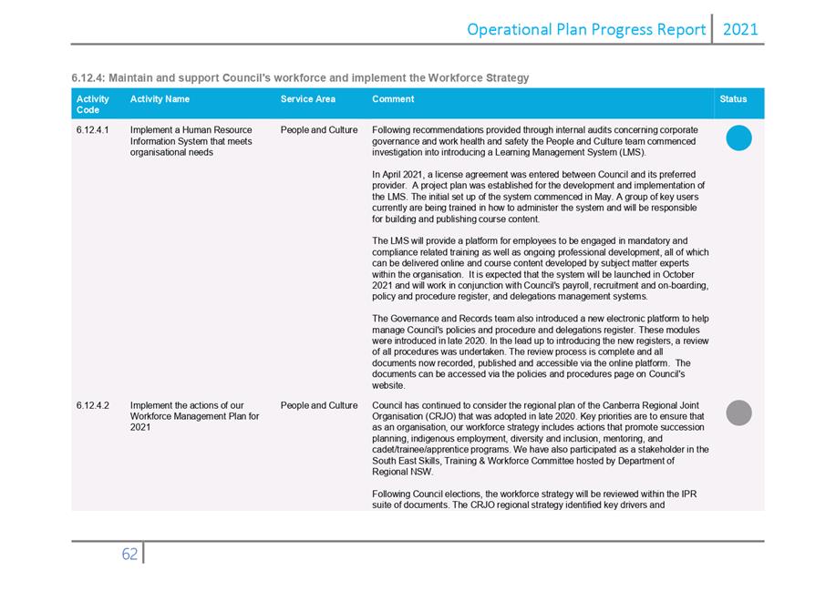
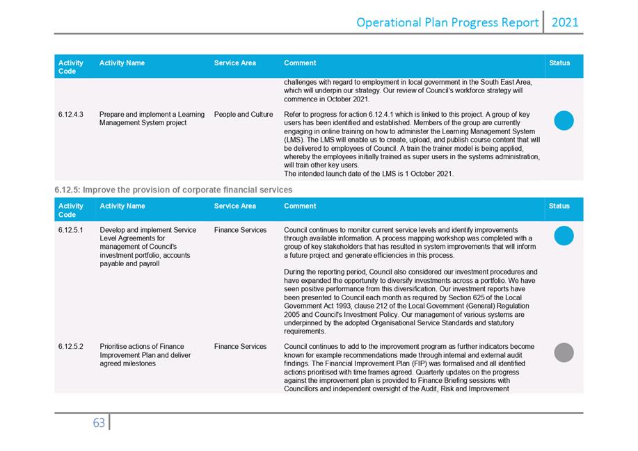
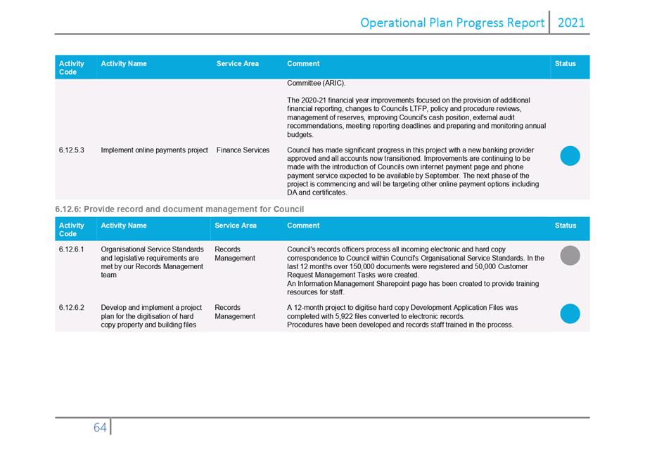
|
Item 12.2 |
12.2. Appointment of Councillor representatives to Committees and External Bodies.
Council needs to consider its representatives to committees and external organisations with the extension of the current Council term.Chief Executive Officer
1. That Council extend the appointment of the current delegates to positions as outlined in the table below until the next term of Council is elected.
2. That Council extend the term of current Section 355 committee members until the next term of Council is elected.
Executive Summary
Councillor delegates were elected for a two year period in September 2018 to:
· Council Committees (S355)
· Internal community committees and panels, and
· External organisations
Due to COVID-19 the Council term has been extended until 4 December 2021. This report seeks for Council to confirm the Councillor delegate appointments and external section 355 committee members until the next term of Council is elected.
Background
Council appoints committee and panel delegates and representatives for a range of Council and external committees. Council appointed these delegates by resolution in September 2018 for a two-year period and by resolution on 16 September 2020 extended these delegates until end 2021.
The current appointments are outlined in the tables below.
|
Council Section 355 Committee/Panel |
Delegate Representative Elected 2018/20 |
|
Access and Inclusion Committee |
Cr Bain |
|
Audit, Risk and Improvement Committee |
Cr Nadin Mayor Fitzpatrick |
|
Bega, Eden, Merimans Local Aboriginal Liaison Committee |
Mayor (alternates Crs Seckold and Dodds) Note: elected August 2019 |
|
Bega Valley Medallion Committee |
Mayor |
|
Coastal Planning and Management Panel |
Cr Seckold |
|
General Cemetery Advisory Committee |
Cr Dodds |
|
General Community Halls Committee |
Cr Bain |
|
General Sportsground Committee |
Crs Nadin and Allen |
|
Montreal Goldfields (committee established 26 August 2020 meeting) *Resolved at Ordinary Meeting of Council on 26 August 2020 |
Cr Seckold (Cr Dodds – alternative) |
|
Internal or Community Committee/Panel |
Delegate Representative Elected 2018/20 |
|
Awards and Scholarships Committee |
Mayor, Cr Seckold, Dodds and Nadin |
|
Bega Valley Community Disaster Relief Fund |
Cr Seckold Cr Dodds |
|
Central Waste Facility Community Consultation Committee (CWFCCC) |
Mayor |
|
Community Environment Grants Committee |
Crs Griff and Seckold |
|
Community Events and Festivals Grants Evaluation committee |
Crs Griff, Allen and Nadin |
|
Heritage Grants Committee |
Crs Dodds and Seckold |
|
Integrated Water Cycle Management Reference Panel |
Mayor |
|
Local Traffic Committee & Traffic Development Advisory Committee |
Cr Bain |
|
Police Liaison Committee |
Mayor |
|
External Groups Committee/Organisation |
Delegate Representative Elected 2018/20 |
|
Australian Coastal Councils Association Inc |
Cr Griff |
|
Batemans Marine Park |
Cr Dodds |
|
Bega Valley Bush Fire Management |
Cr. Bain (Cr Dodds – alternative) |
|
Bega Valley Business Forum |
Cr Fitzpatrick |
|
Biamanga National Park |
Cr Bain (Cr Seckold- alternative) |
|
Clean Energy for Eternity MoU |
Cr Dodds |
|
Country Mayor’s Association |
Mayor |
|
Canberra Region Joint Organisation (CRJO) |
Mayor (alternate Deputy Mayor) |
|
Local Government NSW (Council has 3 voting delegates at conference) |
Mayor, Crs Fitzpatrick, Griff – Annual Conference; resolved 2018 Mayor other LGNSW forums/meetings |
|
Mumbulla Foundation |
Cr Dodds |
|
NSW Public Library Association |
Cr Dodds |
|
South East Arts |
Cr Griff |
|
South East Australian Transport Strategy (SEATS) |
Mayor |
|
Southern Joint Regional Planning Panel |
Cr Dodds Cr Fitzpatrick Alternative 1 – Cr Nadin Alternative 2 – Cr Seckold |
Attachments
Nil
|
Council |
18 August 2021 |
Notices of Motion
18 August 2021
16.1 Support for businesses affected by COVID-19.................................................. 383
|
Council 18 August 2021 |
Item 16.1 |
That Council publicly exhibit proposed changes to Council’s adopted 2021-2022 Fees and Charges to waive the following fees described in Council’s Fees and Charges for businesses to use public land in the shire’s towns and villages:
b) Outdoor eating annual rental fees, and
c) Shopfront footpath displays, fixed premises signage fees.
Businesses in Bega Valley Shire have been significantly affected by natural disasters and the COVID-19 pandemic over the last 18 months. The most recent NSW lockdown is the latest blow to our already hard-hit local business community.
Council charges these businesses fees to advertise their business via footpath displays and fixed premise signage and to utilise public land for outdoor dining. As a small contribution to recognise the financial hardship these businesses are experiencing, Council should waive these fees. The loss of income to Council from these fees is expected to be in the order of $14,000. This revenue is expected to be more than offset by the increase in development-related fees, as the rate of development currently exceeds the amount of income allowed for in Council’s adopted 2021-2022 budget.
Cr Jo Dodds