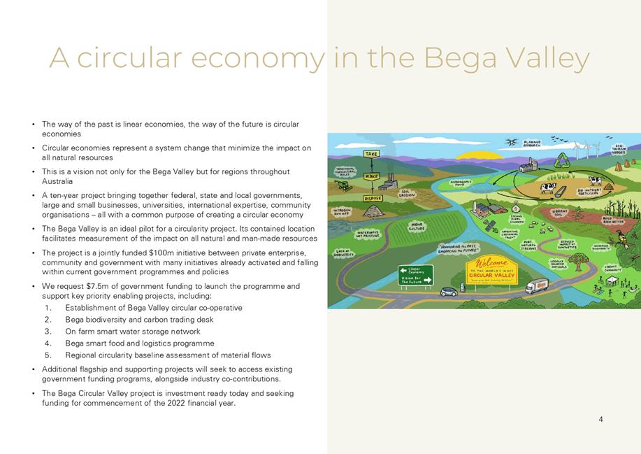
|
OrdinaryMeeting Notice and Agenda
An Ordinary Meeting of the Bega Valley Shire Council will be held at Council Chambers, Biamanga Room Bega Valley Commemorative Civic Centre
Bega on
|

|
OrdinaryMeeting Notice and Agenda
An Ordinary Meeting of the Bega Valley Shire Council will be held at Council Chambers, Biamanga Room Bega Valley Commemorative Civic Centre
Bega on
|
Council meetings are recorded and live streamed to the Internet for public viewing. By entering the Chambers during an open session of Council, you consent to your attendance and participation being recorded.
The recording will be archived and made available on Council’s website www.begavalley.nsw.gov.au. All care is taken to maintain your privacy; however as a visitor of the public gallery, your presence may be recorded.
The Agendas for Council Meetings and Council Reports for each meeting will be available to the public on Council’s website as close as possible to 5.00 pm on the Thursday prior to each Ordinary Meeting. A hard copy is also made available at the Bega Administration Building reception desk and on the day of the meeting, in the Council Chambers.
The Minutes of Council Meetings are available on Council's Website as close as possible to 5.00 pm on the Monday after the Meeting.
1. Please be aware that the recommendations in the Council Meeting Agenda are recommendations to the Council for consideration. They are not the resolutions (decisions) of Council.
2. Background for reports is provided by staff to the General Manager for presentation to Council.
3. The Council may adopt these recommendations, amend the recommendations, determine a completely different course of action, or it may decline to pursue any course of action.
4. The decision of the Council becomes the resolution of the Council, and is recorded in the Minutes of that meeting.
5. The Minutes of each Council meeting are published in draft format, and are confirmed by Councillors, with amendments if necessary, at the next available Council Meeting.
If you require any further information or clarification regarding a report to Counci, please contact Council’s Executive Assistant who can provide you with the appropriate contact details
Phone (6499 2104) or email execassist@begavalley.nsw.gov.au.
· Is the decision or conduct legal?
· Is it consistent with Government policy, Council’s objectives and Code of Conduct?
· What will the outcome be for you, your colleagues, the Council, anyone else?
· Does it raise a conflict of interest?
· Do you stand to gain personally at public expense?
· Can the decision be justified in terms of public interest?
· Would it withstand public scrutiny?
A conflict of interest is a clash between private interest and public duty. There are two types of conflict:
· Pecuniary – regulated by the Local Government Act 1993 and Office of Local Government
· Non-pecuniary – regulated by Codes of Conduct and policy. ICAC, Ombudsman, Office of Local Government (advice only). If declaring a Non-Pecuniary Conflict of Interest, Councillors can choose to either disclose and vote, disclose and not vote or leave the Chamber.
· Is it likely I could be influenced by personal interest in carrying out my public duty?
· Would a fair and reasonable person believe I could be so influenced?
· Conflict of interest is closely tied to the layperson’s definition of ‘corruption’ – using public office for private gain.
· Important to consider public perceptions of whether you have a conflict of interest.
1st Do I have private interests affected by a matter I am officially involved in?
2nd Is my official role one of influence or perceived influence over the matter?
3rd Do my private interests conflict with my official role?
For more detailed definitions refer to Sections 442, 448 and 459 or the Local Government Act 1993 and Bega Valley Shire Council (and Model) Code of Conduct, Part 4 – conflictions of interest.
Whilst seeking advice is generally useful, the ultimate decision rests with the person concerned.Officers of the following agencies are available during office hours to discuss the obligations placed on Councillors, officers and community committee members by various pieces of legislation, regulation and codes.
|
Contact |
Phone |
|
Website |
|
Bega Valley Shire Council |
(02) 6499 2222 |
council@begavalley.nsw.gov.au |
www.begavalley.nsw.gov.au |
|
ICAC |
8281 5999 Toll Free 1800 463 909 |
icac@icac.nsw.gov.au |
www.icac.nsw.gov.au |
|
Office of Local Government |
(02) 4428 4100 |
olg@olg.nsw.gov.au |
http://www.olg.nsw.gov.au/ |
|
NSW Ombudsman |
(02) 8286 1000 Toll Free 1800 451 524 |
nswombo@ombo.nsw.gov.au |
Under the provisions of Section 451(1) of the Local Government Act 1993 (pecuniary interests) and Part 4 of the Model Code of Conduct prescribed by the Local Government (Discipline) Regulation (conflict of interests) it is necessary for you to disclose the nature of the interest when making a disclosure of a pecuniary interest or a non-pecuniary conflict of interest at a meeting.
The following form should be completed and handed to the General Manager as soon as practible once the interest is identified. Declarations are made at Item 3 of the Agenda: Declarations - Pecuniary, Non-Pecuniary and Political Donation Disclosures, and prior to each Item being discussed:
Council meeting held on __________(day) / ___________(month) /____________(year)
|
Item no & subject |
|
|
Pecuniary Interest
|
In my opinion, my interest is pecuniary and I am therefore required to take the action specified in section 451(2) of the Local Government Act 1993 and or any other action required by the Chief Executive Officer. |
|
Significant Non-pecuniary conflict of interest |
– In my opinion, my interest is non-pecuniary but significant. I am unable to remove the source of conflict. I am therefore required to treat the interest as if it were pecuniary and take the action specified in section 451(2) of the Local Government Act 1993. |
|
Non-pecuniary conflict of interest |
In my opinion, my interest is non-pecuniary and less than significant. I therefore make this declaration as I am required to do pursuant to clause 5.11 of Council’s Code of Conduct. However, I intend to continue to be involved with the matter. |
|
Nature of interest |
Be specific and include information such as : · The names of any person or organization with which you have a relationship · The nature of your relationship with the person or organization · The reason(s) why you consider the situation may (or may be perceived to) give rise to a conflict between your personal interests and your public duty as a Councillor. |
|
If Pecuniary |
Leave chamber |
|
If Non-pecuniary (tick one) |
Disclose & vote Disclose & not vote Leave chamber |
|
Reason for action proposed |
Clause 5.11 of Council’s Code of Conduct provides that if you determine that a non-pecuniary conflict of interest is less than significant and does not require further action, you must provide an explanation of why you consider that conflict does not require further action in the circumstances |
|
Print Name |
I disclose the above interest and acknowledge that I will take appropriate action as I have indicated above. |
|
Signed |
|
NB: Please complete a separate form for each Item on the Council Agenda on which you are declaring an interest.
|
Council |
21 April 2021 |
Recommendation
That the Minutes of the Ordinary Meeting held on 31 March 2021 as circulated, be taken as read and confirmed.
Pecuniary, Non-Pecuniary and Political Donation Disclosures to be declared and tabled. Declarations also to be declared prior to discussion on each item.
.
6.1 Advocacy for disaster resilient highways in the Bega Valley Shire.......................................... 9
8.1 Submission on proposed planning amendments to support agritourism and small-scale agriculture development............................................................................................................................... 12
8.2 Finalisation of Secondary Dwellings and Dual Occupancies in Rural Zones Planning Proposal 28
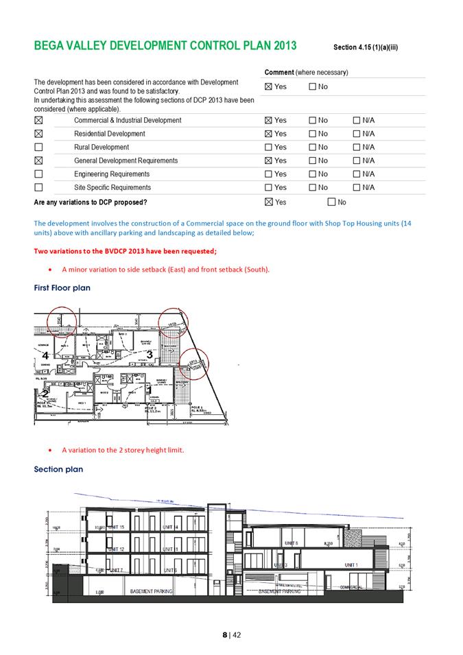
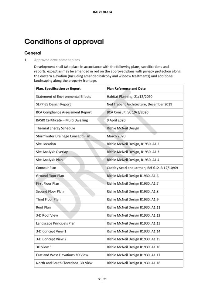
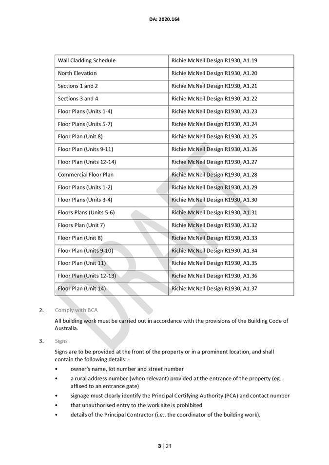
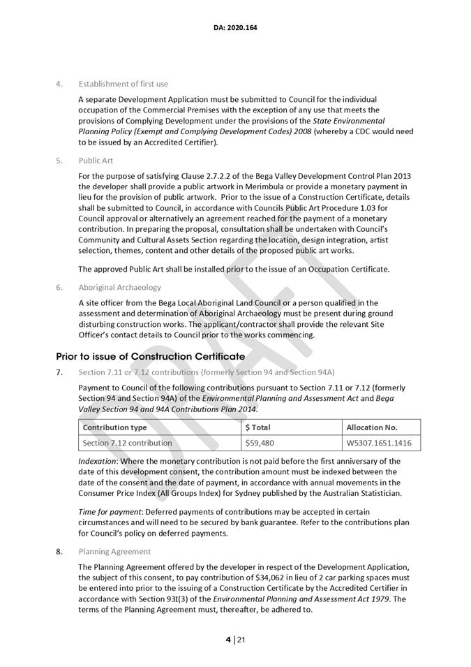
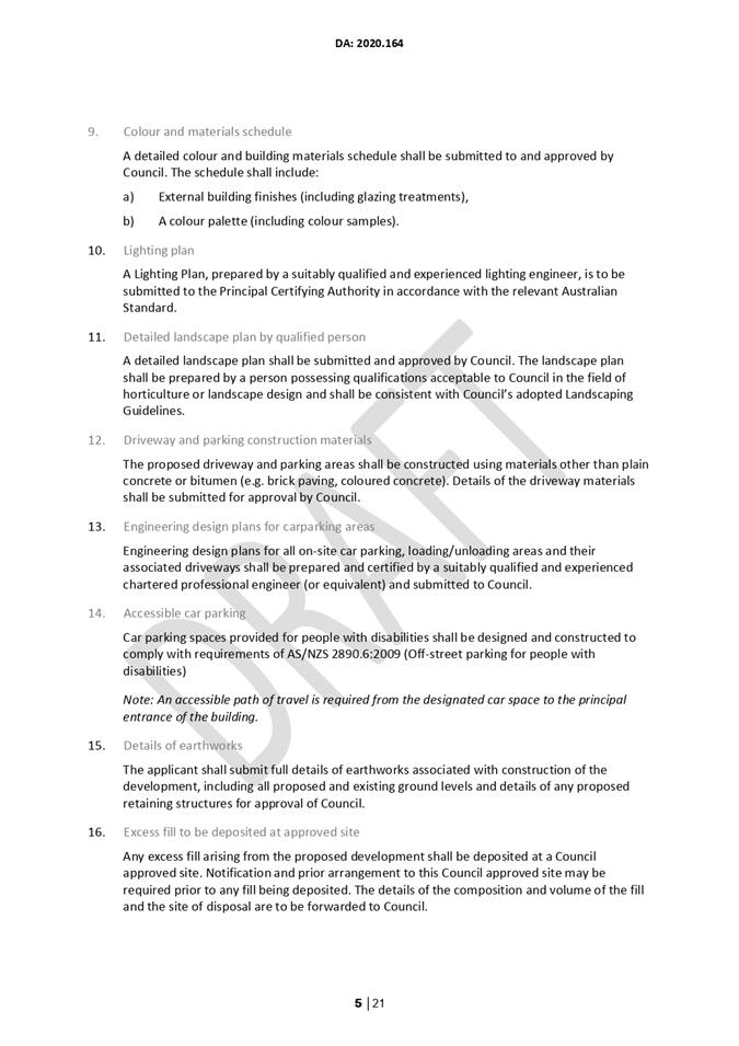
8.3 2020.164 Mixed Use Development - Commercial Premises and Shop Top Housing (14 Units), Lot 52 DP 16678 21 Beach Street, Merimbula.................................................................................. 36
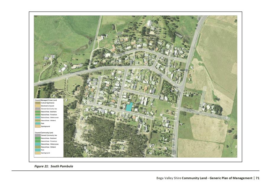
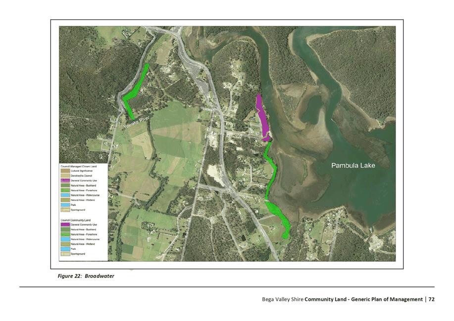
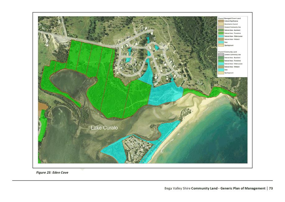
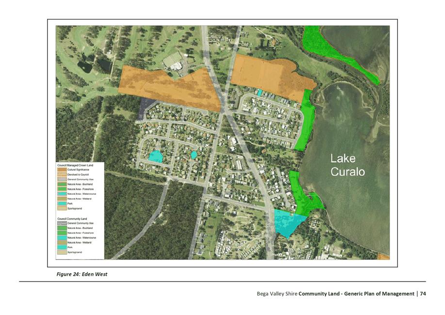
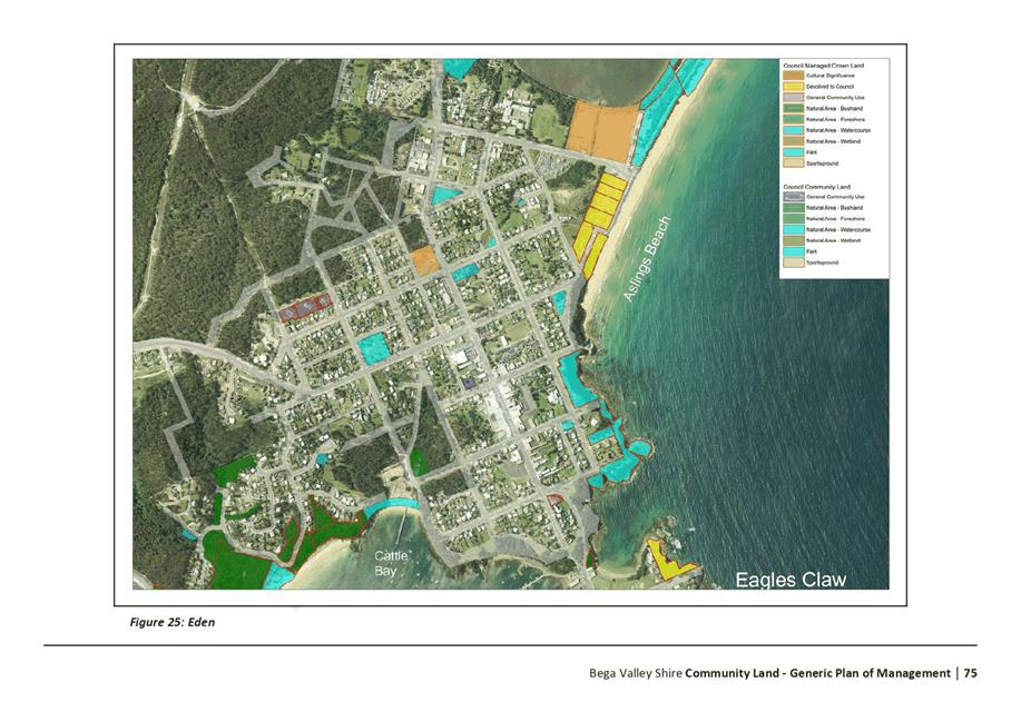
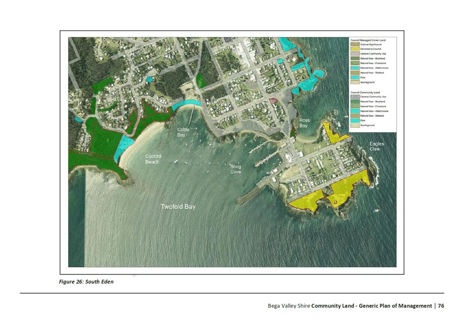
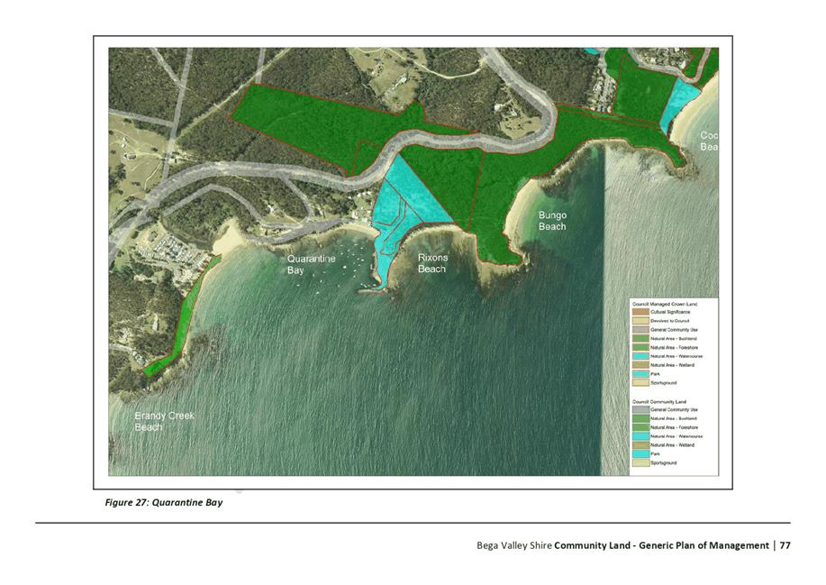
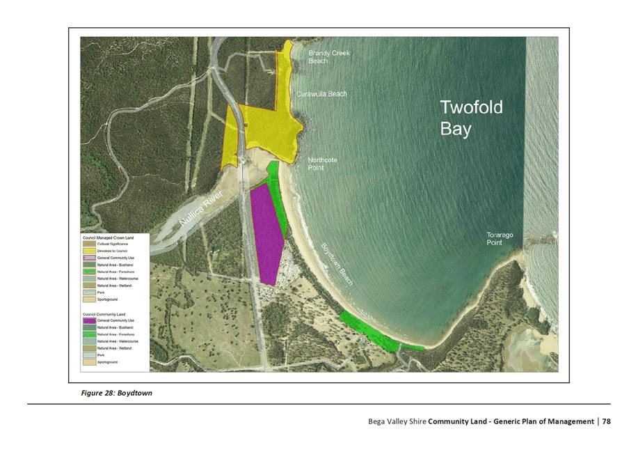
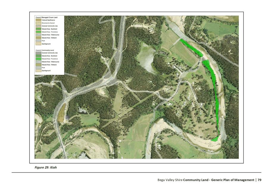
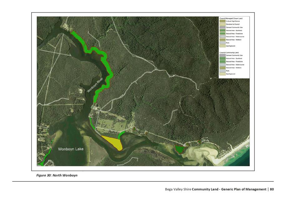
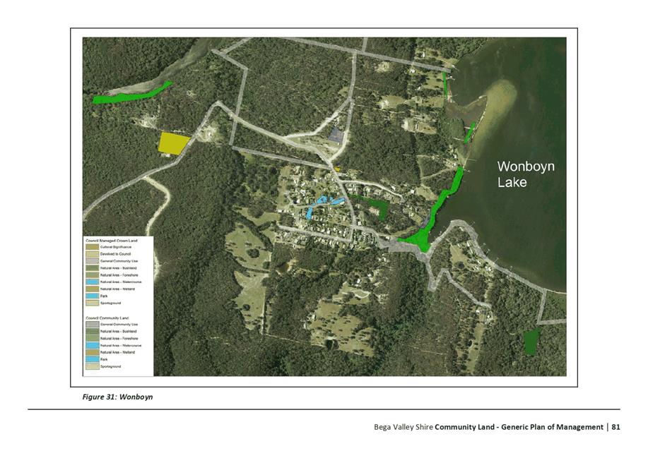
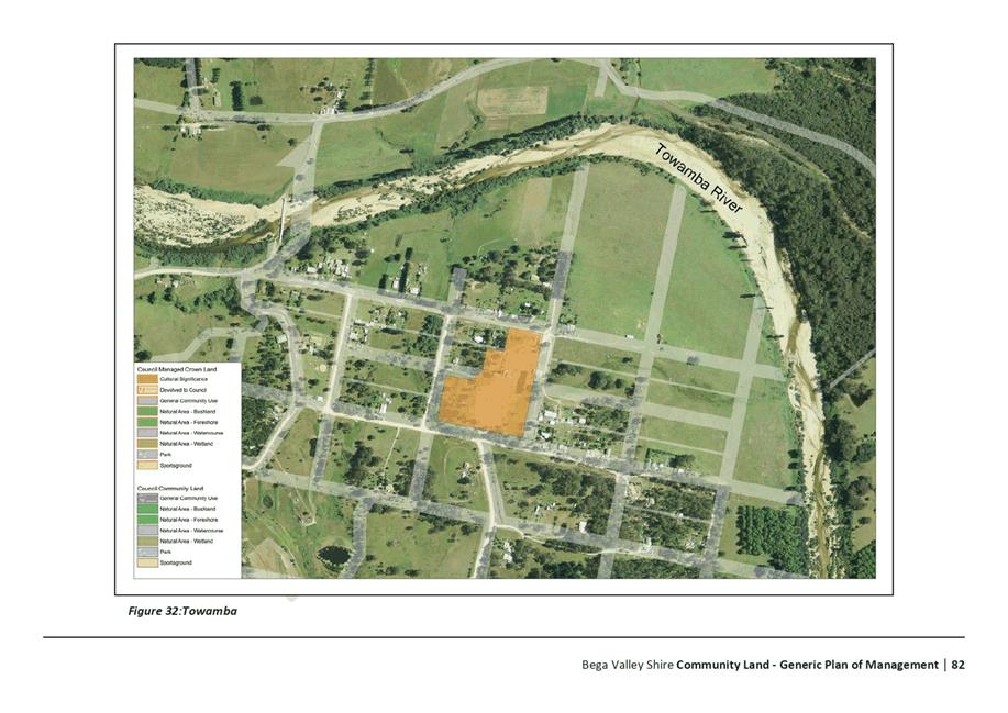
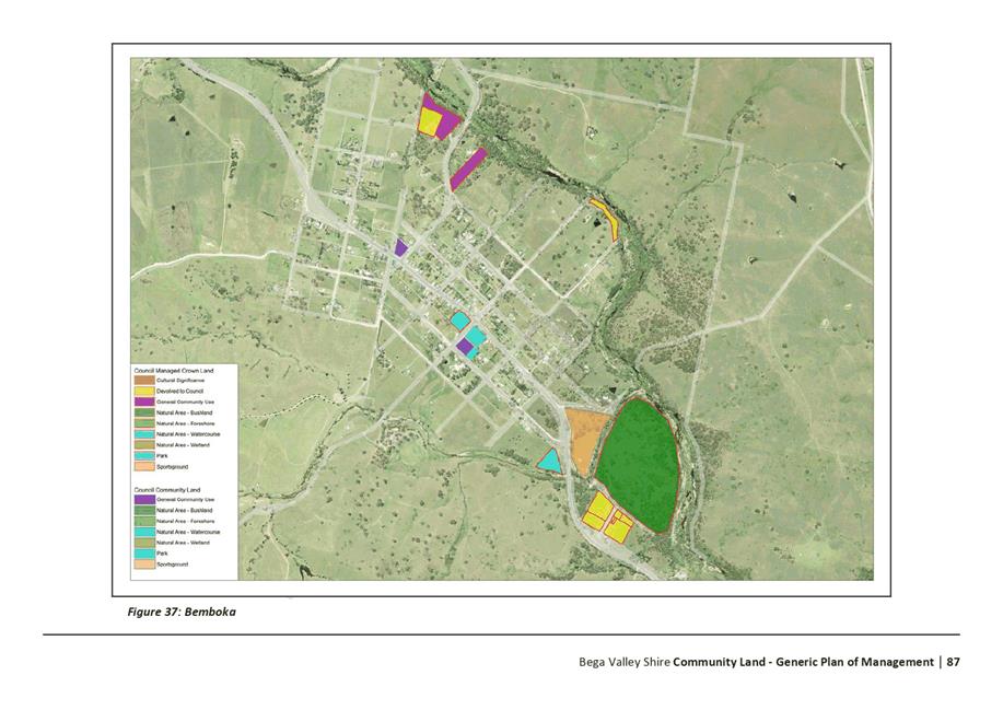
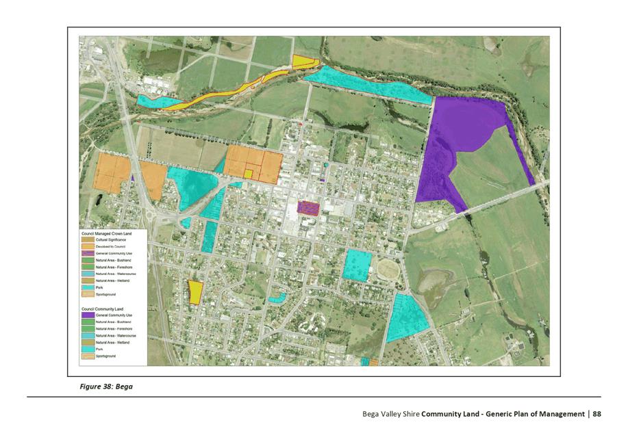
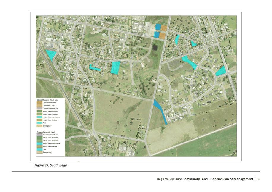
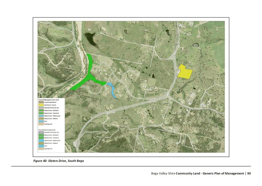
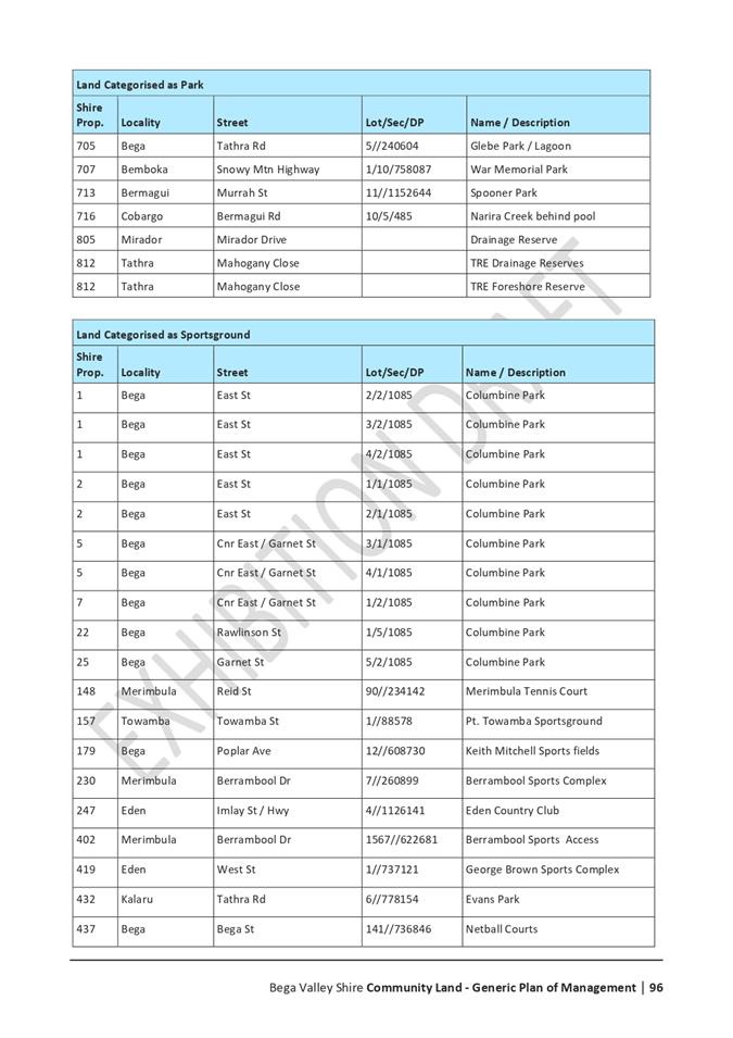
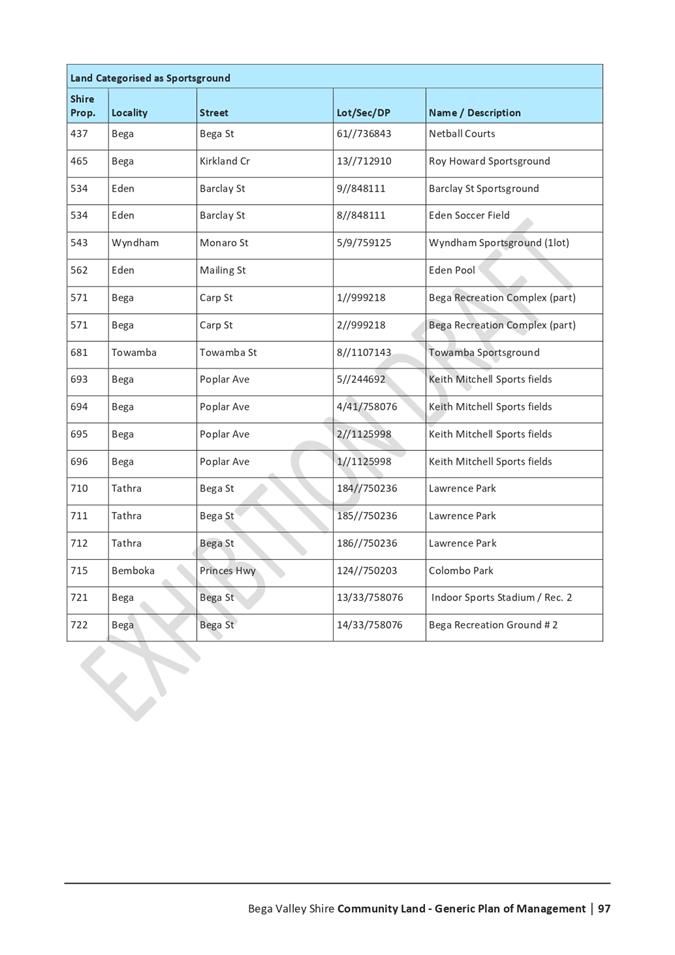
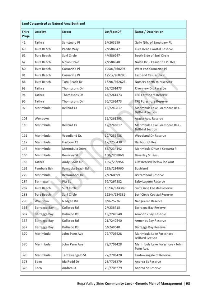
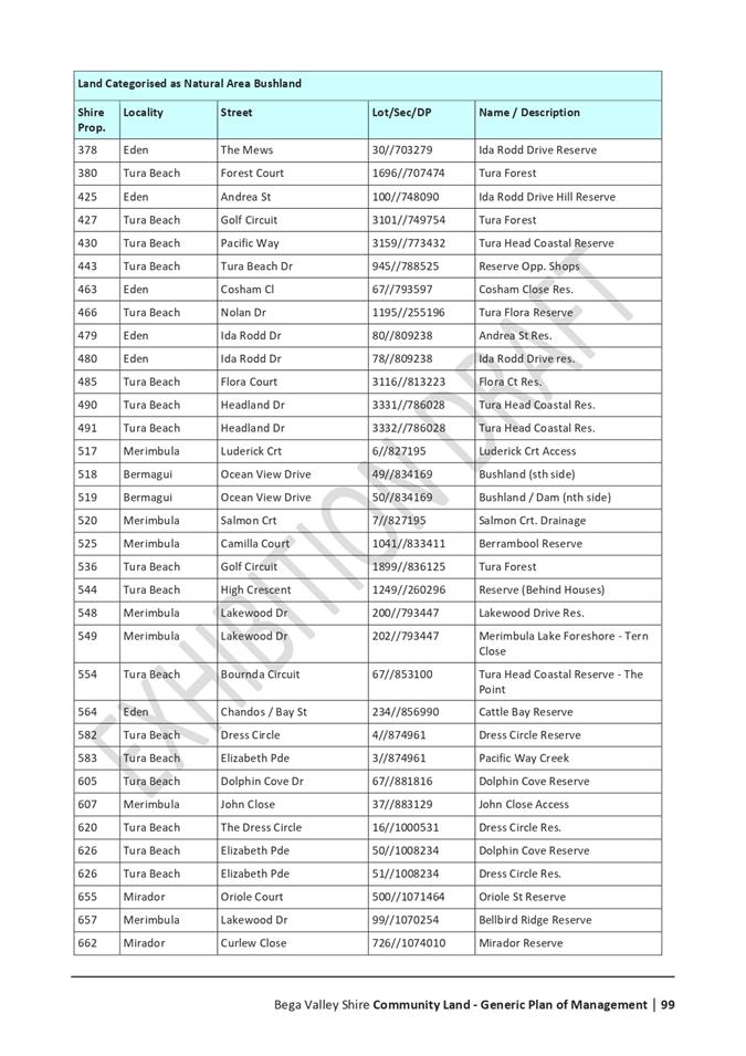
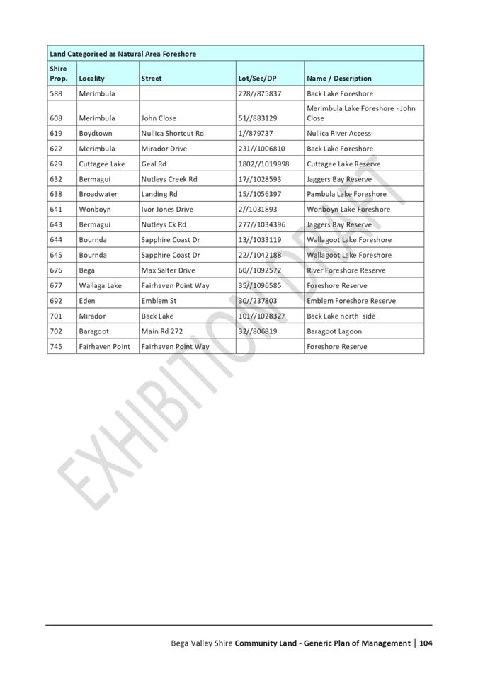
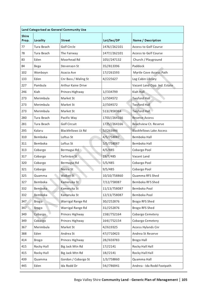
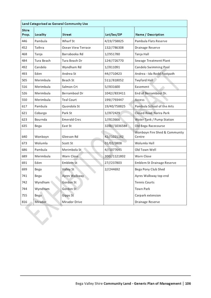
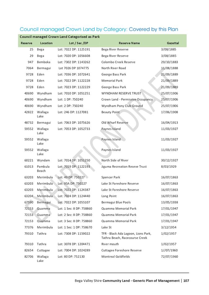
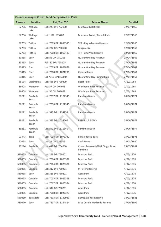
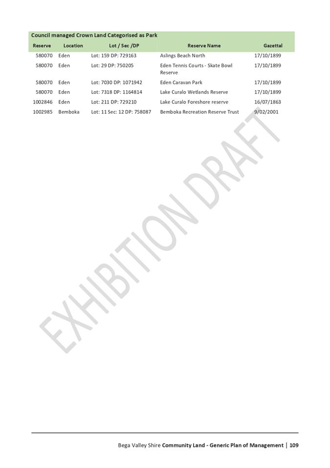
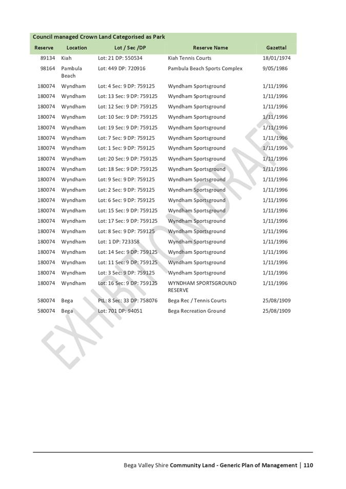
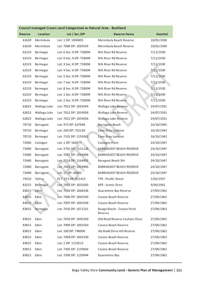
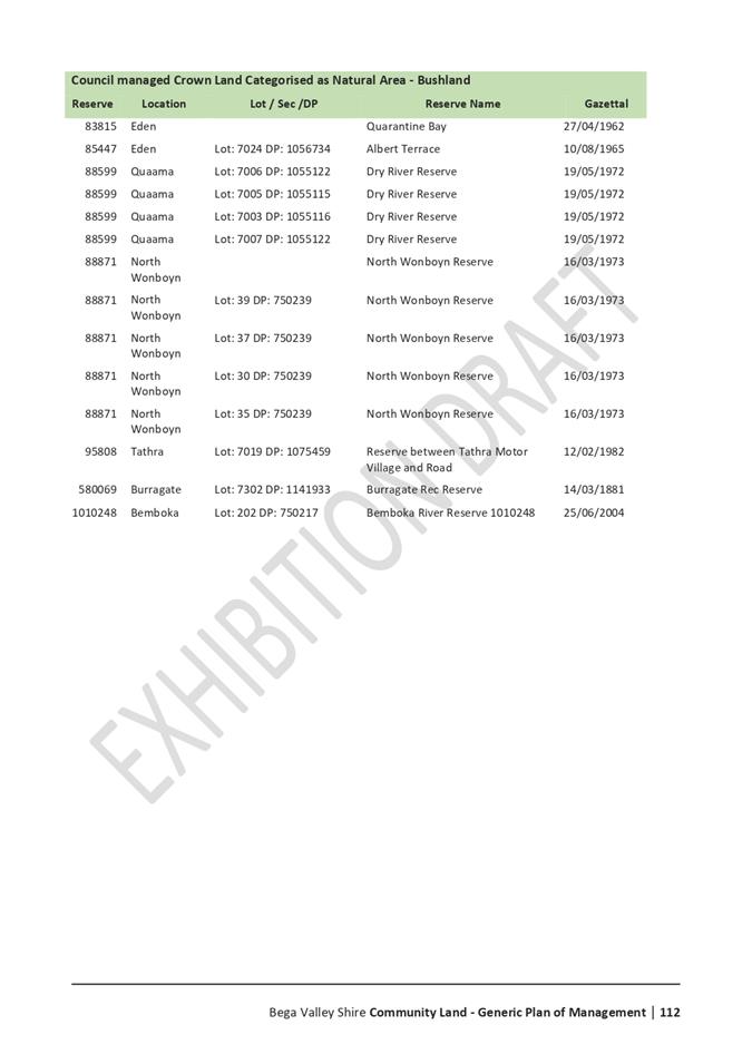
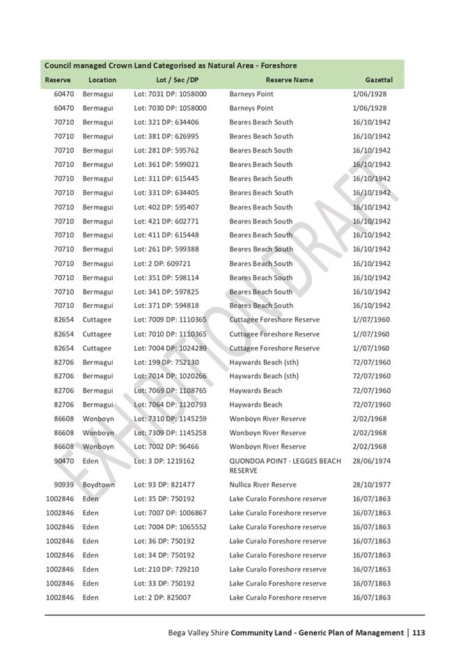
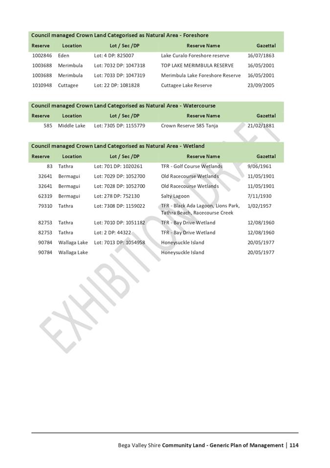
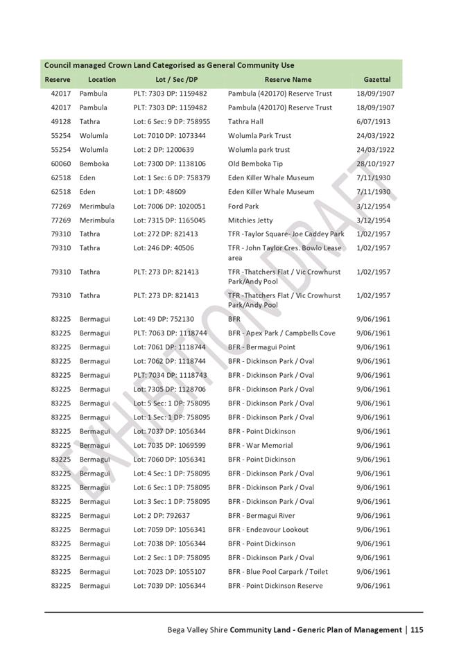
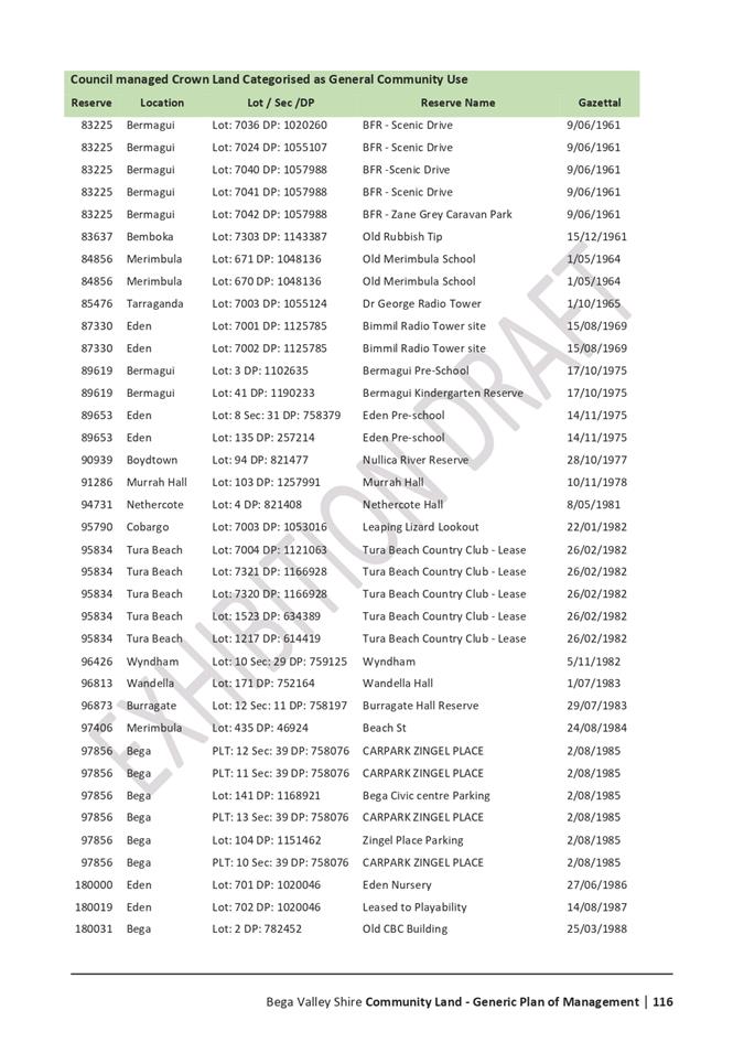
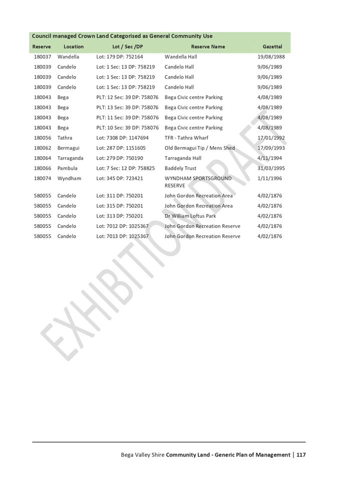
8.4 Public Exhibition of Draft Community Lands Generic Plan of Management.................... 177
8.5 Dual Naming Proposal - Mumbulla Mountain........................................................................ 303
Nil Reports
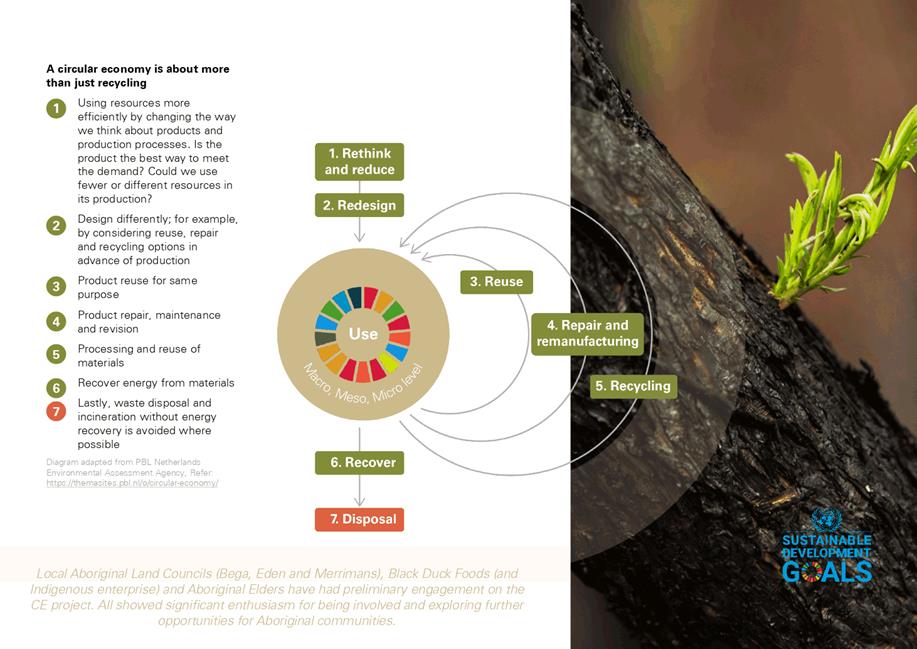
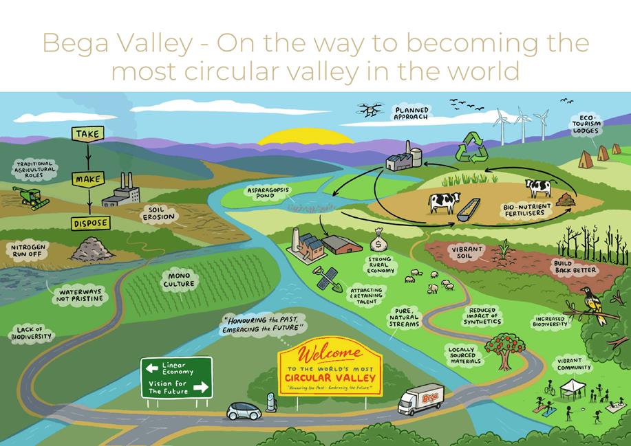
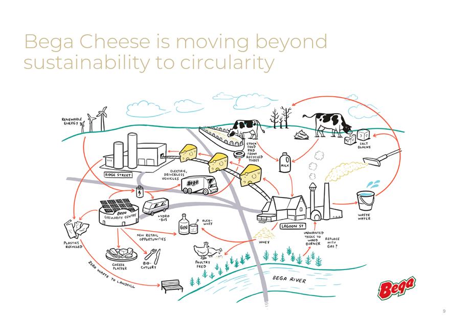
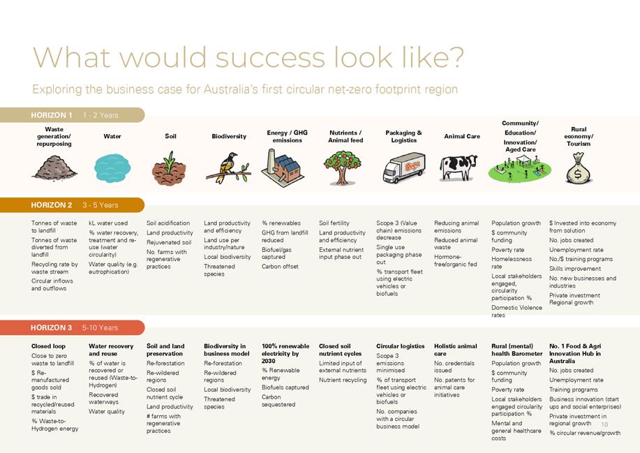
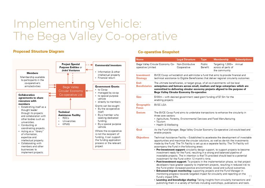
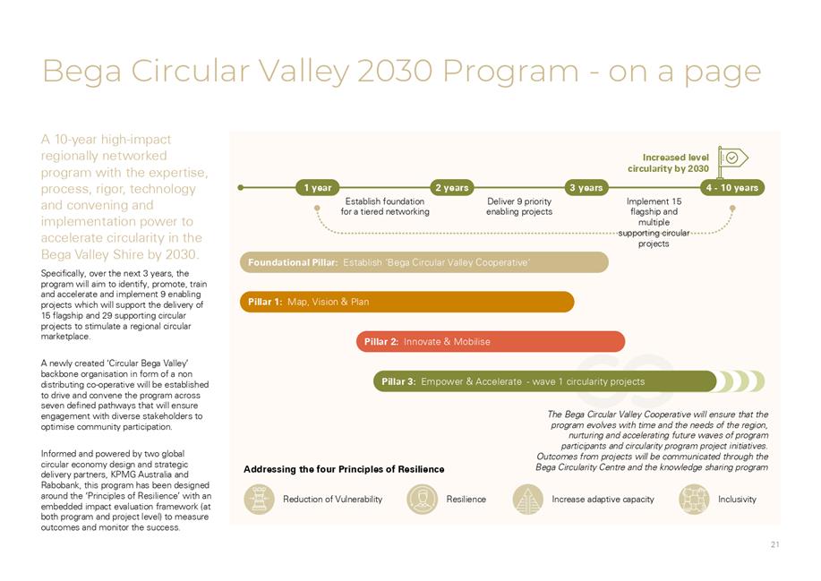
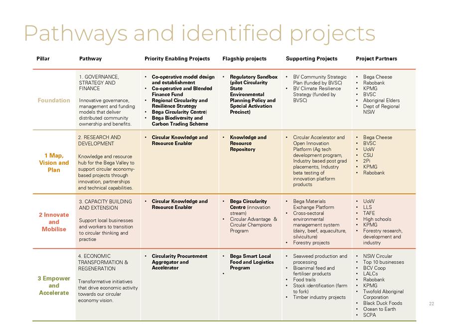
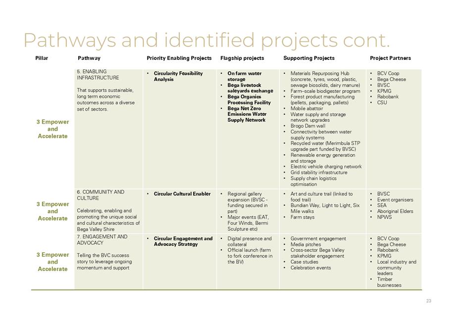
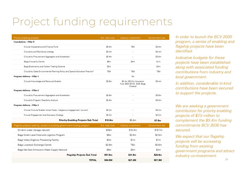
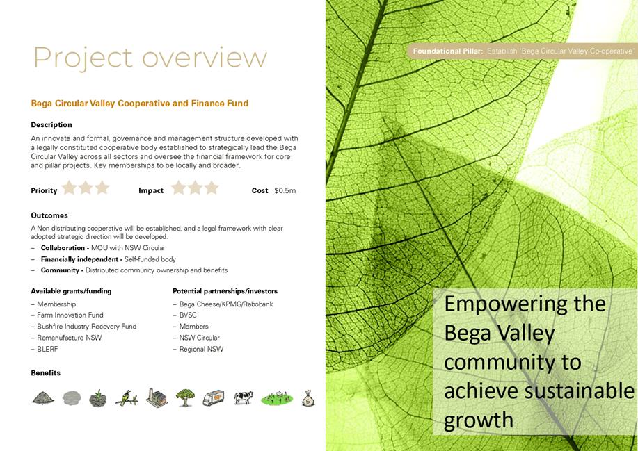
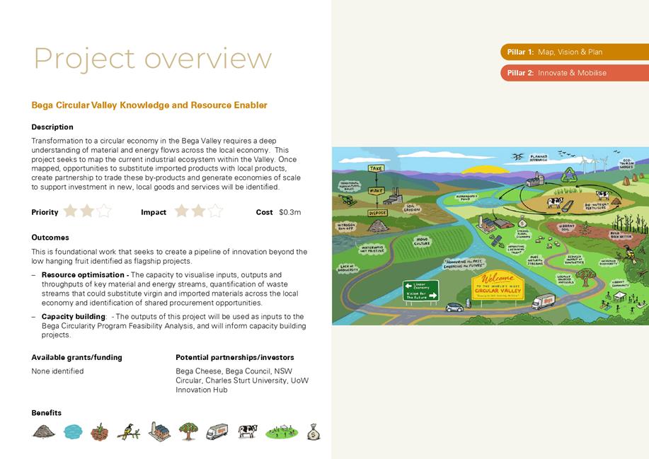
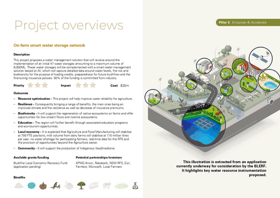
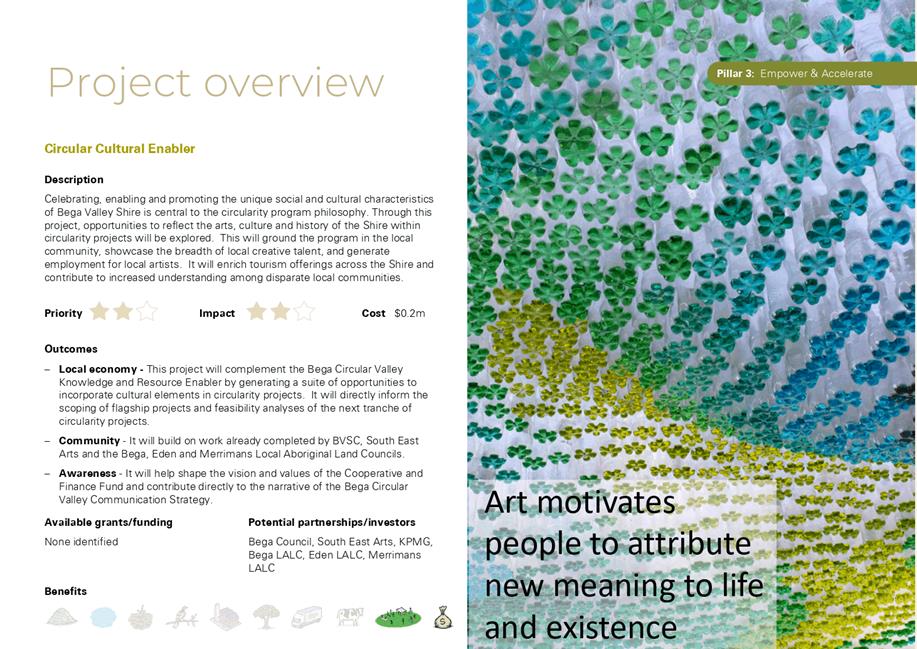
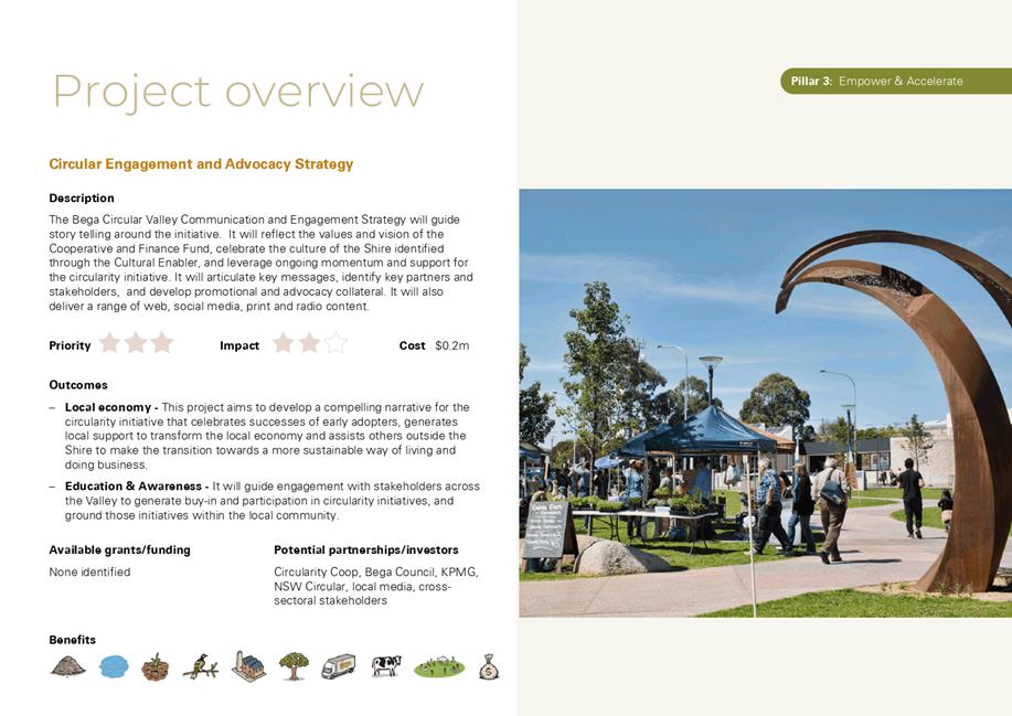
10.1 Involvement in Bega Circular Valley Initiative........................................................................ 308
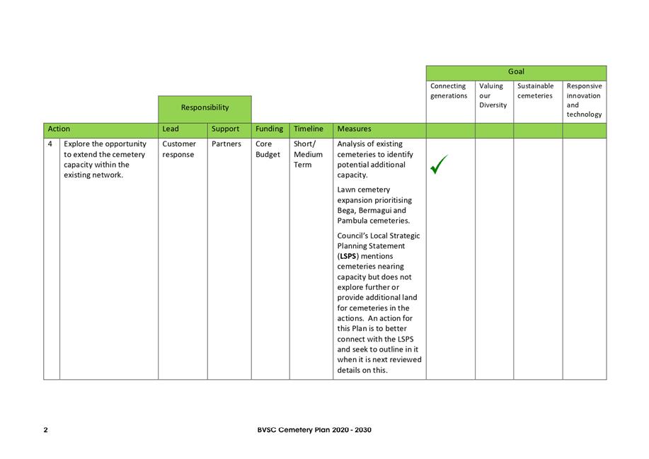
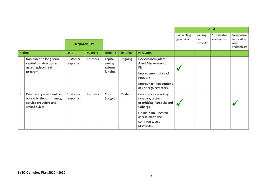
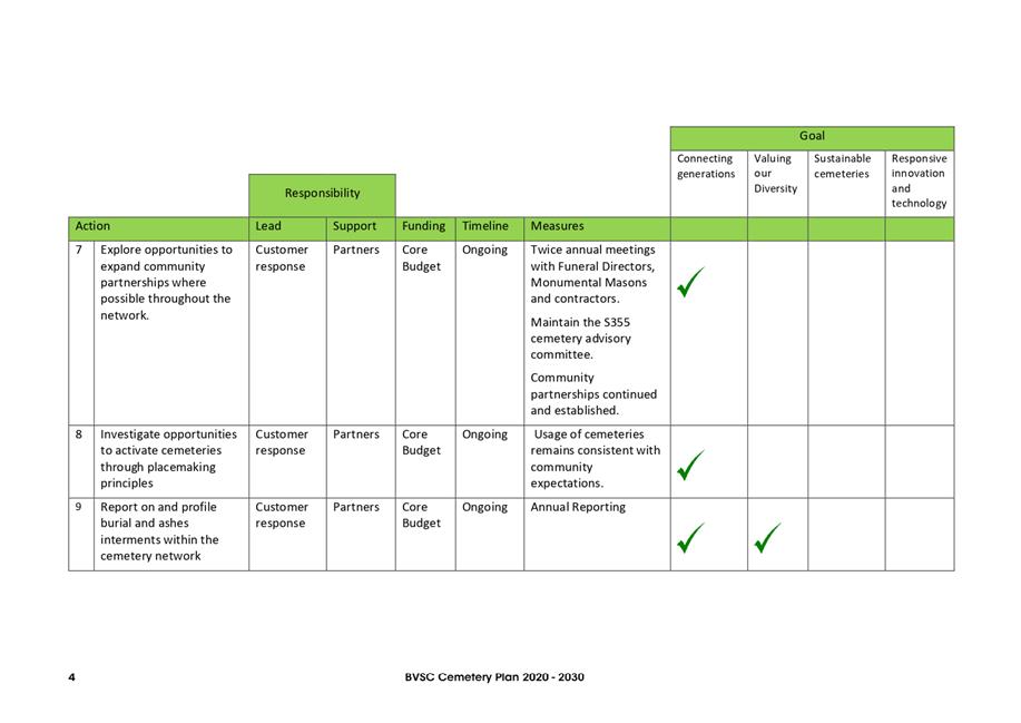
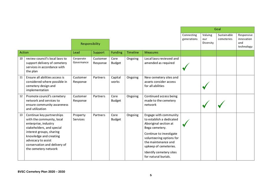
11.1 Outcome of the exhibition of the Cemetery Plan 2020 - 2030............................................ 358
11.2 RFT 2021-93, Barclay Street, Eden Sportsground Pavilion................................................... 437
11.3 Road closure - Barclay Street, Eden sports precinct.............................................................. 444
11.4 RFT 2021-20 Equipment Hire (Plant & Trucks) Panel............................................................ 456
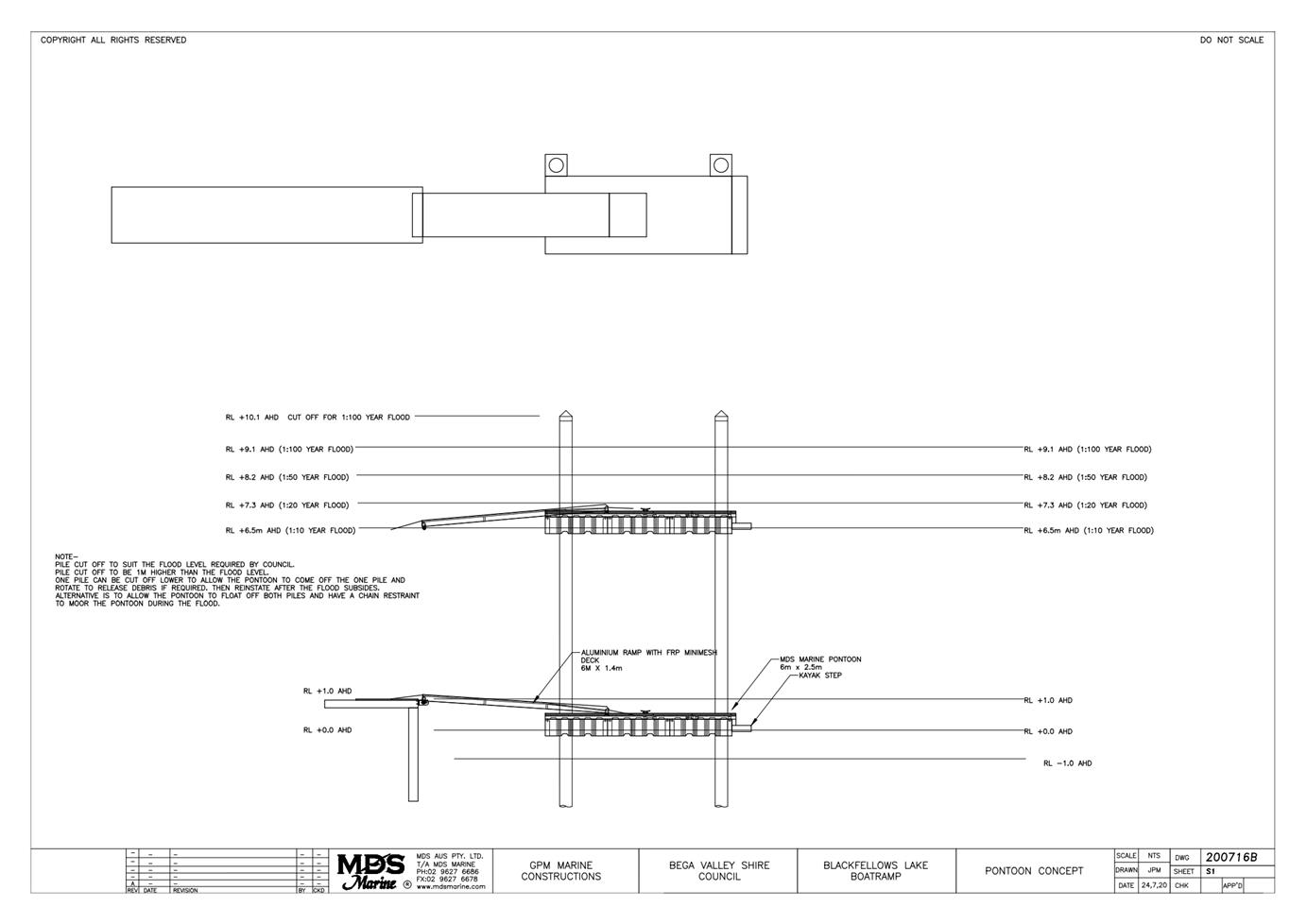
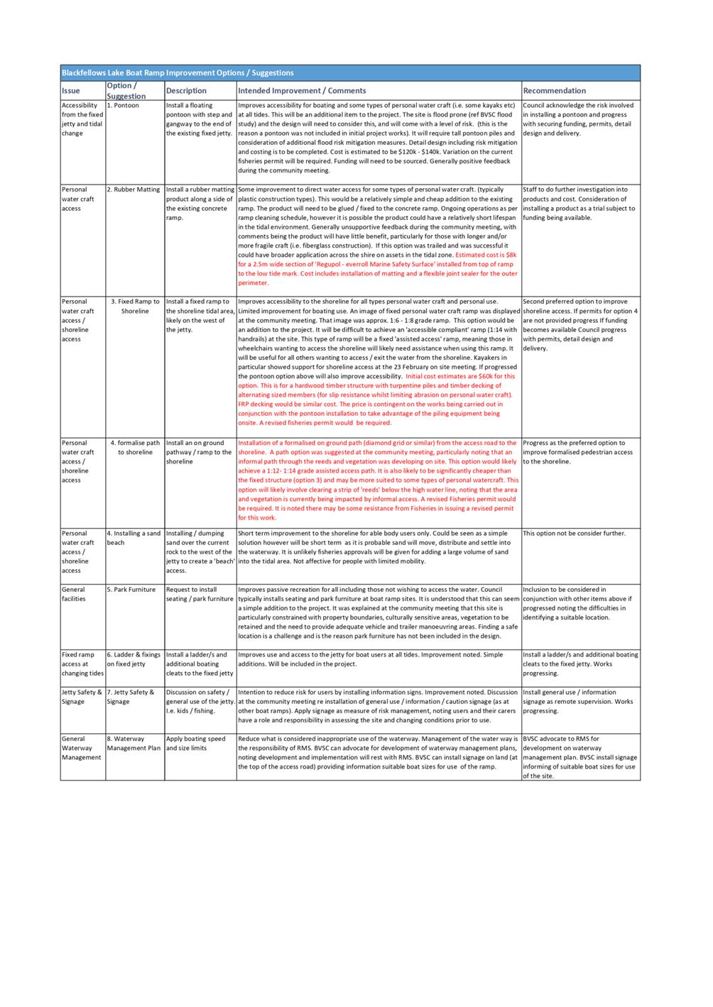
11.5 Blackfellows Lake Boat Ramp.................................................................................................... 459
11.6 Bega Valley Local Traffic Committee........................................................................................ 469
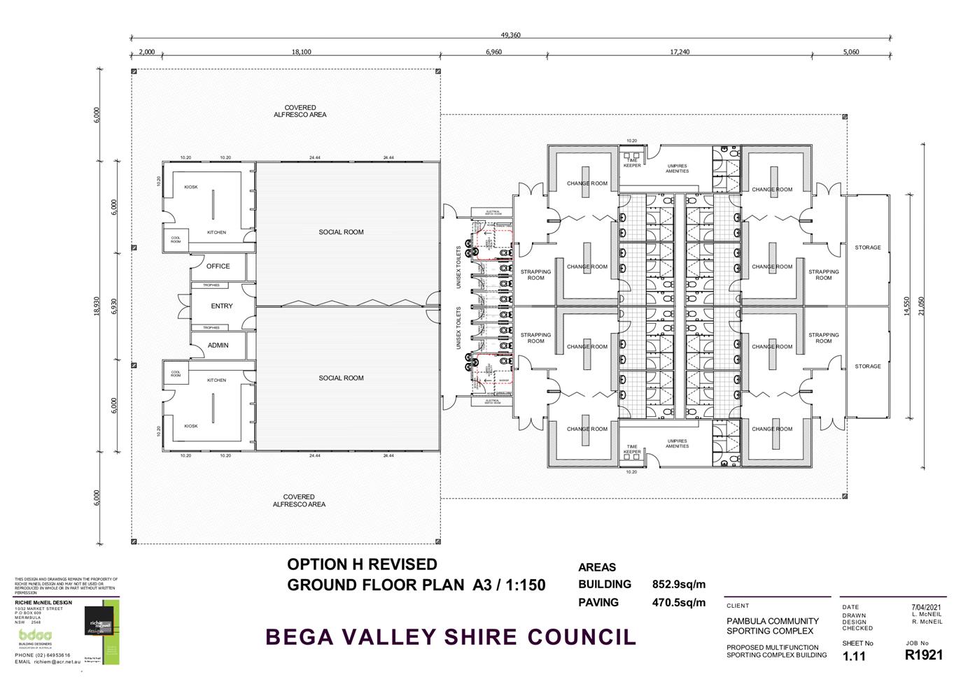
11.7 Pambula Sporting Complex Pavilion Concept Design............................................................ 471
12.1 Remote Attendance by Councillors at Council Meetings..................................................... 480
13.1 Certificate of Investment............................................................................................................ 494
16.1 Naming of Bridge Road............................................................................................................... 500
17.1 Cr Allen - Water Concerns – Brogo Supply.............................................................................. 502
17.2 Cr Allen - Water Concerns - Water Treatment Plant............................................................. 503
Representations by members of the public regarding closure of part of meeting
Adjournment Into Closed Session, exclusion of the media and public........................... 503
|
Council |
21 April 2021 |
Mayoral Minutes
21 April 2021
6.1 Advocacy for disaster resilient highways in the Bega Valley Shire....................... 9
|
Council 21 April 2021 |
Item 6.1 |
Cr Fitzpatrick
That Council:
1. Write to the NSW Minster for Transport requesting an urgent meeting to discuss the Princes Highway and Snowy Mountains Highway and the need to upgrade these key routes to reduce natural disaster-related transport impacts.
2. Write to the Deputy Prime Minister and Minister for Infrastructure, Transport and Regional Development requesting an urgent meeting to discuss recognition of the Princes Highway as a Road of Strategic Importance for freight, disaster resilience and tourism.
3. Request that SEATS and the Canberra Region Joint Organisation also include this in their priority listings for presentations to Government.
4. write to the Minister Littleproud requesting that the most recent flood event classification be escalated to allow for additional funding to those areas impacted.
The Princes Highway and Snowy Mountains Highway are key transport routes through the Bega Valley Shire. During the March 2021 flood event in the Bega Valley, both the Princes Highway and Snowy Mountains Highway were closed. The Princes Highway was closed at Eden and Pambula due to floodwaters, while the Snowy Mountains Highway was closed on Brown Mountain due to a landslip. Both were also closed for significant periods during the 2020 Black Summer Bushfires.
The Princes Highway is an important transport corridor for the southeast of Australia. The need to improve the condition of this corridor between Nowra and the Victorian border has been recognised by the NSW Government, with planned investment of $15 billion over the next 20 years. While this investment is welcome and will provide much needed safety improvements and economic stimulus, urgent upgrade of the two flood-prone sections of the highway in Bega Valley Shire is required.
The Princes Highway from Wollongong to Sale must be immediately included in the Australian Government’s Roads of Strategic Importance (ROSI) initiative, which aims to
improve productivity and efficiency on Australia’s key freight roads, providing better connections between agricultural regions and ports, airports and other transport hubs and better access for tourism, mining and other sectors. Recognition of this stretch of the Princes Highway as a key link in the National Highway (part of the National Land Transport Network is critical for freight, disaster resilience and tourism. Inclusion in this major network of highways and motorways connecting Australia's capital cities and major regional centres would reflect the importance of this transport corridor and assist the NSW Government to fund both short-term flood mitigation works and the planned longer-term duplication.
The Snowy Mountains Highway is the key east-west corridor from the Bega Valley. The Brown Mountain stretch of this highway is a significant barrier to freight movement, due to its narrow, winding configuration. It is also prone to landslip during heavy rainfall, with two closures in the last 14 months. Recognition of the Snowy Mountains Highway as a ROSI would similarly assist the NSW Government to fund its upgrade. The Snowy Mountains Highway will now face continued, intermittent closures while works are carried out however these are likely to make the road resilient into the future without significant additional funding commitments.
These two road corridors are critical to the food and energy security of the Bega Valley and warrant the urgent attention of the NSW and Australian Governments.
Nil
Council |
21 April 2021 |
8.1 Submission on proposed planning amendments to support agritourism and small-scale agriculture development..................................................................................... 12
8.2 Finalisation of Secondary Dwellings and Dual Occupancies in Rural Zones Planning Proposal............................................................................................................................. 28
8.3 2020.164 Mixed Use Development - Commercial Premises and Shop Top Housing (14 Units), Lot 52 DP 16678 21 Beach Street, Merimbula........................................ 36
8.4 Public Exhibition of Draft Community Lands Generic Plan of Management.... 177
8.5 Dual Naming Proposal - Mumbulla Mountain.................................................. 303
|
Council 21 April 2021 |
Item 8.1 |
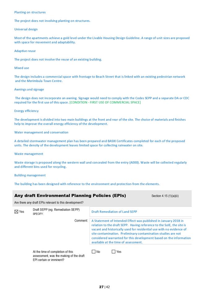
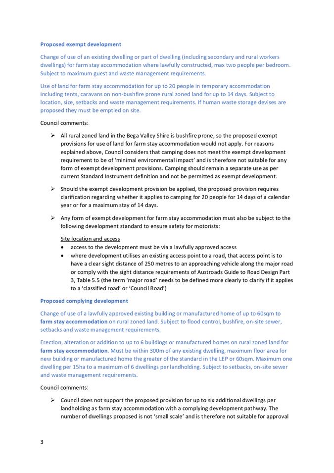
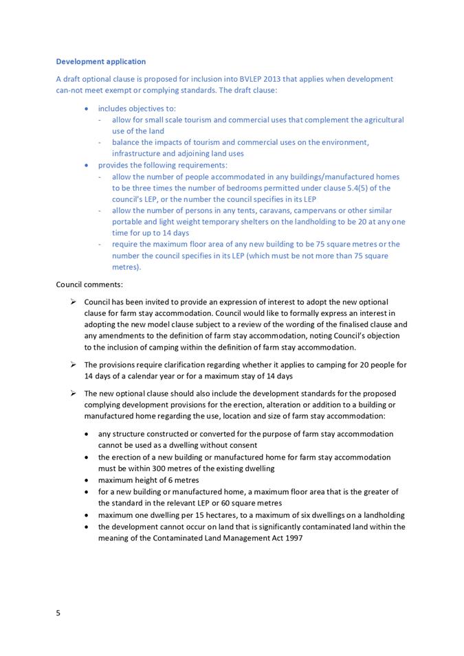
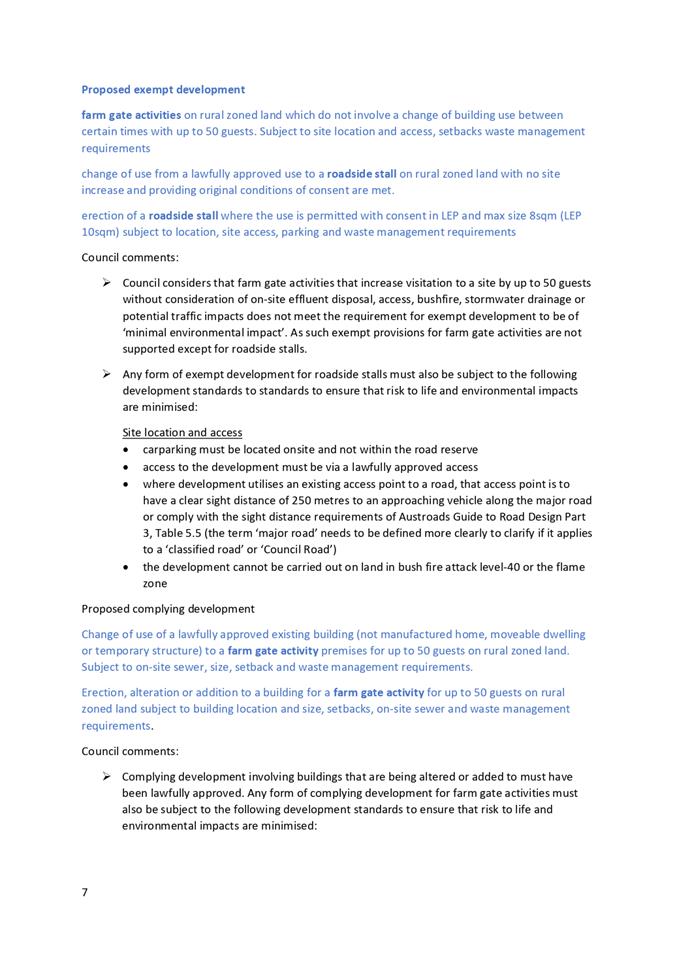
Council has been invited to make a formal submission to the Explanation of Intended Effect: Agritourism and small-scale agriculture development formulated by the NSW Department of Planning, Industry and Environment.
Director Community Environment and Planning
That Council:
1. Provide a formal submission (Attachment 1) to the NSW Department of Planning, Industry and Environment on the Explanation of Intended Effect: Agritourism and small-scale agriculture development.
2. Formally express an interest in adopting the proposed new model clauses, subject to resolution to the satisfaction of staff of the qualifications identified in Attachment 1.
Executive Summary
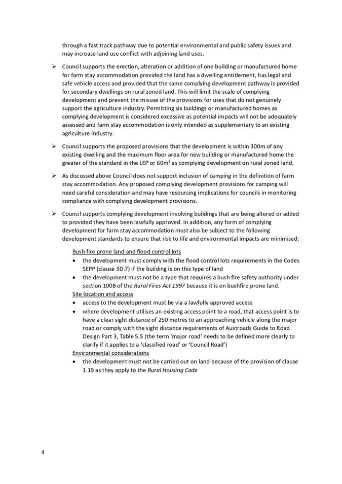
This report recommends that Bega Valley Shire Council make a formal submission to DPIE on the detail of the EIE and advise that it wishes to express an interest in adopting the new optional clauses for farm stay accommodation and farm gate activities into Bega Valley Local Environmental Plan 2013 (BVLEP 2013).
Background
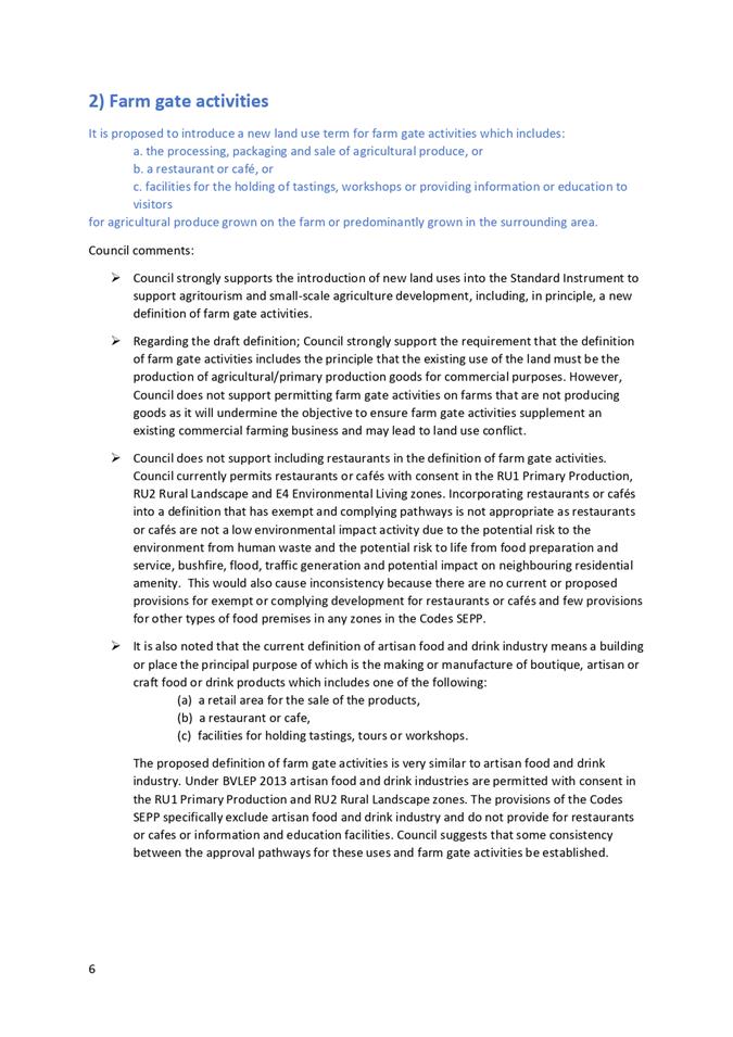
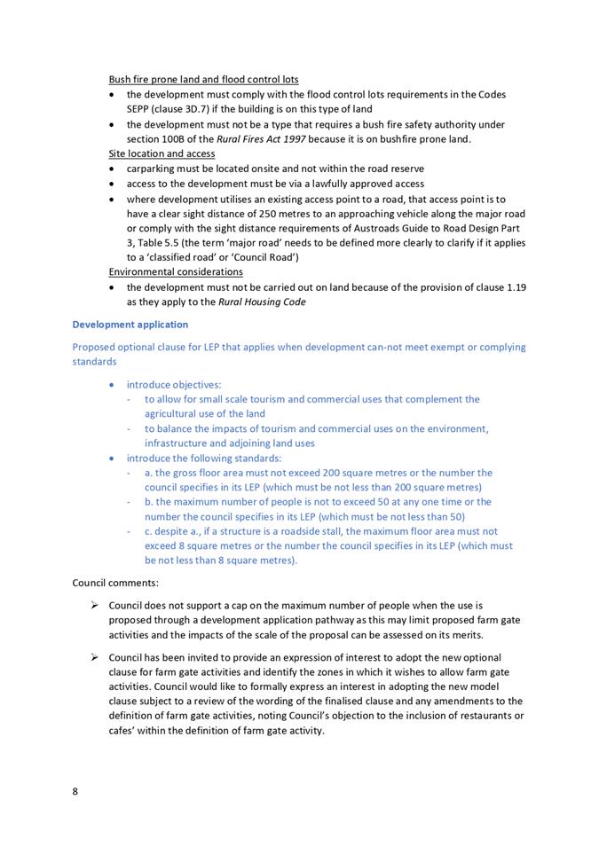
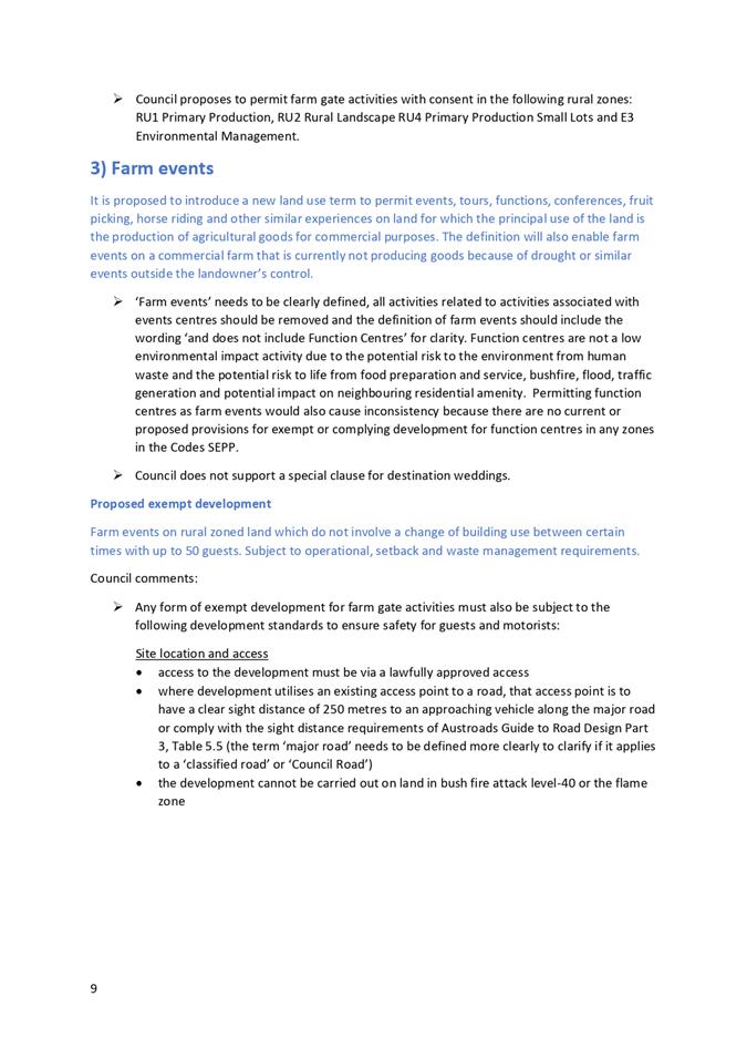
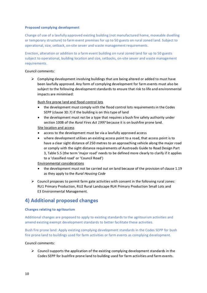
The EIE includes amendments to various planning instruments that will enable opportunities for farm businesses in the Bega Valley Shire to diversify and thrive. These changes include new land use definitions to enable the agritourism uses of farm events and farm gate activities, as well as an amendment to the definition of farm stay accommodation. It also proposes alternative pathways for the approval of agritourism development or activities with low environmental impacts.
Other amendments in the EIE include changes to State Environmental Planning Policy (Exempt and Complying Development Codes) (Codes SEPP) to facilitate rebuilding of farm infrastructure following natural disasters and amendments to existing exempt and complying development standards for uses including stock containment lots, small-scale processing plants, biosecurity, farm dams, rural dwelling setbacks and recreational beekeeping.
The proposed submission (Attachment 1) is generally supportive of the NSW Government’s initiatives to enable farmers to meet new market trends and value add to the agriculture industry. These initiatives align with Council’s goals to ensure planning controls enable a diversified and productive agricultural sector, new agricultural industries and agricultural education facilities, as well as encouraging fast track development approval pathways for appropriate development.
The proposed submission details support for elements of the various amendments proposed, provides comments regarding the detail of the approval pathways proposed to ensure the potential impacts of development are appropriately considered and suggests changes to increase the effectiveness of the provisions. The proposed submission includes several suggestions relating to the draft definitions and proposed exempt and complying pathways to ensure that the potential impacts to the environment and community are considered adequately and that farmers’ right to farm is not adversely affected by land use conflict with adjacent agritourism uses.
Options
Options available to Council are to:
1. Adopt Attachment 1 as Council’s submission on the EIE. This is the recommended option. It identifies amendments to NSW planning instruments that support Council’s adopted strategic land use directions for the agriculture industry in the Bega Valley Shire.
2. Not make a submission. This would mean that changes to NSW planning instruments will be made without Council’s input. These amendments may not align with Council’s adopted strategic direction for the agriculture industry in the Bega Valley Shire.
3. Amend the proposed submission. Councillors would need to advise staff of proposed amendments.
Community and Stakeholder Engagement
Engagement undertaken
Council staff have not yet provided any input into the proposed changes outlined in the EIE to date.
Engagement planned
Should Council resolve to make a submission, Council staff will engage with DPIE in relation to the current agritourism initiative and resolution of the wording of the proposed model clauses.
Financial and Resource Considerations
There is no cost to Council, other than staff time to participate in drafting the submission and reporting the matter to Council.
Legal /Policy
The EIE will result in amendments to State Environmental Planning Policy (Primary Production and Rural Development) 2019, the Codes SEPP and the Standard Instrument (Local Environmental Plans) Order 2006. It could result in several changes to BVLEP 2013 and the application of current exempt and complying provisions under the Codes SEPP within the Shire.
Impacts on Strategic/Operational/Asset Management Plan/Risk
Strategic Alignment
The proposed submission to the EIE is aligned with the Bega Valley Community Strategic Plan 2040, the Bega Valley Shire Local Strategic Planning Statement and the Sapphire Coast Vision and Platform for Growth. It is also strategically aligned with the South East and Tablelands Regional Plan 2036 and the Far South Coast Regional Economic Development Strategy 2018-2022.
Environment and Climate Change
The EIE could support the Shire’s agriculture industry to become more resilient and adapt to impacts, including environment and climate change impacts by facilitating diversification.
Economic
The amendments detailed in the EIE have the potential to have a positive economic impact in the Shire through supporting business diversification on farms and value adding to both the agriculture and tourism industries.
Risk
There are no material risks to Council of providing comment on the EIE. The proposed submission to the EIE includes suggestions to mitigate any additional risk to people or the environment.
Social / Cultural
The amendments detailed in the EIE have the potential to provide new opportunities for agriculture land uses to support and enhance the agriculture industry. This is likely to have positive social benefits to the local community involved directly or indirectly with the agriculture industry in the Bega Valley Shire.
1⇩. Proposed submission to Explanation of Intended Effect: Agritourism and small-scale agriculture development
|
Council |
21 April 2021 |
|
Item 8.1 - Attachment 1 |
Proposed submission to Explanation of Intended Effect: Agritourism and small-scale agriculture development |
|
Item 8.2 |
8.2. Finalisation of Secondary Dwellings and Dual Occupancies in Rural Zones Planning Proposal
A planning proposal to amend the Bega Valley Local Environmental Plan 2013 has been exhibited to implement the Bega Valley Shire Local Strategic Planning Statement 2040 and Rural Residential Strategy. This report seeks Council’s resolution to finalise the planning proposal subject to changes arising through the public exhibition process.
Director Community Environment and Planning
That Council:
1. Finalise amendments to Bega Valley Local Environmental Plan 2013 (Amendment 36) subject to the revisions detailed in Attachment 1 and in accordance with the delegations issued by the Minister for Planning and Public Spaces under Section 3.36 of the Environmental Planning and Assessment Act 1979.
2. Provide formal confirmation to the Department of Planning, Industry and Environment that it wishes to incorporate Clause 5.5 ‘Controls relating to secondary dwellings on land in a rural zone’ into Bega Valley Local Environmental Plan 2013 as detailed in Attachment 1.
3. Officers inform those who made a submission during exhibition of the Planning Proposal of Council’s resolution on this matter.
Executive Summary
The planning proposal to amend Bega Valley Local Environmental Plan 2013 (BVLEP 2013) to include secondary dwellings as a land use that is permitted with consent in rural zones, and to increase the distance that two dwellings in a rural zone may be situated from each other from 100m to 250m has been exhibited. Public exhibition took place between 26 Jan 2021 and 23 February 2021. Three public and three agency submissions were received to the exhibition.
The purpose of this report is to advise Council of the feedback received during exhibition of the planning proposal and seek a resolution to finalise the matter. Two changes to the amendment to BVLEP 2013 as detailed in the exhibited planning proposal are recommended in response to an agency’s objections and another change is recommended following a recent amendment to the Standard Instrument Principal Local Environmental Plan, which introduced a new optional clause that applies to secondary dwellings in rural areas.
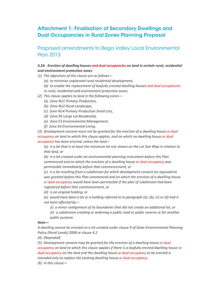
Details of the recommended amendments to Clauses 4.2A, 4.2D and 5.5 of BVLEP 2013 are included in Attachment 1.
Background
Council officers prepared a planning proposal to implement recommendations of Bega Valley Shire Local Strategic Planning Statement 2040 and Bega Valley Shire Rural Residential Strategy. The aim of the planning proposal is to amend BVLEP 2013 to:
1. Increase the provision of affordable housing options for farmers and other landowners in the rural zones, without permitting further subdivision of land, by including secondary dwellings as a land use that is permitted with consent, and
2. Continue to limit the impact of additional dwellings in the rural zones on agricultural resources, farming operations, landscape amenity and Council roads, but introduce greater flexibility to permit optimal siting of dwellings by increasing the distance that two dwellings in a rural zone may be situated from each other from 100m to 250m to better respond to the topographical and other constraints of rural land in the Bega Valley Shire.
In accordance with the Council resolution of 7 October 2020 the Planning Proposal was forwarded to the Department of Planning Infrastructure and Environment seeking Gateway approval.
The Gateway Determination also required the planning proposal to include dual occupancy development in clause 4.2A of the BVLEP 2013.
Options
Council can proceed to finalise the matter under delegation where amendments are made to the exhibited planning proposal in response to the objections by the NSW Department of Primary Industries. This is the recommended option.
If Council chooses not to amend the exhibited planning proposal in accordance with the requirements of NSW Department of Primary Industries Agriculture submission, Council will not have delegation to finalise the amendment and the matter will need to be determined and finalised by a delegate for the Minister for Planning and Public Spaces.
Community and Stakeholder Engagement
Engagement undertaken
Consultation was conducted in accordance with the requirements of the Gateway Determination and Council’s adopted Community Engagement Strategy. The public exhibition was undertaken for 28 days from 26 Jan 2021 to 23 February 2021. Exhibition of the planning proposal was notified on the ‘Have Your Say’ page of Council’s website and the development professionals group was notified directly by email.
In accordance with the Gateway Determination, consultation with the NSW Biodiversity and Conservation Division, NSW Department of Primary Industries and NSW Rural Fire Service was also undertaken.
Summary of submissions
Three agency submissions and three public submissions were received during the exhibition period. The three public submissions were from members of the development professionals group. A summary of the key issues raised in each of the submissions received are detailed below including discussion from Council staff regarding recommendations for amendments to the planning proposal.
1) Bushfire Fire
Issue summary: NSW Rural Fire Service reviewed the proposal and had no objections subject to a requirement that the future development presenting an increase in residential density complies with Chapter 7 and clause 8.2.1 of Planning for Bush Fire Protection 2019.
Staff comment: Chapter 7 and clause 8.2.1 of Planning for Bush Fire Protection 2019 cover requirements for residential infill development and increased residential densities respectively. Compliance with Planning for Bush Fire Protection 2019 is part of the normal development assessment process for any development application for a secondary dwelling on bushfire prone mapped land.
Recommendation: No change to planning proposal.
2) Biodiversity and Conservation
Issue summary: Department of Planning, Industry and Environment Biodiversity Conservation Division reviewed the proposal and had no objections.
Staff comment: Noted
Recommendation: No change to planning proposal.
3) Consideration of prohibition of dual occupancies (detached) in the RU1 and RU2 zones
Issue summary: Department of Primary Industry (DPI) Agriculture reviewed the proposal and had no objection to permitting secondary dwellings with consent in the RU1 and RU2 zones; however did suggest that Council consider prohibiting dual occupancies (detached) in those zones to ensure that additional housing is small scale and retains agriculture as the primary use of suitable rural land.
Staff comment: Detached dual occupancies are already permitted with Council approval in the RU1 Primary Production and RU2 Rural Landscape zones and attached dual occupancies are permitted in the RU1 Primary Production, RU2 Rural Landscape and RU4 Primary Production Small Lots zones. Prohibition of detached dual occupancies is not supported as it would be contrary to the aims of the Rural Residential Strategy and Bega Valley Shire Local Strategic Planning Statement 2040 as it would decrease opportunities to provide affordable housing options and improve housing diversity in rural areas.
Recommendation: No change to planning proposal.
4) Objection to proposal to permit secondary dwellings with consent in the RU4 zone
Issue summary: DPI Agriculture objected to permitting secondary dwellings with consent in the RU4 zone until such time as the review of the RU4 Primary Production Small Lots zone has been completed in accordance with the adopted Rural Residential Strategy 2020.
Staff comment: The exhibited planning proposal included provisions to include secondary dwellings as a use that is permitted with consent in zones RU1 Primary Production, RU2 Rural Landscape and RU4 Primary Production Small Lots. On consideration, the agency objection to the introduction of this form of housing in the RU4 zone at this time is justified as Council has not done the planned strategic work to identify future RU4 zones and as such cannot be confident that this form of housing is appropriate in this zone. It is proposed to revisit this issue following completion of the review of the application of the RU4 zone, including the land that is currently zoned RU4 as per the recommendation of the adopted Rural Residential Strategy 2020.
Recommendation: That Council include secondary dwellings under Clause 4.2D as permissible with consent only in the RU1 Primary Production and RU2 Rural Landscape zones.
5) Objection to proposal to increase the maximum distance between dwellings in rural zones
Issue summary: DPI Agriculture objected to the proposed amendment to increase the maximum distance between dwellings from 100m to 250m in clause 4.2D(2)(c) unless Council amends clause 4.2D(2) of BVLEP 2013 to include a consideration that any secondary dwelling or detached dual occupancy will not have an adverse impact on, or increase the potential for land use conflict with, agricultural production on neighbouring properties.
Staff comment: The amendment required by DPI Agriculture to the existing clause 4.2D is minor and will help ensure that future development that may result from this planning proposal does not have an adverse impact on surrounding farming operations.
Recommendation: That the objective of clause 4.2D(2) (1)(b) is amended from:
‘to ensure development is of a scale and nature that is compatible with the primary production potential, rural character and environmental capabilities of the land’, to:
‘to ensure development is of a scale and nature that is compatible with the primary production potential, rural character and environmental capabilities of the land or any adjoining land’.
6) Removal of the maximum distance requirement between dwellings in rural zones
Issue summary: Three submissions from members of the local development professionals industry supported the inclusion of secondary dwellings in the RU1 Primary Production, RU2 Rural Landscape zones and suggested inclusion of dual occupancies in the E3 Environmental Management zone and removal of requirements for single access and dwelling proximity requirement from clause 4.2D because the standards achieve little or no planning benefit, the single access requirement can sterilise land and cause safety issues and many other councils do not have a proximity requirement.
Staff comment: The inclusion of dual occupancies in the E3 Environmental Management zone was not a recommendation of the Rural Residential Strategy 2020 and was not included in the planning proposal; however, the suggestion warrants further consideration by Council. Council officers are of the opinion that permitting this land use in the E3 Environmental Management zone is now appropriate given the current housing shortage in the Bega Valley Shire, the large size of most parcels of E3 Environmental Management zoned land, and the provisions of the Biodiversity Conservation Act 2016 to protect environmental values that were not in place when BVLEP 2013 was gazetted.
The requirements for a single access and maximum distances between dwellings for dual occupancies and secondary dwellings in rural zones aim to ensure that additional dwellings have a limited impact on agricultural resources, farming operations, landscape amenity and Council roads. While few other Councils have these requirements, the requirements are in place to protect existing farming operations. Applications for Clause 4.6 variations to this new standard may still be sought by applicants following this amendment where separation in excess of 250m is required or if a shared road access will result in an adverse safety outcome.
Recommendation: No change to this planning proposal and Council prepare a separate planning proposal to include dual occupancies as a use that is permitted with consent in the E3 Environmental Management zone.
Adoption of Clause 5.5
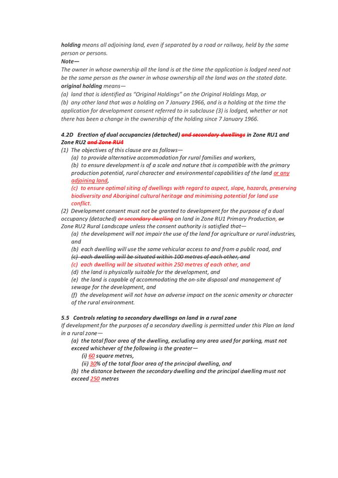
Issue summary: On 18 December 2020, after the Gateway Determination for this planning proposal had been issued, a new optional Standard Instrument Principal Local Environmental Plan Clause 5.5 was introduced. The new clause applies to secondary dwellings in all rural zones and as such creates a double up of controls for secondary dwellings in rural zones with the proposed Clause 4.2D that was the subject of the planning proposal.
Councils have been invited to opt into the new clause by 30 May 2021. After this date Council will need to lodge a sperate planning proposal top opt into the new clause. Details of Clause 5.5 are as follows:
5.5 Controls relating to secondary dwellings on land in a rural zone [optional]
If development for the purposes of a secondary dwelling is permitted under this Plan on land in a rural zone—
(a) the total floor area of the dwelling, excluding any area used for parking, must not exceed whichever of the following is the greater—
(i)[insert number] square metres,
(ii)[insert number]% of the total floor area of the principal dwelling, and
(b) the distance between the secondary dwelling and the principal dwelling must not exceed [insert number] metres
Staff comment: Clause 5.5 requires councils to nominate the maximum square metres and percentage of floor area of the principle dwelling that secondary dwellings in rural areas can be. When adopted BVLEP 2013 had the same standard for secondary dwellings in urban and rural areas of 60m2or 30% of the total floor area of the principal dwelling. All secondary dwellings are currently exempt from Section 7.11 and Section 7.12 contributions.
Recommendation: To avoid duplication of controls for secondary dwellings in rural zones it is recommended that secondary dwellings are removed from draft Clause 4.2D and that Council adopt Clause 5.5 as detailed in Attachment 1.
Financial and resource considerations
The processing of the planning proposal and its public exhibition have been undertaken as part of Council’s regular work program and within the adopted 2020-21 budget.
Legal /Policy
The planning proposal was prepared in accordance with Section 3.33 of the Environmental Planning and Assessment Act 1979 and the NSW Department of Planning, Industry and Environment’s A Guide to Preparing Planning Proposals (December 2018).
Impacts on Strategic/Operational/Asset Management Plan/Risk
Strategic Alignment
The planning proposal aims to achieve the NSW Department of Planning, Industry and Environment’s South East and Tablelands Regional Plan 2036 Directions 24 - Deliver greater housing supply and choice and 28: Manage rural lifestyles.
The planning proposal gives effect to the Bega Valley Shire Local Strategic Planning Statement 2040 Future Direction - Allow for growth and encourage housing diversity and affordability while enhancing the distinct local character of each place.
The planning proposal is consistent with the Bega Valley Shire Community Strategic Plan 2040 goals: Goal 5 - Our air and water is pristine and our natural environment and rural landscapes are protected, and Goal 7 - Our Shire continues to be a vibrant, enjoyable, safe and affordable place to live.
Environment and Climate Change
The intent of the planning proposal is to increase housing diversity and affordability in rural zones without resulting in adverse environmental outcomes, including protecting Aboriginal cultural heritage, biodiversity values and water resources, by permitting better dwelling siting with consideration of the unique constraints of the land.
Economic
The planning proposal supports opportunities to establish more affordable dwellings that are appropriately sited so as not to have any detrimental impact on adjacent economic land uses.
Risk
The planning proposal supports opportunities for better dwelling siting to minimise risk of hazards and impacts upon the land. The planning proposal will not materially increase dwelling density on rural land as detached dual occupancies are already permitted in RU1 and RU2 rural zones. Attached dual occupancies are permitted in all three rural zones (RU1, RU2 and RU4).
Social / Cultural
The planning proposal is anticipated to have positive social and cultural impacts, by supporting the provision of affordable housing options for farmers and other landowners on rural land throughout the Bega Valley Shire, allowing for more opportunities for landowners to age-in-place and to allow for succession planning for farming families.
Attachments
1⇩. Amendments to BVLEP 2013: recommended wording of Clauses 4.2A, 4.2D and 5.5
|
Council |
21 April 2021 |
|
Item 8.2 - Attachment 1 |
Amendments to BVLEP 2013: recommended wording of Clauses 4.2A, 4.2D and 5.5 |
|
Item 8.3 |
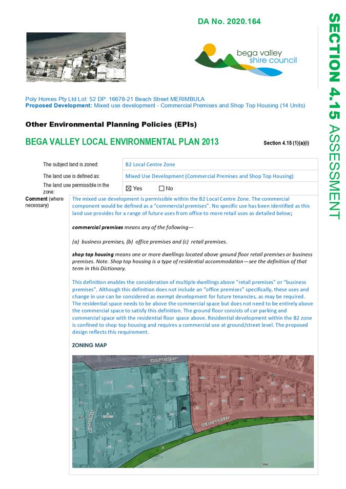
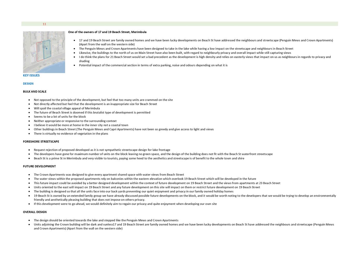
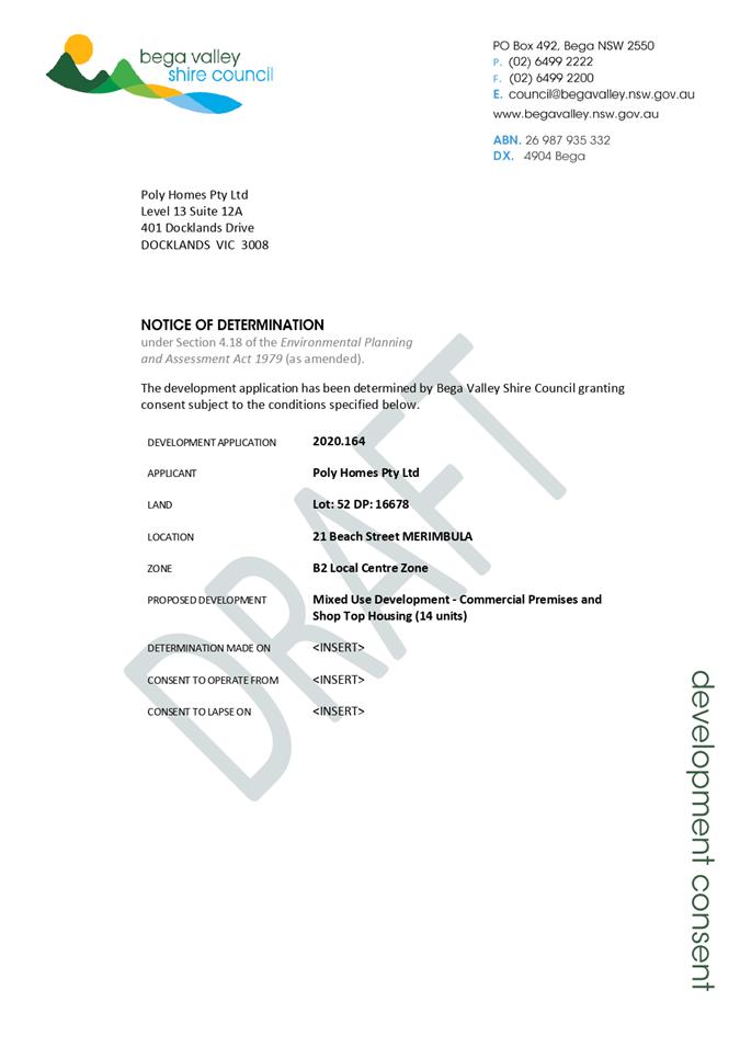
8.3. 2020.164 Mixed Use Development - Commercial Premises and Shop Top Housing (14 Units), Lot 52 DP 16678 21 Beach Street, Merimbula
Director Community Environment and Planning
|
Applicant |
Poly Homes Pty Ltd |
|
Owner |
Poly Homes Pty Ltd |
|
Site |
Lot 52 DP 16678, 21 Beach Street, Merimbula |
|
Zone |
B2 Local Centre Zone |
|
Site area |
1,119m2 |
|
Proposed development |
Mixed Use Development - Commercial Premises and Shop Top Housing (14 Units) |
Executive Summary
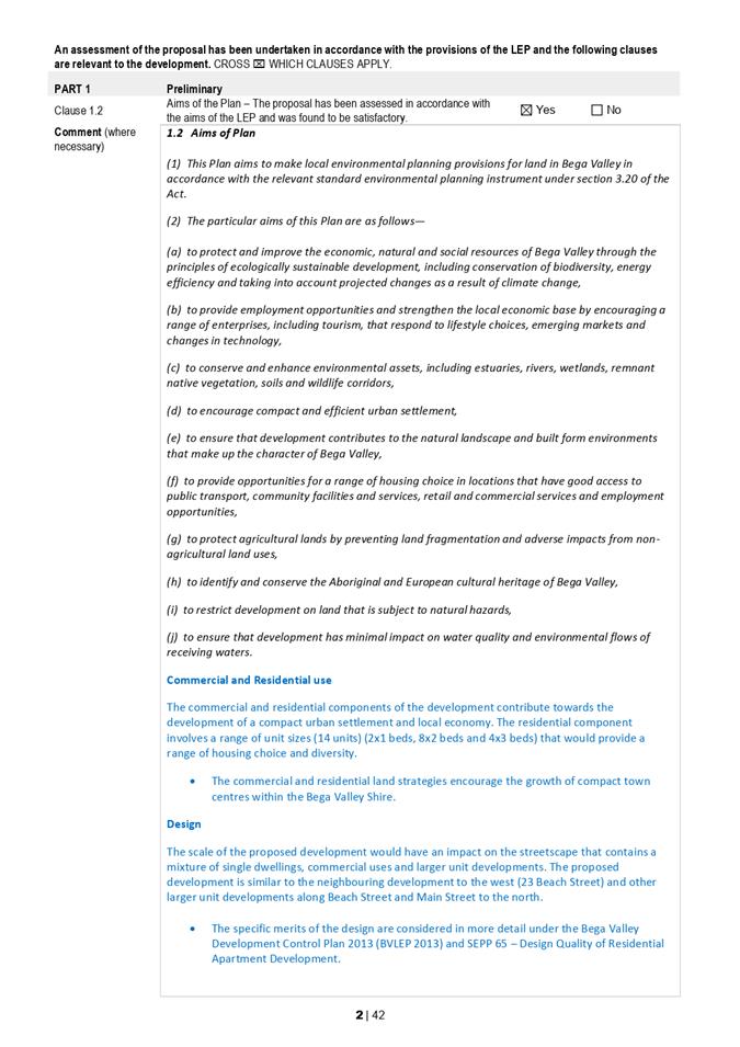
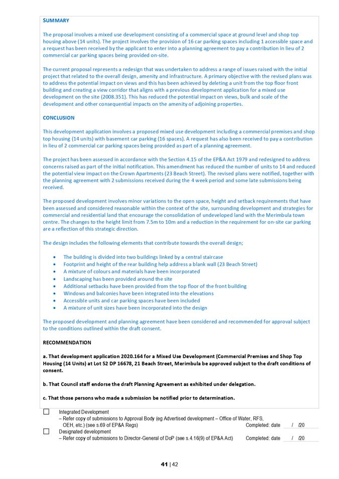
This development application is being reported to Council for determination as the application seeks variations to current development standards relating to setback, height and communal open space and meets the relevant reporting test, being “a DA that has received strong community interest raising a number of matters on planning merit, which in the opinion of the Director Community, Environment and Planning, warrants reporting to Council”.
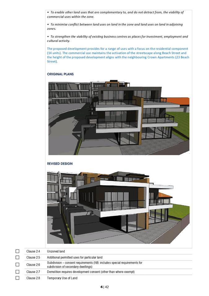
The proposal has been assessed under Section 4.15 of the Environmental Planning and Assessment Act 1979 and the original plans amended by deleting a unit from the top floor to reduce the view sharing impact. The proposed variations are minor and considered reasonable within the context of the site and the surrounding streetscape.
The development is consistent with the adopted strategic direction to encourage consolidation of commercial land with mixed use developments, as reinforced in Council’s adopted land use strategies and Local Strategic Planning Statement (LSPS).
The revised design and planning agreement is recommended for approval subject to the draft conditions of consent provided in Attachment 5.
1. That Council assumes the concurrence of the Secretary of the Department of Planning, Industry and Environment in accordance with Circular PS 18-003 and pursuant to Clause 4.6 of the Bega Valley Local Environmental Plan 2013 and notifies the Department accordingly.
2. That Council approves the variation to the height of building development standard, specified under Clause 4.3(2) of the Bega Valley Local Environmental Plan 2013.
3. That Development Application 2020.164 for Mixed Use Development – Commercial Premises and Shop Top Housing (14 Units) be approved subject to the draft conditions of consent (Attachment 5).
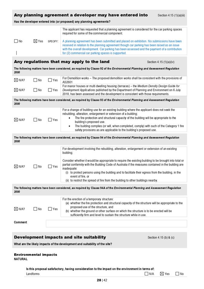
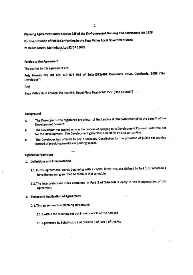
4. That the draft Planning Agreement for the payment of a contribution totalling $34,602 in lieu of two commercial car parking spaces on-site be approved in accordance with the Policy 4.11 Planning Agreements.
5. That people who made a submission be notified of this determination.
Background
There is an existing approval for mixed use development (2008.351) consisting of commercial floor space (169m2) and nine residential units that was approved by Council on 3 February 2010 (Figure 1). This approval was commenced with the removal of an older dwelling but never proceeded.
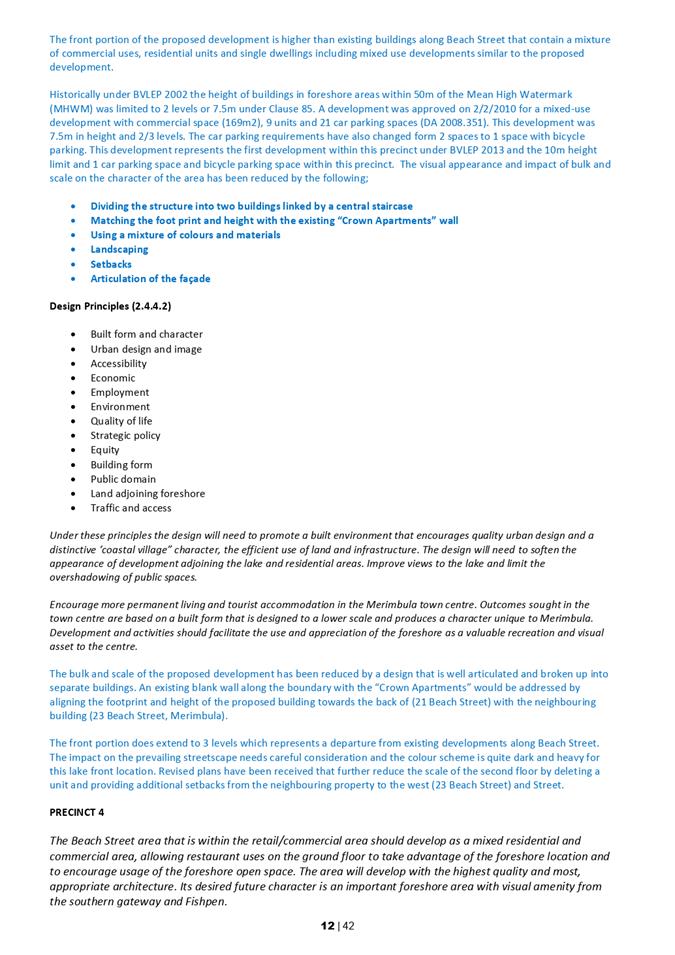
This existing approval was assessed under a different zoning being 3(a) General Business under Bega Valley Local Environmental Plan 2002, which, under Clause 85, had a maximum building height limit of 7.5m within 50m of the mean high water mark. The requirement for car parking spaces has also been reduced from two spaces to one space per unit under the Bega Valley Development Control Plan 2013 (BVDCP 2013).
Description of the proposal
This proposal involves a mixed use development including commercial floor space (98m2) at ground level and 14 shop top housing units above (Figures 2 and 3).
The design consists of two main buildings with a lift well at the centre. The rear building contains four levels with underground basement parking and residential floor space above. The front building includes three levels with commercial space on the ground floor and residential space above.
A planning agreement is proposed for a monetary payment to Council in lieu of two commercial car parking spaces. Minor policy variations have also been requested to Bega Valley Local Environmental Plan 2013 (BVLEP 2013), BVDCP 2013 and State Environmental Planning Policy 65 – Design Quality of Residential Apartment Development.
Revisions have also been made to the original design, including:
· Consolidation of units 8 and 9 reducing the number of units from 15 to 14 units
· Additional setback provided for the top floor from Beach Street
· Two additional car parking spaces allocated to the ground floor commercial premises
See Attachment 1 – Proposed Plans and Attachment 2 – Draft Planning Agreement.
Figure 1 – Existing Approved Plans under DA 2008.351
Figure 2 – Proposed Plans under DA 2020.164
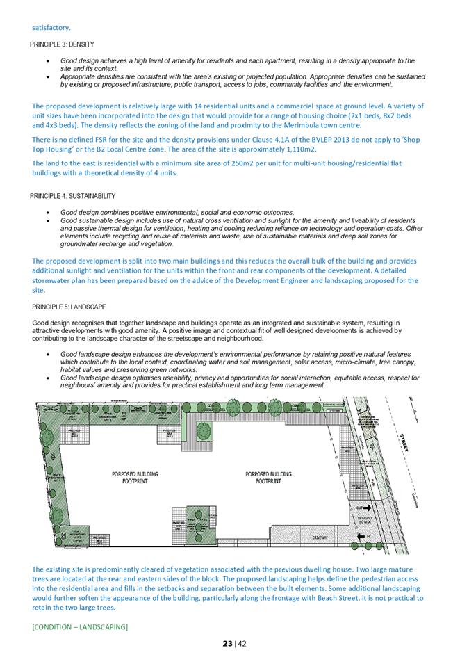
Figure 3 – Building Footprint of Ground Floor
This building footprint provides a reference for the orientation of the site and context within the streetscape.
Description of the site
The site is vacant and covers an area of 1,119m2 with a gentle slope up from street level (Figures 4 and 5). Two large exotic trees are located on the north-western and eastern boundaries. The site is surrounded by existing larger mixed use developments and older style residential unit complexes with some dwelling houses to the east on the northern side of Beach Street.
Figure 4 – Locality plan
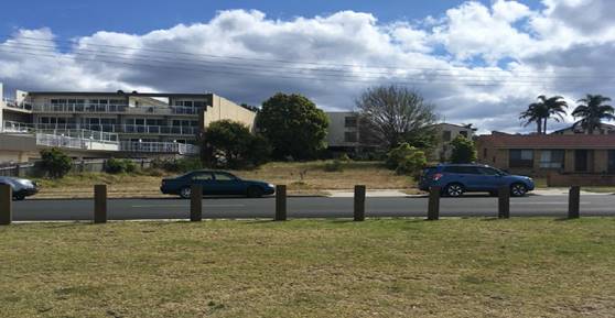
Figure 5 – View from Beach Street
Planning Assessment
The proposal has been assessed in accordance with the matters for consideration under Section 4.15 of the Environmental Planning and Assessment Act 1979 (Attachment 3 – Section 4.15 Assessment). The original plans have been redesigned to address concerns raised as part of the initial assessment and notification process.
Bega Valley Local Environmental Plan 2013
The development has been assessed in accordance with BVLEP 2013. The land is zoned B2 Local Centre under the BVLEP 2013 (Figure 6) and is located on the eastern side of the Merimbula town centre. The proposal involves a mixed use development consisting of a commercial premises and shop top housing.
The following definition applies:
Shop Top Housing means one or more dwellings located above ground floor retail premises or business premises.
A portion of the residential use is located above the commercial component which is located adjacent to Beach Street which meets the definition.
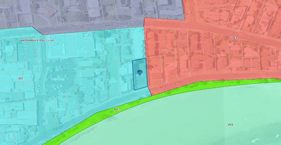
Figure 6 – Zoning map
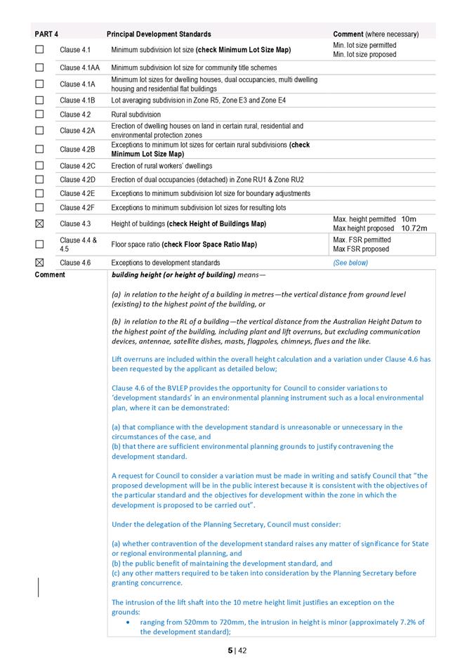
Height and storeys
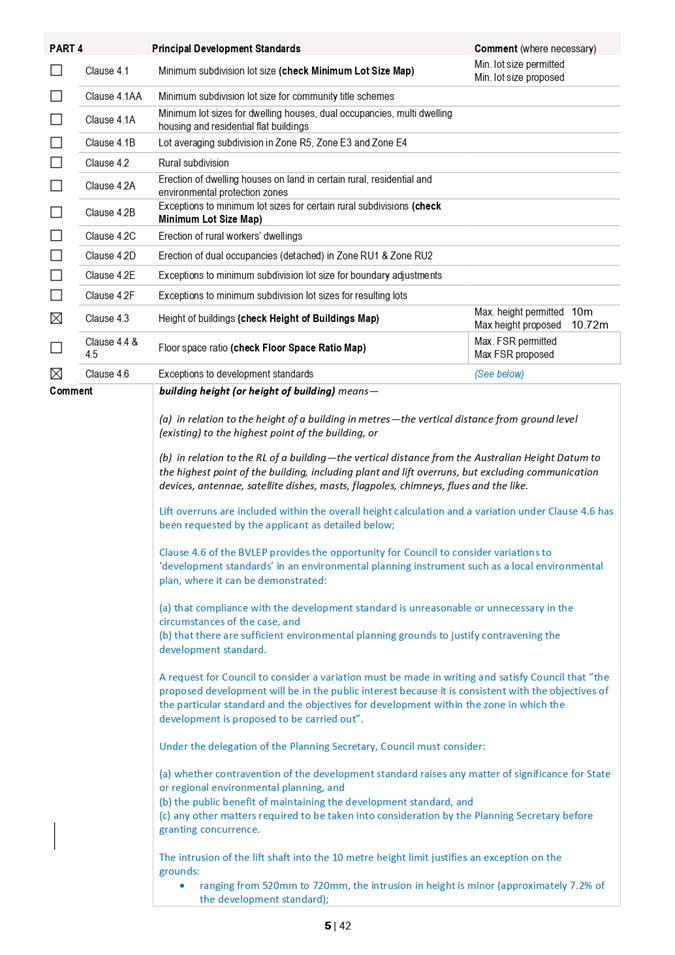
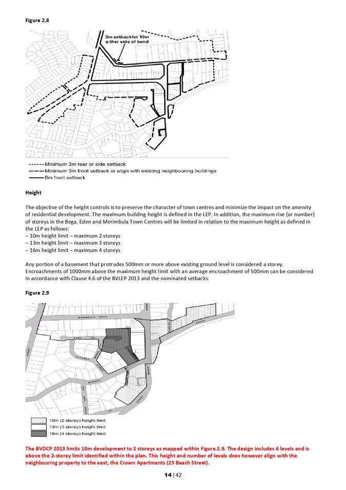
A 10-metre height limit currently applies to the site which is measured from “existing ground level” to the highest point of the building. Building height is defined as follows:
Building Height (or height of building) means—
(a) in relation to the height of a building in metres—the vertical distance from ground level (existing) to the highest point of the building, or
(b) in relation to the RL of a building—the vertical distance from the Australian Height Datum to the highest point of the building, including plant and lift overruns, but excluding communication devices, antennae, satellite dishes, masts, flagpoles, chimneys, flues and the like.
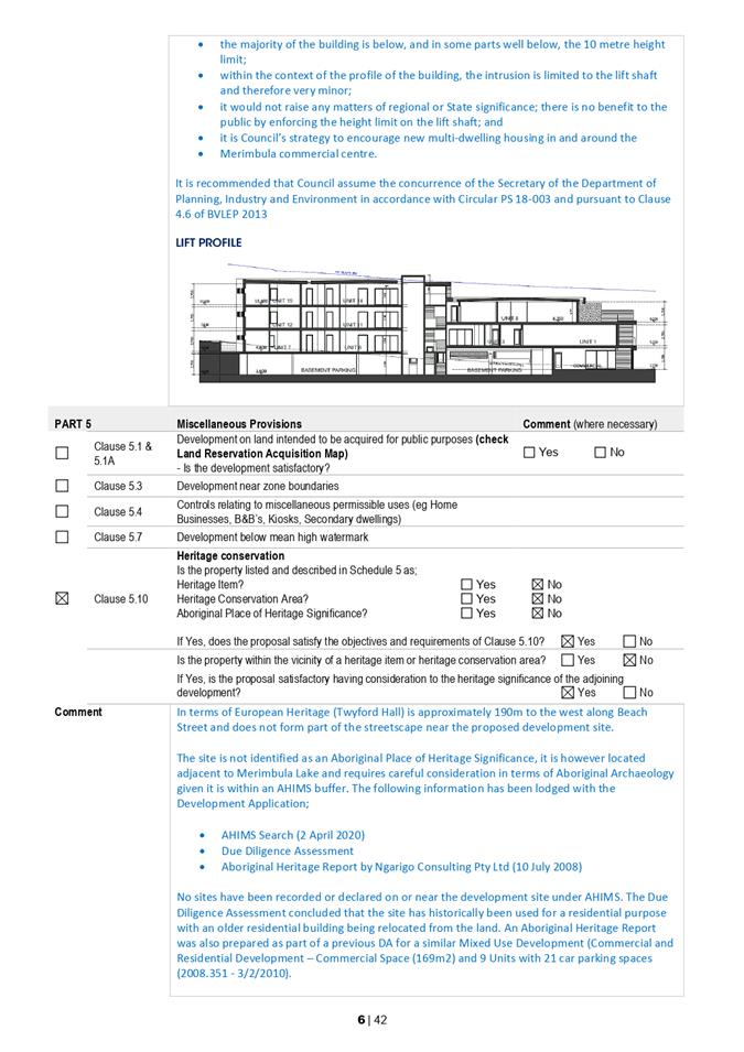
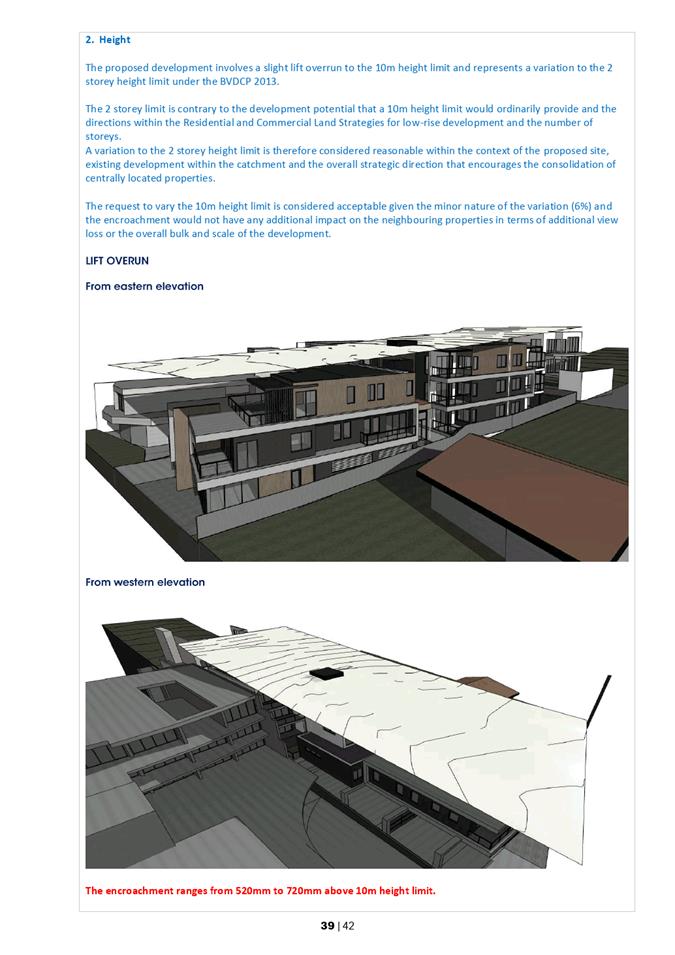
The design includes a lift overrun that would encroach above the 10m height limit of between 520mm and 720mm depending on the final configuration of the lift.
Variation under Clause 4.6
A variation has been requested to the 10m height limit under Clause 4.6 of BVLEP 2013. The variation is considered to be minor (Figure 7), being up to 7.2% and would not have any additional impact on view sharing or the streetscape. The concurrence of the Secretary of the Department of Planning, Industry and Environment can be assumed in this instance, in accordance with the provisions of Planning Circular PS 18-003.
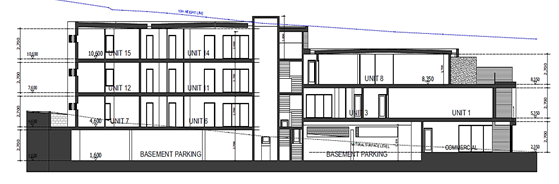
Figure 7 – Lift profile and extent of variation
Bega Valley Development Control Plan 2013
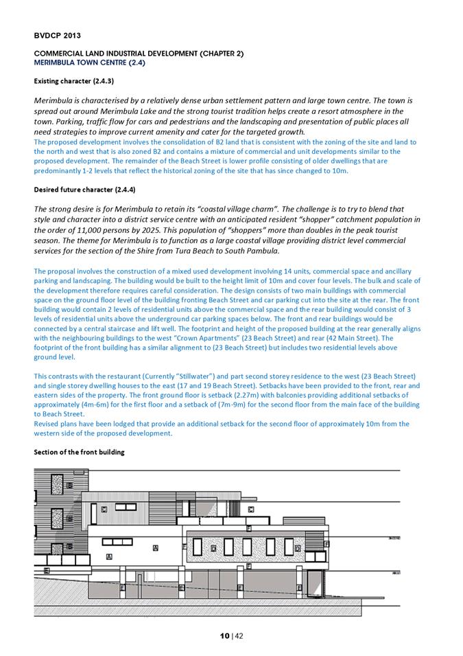
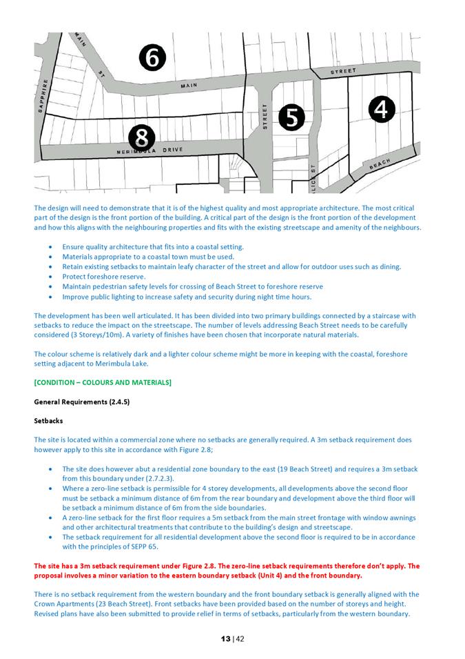
The proposal has been assessed in accordance with BVDCP 2013 and more specifically Chapters 2, 3 and 5 that relate to commercial and residential development. The revised design has been assessed in accordance with the design principles outlined within these chapters and the future character statements for Merimbula. Two minor variations are proposed to the two storey height limit under Chapter 2.7.1.3 and 3 metre setback under Chapter 2.7.2.3.
Design
The bulk and scale of the building is broken up into two main buildings with the smaller building at the front and larger building recessed towards the rear of the site that is divided by a lift well. The design incorporates a mixture of colours and materials with timber elements and an integrated floor, wall and roof profile across the second level of both buildings that provides a modern profile and visual connection between both buildings.
Landscaping has been integrated into the design with a mixture of plant species.
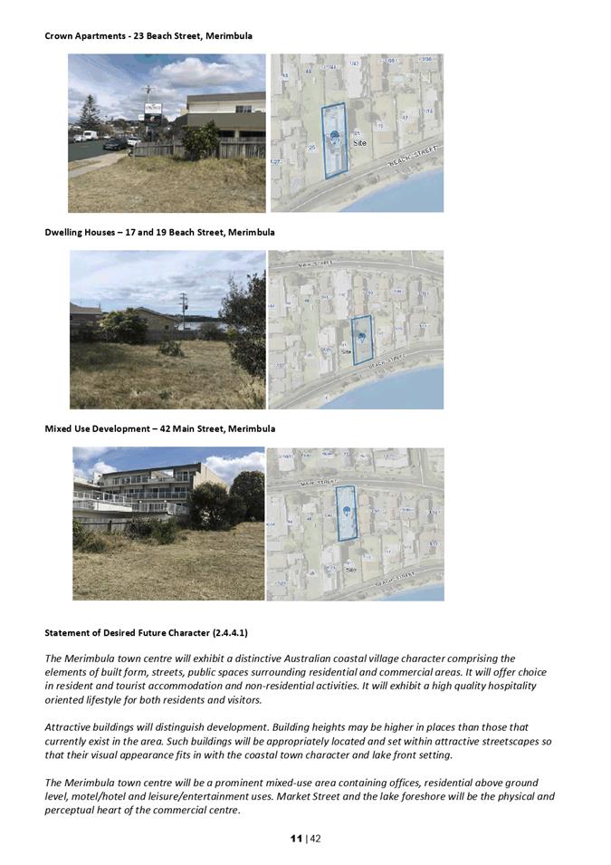
The rear building aligns with the neighbouring unit complex at 23 Beach Street (The Crown Apartments) that currently presents an unarticulated brick wall on the western boundary.
A variation to the two storey height limit is considered reasonable given the development is consistent with the 10m height limit under BVLEP 2013.The assessment of the DA has highlighted this inconstancy between BVLEP 2013 and BVDCP 2013. Where there is such an inconsistency, BVLEP 2013 prevails. Development of the site involves significant excavation works to provide car parking spaces and requires a particular density of units in order to make the project economically viable.
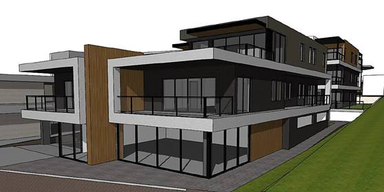
Figure 8 – Perspective
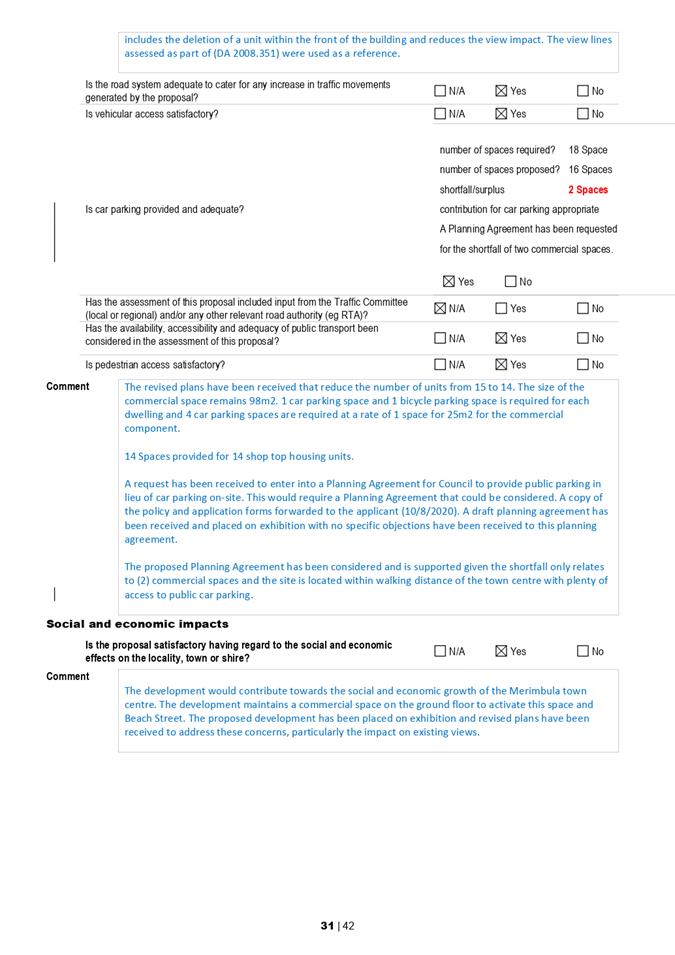
Car Parking
The proposed development consists of commercial space totalling 98m2 and shop top housing (14 units). The commercial space requires four car parking spaces at a rate of one space per 25m2 and shop top housing has a requirement of one car parking space and one bicycling parking space per unit. The proposed development therefore requires a total of 18 car parking spaces (14 car parking spaces for the units) and (four car parking spaces for the commercial space).
A total of 16 car parking spaces are proposed including the following:
· 14 car parking spaces for each residential unit
· Two spaces for the commercial space (including one accessible space)
· A planning agreement has been requested to provide a monetary payment to Council for two commercial spaces elsewhere in the locality.
The development includes an underground car parking level and a geotechnical report would need to be undertaken as a condition of consent to ensure the neighbouring properties are adequately protected. The completion of a geotechnical report is not considered necessary to establish the merits of the development but considered essential prior to construction.
The issue of existing car parking availability and traffic congestion within the Merimbula town centre and on Beach Street has been raised as an issue as part of the exhibition process.
Car parking has been provided for the residential component in accordance with BVDCP 2013 and a request to enter into a Planning Agreement with Council for the commercial shortfall is considered to be reasonable and consistent with Council policy.
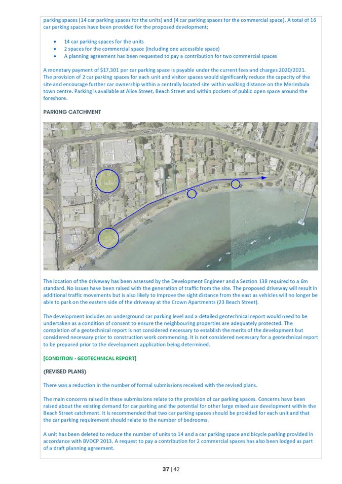
Public car parking is available within the immediate area along the Beach Street foreshore and Alice Street (Figure 9). The site is located within the commercial town centre catchment and entering into a Planning Agreement is available for the commercial floor space only.
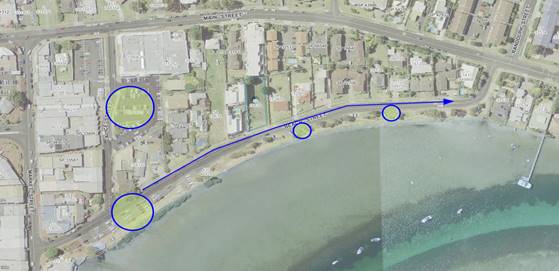
Figure 9 – Car Parking Catchment
Amenity
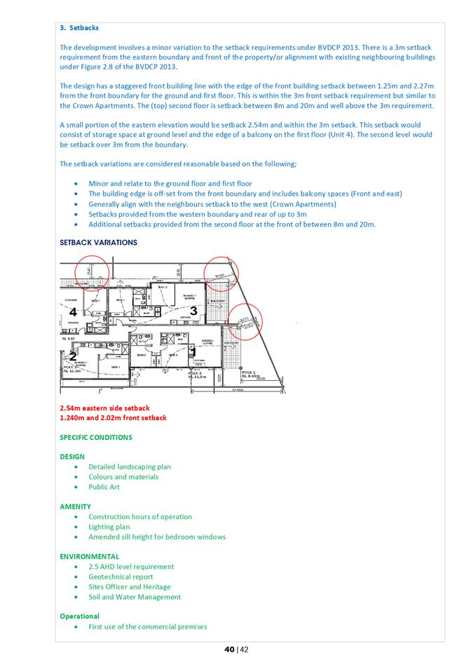
A 3m setback is required across the front, eastern and rear boundaries of the site under Chapter 2.7.2.3 of the BVDCP 2013.
A minor variation has been requested to the front and eastern boundary setbacks for the second floor balconies. The 3m setback is generally provided to the eastern boundary however would reduce the setback to 2.540 metres for the length of the balcony. The front setback would vary from 5.56m to 1.240 m. This request is considered reasonable due the minor nature of the departures and the staggered building line across the Beach Street frontage that is similar to the neighbouring property to the west at 23 Beach Street (The Crown Apartments).
Additional setbacks are also proposed from the western boundary well above the zero line permitted under the DCP.
An increase in the sill height for windows across the eastern elevation and treatment with solid balconies has also been discussed with the Applicant to address concerns raised by the adjoining landowners and this would be reinforced as a condition of any development approval.
The project is considered well designed with additional setbacks that would be well above the 3m minimum being provided across the property frontage (Figure 10). The revised plans increased these setbacks to over 20m from the top floor in line with the view line that was established as part of the assessment of the existing approved development (2008.351).
This has not only reduced the impact on the streetscape but provided additional amenity for the neighbouring units to the west at 23 Beach Street (The Crown Apartments).
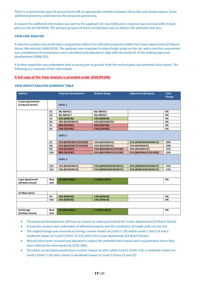
The proposed development site is vacant and would have an impact on view sharing, particularly from 23 Beach Street (The Crown Apartments) (Figure 11). A view loss assessment has been undertaken in accordance with the more specific criteria contained within Chapters 2.4 and 3.2.2.6 of the BVDCP 2013 and the Principles of view sharing: The impact on neighbours – Tenacity Consulting v Warringah.
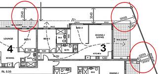
Figure 10 – Setback Variations
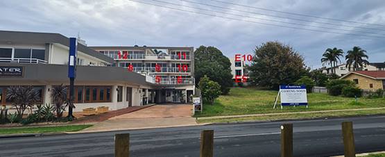
Figure 11 – Most affected properties
Principles of View Sharing
First Step The first step is the assessment of views to be affected. Water views are valued more highly than land views. Iconic views (eg of the Opera House, the Harbour Bridge or North Head) are valued more highly than views without icons. Whole views are valued more highly than partial views, eg a water view in which the interface between land and water is visible is more valuable than one in which it is obscured.
Second Step The second step is to consider from what part of the property the views are obtained. For example, the protection of views across side boundaries is more difficult than the protection of views from front and rear boundaries. In addition, whether the view is enjoyed from a standing or sitting position may also be relevant. Sitting views are more difficult to protect than standing views. The expectation to retain side views and sitting views is often unrealistic.
Third Step The third step is to assess the extent of the impact. This should be done for the whole of the property, not just for the view that is affected. The impact on views from living areas is more significant than from bedrooms or service areas (though views from kitchens are highly valued because people spend so much time in them). The impact may be assessed quantitatively, but in many cases this can be meaningless. For example, it is unhelpful to say that the view loss is 20% if it includes one of the sails of the Opera House. It is usually more useful to assess the view loss qualitatively as negligible, minor, moderate, severe or devastating.
Fourth Step The fourth step is to assess the reasonableness of the proposal that is causing the impact. A development that complies with all planning controls would be considered more reasonable than one that breaches them. Where an impact on views arises as a result of non-compliance with one or more planning controls, even a moderate impact may be considered unreasonable. With a complying proposal, the question should be asked whether a more skilful design could provide the applicant with the same development potential and amenity and reduce the impact on the views of neighbours. If the answer to that question is no, then the view impact of a complying development would probably be considered acceptable and the view sharing reasonable.
Height poles were placed on the site and access obtained to the units at 23 Beach Street (The Crown Apartments). This review concluded that the proposed development would have an impact have an impact on the following views:
· Merimbula Lake
· Spencers Park
· Mitchies Jetty
· The Merimbula Wharf
· Coastal Headlands
· The main channel and beach interface
· Oyster leases
Existing views towards Mitchies Jetty and the Merimbula Wharf are identified as iconic views for the Far South Coast.
View Impact Analysis
The proposed development will have an impact on views given the site is currently vacant and the neighbouring properties are oriented to obtain views across the proposed development site. The units within 23 Beach Street (The Crown Apartments) would be particularly affected given they are setback towards the rear of the site (Reflecting previous height limits) and the primary view catchment is to the south-east (Figure 12).
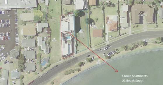
Figure 12 – View line from 23 Beach Street (The Crown Apartments)
The view impact analysis of the originally submitted design determined that the proposed development would have a severe impact on the units within levels 1 and 2 of 23 Beach Street (The Crown Apartments).
Any development above a single storey on the proposed development site will impact on the views currently obtained from units within Level 1. After inspecting the units within Level 2 it was determined that there was an opportunity for the development to be redesigned to reduce this impact.
Revised plans were submitted and further refined to align with the view corridor established under the existing approved development (DA 2008.351) (Figure 13). This required the deletion of a penthouse unit within the top floor (achieved through the consolidation of Units 8 and 9).
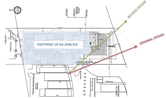
Figure 13 – Revised view line across the proposed top floor (Proposed Unit 8)
Summary of view loss analysis
· The height limit for the foreshore area of the B2 Local Centre Zone has increased from 7.5m under BVLEP 2002 to 10m under the BVLEP 2013
· The proposed development will have an impact on views (particularly The Crown Apartments)
· A view loss assessment was undertaken through inspection of affected property and installation of height poles on the site
· The original design was assessed as having a severe impact on Levels 1 and 2
· Revised plans were received and adjusted to reduce the potential view impact
· Any development above a single storey would impact on Level 1 (Units 3-6) and the views from these units are already obscured by an existing pool and balustrade
· The majority of existing views are obtained across a side boundary that are difficult to protect
· Revised plans have been received and reduced the potential view impact by deleting a unit and aligning the development with a view corridor established through the assessment of an existing development approved on the site (2008.351)
· The latest revised plans have reduced the potential view loss for 23 Beach Street (The Crown Apartments) and the impact is considered reasonable under the view sharing principles and Clause 3.2.2.6 of BVDCP 2013
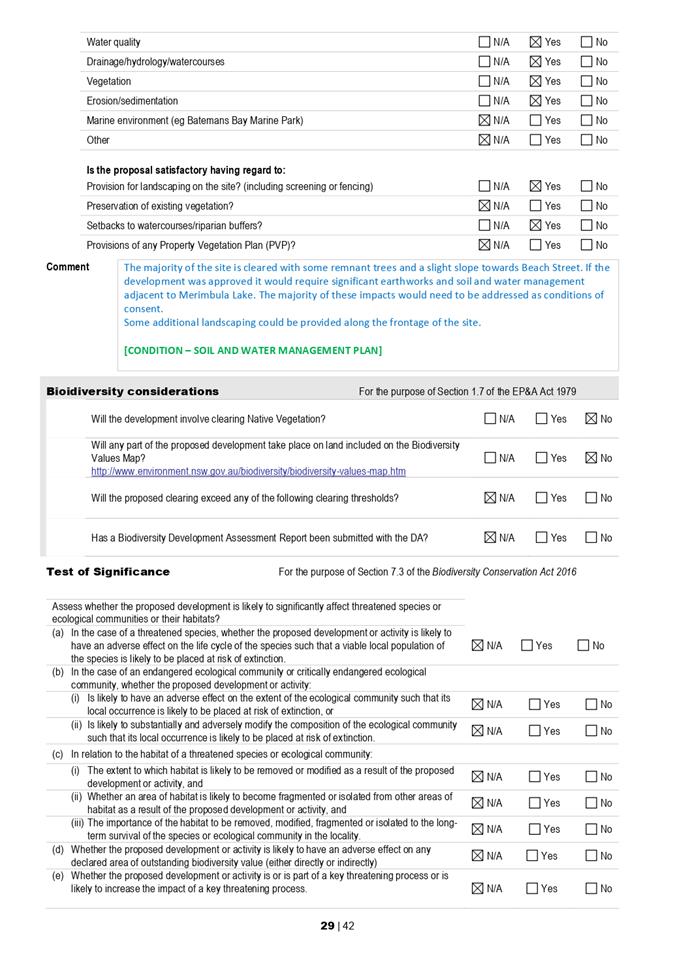
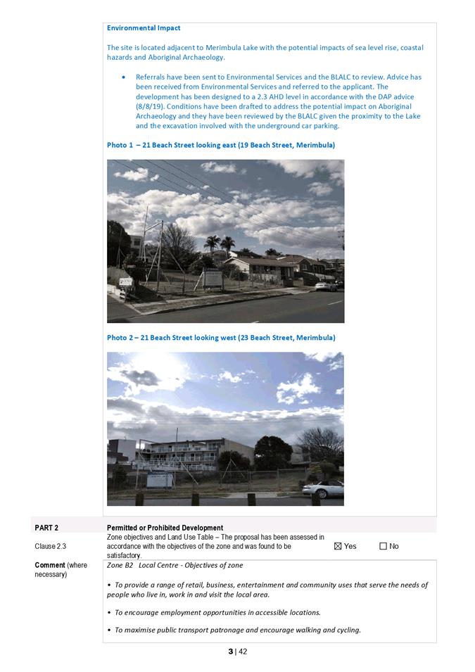
Environment
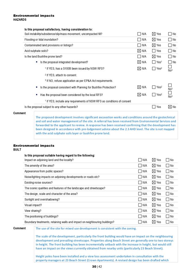
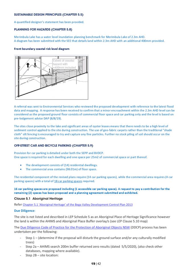
The site is located next to Merimbula Lake and involves significant earthworks and would require the implementation of soil and water management measures and a geotechnical report prior to works commencing.
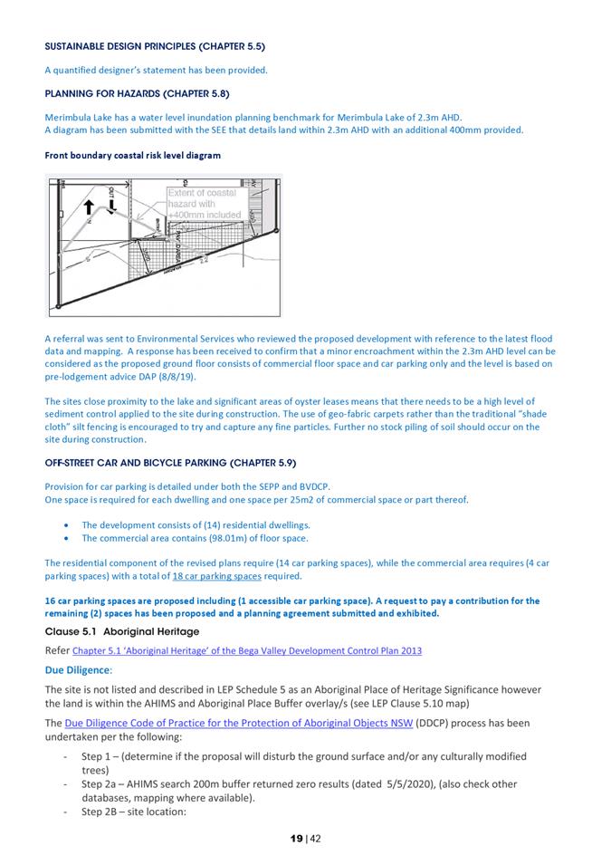
The proposed building has also been designed in accordance with the 2.3 mAHD coastal risk level in accordance with pre-lodgement advice.
The Bega Local Aboriginal Land Council (BLALC) has also reviewed the proposal, in terms of site disturbance and a condition has been recommended on the draft consent to require a suitably qualified person to be on site during initial ground disturbance works.
The proposed development is consistent with more general requirements contained within Chapter 5 of the BVDCP 2013.
State Environmental Planning Policies
Two SEPPs are of particular relevance to this development. They are SEPP 65 – Design Quality of Residential Development and the Coastal Management SEPP.
Coastal Management SEPP
The bulk and scale of the development has been reduced by splitting the building into two main components at the front and rear of the site. This breaks up the overall density of the building and provides solar access through the centre.
The front building has been addressed with incremental setbacks for each of the three levels. The site and foreshore area along Beach Street has historically been limited to a 7.5m height and the proposed development does represent a new element within this foreshore streetscape.
The applicant has provided revised plans that reduce the impact on existing views and overall bulk and scale of the development when viewed from Beach Street and the broader coastal environment around Merimbula Lake.
SEPP 65 – Design Quality of Residential Development
The Design Quality SEPP applies to the proposed development as it is three storeys or more above ground level and the building contains at least four or more dwellings. A Design Verification Statement that includes a response to the Apartment Design Code has been provided by the applicant.
The site is located on the edge of a B2 Zone and contains a mixture of more commercial uses to the west and residential uses to the east. The area along Beach Street contains a mixture of commercial, residential and mixed use developments that vary from low density single dwellings to larger mixed use developments similar to the development proposed. The bulk and scale has been reduced by dividing the development into two main buildings divided by a central lift and staircase section.
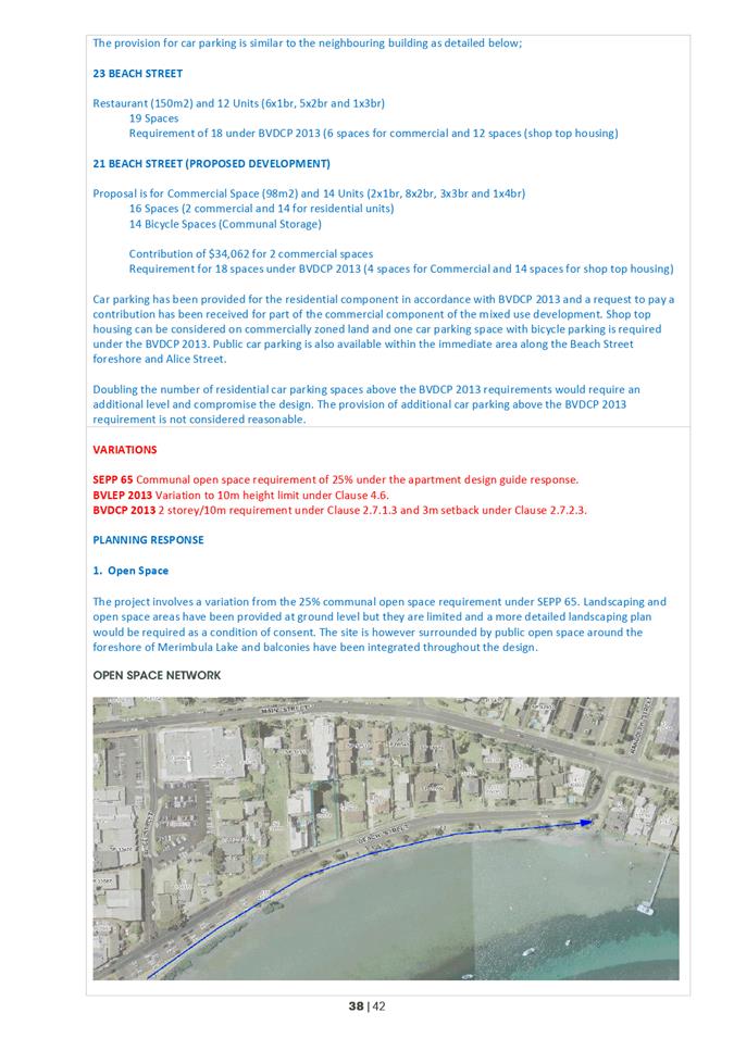
The guide recommends that 25% of the land area should be devoted to communal open space. The proposed development only provides for 4.6% communal open space and the applicant has requested a variation to the required 25%. Open space has been provided along the rear and eastern side of the property and within balcony spaces for each unit. There is not enough site area or available height to devote a quarter of the site area to communal open space. A network of open space (Figure 14) is available around the Merimbula Lake foreshore and immediately available on Beach Street, with assessing staff concluding that strict compliance with the standard having considered the particular circumstances of this development, would be unreasonable and unnecessary. The variation is considered to be well founded.
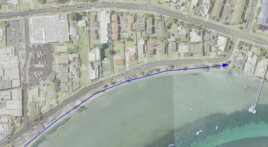
Figure 14 – Open space network
Bega Valley Local Strategic Planning Statement (LSPS)
The proposed development is consistent with the following statements within the LSPS:
· Buildings are higher in some places than those that currently exist in the town.
· Taller buildings are appropriately located and set within attractive streetscapes so that their visual appearance fits in with the coastal town character and lake front setting.
· Larger development is well articulated and proportioned with the overall height, bulk and scale in keeping with a medium-rise coastal setting.
· The town centre is a prominent mixed-use area containing offices, shop-top housing, tourist accommodation and leisure/ entertainment uses.
· The density and diversity of housing close to the town centre has increased and contributes to the vitality of the town.
Commercial and Residential Land Strategies
The following directions apply within the Commercial Land Strategy 2040:
· Investigate incentives for shop top housing to help facilitate greater housing diversity and supply in commercial centres, it is recommended that Council investigate a range of options to incentivise development of shop-top housing in Merimbula and Bega. This may include increases in height limits or reduction in headworks or developer contributions.
· A range of building heights enables diverse forms whilst ensuring new development respects the landform and position relative to the waterfront. High quality upper floor accommodation is encouraged to take advantage of views and lifestyle opportunities.
· Height of building limits play an important role in stimulating redevelopment and urban renewal while maintaining desired character and limiting unwanted impacts.
· Protect key elements within the streetscape including view corridors and access to Merimbula Lake where larger development is well articulated and proportioned and the overall height, bulk and scale is in keeping with a medium-rise coastal setting.
· Enhance the existing coastal atmosphere of Merimbula as a vibrant seaside
destination with a mixture of commercial and residential land uses where streetscape elements such as awnings and signage are well articulated, proportioned and the redevelopment of older building stock is encouraged.
The following directions are contained within the Residential Land Strategy 2040:
· Merimbula is identified as a major centre with medium-rise apartments and townhouses - two to four stories close to the commercial centre.
· Review the planning controls for R3 Medium Density Residential zoned land including potential for varying planning controls within R3 zones (differing height, floor space ratios and minimum lot sizes within R3 zones) to encourage greater diversity and development uptake.
The development is consistent with these strategic directions that encourage consolidation of commercial land with mixed use development where the ground level commercial component provides for the activation of the street and the residential component provides accommodation where people can live within walking distance of all amenities and help to breathe life into our town centres.
Options
The following options are available to Council, in its consideration of this matter:
1. Approve the Development Application subject to the draft Conditions of Consent. This is the recommended option.
2. Defer consideration of the matter and request a separate report identifying any relevant Section 4.15 Matters for Consideration and draft Reasons for Refusal.
3. Defer consideration of the matter and seek an alternative design to address any concerns raised (to be specified by Councillors).
Community and Stakeholder Engagement
Engagement undertaken
The proposed development was notified in accordance with Council’s adopted Community Engagement Strategy. The catchment area for notification was extended beyond just adjacent and adjoining properties.
The original design was notified from 11 June 2020 until 25 June 2020 with 11 submissions received. The revised plans were notified from 27 October 2020 until 24 November 2020 with two submissions received. The two submissions received to the revised plans were from people who made submissions during the original notification period and the issues have been addressed in conjunction with the original submission in the Summary of Submissions (Attachment 4)
Design
· Bulk and scale
· Foreshore streetscape
· Future Development
· Overall design
· Precedent
· Tree removal
Staff Comment
The proposed development is zoned B2 Local Centre under the BVLEP 2013 and generally complies with the 10m height limit. The building envelope for the proposed development is not limited in terms of floor space ratio.
The overall bulk and scale of the proposed development has been reduced by dividing the building into two primary components with a lift well at the centre. The front component of the development is at a reduced scale with balconies and setbacks from Beach Street. The building envelope aligns with the neighbouring properties and the development is broken up with a mixture of colours and materials and modern roof profile.
Revised plans have been received for this proposed development and although the primary purposed is to reduce the view impact, it has also reduced the overall scale of the development by deleting a unit from the top floor.
The proposed units are generally oriented towards the south-east view corridor with corner decks and bedroom windows within the eastern elevation of each level. Landscaping is proposed within a 2.5m-3m setback along the eastern boundary with the neighbouring property to the east (19 Beach Street) containing an existing single storey dwelling house on a large allotment similar to the proposed development site that is likely to be developed in the future.
Windows and openings provide greater articulation to the eastern elevation and will result in a better design outcome. The existing wall along the western side of the property provides an example of why a setback and articulation of the eastern elevation is important and why addressing this unarticulated wall is a key aspect on this proposed design.
The neighbouring property is zoned Residential (R3) with a slightly different planning framework to work within and any future development on the neighbouring property will be treated on its merits and the requirements that apply at the time of lodgement.
The orientation of the units and setback provided within this proposed development and required as part of developing the neighbouring property will help protect the amenity of both properties and provide some opportunity these south-easterly views to be retained. As with the neighbouring Crown Apartments, these views will be enjoyed for a period of time, but likely to be impacted by any future development on 19 Beach Street.
The degree of impact will vary based on the elevation and location of each unit. As with this development, the reasonableness of this view impact will be assessed and this would not prevent development of a similar scale on (19 Beach Street). Any future development will be considered within the context of the neighbouring property and this may result in an amendment to the original design where an opportunity is available to address a more specific impact on amenity or design in a similar way to how the assessment of this proposed development has been approached.
The immediate area contains a number of larger unit developments, including mixed use developments similar to the development proposed. The scale of the development reflects the prevailing zoning and size of the allotments along Beach Street that will be incrementally developed. The site is on the edge of a commercial and residential zone where the size of the allotments incrementally reduces as you travel east, providing natural limitation to the overall scale of development along the Beach Street foreshore.
The site does contain two mature trees that would need to be removed. Unfortunately, it is not practical to retain them during construction works and any development would comprise the root zone of both trees. A concept landscaping plan has been submitted and a more detailed landscaping plan would be required as a condition of consent.
Council’s residential and commercial land strategies and LSPS encourage the consolidation and development of centrally located properties similar to the proposed development to ensure the development potential of this land is fully realized. In this respect the height limit within the foreshore zone increased from 7.5m to 10m and the residential component can be considered under the definition of shop top housing with a requirement for only one car parking and bicycle parking space under the BVLEP 2013.
In summary, the current planning policy and strategies are actively encouraging the development of commercial land with a mixture of commercial and residential development that encourages the activation of our town centres.
Amenity
· Loss of privacy
· Solar Access
· View loss
· Noise
· Commercial space
Staff Comment
The proposed development will have an impact on privacy, overshadowing and views.
Privacy
The bedroom windows and balcony spaces will overlook the property to the east (19 Beach Street). A setback of between 2.5 and 3m has been provided and landscaping in between. The adjoining property consists of a single dwelling house on a larger allotment similar to the subject land and likely to be developed in the future.
The balcony and window openings do provide articulation of the eastern elevation as opposed to a blank wall along this boundary. This is a better outcome than other developments within this streetscape. The opportunity to raise the sill height of these windows and the installation of solid deck balustrades has been discussed with the applicant and has been reinforced as a recommended condition of consent.
View Loss
A primary consideration with this development has been the impact on views. The original plans would have had a severe impact on a number of units within the Crown Apartments (23 Beach Street). After reviewing the plans, it was identified that a more considered design could reduce this impact. Revised plans were submitted and further refined to establish a view corridor that aligns with the view corridor established with the existing approved development under the previous approved DA2008.351.
This has resulted in the loss of a unit within the top floor, but has reduced the potential view impact from a severe to moderate impact in most cases as views to the ocean entrance, headland, beach and the more iconic view of Mitchies Jetty has been retained where possible. There would still be an impact on the ground floor units within the Crown Apartments (23 Beach Street) as any development above a single storey will take these existing views that are already partially obscured by a pool and balustrade in some cases.
Revised plans have been provided and the view loss is now considered reasonable. The deletion of the unit has also reduced the solar impact on the Crown Apartments (23 Beach Street) that includes a pool and outdoor space. The top floor will be setback nearly 20m from Beach Street and the front portion of the development would be setback from the western boundary. The rear component of the development aligns with the existing wall of the Crown Apartments (23 Beach Street) and further reduces any potential impact on access to sunlight.
There would be an impact on the existing single storey dwelling house at (19 Beach Street). Some relief is provided by the proposed setback from the eastern boundary and the property is already overshadowed by a large tree that sits on this boundary line. The overshadowing would mostly impact on open space as the dwelling house is located closer to the eastern side of the block and oriented to the south-east. The property to the east is also likely to be further developed in the future.
The units can be used for permanent or short term letting. A commercial component is required on the ground floor as the site is located within the B2 Local Centre Zone. A development application (or Complying Development Certificate in some circumstances) would be required for the first use as a condition of consent where the more specific design aspects of this commercial space would be assessed including signage, noise and hours of operation.
Infrastructure
· Car parking and traffic
· Structural integrity and risk
Staff Comment
Revised plans
The main concerns raised in these submissions relate to the provision of car parking spaces.
Concerns have been raised about the existing demand for car parking and the potential for other large mixed use development within the Beach Street catchment. It is recommended that two car parking spaces should be provided for each unit and that the car parking requirement should relate to the number of bedrooms.
A unit has been deleted to reduce the number of units to 14 and a car parking space and bicycle parking provided in accordance with BVDCP 2013. A request to provide a monetary payment for two commercial spaces has also been lodged as part of a draft planning agreement, in accordance with Council’s adopted policy.
The provision for car parking is similar to the neighbouring building as detailed below:
23 Beach Street (The Crown Apartments)
Restaurant (150m2) and 12 Units (6x1br, 5x2br and 1x3br)
· 19 car parking spaces
· Requirement for 18 under BVDCP 2013 (six spaces for commercial and 12 spaces for shop top housing)
21 Beach Street (the proposed development)
Proposal is for Commercial Space (98m2) and 14 Units (2x1br, 8x2br, 3x3br and 1x4br)
· 16 car parking spaces (two commercial and 14 for residential units)
· 14 bicycle parking spaces (Communal Storage)
· Contribution of $34,062 for two commercial car parking spaces
· Requirement for 18 spaces under BVDCP 2013 (four spaces for commercial and 14 spaces for shop top housing)
The location of the driveway has been assessed by Council’s Development Engineer and a Section 138 Roads Approval issued. No issues have been raised with the generation of traffic from the site. The proposed driveway will result in additional traffic movements but is also likely to improve the sight distance from the east as vehicles will no longer be able to park on the eastern side of the driveway at 23 Beach Street (The Crown Apartments).
Summary
The proposed development involves the following variations:
· Open Space (25% communal open space under SEPP 65)
· Height (10m height limit under BVLEP 2013 and two storey limit under BVDCP 2013)
· Setbacks (3m requirement under BVDCP 2013)
These variations are considered reasonable within the context of the site, surrounding development and the overall strategic directions within the LSPS and the commercial and residential land strategies that encourages the consolidation of vacant land with the Merimbula town centre.
The increase in the height limit from 7.5m under BVLEP 2002 to 10m under the BVELP 2013 and reduction in car parking requirements under BVDCP 2013 are an example.
The proposed development provides for the consolidation of an existing vacant parcel of commercial land with a mixed use development land within the Merimbula town centre.
The potential impact on the site and streetscape has been addressed by the following;
Design
· The bulk and scale is reduced by dividing the development into two buildings divided by a central lift well
· The design is well articulated with an integrated floor, wall and roofline around the second storey that provides a connection between the two buildings
· The footprint and height of the rear building help to address an existing blank wall on the western boundary (23 Beach Street)
· Additional setbacks above the minimum 3m requirement provided from the western and southern boundary with Beach Street.
· A mixture of colours and materials including natural timber finishes are proposed
· Landscaping has been integrated into the overall design.
Amenity
· Revised plans have been provided to address the view sharing opportunities
· The view line established under DA2008.351 has been used as a reference for the top floor building element and the impact has been reduced from severe to moderate/minor where possible
· A condition is recommended to raise the sill height for windows across the eastern elevation and solid balustrades are provided to protect privacy.
Environment
· The development has been built to 2.3 AHD to address coastal risk
· Aboriginal due diligence has been assessed and these protocols would be reinforced as a condition of consent.
· A geotechnical report and soil and water management measures are required and this has been reinforced as a condition of consent.
Engagement planned
No further engagement is planned, other than to advise submitters and the applicant of Council’s determination.
Financial and Resource Considerations
Assessing proposals for development is part of the regular business of Council and resourcing to undertake that function is included in Council’s adopted 2020-21 Budget.
Legal /Policy
The proposal involves a minor variation to the 10m height limit under Clause 4.6 of BVLEP 2013. The development application has been assessed under assumed concurrence given the variation is minor.
Refusal of the Development Application could be subject to an appeal in the Land and Environment Court, which would have cost impacts to defend Council’s position.
Impacts on Strategic/Operational/Asset Management Plan/Risk
Strategic Alignment
The revised plans are consistent with the goals outlined in the Community Strategic Plan 2040 and in particular Goals 7 and 8:
· Goal 7: Our Shire continues to be a vibrant, enjoyable, safe and affordable place to live.
· Goal 8: Our places retain their character and scale, development is well planned, and a range of goods and services are available within our Shire that met local needs.
Directions 24 and 45 of the South East and Tablelands Regional Plan 2036:
· Direction 24: Deliver greater housing supply and choice
· Direction 25: Focus housing growth in locations that maximise infrastructure and services
The revised plans are consistent with the Commercial Land Strategy and Residential Land Strategy.
The proposed development involves a mixed use development within the town centre of Merimbula. The further development of commercial and high-density residential land is encouraged within our town centres including Merimbula which is identified as a major centre within the Commercial Land Strategy.
The existing B2 Local Centre Zone and surrounding R3 Medium Density Zone is likely to be redeveloped with the potential for greater density and height control bonuses identified within the Residential Land Strategy.
Environment and Climate Change
The proposal seeks to limit the view sharing impacts of the development and consolidates development within the B2 Local Centre Zone. The proposed building has been designed around a 2.3 mAHD level for coastal risk and Due Diligence Protocols observed in terms of Aboriginal Archaeology. A stormwater concept plan was also provided with the proposal.
Economic
The proposed development will contribute to the economy of the Merimbula area.
Risk
The assessment of development is a core function of Council. There is no material impacts on Council’s operations or assets associated with the proposed mixed use development. A geotechnical report and soil and water management measures are required as a condition of consent to ensure the protection of neighbouring properties during any construction works.
Social / Cultural
The proposed mixed use development would provide for the development of a centrally located site at the edge of the Merimbula town centre. A commercial space is proposed for the ground floor to keep an activated streetscape along Beach Street that will contribute to the broader social and cultural environment of Merimbula and the Bega Valley Shire.
Attachments
1⇩. Proposed Plans
2⇩. Draft Planning Agreement
3⇩. Section 4.15 Assessment
4⇩. Summary of Submissions
5⇩. Draft Consent
|
Item 8.4 |
8.4. Public Exhibition of Draft Community Lands Generic Plan of Management
This report seeks Council’s resolution to place the Draft Bega Valley Shire Community Lands Generic Plan of Management on public exhibition.
Director Community Environment and Planning
1. That Council publicly exhibit of the Draft Bega Valley Shire Community Lands Generic Plan of Management (Attachment 1) for a period of not less than 42 days.
2. That the Draft Bega Valley Shire Community Lands Generic Plan of Management be provided to Crown Lands for review concurrently with the public exhibition period.
3. That a further report detailing the results of the public exhibition be provided to Council following completion of the exhibition process.
Executive Summary
The Crown Lands Management Act 2016 requires Council-managed Crown land to be managed under the public land requirements of the Local Government Act 1993. This involves inclusion of these parcels in a Plan of Management (PoM), to the satisfaction of Crown Lands, by 30 June 2021. The current suite of Community Land Plans of Management have been consolidated and updated to incorporate Crown land parcels as part of this process.
The Draft Bega Valley Shire Community Lands Generic Plan of Management (Attachment 1) addresses Council’s requirements under the Local Government Act 1993 and Crown Lands Management Act 2016 and provides higher order management principles and policy requirements. It is not designed to provide detailed capital work or maintenance programs.
The Draft PoM is now ready for public exhibition and feedback from Crown Lands.
Background
The introduction of the Crown Lands Management Act 2016 (CLM) required councils across NSW to manage Crown land under their control under the established Public Land Management requirements of the Local Government Act 1993. Prior to the land management changes introduced in the CLM there was two distinct legislative systems for the management of Council-owned lands and Council-managed Crown land.
In many locations in the Bega valley Shire, there are contiguous areas of open space comprising Council-owned and Crown-owned reserves that previously had quite variable management and administrative requirements. The changes introduced in the CLM are aimed at streamlining and clarifying the management of public lands for Council and the community.
The key requirement of the changes to the CLM is the need to incorporate all Crown land for which Council is the appointed Crown Lands Manager in a PoM by 30 June 2021.
Prior to embarking on the development of the Draft Community Lands Generic Plan of Management, Council classified all Crown land under its control as either Operational land or Community land, with the Community land then categorised as either Park, Sportsground, Natural Area or General Community Use.
In 2020, Council resolved to recommend to Crown Lands a classification and category for each of the Crown land parcels managed by Council. Council has now received concurrence from Crown Lands to the classification and categorisation and can now proceed with the development of a PoM for the Crown land classified as Community land.
It is proposed to have one generic PoM for Community Land in the Bega Valley Shire, which would supersede the currently adopted Generic Plan of Management 2010 and site-specific Community Land Plans of Management and Crown Land Plans of Management (Figure 1).
Consolidation of these plans has significant administration, resourcing and legislative advantages for Council.
Options
The CLM requires all Council-managed Crown land to be incorporated into a PoM by 30 June 2021. There are options with regard to the style of PoM used, including whether there is one or many PoMs and whether multiple PoMs are geographically, or category based. It is considered that a single generic PoM that incorporates all Council-owned and Council-managed Crown Community Land is the most appropriate option.
Community and Stakeholder Engagement
Engagement undertaken
Consultation has been undertaken with Crown Lands in relation to the classification and categorisation of land, and the proposed approach to developing a PoM for Council-managed Crown land.
Consultation has been undertaken on the approach to the PoM with Council’s Strategic Leadership Group, and on the permitted uses within each category with Council staff in Planning and Sustainability, Property, Water and Sewer Services, Works and Assets and the Leisure and Recreation section.
Engagement planned
The Local Government Act 1993 requires draft Plans of Management to be publicly exhibited for 42 days. It is planned to undertake the public exhibition process through April and May 2021. Community engagement will be undertaken via a dedicated web page, social media, traditional media.
It proposed to directly engage with the NSW Aboriginal Land Council (representing Native Title Claimants), Registered Aboriginal Parties and our three Local Aboriginal Lands Councils as key stakeholders, as the South Coast Peoples Native Title Claim exists over land in the Bega Valley Shire. Direct engagement will also be undertaken with current users of Council-managed Crown land in the Shire including sports ground user groups, hall committees and Crown Lands.
Financial and Resource Considerations
The Draft PoM has been prepared using staff resources and a $68,000 grant from the NSW Government to assist in the preparation of the Draft PoM. The grant has been used to fund contract support to assist in the preparation of the PoM.
Legal /Policy
The CLM requires all Council-managed Crown land to be managed under the public land requirements of the Local Government Act 1993. The PoM has sections detailing permissible development and reserve uses and types of leases and licences that are seen as being appropriate in each category of Community Land. The inclusion of these sections provides clarity for internal stakeholders and the wider community and would result in a streamlined development, public land use and land management administrative decision-making process.
Crown land managed by Council as Crown Land Manager is subject to the provisions of the CLM Act. The CLM Act recognises and facilitates Aboriginal involvement in the management of Crown Land, including recognition of Aboriginal lands rights, Native Title rights and interests, and the spiritual, social, cultural and economic importance of Crown land to Aboriginal people.
Council is committed to managing Crown land consistently with the NSW Aboriginal Land Rights Act 1983 and Native Title Act 1993 (NT Act) and is required to carry out due diligence in relation to activities undertaken on the Crown land Managed by Council.
Crown land in the Bega Valley Shire is subject to an Aboriginal Land Claim lodged by Local Aboriginal Land Councils over all Crown land in the Bega Valley Shire in December 2016 and a Native Title application was made for the South Coast region by Yuin traditional owners in July 2017. The first respondent is the NSW Government and Council is a party to the South Coast People Native Title application.
Consequently, the NT Act must be considered, and native title manager advice prepared when doing any dealings on Crown land regardless of the management status.
Council is committed to ensuring that the provision of new assets, capital maintenance works, asset renewals, general maintenance and reserve management does not impact on Native Title Rights and are strictly in accordance with the Gazetted purpose of the particular Crown Reserve, does not increase the potential for future compensable acts or most importantly does not impede the ability of traditional owners to pursue traditional practices on that land should Native Title be shown to exist.
Impacts on Strategic/Operational/Asset Management Plan/Risk
Strategic Alignment
The preparation of the PoM is a key deliverable in the 2021 Operational Plan (Action 4.8.5.1).
The strategic alignment of the PoM with other key Council open space, recreation and assets documents is shown in Figure 2.
![]()
Figure 2: Alignment of Council documents
Environment and Climate Change
Economic
The Shire’s open space areas and recreation facilities are an overlooked key part of our visitor economy. The large network of coastal and estuarine foreshore reserves provide a large range of recreational opportunities and see high levels of visitation by local residents and visitors from outside the Shire.
Risk
The Draft PoM addresses Council’s various public land management obligations under the Local Government Act 1993 and Crown Lands Management Act 2016 and clearly sets out the requirements around leasing and licencing of areas of land covered by the Plan. One of the key aims of the Draft PoM is to ensure that Council’s management of Community Land is done in accordance with requirements of the NSW Aboriginal Land Rights Act 1983 and Native Title Act 1993 and reduces the potential for Council to be in breach of either piece of legislation.
Social / Cultural
Council manages an extensive network of public land, including Council owned Community land and Crown-owned public reserves. These areas are vitally important elements of the Shires traditionally strong sporting and recreational culture. The Shire’s diverse, rapidly expanding arts and cultural community also rely heavily on many community facilities located on Council owned or managed lands. Facilities located on the community land are also an important part of the Shire’s social and community fabric, particularly in the rural areas.
Attachments
1⇩. Draft Community Lands Generic Plan of Management
|
Council 21 April 2021 |
Item 8.5 |
8.5. Dual Naming Proposal - Mumbulla Mountain
This report seeks Council’s support to NSW Parks and Wildlife Service proposed dual naming of Mumbulla Mountain to Biamanga Mountain and Mumbulla Mountain.
Director Community Environment and Planning
That Council support the Biamanga National Park Board’s proposal for dual naming of Mumbulla Mountain as Biamanga Mountain and Mumbulla Mountain.
Executive Summary
Council has been approached by the NSW National Parks and Wildlife Service, on behalf of the Biamanga National Park Board of Management, in relation to proposed dual naming of Mumbulla Mountain as Biamanga Mountain and Mumbulla Mountain. This report seeks a Council resolution to support that proposal.
Background
Aboriginal place naming is gaining momentum in NSW and other Australian jurisdictions. In NSW, the Aboriginal Languages Act 2017 has been released with place naming identified as central to language revitalisation activities. Aboriginal place naming is also one of the key topics for the Permanent Committee on Place Names. This is a group that coordinates place-naming activities across Australia and New Zealand.
The Geographical Names Board’s policy is designed to promote recognition and adoption of Aboriginal place names. The Geographical Names Board prefers the use of Aboriginal names for geographical features. Where a feature currently has a non- Aboriginal name, it may be considered for a dual name.
At a joint meeting of the Gulaga and Biamanga Boards of Management in December 2020, both Boards resolved to seek joint naming for certain places within the National Parks identified in Table 1.
Table 1 – Proposed changes to names of places within certain National Parks
|
LGA |
Existing Place Name |
Proposed Aboriginal Name |
Location |
Joint Board Recommendation |
|
Eurobodalla Shire Council |
Montague Island |
Barunguba |
Montague Island Nature Reserve |
Seek to dual name |
|
Eurobodalla Shire Council |
Mount Dromedary |
Gulaga |
Gulaga National Park |
Seek to dual name |
|
Eurobodalla Shire Council |
Little Dromedary |
Najanuka |
Off-park |
Seek to dual name |
|
Bega Valley Shire Council |
Mumbulla Mountain |
Biamanga |
Biamanga National Park |
Seek to dual name |
The NSW National Parks and Wildlife Service (NPWS) is processing these dual naming applications, and has requested Council comment. As part of the application process NPWS is also currently consulting with each affected Local Aboriginal Land Council (LALC) to request their endorsement for the proposal.
Options
Options available to Council are to support the proposal or not. Supporting the proposal is the recommended option.
Community and Stakeholder Engagement
Engagement undertaken
NPWS has engaged with Eurobodalla and Bega Valley Shire Councils in relation to the proposal, as well as Bega LALC, Merrimans LALC, Wagonga LALC, Gadu Elders Group, Walbunja Elders Group and Far South Coast Elders Groups.
Bega LALC has provided a letter of support for the proposal.
Engagement planned
Council officers will advise NPWS of Council’s resolution on this matter. NPWS will progress the proposal with the Geographical Names Board, Minister for the Environment and Governor of NSW.
Financial and Resource Considerations
There are no direct financial implications for Council associated with the proposal.Legal /Policy
Aboriginal Affairs is progressing with the establishment phase of the NSW Aboriginal Languages Act 2017. This Act seeks to promote, nurture and grow Aboriginal Languages. In developing the Act, a common theme in consultation was that Aboriginal place names were important to revival efforts, and wider awareness and recognition of languages
The authority to name or rename a National Park rests with the Governor or Minister responsible for National Parks under Section 30A of the National Parks and Wildlife Act 1974. The Geographical Names Board is required to give concurrence to all National Park name proposals under Section 12 of the Geographical Names Act 1966.
Impacts on Strategic/Operational/Asset Management Plan/Risk
Strategic Alignment
The proposal is consistent with the Bega Valley Shire Community Strategic Plan:
Goal 1: We are co-operative, caring and enjoy a culturally rich community life
Strategy 2: Respect and promote our cultural heritage and support cultural diversity.
Environment and Climate Change
There are no direct environment and climate change implications associated with the proposal.
Economic
There are no direct economic implications associated with the proposal.
Risk
There are no ne risks associated with providing feedback to a NSW government agency.
Social / Cultural
Bega Valley Shire Council acknowledges that Aboriginal people are the original inhabitants, custodians and native titleholders of all land and water in the Shire. Council recognises Aboriginal spiritual, social and cultural connections to these lands and waters and state our commitment to ensuring that Aboriginal rights, as enshrined in legislation, are upheld and not eroded.
The proposal is consistent with best practice in relation to recognition of Aboriginal places and promotion of Aboriginal languages. The proposal supports the position of the Biamanga National Park Board of Management, which has oversight of the park.
Attachments
Nil
Council |
21 April 2021 |
10.1 Involvement in Bega Circular Valley Initiative................................................... 308
|
Council 21 April 2021 |
Item 10.1 |
10.1. Involvement in Bega Circular Valley Initiative
Council has been involved in discussions with Bega Cheese and others regarding a Bega Circular Valley Initiative. It is now time to determine what role Council should have in the initiative as it progresses.
General Manager
That Council:
1. Note the work undertaken to date by stakeholders across the Shire, and led by Bega Cheese, to develop the Bega Circular Valley Initiative (as summarised in Attachment 1).
2 Directly support the Bega Circular Valley initiative, including in-principle support to become a member of the circularity cooperative.
3 Receive a further report from staff outlining options for Council to be involved in implementation of the Bega Circular Valley initiative, including roles, responsibilities and resource implications.
Executive Summary
Following the Bega Valley Roundtable, convened by the Global Foundation in August 2020, the Executive Chair of Bega Cheese launched the concept of a circular economy initiative for the Bega Valley. The aim of this initiative, known as Bega Circular Valley (BCV), is to increase economic activity within the local area and reduce environmental and social impacts of unsustainable resource use.
Rabobank and KPMG, specialists in this field, are supporting the development of the initiative to bring together key stakeholders across the Bega Valley Shire to identify opportunities for economic development and seek new investment.
Council has been involved in the scoping stage of this work and is now in a position to determine the extent to which Council will continue to be involved.
Background
The BCV concept development commenced in September 2020, with support from Rabobank and KPMG, both of whom provide professional services to Bega Cheese. These organisations are providing pro bono support to the BCV Initiative at this stage.
A steering committee was established to develop the BCV concept, with membership from Bega Cheese, Rabobank, KPMG, Bega Valley Shire Council (BVSC), Regional NSW, Local Land Services (LLS) and the Global Foundation. BVSC is represented by Council’s General Manager and Director Community, Environment and Planning.
A discovery tour was held in Bega in the week of 7 December 2020 to assist KPMG and Rabobank to gain a better understanding of the local area and the circularity opportunity. As part of that week of activities, Bega Cheese, Rabobank and KPMG circulated a project briefing pack and met with a range of key stakeholders including Council staff to discuss it.
BVSC staff and local representatives of Regional NSW, LLS and Bega Cheese reconvened early in 2021 to assist the steering committee to further refine priority projects for the BCV Initiative. The current version of that package is provided in Attachment 1. Further work on these priority projects is required, including identifying already committed funding, particularly from Bega Cheese and BVSC, additional funding required to activate circular economy projects, and timeframes. Work is also underway on the governance framework for a proposed circularity cooperative to coordinate key activities across the Shire (see page 11 of Attachment 1).
A number of projects identified in Attachment 1 are already underway, including initial work on a Bega Cheese circularity centre in Bega, the Innovation Hub moving to focus the current cohort on initiatives in this field, and a range of BVSC projects including the food and garden organics processing. KPMG also has an existing business support program, Circular Advantage, which is currently being delivered to Bega Cheese to support identification of circularity projects within the business.
KPMG and Rabobank continue to refine the BCV concept and Bega Cheese’s legal team is working on the circularity cooperative governance structure.
Options
There is potential for BVSC to be involved in the BCV Initiative in a variety of ways, with different resourcing implications:
1. Not formally support the Initiative. This is the do-nothing option.
2. Provide in-principle support and investigate options for increased participation. This level of involvement would not entail any specific resource commitment other than staff time to assess options and formulate a further recommendation to Council.
3. Commit resources to support the BCV, such as matching grant contributions, without becoming a member of the circularity cooperative.
4. Become a strategic partner of the BCV initiative. This might involve entering into a memorandum of understanding with the circularity cooperative around shared objectives and activities.
5. Investigate becoming a member of the circularity cooperative. This would involve active participation in the BCV.
6. Directly support the BCV, including in-principle support for becoming a member of the circularity cooperative. This option would involve consideration of how BVSC’s current resources might be adjusted to support involvement and where responsibility for involvement with the cooperative sits within BVSC. This is the recommended option.
Community and Stakeholder Engagement
Engagement undertaken
BVSC has had considerable engagement with members of the steering committee for the Initiative and has been involved in a number of stakeholder conversations (such as with Local Aboriginal Land Councils, Destination NSW, and University of Wollongong) during the discovery tour.
The Executive Chairman of Bega Cheese has engaged widely with people across the Bega Valley as part of the discovery tour and has briefed the Member for Bega and the Member for Eden-Monaro.
BVSC’s General Manager and the Executive Chairman of Bega Cheese met with the Professor of Strategic (Industry) Food Sustainability at Charles Sturt University, who has a lead role in the research committee of NSW Circular. Economic Strategy and Projects is seeking to bring this work together with work undertaken locally by the University of Wollongong.
BVSC’s General Manager and Director Community, Environment and Planning met with the CEO of NSW Circular outlining the Initiative and its integrated, whole of community approach under the banner Together for a Stronger Bega (Attachment 1). Other meetings with NSW Circular and State agencies have also commenced to look at opportunities for this project to be considered a pilot in some of the work planned by NSW Circular.
A Councillor briefing was held on 3 March, with Bega Cheese’s Executive Chairman providing background on the initiative.
The Executive Chairman of Bega Cheese and Executive Wholesale Banking Australia and New Zealand at Rabobank are providing a community session at the Candelo Festival on 17 April 2021.
Engagement planned
Should Council resolve to be involved in the BCV initiative, Council officers will further engage with the Bega Cheese and other key stakeholders to further understand how Council can best contribute, and a further report will be brought back to Council for consideration.
Financial and Resource Considerations
To date, BVSC’s investment has been staff time to participate in design of the Initiative. It is now time for BVSC to determine whether it wishes to participate in delivery of the Initiative, with could have material financial and resource implications.
BVSC is already making substantial investment in activities that are, or could be, aligned with the BCV Initiative. A number of these are identified in Attachment 1, including renewable energy investment, organics collection and processing, tourism marketing and business support. Packaging some of this investment as matching contribution towards a grant application for the BCV has the potential to make any application more attractive and to generate a grant funding stream to support BVSC’s involvement in the BCV.
It is proposed that a further report be brought back to Council with an assessment of the financial implications of a range of options for further involvement in the BCV Initiative.
Legal /Policy
The NSW Government has an adopted Circular Economy Policy , which supports transition to a circular economy in NSW. The policy provides the following definition:
A circular economy values resources by keeping products and materials in use for as long as possible. Maximising the use and value of resources brings major economic, social and environmental benefits. It contributes to innovation, growth and job creation, while reducing our impact on the environment.
and identifies seven principles to achieve a circular economy:
1. Sustainable management of all resources
2. Valuing resource productivity
3. Design out waste and pollution
4. Maintain the value of products and materials
5. Innovate new solutions for resource efficiency
6. Create new circular economy jobs
7. Foster behaviour change through education and engagement
Circular NSW has been established to support this transition across the NSW economy.
The BCV Initiative has the potential to be the first truly regional example of a circular economy in Australia.
Impacts on Strategic/Operational/Asset Management Plan/Risk
Strategic Alignment
Circular economy principles are central to BVSC’s adopted strategies, including the Community Strategic Plan, Waste Strategy, Climate Resilience Strategy and Local Strategic Planning Statement.
Environment and Climate Change
By definition, a circular economy seeks to reduce the environmental impacts of human consumption. It contributes directly to reducing the loss of biodiversity, reducing greenhouse gas emissions and reducing waste.
Economic
NSW Circular’s first report identifies the potential for around 50,000 jobs to be created in NSW from circular economy initiatives, which could translate to around 200 jobs in Bega Valley Shire. The focus of this economic productivity is on diverting waste, such as plastics, textiles and organics, from landfill for higher value uses. A 5% increase in materials efficiency is estimated to add $10 billion to NSW gross domestic product, while circular economy initiatives in food, transport and the built environment have the potential to contribute around $87.5 billion to NSW GDP.
The likely economic impacts for the Bega Valley will not be known until more detailed feasibility analyses are completed.
Risk
The proposed circularity cooperative presents an entirely new way of working in the Bega Valley Shire. The model envisages collaboration among key stakeholders through a formal governance framework. There are legal, financial and reputational risks for BVSC in this model, which require careful analysis and management. The opportunity presented by the Initiative, however, is significant for BVSC and for the Bega Valley community.
The Initiative has the potential to raise expectations in the community that are not able to be fully met, and also for some community members to feel that BVSC should remain independent from this type of business initiative.
Should Council resolve to become a member of the cooperative, formal risk management and communication plans will be required.
Social / Cultural
A key tenet of the Initiative is to respect and enhance the culture of the Shire, including recognition of its significant Indigenous values, connection to nature and diverse local communities.
The initiative has the potential to accelerate delivery of social and cultural activities across the Shire, through identification of gaps to be supported through specific projects and efficiencies to be gained through closer collaboration among key stakeholders.
Attachments
1⇩. Overview of the Bega Circular Valley Initiative
Council |
21 April 2021 |
11.1 Outcome of the exhibition of the Cemetery Plan 2020 - 2030......................... 358
11.2 RFT 2021-93, Barclay Street, Eden Sportsground Pavilion............................... 437
11.3 Road closure - Barclay Street, Eden sports precinct......................................... 444
11.4 RFT 2021-20 Equipment Hire (Plant & Trucks) Panel........................................ 456
11.5 Blackfellows Lake Boat Ramp............................................................................ 459
11.6 Bega Valley Local Traffic Committee................................................................. 469
11.7 Pambula Sporting Complex Pavilion Concept Design....................................... 471
|
Council 21 April 2021 |
Item 11.1 |
11.1. Outcome of the exhibition of the Cemetery Plan 2020 - 2030
This report seeks a resolution of Council to adopt the Cemetery Plan 2020 - 2030, following public exhibition.
Director Assets and Operations
1. That Council note the public exhibition period to comment on the Cemetery Plan 2020 – 2030 has now closed.
2. That Council resolve to adopt the Cemetery Plan 2020 - 2030 (Attachment 1).
3. That Council endorse option four (4) of the financial modelling options provided within the Cemetery Plan 2020 – 2030 to ensure the long-term sustainability of the Shire’s cemeteries.
4 That Council officers advise those that made submissions during public exhibition of Council’s decision.
Executive Summary
The Cemetery Plan 2020 - 2030 seeks to address key challenges and opportunities when determining operational planning and budgets for future years and provides a vision and framework for the delivery of Bega Valley Shire Council’s (Council’s) cemetery network over the next 10 years.
The draft Cemetery Plan was reported to Council on the 16 December 2020 and following the resolution, Council officers progressed public exhibition of the draft Cemetery Plan. Following the exhibition period some minor modifications to the draft Cemetery Plan were made and a Council resolution to adopt the Cemetery Plan 2020 – 2030 is now sought.
Background
Council resolved at its Ordinary Meeting of 16 December 2020, when considering the draft Cemetery Plan, as follows:
1. That Council resolve to publicly exhibit the draft Cemetery Strategy (Attachments 1 and 2) for not less than 42 days.
2. That Council endorse option four (4) of the financial modelling options provided within the draft Cemetery Strategy to ensure the long-term sustainability of the Shire’s cemeteries.
3. That Council officers prepare a further report to Council following conclusion of the exhibition period.
Following the resolution, Council officers progressed public exhibition of the draft Cemetery Plan from 13 January 2021 to 22 February 2021. Council officers have taken into consideration the feedback received, which is summarised below and attached for the information of Councillors and made minor changes to the draft Cemetery Plan attached as a result.
Options
The options available Council are as follows:
1. Adopt the Cemetery Plan 2020 - 2030 (Attachment 1), as amended following public exhibition and option 4 of the financial modelling as outlined in the Cemetery Plan 2020 – 2030 document.
2. Adopt the Strategy (Attachment 1), as amended following public exhibition and another financial modelling option as outlined in the Cemetery Plan document.
Community and Stakeholder Engagement
Following the draft Cemetery Plan being placed on public exhibition, this report summaries the submissions received during the exhibition period and notes the minor amendments to the draft Cemetery Plan.
Community engagement for the draft Cemetery Plan was carried out via listening posts and surveys from February to March 2019. Council conducted a multi-faceted communication plan in conjunction with Kategic Strategic Solutions.
Council contacted community representatives to seek their feedback on our cemetery services. We asked for feedback on their experience with Council’s cemetery network, our proposed guiding principles, emerging practices in cemeteries and areas Council should consider in preparing this Cemetery Plan.
Engagement undertaken
Council has publicly exhibited the draft Cemetery Plan for 41 days from 13 January 2021 to 22 February 2021. The proposal was advertised on Council’s website through the ‘Have Your Say’ feature with an email address for written submissions and a Council officer phone contact on the webpage. It was also advertised through Council News and local radio. The S355 Cemetery Advisory Committee and local Funeral Directors were also invited to provide a submission.
A total of four (4) submissions were received from the public during the public exhibition of the draft Cemetery Plan. Of these submissions all four (4) were in support. A summary of the submissions and staff comments is provided below.
|
Name |
Feedback |
Staff comment |
|
David Neustein – Other Architects |
Sales/offer of assistance for cemetery design works |
Noted. No further action. |
|
Elizabeth Chyla |
Disaster management not sufficiently addressed in document. She would like to see spaces identified so that the people of the Shire understand which spaces will be used should an overflow situation arise that means large numbers of people, across the Shire, require burial. |
Noted. As outlined, there is enough space for mass burials in our existing cemetery network. Eight of the fourteen cemeteries have over fifty years capacity. No further action. |
|
Peter Taylor |
Commented regarding the cost of up- keep and on-going maintenance it must be user pays. The general population must not be burdened with these costs, as for me a cremation is more appropriate in these times, less on-going expense and burden on others. |
Noted. The Cemetery Plan supports this view. No further action. |
|
Cemeteries & Crematoria NSW |
· The plan refers to Council managing / operating 14 cemeteries. The NSW Cemeteries and Crematoria Register, maintained in accordance with s.27 Cemeteries and Crematoria Act 2013 in fact records Council as the cemetery operator of 16 cemeteries: Bega, Cobargo, Bermagui, Candelo, Wolumla, Pambula, Eden, Quaama, Bemboka, Towamba, Wonboyn, Wyndham, Rocky Hill, Candelo (also known as Tantawangalo), Green Cape Historical and Historic Pambula Cemeteries. All of these cemeteries are either partly or wholly on Crown land. · On page 8 reference is made to compliance with Australian Government legislation guiding the management of cemetery services however apart from the Native Title Act 1993, the legislation is all State-based from NSW, particularly the Cemeteries and Crematoria Act, 2013, and the Crown Land Management Act, 2016. This reference could be amended to refer to Commonwealth and NSW legislation. · On page 46 reference is made to Council being a member of CCNSW. As an NSW Government regulator, CCNSW does not have a membership system. Council is however on the NSW Cemeteries and Crematoria Register managed by CCNSW and to which the draft plan refers. Perhaps Council is a member of the peak industry body, the Cemeteries and Crematoria Association of NSW. |
· Green Cape Historical and Historic Pambula Cemeteries are not currently managed by Council but owned by Crown Land. Due to high maintenance costs in perpetuity officers recommend Council not to manage these cemeteries. No further action.
· Draft Cemetery Plan amended as recommended.
· Draft Cemetery Plan amended as recommended. |
Engagement planned
Following the resolution Council officers will formally write to those that made submissions during the public exhibition period to advise of Council’s decision.
Council’s Cemetery Plan 2020 – 2030 will be available on Council’s website.
Financial and Resource Considerations
As outlined in the attached report from Councils Ordinary Meeting of 16 December 2020 various financial modelling options were presented in the Cemetery Plan which project operating income from internments against total expenditure which has been based on previous years and the impact upon the cemetery reserve moving forward. Council officers recommended that Council adopt option four (4) which proposes a combination of general fund subsidy for the wages and a modest overall increase in fees.
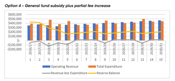
This option spreads the cost of the cemetery operations across the Shire and proposes a user pays model. It seeks a 100% subsidy of wages of $88k per annum from the general fund and proposes an increase of the cemetery maintenance fee from $420 to $550 or $130 overall increase of the cost of burials by 4%.
Legal /Policy
There is no legislative requirement for the development of a Cemetery Plan, however the need to develop a forward-thinking approach to manage the financial obligations, capacity and ongoing maintenance of cemeteries is a sensible approach and one that is supported by Cemeteries and Crematoria NSW (CCNSW), the State Government’s cemeteries body.
CCNSW commended Council for addressing the critical issue of the sustainability of cemeteries operated by Council and the potential changes which may occur in the future through, for example, the investigation by the Independent Pricing and Regulatory Tribunal (IPART) into interment costs and prices.
In accordance with the CCNSW – Voluntary Code of Practice for Cemetery Maintenance it is best practice to implement a strategic business plan to identify potential trends and costs of cemetery services, including the costs of these into the future and a financial model that provides for the apportionment of costs for current services as well as for perpetual costs over the long term – a long term financial plan.
Impacts on Strategic/Operational/Asset Management Plan/Risk
Strategic Alignment
The draft Cemetery Plan addresses the following goals in the Bega Valley Community Strategic Plan 2040 (CSP):
Goal 7: Our Shire continues to be a vibrant, enjoyable, safe and affordable place to live.
Goal 8 - Our places retain their character and scale, development is well planned, and a range of goods and services are available within our Shire that meet local needs.
Environment and Climate Change
There is no environment and climate change matters associated with the proposed exhibition of the draft Cemetery Plan.
Economic
Please refer to the attached report from Councils Ordinary Meeting of 16 December 2020 for economic information relevant to this report.
Risk
Please refer to the attached report from Councils Ordinary Meeting of 16 December 2020 for risk information relevant to this report.
Social / Cultural
Please refer to the attached report from Councils Ordinary Meeting of 16 December 2020 for social/cultural information relevant to this report.
Attachments
1⇩. Final BVSC Cemetery Plan 2020 - 2030
2⇩. Cemetery Plan feedback summary
3⇩. Response from CCNSW on Draft Cemetery Plan
4⇩. Council Report dated 16 December 2020 - Cemetery Strategy 2020-2030
|
21 April 2021 |
|
|
Item 11.1 - Attachment 4 |
Council Report dated 16 December 2020 - Cemetery Strategy 2020-2030 |
|
Item 11.2 |
11.2. RFT 2021-93, Barclay Street, Eden Sportsground Pavilion
This report details the recommendation to Council in relation to the evaluation of Request for Tender 2021-93 for the new Barclay Street Eden Sportsground Pavilion.
Director Assets and Operations
1. That Council accept the recommendations outlined in the Confidential attachment.
2. That authority is delegated to the General Manager to execute all necessary documentation in relation to The Request for Tender 2021-93.
3. That the tenderers be advised of Council’s decision.
Executive Summary
To progress the delivery of the new sportsground pavilion at Barclay Street, Eden, initially funded under Round 2 of the Stronger Country Communities Fund (SCCF), endorsement is sought to award the contract as recommended following the Request for Tender (RFT) 2021-93 process for the new pavilion project works.
The Request for Tender (RFT) is a result of extensive negotiations and consultation with the Barclay Street Sportsground Committee. These were complicated and prolonged due to the Black Summer Bushfires and responding to subsequent community requests and submissions that consideration be given to introducing evacuation centre type facilities to the pavilion as the Barclay Street sportsground, which served as a de-facto emergency evacuation site during the bushfires.
Grandstand seating and upgraded floodlighting to the Barclay Street site were also part of the SCCF-2 funding deed, these elements have already been delivered at the site.
Background
The proposed new sportsground pavilion at Barclay Street Eden has been in progress for some time, with the initial project development based on an ‘asset renewal and improvement’ of the existing facilities. During the early consultation and design development (pre bushfires), the scope increased notably, including a sizeable clubroom space and expanded facilities.
The location of the pavilion was subject to a Council resolution on 28 August 2019, where Council noted and endorsed the consultation and site selection process for the location of the new pavilion to be in the north eastern area of the Barclay Street sportsground site. Following this, Council Officers worked with Brent Dunne Design and the Barclay Street Sportsground Committee to reach a final concept design. This final concept design was reported to Council on 19 February 2020.
The Black Summer Bushfires made a significant and tragic impact between the writing of the concept design report and 19 February 2020 Council Meeting, when the concept recommendation was on the agenda for endorsement. As a result of the impact of the bushfires and subsequent Eden community submissions, the report referred to above included the below commentary for consideration with the concept design submission to Council.
“The Barclay Street site offers significant open space for self-sufficient evacuees and, with the right combination of amenities and facilities, would have the ability to cater for both self-sufficient evacuees as well as those that need a higher level of support.
Since the Barclay site has been utilised as an informal evacuation centre, Council has already been approached by members of the Barclay Site Committee with respect to modifying the design concepts for the site to support it becoming dual purpose as an evacuation centre. With relatively minor modifications to design concepts, it would be feasible to develop a multi-purpose facility that would meet the needs of site users as well as being adaptable as an evacuation centre in times of need. Proposed design modifications would include an increase in open space within a building as well as additional showers and toilets.
It is proposed that Council approach the NSW Government to ascertain the potential for either a funding variation to the existing Stronger Country Communities Fund grant or alternatively to seek additional funding sources that may be available to support future disaster resilience.”
Council resolved the following at the Council Meeting on 19 February 2020:
1. That Council receive and note the information in the report.
2. That Council endorse, in principle, the concept design for the new Barclay Street sportsground pavilion and request the designer to include a cost-effective element within the existing project budget that reflects the design planned for the Eden Welcome Centre.
3. That Council write to the NSW Government seeking an additional contribution towards the project to develop the site to a standard suitable for use as a future emergency evacuation centre.
4. That Council delegate authority to the General Manager, if required, to endorse amendments to the design to accommodate an emergency evacuation centre and to fit within the project budget.
The designer engaged to assist with the development of this facility, Brent Dunne Design, has addressed the second item listed above by including large, 200mm x 200mm timber feature posts, a timber soffit to the deck area at the front of the building, to include a timber architectural element that complements Eden’s Welcome Centre.
With respect to the third recommendation, Council Officers and the Barclay Street Sportsground Committee members did pursue additional funding with some success. This enabled the inclusion of some elements in the RFT scope to develop the site to a standard suitable for use as a future emergency evacuation centre, itemised as per Table 1 below. The sources of the additional funding being contributed to the project are as per the table in the Financial and Resource Considerations section of this report. NSW/ACT AFL had originally nominated a $50,000 contribution to the project also, however this was withdrawn as a result of the COVID-19 financial impact on the AFL.
Councillors should note, the Eden Killer Whale Soccer Club was fortunate to receive a substantial grant from Club Infrastructure Grants in March 2020 to upgrade their clubrooms, this upgraded facility will provide additional amenities to the Barclay Street site during an emergency event.
|
Additional Items included in Scope |
|
|
Item |
Specifics |
|
Extra amenities |
Provide two extra showers to the dressing rooms and a unisex accessible compliant bathroom (shower and toilet) to the club space area. Note: No changes to external public WCs, which will stand at three unisex ambulant and one unisex disabled. |
|
Increased Communications Capabilities |
· Comms/internet ports · PA System · Large projector screen · TV Monitor |
|
Electrical |
Meter board provision for the facility to be powered by diesel generator in the event of mains power supply failure. |
|
Kitchen |
This has been upgraded to a commercial level kitchen to be enable the preparation and service of larger volume meal delivery: · Large stove and oven · Dedicated hotplate grill · Commercial range hood · Stainless steel benches and sink with commercial level tapware. · Handwash basin as required for commercial service. · Welded seam vinyl flooring and coved skirting. · Bucket trap floor wastes. · Extra GPOs for additional cooking appliances/preparation needs. · Commercial type dishwasher · Commercial type microwave oven |
|
Increased services |
Provide external water, power and sewer points to enable connection of portable amenities blocks should the need arise. |
Table 1: Elements included to provide some operational emergency evacuation centre capabilities.
With the development of the Barclay Street Sportsground Pavilion and floodlighting, Council have been fortunate to receive funding for other developments within this sporting precinct. The Australian Government have funded the design and construction of an all-inclusive play-space ($400,000) as well as partly funding a skatepark ($300,000) within the sporting precinct, alongside the NSW Government’s Stronger Country Communities Fund contribution of $325,000.
The development of this funding led Council to develop a Masterplan for the Barclay Street Sportsground Precinct. Council endorsed the Barclay Street Sportsground Masterplan in August 2020. Council lodged two additional funding applications to combine the various funded elements together, to align with the overall Masterplan design. The overall project presents as a comprehensive, integrated project rather than a series of separate elements. One was an Everyone Can Play application for $300,000, which was successful, with the announcement made 12 March 2021, the other is a Bushfire Local Economic Recovery (BLER) Funding application for $450,000, the BLER funding announcements are due from April 2021.
Following the above outlined design development and subsequent tender documentation preparation process, the Barclay Street Pavilion RFT 2021-93 was issued to the marketplace via Vendor Panel on 3 March 2021 and closed on 31 March 2021, notification via Bega Valley Shire Council (BVSC) Communications was also carried out. There were two conforming tenders which were subject to the tender evaluation process, with submissions assessed against the following criteria:
|
Tender Criteria |
|
|
Criteria |
Weighting |
|
Overall project cost |
60%
|
|
Lump sum price breakdown |
|
|
Schedule of rates for variations |
|
|
Proposed construction arrangements, including site establishments and traffic management plan |
5% |
|
Construction program |
12% |
|
Recognition of local outcomes, demonstration of support for local business and community enterprise |
5% |
|
Support of Indigenous business development, provision of opportunities for Indigenous Australians to participate in the economy |
3% |
|
Experience completing similar projects & references |
5% |
|
Work health and safety, quality and environmental management qualifications& experience |
5% |
|
Demonstrated capacity to undertake a project of this scale |
5% |
|
Total |
100% |
Options
The options available to council are:
1. Accept the current tendered price for the pavilion works and allocate further funding to meet the current project budget shortfall.
2. That Council decline to accept the submitted tenders under Clause 178 of the Local Government (General) Regulation 2005 and action the Officers Recommendation items 2 and 3 above with a view to ultimately entering into a contract for the Barclay St. Pavilion upgrade.
Community and Stakeholder Engagement
Engagement undertaken
Community and Stakeholder engagement has been extensive and ongoing with monthly meetings held with the Sportsground Committee and Council officers. This formed the basis for continued community consultation to help progress the project, to provide input from the respective user groups and raise any issues they see are in the best interests of the project. In addition to the meetings, project design development correspondence has been a key part of the process to ensure the Committee are involved and the design progresses in a collaborative manner. The design and scope of works as issued for the RFT is a result of this extensive consultation process.
Further to the monthly meetings, a broad community information session was held at the Eden Fishermen’s Club on 6 August 2020 to present various Eden based BVSC projects, of which the Barclay Street Pavilion was one, and invited community comment. The Barclay Street project was received positively at this session.
Engagement planned
The Committee is an active and committed group and it is planned for the monthly meetings to continue through the project delivery stages until completion and handover of the project.
Financial and Resource Considerations
As mentioned in the Background section above, Council has been fortunate to receive additional funding for the project, as nominated in table below.
|
Item |
$ Excl GST |
|
Expenditure Detail |
|
|
Floodlighting - design, supply and install of floodlights to upgrade existing assets |
162,384.00 |
|
Grandstands - supply and install two grandstand seats (5 tier, 6m length) |
|
|
Other project costs- Consultants to design stage: REF, structural, hydraulic, kitchen design, Section J report etc BVSC PM & other associated project miscellaneous costs |
90,880.00 |
|
Barclay Street Sports Facility – construction of new sports facility including, change rooms and accompanying amenities, kiosk, public toilets, storage room and all abilities access |
Confidential
|
|
Total Expenditure |
Confidential |
|
|
|
|
Source of Funds |
|
|
Stronger Country Communities Fund - Round 2 |
653,948.00 |
|
BVSC Contribution Committee |
185,052.00 |
|
Eden Whalers - grant funded lights contribution |
10,000.00 |
|
Newscorp - PA system funding |
10,000.00 |
|
Business Council of Australia - Biz Rebuild, for upgrade to commercial kitchen |
50,000.00 |
|
Wentworthville Leagues Club |
170,000.00 |
|
Total income available |
$1,079,000.00 |
|
Less project expenditure and other project funding commitments for completion |
-253,264.00 |
|
Total Available Construction Funding |
825,736.00 |
|
Project Funding Shortfall |
Confidential |
Financial Option Impacts | Life Cycle Costing
|
Ongoing Financial Impacts |
$ Excl GST |
|
Capital Investment | Renewal, Upgrade, New |
825,736.00 |
|
Annual maintenance and operational costs |
8,711.00 |
|
Depreciation costs for 30-year life of asset |
17,873.00 |
|
User charges (annual income) |
2,163.00 |
Legal /Policy
The Barclay Street Sportsground is Council owned property, being Lot 9 DP 848111, which is classified as ‘community’ land under Section 31 of the Local Government Act 1993 (LG Act) and categorised as ‘sportsground’ under Section 36 of the LG Act. There is no Native Title or Aboriginal Land Claims over Council owned land. It is zoned RE1-Public Recreation under Council’s Local Environment Plan 2013 (CLEP 2013).
Planning approvals regarding development of recreation facilities are often addressed under Division 12, Parks and other Public Reserves of State Environmental Planning Policy (Infrastructure) (ISEPP 2007). The new pavilion is regarded as a development permitted without consent under the ISEPP 2007, Section 65 Development permitted without consent provisions.
Impacts on Strategic/Operational/Asset Management Plan/Risk
Strategic Alignment
Upgrading the Barclay Street, Eden facilities is part of the BVSC Delivery Program 2017-2021, Operational Plan 2019-2020 and is specifically listed in the Leisure and Recreation Asset Management Plan 2017.
Extracts from BVSC 2017-2021 Delivery Program and 2017-2018 Operational Plan:
CSP 2040 Goal 2: We are an active, healthy community with access to good quality recreation and sporting facilities, and medical health care.
CSP 2040 Goal 11: We are an informed and engaged community with a transparent, consultative and responsive Council.
CSP 2040 Goal 12: Our Council is financially sustainable, and services and facilities meet community need.
Extract from Leisure and Recreation Asset Management Plan, 2017:
What we will do:
Council plans to provide leisure and recreation services for the following:
· Operation, maintenance, renewal and upgrade of sporting facilities, playgrounds and skate parks, parkland areas, natural areas, aquatic facilities and minor maritime facilities to meet service levels set by Council in annual budgets within the 10-year planning period.
Key focus – what are the key items of focus for sporting facilities in the coming years
· Improving playing surfaces across all Council owned or managed assets
· Implementing Bega and Pambula Sporting Complex Master Plans
· Upgrading facilities at the Barclay Street Sports Complex
Environment and Climate Change
A Review of Environmental Factors (REF) has been compiled for the site. The building site presents no ecological or biodiversity issues as it is located within an existing carpark.
While the new pavilion is larger with more amenities, increased energy and water use will be minimised as the new pavilion and amenities replace two existing separate facilities, (the existing pavilion and an existing public toilet block, both to be demolished). The new facilities will have energy efficient LED lighting and water saving amenities. The building has also been designed to meet Section J requirements for BCA compliance in relation to thermal properties and energy consumption.
Economic
The new pavilion will benefit the local community, with funding approved for an all-inclusive play space, a new skatepark, the Eden Soccer Club upgrade, additional Everyone Can Play funding for the site and with Aslings Beach across the road, the aim is to make the Barclay Street Sportsground a recreation destination for Eden with the pavilion complementing the greater masterplan for the site.
With the growth in Eden Port tourism activities and other BVSC planned tourism focused projects in this area, the Barclay Street destination is a great tie in for the economic benefits that the increased tourism activity will provide.
Risk
The main risk for Council is delivering the project works within budget. Value Engineering (VE) by removing or reducing some elements from the project will be required to deliver the project within budget.
Social / Cultural
The new pavilion will provide a vastly improved amenity for the local community and visitors and hence provide for increased participation in recreational activities at the site. The improved facilities will encourage and provide for the growing mixed gender participation in sport in Eden and the region and the improved clubroom space will give the various clubs a focal point for club social activities.
The evacuation centre focused elements will serve to provide the community and visitors a place of refuge in future emergency situations. These same facilities will provide the capabilities to host larger scale community type events and festivals which will benefit the broader Eden community.
Attachments
1. Confidential attachment to Report RFT 2021-93 Barclay Street, Eden Sportsground Pavilion (Confidential - As this attachment contains information that would, if disclosed, confer a commercial advantage on a person with whom the Council is conducting (or proposes to conduct) business as per Section 10A(2)(c) of the Local Government Act 1993.
Although the above relates more explicitly to the discussion of closed business, it also forms part of the basis of justification as to why information relied upon in informing the public decisions made by Council are kept confidential. To consider this confidential material in open Council would be, on balance, contrary to the public interest (as defined in Section 14 of Government Information Public Access (GIPA) Act 2009) as it would potentially disclose private business information provided by tenderers in a confidential tender process and would also impact Council’s position in relation to its consideration, therefore impacting the tender process. This meets the requirements of Sect 10 D of the Local Government Act 1993 if Council were to close the meeting to discuss the details of individual tenderers.
|
Council 21 April 2021 |
Item 11.3 |
11.3. Road closure - Barclay Street, Eden sports precinct
Council approval is being sought to commence the road closure assessment process under Division 3 of the Roads Act 1993 (NSW) to enable works associated with the Barclay Street, Eden Sports Precinct Masterplan to progress.
Director Assets and Operations
1. That Council approve, in principle, the closure of the Council public road reserve within and adjoining the Eden Sports Precinct located on lot 1 DP 603701, lot 8 and 9 DP 848111.
2. That Council commence assessment of the road closure application under Division 3 of the Roads Act 1993 (NSW) and that the proposal be publicly advertised for a period of 28 days.
3. That if any objections are received, a further report be prepared for Council’s consideration.
4. That if no objections are received Council, by notice published in the Government Gazette, formally close the public road reserve concerned.
5. That the General Manager and Mayor be authorised to execute the necessary documentation to affect the road closure.
6. That all costs associated with the road closure process be borne by Council.
Executive Summary
A Masterplan for the Barclay Street, Eden Sportsground was adopted by Council on 5 August 2020 and to enable works to progress at the site the sections of unconstructed road corridor within the site need to be formally closed. Council approval is being sought to commence the road closure assessment process under Division 3 of the Roads Act 1993 (NSW) (Roads Act) to rectify this issue.
Background
To assist with planning and delivering necessary funded upgrades to the Barclay Street, Eden Sportsground Council staff progressed with the preparation of a Masterplan to capture each separate element of the recreational space to plan for a cohesive and workable space for all to enjoy. Council resolved, at its Ordinary Meeting of 5 August 2020, when considering the Masterplan for the Barclay Street Sportsground Precinct as follows:
1. That Council receive and note the information in the report.
2. That Council endorse the Draft Master Plan for the Barclay Street, Eden Sportsground Precinct.
3. That Council delegate authority to the General Manager, if required, to review and revise this Master Plan for any minor amendments arising during the delivery of this plan.
This Masterplan document sets out an exciting recreational and sporting precinct for Barclay Street to build on the original funding received by the NSW Government under Round 2 of the Stronger Country Communities Fund for the redevelopment of the sports pavilion, floodlighting and seating around the sportsground.
Since this original funding was received in December 2018, Council received additional funding for the development of an all-inclusive play space of $400,000 under the Community Development Grants Programme (Department of Infrastructure, Transport, Regional development and Communications).
Further funding has been provided for an upgraded skatepark in the value of $600,000 ($300,000 funded under Round 3 of the Stronger Country Communities Fund and $300,000 under the Building Better Regions Fund).
Recently, Council received a further $300,000 under the 2020-21 Everyone Can Play grant program to complement the play space and skate park projects so that these ultimately connect and provide an improved visitor experience with the inclusion of accessible park furniture, pathways, fencing around the site and other all-inclusive parkland/play elements.
Council has also applied for funding under the Bushfire Local Economic Recovery Fund for $450,000 to assist in developing the site to cater for emergency events and to assist with development of accessibility within and around the recreational precinct.
As shown on the below diagram there are sections of unconstructed road corridor which are being proposed for closure to enable the attached Masterplan works to progress.
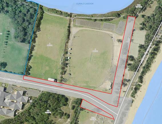
Council officers conducted a road status search which identified the road corridor as Council road. To finalise this process Council now intends to exercise its power pursuant to Part 4 Division 3 of the Roads Act to close the Council public road required to support the development of the site.
Options
The options available to Council are:
1. Council approve the proposal to formally close the sections of Council public road corridor within and adjoining the Eden Sports Precinct located on lot 1 DP 603701, lot 8 and 9 DP 848111 to support the development of the site; OR
2. Council does not approve the road closure. Noting the intention under the adopted Masterplan to progress construction within sections of the sections of unconstructed road reserve.
Community and Stakeholder Engagement
Engagement undertaken
Council officers have liaised with Crown Lands regarding the unconstructed sections of road corridor and following a status investigation it has been determined the subject road is under Bega Valley Shire Council’s control and management as per Gazette notice dated 7 October 1932 Folio 3693.
Engagement planned
Under section 38B of the Roads Act, notification of the proposal to close a Council public road must be published on Council’s website and be given to all owners of land adjoining the road, and all notifiable authorities as prescribed by the Regulations.
The notice must identify the road that is proposed to be closed and must state that any person is entitled to make submissions to the Council with respect to the closing of the road and must indicate the way and the period (being at least 28 days) within which, any such submission should be made.
Financial and Resource Considerations
All costs associated with the road closure process be borne by Council. Veris have provided Council officers with a quote of $4,600 to carry out the necessary survey work and registration of the Plan at NSW Land Registry Service and there will be a subdivision application fee applicable off $659 as well as legal costs associated with creation of the title. The project is being funded as follows:
|
Item |
$ Excl GST |
|
Source of Funds |
|
|
Pavilion and floodlighting |
$653,948 – SCCF Round 2 – Deed executed Dec 2018 |
|
All-inclusive play space |
$400,000 – CDG – Deed executed Dec 2020 |
|
Skatepark |
$300,000 – SCCF Round 3 – Deed executed Dec
2020; |
|
Site Connectivity – Everyone Can Play |
$300,000 – ECP – Deed to be executed |
|
Accessibility and Emergency |
$450,000 - Awaiting outcome of funding submission |
|
Total income available |
$2,403,948.00 |
|
Total Project Capital Cost |
$2,588,948.00 |
|
Total Available Construction Funding |
$2,588,948.00 |
|
Project Funding Shortfall |
$185,000 (Council contribution) |
Legal /Policy
If consent is granted to the proposed road closing, Council's Property officers will complete the road closure assessment process under Division 3 of the Road Act and by notice published in the Government Gazette, formally close the section of public road reserve. A plan of first title creation will be prepared and registered at Land Registry Services, with title transferred to Council.
Impacts on Strategic/Operational/Asset Management Plan/Risk
Strategic Alignment
The projects to deliver the funded projects at Barclay Street Sportsground site are included in the adopted 2020/21 operational plan and are also included in the ‘Sporting Projects and Playground and Skatepark’ maps within the 2020/21 Operational Plan.
The Operational Plan states that we will ‘deliver successful 2020 - 21 grant projects for sporting facilities, coastal accessibility, playground and boating infrastructure’.
Environment and Climate Change
There is no environment and climate change matters associated with the proposed road closure that have not already been addressed as part of the Masterplan.
Economic
There is no economic matters associated with the proposed road closure that have not already been addressed as part of the Masterplan.
Risk
There are several risks outlined in the attached report of 5 August 2020 in relation to funding requirements and project delivery.
Social / Cultural
There are no social / cultural matters associated with the proposed road closure that have not already been considered as part of the Masterplan.
Attachments
1⇩. Council report dated 5 August 2020 Barclay Street, Eden Sportsground Masterplan
2⇩. Eden Sports Masterplan
|
Council |
21 April 2021 |
|
Item 11.3 - Attachment 1 |
Council report dated 5 August 2020 Barclay Street, Eden Sportsground Masterplan |
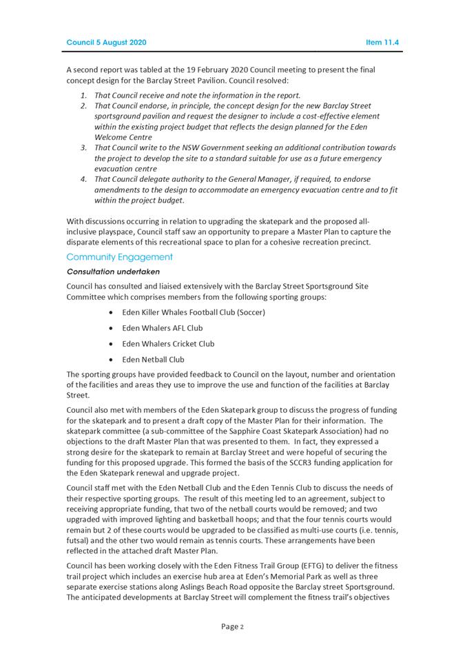
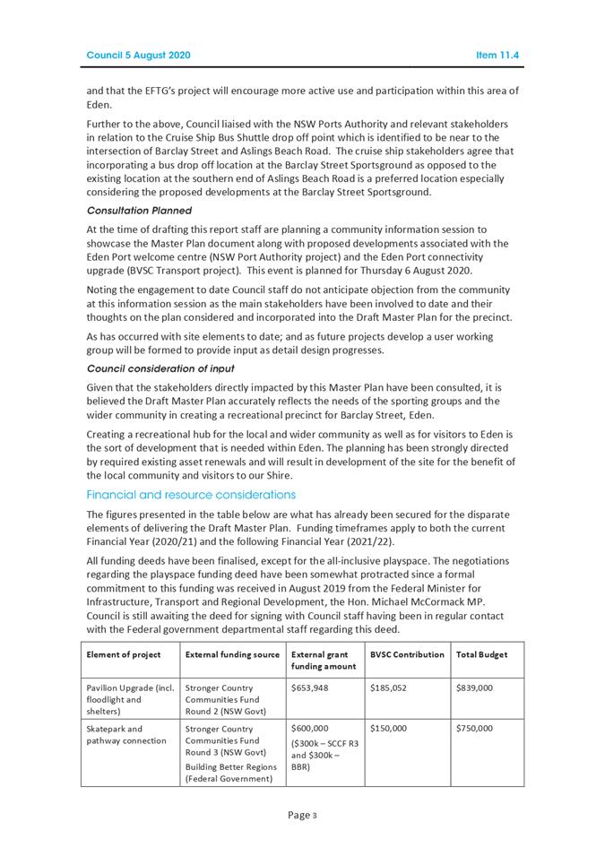
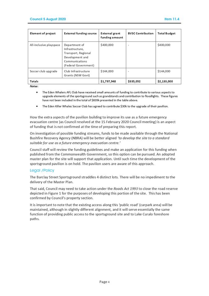
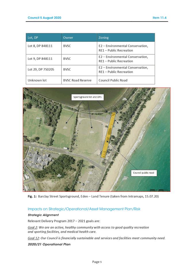
|
Council 21 April 2021 |
Item 11.4 |
11.4. RFT 2021-20 Equipment Hire (Plant & Trucks) Panel
This report details the recommendation to Council in relation to the evaluation of Tender 2021-20, for the establishment of a Panel of preferred contractors for the provision of externally hired equipment, with and without operators.
Director Assets and Operations
1. That Council accept the recommendations outlined in the Confidential attachment
2. That Council accept all compliant tenders received in relation to the services described in RFT 2021-20 Equipment Hire (Plant & Trucks) Panel
3. That Council delegate the General Manager with the authority to execute all necessary documentation
4. That tenderers are advised of Council’s decision
Executive Summary
To continue to support works outside the capability of Council owned equipment, Council must engage contractors for use of short-term hire of equipment, with and without operators, to meet the operational delivery of maintenance and capital works programs.
Background
Council has historically leveraged Transport for NSW (TfNSW) Hire of Earthmoving Equipment (Plant & Trucks) contract for short-term hire of equipment, with and without operators, to support delivery of the Assets & Operations directorate’s capital and maintenance programs. External equipment hire occurs where it’s outside of the capability of Council owned equipment.
TfNSW provided notice that the agreement would cease, effective December 2020, to align with their contract renewal process as well as a restructure of their equipment hire section which resulted in the central equipment hire section’s office being relocated from Bega to Wollongong.
Establishment of an in-house service that has clear sight of the Council owned fleet utilisation and the additional external requirements to deliver operations and projects, allows for a more streamlined and efficient delivery model for short term-hire arrangements.
The Tender was released via council’s eProcurement platform, VendorPanel, on Tuesday 9 February 2021 and closed Wednesday 10 March 2021 with a total of 49 submissions received.
All submissions were evaluated in accordance with Section 1, Clause 1.16.3 Evaluation Criteria of the Tender:
|
Criteria |
|
Conformity with the RFT requirements |
|
Equipment Specifications – including classification, make, model, year, rates, registration, serial and Attachments |
|
Demonstrated experience and capability |
|
Compliance with WH&S, quality and environmental management requirements |
|
Compliance with minimum insurance requirements |
|
Compliance with Chain of Responsibility requirements |
Options
The Contract will commence from the date of the Letter of Acceptance and expire 28 September 2022. The Contract includes two (2) optional twelve (12) month extensions.
Community and Stakeholder Engagement
Not required.
Engagement undertaken
Contractors engaged by council via TfNSW’s Hire of Earthmoving Equipment (Plant & Trucks) contract were initially informed in October 2020 of council’s intent to conduct its own competitive tender process.
Further contact occurred in January and February 2021, that provided an indicative timeframe of events and interim hire arrangements to ensure the continuation of external equipment hire services.
Engagement planned
No further formal engagement is planned however there will be continued communication with panel members to ensure details of equipment availability and rates are kept up to date.
Financial and Resource Considerations
Expenditure relating to the use of equipment is considered and budgeted in the project and associated budget planning process.
Legal /Policy
This Tender process was undertaken in accordance with Section 55 of the Local Government Act 1993 and Part 7 of the Local Government (General) Regulations 2005.
Impacts on Strategic/Operational/Asset Management Plan/Risk
Strategic Alignment
Internal Strategy Fleet Facilities - External Plant Hire Proposal and Work Plan.
Environment and Climate Change
The utilisation of a robust external hire panel reduces the need for council to have a large and potentially underutilised fleet that is not cost effective and consumes limited resources in maintenance and idle time on site.
Economic
Prior to engagement of external equipment, applicable contractors are assessed on various factors, including local benefit for locally owned and operated equipment.
Risk
Establishment of an in-house external equipment hire service enables the continuation of support for the delivery of the Assets & Operations directorate’s capital and maintenance programs where it’s outside of the capability of council’s owned equipment.
Social / Cultural
Insert Text here"
Attachments
1. Confidential Attachment to Council Report RFT 2021-20 Equipment Hire (Plant & Trucks) Panel (Confidential - As this attachment contains information that would, if disclosed, confer a commercial advantage on a person with whom the Council is conducting (or proposes to conduct) business as per Section 10A(2)(c) of the Local Government Act 1993.
Although the above relates more explicitly to the discussion of closed business, it also forms part of the basis of justification as to why information relied upon in informing the public decisions made by Council are kept confidential. To consider this confidential material in open Council would be, on balance, contrary to the public interest (as defined in Section 14 of Government Information Public Access (GIPA) Act 2009) as it would potentially disclose private business information provided by tenderers in a confidential tender process and would also impact Council’s position in relation to its consideration, therefore impacting the tender process. This meets the requirements of Sect 10 D of the Local Government Act 1993 if Council were to close the meeting to discuss the details of individual tenderers.
|
Council 21 April 2021 |
Item 11.5 |
11.5. Blackfellows Lake Boat Ramp
This report provides project background and further considerations following an onsite community meeting at Blackfellows Lake Boat Ramp on Tuesday 23 February 2021 and recommendations on options moving forward.
Director Assets and Operations
1. The report and attachments be received and noted
2. Subject to receipt of required permits and external funding being sourced Council proceed with adding a pontoon and shoreline access to the Blackfellows Lake Boat Ramp project
Executive Summary
The Blackfellows Lake Boat Ramp project was one of a package of three boating facility upgrades being delivered under the second round of Transport for NSW’s “Boating Now” program, with funding co-contributions from Transport for NSW and Bega Valley Shire Council. The other two projects being renewal and upgrades to the Quarantine Bay Pontoon and the Bermagui River Boat Ramp.
Prior to the project, Blackfellows Lake Boat ramp was an unformed facility which provided access to Blackfellows Lake and the Bega River. It is approximately 7km upstream of the Mogareeka Boat Ramp. It is a ‘local’ level facility in terms of asset hierarchy. It receives lower levels of use by comparison to other boat ramps in the shire. There are no other recreation assets at the site and there are no plans to add assets at present. Prior to the project there was no formal boating infrastructure or parking and a gravel access road. The project scope included formalising the boat ramp, establishing a pontoon / jetty, road works to and associated parking.
Background
The Council report 11.10 NSW Boating Now, Round 2 Projects – Concept Consultations 7 August 2019 provided a summary of the project, the consultation process and outcomes and recommendations to move forward. Council resolved:
1. That Council endorse the outcomes of the completed community consultation process.
2. That Council notes the General Manager, or her delegate, will proceed with detailed design development incorporating, where practical, those constructive suggestion tabled throughout the community consultation process and summarised in the report to Council.
Following the Council resolution, the project progressed through the following stages.
· Project detail design for construction was completed in April 2020.
· Project construction procurement undertaken.
· The results of the procurement were reported to Council on 24 June 2020.
· Permits and approvals were finalised on construction documents.
· Construction commenced on site in October 2020.
· The boat ramp and fixed jetty elements were completed prior to Christmas 2020.
· Significant work to the entry road is included in the project. (Programming of that work is related to the outcome from this report.)
In January 2021 correspondence was received by Council on the Blackfellows Lake Boat Ramp project particularly in regard to:
· Impractical and limited accessibility for those with limited mobility
· Difficulty in accessing and use of the fixed jetty at lower tides
· Impacts the project has had for those wishing to access the lake shoreline such as kayakers.
As a result of this feedback a memo providing project information was provided to Councillors 27 January 2021 (attached). Council considered a Notice of Motion at the Council meeting on 27 January 2021 and resolved:
1. That Council arrange a public meeting as soon as possible to allow concerned residents to provide feedback on the operation of the new jetty and boat ramp recently completed at Kalaru.
2. That Councillors workshop possible solutions to any identified problems with the new facility.
3. That a further report be provided to the Council with options to fix any problems identified.
4. That Council workshop establishment of processes of improved consideration of design for significant Council projects.
The public meeting was arranged and held on 23 February 2021.
Options
Blackfellows Lake issues and options recommendations table attached.
Community and Stakeholder Engagement
Consultation has taken place.
Engagement undertaken
Overview and outcomes of consultation for the project was included in reports to Council on 7 August 2019 and 24 June 2020. The consultation included:
· Use of Council's “Have Your Say” web page for online consultation program.
· Signs were also erected on sites to inform site users.
· ‘Site drop-in session’ was on Saturday 22 June 2019. A summary of the drop-in sessions was included in the Council News 2 July 2019.
The Boating Now Round 2 consultation process was included with a projects slide in an Access and Inclusion Advisory Committee (AIAC) presentation on 5 August 2019. The AIAC were advised the Boating Now Round 2 Project – Concept Consultations Report was included in the agenda for 7 August 2019 Council meeting and was available for review on Council’s website.
Despite the process above the project outcomes have fallen short of local community expectations. A review of the consultation and engagement specific to the Blackfellows Lake Boat Ramp has been undertaken, and found:
· The community consultation was undertaken in mid-2019. Council consultation and engagement process have continued to develop since.
· Project Control Group (PCG): A PCG is a group of representatives of specific interest and user groups with a direct relationship or interest in the project. They typically include local clubs or known user groups. The PCG groups are of use in discussing and balancing different user needs, site issues and design considerations of a project. At the time PCG’s were being utilised typically for ‘regional’ asset projects; they were not formed for all projects. A PCG was not established for the Blackfellows Lake Boat Ramp project. It is now more common to form, work with and inform PCG’s of progress throughout a project. The process of working with PCG’s is relatively new and is continuing to be reviewed and developed. For example, a recent staff meeting flagged better consistency in providing updates to PCG’s as a project progresses through key project phases.
· Access Inclusion Advisory Committee Project Representation: At the time of the Blackfellows Lake Boat Ramp consultation the process of an AIAC project representative was developing. At the time project updates were being given at AIAC meetings (quarterly) however AIAC member ‘project’ representation had not yet been established (it was an item in the agenda of the 5 August 2019 AIAC meeting). Since then a particular AIAC rep is nominated for each AIAC project of interest. This person is then included in the Project Control Group. However, as noted above there was not a PCG formed for the Blackfellows Lake site.
As a result of the Council resolution 27 January 2021 a public meeting was arranged and held on site on 23 February 2021. The meeting was well attended with approximately 40 people present. Councillors Fitzpatrick and Nadin attended.
An overview of the project to date, including site constraints, and relevant design requirements was provided by the Director Assets and Operations. An overview of some options and ideas for improvements was also given at the site meeting. It was noted there were some differing ideas and priorities discussed amongst the group. Assessment of options discussed is included in the options table attached.
People were encouraged to provide further feedback and comments through Council’s general email address.
Engagement planned
An update on the project will be provided to those people that have written to Council. Information will also be provided through Council News / Media release and distributing through local Kalaru community communications.
Financial and Resource Considerations
At the time of drafting the recommended improvements are unfunded. The intention is to ideally utilise funds that will become available as costs are confirmed for projects being delivered through external funding programs (e.g. LRCIF). Council has also applied to NSW Maritime for additional funding to contribute to the works.
|
Item |
$ Excl GST |
|
Expenditure Detail |
|
|
Floating Pontoon Estimate |
$140000k |
|
Access to Shoreline – Pathway (Preferred approx. 25m) |
$7500 |
|
Access to Shoreline - Fixed Ramp – Alternate (approx. 8m) |
$60000 |
|
Total Expenditure |
$147,500 - $207,500 |
|
|
|
|
Source of Funds |
|
|
Redistribution Boating Now R2 funds |
$20,000 |
|
|
|
|
<reserve funds|name of reserve |
|
|
Total income required |
$147,500 - $207,500 |
|
|
|
|
Total Project Capital Cost |
$147,500 - $207,500 |
|
Total Available Construction Funding |
$20,000 |
|
Project Funding Shortfall |
$127,500 - $187,500 |
Financial Option Impacts | Life Cycle Costing
|
Ongoing Financial Impacts |
$ Excl GST |
|
Upgrade, New |
$147,500 - $207,500 |
|
Annual maintenance and operational costs |
$500 |
|
Depreciation costs |
$4800 - $6,600 |
|
User charges (annual income) |
0 |
Managing the project budget continues to be important. Any additions to the project will not proceed until adequate external funding is sourced.Legal /Policy
Planning and Approvals: A Review of Environmental Factors (REF) was carried out during project development. The REF did not identify any high-risk items at the location but did identify the need for management and permits in regard to sensitive cultural and wetland areas. Potential environmental risks during construction – primarily erosion and sediment control – will be addressed in the appointed contractor’s Construction Environmental Management Plan (CEMP).
Permits for the current works were provided by NSW Department of Primary Industries (DPI) and Office of Environment and Heritage (Aboriginal Heritage Impact Permit). An application for an amended DPI permit will be required to gain approvals for the recommended additional works, particularly any vegetation removal.
The adopted BVSC Leisure and Recreation Policy 1.08 encourages development of fit for purpose, well used assets that ‘provide access and enable people to enjoy the environment we live in’.
Impacts on Strategic/Operational/Asset Management Plan/Risk
Strategic Alignment
The Blackfellows Lake Boat Ramp upgrade project has links to strategic documents as follows:
BVSC Maritime Infrastructure Plan –The scope of work identified for Blackfellows Lake includes upgrade and widening of the launching area and access road, upgrade of the boat ramp to a reinforced concrete ramp and installation of a jetty.
NSW Government Maritime Infrastructure Plan 2019-2024 – includes enabling great recreational and tourism experiences on our waterways, enabling safe access and use of NSW waterways.
BVSC Community Strategic Plan 2021 Goal 2: We are an active, healthy community with access to good quality recreation and sporting facilities, and medical health care
BVSC Infrastructure Prospectus – Projects improving marine infrastructure is a headline project in the Prospectus. Upgrades will align with the key outcomes of quality infrastructure and safety.
Recreation Asset Management Plan – The additional items will be upgrades to the facility creating additional items to be managed by Council moving forward. When completed it will be added to Councils asset register and it will be included in the marine infrastructure management program.
Environment and Climate Change
Environmental permits have been obtained for works to date. An updated DPI Fisheries permit will be required for additional works.
There is a flood risk at the site. It is likely that flood events may become more frequent as a result of climate change. Risk associated with flooding impacts on a floating pontoon is discussed below.
Economic
Provision of quality infrastructure directly aligns with the marine infrastructure component of BVSC’s Infrastructure Prospectus; the Prospectus supports NSW’s target to double overnight visitor expenditure and acknowledges the relationship between quality recreational infrastructure, tourism and the local economy.
Risk
Flooding is a known risk at the site. This is identified in BVSC Floodplain Management Plans. This was identified in the initial design work for the project. This is the reason why a fixed jetty structure was recommended for the project by the design consultants (as opposed to a floating pontoon). There is increased risk flooding may impact on a pontoon structure.
During flood events water levels increase in Blackfellows Lake water flows remain relatively mild. There are measures that can be designed into to pontoon that mitigate impacts on the structure from flood water. These include designing relatively tall piles, the design allowing the pontoon to ‘float’ off the piles in high floods and anchoring the pontoon to keep it from floating down stream in high water flood events. If the pontoon does float off the piles it will need to be reinstalled which may require specialised cranes and equipment and will affect use of the facility until it is reinstalled.
For reference the recent flood event is considered close to a 10% Average Exceedance Probability (AEP) event (sometimes referred to as a 1 in 10-year event). The water height within Blackfellows ‘Lagoon’ was approximately 4m AHD. The proposed pontoon concept allows for a top of pile level of approximately 6.0-6.5m AHD. This is designed for the 10% AEP probability event (predicted water level 6.5m AHD). It is estimated there would have been 1.5-2m ‘free pile’ during the recent event. If water levels rose a further 1.5-2m the pontoon would have floated off its piles. It should be noted that the main arm of the Bega River peaked at 7.38m AHD. The flood height in Blackfellows Lagoon is influenced by the local bathymetry and vegetation at the time of flooding. These change over time and can alter localised flooding levels. The attached document Flooding March 2021 includes images of the recent flood event at the site for reference.
The proposed pontoon concept piles could be lengthened by up to 4m. An additional 2m would provide 0.5-1m ‘free pile’ in the 5% AEP (1:20 year; 7.3m AHD) event. An additional 4m would provide 0.5m free pile in the 1% AEP (1:100 year; 9.1m AHD.) Cost increases with each option. The impact on amenity also increases, as the taller piles become more noticeable in the surrounding environment.
While this risk is noted it needs to be considered in terms of the benefit and improved use opportunities a pontoon will add to the facility against the likelihood and impacts of a high-water flood event. In noting the benefits and risk it is considered the risk can be mitigated and managed to an acceptable level.
Social / Cultural
The Blackfellows Lake boat ramp site is culturally significant from both Aboriginal and European archaeological perspectives. Local archaeological consultancy Lantern Heritage were engaged to investigate the site; subsequent reports include an Aboriginal Cultural Heritage Assessment Report (ACHAR) and a Historical Archaeology Report. These reports informed and supported applications for an Aboriginal Heritage Impact Permit (AHIP) and a Section 139(4) Exception, both of which have been granted by the NSW Department of Planning, Industry & Office of Environment and Heritage.
Attachments
1⇩. Blackfellows Lake Boat Ramp and Jetty March 2021 Flood
2⇩. Blackfellows Lake Pontoon concept February 2021
3⇩. Blackfellows Lake issues and options recommendations table
|
Council |
21 April 2021 |
|
Item 11.5 - Attachment 1 |
Blackfellows Lake Boat Ramp and Jetty March 2021 Flood |
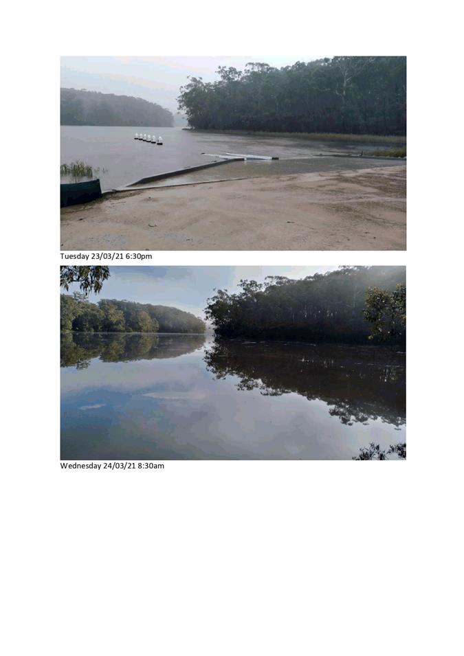
|
Council |
21 April 2021 |
|
Item 11.5 - Attachment 3 |
Blackfellows Lake issues and options recommendations table |
|
Council 21 April 2021 |
Item 11.6 |
This report recommends Council adopt the recommendations of the Bega Valley Local Traffic Committee.
Director Assets and Operations
That Council adopt the recommendations of the Bega Valley Local Traffic Committee minutes dated 31 March 2021 to be tabled at the 21 April 2021 Council meeting.
Upper Cobargo Road be temporarily closed between 8.00am and 5.00pm on Saturday, 12 June 2021 for the duration of a competitive stage of the Bega Valley Rally.
Coopers Gully Road be temporarily closed between 8.00am and 5.00pm on Saturday, 12 June 2021 for the duration of a competitive stage of the Bega Valley Rally.
Walls Flat and Wents Road be temporarily closed between 11.30am and 4.30pm on Saturday, 12 June 2021 for the duration of a competitive stage of the Bega Valley Rally.
Buckajo Road, Spring Creek Road be temporarily closed between 11.00pm and 4.30pm on Saturday, 12 June 2021 for the duration of a competitive stage of the Bega Valley Rally.
Niagra Lane / Comans Lane be temporarily closed between 12.30pm and 4.30pm on Saturday, 12 June 2021 for the duration of a competitive stage of the Bega Valley Rally.
Pericoe Road be temporarily closed between 5.45am and 10.00pm on Saturday, 12 June 2021 for the duration of a competitive stage of the Bega Valley Rally.
Snake Track be temporarily closed between 5.45am and 10.00pm on Saturday, 12 June 2021 for the duration of a competitive stage of the Bega Valley Rally.
That persons involved in the preparation and implementation of the Traffic Control Plan must hold the appropriate NSW RMS accreditation.
That organisers fully implement an approved Special Event Transport Management Plan.
That organisers have approved public liability insurance of at least $20 million indemnifying Bega Valley Shire Council, NSW Police and NSW Roads and Maritime Services by name for the event.
That organisers obtain approval from the Commissioner of NSW Police or their delegate, under Section 115 of the Road Transport Act 2013, prior to conducting the event.
That signage be displayed advising of Road Closures.
That the event operates strictly under the NSW Health Department COVID19 conditions.
A copy of the submission is in link below:
https://begavalley.nsw.gov.au/page.asp?f=RES-DCV-40-33-15
Council have received the following request from Club Bega:
“The board of directors have asked me to contact the committee to request some signage for “No Parking” at the entrance of the club.
On too many occasions, the manoeuvring in and out of the bus is problematic as cars are parked at the wide entrance. (please see marked up photo in the below link).
On the marked up photo is the sort of signage I believe is required to direct attention to those who park in this area.”
Council’s LTC representative has visited the site and has observed vehicles parking within close proximity of the access to the front of the Club and it’s adjoining accessible car spaces. He has also telephoned the Club Manager who has indicated they would like to see some pavement markings. However, as was explained to the Manager, signs are a more visual reminder and do not need to be repainted after a bitumen reseal takes place. The LTC Council representative has made the following recommendation.
Council approve the installation of a “No Stopping” zone commencing at a point 50 metres from the eastern intersection point of Gipps Street and Bega Street for a length of 24 metres.
Link below to photos:
https://begavalley.nsw.gov.au/page.asp?f=RES-QKJ-24-18-80
Executive Summary
The Local Traffic Committee is primarily a technical review committee and is not a Committee of Council. Local Traffic Committees operate under delegation from NSW Roads and Maritime Services (RMS) who are responsible for traffic control on all New South Wales roads. Their role is to advise Council on traffic control matters that relate to prescribed traffic control devices or traffic control facilities for which Council has delegated authority.
It is a requirement for Council to formally adopt the recommendations from this Committee prior to action being taken.
Nil
|
Council 21 April 2021 |
Item 11.7 |
11.7. Pambula Sporting Complex Pavilion Concept Design
This report provides an update on the progress to the Pambula Sporting Complex Pavilion project and proposes a final concept plan for Council endorsement to progress with the project.
Director Assets and Operations
1. That Council receive and note the information in the report.
2. That Council endorse in principle the concept design for the new Pambula Sporting Complex Pavilion building.
3. That Council delegate authority to the General Manager, to endorse amendments to the design as recommended by the Project Control Group to deliver best outcomes in balancing user needs, building function and the project budget
Executive Summary
To progress the delivery of the new sportsground pavilion at Pambula Sporting Complex, funded through the NSW Office of Sport Election Commitments Program the Project Control Group (PCG) and Council officers are seeking endorsement from Council for the final concept design for the pavilion building.
Engagement and consultation have been undertaken with the PCG in working toward the final concept design. This report outlines the consultation process and how it has resulted in broad support for the final concept design.
Background
A report was presented to the Ordinary Council meeting of 4 April 2020 titled “Sporting Complex Upgrade Projects Update”. The report considered three sporting complex projects with the Pambula Sporting Complex being one of those projects. Council resolved:
1. The report be received and noted.
2. The membership structure of the Project Control Groups detailed in the report be endorsed by Council.
3. The measures to move forward with the projects outlined in the report be endorsed by Council.
4. That project milestone reports be distributed to Councillors.
5. That Council delegate authority to the General Manager to consider recommendations of Project Control Groups and provide direction to progress with projects.
Funding of $4m is available through the NSW Office of Sport Election Commitments Program to deliver projects identified in the adopted Pambula Sporting Complex Master Plan.
Provision of a new sports pavilion will be a valuable asset to the local community. It will replace the two existing pavilion buildings on the site being the current Sports Clubs Pavilion and the Frank Maher Pavilion. Both buildings do not meet current design standards and have issues with adequate facility prevision particularly in regard to mixed gender use and accessibility and are generally below an acceptable standard, particularly as the site is considered a regional facility within Council’s adopted Recreation Asset Management Plan 2017.
Following the resolution, Council officers have been working with the Pambula Sporting Complex PCG. A preliminary pavilion concept design was initially developed by local designer Richie McNeil based on information provided by the Pambula Sporting Complex Site Committee. That information included current reference documents for sports facilities planning and design such as Sport and Recreation Victoria Sport Infrastructure Guidelines. The initial concept was used to source baseline information, particularly regarding cost estimates and requests for information on a modular building option. This design has subsequently been developed and refined over the past two months resulting in the attached final draft concept plan. Ongoing consultation with the PCG further refined and developed the concept design to its’ current form. The design has broad support from the PCG.
The existing sports club pavilion and amenities will be demolished to make way for the new building. The Frank Maher Pavilion will be used as temporary facilities during the construction and will be demolished once the new building is opened. By the time construction commences it is expected the Multiuse / Squash Indoor Courts at Sapphire Aquatic Centre will be complete and available for use.
Options
The main options available to Council are:
1. Endorse the attached final concept design enabling the project to progress through planning approvals, detailed design and construction tendering.
2. Endorse the attached final concept design, with any identified amendments to be made, enabling the project to progress through planning approvals, detailed design and construction tendering.
3. Not endorse the final concept design, noting this will impact on the project delivery program.
Community and Stakeholder Engagement
Extensive community engagement with groups and stakeholders has taken place.
Engagement undertaken
Consultation was an important aspect in the development of the Master Plans for the Bega Valley Regional Sporting Facilities, (Pambula and Bega). This consultation included extensive community engagement with groups and stakeholders, covered varied interests and demographics and acknowledged the benefit and value of multi-purpose facilities which can offer a wide range of uses and participation opportunities; from local matches to large scale regional events. There has also been consultation with peak sporting bodies and State Government agencies in the development of the Master Plans for Bega and Pambula. Project awareness in development of the Sporting Complex Master Plans was promoted through press releases, local newspapers, sportsground committees, social media and local radio.
Since the 4 April 2020 Council meeting, regular meetings have been held with the PCG and Council officers. The PCG includes representatives of the main user groups and site committee, Councillors, BVSC Access and Inclusion Committee and the NSW Office Of Sport. This has formed the basis for more direct consultation and collaboration on specifics and facilities and layout of the building in particular; and has resulted in development of eight concept designs, with the attached receiving endorsement from the PCG.
Engagement planned
Whilst the building plan concept design is complete there will continue to be items to be resolved as the work progresses through planning approvals and detailed tender documents. An example of this is the roof type which will consider appearance, function, engineering, build efficiency and ongoing maintenance. It is planned for the regular meetings to continue through the project design and delivery stages until completion. The PCG will provide feedback options as design progresses and make recommendations for amendments if required. (As per Officers Recommendation 3).
Council will continue to collaborate with the NSW Office of Sport, particularly in providing a project ‘stage gate’ report to define the deliverables and milestones under the funding agreement; now the scope of the major element of the project (being the pavilion building) has been defined and costed.
Financial and Resource Considerations
The Pambula Sporting Complex Master Plan is funded by the NSW Government under the NSW Office of Sport Election Commitments Program. The total funding for the project is $4m. The focus of this report is the pavilion building with is the major element in the project. Estimated cost of the preliminary building concept was $3.3m. While the concept has evolved since the preliminary concept including some efficiencies in layout and floorspace this pricing has been used as the point of reference.
The remaining $700k will be available to progress with other items in the Pambula Sporting Complex Master Plan such as, vehicle and pedestrian access, parking, pathways, floodlighting, fencing and landscaping. These will be prioritised by the PCG and included in the Project Stage Gate report to the NSW Office of Sport to prioritise deliverables under the funding.
As the project involves asset renewals with the replacement of existing facilities (2x pavilions and the public amenities), it is not anticipated ongoing servicing costs will be affected by the new works.
|
Item |
$ Excl GST |
|
Expenditure Detail |
|
|
Pambula Sporting Complex Pavilion |
Estimate $3.3m |
|
Other elements identified in the Pambula Sporting Complex Masterplan |
$700k |
|
|
|
|
Total Expenditure |
$4m (sum of all costs) |
|
|
|
|
Source of Funds |
|
|
<approved budget|revenue funded> |
|
|
NSW Office Of Sport Election Commitments Program. |
$4m |
|
<reserve funds|name of reserve |
|
|
Total income available |
$4m |
|
|
|
|
Total Project Capital Cost |
$4m |
|
Total Available Construction Funding |
$4m |
|
Project Funding Shortfall |
$0m |
Financial Option Impacts | Life Cycle Costing
|
Ongoing Financial Impacts |
$ Excl GST |
||||||||||||||||||
|
Capital Investment | Upgrade |
$3.3m |
||||||||||||||||||
|
Annual maintenance and operational costs |
$15K |
||||||||||||||||||
|
Depreciation costs
|
$73k |
||||||||||||||||||
|
User charges (annual income 2019 reference) |
$3.3k |
Legal /Policy
Property Discerption: Pambula Sporting Complex is Lot: 449 DP: 720916 and is Council Managed Crown Land (BVSC Managed Crown Reserve # 98164 - Pambula Beach Sports Complex). It is zoned RE1-Public Recreation under Council’s Local Environment Plan 2013 (CLEP 2013).
Planning and Approvals: The works on the Pambula Sporting Complex site reflect the long-term use of the site are permitted within the RE1 zoning.
Planning approvals regarding development of recreation facilities are often addressed under Division 12, Parks and other Public Reserves of State Environmental Planning Policy (Infrastructure) (ISEPP 2007). The new pavilion may be regarded as a development permitted without consent under the ISEPP 2007. BVSC Planning will provide advice on the appropriate planning pathway. A development application will be submitted if required.
Native Title: As the site is Crown Land and includes construction of public works Council is required to notify and give the opportunity to comment to the South Coast People under Sections 24JB (6) of the Native Title Act 1993. In this regard notification was given on 6 August 2020 and the notification period expired on 3 September 2020. No comments were received.
Impacts on Strategic/Operational/Asset Management Plan/Risk
Strategic Alignment
Community Strategic Plan Goals related to the Pambula Sporting Complex Pavilion Building Project are:
Goal 2: We are an active, healthy community with access to good quality recreation and sporting facilities, and medical health care.
1.2.1: Plan and manage boating infrastructure, sporting grounds and facilities, parks and gardens, natural areas and public amenities
1.2.4: Construct recreation facilities, boating infrastructure, public toilets and sporting grounds and facilities.
Goal 3 Our Economy is prosperous, diverse and supported by innovative and creative business.
2.3.3: Advocate, support and deliver sustainable tourism and visitor experiences to maximise the benefit to the community
Goal 12: Our Council is financially sustainable, and services and facilities meet community need.
6.12.19: Deliver civil construction and infrastructure works for transport and recreation assets
2020/21 Operational Plan
1.2.4.2 Progress with detailed planning and approvals for the sports infrastructure projects at the Bega and Pambula Sporting Complexes
Taking a strategic approach and having Council adopted masterplans were an important part in attaining the significant external funding. The master planning process identified some clear provision gaps between existing assets and community needs and expectations. It also identified a number of opportunities for improved use principally through a multi-purpose approach to facilities.
Asset Management
Bega Valley Shire Council is committed to an asset management approach. The challenge in delivering asset renewals across the range and volume of assets in the Shire is known to Council and referred to in asset management plans.
Council has an adopted Recreation Asset Management Plan 2017 (RAMP). This plan puts a focus on renewing existing assets and/or linking capital upgrades and new assets to adopted Strategic Plans. The adopted Pambula Sporting Complex Masterplan includes elements and improvements linking to the renewal of existing assets.
The new pavilion building will replace three existing buildings on the site being the Sports Clubs Pavilion, The Frank Maher Pavilion and the public amenities building.
Environment and Climate Change
The building site presents no ecological or biodiversity issues as it is located within vicinity of the existing pavilion and amenities buildings.
Changes regarding energy and water use will be positive as the new pavilion and amenities will replace three existing separate facilities and include more modern energy efficient lighting and water saving amenities.
Projects related to improved stainability within the Pambula Sporting Complex Masterplan include utilising treated water for irrigation and energy efficient floodlighting. There will be opportunity for solar and renewable energy options in the future. A funding application was submitted for a combined project Pambula Sporting Complex & Aquatic Centre Lighting & Electrical Infrastructure Upgrades through the NSW Government Regional Sport Facility Fund.
Economic
Development and progressing the Sporting Complex Master Plans will increase tourism opportunities for the Bega Valley by increasing the ability to host regional sporting, community and cultural events. Events hosted at the Regional Sporting sites will stimulate economic benefit for the local community through visitor spend and stays.
Hosting of sporting events such as regional tournaments, state championships, pre-season competitions, demonstration games, training and development camps have benefits beyond the spend of participants. Sports events usually attract increased numbers due to the family-orientated nature, including parents and siblings of participants. In addition, first-time visitors are more inclined to return to the area for another visit after a positive experience in the Bega Valley.
Risk
Project Risk identification has been included in project briefs submitted to the NSW Office of Sport. They were included in the Council report 8 April 2020.
The main risks for Council are delivering the concept design and associated works within budget and within the project time frames.
Whilst a detailed preliminary project costing has been received, the actual cost will not be known until the Request for Tender (RFT) process for construction has run its course. If the outcome of the RFT process exceeds the budget the project may require value engineering (VE) by removing or reducing some elements from the project to deliver within budget. If need be these items will be worked through with the PCG and authorised by the General Manager (staff recommendation item 3).
A project program will be included with the Project Stage Gate Report to be provided to the NSW Office of Sport. It is noted that this is a Council election year and the timing of the Request for Tender process and subsequent report to Council may be impacted by the Council Caretaker Period.
Councillors will be aware that an RFT process is relatively lengthy and under Councils procurement policy requires reports to Council (needed to align report drafting and approvals with Council meeting dates) to receive direction on works valued over $250k. With Council elections in September in this instance the timing of that process will fall within The Council’s care-taker period which may inhibit Councils ability to accept a Tender and proceed with the project. This may result in a delay of months in accepting a tender and in turn delay commencement and the program of the works. To overcome this risk, and noting this project included in the adopted operational plan and adopted strategic plans, and that the project is externally funded, it is recommended that the Council delegate authority to the General Manager in consultation with the project control group, or negotiate with a suitably qualified tenderer, to deliver works based on the attached concept plan within the project budget.
Social / Cultural
There is no doubt that sport is an important part of life in regional areas. It provides opportunities for health and wellbeing and also much enjoyed social interaction for many in the community.
The new pavilion will provide a vastly improved amenity for the local community and visitors and hence provide for increased participation in recreational activities at the site. The improved facilities will encourage and provide for growing mixed gender participation in sport locally and the region and the improved club room space will give the various clubs a focal point for club and social activities.
The proposed redevelopments will considerably enhance the facilities enabling increased utilisation by sporting and community groups. The key opportunity is in taking a ‘multiple-use’ approach to see all grounds and facilities well used for a wide range of uses. While there is no doubt local clubs and current sporting codes are key user groups; the implementation will also see opportunities for other stakeholders and partners to become involved and benefit from the project.
Attachments
1⇩. Pambula Sporting Complex Concept Update - Ground Floor Plan
|
Council |
21 April 2021 |
|
Item 11.7 - Attachment 1 |
Pambula Sporting Complex Concept Update - Ground Floor Plan |
Council |
21 April 2021 |
12.1 Remote Attendance by Councillors at Council Meetings.................................. 480
|
Council 21 April 2021 |
Item 12.1 |
12.1. Remote Attendance by Councillors at Council Meetings
The Office of Local Government (OLG) have issued a Consultation Paper on Remote Attendance by Councillors at Council Meetings and are seeking submissions from Councils.
Director Business & Governance
That Council:
1) Prepare and lodge submission to the Office of Local Government by 3 May 2021
2) The submission will include the items ‘supported’ and ‘not supported’ as detailed in the report
3) additional input (if any) to be received from Councillors by 23 April 2021 to be included in the submission
Executive Summary
Temporary amendments were made to the Local Government Act 1993 in March 2020 in response to the COVID-19 pandemic allowing councillors to participate in meetings remotely by audio-visual link. The amendments allowing remote attendance expired on 25 March 2021.
Some Councils have called for the option of remote attendance to be made available to them on an ongoing basis to encourage greater diversity of representation.
The Government agrees that allowing remote attendance by councillors may serve to remove some of the impediments that currently prevent underrepresented groups from serving on their local councils.
The Government is therefore proposing to amend the Model Code of Meeting Practice for Local Councils in NSW (Model Meeting Code) to include non-mandatory provisions that allow councils to permit councillors to attend council and committee meetings remotely by audio-visual link in certain circumstances.
Due to insurmountable logistical and technological challenges for some councils the proposed new provisions will not be mandatory, and Councils can choose whether to include them in their adopted codes of meeting practice.
Background
This report highlights the key points for Council’s submission to the OLG Consultation Paper.
The key points to be included in Council’s submission are:
a) Support - permission of individual councillors to attend meetings remotely until 31 December 2021
· Councillors are to live or work in the area and should exercise their duties diligently
· Councillors are not permitted to attend meetings while at work
b) Support- approval for individual councillors to attend a meeting remotely by audio-visual link can be granted for the following reasons
· Ill health
· Disability
· Carer responsibilities
· Natural disaster
· Bullying and or sexual harassment /assault
c) Do not support - Approval requires five days’ notice to the general manager
Suggest this provision is three days’ notice
d) Do not support - Remote attendance for these reasons is limited to three occasions in each year
Suggest replace “three occasions” with “not more than 50% of meetings”; replace “year” with “calendar year”
e) Do not support - Remote attendance to be from a location within 100km of the NSW border.
This provision should be removed from the proposed amendments
f) Support - Reasonable consideration to be given to whether to grant a councillor’s request to attend a meeting by audio-visual link
g) Support - Failure to appropriately declare and manage conflicts of interest, observe confidentiality or comply with the council’s code of meeting practice on one or more occasions when they have attended a meeting by audio-visual link can result in refusal of further requests
h) Support - Rules and standards to apply to remote attendance:
i. Appropriate attire
ii. Minutes of the meeting to record remote attendance
iii. Pecuniary or conflict of interest from Councillor to ensure they are not able to see or hear or vote on the matter
iv. No other person in sight or able to hear the meeting
v. Chairperson permitted to mute the councillor’s audio link for the purpose of enforcing compliance with the council’s code of meeting practice.
Suggest adding that a professional background, and minimising of possible interruptions such as children, animals etc
Options
The recommendation of this report is that Council prepare a submission to the Office of Local Government as outlined above.
Community and Stakeholder Engagement
Engagement undertaken
The General Manager sought input from Councillors for inclusion in the submission to the OLG consultation paper. Feedback received will inform the submission.
In addition, feedback at the General Managers Meeting held by the Local Government Professionals in March 2021 has informed the proposed submission. With specific concern related to limiting the ability to maximise diversity of elected officials in local government when the use of technology can support participation.
Engagement planned
The submission will be lodged to the Office of Local Government by the due date; and it is expected that this will inform the review of the Model Code of Conduct and Model Code of Meeting Practice.
Financial and Resource Considerations
Procedure 6.02.4 Payment of expenses and provision of facilities for Councillors provides includes the following objectives:
The objectives of this procedure are to:
· enable the reasonable and appropriate reimbursement of expenses incurred by Councillors while undertaking their civic duties
· enable facilities of a reasonable and appropriate standard to be provided to Councillors to support them in undertaking their civic duties
· ensure accountability and transparency in reimbursement of expenses and provision of facilities to Councillors
· ensure facilities and expenses provided to Councillors meet community expectations
· support a diversity of representation
· fulfil the Council’s statutory responsibilities.
Annual budget allocations are prepared to assist Councillors fulfil the requirements of their role as an elected official. This would include the appropriate technology to attend meetings remotely.
Future investment in technology at the Bega Valley Shire Council Chambers will be required.
Legal /Policy
Local Government Act 1993
Local Government (General) Regulation 2005
Model Code of Meeting Practice for Local Councils in NSW
Code of Meeting Practice (6.02.2)
Code of Meeting Practice 6.02.2(a) Pandemic Amendments
Compliments and Complaints including UCCC (6.02.2)
Councillor certificates of service
Councillor Induction Guidelines OLG 2018 (6.02.3)
Elected Officials Communication Protocols
Payment of expenses/facilities for Councillors (6.02.4)
Record keeping requirements for Councillors
Registration of Gifts and Benefits (6.02.10)
Impacts on Strategic/Operational/Asset Management Plan/Risk
Strategic Alignment
6: Strong, Consultative Leadership
Goal 11 We are an informed and engaged community with a transparent, consultative and responsive
6.11.8: Develop and implement good governance systems
Environment and Climate Change
There are no direct environmental and climate change impacts associated with the recommendation of this report.
Economic
There are no economic impacts as a result of the recommendations of this report.
Risk
Remote attendance at Council meetings is an important mechanism to facilitate diverse participation in local government. This recommendation supports the Council making a submission to the Office of Local Government through a formal consultation process that maximises the ability for engagement with elected officials.
Social / Cultural
There are potentially negative social impacts if the proposed amendments to remote meetings is implemented as proposed. This is primarily the ability for elected officials to participate in meetings if constrained by prescriptive legislation.
Attachments
1⇩. Remote Attendance by Councilors Consultation Paper
|
Council |
21 April 2021 |
13.1 Certificate of Investment.................................................................................. 494
|
Council 21 April 2021 |
Item 13.1 |
13.1. Certificate of Investment
This report details Council’s cash and investments as at the end of March 2021.
Director Business & Governance
1. That Council receive and note the attached reports indicating Council’s investment position as at 31 March 2021.
2. That Council note the certification of the Responsible Accounting Officer.
Executive Summary
I, Judy Jordan, as the Responsible Accounting Officer of Bega Valley Shire Council (BVSC), hereby certify the investments listed in the attached reports have been made in accordance with Section 625 of the Local Government Act 1993 (the LG Act), clause 212 of the Local Government (General) Regulation 2005 and Council’s Investment Policy.
All investments have been appropriately recorded in Council’s financial records and reconciled monthly.
Background
Under the legislation and regulations mentioned below, the Responsible Accounting Officer must present to Council monthly, the status of the investments held by Council. The Responsible Accounting Officer must detail the investments held, and their compliance with both internal policy and external regulation under the Ministerial Order of Investments.
In accordance with the recommendations made by the Office of Local Government (OLG) Investment Policy Guidelines published in June 2010, the monthly Investments Reports are attached to the Council cash and investment report. This allows a stand-alone report to be published on Council’s website for the public to view without having to peruse the Council meeting agenda for the relevant meeting.
Options
This is a receive and note report and does not require consideration of options for decision.
Community and Stakeholder Engagement
Engagement undertaken
There is no community or stakeholder engagement associated with the recommendation of this report.
Engagement planned
Not applicable.
Financial and Resource Considerations
A list of Councils cash and Investments is detailed below.
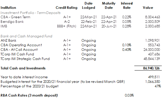
Council’s revised interest income budget is $1,066,350, income earned to date is $499,511 (47%). It is worth noting that the T-Corp Strategic Cash Fund had a negative result that has reduced Council’s investment income. Council will need to reduce its expected interest income in the March Quarterly Budget review to approximately $700,000.
Councils current investments currently exceed the RBA 3 monthly deposit average for the March 2021 of 0.03%
These funds can be broken into the following Funds:
|
Table 1: Investments by Fund $’000 |
|||
|
Fund |
Jan-2021 |
Feb-2021 |
Mar-2021 |
|
General Fund |
27,928 |
26,657 |
20,776 |
|
Water Fund |
22,444 |
22,809 |
23,969 |
|
Sewer Fund |
39,797 |
40,347 |
42,195 |
|
TOTAL |
90,169 |
89,813 |
86,940 |
Each Fund’s allocation can only be utilised on its specific operations. For example, Water Fund cannot use its financial resources on General Fund projects.
Included in the General Fund investments are amounts that are externally restricted for specific purposes, i.e. contributions and unspent grants. In addition, there are amounts that are internally restricted by Council. The following table provides details of all funds by restrictions:
|
Source of Funds |
Value |
|
Total cash and Investments |
$86,940,126 |
|
External Restrictions as at December QBRS |
$64,268,663 |
|
Internal Restrictions as at December QBRS |
$9,888,081 |
|
Unrestricted funds |
$12,783,382 |
Legal /Policy
Section 625 of the Local Government (LG) Act determines money may only be invested in a type of investment authorised by Order of the Minister for Local Government and published in the Local Government Gazette. The current Ministerial Order of Investment was published 17 February 2011.
Clause 212 of the Local Government (General) Regulation 2005 determines the Responsible Accounting Officer must provide Council with a written report setting out details of all money Council has invested under Section 625 of the LG Act.
The report must also include a Certificate as to whether the investments have been made in accordance with the LG Act, the Regulations and the Council’s Investment Policy.
Council has an Investment Policy published under Policy number 6.07. This Policy is reviewed every four years by Council and annually by Council officers.
Impacts on Strategic/Operational/Asset Management Plan/Risk
Strategic Alignment
6: Strong, Consultative Leadership
6.12: Our Council is financially sustainable and services and facilities meet community need
6.12.5: Improve the provision of corporate financial services
Environment and Climate Change
TCorp has provided BVSC with their Investment Stewardship Policy (attached to the report to Council report on 31 January 2018).
In order to deliver the best long-term risk adjusted returns for clients, TCorp integrates environmental, social and governance (ESG) factors into the investment processes of the appointed investment managers. TCorp will evaluate the ESG policies and practices of its investment managers as part of the manager selection process, as well as during periodic manager reviews.
Council revoked the Cash Management and Investment Strategy (6.07.3) on 25 November 2020. Our Finance team has commenced diversification in our investment options which is detailed in the body of the report presented.
Economic
Council’s investment policy objective is to maximise returns by investing with the most favourable rate of return. Performance of that investment is reported monthly, quarterly and annually.
Risk
Council policies have strict guidelines to reduce Councils risk to capital. Other legal instruments, such as the Ministerial Order referenced above, are used to mitigate financial risk.
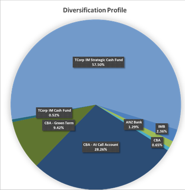
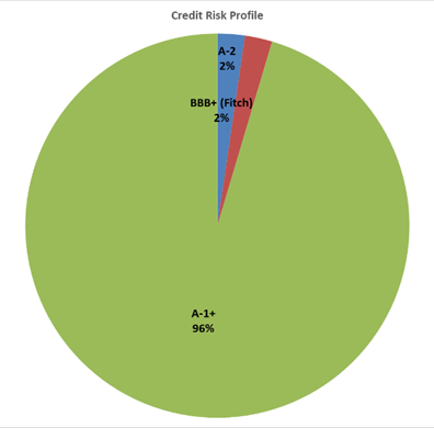
Social / Cultural
Maximising performance of returns enables the organisation to leverage additional funding received as a result of investments and use these towards community projects, programs and services.
Attachments
Nil
|
Council |
21 April 2021 |
Notices of Motion
21 April 2021
16.1 Naming of Bridge Road..................................................................................... 500
|
Council 21 April 2021 |
Item 16.1 |
16.1. Cr Cathy Griff - Naming of Bridge Road
That the Bega street named Jacksonia Grove revert to its original name of Bridge Street.
Background
Mr Peter Lacey presented to Council on 3rd March with a persuasive case to revert the name of a recently renamed street (Jacksonia Grove) to the original, historically significant name Bridge Street. The Council purports to value the Shire’s relatively scant remaining heritage. Ensuring restoration of the facade of the Hotel Australasia’s facade and plans to appoint a heritage consultant to the Cuttagee Bridge design are recent instances where respect has been shown to origins and traditions.
Mr Lacey explained the motivation for the name reversal as follows:
'Bridge Street is, historically, Bega's most important street. When Bega was surveyed back in 1854, Bridge Street was the base line from which all the rest of town was sited. It was deliberately given that name - it was the logical extension of Bridge Street in what is now North Bega, and the crossing place on the river joined both ends of Bridge Street. Indeed, from 1878 to 1898, the first bridge into Bega town bridged these two sections of Bridge Street.
That change of name from Bridge Street to Jacksonia Grove is an inappropriate choice of name for a street in this area and contravenes Standards Australia's stipulations relating to the use of 'Grove' in naming streets - is nothing short of local history vandalism...'
Cr Cathy Griff
Attachments
Nil
|
Council |
21 April 2021 |
Questions with Notice
21 April 2021
17.1 Cr Allen - Water Concerns – Brogo Supply........................................................ 502
17.2 Cr Allen - Water Concerns - Water Treatment Plant........................................ 503
|
Council 21 April 2021 |
Item 17.1 |
Question with Notice
Cr Allen asked for an update on the turbidity level in the Brogo Supply given the recent rain events and the cost of cartage of water.
Director Assets and Operations
Turbidity levels in Brogo River fluctuated significantly after the rain events at the end of March and was too high to supply to the system without treatment. Since then the river has returned to a turbidity of less than 2 NTU, which is very good. Council spent around $50k on carting water from Merimbula and Bega to avoid a boil water notice over the Easter holiday. Carting along with supply from Couria Creek and treatment of the water from the Brogo River through the temporary plant was a success.
Nil
|
Council 21 April 2021 |
Item 17.2 |
Question with Notice
Cr Allen asked for an update on the progress of our Water Treatment Plant projects, particularly Brogo and when and if the Illawambra Trunk Main is being upgraded.
Director Assets and Operations
The Brogo Water Treatment Plant (WTP) project has been successfully awarded to Laurie Curran Water. Design workshops have been held and detailed design is underway. Bega WTP reference design has been completed and the specifications for the tender are underway. Bega WTP workshop and accommodation has been advertised and submissions from contractors received. Yellow Pinch WTP site selection is underway.
Illawambra Trunk Main options are under assessment specifically with how to fund a smaller pipe for the purpose of domestic supply to replace the redundant and risky trunk main asset.