|
OrdinaryMeeting Notice and Agenda
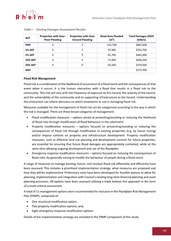
An Ordinary Meeting of the Bega Valley Shire Council will be held at Council Chambers, Biamanga Room Bega Valley Commemorative Civic Centre
Bega on
|
|
OrdinaryMeeting Notice and Agenda
An Ordinary Meeting of the Bega Valley Shire Council will be held at Council Chambers, Biamanga Room Bega Valley Commemorative Civic Centre
Bega on
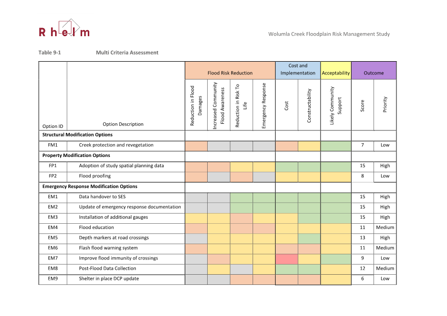
|
Council meetings are recorded and live streamed to the Internet for public viewing. By entering the Chambers during an open session of Council, you consent to your attendance and participation being recorded.
The recording will be archived and made available on Council’s website www.begavalley.nsw.gov.au. All care is taken to maintain your privacy; however as a visitor of the public gallery, your presence may be recorded.
The Agendas for Council Meetings and Council Reports for each meeting will be available to the public on Council’s website as close as possible to 5.00 pm on the Thursday prior to each Ordinary Meeting. A hard copy is also made available at the Bega Administration Building reception desk and on the day of the meeting, in the Council Chambers.
The Minutes of Council Meetings are available on Council's Website as close as possible to 5.00 pm on the Monday after the Meeting.
1. Please be aware that the recommendations in the Council Meeting Agenda are recommendations to the Council for consideration. They are not the resolutions (decisions) of Council.
2. Background for reports is provided by staff to the Chief Executive Officer for presentation to Council.
3. The Council may adopt these recommendations, amend the recommendations, determine a completely different course of action, or it may decline to pursue any course of action.
4. The decision of the Council becomes the resolution of the Council, and is recorded in the Minutes of that meeting.
5. The Minutes of each Council meeting are published in draft format, and are confirmed by Councillors, with amendments if necessary, at the next available Council Meeting.
If you require any further information or clarification regarding a report to Council, please contact Council’s Executive Assistant who can provide you with the appropriate contact details
Phone (02 6499 2222) or email execassist@begavalley.nsw.gov.au.
· Is the decision or conduct legal?
· Is it consistent with Government policy, Council’s objectives and Code of Conduct?
· What will the outcome be for you, your colleagues, the Council, anyone else?
· Does it raise a conflict of interest?
· Do you stand to gain personally at public expense?
· Can the decision be justified in terms of public interest?
· Would it withstand public scrutiny?
A conflict of interest is a clash between private interest and public duty. There are two types of conflict:
· Pecuniary – regulated by the Local Government Act 1993 and Office of Local Government
· Non-pecuniary – regulated by Codes of Conduct and policy. ICAC, Ombudsman, Office of Local Government (advice only). If declaring a Non-Pecuniary Conflict of Interest, Councillors can choose to either disclose and vote, disclose and not vote or leave the Chamber.
· Is it likely I could be influenced by personal interest in carrying out my public duty?
· Would a fair and reasonable person believe I could be so influenced?
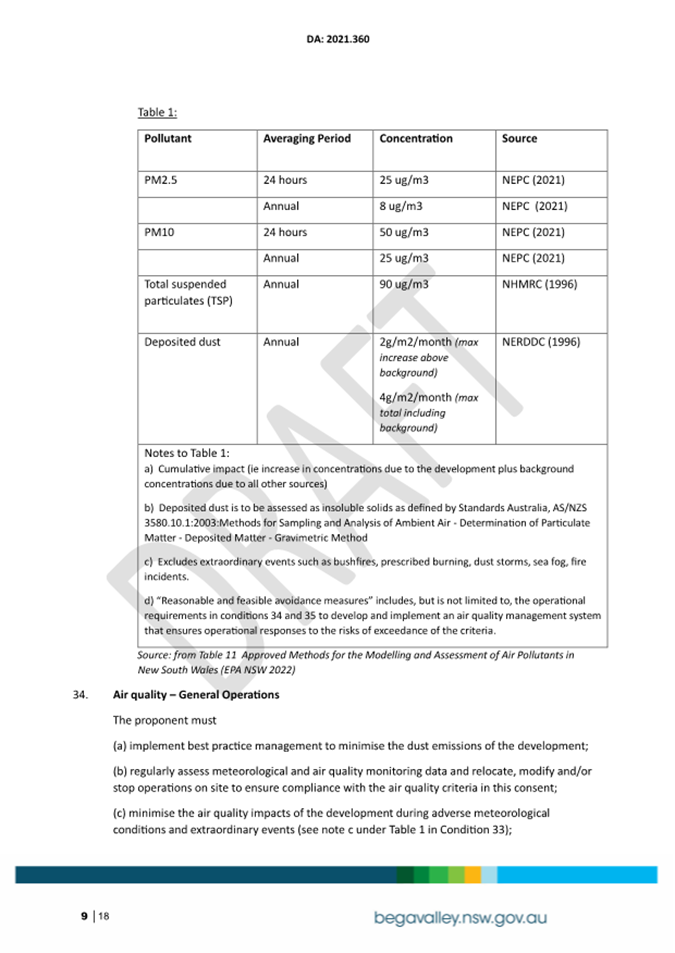
· Conflict of interest is closely tied to the layperson’s definition of ‘corruption’ – using public office for private gain.
· Important to consider public perceptions of whether you have a conflict of interest.
1st Do I have private interests affected by a matter I am officially involved in?
2nd Is my official role one of influence or perceived influence over the matter?
3rd Do my private interests conflict with my official role?
For more detailed definitions refer to Sections 442, 448 and 459 or the Local Government Act 1993 and Bega Valley Shire Council (and Model) Code of Conduct, Part 4 – conflict of interest.
Whilst seeking advice is generally useful, the ultimate decision rests with the person concerned.Officers of the following agencies are available during office hours to discuss the obligations placed on Councillors, officers and community committee members by various pieces of legislation, regulation and codes.
|
Contact |
Phone |
|
Website |
|
Bega Valley Shire Council |
(02) 6499 2222 |
council@begavalley.nsw.gov.au |
www.begavalley.nsw.gov.au |
|
ICAC |
8281 5999 Toll Free 1800 463 909 |
icac@icac.nsw.gov.au |
www.icac.nsw.gov.au |
|
Office of Local Government |
(02) 4428 4100 |
olg@olg.nsw.gov.au |
http://www.olg.nsw.gov.au/ |
|
NSW Ombudsman |
(02) 8286 1000 Toll Free 1800 451 524 |
nswombo@ombo.nsw.gov.au |
Under the provisions of Section 451(1) of the Local Government Act 1993 (pecuniary interests) and Part 4 of the Model Code of Conduct prescribed by the Local Government (Discipline) Regulation (conflict of interests) it is necessary for you to disclose the nature of the interest when making a disclosure of a pecuniary interest or a non-pecuniary conflict of interest at a meeting.
The following form should be completed and handed to the Chief Executive Officer as soon as practible once the interest is identified. Declarations are made at Item 3 of the Agenda: Declarations - Pecuniary, Non-Pecuniary and Political Donation Disclosures, and prior to each Item being discussed:
Council meeting held on __________(day) / ___________(month) /____________(year)
|
Item no & subject |
|
|
Pecuniary Interest
|
In my opinion, my interest is pecuniary and I am therefore required to take the action specified in section 451(2) of the Local Government Act 1993 and or any other action required by the Chief Executive Officer. |
|
Significant Non-pecuniary conflict of interest |
– In my opinion, my interest is non-pecuniary but significant. I am unable to remove the source of conflict. I am therefore required to treat the interest as if it were pecuniary and take the action specified in section 451(2) of the Local Government Act 1993. |
|
Non-pecuniary conflict of interest |
In my opinion, my interest is non-pecuniary and less than significant. I therefore make this declaration as I am required to do pursuant to clause 5.11 of Council’s Code of Conduct. However, I intend to continue to be involved with the matter. |
|
Nature of interest |
Be specific and include information such as : · The names of any person or organization with which you have a relationship · The nature of your relationship with the person or organization · The reason(s) why you consider the situation may (or may be perceived to) give rise to a conflict between your personal interests and your public duty as a Councillor. |
|
If Pecuniary |
Leave chamber |
|
If Non-pecuniary (tick one) |
Disclose & vote Disclose & not vote Leave chamber |
|
Reason for action proposed |
Clause 5.11 of Council’s Code of Conduct provides that if you determine that a non-pecuniary conflict of interest is less than significant and does not require further action, you must provide an explanation of why you consider that conflict does not require further action in the circumstances |
|
Print Name |
I disclose the above interest and acknowledge that I will take appropriate action as I have indicated above. |
|
Signed |
|
NB: Please complete a separate form for each Item on the Council Agenda on which you are declaring an interest.
|
22 April 2026 |
Statement of Ethical Obligations
Recommendation
That the Minutes of the Ordinary Meeting held on 25 March 2026 as circulated, be taken as read and confirmed.
Pecuniary, Non-Pecuniary and Political Donation Disclosures to be declared and tabled. Declarations also to be declared prior to discussion on each item.
6.1 Opposition to Crown Land Management Amendment (Statutory Review) Bill 2026.......... 8
8.1 Extractive Industry (gravel quarry), 1399 Sapphire Coast Drive, Wallagoot....................... 12
8.2 Affordable Housing Implemention Group review.................................................................. 129
9.1 Merimbula CBD Upgrade project- community consultation on proposed traffic, parking and public space changes........................................................................................................................... 135
9.2 Wolumla Floodplain Risk Management Study and Plan final findings............................... 155
9.3 Request for Tender (RFT) 2526-047 Supply & Install Guardrail - Multi Year Programme 394
9.4 Draft Playspace Improvement Plan.......................................................................................... 398
9.5 Bega Valley Local Transport Forum 17 March 2026.............................................................. 457
10.1 Acquisition of land for Bega Borefields.................................................................................... 466
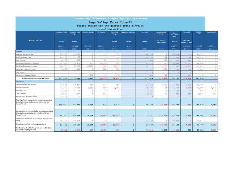
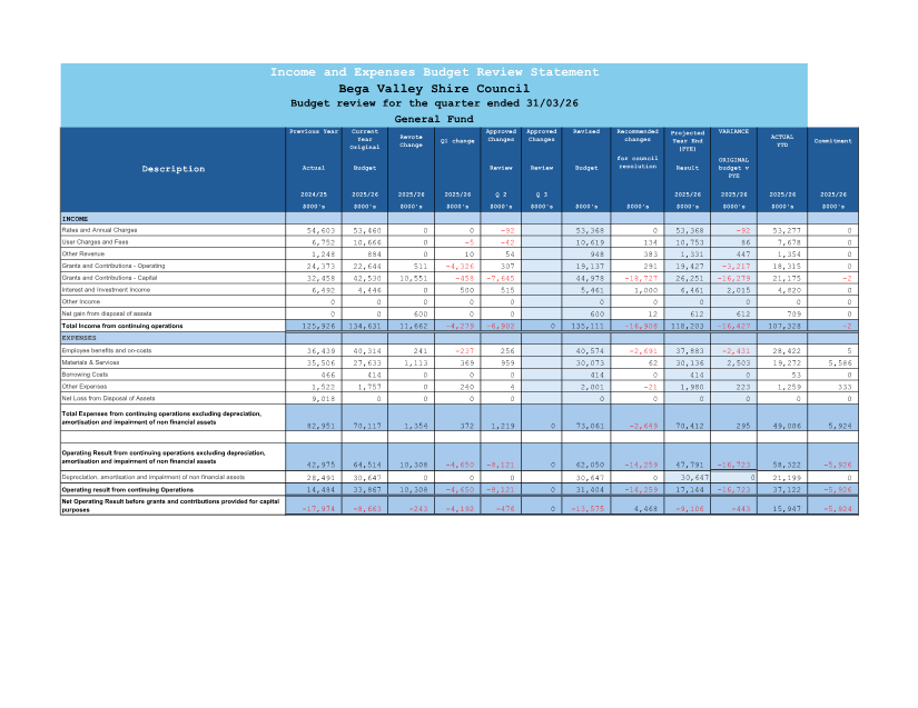
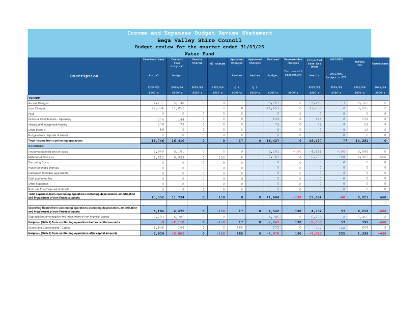
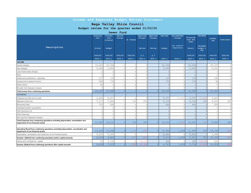
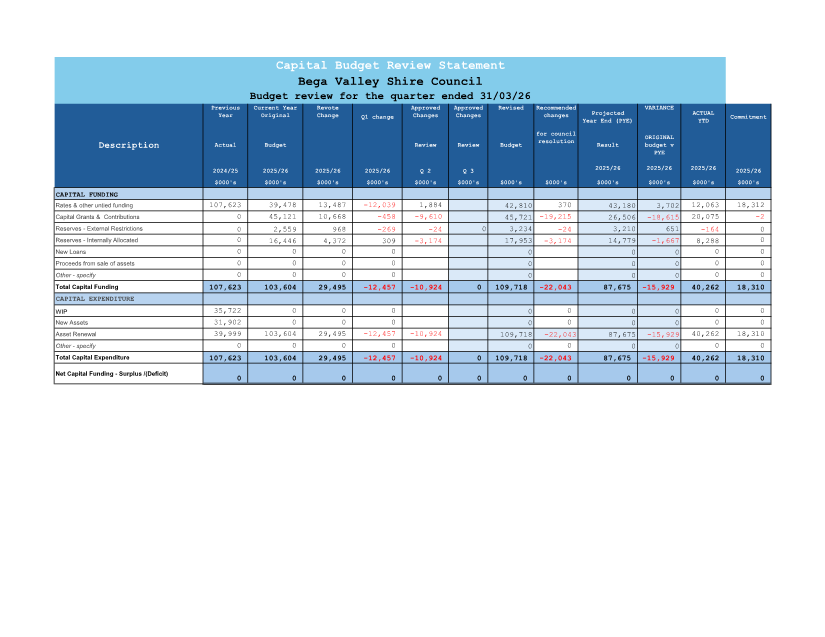
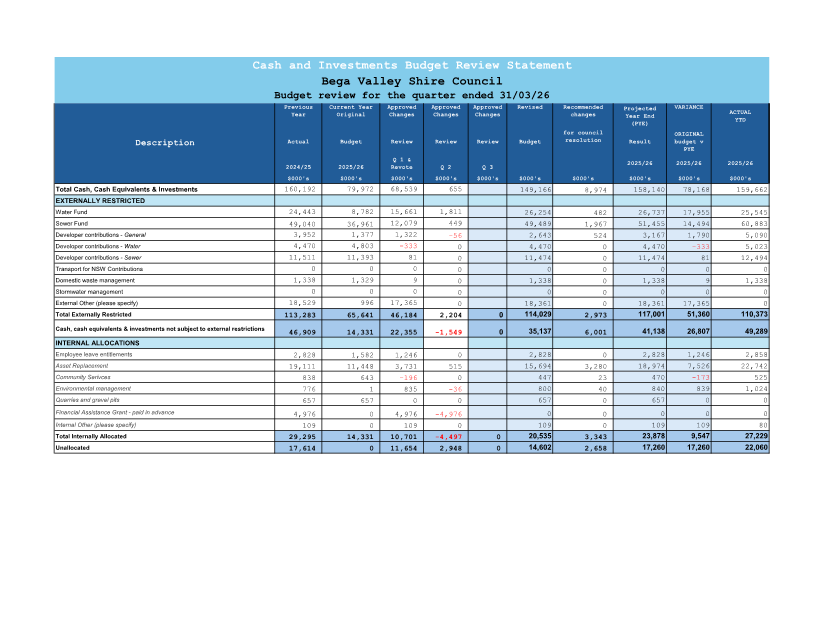
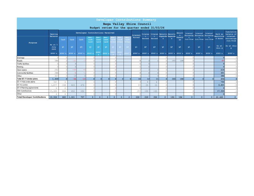
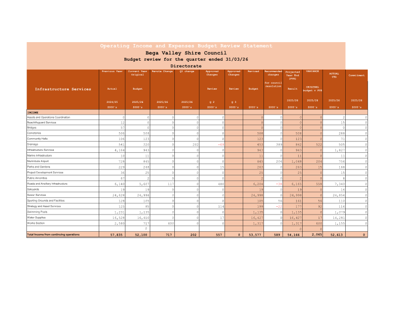
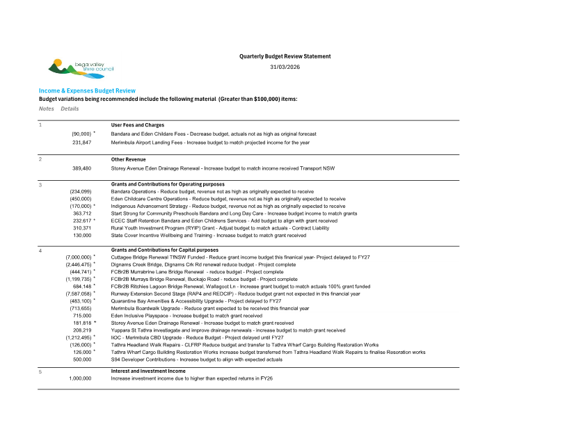
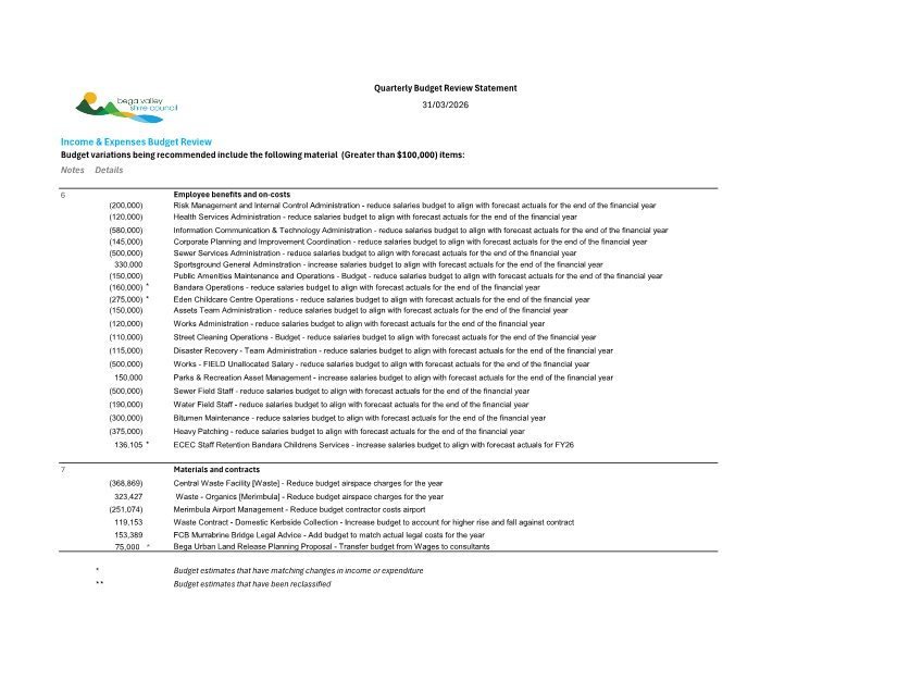
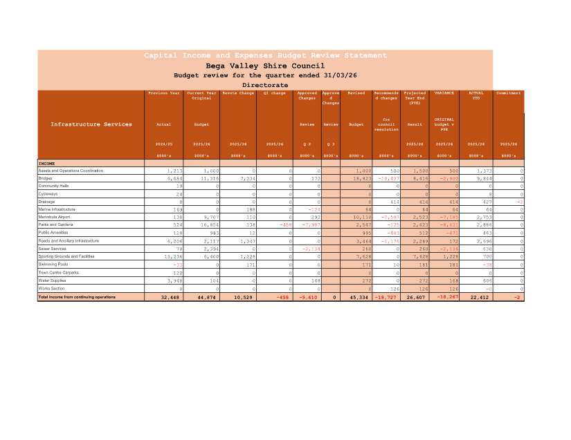
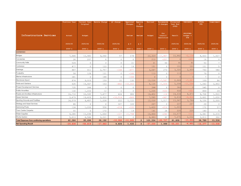
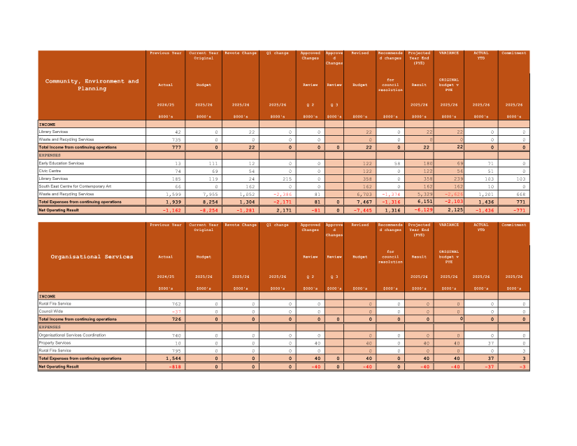
10.2 Quarterly Budget Review Statement (QBRS) March 2026 (Q3 Review)............................ 477
10.3 Certificate of Investment March 2026..................................................................................... 503
10.4 Waiver of water connection charge - Bega Town Band Building (Canning St, Bega)...... 510
12.1 Cr Daly - Community Connect Meeting - Tanja Hall.............................................................. 517
15.1 Cr Porter - Jellat Flats resurfacing............................................................................................. 519
16.1 Cr Fitzpatrick - Merimbula CBD parking................................................................................... 521
Representations by members of the public regarding closure of part of meeting
Adjournment Into Closed Session, exclusion of the media and public........................... 521
|
Council |
22 April 2026 |
Mayoral Minutes
22 April 2026
6.1 Opposition to Crown Land Management Amendment (Statutory Review) Bill 2026 8
|
Item 6.1 |
6.1. Opposition to Crown Land Management Amendment (Statutory Review) Bill 2026
Cr Russell Fitzpatrick
Recommendation
That Council:
1. Notes the introduction of the Crown Land Management Amendment (Statutory Review) Bill 2026, which proposes significant amendments to the Crown Land Management Act 2016 arising from the statutory review.
2. Notes with serious concern that the Bill:
· Enables the transfer of financial risk and legal liability from the State Government to local councils.
· Provides for the retrospective transfer of native title compensation liabilities and civil liabilities.
· Expands Ministerial powers to direct councils and impose obligations without adequate consultation.
· Introduces additional reporting, compliance and administrative requirements.
· Has been developed with an absence of genuine consultation with local government, despite direct and significant impacts.
3. Recognises that the Bill enables:
· The automatic transfer of assets, rights and liabilities associated with Crown land management to councils in certain circumstances.
· Increased Ministerial direction and intervention powers, including performance directions and compliance requirements.
· Expanded regulatory controls via rules and regulations determined by the Minister, with limited local input.
4. Considers that the Bill represents a significant cost shifting exercise, whereby:
· Local government is required to assume State responsibilities without commensurate funding.
· Councils and ratepayers are exposed to unquantified, ongoing and potentially retrospective liabilities.
· Councils may be held accountable for historic decisions made under State frameworks, direction or control.
5. Calls on the NSW Government to:
· Withdraw the Bill pending proper consultation.
· Undertake genuine, good-faith consultation with local government, including regional and rural councils.
· Ensure any future amendments:
o Do not transfer financial or legal liability to councils without full funding and indemnity.
o Provide certainty regarding native title and compensation exposure.
o Include clear limits on Ministerial powers affecting council operations.
6. Requests that:
· This Notice of Motion be forwarded to:
o The NSW Premier
o The Minister for Lands and Property
o The Local Member for Bega
o Local Government NSW (LGNSW)
o The Country Mayors Association of NSW
o The Leader of the NSW Opposition and the Shadow Minister for Crown Lands
· LGNSW and CMA advocate strongly for the withdrawal and revision of the Bill.
Background
The proposed Crown Land Management Amendment (Statutory Review) Bill 2026 introduces wide-ranging changes to the governance and management of Crown land in New South Wales.
While framed as a statutory review, the Bill contains provisions that significantly alter the risk profile and responsibilities of local government, including:
· The transfer of liabilities
· Expanded compliance obligations
· Increased Ministerial control over council functions
These changes create a fundamental shift of responsibility from the State to councils, exposing local government to:
· Retrospective financial and legal risks, particularly in relation to native title
· Increased administrative burden
· Obligations not matched with funding or resourcing.
For regional councils such as Bega Valley Shire, these impacts are amplified by:
· Limited revenue capacity
· High infrastructure and service delivery costs
Existing financial pressures across the sector. Notes further that such changes:
· Exacerbate the existing financial sustainability challenges faced by regional and rural councils
· Place additional pressure on ratepayers in communities with limited revenue bases
· Undermine the principle that responsibility must be matched with funding and risk retained at the appropriate level of government
· Opposes the Bill in its current form
Accordingly, the Bill represents a clear example of cost shifting, transferring risk and responsibility to local government without the safeguards required to manage them sustainably.
Nil
|
Council |
22 April 2026 |
Staff Reports – Community, Environment and Planning
22 April 2026
8.1 Extractive Industry (gravel quarry), 1399 Sapphire Coast Drive, Wallagoot...... 12
8.2 Affordable Housing Implemention Group review............................................. 129
|
Item 8.1 |
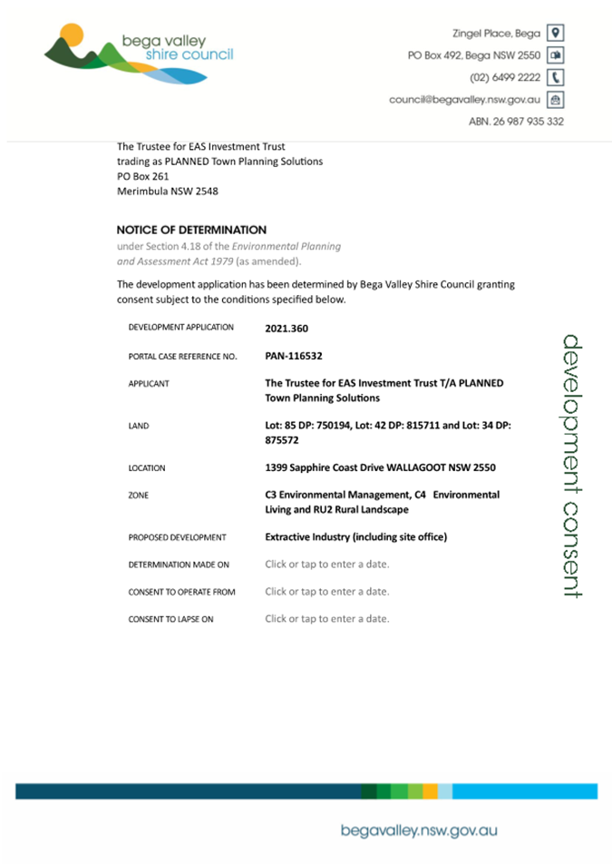
8.1. 2021.360 Extractive Industry (gravel quarry), 1399 Sapphire Coast Drive, Wallagoot
Chief Executive Officer
|
Applicant |
The Trustee for EAS Investment Trust (trading as PLANNED Town Planning Solutions) |
|
Owner |
Sapphire Pastoral Land Holding Pty Ltd |
|
Site |
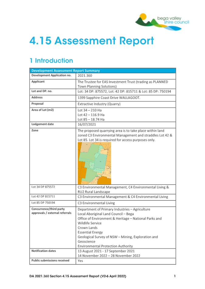
Lot: 34 DP: 875572, Lot: 42 DP: 815711 & Lot: 85 DP: 750194 – located at 1399 Sapphire Coast Drive WALLAGOOT |
|
Zones |
C3 Environmental Management, C4 Environmental Living and RU2 Rural Landscape |
|
Site area |
Approximately 340Ha |
|
Proposed development |
Extractive Industry (quarry) |
Precis
Development application 2021.360 is being reported to Council in accordance with Procedure 3.01.01 - Reporting of Development Applications to Council, as more than 10 unique submissions by way of objection were received during two notification periods for the application.
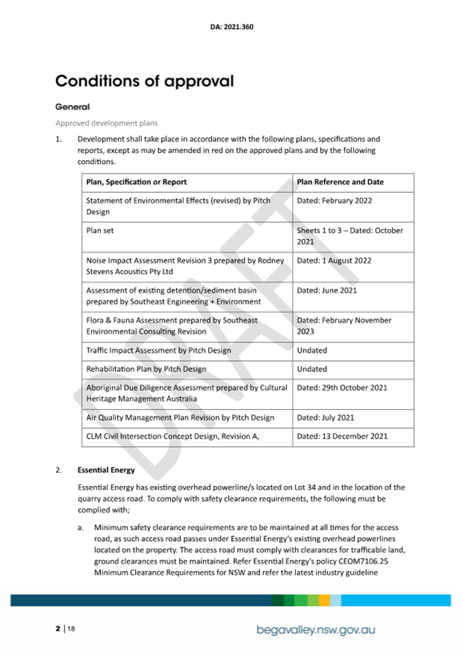
It is recommended that the development application be approved subject to the draft conditions of consent, as detailed in Attachment 1 to this report.
1. That Development Application 2021.360 for an Extractive Industry (quarry) be approved subject to the conditions outlined in the draft consent provided as Attachment 1.
2. That those parties who made a submission be advised of Council’s decision.
Executive Summary
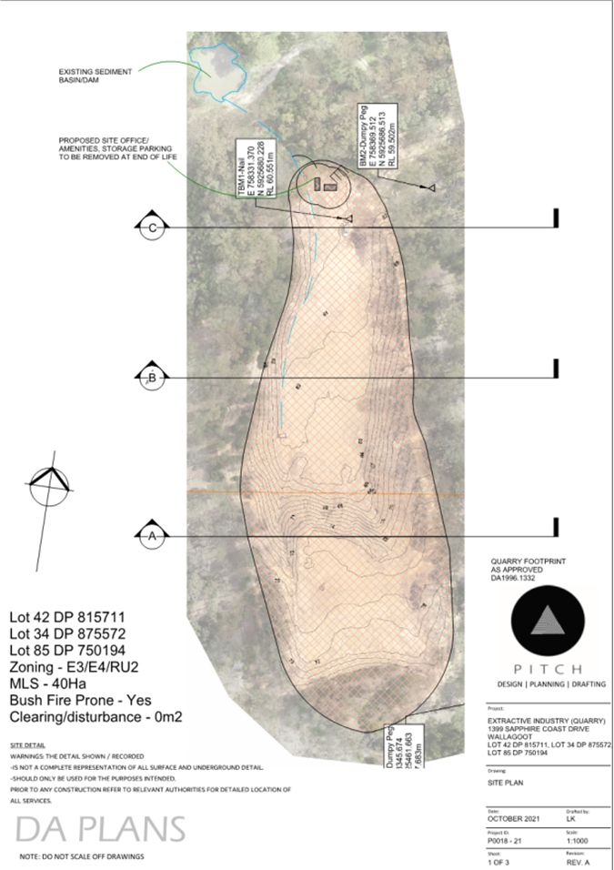
Development Application 2021.360 seeks consent for the operation of an Extractive Industry (rhyolite quarry) and associated works on Lot 42 DP 815711, Lot 34 DP 875572 and Lot 85 DP 750194, located at 1399 Sapphire Coast Drive, Wallagoot.
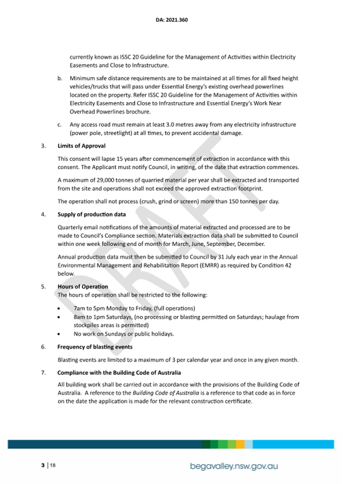
The proposal is to extract a maximum of 29,000m³ of material per annum, and to process a maximum of 29,000 tonnes per annum, for a period of 15 years with a 5-year option to account for industry supply and demand peaks and troughs.
The proposal does not trigger designated development provisions by operating within the past quarry operations footprint and by keeping extraction and processing amounts within specified limits.
The proposal is summarised as follows;
• operations not to exceed previously approved quarry footprint of 1.97Ha.
• excavation to a greater depth within the quarry footprint.
• annual limit of extraction of a maximum of 29,000m³.
• material to be won via ripping and blasting.
• process up to 29,000 tonnes via screening and crushing onsite per annum.
• life span of 15 years with an option to add a further 5 years.
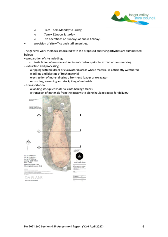
• operational hours of: 7am – 5pm Monday to Friday,
7am – 12 noon Saturday.
No operations on Sundays or public holidays.
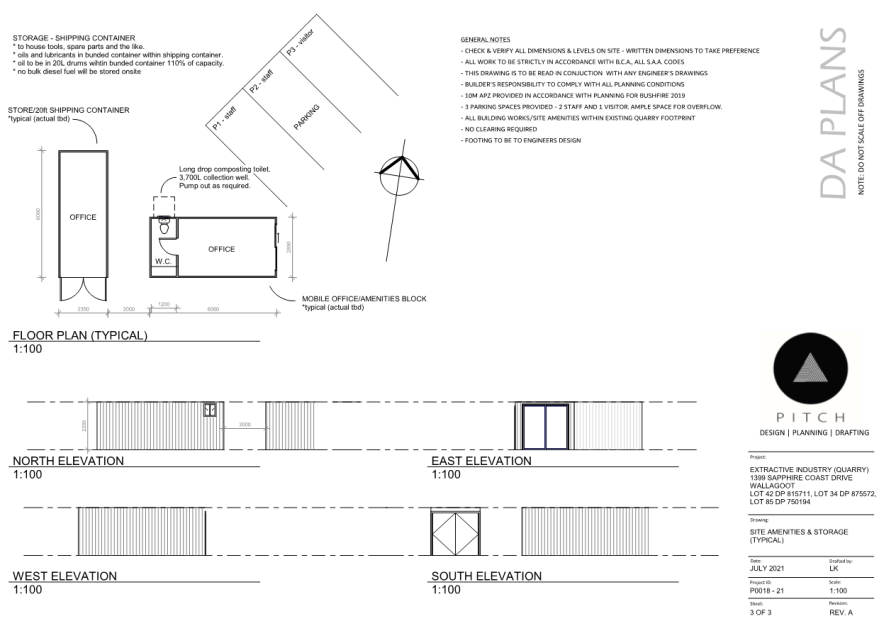
• provision of site office and staff amenities.
The proposal has been assessed in accordance with the relevant provisions of the Environmental Planning and Assessment Act 1979, with a detailed Section 4.15 Assessment included as Attachment 2 of this report.
The development application is being reported to Council in accordance with Procedure 3.01.01 Reporting of Development Applications, as more than 10 unique submissions by way of objection to the development were received. This report details the key issues raised in submissions and includes commentary from internal staff and external state agencies and service providers.
Background
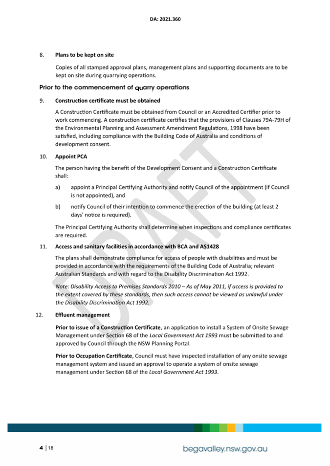
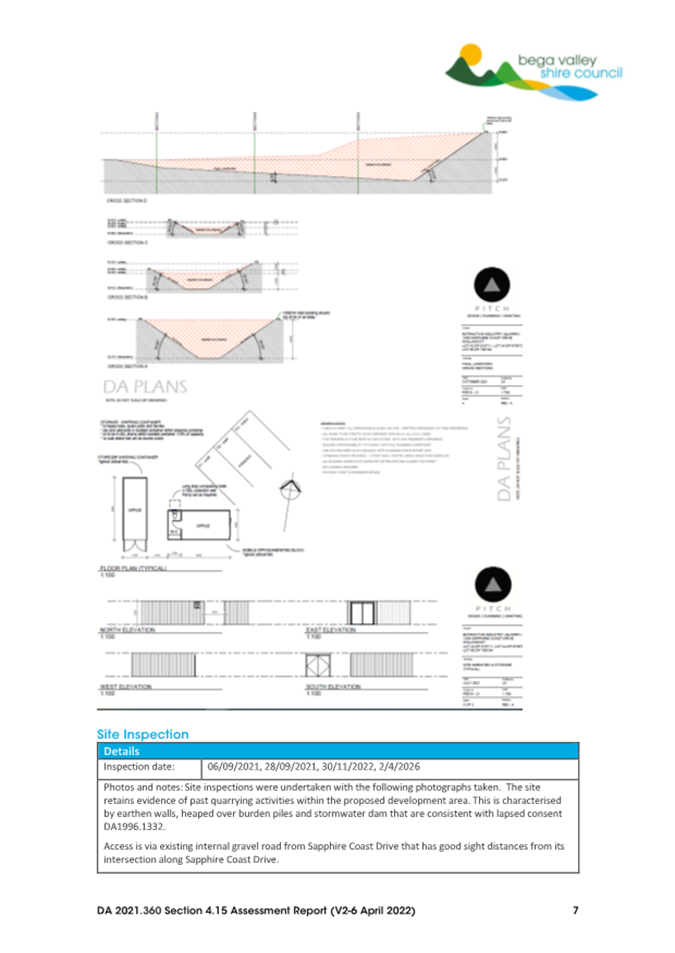
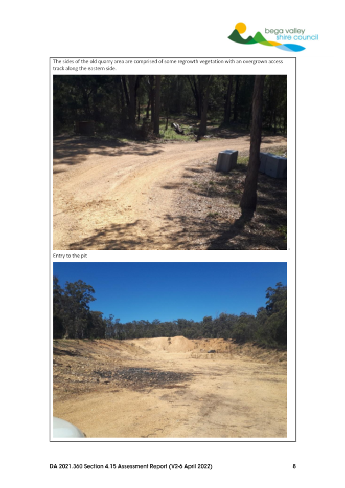
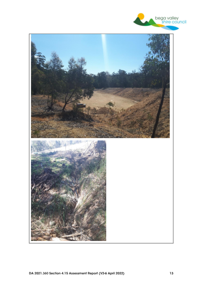
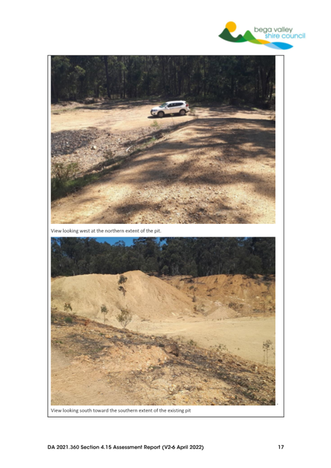
The proposed development site is located on the property known locally as ‘Bournda Downs’. The site has previously had approval under DA 1996.1332 for a Quarry that was approved by Bega Valley Shire Council on 2 September 1997. That approval was for a maximum extraction of 30,000m³ of gravel materials per annum, with no crushing or screening works to be carried out. It was estimated the life of the quarry was approximately 10 years. That development application was not considered designated development under the EP&A Act 1979 and did not require an Environmental Protection Licence under the provisions of the Protection of the Environment Operations Act 1997.
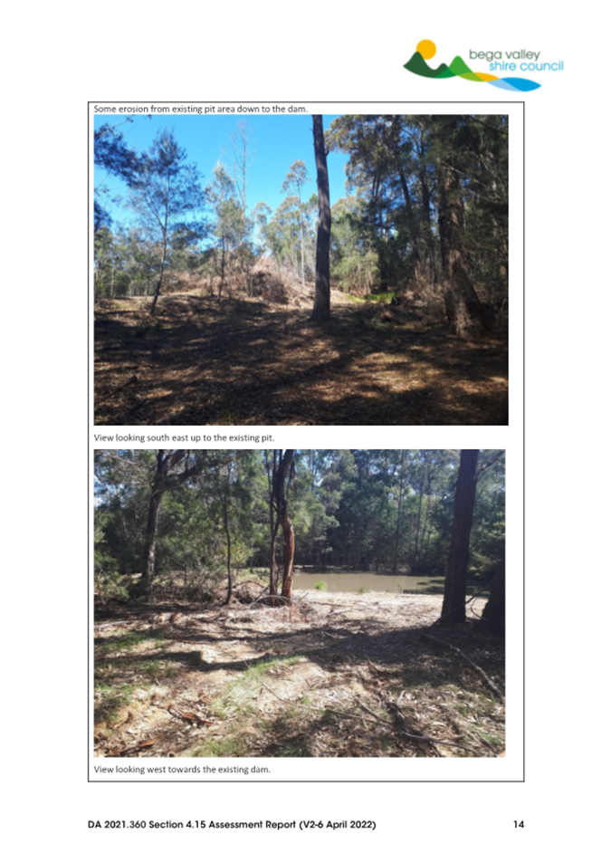
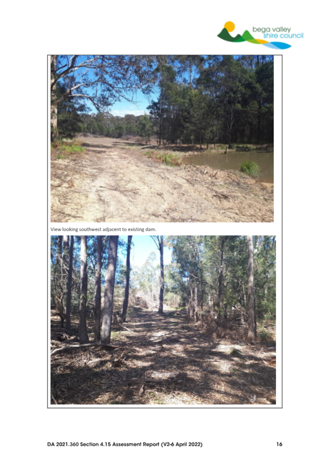
The original quarry site was approved with an area of 1.97Ha, with the quarry operations undertaking works in accordance with that approval including the clearing of vegetation, implementation of a stormwater management system and construction of a haulage road to connect the quarry to Sapphire Coast Drive. The construction of the stormwater management system and haulage road where both constructed and remain in situ.
The application details that during the time the quarry operated, the material extracted was used as road base in the local area, both on private and public roads. A review of Council records did not identify any registered complaints regarding the operation of the quarry.
Previous owners of the property had investigated reinstating quarry operations and even submitted a Development Application in 2012. However, this application was withdrawn, and the quarry was not reinstated.
A Development Advisory Panel meeting was held with representatives from Bega Valley Shire Council and the previous owner of the land on 22 April 2021 to discuss the proposed extractive industry and proposed lodgement of this Development Application.
This development application was subsequently lodged on the 16 July 2021. Additional information was submitted by the applicant on 31 August 2022 and 8 December 2022 to address concerns raised in submissions and additional information requirements identified by assessing staff and external agencies. The application has been through two public advertising periods, and those submissions have been reviewed as part of this assessment. Written responses by the applicant to the concerns raised have also provided throughout the assessment process.
The property has changed hands since the lodgement of the development application, and the new owners have requested determination of the application as presented.
The Site
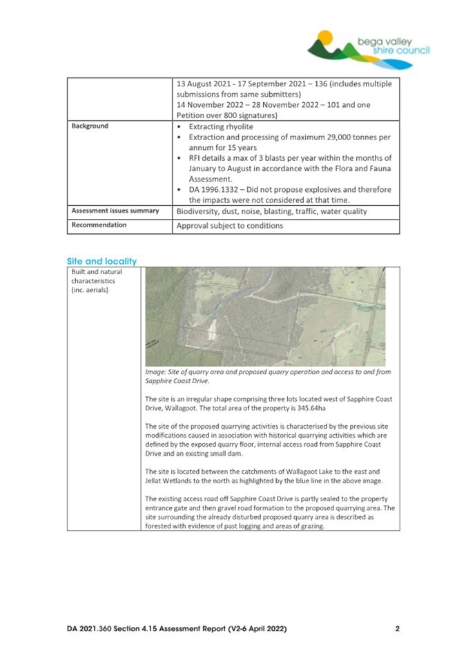
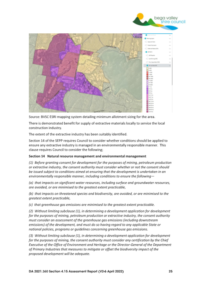
The site is located approximately 17 kilometres north of Merimbula and approximately 6km south of Kalaru via Sapphire Coast Drive. The total site area is 340 hectares and comprises three allotments that is locally known as the ‘Bournda Downs’ property (See Figure 1 below for location).
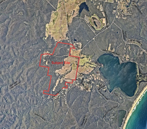
Figure 1 – Subject Site location
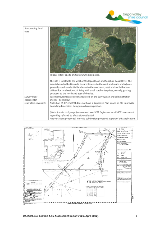
The property adjoins Bournda Nature Reserve to the west and south and freehold land to the north, east and south-east. Wallagoot Lake is located approximately 1000m from the eastern boundary of the property and 2600m to the proposed quarry site.
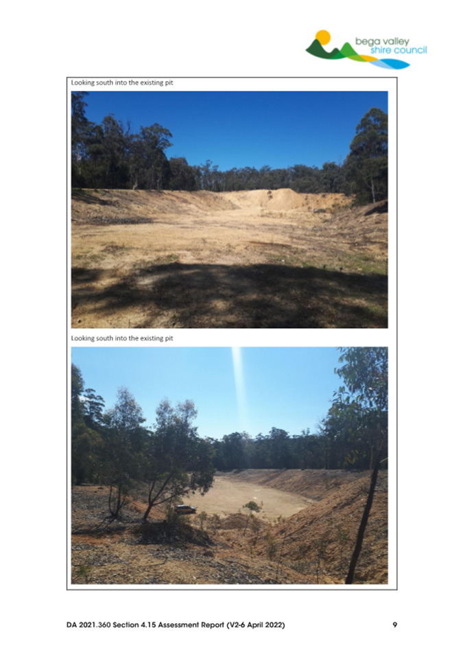
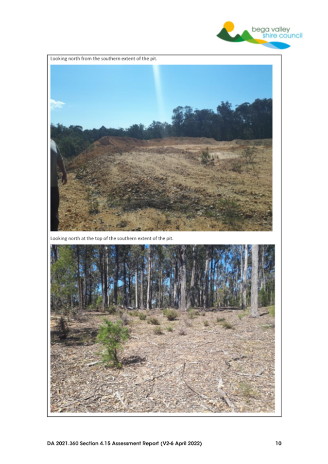
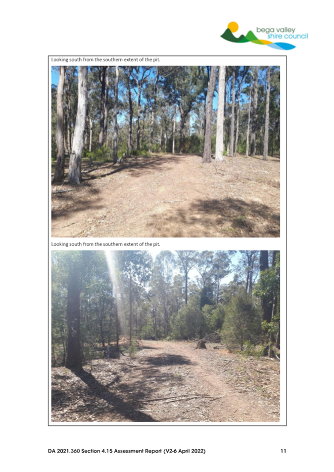
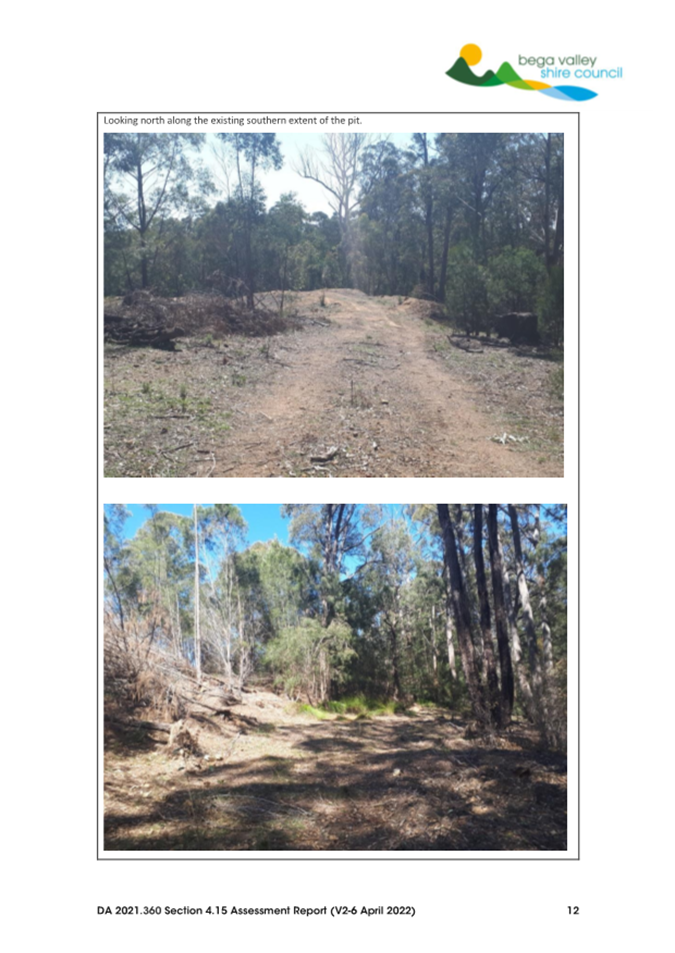
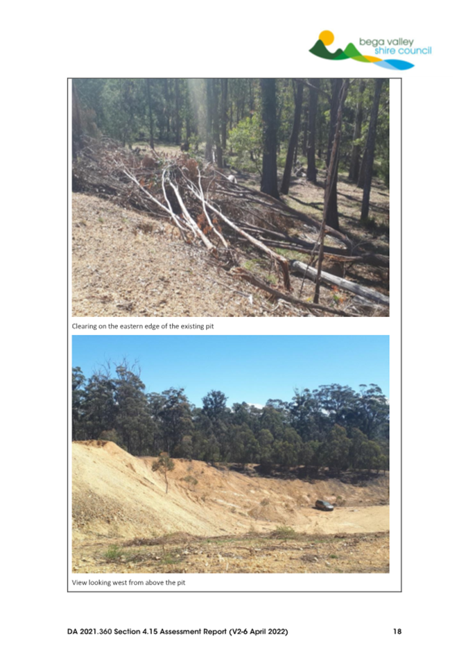
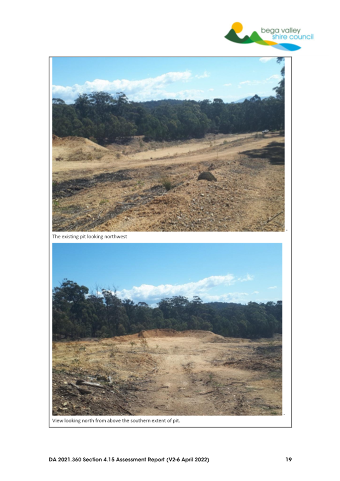
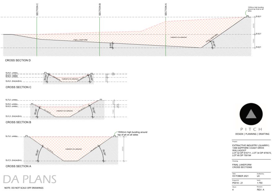
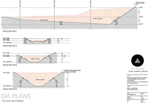
The proposed development is similar to the footprint of the previous approval applying to the site and located as indicated in Figure 2 below. The quarry site is in the south-west corner the property, located near the top of a small ridge and surrounded by forested and partially cleared lands.
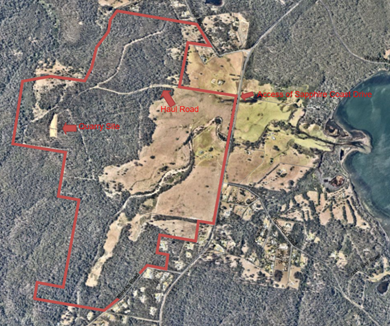
Figure 2 – Quarry location within site
The site of the proposed quarry is characterised by past extractive activities and is bound on three sides by substantial excavation below the ridge and includes areas of overburden.
The surrounding land uses are either heavily forested lands to the west and south-west or used for rural/rural-residential lifestyle allotments located to the south-east, east and north-east. The nearest residence not associated with the proposed extraction and processing areas is approximately 1.2km away.
Description of the Proposal
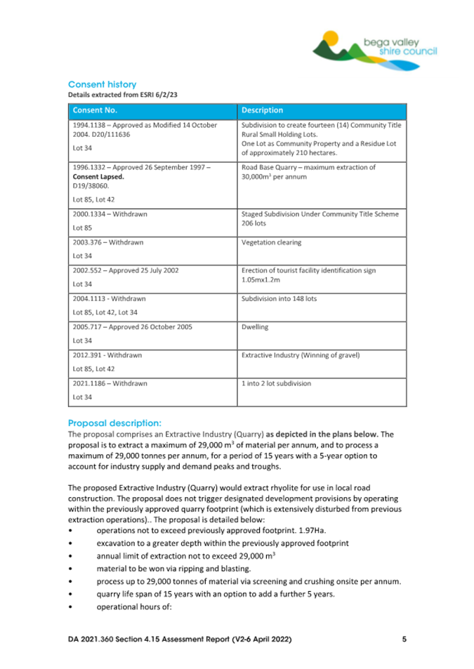
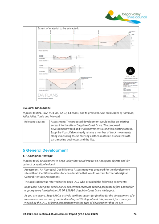
The proposal comprises an Extractive Industry (quarry) as depicted in the plans below. The proposal is to extract a maximum of 29,000m³ of material per annum, and to process a maximum of 29,000 tonnes per annum, for a period of 15 years with a 5-year option to account for industry supply and demand peaks and troughs.
The proposed Extractive Industry (quarry) would extract rhyolite for use in local road construction. The proposal does not trigger designated development provisions by operating within the existing quarry footprint and keeping extraction within required limits. The proposal is both summarised and detailed below.
• operations not to exceed previously approved footprint. 1.97Ha.
• excavation to a greater depth within the approved footprint.
• annual limit of extraction of a maximum of 29,000m³.
• material to be won via ripping and blasting.
• process up to 29,000 tonnes via screening and crushing onsite per annum.
• life span of 15 years with an option to add a further 5 years.
• operational hours of 7am – 5pm Monday to Friday, 7am – 12 noon Saturday. No operations on Sundays or public holidays.
• provision of site office and staff amenities.
The general work methods associated with the proposed quarrying activities are summarised below:
• preparation;
o Installation of erosion and sediment controls prior to extraction commencing.
• extraction and processing;
o ripping with bulldozer or excavator in areas where material is sufficiently weathered.
o drilling and blasting (maximum of 3 blasts per year) of fresh material.
o extraction of material using a front-end loader or excavator.
o crushing, screening and stockpiling of materials.
• transportation;
o loading stockpiled materials into haulage trucks.
o transport of materials from the quarry site along haulage routes for delivery.
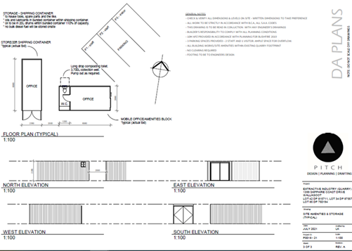
Development Plans are provided as Attachment 4 to this report.
The Statement of Environmental Effects and accompanying supporting reports and documentation are available on Council’s DA Enquiry page, reference 360/2021, link here: Authority e-Services
Planning Assessment
The development application has been assessed in accordance with the relevant matters for consideration under Section 4.15 of the Environmental Planning and Assessment Act 1979 (refer to Attachment 2). The assessment responds to relevant Environmental Planning Instruments that apply to the proposed development and site.
Bega Valley Local Environmental Plan 2013
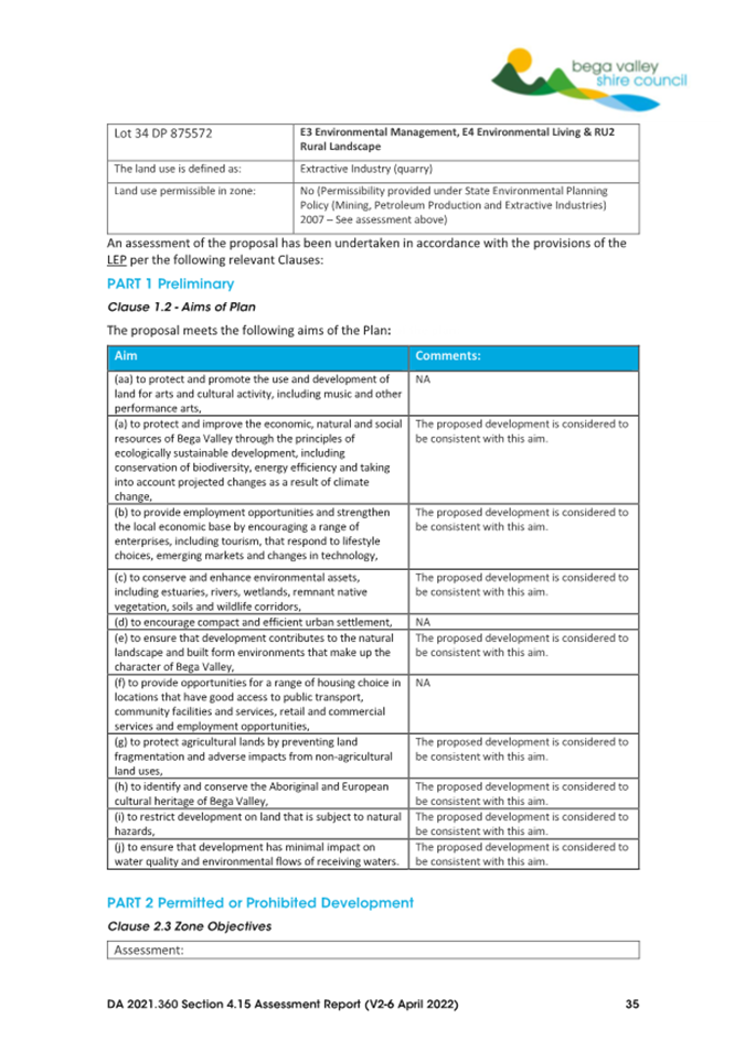
The proposed development is defined as an Extractive Industry. Extractive industries are defined under Bega Valley Local Environmental Plan (BVLEP) 2013 and means;
the winning or removal of extractive materials (otherwise than from a mine) by methods such as excavating, dredging, tunnelling or quarrying, including the storing, stockpiling or processing of extractive materials by methods such as recycling, washing, crushing, sawing or separating, but does not include turf farming.
Note. Extractive industries are not a type of industry.
Extractive material means;
sand, soil, gravel, rock or similar substances that are not minerals within the meaning of the Mining Act 1992.
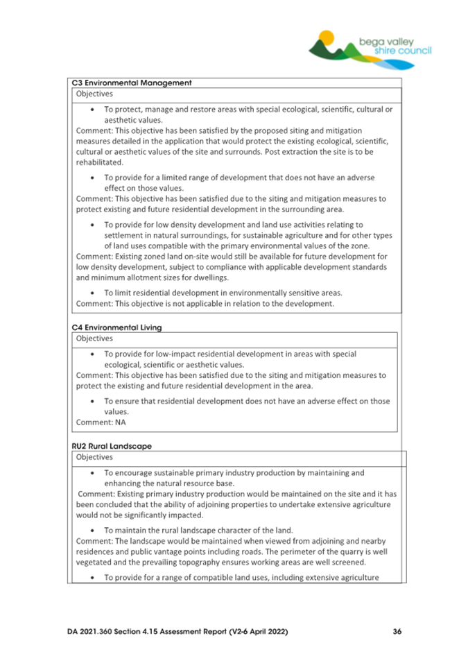
The development has been assessed in accordance with the relevant provisions of Bega Valley Local Environmental Plan (BVLEP) 2013. Under BVLEP 2013, Extractive Industries is a prohibited use in the C3 – Environmental Management, C4 – Environmental Living and RU2 -Rural Landscape zones.
The permissibility of Extractive Industries can however be considered under State Environmental Planning Policy (Mining, Petroleum Production and Extractive Industries) 2007 as is the case for this application, where an extractive industry would otherwise be prohibited and is detailed below.
State Environmental Planning Policy (SEPP) (Mining, Petroleum Production and Extractive Industries) 2007
SEPP Mining, Petroleum Production and Extractive Industries applied at the time of lodgement of this application. Clause 7 - Development of the SEPP provides that the proposal is permissible with consent, and details the following;
(3) Extractive industry Development for any of the following purposes may be carried out with development consent—
(a) extractive industry on land on which development for the purposes of agriculture or industry may be carried out (with or without development consent),
(b) extractive industry in any part of a waterway, an estuary in the coastal zone or coastal waters of the State that is not in an environmental conservation zone.
Whilst under BVLEP 2013, Extractive Industries are prohibited in the C3, C4 and RU2 zones, for the purpose of Clause 7(3) of the SEPP, an extractive industry may be carried out with development consent on land on which development for the purposes of agriculture or industry may be carried out (with or without development consent). Zones C3, C4 and RU2 under BVLEP 2013 all permit Extensive Agriculture without consent.
Extensive Agriculture is defined under BVLEP 2013 and means any of the following;
(a) the production of crops or fodder (including irrigated pasture and fodder crops) for commercial purposes,
(b) the grazing of livestock (other than pigs and poultry) for commercial purposes on living grasses and other plants on the land as their primary source of dietary requirements, and any supplementary or emergency feeding, or temporary agistment or housing for weaning, dipping, tagging or similar husbandry purposes, of the livestock,
(c) bee keeping,
(d) a dairy (pasture-based) where the animals generally feed by grazing on living grasses and other plants on the land as their primary source of dietary requirements, and any supplementary or emergency feeding, or temporary agistment or housing for weaning, dipping, tagging or similar husbandry purposes, of the animals.
Note— Extensive agriculture is a type of agriculture.
Therefore, under the provisions of the SEPP, Council can consider the development application for an extractive Industry on the site.
The SEPP also requires Council to consider a number of matters when considering an application for extractive industries including the compatibility of an extractive industry with other land uses, whether or not the consent should be issued subject to conditions aimed at ensuring that the development is undertaken in an environmentally responsible manner, the efficiency or otherwise of the development in terms of resource recovery and the transportation of materials.
The detailed Section 4.15 assessment is included in Attachment 2 and addresses the SEPP matters of consideration. The assessment details that the proposed development is suitably sited and designed to mitigate potential impacts on other land uses located in the surrounding area and identifies appropriate mitigation measures which would include the need for conditions of consent to ensure ongoing compliance of its operation to mitigate potential impacts.
The application was publicly notified twice for periods of 14 days. A total of 237 submissions were received. Council also received a tabled petition of over 800 signatures that objected to the proposal over both submission periods. The issues raised are detailed further in this assessment report.
Suitability of the development
It is considered that the development is suitable for the site taking into consideration all information and reports submitted with the application. The use is permissible with consent and all relevant impacts have been considered in the assessment process. Suitable mitigation measures and conditions of consent can be included to protect and maintain the existing built and natural environment. Therefore, it is considered that the development is suitable for the site.
The location of the proposed quarry would not be visually prominent within the topography given the extensive vegetation around the proposed quarry working area and the natural topography of the land, which mitigates any visual impact to adjoining properties that contain residences or from public vantage points like Sapphire Coast Drive and other nearby public roads.
The quarry operations would include blasting, screening, crushing, loading and transportation activities that would have the potential to generate airborne dust that could affect the air quality of the surrounding environment. The Air Quality Management Plan submitted with the application includes a range of mitigation measures designed to minimise those potential impacts. The Plan details that due to the nature and composition of the material proposed to be extracted, the significant natural barrier provided by the intervening vegetation buffer, the distance to the nearest receivers marked R1 in Figure 3 below, and topography of the site, there is unlikely to be any significant dust issues.
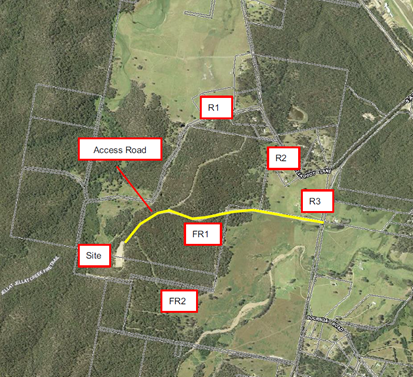
Figure 3: Location of nearest receivers noted R1, R2 and R3 of adjoining properties to operational aspects of the quarry.
The applicant provided a Noise Impact Assessment prepared by Rodney Stevens Acoustics (RSA) Pty Ltd. In order to characterise the existing acoustical environment of the area unattended noise monitoring was conducted between the dates of Tuesday 3 May and Monday 9 May 2022. The Report detailed that the data obtained from the noise logger was processed in accordance with the procedures contained in the NSW Environmental Protection Authority’s (EPA) Noise Policy for Industry (NPfI, 2017) to establish representative noise levels that can be expected in the residential vicinity of the site, as depicted in Figure 3 above.
The Noise Assessment Report also included blasting criteria and referenced the EPA’s ANZECC Guideline for Human Comfort which RSA Pty Ltd deemed as acceptable when assessing for human comfort in relation to blasting and also the use of machinery including trucks that will be used in the quarry operations. The noise assessment has adequately assessed the likely noise sources from blasting, crushing and transportation of materials and identified that recommended noise criteria to mitigate impacts can be met. The assessment also includes a range of mitigation measures to ensure compliance with the relevant standards and includes considerations for implementation over the life of operations at the site.
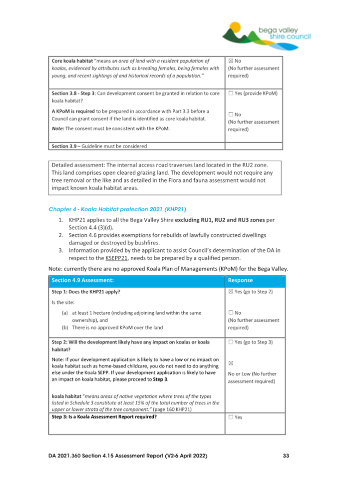
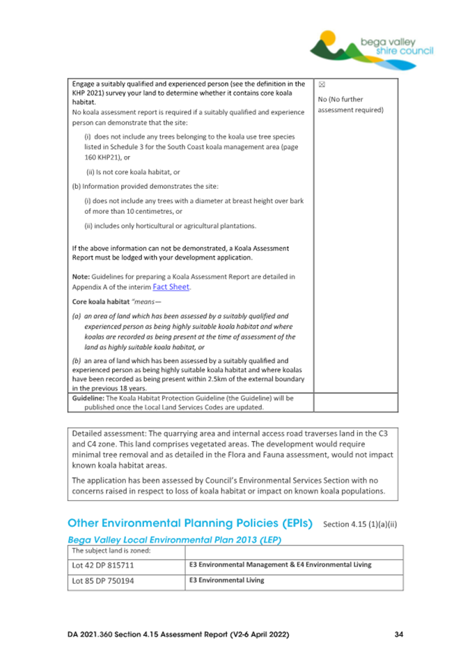
The development application has provided sufficient supporting information to consider and address the potential impacts on flora and fauna, in respect to both direct and indirect impacts including potential loss of wildlife corridors. The assessment of the application has raised no concerns that the proposal would have a significant effect on threatened species, threatened populations, ecological communities, or their habitats, provided compliance with the recommended mitigation measures detailed in the amended Flora and Fauna dated November 2023.
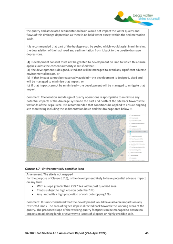
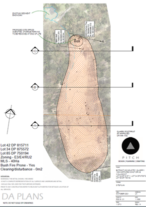
This is namely due to the fact that the proposal will utilise existing cleared areas and existing infrastructure, including sedimentation basin and haulage road. The extent of the vegetation clearing within the existing quarry footprint is detailed in Figure 4 below, illustrating the extent of remaining vegetation.
 Figure 4 – Quarry Footprint detailing vegetation
to be removed
Figure 4 – Quarry Footprint detailing vegetation
to be removed
There would be a small area of vegetation disturbed in the southerly extension of the quarry of 2375m² of native regrowth vegetation but would not have an impact on resident or migratory fauna species.
Options
1. Approve the development application subject to the draft conditions of consent provided in Attachment 1. This is the recommended option.
2. Defer consideration of the matter and request a separate report identifying any relevant Section 4.15 matters for consideration and draft reasons for refusal.
3. Defer consideration of the matter and seek additional information from the Applicant (to be specified by Councillors).
Community and Stakeholder Engagement
The development application was publicly exhibited in accordance with Council’s Community Engagement Strategy on two occasions; once at lodgement of the development application and again upon receipt of requested additional information. The exhibition periods were on the following dates;
13 August 2021 - 17 September 2021 – 136 submissions (includes multiple submissions from same submitters).
14 November 2022 – 28 November 2022 – 101 submissions and one previously tabled petition to Council of over 800 signatures.
The issues raised in these submissions have been detailed and addressed in the Section 4.15 Assessment Report, which is included as Attachment 2.
A full copy of submissions has been uploaded to the Councillor portal for information.
The key issues raised in submissions are outlined below, followed by staff comment.
Permissibility
Numerous submissions raised concerns regarding the permissibility of the proposed development, especially that Extractive Industries were prohibited by Bega Valley Local Environmental Plan 2013 within the zones the subject site is located within. Submissions also detailed that this would set a dangerous precedent which could open the door for many more inappropriate applications in C3 and C4 zones and suggesting that Council may find itself facing litigation. Submissions questioned what processes would be in place to ensure the proposed development would be operated appropriately and mechanisms to ensure the operations comply with relevant standards and operating parameters.
Staff assessment:
As detailed earlier in this report, the development application has been assessed in accordance with the matters for consideration under Section 4.15 of the Environmental Planning and Assessment Act 1979 to ensure the permissibility of the development.
The proposed development is permissible with consent in accordance with Clause 7 - Development permissible with consent under State Environmental Planning Policy (Mining, Petroleum Production and Extractive Industries) 2007. The State Environmental Planning Policy prevails over the provisions set by Bega Valley LEP 2013 where inconsistencies may exist.
Consideration of precedent in the determination of this application is not considered valid as Council is assessing the application on merit and in accordance with the legislative framework that applies under State Environmental Planning Policy (Mining, Petroleum Production and Extractive Industries) 2007.
Suitable conditions of consent are recommended to ensure the development operates in accordance with the mitigation measures and legislative framework, including requiring extraction and production data supply and monitoring. Council is the regulatory authority in relation to this development and will be responsible for monitoring compliance with any conditions of consent.
Amenity
Numerous submissions raised concerns regarding the potential impacts on the existing and future amenity of adjoining and nearby residential development, as well the potential impacts on the environmental uses of adjoining properties and the tourist operations that are derived from those areas.
Staff assessment:
The application was reviewed in accordance with the applicable objectives of the three zones that the site includes and was identified that it would not be inconsistent with any of the objectives due to the proposed operational limitations and the various mitigation measures proposed.
Comments were received from the National Parks and Wildlife Service, and the application was assessed in respect to the relevant guideline, “Developments adjacent to National Parks and Wildlife Service lands (NPWS 2020)”. The assessment detailed no identified impacts on the adjoining Bournda Nature Reserve to the west and south of the site nor the wider Bournda National Park, including those lands in and around Wallagoot Lake.
The application seeks approval for operations over 15 years due to the varying nature in resource demand. The mitigation measures detail how the amenity of the surrounding area can be maintained in respect to residences located in the Wallgoot/Bournda area but also acknowledges other enterprises including ongoing agricultural activities, tourism and other enterprises in the area.
The location of the proposed quarry would not be visually prominent within the landscape given the extensive vegetation around the proposed quarry working area and the natural topography of the land, which mitigates any visual impact to adjoining properties that contain residences and from public vantage points like Sapphire Coast Drive and other nearby public roads.
The only visual impact would be from additional truck movements along the existing internal road to and from Sapphire Coast Drive. Consideration of dust generation being visually identifiable within the landscape has been considered and dust control can be managed by implementation of appropriate mitigation measures. The applicant provided an Air Quality Management Plan to assist in identifying risks associated with air quality at the proposed extractive industry site for safety, health and amenity.
Recommended conditions of consent detail compliance with the identified mitigation measures as well as reporting responsibilities to ensure ongoing reporting and review throughout the life of the development. It is considered that the amenity of the area can be maintained for the 15 years of the proposed operation of the extractive industries and its associated operations including haulage. The applicant has requested an option for a five year extension of the quarry life. This would be subject to separate subsequent approvals and is not supported by assessing officers at this time.
Flora/Fauna/Biodiversity
Numerous submissions raised concerns regarding the potential impacts on flora and fauna that inhabit the site including behaviour, movement, feeding and breeding as well potential impacts on adjoining lands including the Bournda Nature Reserve. Submitters raised concerns there would be adverse impacts including loss of biodiversity, impact to wildlife corridors and direct and indirect impacts associated with dust, noise and loss of vegetation.
Staff assessment:
The potential for flora and fauna and biodiversity impacts have been suitably considered and addressed in the Section 4.15 assessment report. It was identified that following application of the Section 5A of the EP&A Act and in accordance with relevant assessment guidelines, it is concluded that the proposal is unlikely to have a significant effect on threatened species, threatened populations, ecological communities, or their habitats if mitigation measures are taken.
The quarry footprint has been largely cleared and a road to the quarry exists so direct impacts from quarry works within the existing footprint will be minimal in terms of vegetation loss. The southern expansion of the quarry site will require the removal of 2375m² of native vegetation. The site is not identified on the NSW Biodiversity Values Map and the proposal does not trigger the Biodiversity Offset Scheme.
Two Threatened Ecological Communities (TECs) are mapped within the wider allotment on which the quarry site is located (being Freshwater wetlands on coastal floodplains of the NSW North Coast, Sydney Basin and South East Corner bioregions and Lowland Grassy Woodland in the South East Corner Bioregion). However, the subject quarry site and operational footprint are geographically removed from the areas mapped.
The Commonwealth Department of Climate Change, Energy, Environment and Water determined in November 2025 that the proposed re-starting of quarrying activities does not trigger any EPBC Act requirements and is not considered a “controlled action” under that legislation.
The proposal would be limited to three blasts per year and the flora and fauna assessment identified a requirement to avoid blasting during the months of September to December when a larger number of mammals and birds are breeding and/or have young. This restriction of operations is recommended as a condition of consent. The report’s mitigation measures also recommend the use of a siren to warn mobile animals that the blasting is about to occur. All mitigation measures recommended shall be implemented as part of compliance with Condition 1 of the recommended conditions of consent.
In addition, suitable conditions of consent are proposed to ensure that; vehicles entering the site suitably manage the potential for weed dispersal into the area, quarry operations are to be controlled through operational management plans and post operation site rehabilitation measures enable revegetation of the area to remediate impacted areas.
It is considered that potential impacts on flora and fauna have been suitably addressed by the applicant and direct and indirect impacts can be mitigated and managed throughout the proposed 15 years of the operation.
Traffic
Numerous submissions raised concerns regarding the potential impacts of increased traffic onto Sapphire Coast Drive, potential safety issues of heavy vehicles using that road with trucks entering at a 100km/hour stretch of road and questioned what safeguards will be in place to stop truck drivers using Wallagoot Lane as a shortcut to get back to the quarry, or to their destination.
Staff assessment:
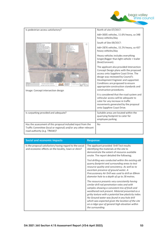
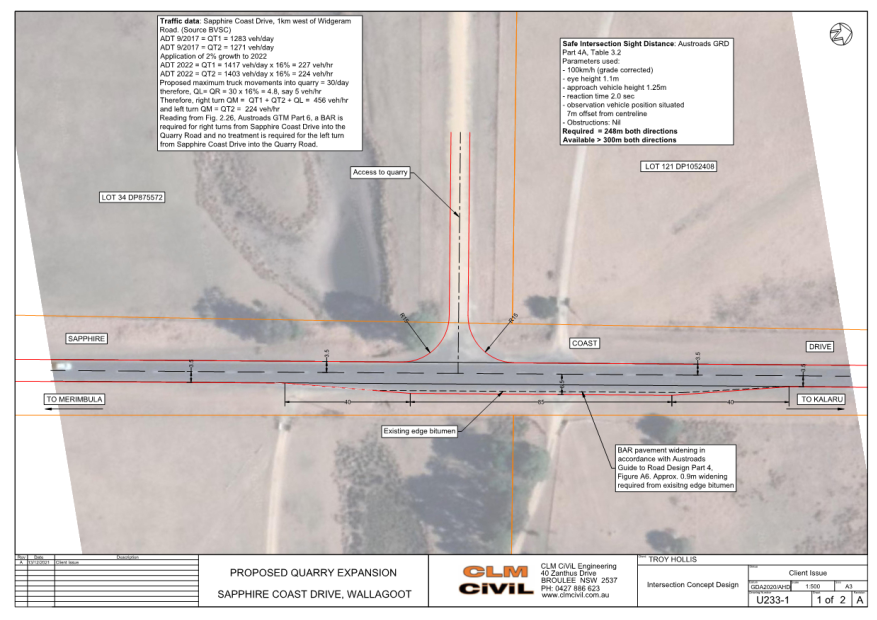
The traffic generation and suitability of the proposed access off Sapphire Coast Drive has been assessed by Council’s assessing officers. The existing intersection has good sight distance, and it is recommended that it be upgraded to comply with Council’s current standards.
The generation of traffic is considered reasonable given past traffic counts along Sapphire Coast Drive and the expected development growth within the wider area, both in terms of residential and other permissible uses.
The application proposes a speed limit of 30km/h on the internal haulage road to minimise noise and dust, which is supported and included as a recommended condition of consent. In addition, sealing of the internal road to a point 620 metres from the intersection with Sapphire Coast Drive would be required as a condition of consent, as a further dust mitigation measure.
It is further recommended that a condition be placed on any consent restricting trucks to use Sapphire Coast Drive, being a two lane bitumen sealed road, and prohibiting associated haulage trucks using Wallagoot Lane being a gravel road.
It is considered that potential impacts of traffic generation for the 15 years of the proposed operation of the extractive industry are appropriate and the development can be reasonably conditioned to mitigate impacts.
Noise/Blasting
Numerous submissions raised concerns regarding the potential impacts of quarry operational noise on residential land uses and on fauna in the area, including livestock on larger acreages. These impacts include those associated from blasting, excavations and processing of quarry materials and haulage of the materials from the site. The concerns raised detail that the topography of the site means residents to the south and east would be impacted. Concerns were also raised regarding the potential noise impact of explosives on birdlife and other species.
Staff assessment:
The noise assessment has suitably considered the impacts for adjoining and nearby residents with the potentially most impacted residences (referred to as Receiver 1 and 3 in the Noise Impact Assessment Report and detailed in Figure 3 above) being specifically assessed, having regard to the quarry’s operation including blasting, quarry operations and transport of materials.
The design of the quarry is such that working areas will be located below existing ground levels and would face away from residences. The design helps with minimising noise impacts on residences to the south, south-east and east of the proposed working area. Other topographic features to the north also assist in managing noise to residences to the north-east and north of the site.
The noise impacts have been assessed by relevant staff within Council and the applicant’s assessment report is suitable in identifying the potential impacts and required mitigation measures. Conditions are recommended to ensure compliance with the operation of the quarry and for ongoing monitoring for the life of its operations. This includes maintenance of plant and equipment to ensure all noise producing equipment is suitably maintained and not contributing to higher noise levels than modelled, reporting obligations including those of proposed blasts to ensure residents are suitably notified and any complaints are documented and suitably addressed.
Consideration of potential noise impacts to flora and fauna has been undertaken with no identified adverse issues raised. Conditions are proposed in regard to warning of blasts to mitigate impact during blasting events.
Air quality
Numerous submissions raised concerns regarding the potential impacts of dust on both adjoining residents at properties in the surrounding area, but also flora and fauna.
Staff assessment:
The Air Quality Management Plan provides consideration of the likely air pollution impacts from the operation of the quarry and provides numerous recommendations to mitigate them.
Council is supportive of the majority of the mitigation measures, which include the following;
• watering down of stockpiles, both processed and unprocessed
• the use of sprinklers on crushing and screening plant
• watering unsealed sections of haulage routes and the quarry floor/operation areas regularly to minimise dust generation.
• implementation of a Blast Protocol to minimise dust and flyrock generation.
• requiring loads to be covered at all times during transport and tail gates secured in the closed position.
• water cart to be available on the access road for dust suppression during transport of material, especially when large quantities are being transported in dry conditions.
• access route to be signposted to ensure a low speed to minimise dust generation.
• access route to be signposted to ensure a low speed to minimise dust generation.
• should dust deposition from the quarry or from transportation along the access road cause nuisance to residents, sampling in accordance with Australian Standards shall be carried out
However, it is recommended that the first 620m of the access road be upgraded to a sealed finish to further mitigate potential dust generation.
Consideration of silica dust or Respirable Crystalline Silica (RCS) has been undertaken. A significant amount of silica is present in most rocks, clays, sands, gravel and shale. Exposure to silica dust can lead to the development of lung cancer, silicosis (an irreversible scarring and stiffening of the lungs), kidney disease and chronic obstructive pulmonary disease. With any quarry, it is a requirement to comply with the current Work Health and Safety Regulations when it comes to dust generation. It is recommended that a dust monitoring station be installed at Receiver 3, as identified in the noise assessment impact report, to ensure that dust is being managed for the life of the development.
It is considered that all reasonable steps to identify and manage potential dust impacts have been identified. Additional mitigation measures have been recommended to further mitigate potential dust to the nearest affected residence. Specific conditions of consent are also recommended to ensure suitable air quality monitoring and mitigation measures are in place throughout the life of the quarry.
Water availability and impacts
Numerous submissions raised concerns regarding the potential impacts of quarry operation on the surrounding waterways, including potential impacts on existing bores in the surrounding area.
Staff assessment:
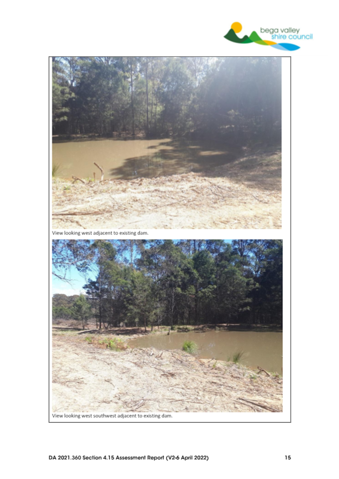
Any water will be captured by the existing quarry and the associated sedimentation dam. From inspections it is clear that no sediment from the quarry area or associated sediment dam traverses back towards Wallagoot Lake. No potential impacts on recreational fishing, prawning or the like for Wallagoot Lake were identified during the assessment of the application.
The assessment of the existing sedimentation basin utilised calculations for a worst-case scenario by assuming the quarry at full operational capacity and without the benefits of the additional proposed water quality management measures such as:
• Collection and retention of runoff within the quarry pit and potentially reduced overflow volumes
• Sediment and erosion controls other than the sediment basin
• Reuse of runoff within the quarry pit and potentially reduced overflow volumes
It is considered that the design and operation can suitably manage stormwater runoff for the quarry area to mitigate impacts on the swamp system downstream that then enters the Bega River.
The drill hole test results did not detail any ground water at depth and therefore it is not considered there would be any adverse impacts on any existing ground water supplies.
As detailed throughout the assessment, stormwater entering the quarry working areas will be suitably managed. There would be no water directed to the adjoining Bournda Nature Reserve.
Social benefit of the development
Submissions raised concerns regarding whether there was any social benefit of the development due to the perceived severe indirect/direct impacts of the quarry on the surrounding locality. Submissions questioned whether there should be significantly more than the economic benefit of one entity.
Further, submissions also detailed that such a development would potentially devalue residential properties in the area.
Staff assessment:
In considering this issue, the review of all impacts and proposed mitigation measures have been taken into consideration. The extractive industry is located well away from residential land uses located in the wider Wallagoot/Bournda area. Potential impacts have been suitably identified, assessed and mitigation measures proposed to ensure any impacts can be controlled within acceptable standards and capable of being monitored over the 15 year life span of the development.
The impact on property values is not a planning merit consideration. The relevant social and economic impacts of the proposal have been suitably considered in the assessment of the application.
Engagement planned
In the determination of this application, all persons who have lodged submissions and relevant State agencies will be notified of Council decision, in keeping with Council’s adopted Community Engagement Strategy 2025-29.
Financial and Resource Considerations
Assessing proposals is part of the regular business of Council and resourcing to undertake this function is included in Council’s adopted budget. Legal /Policy
Refusal of the development application could be subject to an appeal in the Land and Environment Court, which would have cost impacts to defend Council’s position.
Impacts on Strategic/Operational/Asset Management Plan/Risk
Strategic Alignment
Strategic Alignment
The proposed development application is not inconsistent with the future directions of the Bega Valley Shire Local Strategic Planning Statement 2040 and Council’s adopted Community Strategic Plan 2042, and draft South-East and Tablelands Regional Plan 2036.
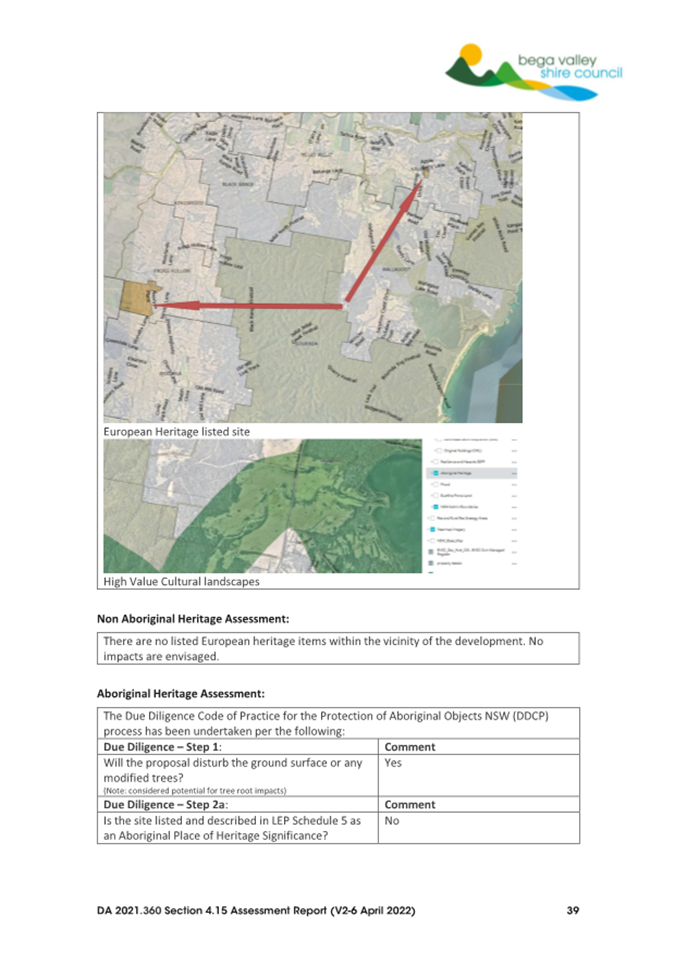
Environment and Climate Change
The impacts of the Extractive Industry have been suitably detailed in the Section 4.15 Assessment Report, which is provided as Attachment 2 to this report.
Economic
The extraction of material is used for road base that contributes towards development within the Bega Valley Shire.
The location of the quarry is sited and designed to ensure impacts can be managed and mitigated so as to not adversely impact on adjoining land uses and the recreational/tourist uses in the wider Bournda and Wallagoot areas.
Risk
The risks associated with the operation of the Extractive Industry have been addressed through recommended operational conditions of consent. Non-compliance with these conditions presents a risk to the public and would be subject to further compliance action.
Social / Cultural
The approval and operation of the quarry will provide additional road base material for use in the construction and maintenance of infrastructure within the Bega Valley Shire. The assessment of the application details that the extent of works are largely within existing disturbed areas and therefore impacts on archaeology and cultural heritage items/areas is unlikely.
Attachments
1⇩. Draft Conditions of Consent
2⇩. Section 4.15 Assessment Report
3⇩. Concept design for intersection with Sapphire Coast Drive
4⇩. Development Plans
|
Item 8.2 |
8.2. Affordable Housing Implemention Group review
This report provides the outcome of an internal review into the need for the continuation of the Affordable Housing Implementation Group and recommends the group is reshaped into an affordable housing stakeholder forum.
Director Community Environment and Planning
That Council:
1. Acknowledges the work of the Affordable Housing Implementation Group since it was established in September 2022
2. Reshapes the group into an affordable housing stakeholder forum that convenes twice per year, with membership as described in this report, and convened by the Director of Community, Environment and Planning.
Executive Summary
In line with the Council resolution from February 2026, staff have undertaken a review of the Affordable Housing Implementation Group.
The review found that the Council-led actions are predominantly underway or complete, noting many are ongoing; actions that need input from others haven’t progressed; and Council staff have good working relationships with the key service providers and government agencies.
Based on this, it is recommended that the group be reshaped into an affordable housing stakeholder forum that meets twice per year. Membership would comprise local housing providers, service providers, relevant state government representatives and Council staff. The forum would enable stakeholders to discuss current affordable housing issues, ensure collaboration across the sector and develop joint advocacy.
Meetings would align with the 6-monthly reporting cycle to the elected Council.
Background
The Bega Valley Affordable Housing Strategy was adopted in May 2022. The strategy provides a framework to respond to housing need in the Bega Valley Shire to 2040, and aims to:
• clearly articulate the role of various stakeholders in delivering affordable housing in shire and opportunities for collaboration among those stakeholders
• identify short, medium and long-term strategies for Council and other key stakeholders, to support housing development suitable for our growing population, ageing community and changes in household structure
• identify key performance indicators to monitor housing affordability and implementation of the strategy
• align with federal and NSW policy, including considering proposed changes to housing policy currently underway in NSW.
Strategy 1(c) included the convening of an:
Affordable Housing Implementation Group to implement and monitor progress of the strategy, including representation by Council elected representative and staff, community agencies and community representatives, and broadening representation to fill existing gaps, for example, from the Aboriginal community.
An Affordable Housing Implementation Group (AHIG) was subsequently established in September 2022 following a public call for nominations and written invitations to key stakeholders.
At the February 2026 Council meeting, Council resolved that staff provide a report reviewing the need for the continuation of the Affordable Housing Group. The minutes are available on the Council website here: Minutes of Council - Wednesday, 25 February 2026 (Item 8.1).
Current membership
Current membership of the Affordable Housing Implementation Group includes:
• Homes NSW
• Southern Cross Housing
• Mission Australia
• South East Women’s and Children’s Service (SEWACS)
• Department of Communities and Justice (DCJ)
• Social Justice Advocates (SJA)
• Community members: Roz Hansen, Leanne Atkinson, Cathy Griff
• Crs O’Neil and Haggar
• Director Community, Environment and Planning
The CEO also attends the majority of the meetings.
Katungal was previously a member, however following an internal restructure did not have capacity to participate.
Meetings
The AHIG meets quarterly, chaired by Director Community, Environment and Planning.
Council staff provide updates on key actions, and the implementation plan is tabled with updates against each strategy.
Southern Cross Housing and Homes NSW provide an update on their activities in the Bega Valley Shire, however Homes NSW no longer attends meetings following recent restructures, limited resourcing, and the nature of the group.
Currently, the majority of the meetings are spent responding to concerns and requests from the community members and SJA on what is being done to generate more housing, reduce homelessness and increase crisis housing, including requests for Council to focus on actions outside of the strategy. Members are not actively contributing to implementing the strategy, aside from Homes NSW and SCH who are actively undertaking social and affordable housing development in the Bega Valley Shire. Actions that rely on other partners have not progressed.
Affordable Housing Strategy implementation progress
It is important to note that the Affordable Housing Strategy includes
27 strategies, with 66 individual actions. Of these:
• 12 are complete
• 35 are ongoing
• 5 are in progress
• 10 are not yet started
• 3 are closed
• 1 is under review (as discussed in this report).
The ‘ongoing’ actions are, by nature, actions that will continue for many years if not indefinitely. They include advocacy on a range of different housing related issues, connecting private developers with housing providers, supporting the Local Aboriginal Land Councils to develop housing on their land, providing advice, and consulting with government and/or organisations.
Twice a year, progress reports are provided to the elected Council with clear updates on progress against each of the 66 actions, as well as a summary of the key progress and advocacy undertaken in the past 6 months. Reports are provided in February and August each year, covering the period 1 July to 31 December and 1 January to 30 June respectively. The most recent report is available here: Agenda of Council - Wednesday, 25 February 2026 (Item 8.1).
Significant actions predominantly underway or compete, include:
• Changes to the Bega Valley Local Environmental Plan (LEP) to increase housing diversity across the shire
• Affordable Housing Contributions policy adopted following a detailed feasibility assessment
• Affordable Housing Contributions scheme under development as part of Bega urban expansion rezoning
• Bega and Wolumla Structure Plans developed
• Bega urban expansion rezoning project well progressed
• Urban Renewal Project commenced, including investigations into land suitable for increased height and floor space ratio the Bega, Eden and Merimbula town centres, including a review of heights in Merimbula town centre
• Homes NSW redevelopment of the former Bega TAFE site well advanced, which will include around 24 social dwellings as well as key worker and market housing
• Homes NSW DA to replace 2 houses in Eden with a 10-unit seniors housing development approved (under Part 5)
• Investment of $900,000 from the sale of Narira Village in Cobargo with Southern Cross Housing for their development in Rawlinson Street Bega
• Southern Cross Housing development application for a site in Bega to provide 60+ social and affordable dwellings approved by Southern Regional Planning Panel.
• Ongoing DA assessment, including a caravan park at Kalaru increasing its permanent sites for worker accommodation and a change of use to convert an old motel in Eden into co-living housing
• Unhoused: Voices from the Threshold 6-episode podcast series completed, aiming to raise awareness of the changing face of homelessness and break down stereotypes and barriers (grant funded)
• Ongoing advocacy with the state government on a range of housing related issues, including activation of LALC-owned land (in conjunction with the LALCs)
Proposed changes
It is proposed to reshape the group into an affordable housing stakeholder forum that is convened twice per year by the Director Community, Environment and Planning.
Membership would comprise local housing providers, relevant funded service providers, relevant state government representatives and Council staff. This would include current members Homes NSW, DCJ, Mission Australia, SEWACS and Southern Cross Housing. Invitations would also be extended to other housing providers including Twofold Aboriginal Corporation and the Local Aboriginal Land Councils. Other relevant service providers could be considered on a case-by-case basis.
The forum would enable stakeholders to discuss current housing issues, ensure collaboration across the sector and develop joint advocacy. As such, the group would not include any community or Councillor representatives, nor the Social Justice Advocates.
Meetings would align with the 6-monthly Affordable Housing Strategy reporting cycle to the elected Council, to ensure Councillors have awareness of the key issues raised and actions being undertaken.
Options
1. Council could resolve to reshape the Affordable Housing Implementation Group into a stakeholder forum as recommended in this report.
2. Council could resolve to cease the Affordable Housing Implementation Group and not replace it with a stakeholder group, noting Council officers have strong working relationships with key stakeholders and implementation of the strategy is significantly progressed.
3. Council could resolve to retain the Affordable Housing Implementation Group in its current form. This is not recommended for the reasons outlined in this report, including the time and resourcing required to facilitate the group with little benefit to Council.
Community and Stakeholder Engagement
Engagement undertaken
The Affordable Housing Implementation Group was established by Council resolution in September 2022 and first met in October 2022. The group has meet quarterly since then.
In reviewing the Affordable Housing Implementation Group, feedback from members over the past 12-24 months has been considered, as well as direct feedback from Southern Cross Housing, Mission Australia and the two Councillors currently members of the group.
A Councillor workshop was held on 1 April 2026 to inform Councillors of the findings of the review and to seek their feedback.
Engagement planned
Pending the Council resolution, current members will be informed of the decision and next steps.
Importantly, should Council resolve to reshape the group as recommended, the current community representatives will be able to provide feedback on Council actions through the usual community consultation process. This will include public exhibition for strategies or plans, and/or speaking at the public forum when progress reports are presented to Council in February and August each year.
Financial and Resource Considerations
There is currently a significant amount of staff time to facilitate and support the Affordable Housing Implementation Group. Reshaping the group to a twice-yearly stakeholder forum will reduce the administration workload and improve collaboration and connection across the sector.
Facilitation of a twice-yearly stakeholder forum can be undertaken within Council’s existing budget and resourcing.
Legal /Policy
Council has the ability to establish and dissolve committees and groups. The Affordable Housing Implementation Group was established by Council but is not a s355 committee. The proposed Affordable Housing stakeholder forum will be an informal group, not a s355 committee.
Council also has the delegation to change the Affordable Housing Strategy, noting it is a non-legislated strategy adopted by the elected Council.
Impacts on Strategic/Operational/Asset Management Plan/Risk
Strategic Alignment
Council’s adopted Affordable Housing Strategy included an action to establish an implementation group to implement and monitor progress of the strategy. However, it is within Council’s remit to update and/or change the strategy by resolution.
The Affordable Housing Strategy aligns with Council’s adopted Residential Land Strategy, and Community Strategic Plan (2025 Revision) including:
· A.3 Ensure growth and change in our towns and villages enhances character that reflects local identity, improves liveability, and supports community needs.
· A.8 Support opportunities for provision of diverse and affordable housing
· C.2 Ensure land use planning and resource use supports sustainable growth whilst protecting the quality of the natural environment and our rural landscapes.
Environment and Climate Change
There are no environmental or climate change impacts associated with the recommendations of this report.
Economic
There are no new economic impacts associated with the recommendations of this report.
Risk
Reshaping the Affordable Housing Implementation Group into an Affordable Housing stakeholder forum may result in dissatisfaction from some of the current members of the group. However, the change is intended to ensure maximum outcomes and effectives and will contribute to Council’s ongoing work to implement the Affordable Housing Strategy. If the group continues in its current form, there is a risk that members will disengage and the effectiveness of the group will continue to decline.
Social / Cultural
Having access to safe and affordable housing is a fundamental need that impacts on an individual’s ability to maintain employment, participate in society and form social connections.
There are no new social or cultural impacts associated with the recommendations of this report.
Attachments
Nil
|
Council |
22 April 2026 |
Staff Reports – Infrastructure
22 April 2026
9.1 Merimbula CBD Upgrade project- community consultation on proposed traffic, parking and public space changes......................................................................................... 135
9.2 Wolumla Floodplain Risk Management Study and Plan final findings............. 155
9.3 Request for Tender (RFT) 2526-047 Supply & Install Guardrail - Multi Year Programme........................................................................................................................... 394
9.4 Draft Playspace Improvement Plan................................................................... 398
9.5 Bega Valley Local Transport Forum 17 March 2026......................................... 457
|
Item 9.1 |
9.1. Merimbula CBD Upgrade project- community consultation on proposed traffic, parking and public space changes
This report recommends that the Merimbula CBD Upgrade project proposed traffic, parkingand public space changes be placed on public exhibition for community consultation.
Director Infrastructure
1. That Council place the Merimbula CBD Upgrade project proposed traffic, parking and public space changes (Attachment 1) on public exhibition for 28 days from 23 April to 21 May.
2. That community information sessions and broad promotion is undertaken to ensure Merimbula residents; businesses and the broader Bega Valley community are aware of the proposed changes and understand how to provide feedback.
3. That a report summarising the community consultation outcomes be reported to the 10 July 2026 Council meeting for consideration prior to any changes being implemented.
Executive Summary
The Merimbula CBD Upgrade project comprises three key elements. The long-term goal is that the Merimbula CBD becomes an even better retail, entertainment and tourism precinct.
· Element 1: includes proposed changes to traffic flow, parking and public space in the Merimbula CBD, based on recommendations from the Merimbula Transport Study.
· Element 2: focuses on improving Hylands Corner as a key community gathering space within the CBD.
· Element 3: involves completion of the detailed design of a Merimbula CBD Master Plan.
This report is focussed on Element 1 and the proposed changes to traffic, parking and public space in the Merimbula CBD.
At the January 2026 Council meeting, Council staff presented a report for RFT 2526-005- Merimbula CBD traffic Trials seeking to engage a contractor to implement traffic, parking and public space changes based on recommendations in the Merimbula Transport Study and Spiire Masterplan. The report was deferred, and the tender was formally rejected at the February 2026 Council meeting.
The project team have made further refinements to the plans and are presenting them for community feedback prior to any works being implemented.
The community consultation will run from 23 April to 21 May 2026 with a range of avenues for the community to obtain information and provide feedback.
A Community Consultation Summary Report will be compiled and reported to the July 2026 Council meeting for consideration prior to any traffic, parking and public space changes being implemented.
Background
Planning for improvements to the Merimbula CBD has been underway for more than a decade.
In 2015, a Merimbula CBD Landscape Masterplan was developed by Spiire for Bega Valley Shire Council. The masterplan aimed to create more comfortable public spaces, support economic activity and enhance cultural expression in the town centre.
This work was guided by Council’s Local Strategic Planning Statement 2040, which establishes a long-term vision for Merimbula as a vibrant seaside destination. The vision focuses on orienting development towards the lake, prioritising pedestrians and improving public open space, while strengthening the role of the town centre as a key economic and community hub.
Building on this work, Council undertook the Merimbula Transport Study, adopted in November 2023. The study examined traffic volumes and vehicle movements, pedestrian and cyclist access, parking supply and usage, safety data, peak holiday congestion and future growth projections.
A community consultation process was undertaken at the time for the Merimbula CBD Landscape Master Plan and Transport Study and is outlined in the Merimbula Transport Study – Recommendations Report.
The study identified that the Merimbula CBD is currently a car dominated street network. During peak holiday periods in particular, congestion, limited pedestrian priority and complex turning movements can affect safety, accessibility and amenity.
Following extensive technical assessment and previous community consultation, the Merimbula Transport Study recommended a series of traffic flow and public space changes to:
· Improve pedestrian safety and access
· Simplify traffic movements
· Reduce vehicle dominance in key areas
· Reclaim parts of the road network for public use
· Support a more vibrant and walkable town centre
Council adopted the recommendations of the Merimbula Transport Study in 2023, noting that further funding would be required to test and validate the proposed changes.
In 2024, Council secured $2.8 million in Australian Government funding to implement the recommended traffic changes, upgrade Hylands Corner and complete the detailed design of a future Merimbula CBD Master Plan.
The project page on Council’s website is at https://www.begavalley.nsw.gov.au/About-Council/Council-Projects/Merimbula-Central-Business-District-Upgrade
Options
1. Council places the Merimbula CBD Upgrade project proposed traffic, parking and public space changes (Attachment 1) on public exhibition for 28 days from 23 April to 21 May and receive a report at the July meeting on community consultation outcomes. This is the recommended option.
2. Council does not endorse the officer’s recommendation. This will impact the project delivery timeline and grant funding milestones.
Community and Stakeholder Engagement
Engagement undertaken
Informing Engagement
There has been significant community and stakeholder engagement undertaken to date to develop a Merimbula Landscape Masterplan, the Merimbula Transport Study and a Chamber of Commerce led CBD Town Planning Report that have all helped to inform the Merimbula CBD Upgrade project.
SPIIRE CBD Landscape Masterplan
A variety of avenues were used to inform the local community of the draft Landscape Master Plans, the request for community feedback on the drafts and the opportunities for community members to have their say and discuss ideas with the project team. These included.
• Update of the project website with current project information
• Media releases: details of which were published on Bega Valley Shire website, Bega District News, Merimbula News, Eden Magnet, and other media outlets.
• Town specific project bulletins which were distributed amongst traders in each town.
• Local radio and newspaper interviews with project team
• Launch of community survey
• Listening posts held in each town
Merimbula Transport Study
Four stakeholder and community workshops were held during the development of the study which included:
· Workshop 1 – Transport for NSW (TfNSW) stakeholders (31 May 2022)
· Workshop 2 – Bega Valley Shire Council stakeholders (2 June 2022)
· Workshop 3 – Merimbula Chamber of Commerce (16 June 2022)
· Workshop 4 – Community members and Access and Inclusion Committee (21 June 2022).
Engagement opportunities were promoted through media releases, web content, formal public exhibition, social media and signage in Merimbula.
Formal public exhibition of the draft study occurred for a period of six weeks from 26 May to 9 July 2023. Notices were placed in Council’s Bega Valley Together newsletter, Council’s website and on Council’s social media channels. A media release was also issued.
During the public exhibition period feedback on the draft study was received via email, letter or online via the ‘Have your Say’ section of Council’s website and an online survey. A total of 136 responses were received through the ‘Have your say’ portal, 5 letters and emails were received from individual respondents, and a response was received from Transport for NSW.
Merimbula Chamber of Commerce town summit
The need for a Merimbula CBD focused planning workshop arose from the Merimbula town summit held in February 2021. The town summit produced a 10-point action plan whereby the CBD revitalisation and foreshore activation and integration with the town centre were identified as main priorities with the completion of a CBD Masterplan being a critical action to achieve these goals.
The Merimbula CBD planning workshop was held on 21 July 2022 and was attended by approximately 15 key stakeholders from the following organisations:
· Merimbula Chamber of Commerce – committee and members
· Bega Valley Shire Council – Councillors and key staff
· Merimbula Tourism
· Merimbula residents
· Representatives from the Access and Inclusion Committee
· NGH Consulting (facilitator)
· Hansen Partnership (urban planning adviser and co facilitator)
The workshop clearly identified the following top 3 priority projects that can be activated with in the short, medium and long-term pending additional funding and resources.
1. Hylands Corner upgrade
2. Market Street upgrade
3. Beach Street upgrade
Merimbula CBD Upgrade project engagement
Internal engagement and project planning to refine the traffic, parking and public space plans with key service delivery organisations including Sapphire Coast Buslines, Emergency Services and Cleanaway have been the focus of the project to date.
Plans for the Element 1 traffic calming measures were presented at the Bega Valley Shire Local Transport Forum (LTF) in October 2025 and again in March 2026 after revisions had been made. The LTF includes representatives from Transport for NSW, the local State Member of Parliament, NSW Police and Bega Valley Shire Councillors.
It is acknowledged there has been a reasonable lapse in time since the Merimbula Transport Study and its recommendations were adopted and that broader community consultation prior to any changes being implemented is necessary.
Engagement planned
An extensive Communications and Engagement Plan for the Merimbula CBD Upgrade project has been developed and is aligned with Council’s Community Engagement Strategy.
The consultation period will run from 23 April to 21 May 2026. The following community information sessions and pop-ups will be held.
Community information sessions
Council will host two information sessions where the community can view plans, ask questions and speak directly with project staff.
Tuesday 28 April 2026
5:30pm to 6:30pm
Club Sapphire, Merimbula
Sunday 3 May 2026
4:00pm to 5:00pm
Club Sapphire, Merimbula
Community pop-ups
Project staff will be available at Twyford Hall on:
Tuesday 5 May from 8am to 10am
Thursday 14 May from 5pm to 7pm
Wednesday 20 May from 12pm to 2pm
Community members can drop in to ask questions and learn more about the proposed changes.
An online survey will be available to capture feedback and written submissions are welcomed. Broad promotion through social media, print advertising, media releases, Council’s newsletters, street signage, business letter box drops and radio advertising will be undertaken. A mailing list will be established so those in the community wanting to receive project updates can subscribe to receive them.
Financial and Resource Considerations
Project Budget
There are costs associated with print advertising, radio advertising, signage production and installation. It is estimated these costs will be between $6,000- $7,000.
Staff resourcing to support the community consultation will be funded through the project budget and existing resourcing.
The overall project budget to deliver the 3 elements of the Merimbula CBD Upgrade is $2.8million funded through the Australian Government Investing in our Communities grant program.
To fully complete the Merimbula CBD upgrade once the detailed design work has been finalised will require significantly more funding.
Traffic implementation tender
The tender for traffic implementation that was formally rejected in February 2026 has been revised aligned with the proposed drawings included in Attachment 1.
The tender is currently open and will close in May. This procurement process is happening in parallel to the community consultation to ensure that once a decision is made in July 2026 that a contractor can be promptly engaged to deliver the implementation works. There is risk of significant project delays should these processes not occur concurrently. Tenderers were notified that variations may be required, pending community consultation outcomes.
Legal /Policy
The community consultation will be undertaken aligned with Council’s Community Engagement Strategy.
An Environmental Consultant has completed a Review of Environmental Factors (REF) report for the purpose of assessing the potential environmental impacts associated with the Merimbula CBD Upgrade works. This report was completed in September 2025 and then submitted to the BVSC Town Planning team for determination. In November 2025 the BVSC Town Planning confirmed that the REF scope of works satisfies the provisions under Clause 2.73 (3)(a) of State Environmental Planning Policy (Transport and Infrastructure) 2021 and is permitted without consent and as such, constitute an activity as defined by Part 5 of the Environmental Planning and Assessment Act 1979 (EP&A Act 1979).
Impacts on Strategic/Operational/Asset Management Plan/Risk
Strategic Alignment
At a state level the Merimbula CBD Upgrade project aligns with the priorities and pillars from the NSW Future Transport Strategy 2056
The project also aligns with the following goals of the Bega Valley Community Strategic Plan 2042:
· We are a vibrant, respectful, inclusive and connected community that enjoys a culturally rich community life.
· Our transport networks support our community to work, learn and socialise.
· Our community has access to good quality open space, recreation and sporting facilities that support health and wellbeing.
This project directly supports implementation of Council’s adopted Local Strategic Planning Statement in relation to the priorities and future directions for transport, town centres and open space, as well as addressing the desired future character statement and vision for Merimbula.
Environment and Climate Change
Implementation of the proposed traffic, parking and public space changes will ideally lead to reduced vehicle volumes in the CBD area, and as a result, create a vibrant healthier seaside town. The pedestrianisation and activation of the CBD encourages more physical movement and active transport use reducing emissions and improving air quality. Pedestrian zones allow for more green spaces, trees, and permeable surfaces, reducing the urban heat island effect
Economic
Implementing the proposed traffic, parking and public space changes will be a step forward to revitalising the Merimbula CBD which is predicted to benefit the town’s economy. Pedestrian-friendly areas encourage people to linger, shop, and dine locally. Walkable, attractive streetscapes appeal to tourists seeking leisure and coastal charm which helps to bolster tourism growth. With improved amenity in a CBD area, properties often see higher demand and increased values with developers and investors favouring vibrant and accessible CBDs.
Risk
Supporting the recommendations within this report mitigates project risks, including delays and funding loss. It ensures the project can progress on schedule, that the community are provided an opportunity to provide feedback and have awareness of what is proposed, it supports compliance with funding milestones, and enables timely project delivery.
Social / Cultural
The intention is that the traffic improvements identified in the Merimbula Transport Study, that are proposed to be implemented through this project, will benefit all locals and visitors and improve the amenity of the Merimbula CBD area. Should these changes be implemented it will help to shift focus towards active transport modes and social and cultural place making. These are central elements of the NSW Government’s Movement and Place Framework which will be key inputs into the shire wide Active Transport Strategy. The mode share shift from vehicular to active transport modes also helps to realise the vision within the Local Strategic Planning Statement for Merimbula.
Attachments
1⇩. Merimbula CBD Upgrade Project_Community Consultation Drawings_01042026_Final
|
22 April 2026 |
|
|
Item 9.1 - Attachment 1 |
Merimbula CBD Upgrade Project_Community Consultation Drawings_01042026_Final |
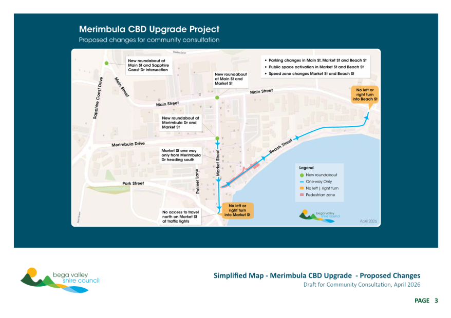
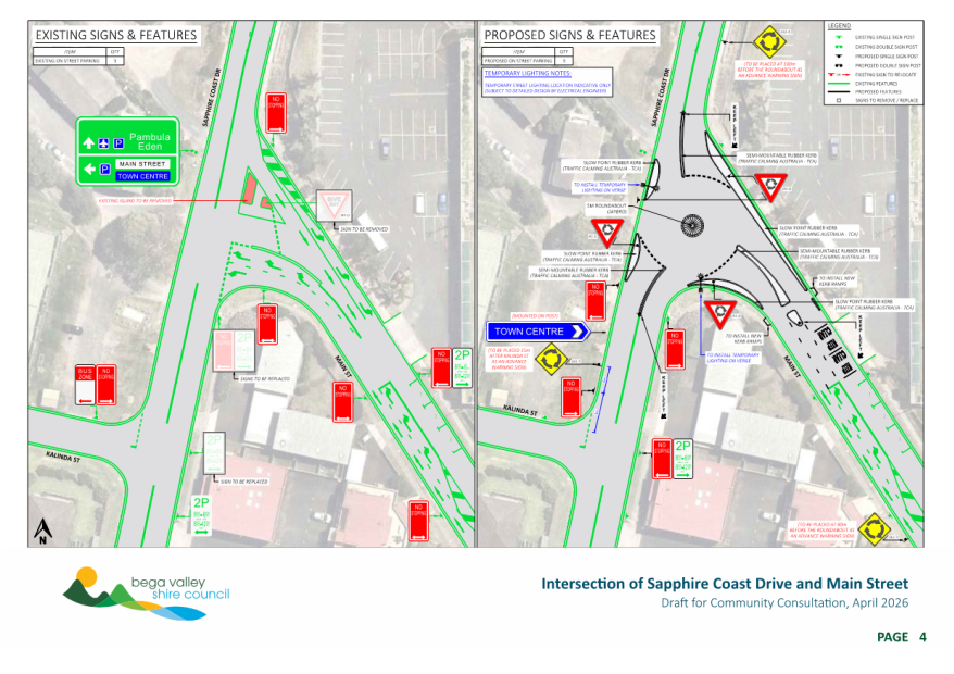
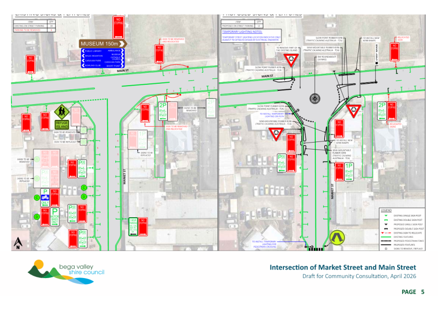
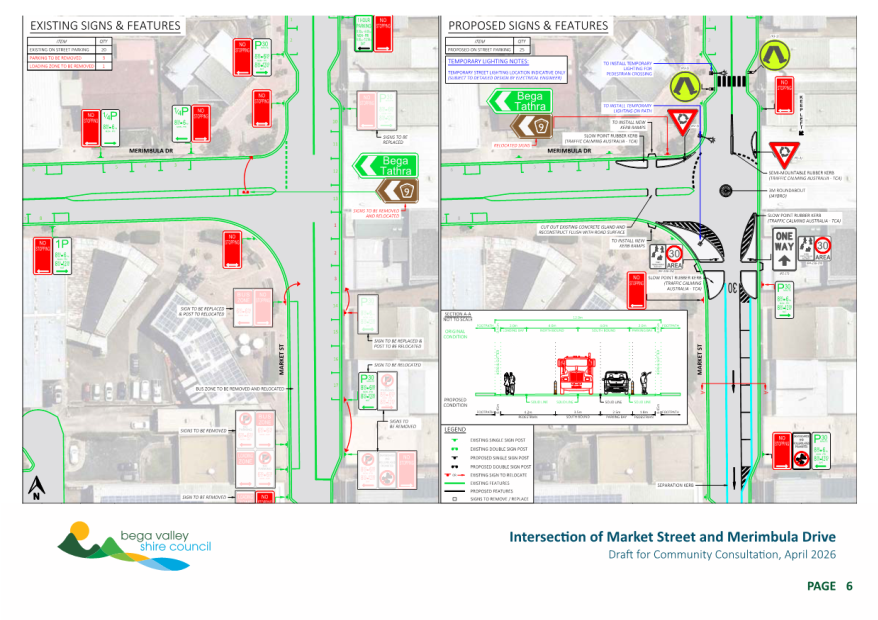
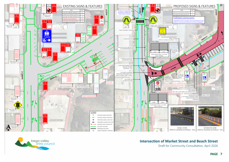
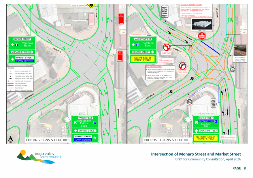
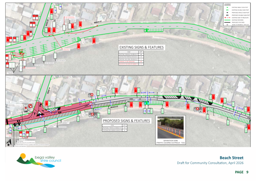
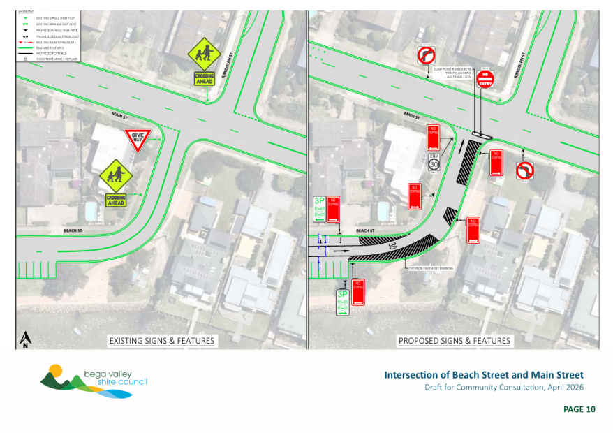
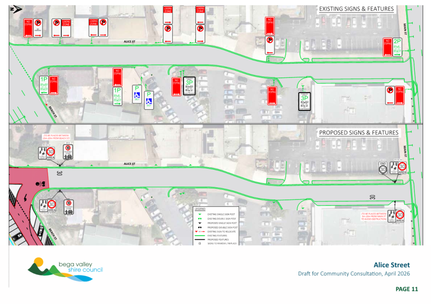
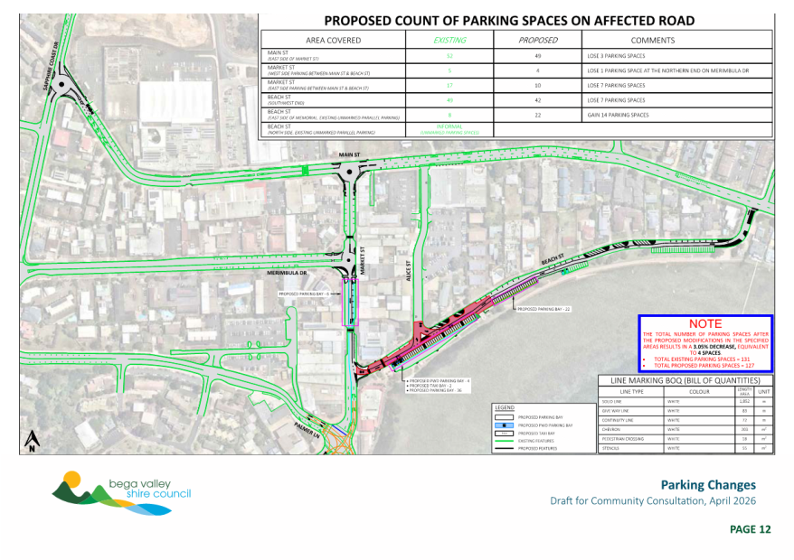
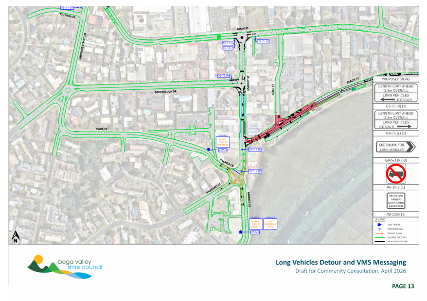
|
Item 9.2 |
9.2. Wolumla Floodplain Risk Management Study and Plan final findings
The final findings of the Wolumla Floodplain Risk Management Study and Plan following public exhibition are now ready for Council’s formal endorsement.
Director Infrastructure
1. That Council endorse the final findings and recommendations of the Wolumla Floodplain Risk Management Study and Plan and the corresponding Map Compendium (all dated 3 March 2026) as the best available flood information and measures for use in managing the flood risk within the identified catchment area
2. That a copy of the final endorsed Wolumla Floodplain Risk Management Study and Plan and the corresponding Map Compendium be published on Council’s website, provided to Council’s Local Emergency Management Committee and the State Emergency Service for their information.
Executive Summary
The final Wolumla Floodplain Risk Management Study (FRMS) and Plan (FRMP) findings are now available for formal endorsement following public exhibition and evaluation of submission comments.
Once finalised and endorsed, the Floodplain Risk Management Study and Plan will form the technical basis and strategic list of actions for mitigation of floodplain risk within the Wolumla Creek catchment to eliminate ad-hoc decision making.
Background
On 28 January 2026, Council resolved that the draft findings of the Wolumla Floodplain Risk Management Study and Plan be placed on public exhibition from Saturday 1 February 2026 to Sunday 1 March 2026.
Four submissions were received at the close of public exhibition and were considered in the finalisation of the final reports being presented to Council for formal endorsement. The submission content was evaluated, and minor changes were made to the final Floodplain Risk Management Study. No changes were necessary for the final Floodplain Risk Management Plan or Map Compendium.
Options
1. To formally endorse the final Wolumla Floodplain Risk Management Study and Plan findings.
· This is the preferred option as it aligns with Council’s Community Engagement Strategy, meets the requirements of the 2023 NSW Floodplain Risk Management Manual, provides a list of considered actions that eliminates ad-hoc decision making and activates protections under s733 of the Local Government Act.
2. To not endorse the final Wolumla Floodplain Risk Management Study and Plan findings.
· This is not the preferred option as it minimises community input, validation and ownership of the final findings and does not allow Council to meet its obligations under the 2023 NSW Floodplain Risk Management Manual or activate protections under s733 of the Local Government Act.
Community and Stakeholder Engagement
Internal and external stakeholder engagement has occurred in the development of the draft Wolumla Floodplain Risk Management Study and Plan findings in accordance with the IAP2 Participation spectrum and Council’s Community Engagement Strategy. Similarly, stakeholder engagement was completed during the previous Flood Study phase.
Engagement undertaken
An internal technical working group comprising staff from Assets and Technical Services and Planning and Sustainability provided input into the consultant technical brief. During the initial Wolumla Flood Study public exhibition period, an attempt was made to secure a community representative from within the catchment to support the project, without success. Despite a resident indicating an interest during the community survey, they declined to submit a formal application upon receiving the relevant information package.
Staff from Department of Climate Change, Energy and Environment and Water (DCCEEW), as the funding partner representative, also provided technical input to the consultant brief as part of the relevant funding deed requirements and participated in the technical working group meetings.
The initial community engagement and data gathering for the flood study phase occurred between 17 May to 2 June 2024 using an online community survey hosted on Council’s website Have Your Say page. A dedicated project webpage was developed, and the community engagement period was promoted with media releases and social media posts. Door knocking was also conducted 29 May 2024 to gather additional responses during the initial community engagement period. The flood study was formally exhibited from 18 April to 18 May 2025 and finally endorsed 23 July 2025 by Council.
A project overview was also given at the Flood and Coastal Committee meetings held on 25 March 2025 and 20 November 2025.
The draft Wolumla Floodplain Risk Management Study and Plan documents were placed on public exhibition from 1 February to 1 March 2026 inclusive using an online community survey hosted on Council’s website Have Your Say page. During the public exhibition period, a community drop-in information session was held at the Wolumla Public School on 11 February 2026. The project team members and eight community members were in attendance. During the public exhibition period, four submissions were formally received via the Have Your Say website page, and the online community survey received 261 views. The submission contents were considered in the finalisation of the final Wolumla Floodplain Risk Management Study and Plan documents.
Minor modifications were made to the Floodplain Risk Management Study document. No changes were made to the Floodplain Risk Management Plan or corresponding Map Compendium that was placed on exhibition.
The modifications to the Floodplain Risk Management Study publicly exhibited are summarised following:
· Addition of a technical memorandum to the Appendices assessing the Wolumla Structure Plan impacts
· Additional discussion on the distribution of management measures was added to the engagement outcomes section
· Rainfall intensity increases were aligned with the adopted Flood Study throughout the report
· References were corrected
· Additional explanation of acronyms was added to the Glossary and Abbreviation tables
Engagement planned
Consultation via formal public exhibition and the invitation of public comment is the subject of this report. Community consultation regarding FRMS and FRMP outcomes and findings are a requirement of the NSW Government’s Flood Prone Land Policy and its Floodplain Risk Management Manual. This report details the finalised Floodplain Risk Management Study and Plan after consideration of submissions received at the close of the public exhibition period for final endorsement.
Following endorsement, it is proposed to provide the information to the Local Emergency Management Committee and the NSW State Emergency Service.
Financial and Resource Considerations
The project has been partly funded at a ratio of 2:1 (State/Council) under the NSW Government Floodplain Risk Management Program to a maximum grant amount of $120,000 excluding GST as managed by the Department of Climate Change, Energy, the Environment and Water (DCCEEW).
|
Item |
$ Excl GST |
|
Expenditure Detail |
|
|
Wolumla Flood Study and Floodplain Risk Management Plan |
$184,690 |
|
Total Expenditure |
$184,690 |
|
Source of Funds |
|
|
Drainage General Fund |
$64,690 |
|
NSW Floodplain Management Program |
$120,000 |
|
Total income available |
$184,690 |
|
Total Income available |
$184,690 |
|
Project Funding Shortfall |
$0 |
At the time Council decides to implement any infrastructure related management measures, there may be lifecycle costing impacts of doing so at the subsequent date.
Once a Floodplain Risk Management Study and Plan are adopted, the likelihood of securing external grant funding from programs such as the NSW Floodplain Management Grant Program are increased for the implementation or investigation of specific actions.
The five identified high priority actions within the Floodplain Risk Management Plan have estimated capital costs at current day dollars of up to $70,000.
The three identified medium priority actions within the Floodplain Risk Management Plan have estimated capital costs of $180,000.
The three identified low priority actions within the Floodplain Risk Management Plan have estimated capital costs of between $1.9 – $10m dependent on extent of works to be determined.
Of the eleven identified actions, six are non-infrastructure related at minimal to nil estimated cost.
The NSW Floodplain Management grant program typically requires scoping and feasibility studies for implementation projects that exceed $500,000. Funding is available through the program to undertake the relevant scoping and feasibility studies upon successful submission.
Legal /Policy
The project is being undertaken in accordance with the requirements of the NSW Floodplain Risk Management Manual 2023.
The manual was gazetted in June 2023 as the manual relating to the development of flood-liable land for the purposes of section 733 of the Local Government Act 1993. It replaced the former Floodplain development manual (2005).
In accordance with Section 733 of the Local Government Act 1993, floodplain risk management in urban and rural areas in NSW is governed by the NSW Government’s Flood Prone Land Policy and its Floodplain Development Manual.
Locally, NSW Government policy relating to land use is implemented through Council’s adopted Bega Valley Local Environmental Plan 2013 and the Bega Valley Development Control Plan 2013.
Part of the typical outcomes of a FRMS and FRMP are a review of structural and non-structural flood mitigation options. Some of the typical non-structural options arising from a FRMS and a FRMP include review of flood related planning controls, flood prone land policies and flood related development controls. The final mix of structural and non-structural options are developed with the assistance of community consultation at these subsequent stages. These outputs are then incorporated into Council’s planning Instruments, where necessary.
Council issues planning certificates under Section 10.7 of the Environmental Planning and Assessment Act 1979 to inform potential purchasers of planning controls and policies that apply to the subject land. The properties affected by flood hazards within the Wolumla Creek catchment were identified as part of the Flood Study to allow changes to planning certificates to be made.
There are several properties that do not currently have these flood related planning and development controls. This may occur because they are not flood prone, according to the definitions of the NSW Government’s Flood Prone Land Policy, or no detailed flood mapping has been undertaken in those areas. Some of these properties may have flood related planning and development controls applied after the adoption of the FRMS and FRMP.
Council also has obligations according to the terms and conditions of the grant funding agreement with DCCEEW that include the mandatory use of external consultants, co-publicity, whole-of-government access to the final products and a current handover date of 31 March 2026 for the project deliverables. It is permissible within the Floodplain Grant Management Program to submit grant milestone claims up to 3 months late upon advice which has already been made to DCCEEW.
S733 of the NSW Local Government Act 1993 affords councils exemption from liability where councils act in good faith and substantially in accordance with the principles contained in the relevant manual.
Impacts on Strategic/Operational/Asset Management Plan/Risk
Strategic Alignment
Completion of the Wolumla Flood Study and Floodplain Risk Management Plan delivers the following action from Council’s adopted Delivery Program 2022-25 - D.1.2.1 Continue Wolumla Flood Study and Floodplain Risk Management Plan.
The completed FRMS and FRMP will form the key technical and policy basis for decision making and implementation of the adopted FRMP. The completed FRMS and FRMP will allow Council to identify and manage the existing, continuing and future flood risk, hydraulic and hazard categories within the Wolumla Creek catchment. The FRMS quantifies options to manage the identified flood risks within the floodplain in a considered and strategic fashion. Strategic responses for land-use planning, asset planning, emergency response planning, environmental, social and economic impact management can then be formulated to address existing and future flood risk and incorporated into relevant key strategic documents. Once adopted, the FRMS and FRMP will provide relevant information for consideration in revising Council’s planning instruments, asset management plans, emergency management plans and Long-Term Financial Plan.
An adopted FRMS and FRMP also allow Council further access to funding for implementation of certain actions identified within the FRMP through the NSW Government Floodplain Management Program upon successful grant application. These grants are typically offered at a ratio of 2:1 NSW Government to Council funding.
Environment and Climate Change
The effect of climate change was considered in the development of the technical brief and draft flood study findings in accordance with the relevant technical requirements as defined by DCCEEW. Sea level rise was not considered since the Wolumla catchment is so far upstream from the ocean boundary for no sea level rise impact to occur as determined during the 2014 Bega and Brogo Rivers Flood Study and subsequent 2018 Bega and Brogo Rivers Floodplain Risk Management Study and Plan projects.
Economic
There are minor positive economic benefits from the completion of the recent Flood Study and current Floodplain Risk Management Study and Plan projects through the consumption of local goods and services during community engagement and public exhibition periods associated with travel, accommodation and venue hire.
The co-ordinated suite of actions and intelligence gained from the Flood Study, FRMS and FRMP projects are aimed at managing and mitigating flood risk where possible to reduce the economic impact on the community.
Risk
The adopted FRMS and FRMP and the implementation of the identified actions will allow Council and the community to manage its existing, continuing and future flood risk.
The Wolumla Floodplain Risk Management Study and Plan will allow Council to identify a co-ordinated set of measures to manage flood risk within the catchment. The development and implementation of a Floodplain Risk Management Plan will eliminate ad-hoc decision making that may magnify residual flood risk within the catchment.
A lack of community engagement on the draft Floodplain Risk Management Study and Plan findings may lead to sub-optimal outcomes for the project and community of interest.
Placing the draft FRMS and FRMP on exhibition for public comment is consistent with Council’s adopted Community Engagement Strategy and is a requirement of the floodplain risk management process. This consultation process ensures that the outcomes incorporate the views of the community. Any submissions made during the public exhibition period will be considered in the finalisation of the FRMS and FRMP.
Council has existing commitments according to the terms and conditions of the grant funding agreement with DCCEEW. Delays in finalisation of the FRMS an FRMP may lead to a breach of the funding agreement that could jeopardise the success of future floodplain risk management grant applications.
Social / Cultural
Floodplains are the commercial, social and environmental arteries of NSW. Transport and communication infrastructure are often located in floodplains which, as generally the more fertile areas are a base for a significant proportion of NSW agricultural activity and home to a large proportion of the NSW population. Regular flooding enhances agricultural productivity by increasing soil moisture, recharging groundwater and depositing fertile silt across the floodplain. However, flooding can also interfere with production, communication, transport, emergency management and agricultural practices, as well as affecting property and potentially leading to loss of life. Therefore, development and management of floodplains need to consider a broad range of issues, including balancing the benefits of occupying the floodplain against the costs.
The findings, recommendations and implementation of the adopted FRMP will form the technical and policy basis for the management of social, cultural and economic impacts.
The suite of measures identified during the FRMS and FRMP project will minimise the financial and social disruption to the local community as a result of significant flood/storm events as the risk management actions are implemented.
Attachments
1⇩. Wolumla Floodplain Risk Management Plan for adoption
2⇩. Wolumla Floodplain Risk Management Study and Plan Map Compendium for adoption
3⇩. Wolumla Floodplain Risk Management Study for adoption
4⇩. Wolumla Floodplain Risk Management Study and Plan public exhibition submissions summary and responses
|
22 April 2026 |
|
|
Item 9.2 - Attachment 2 |
Wolumla Floodplain Risk Management Study and Plan Map Compendium for adoption |
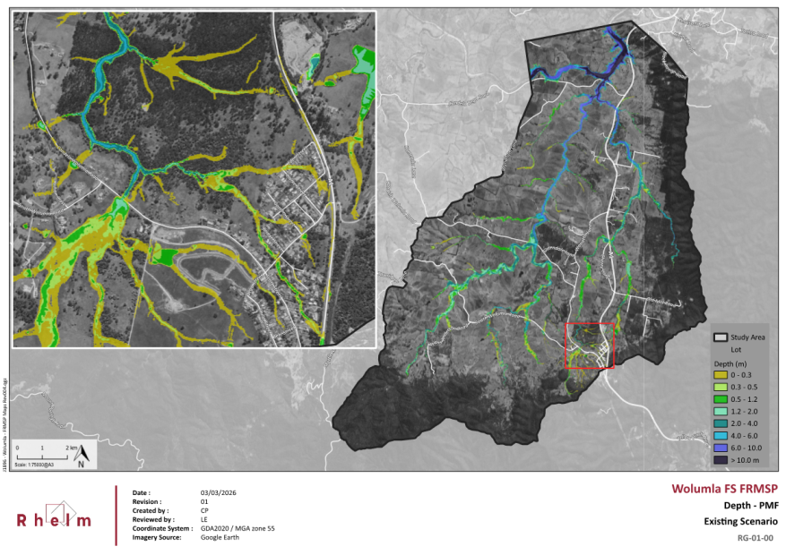

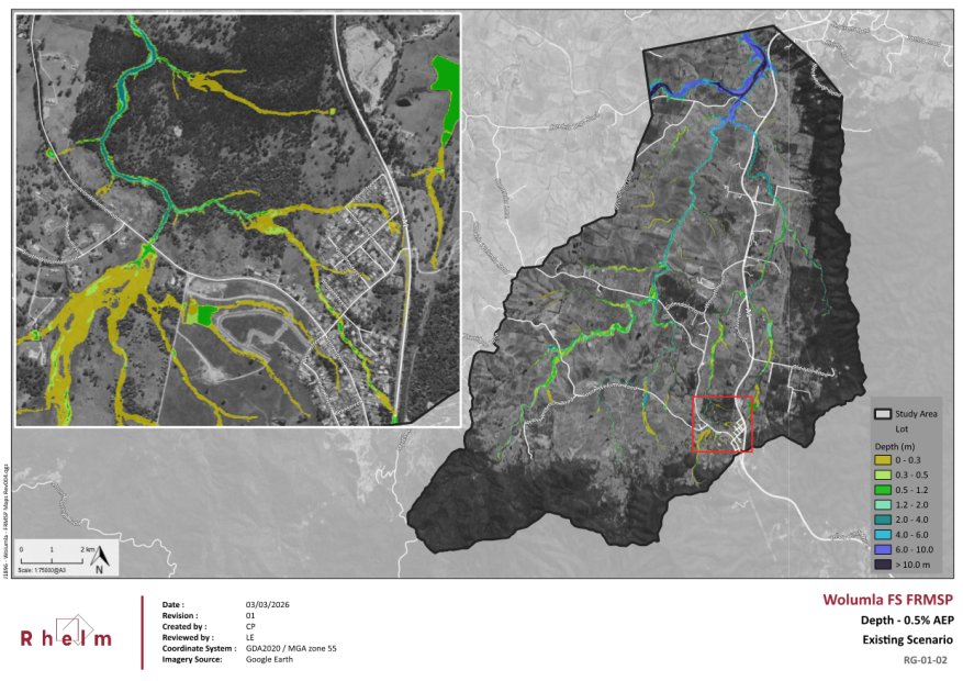
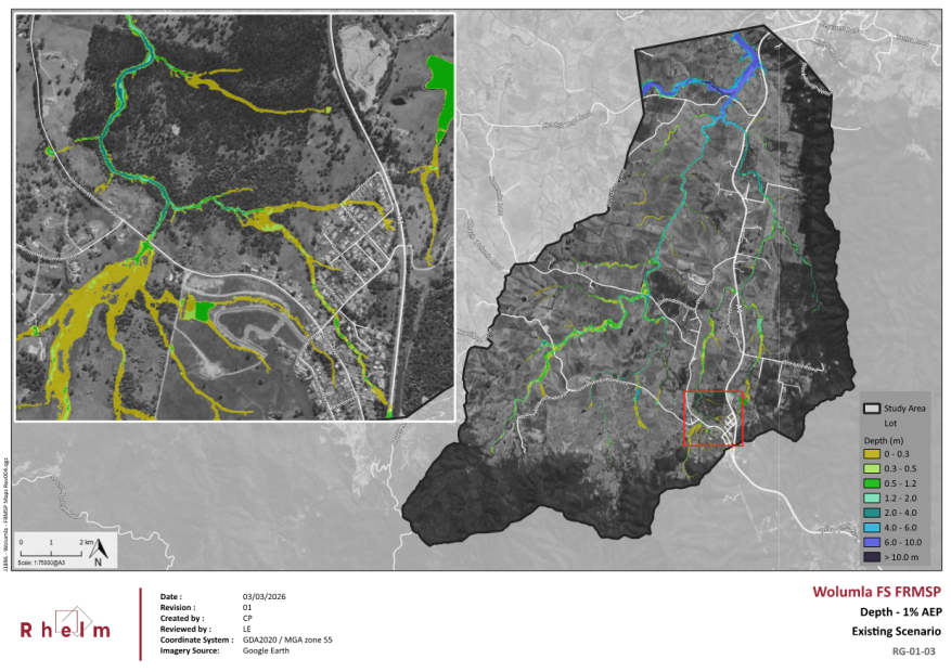

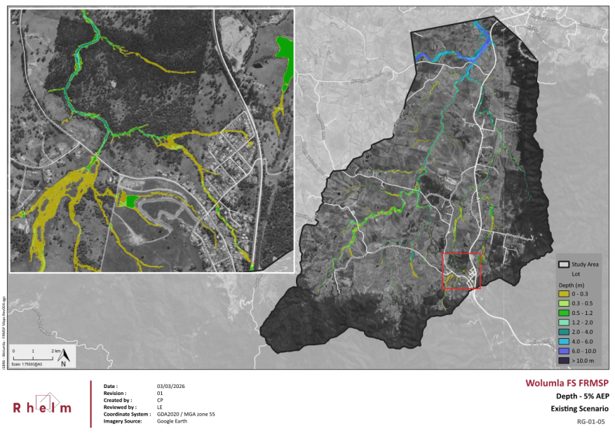

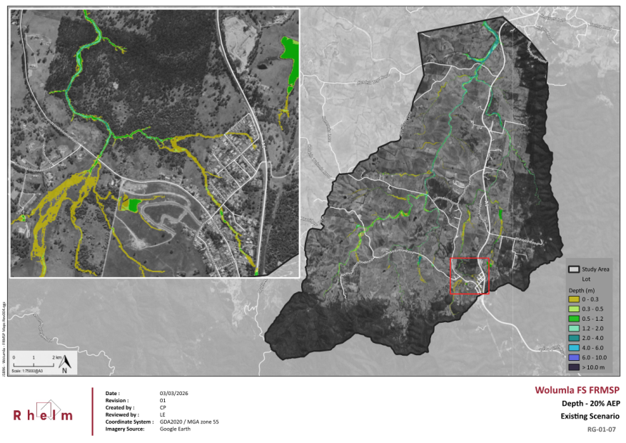
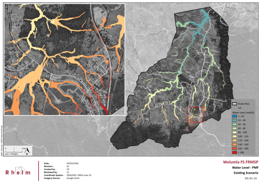
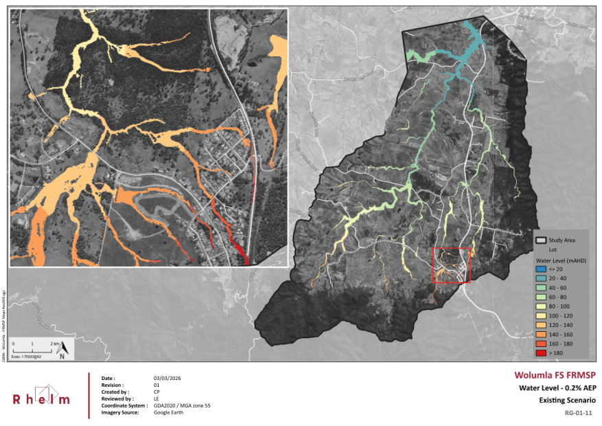


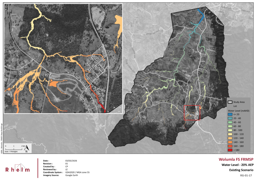
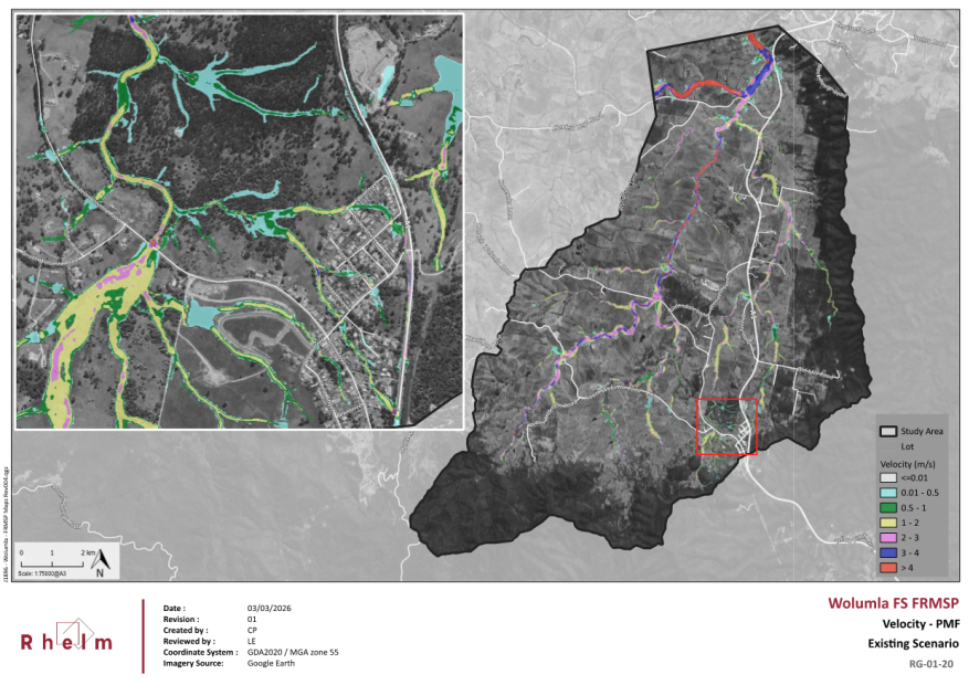


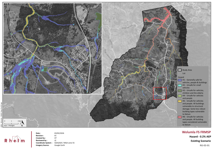


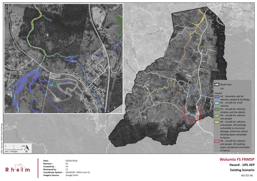
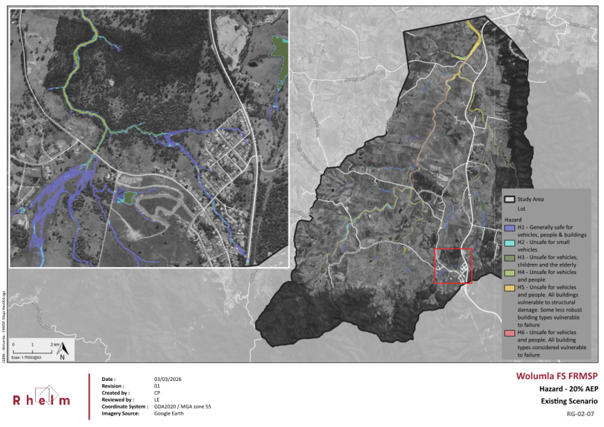
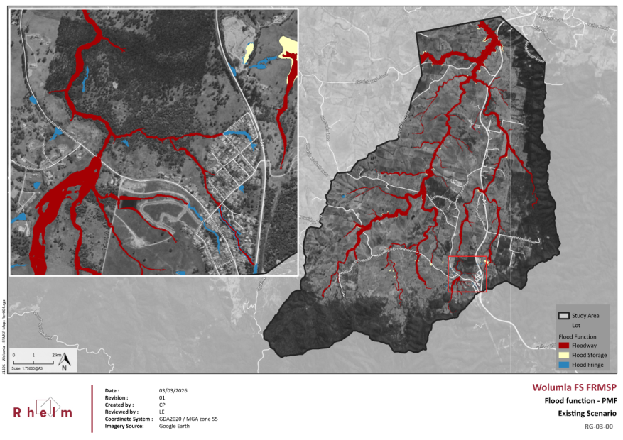
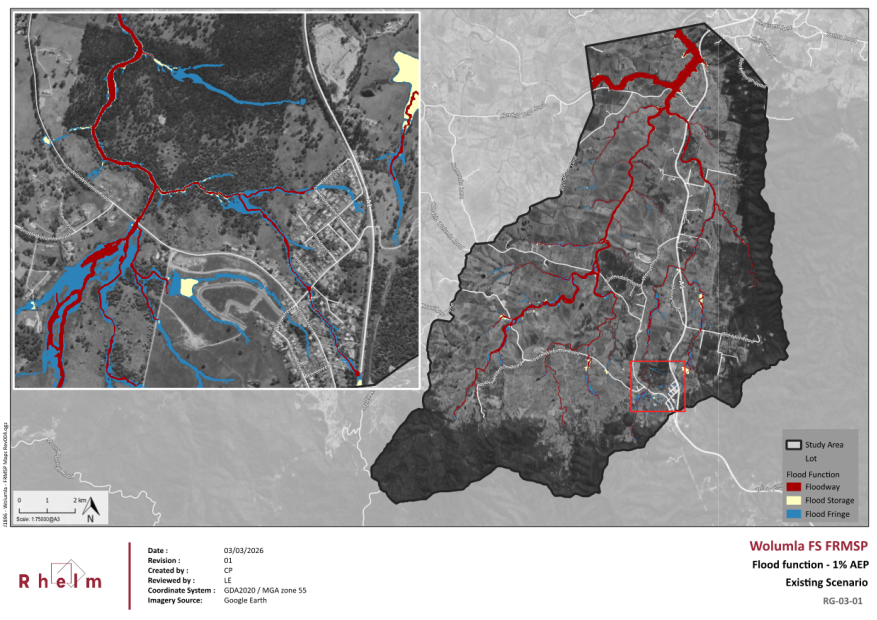
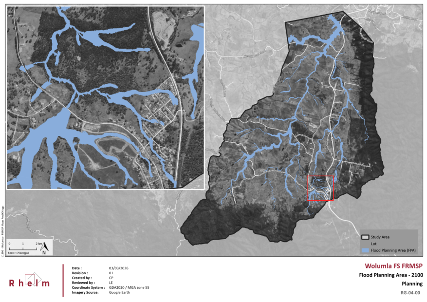
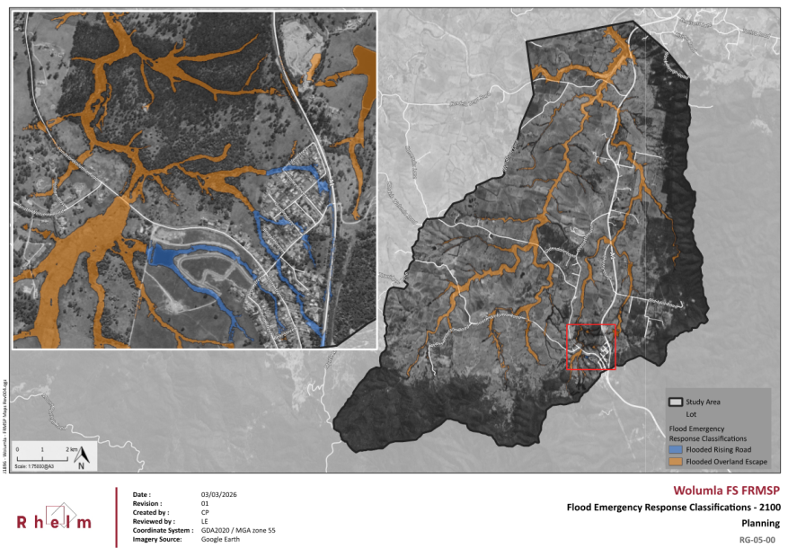
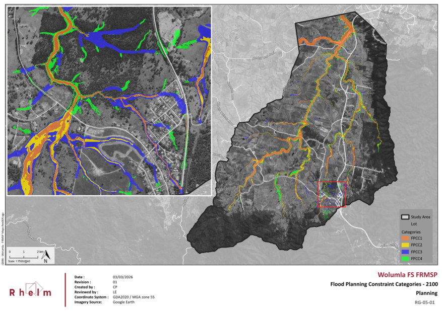
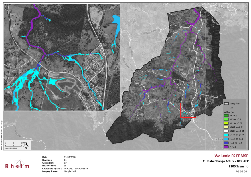
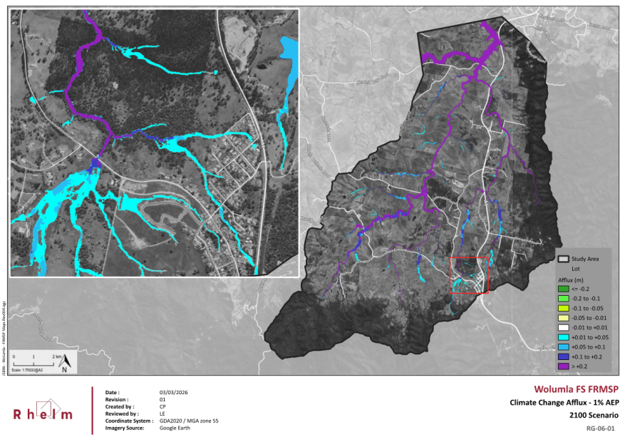
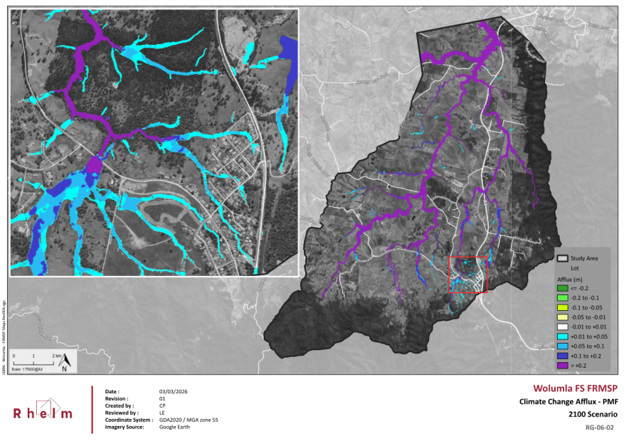
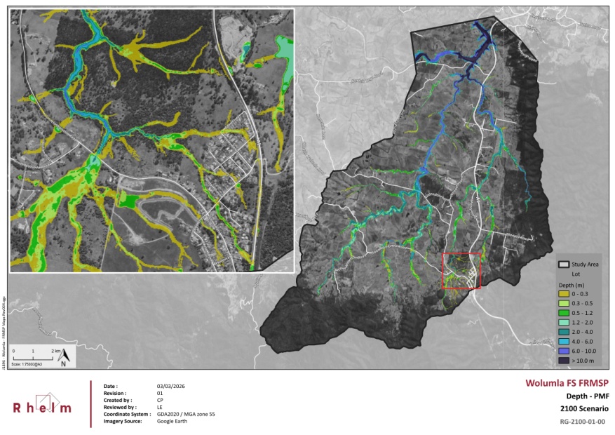


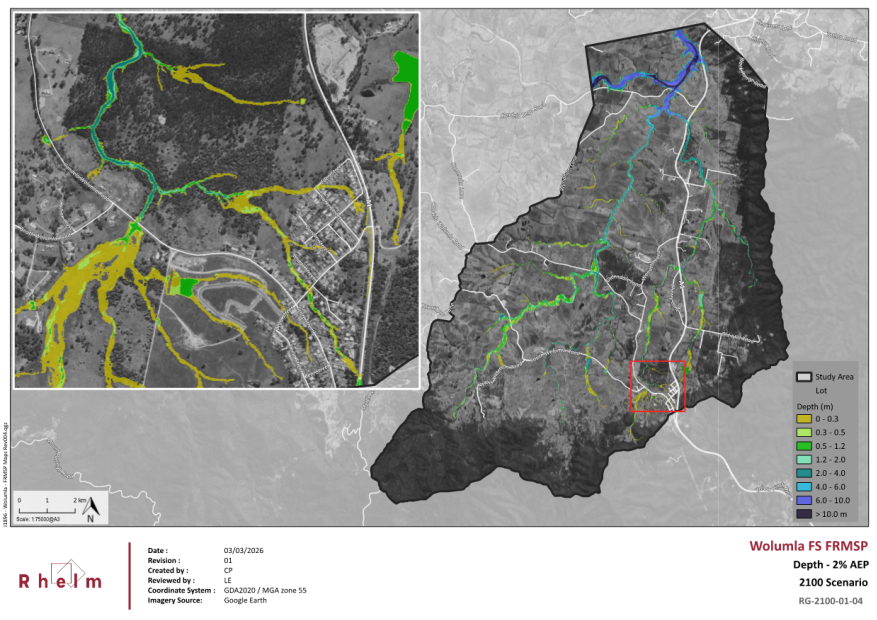


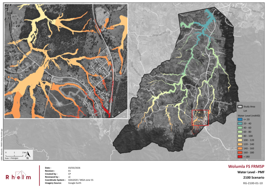


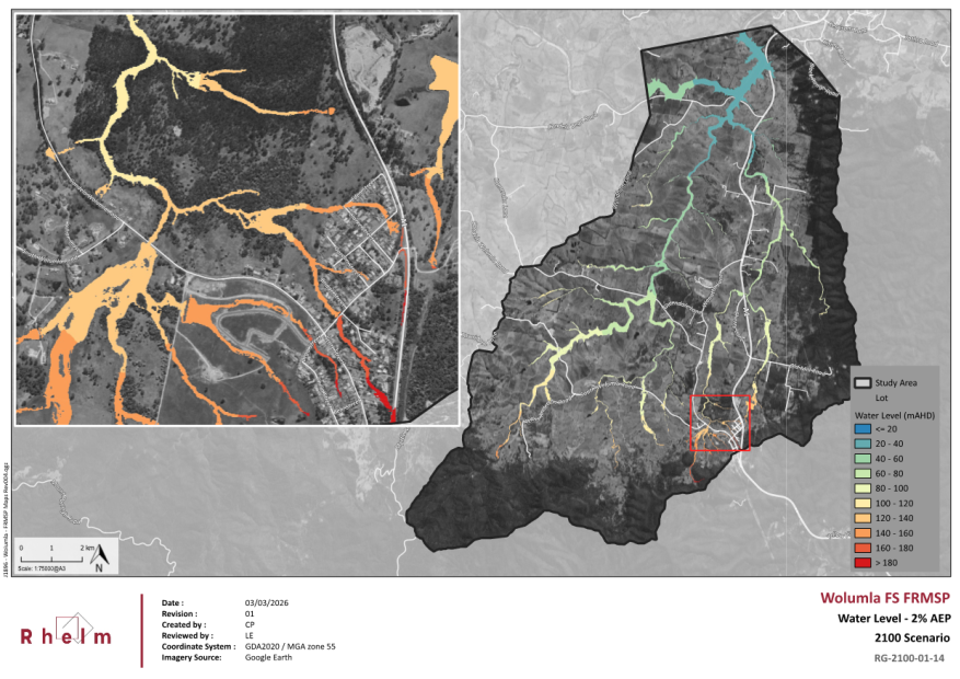
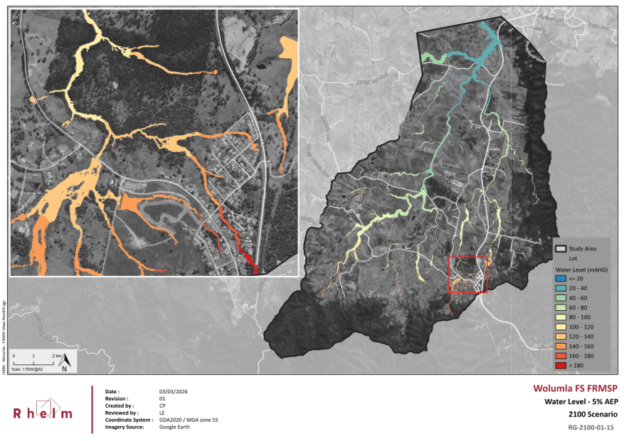
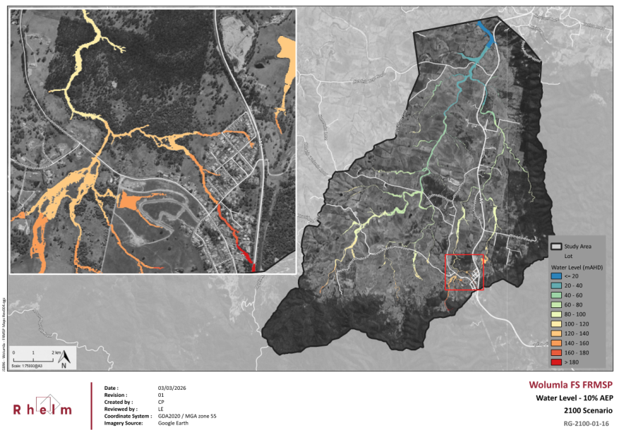
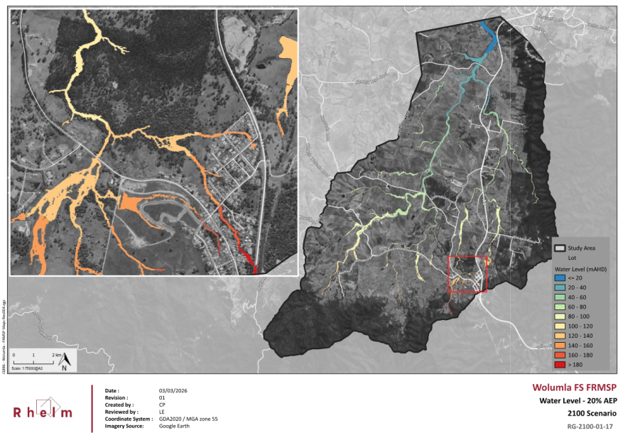
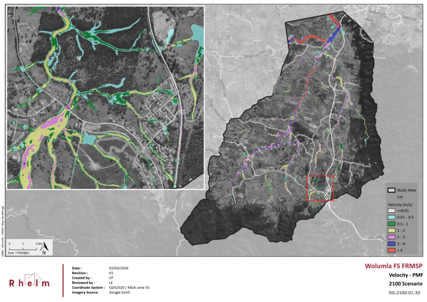
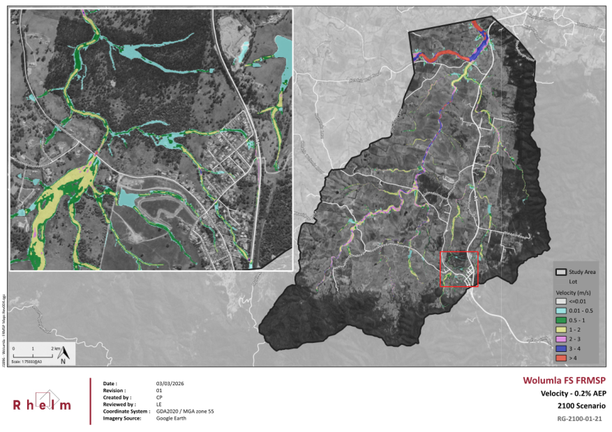


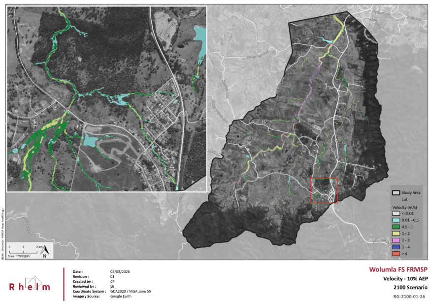

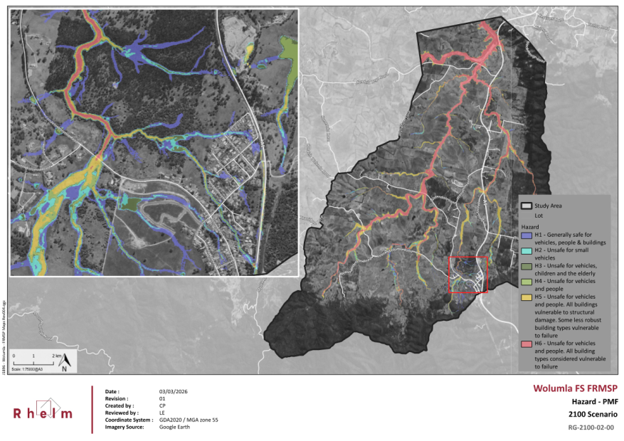
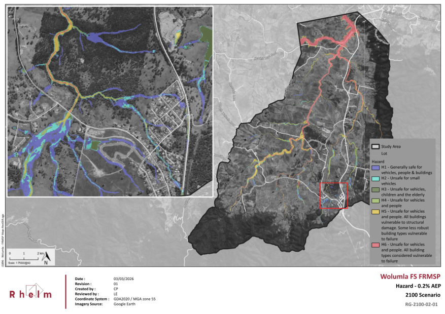


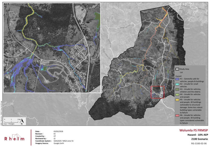
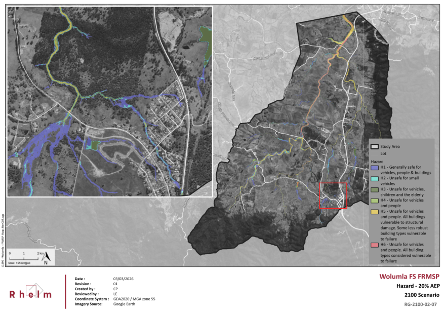
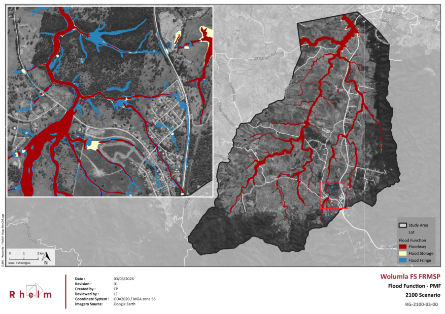
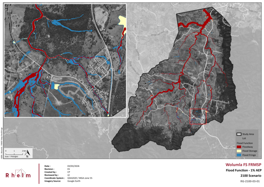

|
22 April 2026 |
|
|
Item 9.2 - Attachment 4 |
Wolumla Floodplain Risk Management Study and Plan public exhibition submissions summary and responses |
|
Item 9.3 |
9.3. Request for Tender (RFT) 2526-047 Supply & Install Guardrail - Multi Year Programme
This report outlines the evaluation of RFT 2526-047 supply & install guardrail – multiyear programme.
Director Infrastructure
2. That authority be delegated to the Chief Executive Officer to execute all necessary documentation, approve contract variations up to the available allocated budget and authorise the extension of the contract for the further term/s in accordance with the contract.
3. That all tenderers be advised of Council’s decision.
Executive Summary
Bega Valley Shire Council sought tenders from suitably qualified commercial contractors for the supply and installation of guardrail at various locations throughout the Shire. These works form part of a multi‑year programme, with specific sites to be delivered as identified in Council’s annual works programs and through individual work orders issued during the contract term.
The contract was advertised with an initial term of three years, with options for up to two further one‑year extensions, exercisable at Council’s discretion to support continuity of service and long‑term asset management objectives.
The evaluation of all conforming submissions has now been completed in accordance with the approved evaluation plan and Council’s procurement requirements. This report presents the outcomes of that evaluation and provides a recommendation for Council’s consideration regarding the preferred tenderer for the proposed contract.
Background
Council invited tenders from suitably qualified contractors for supply and install guardrail across the Bega Valley Shire. The initial contract is to commence in 2026 and to establish a three-year term schedule of rates contract. Tenders were advertised in Bega Valley Shire Council (BVSC) VendorPanel system on 5 February 2026. At the close of the tender period at 12.00pm on 26 February 2026, three submissions were received.
The tender submissions were evaluated according to price (60%) and non-price (40%) criteria. Information provided by tenderers within their tender submission, in particular price information, is ‘commercial-in-confidence’ and is included in the attached confidential memorandum.
Options
1. Accept the recommended tender as outlined in the confidential attachment. This is the preferred option.
2. Reject all tenders and re-advertise the project in the market. This is not a recommended option due to timing impacts to deliver the 2025-26 guardrail program and future 2026-27 program.
3. Reject all tenders and negotiate with any person (whether or not the person was a tenderer) with a view to entering into a contract in relation to the subject matter of the tender. This is also not the preferred option due to timing impacts to deliver this year’s relevant guardrail program during the 2025-26 and relevant project dependencies for co-ordination of associated activities.
Community and Stakeholder Engagement
Internal engagement is undertaken with stakeholders from Infrastructure Directorate through various communication channels, and collaboration meetings with key stakeholders
Engagement undertaken
In alignment with Bega Valley Shire Council’s community engagement toolkit, this project is deemed to be low complexity with ‘inform’ level of engagement. Bega Valley Shire Council staff will use a combination of online and offline existing communication tools through Bega Valley Shire Council’s media team to provide relevant community updates of minor disruption (if applicable) prior to activities being undertaken.
Engagement planned
Internal engagement will be undertaken internally with other stakeholders within the Infrastructure Directorate through various communication channels, and collaboration meetings with key stakeholders.
The community will be notified via a media release for the specific sites from the Council’s communications team after a contract is issued for these works. The media release will detail the expected construction programme and impacts including the anticipated timeframe for road closure.
Financial and Resource Considerations
Please refer to Budget Implications table contained within Confidential Memo.
Legal /Policy
The tender process conducted for RFT 2526-047 was undertaken in accordance with Section 55 of the Local Government Act 1993, part 7 of the Local Government (General) Regulations 2021 and Section 171 of the Local Government Regulations. Australian Standard AS4920-2003 General conditions of contract for the provision of asset maintenance and services (Principal’s version) applies to this Contract.
Impacts on Strategic/Operational/Asset Management Plan/Risk
Strategic Alignment
This program aligns with Bega Valley Shire Community Strategic Plan 2042 (2025 Revision) and Delivery Plan 2025-2029:
D. Our Infrastructure: Our infrastructure complements our natural surroundings and character while enhancing the lives of our community.
Strategic Objective: Our transport network supports our community to work, learn and socialise.
Strategy D.5 Deliver public and community transport options and improve highway connectivity.
Strategy D.6 Our transport Network makes it easy to move through and beyond the shire.
Environment and Climate Change
The recommended contractor’s approach supports Council’s environmental and climate objectives by minimising vegetation disturbance, managing soil and water impacts through appropriate erosion controls, and reducing emissions via efficient scheduling, recycling of removed materials, and the use of durable guardrail systems that lower whole‑of‑life resource consumption.
These practices help protect air, soil and water quality, avoid irreversible environmental harm, and ensure long‑term benefits for future generations.
The programme also aligns with Council’s Clean Energy Plan and Climate Resilience Strategy by reducing operational emissions, supporting responsible resource use, and improving the resilience and sustainability of the Shire’s road network.
Economic
The guardrail programme delivers several positive economic impacts, including supporting local employment through ongoing multi‑year work, providing business opportunities for local and regional suppliers, and stimulating the local economy through contractor spending on labour, materials and services.
Improved road safety reduces the economic costs of crashes, including emergency response, repairs, and productivity losses, providing long‑term savings for the community.
The use of durable materials and efficient installation methods also reduces whole‑of‑life maintenance costs for Council, leading to more sustainable asset management and better value for public funds.
Additionally, scheduling works over multiple years provides cost certainty, encourages competitive pricing, and improves fiscal planning for Council.
Risk
The risk assessment identified key risks including construction safety hazards, traffic management impacts, environmental disturbance, cost overruns and delays, and the risk of sub‑standard installation leading to future asset failures.
The recommended contractor mitigates these risks through demonstrated safety systems, qualified and experienced personnel, and established traffic control procedures that minimise disruption to road users.
Their methodology includes environmental controls to protect soil and waterways, along with proven quality assurance processes that reduce the likelihood of defects or rework. Clear scheduling, resource planning and cost‑control measures further limit financial and delivery risks.
Social / Cultural
The guardrail programme supports positive social and cultural outcomes by improving road safety for all community members, reducing the likelihood and severity of crashes, and enhancing public confidence in the transport network.
Safer roads contribute to community wellbeing, accessibility, and equity—particularly for vulnerable users such as young drivers, older residents, and visitors unfamiliar with local roads.
Delivering works with minimal disruption and maintaining clear communication with affected communities helps preserve social cohesion and respect for local cultural values. In rural and regional areas, reliable road safety infrastructure also supports social connectivity, ensuring residents can access essential services, employment, and cultural activities.
Attachments
1. RFT 2526-047 -Confidential Memorandum to Councillors (Confidential - As this attachment contains commercial information of a confidential nature that would, if disclosed (i) prejudice the commercial position of the person who supplied it; or (ii) confer a commercial advantage on a competitor of the Council; or (iii) reveal a trade secret as per Section 10A(2)(d) of the Local Government Act 1993.
Although the above relates more explicitly to the discussion of closed business, it also forms part of the basis of justification as to why information relied upon in informing the public decisions made by Council are kept confidential. To consider this confidential material in open Council would be, on balance, contrary to the public interest (as defined in Section 14 of Government Information Public Access (GIPA) Act 2009) as it would potentially disclose private business information provided by tenderers in a confidential tender process and would also impact Council’s position in relation to its consideration, therefore impacting the tender process. This meets the requirements of Sect 10 D of the Local Government Act 1993 if Council were to close the meeting to discuss the details of individual tenderers.
|
Item 9.4 |
9.4. Draft Playspace Improvement Plan
The Playspace Improvement Plan provides a guide for the future planning, prioritisation, and provision of playspaces across the shire, and is presented for Council endorsement.
Director Infrastructure
1. That Council endorse the attached draft Playspace Improvement Plan.
2. That Council note that the future works program is subject to annual review through the Delivery Program and the long-term financial plan, that its implementation is dependent on a combination of Council funding and external grants.
3. That it is noted that further community engagement will occur for all proposed playspace projects prior to commencement.
Executive Summary
The Playspace Improvement Plan provides a guide for the renewal, upgrade, and rationalisation of playspaces across the shire. As a supporting document to the Recreation Strategy, it ensures future investment is equitable, sustainable, and aligned with changing community needs.
The plan responds to a network of thirty-eight playgrounds of varying age, condition, and play value. Analysis shows many are aging, there is oversupply in some locations, and undersupply in areas such as Bega, Tura Beach, and Wolumla. Demographic insights highlight the importance of prioritising areas with urban growth and communities experiencing socio economic disadvantage.
The plan introduces a balanced playspace hierarchy, increasing the number of district level playspaces to support higher value, inclusive, and well equipped playspaces while reducing under-utilised or overlapping local sites. Nature play and inclusive design are key priorities, reflecting strong community preferences for creative, age diverse, and accessible play experiences.
The plan draws on several information sources, including community consultation feedback, current and projected population and demographic data, industry benchmarks for asset management and service provision, and Council’s own asset portfolio and capacity to manage a large network across a broad shire with a relatively small population base.
A staged 2027-2036 future works program identifies priority projects, supported by a proposed capital budget of $3.5 million, which is dependant external funding. Having an endorsed Playground Improvement Plan strengthens and supports grant funding applications.
The plan sets a direction for delivering modern and engaging playspaces that enhance community wellbeing and ensure fair access to quality play opportunities across the Bega Valley Shire.
Background
RecCreate – A Strategy for Recreation in the Bega Valley Shire was adopted by Council at its December 2025 meeting. One of the key actions identified in the strategy (Action 7) is the development of an Asset Improvement Plan for play facilities to define asset hierarchy, service levels, prioritise projects, and provide a forward-looking strategic approach to managing playspaces.
The success measure for this action is the development and implementation of the Playspace Improvement Plan. The draft Playspace Improvement Plan has been completed and, following Council endorsement, will guide the implementation of playspace development across the shire.
Options
1. Option 1: Endorse the draft Playspace Improvement Plan (recommended)
Endorsing the plan provides clear direction, improves service, supports long term and financially sustainable asset planning, strengthens opportunities for external funding, and aligns delivery with community expectations for higher quality, inclusive, and nature based playspaces. While endorsement may raise community concerns where rationalisation or repurposing of existing playgrounds is proposed, these changes are needed to achieve broader network‑wide play improvements.
2. Option 2: Do not endorse the draft Playspace Improvement Plan
Not endorsing the plan leaves a strategic gap, perpetuates ad-hoc investment, weakens Council’s ability to secure external funding, delays improvements in underserviced areas, and maintains maintenance pressures across an ageing playground network. However, not endorsing the plan provides Council with additional time to seek further analysis, consultation, or refinement before proceeding.
Community and Stakeholder Engagement
Engagement undertaken
Community consultation undertaken during the development of the Recreation Strategy and through an online survey from 1 July to 17 August 2025 (Help Us Shape The Future Of Our Playgrounds) has informed this plan. There is notable desire to make some changes and provide an updated and more interesting network of playspaces.
The community consultation campaign specifically related to playgrounds ‘Help Us Shape The Future Of Our Playgrounds’ received 504 responses. The survey sought to understand current playground usage, preferences, and priorities for future development. The Consultation Report is available on the project website here, Project Page - Playground Improvement Plan.
The outcomes of the survey and the development of the draft Playspace Improvement Plan were presented at a workshop with Councillors on 4 March 2026.
The feedback highlighted strong community support for inclusive, well-equipped, and creatively designed playgrounds located in central areas. There was also a clear focus towards nature play.
Engagement planned
The community will have the opportunity to comment on proposed playspace renewals and upgrades as each project gets underway and site-specific concept plans are developed underway. Their views will be considered during the early design process. For all projects, a final concept plan will be reported to Council for endorsement.
The level of community engagement will be linked to the classification of the playspace. The development of a regional playspace will attract a broader level of community engagement when compared to the development of a local playspace.
Financial and Resource Considerations
The future works program presented in the Playspace Improvement Plan includes capital expenditure of $3,503,100 to support the upgrade and renewal of sixteen playspaces during a 10-year planning period.
Of this total investment it is budgeted that:
• $1,405,100 will be funded by Council, and
• $2,098,000 will be supported through project grant funding.
|
Item |
$ Excl GST |
|
Expenditure Detail |
|
|
Playspace Improvement Plan Capital Works |
$3,505,100 |
|
Total Expenditure |
$3,505,100 |
|
Source of Funds |
|
|
BVSC Funding |
$1,405,100 |
|
Confirmed Grants (MLCIP) |
$750,000 |
|
Total income available |
$3,503,100 |
|
Total Project Capital Cost |
$3,505,100 |
|
Total Available Construction Funding |
$2,848,000 |
|
Project Funding Shortfall (unconfirmed future grants) |
$1,348,000 |
Financial Option Impacts | Life Cycle Costing
Endorsement of the Playspace Improvement Plan does not, in itself, create any financial commitments. Lifecycle costs for individual projects will be reported to Council at the time the corresponding concept design is presented for adoption.
The figures below demonstrate an annual lifecycle cost of $272,000 for the sixteen playspaces nominated for renewal in the future works program. Play equipment is high service cost and relative short lifecycle assets. This shows the importance and impact of considering whole of life costs when planning capital works for short lifecycle and high service costs assets.
|
Ongoing Financial Impacts |
$ Excl GST |
|
Capital Investment | Renewal, Upgrade (proposed 16 projects value 10 years) |
$3,505,100 |
|
Annual maintenance and operational costs (avg $6,000 pa / playspace. Applied to sixteen projects over 10 years) |
$96,000 p.a. |
|
Annuals depreciation costs ($3.5m capital investment depreciated over 20-year lifecycle) |
$176,000 p.a. |
|
User charges (annual income) |
Nil |
Legal /Policy
The development of the Playspace Improvement Plan relates directly to the adopted policy 1.08 Parks, Aquatics and Recreation. The policy states:
Parks, Aquatics and Recreation assets are facilities and items that provide access and amenity to enable people to enjoy the environment we live in and contribute to individual and community health and well-being.
The broad scope of this policy is to see that Council managed Parks, Sportsgrounds, Pools, Playgrounds & Skate Parks, Natural Areas, and Recreational Marine assets are managed, fit for purpose, and deliver the benefits outlined above to the community.
Impacts on Strategic/Operational/Asset Management Plan/Risk
Strategic Alignment
The Playspace Improvement Pan supports the goals of the Bega Valley Community Strategic Plan:
Section D: Our Infrastructure, D.4 Plan for, develop and maintain sport and recreation spaces and facilities.
The development of the Playspace Improvement Plan is a direct action from RecCreate – A Strategy for Recreation in the Bega Valley Shire to development an Asset Improvement Plan for play facilities (Action 7).
Environment and Climate Change
The Playspace Improvement Plan reduces environmental impacts by prioritising natural materials and nature-based play, increasing tree planting, and limiting rubber surfacing to higher use sites. All new playspaces will undergo environmental assessment through the Review of Environmental Factors process.
Economic
Well-designed, inclusive playspaces can support tourism by integrating with other recreation facilities and activities. This demonstrates the broader community value of high-quality district and regional playspaces, which enhance the experience for both residents and visitors and contribute to local economic and tourism outcomes.
Risk
Endorsing the Playspace Improvement Plan reduces strategic, financial, operational, and reputational risks by providing a clear framework for prioritising playspace investment. It mitigates the risk of ad hoc or speculative decision making and sees renewal funding is directed to the highest need locations. Ongoing community engagement and mandatory REF assessments mitigate social, environmental, and compliance risks during implementation.
The Playspace Improvement Plan improves financial sustainability through adjusting provision by prioritising high‑use locations, rationalising under-utilised sites, increasing cost‑effective nature‑based play, and reducing maintenance costs. It also strengthens Council’s ability to secure external grants, lowering reliance on Council funding.
Social / Cultural
Endorsing the Playspace Improvement Plan supports planning for inclusive playspaces that strengthen community wellbeing and social connection. It prioritises areas of need, promotes equitable access to quality recreation, and ensures ongoing community engagement so local values are reflected in future playspace design and delivery.
Attachments
1⇩. Draft Playspace Improvement Plan
Council 22 April 2026 |
Item 9.5 |
9.5. Bega Valley Local Transport Forum 17 March 2026
This report provides the recommendations of the extraordinary Bega Valley Local Transport Forum (LTF) meeting held on 17 March 2026.
Director Infrastructure
That Council adopt the recommendations of the extraordinary Bega Valley LTF meeting held on 17 March 2026 regarding the Merimbula CBD Upgrade project as outlined below:
Changes to drawings prior to community consultation
Sapphire Coast Drive and Main Street
· Roundabout sign closer to roundabout, it was previously located south side of Kalinda Street
· No right and left turn signs to be removed from the islands in Sapphire Coast Drive
Main Street and Market Street
· Removal of no right turn sign in Main Street
· Relocation of pedestrian crossing further south and inclusion of pedestrian crossing kerb blisters
Merimbula Drive and Market Street
• Inclusion of 30km gateway signage
• Line marking and signage
• Removal of loading zone opposite Hylands corner (below chemist). (Loading zone was included in drawings prior to consultation)
Market Street and Beach Street
• Loading zone retained at Twyford Hall and around the corner near the Salvation Army store
• Extended shared 10km Zone past Alice Street intersection
• Additional road pavement control marking to Beach Street entry
• Removal of 50km signage
Monaro Street, Market Street, and Palmer Lane
• Left hand turn only into Monaro Street, northbound Market Street at lights
• No Entry sign right to Market Street
• End of 30km sign Market Street
• South Bound Sign on Palmer Lane, right lane must turn right
• Variable Message Signs (VMSs) being installed to advise motorists of upcoming changes
Alice Street
• Additional 30km gateway signage
• 10km shared zone plus signage
Beach Street and Alice Street
• Revised car parking spaces
• Extended shared zone
• Installation of 30km Gateway signs
Beach Street and Main Street
• Inclusion of 30 km speed limit signage
• One way road pavement signage.
Executive Summary
The LTF is an advisory body incorporating technical review and is not a decision-making committee of Council. LTFs operate under delegation from TfNSW who are responsible for traffic management on all NSW roads. The LTF role is to advise Council on traffic management matters that relate to prescribed traffic control devices or traffic management facilities for which Council has delegated authority.
It is a requirement for Council to formally adopt the recommendations from the LTF prior to action being taken.
It is a requirement for minutes and agendas of the LTF meeting to be made publicly available as soon as practicable. More information can be found at https://www.begavalley.nsw.gov.au/For-Residents/Roads-Parking-and-Current-Works/Local-Transport-Forum
Background
The purpose of the extraordinary LTF meeting was to update the LTF on the proposed traffic changes and implementation works for the Merimbula CBD upgrade project. The previous meeting, held on 14 October 2025, presented initial drawings to the LTF for feedback. The project team subsequently reviewed this feedback and revised the drawings accordingly.
The updated designs were then considered at Council workshops, where various car parking options and amendments were explored. The updated drawings were presented to the LTF for review prior to them being presented for community consultation.
The following discussion took place:
Merimbula Drive and Market Street
The loading zone shown on the revised drawing opposite the Commonwealth Bank will be replaced with 2 car park spaces. Community feedback will be sought to see if carpark spaces or loading zone preferred.
Market Street and Beach Street
It was confirmed that the pavement from corner of Beach/Market Streets to Alice Street be painted a different colour to show it is 10km high pedestrian (HP) zone.
Monaro Street, Market Street, and Palmer Lane
It was suggested that a permanent advanced warning sign be installed that left lane must turn left from Market Street into Monaro Street (to avoid last minute lane change).
Alice Street
Having the speed zone reduced to 10km HP zone will make it a lot safer as cars will be reversing from the new 90 degrees car parking spaces in this zone.
Beach Street and Alice Street
It was requested that the single isolated 45-degree parking bay near the intersection of Alice/Beach Street be investigated as to whether 2 x parallel parking spaces could fit. The current existing configuration is parallel parking already.
The 10km speed zone is currently being reviewed by TfNSW and will be painted a different colour on the pavement as per above.
Options
1. Accept the recommendations provided by the LTF and resolve accordingly.
2. Reject the recommendations provided by the LTF and resolve accordingly.
3. Resolve on alternate or modified options raised by Councillors.
Community and Stakeholder Engagement
Engagement undertaken
No other engagement was undertaken in relation to this report.
Engagement planned
The presentation of this report to Council and the notification of outcomes to relevant stakeholders are part of the remaining engagement activities planned.
Financial and Resource Considerations
The financial and resource considerations associated with this report include staff time for preparation of the reports, attendance at the LTF and preparation of minutes. The Merimbula CBD Upgrade project is being funded through the Australian Government through the Investing in Our Communities grant program.
Legal /Policy
The legal and policy issues will be addressed through the application of conditions to manage public safety and traffic hazards via the LTF delegation from TfNSW.
Impacts on Strategic/Operational/Asset Management Plan/Risk
Strategic Alignment
The recommendations are in line with our road and reserve management policies.
Environment and Climate Change
There are minor positive environmental impacts climate change implications associated with the project implementation from reduced emissions through improved active transport activation.
Economic
There are no economic impacts associated with the approval of this report.
Risk
There is a mitigation of traffic and public safety risk by implementing the actions recommended by the LTF.
Social / Cultural
There are social and cultural outcomes associated with the approval of this report. The Merimbula CBD Upgrade project is intended to improve traffic safety, pedestrian access, public space activation and social amenity.
Attachments
1⇩. Local Transport Forum minutes of extraordinary meeting 17 March 2026
|
22 April 2026 |
|
|
Item 9.5 - Attachment 1 |
Local Transport Forum minutes of extraordinary meeting 17 March 2026 |

|
Council |
22 April 2026 |
Staff Reports – Organisational Services
22 April 2026
10.1 Acquisition of land for Bega Borefields............................................................. 466
10.2 Quarterly Budget Review Statement (QBRS) March 2026 (Q3 Review)........... 477
10.3 Certificate of Investment March 2026.............................................................. 503
10.4 Waiver of water connection charge - Bega Town Band Building (Canning St, Bega) 510
Council 22 April 2026 |
Item 10.1 |
This report seeks Council approval to progress acquisition of the required land interest for the Bega Bore Field, following extended good‑faith negotiations, to enable delivery of essential water supply infrastructure and long‑term water security.
Director Organisational Services
1. That Council acquire the required interest in land within Lot 1 DP 601304, Bega, for the purpose of constructing, operating and maintaining water supply bore infrastructure associated with the Bega Bore Field.
2. The Chief Executive Officer be delegated authority to negotiate the acquisition of interest in land within Lot 1 DP 601304, Bega, by agreement with the landowner on terms consistent with the Land Acquisition (Just Terms Compensation) Act 1991.
3. If the acquisition of easements cannot be completed by agreement within a reasonable timeframe, Council acquire the required interest in land within Lot 1 DP 601304, by compulsory process under the Land Acquisition (Just Terms Compensation) Act 1991, pursuant to sections 186 and 187 of the Local Government Act 1993, and do all things supplemental or incidental to, or consequential for, that purpose.
4. Council affixes the Seal of Council to any documents required to be sealed relating to the acquisition of interest in land within Lot 1 DP 601304, and that authority be delegated to the Mayor and Chief Executive Officer to execute those documents
5. Authority be delegated to the Chief Executive Officer to execute on behalf of Council any documents associated with the acquisition of interest in land within Lot 1 DP 601304, not requiring the affixing of the Seal of Council.
Executive Summary
Council approval is sought to progress the acquisition of easements within Lot 1 DP 601304, being land owned by the Bega Pony Club, to enable delivery of critical water supply infrastructure associated with the Bega Bore Field.
Technical investigations have confirmed the subject land as the preferred long‑term location for future bore infrastructure based on hydrogeological suitability, drought and flood resilience, and reduced contamination and salinity risk. While Council has engaged in good‑faith negotiations with the landowner for approximately 18 months, no mutually agreeable outcome has been reached. Further delay poses a material risk to Council’s ability to maintain a safe, secure and reliable water supply for Bega and surrounding communities.
Officers therefore recommend that Council resolve to progress acquisition of the required land interest, with compulsory acquisition as a last resort should agreement not be achievable within a reasonable timeframe.
Background
The Bega bore field was constructed in stages during the 1970s and 1980s and currently comprises six bores, of which five are presently in service. The existing bores are approximately 21 metres deep (Figure 1), spaced at intervals of around 40 metres, and connected to the transfer main supplying the High Street balance tanks. The bore field is located on land owned by Council and extends along the full length of the site.
A condition assessment undertaken by GHD in 2016 identified that the existing bores are approaching the end of their service life and will require refurbishment or replacement.
As part of subsequent investigation works, test bores were installed in January 2019 within Lot 1 DP 601304, being land owned by the Bega Pony Club, and were monitored throughout 2020. The results of this monitoring informed further technical investigations into the suitability of alternative bore locations to support long‑term water supply outcomes.
In response to the findings of the GHD assessment and subsequent monitoring, Council engaged SMEC Australia Pty Ltd to undertake a comprehensive assessment of the alluvial groundwater resource in the Bega area. The purpose of this assessment was to inform recommendations for the location, drilling, development and commissioning of new or replacement production bores. The assessment was finalised in June 2024 and is attached for the information of councillors.
The assessment identified the subject land within Lot 1 DP 601304 as a preferred location for future bore infrastructure based on hydrogeological suitability and long‑term water supply outcomes. In particular, the proposed bore locations were identified as optimal due to the increased depth of the aquifer (approximately five metres deeper than alternative sites), comparable flood resilience to the highest existing bore, proximity to existing water supply infrastructure, and their location upstream of the Brogo River confluence, thereby reducing salinity risk. A visual cross‑section illustrating the aquifer characteristics and the rationale for the proposed bore locations is provided below for the information of Councillors.
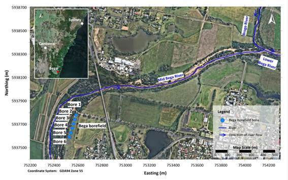
Figure 1: Existing Bega bores
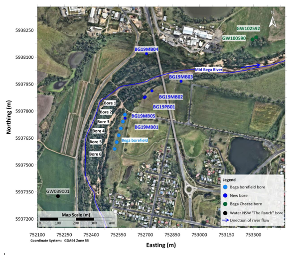
Figure 2: Future Bega bore field location
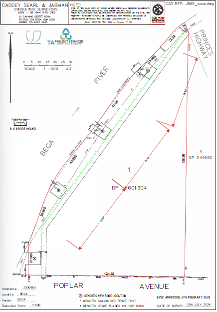
Figure 3: Proposed future Bega bores layout within Lot 1 DP 601304.
The Bega bore field is a critical component of Council’s water supply system and provides:
· A reliable groundwater source during periods of low surface water availability.
· Support for agricultural and industrial users.
· A key drought resilience measure and
· Improved resilience to climate variability and extreme weather events.
Maintaining and upgrading the bore field is essential to ensuring long-term water security for Bega and surrounding communities.
While Council acknowledges the importance of the Pony Club facilities to the local community and has undertaken good‑faith negotiations over an extended period, no mutually agreeable outcome has been reached. Discussions have now been ongoing for approximately 18 months, and further delay poses a risk to Council’s ability to progress essential water supply infrastructure.
Given the strategic importance of the bore field project and Council’s obligation to ensure a safe and reliable water supply, officers consider that continued negotiation is unlikely to achieve an outcome within a reasonable timeframe.
Options
The options available to Council are:
1. Proceed with acquisition of the required easements by agreement. If, following two years of good‑faith negotiations, agreement cannot be reached by September 2026, Council proceed to compulsory acquisition of the required land interest without further delay. Recommended.
2. Defer acquisition, noting this would delay delivery of critical water supply infrastructure and increase risk to long‑term water security.
Community and Stakeholder Engagement
Engagement undertaken
Council officers have undertaken extensive engagement with the Bega Pony Club over an extended period, commencing in September 2024 and continuing through to March 2026. Engagement has been undertaken in good faith and at multiple stages of the project to explore options to accommodate the Pony Club’s operational requirements while progressing essential water supply infrastructure.
Engagement activities have included:
· Initial written and verbal contact to arrange meetings and discuss future bore field requirements.
· Multiple face‑to‑face meetings with pony club representatives to explain the proposed bore locations, access requirements and potential impacts.
· Site surveys and the establishment of reference points for potential bore, access and fencing infrastructure.
· Circulation of draft and concept plans for review and comment.
· Repeated requests for, and subsequent consideration of, detailed information regarding the minimum dimensions required for jump rings, riding rings, warm‑up areas and event configurations; and
· Multiple site visits, including physical marking‑out of proposed bore and fencing locations to assist the pony club in visualising potential impacts on the grounds.
Throughout the engagement period, Council has consistently expressed a preference to reach a mutually agreeable outcome. In response to concerns raised by the Pony Club regarding loss of usable space, Council officers specifically requested detailed spatial requirements to enable investigation of alternative fence alignments, access configurations and potential land re‑levelling within the parcel. The requested information was provided by the Pony Club in July 2025, together with advice that all areas of the grounds are utilised and reconfigured throughout events to meet minimum safety and operational requirements.
Council’s Water and Sewer team was subsequently asked to assess whether land levelling or minor reconfiguration within the site could mitigate impacts and preserve usable space for Pony Club activities while still enabling delivery of the bore field project. Despite these investigations and further discussions, the Pony Club has consistently advised that any reduction in available land would compromise the viability of the grounds for their intended use, and that even land levelling within the existing footprint would not result in additional usable space.
Engagement has continued through late 2025 and early 2026, including follow‑up correspondence and the provision of further information regarding Council site visits and technical investigations. In March 2026, the Pony Club was advised that a report would be presented to Council to progress the compulsory acquisition process, noting the absence of a mutually agreeable outcome after an extended period of negotiation.
In the absence of agreement after nearly two years of sustained good‑faith engagement, officers consider that further negotiation is unlikely to achieve an outcome within a reasonable timeframe. Accordingly, officers recommend that Council resolve to proceed with compulsory acquisition of the required land interest from September 2026, being two years from the date initial contact was made, to enable delivery of essential water supply infrastructure.
In accordance with statutory requirements, the Bega Pony Club has been formally notified in writing that this report is scheduled for consideration by Council and has been advised of the right to make a deputation to Council at the meeting.
Engagement planned
Should Council resolve to commence the compulsory acquisition process for the required easements, engagement will continue in accordance with the requirements of the Land Acquisition (Just Terms Compensation) Act 1991 (Just Terms Act).
The Just Terms Act requires acquiring authorities to make a genuine attempt to acquire land by agreement before proceeding with compulsory acquisition. This includes a minimum six‑month negotiation period with affected landowners prior to the formal commencement of compulsory acquisition. This period is intended to promote transparency, procedural fairness and good‑faith negotiation, while balancing private property rights with the public interest in delivering essential infrastructure.
During this period, Council will:
· Formally notify the landowner of Council’s intention to acquire the required easements and the public purpose for which the acquisition is proposed.
· Continue negotiations with the landowner to seek acquisition by agreement, including consideration of reasonable compensation in accordance with the Just Terms Act.
· Provide clear information regarding the proposed acquisition, including the extent of the land interest required and the process to be followed.
· Obtain an independent valuation from a qualified valuer to inform compensation discussions and
· Ensure the landowner is advised of their rights under the Just Terms Act, including the right to obtain independent valuation and legal advice.
If agreement is not reached by September 2026, being two years from the date initial contact was made, Council proceed with the formal compulsory acquisition process. This includes:
· Issuing a Proposed Acquisition Notice (PAN) to the landowner, setting out the land interest to be acquired, the public purpose of the acquisition and the landowner’s rights.
· Considering any submissions made by the landowner in response to the PAN.
· Finalising the acquisition in accordance with statutory requirements and
· Determining and paying just compensation in line with the heads of compensation prescribed under the Just Terms Act.
Throughout the compulsory acquisition process, Council will continue to engage with the landowner in a transparent and respectful manner, ensuring procedural fairness and compliance with legislative requirements, while progressing delivery of essential water supply infrastructure in the public interest.
Financial and Resource Considerations
The Valuer General’s 2024 determination for Lot 1 DP 601304 is $18,700. This provides an indicative benchmark only; compensation payable for the easement over the section of Lot 1 DP 601304 will ultimately be determined in accordance with the Just Terms Act based on the market value of the land interest acquired, as assessed by a registered valuer.
In addition to compensation, Council will incur costs associated with survey, valuation and legal services required to progress the acquisition.
Council will:
· Pay compensation in respect of the market value of the land interest to be acquired, as determined by a registered valuer.
· Be responsible for its own legal, survey and valuation costs associated with the acquisition; and
· Be responsible for the landowner’s reasonable legal costs incurred in connection with the acquisition, capped at $7,500.
Council Property officers, in conjunction with Council’s external legal representative, will be required to finalise all documentation necessary to complete the acquisition process, whether by agreement or, if required, by compulsory acquisition.
Funding for acquisition related costs will be met from the Water fund. There are no identified unbudgeted financial impacts associated with progressing the acquisition at this stage.
Legal /Policy
Council has the authority to acquire land or an interest in land for a public purpose under the Just Terms Act. Council’s Procedure 4.10.5 Acquisition, Dedication and Disposal of Land or Interests in Land requires that acquisition be supported by due diligence, transparency, and a formal resolution of Council.
The procedure also recognises that compulsory acquisition is an available statutory pathway where agreement cannot be reached, if landowners are afforded procedural fairness, appropriate notice, and just compensation.
Impacts on Strategic/Operational/Asset Management Plan/Risk
Strategic Alignment
The proposed acquisition of the required land interest for the Bega Bore Field is aligned with Council’s 2025 - 2029 Delivery Plan and directly supports Council’s core business functions. The proposal supports Council’s responsibility to:
· Operate and maintain water supply systems and associated infrastructure to ensure continuity of service.
· Meet health and environmental regulatory requirements for potable water supply.
· Deliver water supply capital works, including asset renewal, upgrades and new infrastructure.
· Coordinate water resource investigations, drought management, water quality monitoring and drinking water management systems.
· Enhance the environmental performance and resilience of water supply assets; and
· Maintain water and sewer assets and associated asset registers.
The Bega Bore Field is a critical component of Council’s water supply network, providing drought resilience and security during periods of low surface water availability. Securing long‑term access to land required for bore infrastructure is essential to maintaining and upgrading this system in line with current and future service demands.
The proposal also aligns with Council’s broader responsibility to:
· Manage Council’s property portfolio, including the acquisition of land and easements, road closures and openings, and other land dealings; and
· Ensure legal, statutory and governance obligations are met in the acquisition and management of land interests.
Progressing the acquisition of the required land interest supports Council’s ability to lawfully deliver essential public infrastructure, manage risk, and fulfil its obligations under the Just Terms Act and the Local Government Act 1993.
Overall, the proposal advances Council’s strategic objectives by enabling the timely delivery of essential water supply infrastructure, improving long‑term water security for the Bega community, and ensuring Council continues to meet its operational, regulatory and asset management responsibilities.
Environment and Climate Change
The Bega Bore Field is a critical component of Council’s water supply system and plays an important role in improving the resilience of the local water network to climate variability and extreme weather events.
Technical investigations undertaken by GHD and SMEC Australia Pty Ltd have confirmed that the proposed future bore locations within Lot 1 DP 601304 offer improved environmental and climate resilience outcomes when compared with the existing bore field configuration. In particular, the preferred bore locations access a deeper alluvial aquifer (approximately five metres deeper than alternative sites), which enhances drought resilience by improving groundwater availability during prolonged dry periods.
The proposed locations also provide flood resilience comparable to the highest existing bore, reducing the risk of inundation and damage during flood events. Locating the future bore field upstream of the Brogo River confluence further reduces salinity risk and supports the long‑term sustainability of the groundwater resource.
The bore field provides a reliable groundwater source during periods of low surface water availability and reduces reliance on surface water storages during drought conditions. This supports continuity of supply for residential, agricultural and industrial users and strengthens Council’s ability to respond to climate‑driven variability in rainfall and stream flows.
Maintaining and upgrading the bore field is therefore essential to ensuring long‑term water security for Bega and surrounding communities. Progressing the acquisition of the required land interest enables Council to deliver water supply infrastructure that is better adapted to future climate conditions, improves the environmental performance of water supply assets, and supports Council’s broader climate adaptation and water security objectives.
Economic
The Bega Bore Field is a critical asset within Council’s water supply network and plays an important role in supporting the local economy by ensuring the ongoing availability of reliable potable water for residential, agricultural and industrial users.
Maintaining and upgrading the bore field underpins economic activity by reducing the risk of water supply disruptions during periods of low surface water availability, drought, or extreme weather events. A secure and resilient water supply is essential for supporting local businesses, agricultural production, and industry, and for maintaining confidence in the long‑term sustainability of the Bega township and surrounding areas.
Failure to progress the acquisition of the required land interest would delay delivery of essential water supply infrastructure and increase the risk of service constraints or emergency responses, which may result in higher operational costs and potential economic impacts associated with water restrictions or supply shortfalls.
Progressing the acquisition enables Council to plan and deliver infrastructure upgrades in a staged and cost‑effective manner, reducing long‑term lifecycle costs associated with reactive maintenance, emergency works, or premature asset failure. Securing long‑term access to suitable land also protects Council’s investment in existing and future water supply infrastructure and supports prudent asset and financial management.
While the risk involved upfront acquisition and associated costs, these are considered proportionate and justified in the context of protecting essential infrastructure, minimising long‑term risk, and supporting the economic wellbeing of the community through continued access to a secure water supply.
Risk
The risks associated with this report align directly with a number of Council’s identified Strategic Risks:
Assets and Infrastructure: The Bega Bore Field is a critical water supply asset. Failure to secure the required land interest for future bore infrastructure increases the risk that Council will be unable to maintain or renew essential assets to an appropriate standard. This may result in increased reactive maintenance, reduced asset life, and higher long‑term costs, directly aligning with Council’s strategic risk relating to the effective maintenance and future‑proofing of assets and infrastructure.
Progressing the acquisition mitigates this risk by enabling planned renewal and upgrade of bore infrastructure in a timely and cost‑effective manner.
Climate Change: Council’s Strategic Risk Register identifies climate change as a key risk impacting Council’s ability to maintain its asset base and deliver services. Delays in progressing the bore field project increase Council’s exposure to climate‑related impacts such as prolonged drought, reduced surface water availability, flooding and extreme weather events.
The proposed acquisition supports Council’s climate adaptation strategies by enabling development of deeper, more resilient groundwater infrastructure that improves drought resilience and reduces vulnerability to flood and salinity risks.
Disaster or Catastrophic Event: The bore field provides a critical contingency water source during emergency events, including droughts, bushfires and flood‑related disruptions. Inability to progress future bore infrastructure increases the risk that Council may not be able to maintain continuity of essential water services during or following a disaster event, consistent with Council’s identified strategic risk relating to disaster and catastrophic events.
Regulatory and Statutory Compliance: Council has statutory obligations to provide safe and reliable water services and to comply with health, environmental and drinking water management requirements. Delays in securing land required for essential infrastructure may limit Council’s ability to meet these obligations over time, increasing regulatory and legal risk.
Conversely, progressing acquisition through the Just Terms Act mitigates risk by ensuring Council acts lawfully, transparently and in accordance with established statutory processes.
Financial Sustainability: Ongoing delay in progressing the acquisition increases the risk of higher future costs associated with emergency works, service interruptions or accelerated asset failure. Planned acquisition supports Council’s financial sustainability by reducing exposure to unplanned expenditure and enabling orderly capital works delivery.
Effective Civic Leadership: Council has undertaken extended good‑faith negotiations with the landowner and is proposing to proceed in a transparent, legislatively compliant manner. Failure to make a timely decision after an extended negotiation period may undermine Council’s ability to demonstrate effective leadership and decisive governance in managing essential infrastructure and public interest outcomes.
Social / Cultural
Council acknowledges the social and community value of the Bega Pony Club facilities and the important role they play in supporting recreational, sporting and community activities within the Bega region. The Pony Club provides opportunities for participation, skill development and community connection, particularly for young people and volunteers, and Council recognises the significance of these outcomes to the local community.
Throughout the planning and investigation phases of the Bega Bore Field project, Council has sought to minimise potential impacts on the Pony Club through sustained good‑faith engagement, information sharing and consideration of alternative design and layout options. This has included requests for detailed operational requirements, site inspections, physical marking of proposed infrastructure locations and assessment of potential mitigation measures.
Despite these efforts, no mutually agreeable outcome has been achieved, with the Pony Club consistently advising that any reduction in available land would compromise the viability of the grounds for their intended use. Council acknowledges this position and the potential social impacts associated with changes to the use of the site.
At the same time, Council has a statutory responsibility to ensure the provision of safe, secure and reliable water supply infrastructure for the broader community. The Bega Bore Field is a critical public asset that supports residential, agricultural and industrial water needs, particularly during periods of drought and climate‑related stress. Ensuring long‑term water security is a fundamental community benefit that underpins public health, economic stability and overall wellbeing.
In progressing this matter, Council has sought to balance the social and cultural interests of the Pony Club with the wider public interest. The recommended approach reflects the need to make a timely and transparent decision after an extended period of engagement, while ensuring procedural fairness, continued respectful communication and appropriate compensation in accordance with legislative requirements.
1. Bega Groundwater Resource Assessment Report Final SMEC June 2024 (Confidential - As this attachment contains commercial information of a confidential nature that would, if disclosed (i) prejudice the commercial position of the person who supplied it; or (ii) confer a commercial advantage on a competitor of the Council; or (iii) reveal a trade secret as per Section 10A(2)(d) of the Local Government Act 1993.
Although the above relates more explicitly to the discussion of closed business, it also forms part of the basis of justification as to why information relied upon in informing the public decisions made by Council are kept confidential. To consider this confidential material in open Council would be, on balance, contrary to the public interest (as defined in Section 14 of Government Information Public Access (GIPA) Act 2009) as it would potentially disclose private business information provided by tenderers in a confidential tender process and would also impact Council’s position in relation to its consideration, therefore impacting the tender process. This meets the requirements of Sect 10 D of the Local Government Act 1993 if Council were to close the meeting to discuss the details of individual tenderers.
Council 22 April 2026 |
Item 10.2 |
10.2. Quarterly Budget Review Statement (QBRS) March 2026 (Q3 Review)
Quarterly Budget Review Statements (QBRS) are prepared and presented to Council in accordance with Section 203 of the Local Government (General) Regulation 2021.
Director Organisational Services
1. That Council receive and note the March 2026 (Q3) Quarterly Budget Review Statement (QBRS).
2. That the budget recommendations detailed in the attachment to this report be adopted.
Executive Summary
As part of the Integrated Planning and Reporting (IPR) framework, a Quarterly Budget Review Statement (QBRS) must be presented to Council for this financial quarter. This report provides the FY2026 March (Q3) Quarterly Budget Review Statement.
In summary, the QBRS report for the quarter ending 31 March 2026 provides the following projected results:
· Total Income decrease by $16.9m. This includes:
- Capital grants decreased by $18.7m
- Operational grants increased by $0.3m
- Interest and Investment revenue increased by $1.0m
- Other Revenue increased by $0.4m
· Expenses decreased by $3.9m. This includes:
- Employee benefits and on-costs decreased by $3.9m
· Consolidated net operating result before grants and contributions provided for capital purposes has a projected deficit of $5.7m.
· Capital expenditure decreased by $22.0m. This includes:
- Open space/recreational assets decreased by $1.0m
- Roads, bridges and footpaths decreased $18.8m
- Buildings increased by $0.2
- Other Infrastructure decreased by $1.5m
- Water supply network decreased by $0.2m
- Sewer supply network decreased by $0.9m
· The revised projected cash figure at 30 June 2026 is expected to be $158.1 with external restrictions of $117.0m.
The Responsible Accounting Officer reports that the March quarterly review presented indicates Council's projected financial position at 30 June 2026 will be satisfactory.
Background
The QBRS is presented in the statutory format as per the Quarterly Budget Review Statements guidelines. It supports effective oversight by including clear, relevant and meaningful information. They provide councillors and the community with a clear picture of how council is performing, facilitating good decisions that enable council to operate efficiently by measuring progress against goals and objectives.
A summary format shows council’s income statement by fund and type.
The Capital Budget Review Statement (CBRS) prepared provides variance details. It is the intent of this report to provide information on the financial performance of Council as a whole and, for each activity of Council.
The budgeting process sees Council commence preparation of annual budgets in September of each year. As can be expected, many external factors are unknown at that time and therefore it is important that routine budget reviews are undertaken and presented to Council for adoption. As required by the Local Government (General) Regulation 2021, we request Council to make budget adjustments through the QBRS process.
Council officers retain the ability to enquire, transact, and report on the detailed general ledger, which includes budgets. If there are specific questions relating to detailed transactional information, officers can provide answers to those questions.
Operationally, our teams are continuing to demonstrate improvement in our financial reporting and systems, focusing on reducing errors and improving real time information. The Q3 budget review is a process that informs the development of the budget for the following financial year.
Options
A detailed review by council officers has been undertaken to prepare this QBRS review.
Option 1: Adopt the QBRS attached to this report (Recommended option)
It is recommended that this review be adopted to ensure Council staff are supported in their role to deliver for the community. This will:
· Ensure Council’s budget remains responsive to current financial conditions and operational needs.
· Support staff in delivering services and projects aligned with community priorities.
· Demonstrates transparency and good governance in financial management.
If the adjustments are not approved, there may be an impact on delivery of existing work plans to deliver within the resource allocations.
Option 2: Consider alternative or additional budget adjustments
Council has the option to consider other budget adjustments. This may allow the elected body to address emerging priorities or concerns not captured in the current QBRS or respond to new information or community feedback. Risks of this option include:
· delay in implementation of recommended adjustments.
· introducing financial or operational risks that may not have been considered or carefully assessed.
· place unexpected pressures on Council and staff time and resources, potentially disrupting planned projects and impacting the timely delivery of core services.
Community and Stakeholder Engagement
Engagement undertaken
Internal engagement with staff has been undertaken to develop the recommendations for the QBRS adjustments.
Engagement planned
The budget adjustments requested in the QBRS are included as an attachment to the business paper and published on Council’s website. The approved adjustments are made in our financial reporting systems following the resolution of council. Future reports will reflect the adopted changes.
Financial and Resource Considerations
Operating Result
Council’s consolidated budget, net operating result, has declined by $13.0m since the December review. The revised March budget is projecting a surplus of $21.1m. The consolidated net operating result before grants and contributions provided for capital purposes has increased (improved) by $5.7m, resulting in a projected deficit of $5.7m.
Income streams have seen an increase in investment income of $1.0m.
Operational Grants have increased by $0.3m.
Capital Grants decreased by $18.7m. Included in the total are new grants, previously received grants and new grants transferred to contract liability. The reduction is mainly due to both grant funding and capital expenses for Cuttagee Bridge and the Airport Runway extension being transferred to the next financial year.
Expenses decreased by $3.9m.
Employee costs decreased by $3.9m.
The recommended changes have the following impact on the net operating result by fund:
|
|
Revised Budget (incorporating revotes/carryovers) $000’s |
Q3 Requested Changes |
Projected Year End Result $000’s |
|
General Fund |
31,404 |
(14,259) |
17,144 |
|
Water Fund |
(1,970) |
190 |
(1,780) |
|
Sewer Fund |
4,763 |
1,000 |
5,763 |
The recommended changes have the following impact on the net operating result before grants and contributions provided for capital purposes by fund:
|
|
Revised Budget (incorporating revotes/carryovers) $000’s |
Q3 Requested Changes |
Projected Year End Result $000’s |
|
General Fund |
(13,575) |
(4,468) |
(9,106) |
|
Water Fund |
(2,243) |
190 |
(2,053) |
|
Sewer Fund |
4,503 |
1,000 |
5,503 |
Capital
Capital expenditure is estimated to decrease by $22.0m in the March QBRS to $87.7m. The largest movements were in Roads and Bridges of $18.8m. This is mainly due to both grant funding and capital expenses for Cuttagee Bridge and the Airport Runway Extension being transferred to the next financial year.
Cash and Investments
Council had cash and investments of $159.7m at 31 March 2026. The revised projected cash figure at 30 June 2026 is expected to be $158.1 of which $117.0m is expected to be externally restricted.
Legal /Policy
In accordance with Regulation 203(1) of the Local Government (General) Regulation 2021, the Responsible Accounting Officer must prepare and submit a Budget Review Statement to Council after the end of each quarter.
Clause 203 of the Local Government (General) Regulations 2021 states:
Budget Review Statements and revision of estimates
1. Not later than two months after the end of each quarter (except the June quarter), the responsible accounting officer of a council must prepare and submit to the council a budget review statement that shows, by reference to the estimate of income and expenditure set out in the statement of the council’s revenue policy included in the operational plan for the relevant year, a revised estimate of the income and expenditure for that year.
2. A budget review statement must include or be accompanied by:
a. A report as to whether or not the responsible accounting officer believes that the statement indicates that the financial position of the council is satisfactory, having regard to the original estimate of income and expenditure, and
b. If that position is unsatisfactory, recommendations for remedial action.
c. A budget review statement must also include any information required by the Code to be included in such a statement.
Impacts on Strategic/Operational/Asset Management Plan/Risk
Strategic Alignment
The QBRS is a key instrument in Council’s Integrated Planning and Reporting framework. It provides transparent, quarterly reporting on financial performance and seeks in‑year budget adjustments in accordance with clause 203 of the Local Government (General) Regulation:
CSP Strategy E.1 – Lead, govern and regulate in an ethical, equitable, transparent and accountable way.
E.3 - Council has well-governed financial and strategic management processes to ensure ongoing viability and value for money.
Operational Plan E3.1.1 - The Operational Plan’s progress reporting now occurs quarterly, directly aligned with the QBRS process. This integration ensures that Council’s financial and operational performance are reviewed together, supporting informed decision-making and continuous improvement.
Delivery Program
· Councils’ role to provide services, facilities, programs, planning and reporting is directly supported by the QBRS, which is a core mechanism for corporate planning, budget control and performance reporting.
· The Delivery Plan’s priority focus on governance, record‑keeping and customer experience supports accurate and timely financial reporting and continuous improvement of budget processes that feed the QBRS.
Environment and Climate Change
While the QBRS itself does not directly impact environmental outcomes, it supports Council’s environmental objectives by ensuring that resources are available for the delivery of environmental programs, infrastructure, and initiatives. The transparent allocation and monitoring of funds enables Council to respond to emerging environmental priorities and maintain its commitment to sustainability and responsible resource management.
Economic
The QBRS provides a transparent and timely assessment of Council’s financial performance, supporting effective resource allocation and long-term financial sustainability. By identifying budget variances and recommending in-year adjustments, the QBRS ensures Council’s financial decisions are responsive to changing circumstances and aligned with community priorities. This process builds confidence in Council’s management of public funds and supports the delivery of services and infrastructure that underpin local economic resilience and growth.
Financial reporting is an important part of being transparent and accountable. It enables expectations to be set, monitored and communicated and acknowledges each councils own unique environment, circumstances, specific transactions and events.
Risk
QBRS reporting enhances Council’s risk management by providing regular oversight of financial performance and identifying emerging risks or opportunities. The QBRS process ensures that potential financial, operational, and compliance risks are identified early and addressed through appropriate mitigation strategies.
Transparent reporting and clear documentation of budget adjustments support informed decision-making and strengthen Council’s capacity to avoid or manage risks. Regular reporting enables councillors and the community to assess progress and measure Council’s financial health. It enables variances to be understood and addressed throughout the year and facilitates timely corrective actions as required. It also enables spending commitments to be managed now and into the future.
Accurate, reliable and openly available financial information builds trust and engagement. It enables Councillors and the community to regularly and routinely assess council’s progress against intended goals and objectives.
Social / Cultural
The QBRS contributes to social and cultural outcomes by ensuring Council’s resources are allocated efficiently and equitably to meet the needs of the community. Transparent financial reporting promotes trust and accountability, enabling the community to understand how Council is delivering on its commitments. The QBRS process supports the ongoing provision of services, programs, and facilities that enhance community wellbeing, inclusion, and quality of life.
Attachments
1⇩. Quarterly Budget Review Statement (QBRS) March 2026
|
Item 10.3 |
10.3. Certificate of Investment March 2026
This report details Council’s cash and investments at 31 March 2026.
Director Organisational Services
1. That Council receive and note the report on Council’s investment position at 31 March 2026.
2. That Council notes the certification of the Responsible Accounting Officer.
Executive Summary
I, Judy Jordan, as the Responsible Accounting Officer of Bega Valley Shire Council, hereby certify the investments listed in the attached reports have been made in accordance with Section 625 of the Local Government Act 1993 (the LG Act) and clause 212 of the Local Government (General) Regulation 2021.
On 31 March 2026 the total capital value of cash and investments was $159,661,672.71 with 93% of Council’s investment portfolio directed to term deposits and the remainder held in cash deposit accounts. The following is investment information by fund:
|
Fund |
March 2026 ($’000) |
|
General Fund |
54,717 |
|
Water Fund |
30,568 |
|
Sewer Fund |
74,377 |
|
TOTAL |
159,662 |
All investments have been appropriately recorded in Council’s financial records, reconciled monthly.
Background
The Local Government Act 1993 and Local Government Regulation 2021 require that the Responsible Accounting Officer must present to Council monthly, the status of the investments held by Council. The Responsible Accounting Officer must detail the investments held, and their compliance with both internal policy and external regulation under the Ministerial Order of Investments.
Options
This is a receive and note report and does not require consideration of options for decision.
Community and Stakeholder Engagement
Engagement undertaken
There is no community or stakeholder engagement associated with the recommendation of this report.
Engagement planned
The investment details of Council are published in Council business papers and are publicly available at Council offices and on Council’s website.
Financial and Resource Considerations
A list of Council’s cash and investments held at 31 March 2026 is detailed below:
|
Table 1: Cash and Investments Listing |
||||||
|
Issuer |
Rating |
Type |
Purchase Date |
Maturity Date |
Interest Rate (%) |
Capital Value ($) |
|
Westpac |
AA- |
TD |
09/02/2026 |
09/02/2028 |
4.9 |
5,000,000.00 |
|
ING Bank (Australia) Ltd |
A |
TD |
11/03/2026 |
08/06/2027 |
5.15 |
5,000,000.00 |
|
NAB |
AA- |
TD |
18/12/2024 |
15/04/2026 |
4.89 |
2,000,000.00 |
|
Westpac |
AA- |
TD |
28/06/2024 |
28/04/2026 |
5.20 |
2,500,000.00 |
|
NAB |
AA- |
TD |
24/06/2025 |
04/05/2026 |
4.19 |
5,000,000.00 |
|
ING Bank (Australia) Ltd |
A |
TD |
25/09/2024 |
25/05/2026 |
4.53 |
5,000,000.00 |
|
BOQ |
A- |
TD |
31/01/2024 |
26/05/2026 |
4.80 |
2,000,000.00 |
|
Westpac |
AA- |
TD |
25/02/2025 |
15/06/2026 |
4.62 |
5,000,000.00 |
|
BOQ |
A- |
TD |
28/05/2024 |
28/07/2026 |
5.00 |
5,000,000.00 |
|
ING Bank (Australia) Ltd |
A |
TD |
26/08/2024 |
18/08/2026 |
4.62 |
3,000,000.00 |
|
NAB |
AA- |
TD |
30/06/2025 |
20/08/2026 |
4.05 |
5,000,000.00 |
|
Westpac |
AA- |
TD |
06/09/2023 |
07/09/2026 |
4.88 |
3,000,000.00 |
|
Westpac |
AA- |
TD |
30/09/2025 |
30/09/2026 |
4.17 |
5,000,000.00 |
|
NAB |
AA- |
TD |
30/05/2025 |
14/10/2026 |
4.10 |
4,000,000.00 |
|
NAB |
AA- |
TD |
26/11/2024 |
05/11/2026 |
4.80 |
3,000,000.00 |
|
BOQ |
A- |
TD |
28/05/2024 |
26/11/2026 |
4.95 |
5,000,000.00 |
|
Hume Bank |
BBB+ |
TD |
26/08/2024 |
08/12/2026 |
4.55 |
5,000,000.00 |
|
Westpac |
AA- |
TD |
30/09/2025 |
06/01/2027 |
4.14 |
4,000,000.00 |
|
Suncorp Bank |
AA- |
TD |
11/01/2024 |
11/01/2027 |
4.88 |
2,000,000.00 |
|
NAB |
AA- |
TD |
14/01/2026 |
14/01/2027 |
4.60 |
5,000,000.00 |
|
NAB |
AA- |
TD |
25/02/2025 |
25/02/2027 |
4.55 |
5,000,000.00 |
|
NAB |
AA- |
TD |
28/01/2026 |
02/03/2027 |
4.73 |
2,500,000.00 |
|
NAB |
AA- |
TD |
28/01/2026 |
02/03/2027 |
4.73 |
2,500,000.00 |
|
ING Bank (Australia) Ltd |
A |
TD |
25/09/2024 |
25/03/2027 |
4.50 |
2,000,000.00 |
|
NAB |
AA- |
TD |
26/02/2025 |
05/04/2027 |
4.50 |
5,000,000.00 |
|
BOQ |
A- |
TD |
20/03/2025 |
11/05/2027 |
4.49 |
3,000,000.00 |
|
BOQ |
A- |
TD |
06/03/2025 |
11/05/2027 |
4.55 |
3,000,000.00 |
|
Westpac |
AA- |
TD |
28/02/2025 |
16/06/2027 |
4.50 |
3,000,000.00 |
|
BOQ |
A- |
TD |
20/03/2025 |
08/07/2027 |
4.49 |
2,000,000.00 |
|
BOQ |
A- |
TD |
06/03/2025 |
08/07/2027 |
4.55 |
2,000,000.00 |
|
NAB |
AA- |
TD |
29/08/2025 |
19/08/2027 |
3.95 |
5,000,000.00 |
|
Westpac |
AA- |
TD |
12/01/2026 |
06/09/2027 |
4.57 |
2,000,000.00 |
|
BOQ |
A- |
TD |
28/02/2025 |
13/10/2027 |
4.50 |
2,000,000.00 |
|
BankVic |
BBB+ |
TD |
15/10/2025 |
15/10/2027 |
4.20 |
3,000,000.00 |
|
ING Bank (Australia) Ltd |
A |
TD |
16/12/2025 |
16/12/2027 |
4.70 |
5,000,000.00 |
|
ING Bank (Australia) Ltd |
A |
TD |
24/06/2025 |
30/08/2028 |
4.01 |
2,000,000.00 |
|
BankVic |
BBB+ |
TD |
25/09/2025 |
25/09/2028 |
4.08 |
2,000,000.00 |
|
ING Bank (Australia) Ltd |
A |
TD |
28/02/2025 |
28/02/2029 |
4.70 |
2,000,000.00 |
|
ING Bank (Australia) Ltd |
A |
TD |
30/05/2025 |
13/06/2029 |
4.24 |
5,000,000.00 |
|
Bank of Us |
BBB+ |
TD |
11/03/2026 |
14/09/2027 |
5.10 |
5,000,000.00 |
|
Westpac |
AA- |
TD |
11/03/2026 |
16/11/2027 |
5.08 |
5,000,000.00 |
|
Commonwealth Bank |
AA- |
CASH |
31/01/2026 |
31/01/2026 |
3.85 |
6,012,320.06 |
|
Commonwealth Bank |
AA- |
CASH |
31/01/2026 |
31/01/2026 |
3.90 |
5,000,000.00 |
|
NSWTC IM SCF |
AA- |
CASH |
31/01/2026 |
31/01/2026 |
2.66 |
149,352.65 |
|
Totals |
159,661,672.71 |
|||||
|
Table 2: Interest from Cash and Investments |
|
|
Interest earned for March 2026 |
$539,573 |
|
Financial year to date interest earned |
$4,882,705 |
|
Revised Budgeted interest for 2025/2026 financial year ** |
$6,120,000 |
|
Percentage of the 2025/2026 budget earned by Council |
80% |
** Increase of $1 million included in QBRS3 which is included in this Council Meeting agenda.
Council’s investment portfolio is largely directed towards term deposits (93%). The remainder of the portfolio is held in cash deposit accounts with CBA and TCorp (7%).
The investments held by Council remain sufficiently liquid with 59% of investments maturing within the next 12 months.
Council’s cash and investment portfolio has a weighted average maturity of 370 days.
For the month of March , the investments held by Council provided a return of 4.71% p.a. This annualised performance exceeded the monthly RBA cash rate of 4.10% and the AusBond Bank Bill Index of 3.81%. The below table represents the annualised performance of council’s investment portfolio.
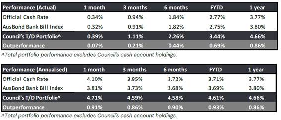
Market Update Summary
Financial markets remain volatile as the Middle East conflict continues to dampen risk sentiment, with the conflict becoming more protracted and strategically broader. The market remains focussed on the inflation consequences of the disruptions, from which central bank expectations have repriced sharply.
In the deposit market, over March, at the short-end of the curve (12 months and less), the average deposit rates offered by the domestic major banks was up to 35bp higher compared to where they were the previous month (February) after the RBA lifted official rates by a further 25bp. At the longer-end of the curve (1-5 years), the average rates were also up to 35bp higher compared to where they were the previous month. Markets are pricing in another two rate hikes for 2026.
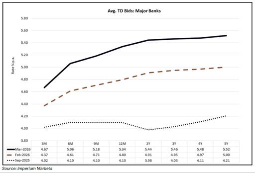
Council continues to utilise the platform Imperium Markets, to assist in conducting, managing, and reporting on Council’s investments. This provides an automated process of sourcing quotes and investing monies which is allowing Council to better address investment risks. Additional to the platform, Arlo Advisory provide investment advice on the surrounding market conditions and how Council can maximise returns within the Ministerial Order and Council’s investment policy.
|
Table 3: Investments by Fund $’000 |
|||
|
January -2026 |
February -2026 |
March -2026 |
|
|
49,899 |
55,897 |
54,717 |
|
|
Water Fund |
27,967 |
29,353 |
30,568 |
|
Sewer Fund |
71,243 |
74,053 |
74,377 |
|
TOTAL |
149,109 |
159,303 |
159,662 |
Each Fund’s allocation can only be utilised for its specific operations. For example, Water Fund cannot use its financial resources on General Fund projects.
Included in the General Fund investments are amounts that are externally restricted for specific purposes, i.e. contributions and unspent grants. In addition, there are amounts that are internally restricted by Council.
The value of outstanding government grant debtors on 31 March 2026 is $173,150.73 with $60,000 aged 4+ months. Council continues to work with our funding partners to keep these debts minimised.
Legal /Policy
Section 625 of the Local Government Act 1993 (LG Act) determines money may only be invested in a type of investment authorised by Order of the Minister for Local Government and published in the Local Government Gazette. The current Ministerial Order of Investment was published 17 February 2011.
Clause 212 of the Local Government (General) Regulation 2021 (LG Regulations) determines the Responsible Accounting Officer must provide Council with a written report setting out details of all money Council has invested under Section 625 of the LG Act.
The report must also include a Certificate as to whether the investments have been made in accordance with the LG Act, LG Regulations and Council’s Investment Policy.
Council has an Investment Policy (policy number 6.07) adopted on 25 March 2026. The policy is reviewed every four years by Council and annually by Council officers.
Impacts on Strategic/Operational/Asset Management Plan/Risk
Strategic Alignment
This report is provided in accordance with Council’s Community Strategic Plan (CSP), 2025-2029 Delivery Program and operational Plan activities
CSP Strategy: E.3 Government services have well -governed financial and strategic management processes to ensure ongoing viability and value for money.
This reporting supports the implementation of Council’s adopted Delivery Plan 2025-2029 as identified through the following core business activity undertaken by the finance team to:
· Manage Council’s borrowings and investments in accordance with Council’s Financial Strategy
Environment and Climate Change
Council considers the importance of environmental, social and governance factors in investment decision making.
As at 31 March 2026, Council’s investment portfolio included $5 million of green certified investments.
Economic
Council’s investment policy objective is to maximise returns by investing with the most favourable rate of return. Performance of investments are reported monthly, quarterly and annually.
Risk
Council policies have strict guidelines to reduce Council’s risk to capital. The following graphs provide representation of Council’s compliance to these measures.
Risk management means our investments are made giving regard to key criteria of counterparty, credit quality and maturity compliance.
At 31 March 2026, all cash and investments held are within the counterparty, credit quality and maturity policy limits.
Other legal instruments, such as the Ministerial Order referenced above, are also being used to mitigate financial risk.
Legend: Compliant Non-compliant
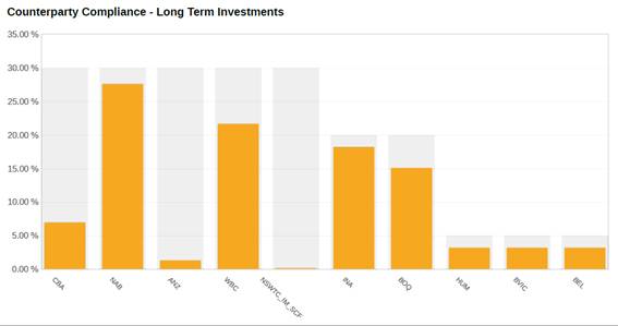
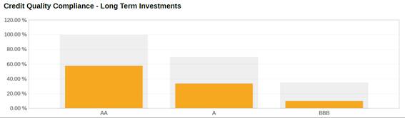
Social / Cultural
Maximising performance of returns enables the organisation to leverage additional funding received as a result of investment performance and use these towards community projects, programs and services.
Attachments
Nil
|
Item 10.4 |
10.4. Waiver of water connection charge - Bega Town Band Building (Canning St, Bega)
This report responds to Council’s 25 March 2026 resolution by outlining appropriate mechanisms to ensure there are no net financial impacts to the Bega District Band arising from water and sewer access charges.
Director Organisational Services
1. That Council note the annually adopted Revenue Policy provides discounted water and sewer access charges for non‑residential, non‑rateable community organisations, rather than a full exemption from access charges, and that this category‑based framework was adopted to support equity, consistency and financial sustainability across Council’s water and sewer funds.
2. That Council decide on the preferred option to provide an annual, transparent financial assistance arrangement to offset the net impact of water and sewer access charges levied to the Bega District Band (to the value of the access charges levied for the applicable year), subject to Council’s financial assistance governance requirements.
3. That Council staff implement the endorsed mechanism for the charges levied to the Bega District Band property for the 2025/26 rating year and confirm intention for the band to have an annual net-result of $0.00 liability for water and sewer access charges for subsequent years at the property in Canning Street, Bega.
4. That should the Bega District Band sell or rent the property at Canning Street, rates and charges will be applied in accordance with legislation and policies of Council.
Executive Summary
On 25 March 2026 Council resolved (43/26) to recognise the value and support provided by the Bega District Band at local events (citizenship ceremonies and ANZAC day) and requested staff prepare a report outlining the most appropriate mechanism to ensure there are no net financial impacts to the Band as a result of water and sewer access charges levied by Council, noting the Band does not currently pay general rates.
This matter arises from Council’s broader work to ensure consistent application of water and sewer access charges to non‑rateable community organisations. In 2022 inconsistencies were identified in the application of access charges and, following community feedback about the impact of corrected charges on organisational viability, Council resolved on 16 November 2022 (Resolution 212/22) to establish flat‑rate access charge categories for non‑rateable community organisations with transitional arrangements.
Council’s current approach in the adopted 2025-26 Revenue Policy continues this category‑based framework and does not provide a full exemption from access charges.
This report outlines options to achieve Council’s intended outcome for the Bega District Band considering governance, transparency and the integrity of Council’s adopted charging framework.
Background
On 25 March 2026, Council resolved (43/26) on Item 14.1 Waiver of water connection charge - Bega Town Band Building (Canning St, Bega) as follows:
That Council:
1. Recognises the value and support provided by the Bega Band at local events including citizenship ceremonies and ANZAC day.
2. That in recognition of their ongoing contribution to the community, council staff prepare a report for Council outlining the most appropriate mechanism to ensure there are no net financial impacts to the Bega District Band as a result of water and sewer access charges levied to the Bega District Band from Council, noting they do not currently pay general rates.
In the lead up to the 2022/23 financial year, Council undertook a review of non‑rateable properties and identified inconsistencies in the application of water and sewer access charges, including circumstances where some non‑rateable community organisations were not being charged access charges that applied under the legislative framework. When those anomalies were corrected, Council received feedback that the imposition of access charges could impact the financial viability of some community organisations.
Council considered this matter at its meeting of 16 November 2022 and resolved (Resolution 212/22) to establish new flat‑rate water and sewer access charge categories for non‑rateable community organisations, equivalent to a non‑residential 20mm connection with a 95% discharge factor, with transitional arrangements for organisations not previously paying access charges (50% in 2022/23 and full charges thereafter).
It is important to note that should Council provide further concessions to the Bega Band than already outlined above this would result in them being treated uniquely relative to all other similar community organisations.
Options
To implement the resolution of Council to provide financial assistance to the Bega District Band beyond the existing discounted access charge categories, the following options are presented:
Option 1: Annual offset arrangement (financial assistance to neutralise the access charges)
Under this option, Council would maintain the existing category‑based access charge framework (charges remain levied and transparent), and Council would provide an annual financial assistance amount to the Band equivalent to the water and sewer access charges levied for that year, so that the Band experiences no net financial impact from those access charges. This would be subject to a public exhibition process in accordance with Section 356 of the Local Government Act.
This donation option most directly implements the intent of the 25 March 2026 resolution while preserving Council’s charging framework.
Option 2 – Amend the Revenue Policy to provide an additional exemption/waiver
Under this option Council would amend the adopted Revenue Policy to charge $0.00 water and sewer access charges for the Bega District Band under its own clause. This would be subject to a public exhibition process and sets a precedent for all other non-rateable community organisations.
Option 3 – Support the Bega District Band to generate sustainable income to meet operating costs through a fee-for-service approach
Under this option, Council would not alter the existing category‑based charging framework for water and sewer access charges. Instead, Council supports the Bega District Band to strengthen its own revenue base to fund ongoing operations, including the cost of water and sewer access charges, through a transparent and lawful approach that avoids ad hoc fee waivers. This could be achieved by establishing clear and consistent arrangements for paid engagements where the Band provides services at Council‑hosted events.
It is noted that the Bega District Band has previously charged Council for services provided indicating that a service‑for‑fee model is already occurring in some form. Most recently, Council was able to secure grant funding for the expense incurred.
Option 4 – No further action (retain existing approach)
Council would take no additional steps beyond the existing charging framework and communications provided to the Band and encourage the band to introduce a fee-for-service to generate income to support their operations.
Community and Stakeholder Engagement
Engagement undertaken
Since 2022 there have been several requests in writing from the Bega District Band for council not to charge the water and sewer connection charges at their property in Canning Street, Bega. Council Officers have consistently responded and provided the reasons for the charges.
On 25 March 2026, Ms Melinda Steel on behalf of Bega District Band made a public deputation to Council regarding Councillor Porter’s motion included in the Agenda for the Ordinary Meeting of Council. Ms Melinda Steel spoke for the motion to waive the charges.
Engagement planned
Subject to Council’s decision, staff will implement the decision and advise the Bega District Band of the adopted mechanism, the evidence required to confirm annual access charge amounts, and how any annual assistance will be applied and reviewed.
Should Council proceed with Option 1 or 2, public exhibition would need to occur in accordance with the Local Government Act.
Financial and Resource Considerations
Council’s current charging framework set out in the adopted 2025–26 Revenue Policy, is a category‑based approach that provides discounted water and sewer access charges for non‑residential, non‑rateable community organisations, rather than a full exemption from access charges.
The financial impacts of this resolution are not related to expenditure of public money, rather a loss of revenue for access to public services provided to a private land-owner.
Using the adopted 2025–26 revenue policy parameters (water access base charge $315; non‑residential sewer access base with a 95% SDF charge $1,510; discount factor 0.85 for eligible non‑rateable community organisations), the indicative annual access charges would be approximately:
· Water access: $267.75
· Sewer access: $1,284.00
Combined indicative W&S access: $1,551.75
Under Option 1, the annual assistance amount would be confirmed each year based on the actual access charges levied to the Band for that rating year. It should be noted that due to the financial strategy and sustainability of Council, for several years there has been no provision in annual budgets made for Council to make donations under section 356 of the Local Government Act.
Under Option 2, the charges applied of $0.00 would be subject to public exhibition each year.
Legal /Policy
This matter sits within an established legislative and policy framework governing Council’s approach to rates, charges and financial assistance. Council’s adopted Revenue Policy already provides discounted access charges for non‑residential, non‑rateable community organisations rather than a full exemption, to support equity, consistency and financial sustainability across Council’s water and sewer funds.
Following Council’s resolution in 2022, correspondence with the Bega District Band reaffirmed that while the Band’s property at 23 Canning Street is exempt from ad valorem and base rates, water and sewer access charges remain applicable under the Local Government Act 1993 and the Local Government (Rates and Charges) Regulation 2021. The Band was also advised of Council’s established review and hardship pathways for individual circumstances in August 2023. It is further noted that since January 2025, the Bega District Band has charged Council for services provided at community events.
The resolution seeks Council officers to provide options on ensuring a nil impact for the Bega District Band for the water and sewer access charges levied under legislation in recognition of services provided to Council. From a governance perspective, this constitutes financial assistance to a single organisation beyond Council’s adopted category‑based charging framework and requires transparent documentation of the mechanism, financial impacts and evidence requirements. It would also raise considerations under section 356 of the Local Government Act 1993, which regulates the provision of financial assistance by councils. While section 356 provides exemptions where assistance is granted strictly in accordance with an adopted policy or under Chapter 15 of the Act, this decision may introduce a bespoke arrangement that is not currently provided for within Council’s adopted policies.
Regarding option 4 proposed in this report, additional legislative and policy considerations need to be highlighted. This includes competitive neutrality and value‑for‑money. While Council may engage community organisations for services, setting a performance fee specifically to equal the value of statutory water and sewer access charges to create a nil effect of the charges creates a probity risk that the arrangement is, in substance, a waiver or offset of charges rather than a value‑for‑money procurement. Council has adopted competitive neutrality principles for its declared business activities, including water and sewer, and any revenue foregone or subsidy should be determined in advance through an open and transparent process and, where relevant, treated as a community service obligation funded internally rather than absorbed by council. Council’s procurement framework requires value‑for‑money and proportional market testing and justification; therefore, if Council purchases services from the Band, the rate should be supported by evidence of reasonableness and not directly pegged to the charges applicable to the Bega District Band property at Canning Street, Bega.
Staff note that maintaining a category‑based and policy‑driven approach remains the most robust mechanism for ensuring lawful, equitable and financially sustainable decision‑making in relation to rates, charges and financial assistance.
Impacts on Strategic/Operational/Asset Management Plan/Risk
Strategic Alignment
OUR CIVIC LEADERSHIP: Government services have strong organisational practices that deliver services and facilities to meet community needs.
Core business:
· Coordination of Council’s annual fees and charges
· Review and implement financial policies and procedures
· Levy rates and manage water billing and sundry debtors
Environment and Climate Change
There are no direct environmental impacts or climate change implications arising from the recommended option.
Council’s broader water and sewer charging framework is designed to support the ongoing operation, maintenance and future investment in essential water and sewer infrastructure. Maintaining clarity and transparency in how any financial assistance is provided supports confidence in that framework.
Economic
This matter has a direct economic consideration for Council because water supply and sewerage services are declared business activities and are funded through service charges. Decisions that reduce, waive or offset charges can affect the transparency of costs, subsidies and revenue treatment for those business activities.
If Council elects to ensure there is “no net financial impact” to the Bega District Band, the economic effect is best characterised as financial assistance as foregone revenue associated with access to public utility services, rather than an operational efficiency or capital investment outcome.
Maintaining a category‑based and policy‑driven approach assists Council to manage longer‑term financial sustainability and equity considerations across other non‑rateable community organisations.
Risk
There are risks related to making decisions based on approaches by individual groups for preferential treatment. Such approaches expose Council to governance, audit and probity risks and are not consistent with best practice decision‑making. Attempting to equate community service provision directly to the monetary value of rates or charges would require a robust valuation methodology that does not presently exist.
There are several key risks associated with this matter:
Governance, audit and probity risk: There is a risk in making decisions based on individual approaches, informal advice, or ad hoc determinations regarding whether services have been provided and their value.
Equity and precedent risk: Providing a bespoke outcome for one organisation beyond the adopted category‑based framework creates a risk of expectation and flow‑on requests from other non‑rateable community organisations, which could have broader financial sustainability impacts on the water and sewer funds.
Legislative compliance risk: If the chosen option constitutes financial assistance to a single organisation, Council must consider compliance with section 356 of the Local Government Act 1993, including the requirement for at least 28 days public notice in relevant circumstances unless an exception applies. Where Council provides waivers to meet a community service obligation, the approach should be determined in advance through an open and transparent process.
Social / Cultural
Council has formally recognised the Bega District Band’s contribution to civic and community life, including support for local events such as citizenship ceremonies and ANZAC Day. The resolution underpinning this report reflects Council’s acknowledgement of the contribution of volunteers and values opportunities that promote community participation through various community organisations.
Attachments
Nil
|
Council |
22 April 2026 |
Councillor Reports
22 April 2026
12.1 Cr Daly - Community Connect Meeting - Tanja Hall......................................... 517
|
Item 12.1 |
12.1. Cr Daly - Community Connect Meeting - Tanja Hall
On Wednesday 1 April, Council hosted the first Community Connect meeting at Tanja Hall.
Cr Simon Daly
Since mid-last year, Council's Halls Committee has been discussing the idea of using the Shire's network of community halls to provide an opportunity to hear from the community, provide updates on local and shire wide issues and, importantly, collect written requests for feedback from the community to be entered into Council's Customer Request Management database for action and follow up.
The Community Connect series forms an important part of Council's Community Engagement Strategy's core aim, to strengthen local community networks and rebuild an engaged, positive, trusting and respectful relationship with the community. In total about 40 people attended the event, which was conducted as an informal discussion.
Topics of discussion included local roads and bridges (including Cuttagee Bridge, Doctor George Mountain Road, Wapengo Causeway); Council's financial position; solar and battery systems for the Hall, support with grant applications and more.
Eleven CRM submissions were also made by community members, covering a diverse range of topics including public EV charging, advocacy for improved mobile reception, assistance with rabbit control, waste collection, and affordable housing.
Providing a face-to-face opportunity to discuss critical local issues and allow an opportunity for the community to provide written requests provides a critical opportunity to better meet and understand community needs. The approach also allows for community members that may find it difficult to connect with council staff and Councillors online, over the phone or in Zingel Place a chance to be heard, have their say, get answers and information of issues important to them.
I'd like to thank the CEO, staff and Councillors for their attendance at Tanja and encourage all Councillors to attend future meetings. Council will hold the next Community Connect session at Murrah Hall on Tuesday 5 May, followed up by Candelo and Nethercote in June and July respectively.
Attachments
Nil
|
Council |
22 April 2026 |
Questions with Notice
22 April 2026
15.1 Cr Porter - Jellat Flats resurfacing..................................................................... 519
|
Item 15.1 |
15.1. Cr Porter - Jellat Flats resurfacing
With the recent announcement that Jellat Flats, including the section near the cattle crossing, will be resurfaced in the coming months, I would like to follow up on 2025.03.19 Notice of Motion, which resolved that Council would seek and identify grant funding for improvements to the electronic signage, crossing underpass, or any other way to improve the safety of motorists at the cattle crossings across the Bega Valley.
Could you please advise whether funding for this initiative is likely to be available?
If funding is not yet secured, would it be possible to undertake preparatory works during the resurfacing, such as installing underground conduit or pipes for electrical cabling? This would avoid the need to excavate the newly completed road surface at a later date should lighting infrastructure be installed.
Director Infrastructure
Staff response
At the ordinary Council meeting on 19 March 2025 Council resolved:
1. That staff report back to Council on options for grant funded improvements to the electronic signage, crossing underpass, or any other way to improve the safety of motorists at the cattle crossings across the Bega Valley.
2. That Council advocate to the Federal and State Government for a funding program to address road safety at cattle crossings in Regional NSW.
At the ordinary Councill meeting on 16 April 2025 staff prepared a report in response to the above resolution. At the time of this report there were no specific grant funding opportunities available targeting cattle crossings. Further, previous grant opportunities have only been made available to primary producers, often requiring a significant co-contribution. Grant funding opportunities have not been available to Councils.
Following this report, Council resolved:
That Council advocate to State and Federal Governments to fully fund a cattle crossing improvement program to improve road user safety without negatively impacting the important agricultural sector.
There are still no state or federal grants available to date, and Council continues to advocate when meeting with the relevant agencies.
In relation to Council undertaking preparatory work during the upcoming road resurfacing along Jellat Flats, there are currently reliable and sustainable signage options available that integrate radio-operated flashing amber beacons with solar panels and rechargeable batteries, therefore eliminating the need for any underground cabling or excavation of the road surface.
Attachments
Nil
|
Council |
22 April 2026 |
Questions without Notice
22 April 2026
16.1 Cr Fitzpatrick - Merimbula CBD parking............................................................ 521
Council 22 April 2026 |
Item 16.1 |
16.1. Cr Fitzpatrick - Merimbula CBD parking
At the 25 February 2026 ordinary council meeting Cr Fitzpatrick asked:
With reference to the 2015 Merimbula CBD plans and Spiire plans, in 2016 Council had a report showing a number of carparks from the then Director Business and Strategy that said we had over 200 surplus carparks although the locations were all around Merimbula, is there any increase in Merimbula CBD parking since the 2015 masterplan and how will the Robert Green development impact car parking in the area?
Chief Executive Officer, Mr Anthony McMahon advised there have been things done and we will bring back what has been done since the 2015 masterplan. Just as an indication there have been some major developments that have happened in Merimbula since the masterplan that council consciously got conditions placed on them around parking and other impacts in the area that we can bring more information back on.
Director Infrastructure
Staff response:
· Woolworths was planned and commissioned with a total of 283 carparks consisting of 152 for the supermarket, 127 to meet the restriction on title for the provision of parking for the Merimbula RSL Development and 4 spaces to meet the loss of on-street parking.
· Aldi was planned and commissioned with a total of 90 carparks consisting of 68 for the supermarket, 18 to satisfy the restriction as to user denoted on Lot 949 and 4 spaces to meet loss of on street parking in Main Street.
· Greens Market Street development, 29-33 Market Street (DA 2022.62) will provide 116 onsite spaces (49 of which are more than the minimum parking requirements for this type of development).
· 21 Beach Street (DA 2020.164) will provide 14 spaces to service the development and VPA to pay Council for 2 additional public spaces.
· 25 Beach Street (DA2021.1400) will provide 19 spaces onsite to service the development.
· A smart parking trial was conducted in Palmer Lane car park Merimbula from 17 December 2018 to 14 April 2019. The results revealed that even during peak times the car park was never fully utilised.
Attachments